We have some great sponsors for the Weather Talk Blog. Please let our sponsors know that you appreciate their support for the Weather Talk Blog.
Milner and Orr Funeral Home and Cremation Services located in Paducah, Kentucky and three other western Kentucky towns – at Milner and Orr they believe in families helping families. You can find Milner and Orr on Facebook, as well.
![]()
.

For all of your families eye care needs. Visit their web-site here. Or, you can also visit their Facebook page.
.

Best at Enabling Body Shop Profitability since 1996. Located In Paducah Kentucky and Evansville Indiana; serving all customers in between. They provide Customer Service, along with all the tools necessary for body shops to remain educated and competitive. Click the logo above for their main web-site. You can find McClintock Preferred Finishes on Facebook, as well
.

Duck/goose decoys? Game calls? Optics? We have you covered! Click the logo above or visit Final Flight on Facebook, as well.
.
.
I have launched the new weather texting service! I could use your help. Be sure and sign up and fully support all of the weather data you see each day.
This is a monthly subscription service. Supporting this helps support everything else. The cost is $3 a month for one phone, $5 a month for three phones, and $10 a month for seven phones.
For more information visit BeauDodsonWeather.com
Or directly sign up at Weathertalk.com


This forecast update covers far southern Illinois, far southeast Missouri, and far western Kentucky. See the coverage map on the right side of the blog.
Remember that weather evolves. Check back frequently for updates, especially during active weather.

Monday night – Breezy early. Strong winds possible with a line of showers that will push through the area. Cloudy with a few showers early. Then, a chance for patchy light drizzle late tonight. Small chance of frozen precipitation late tonight (less than 10% chance). I believe most of the precipitation will end before the colder air arrives.
Temperatures: Lows from 30-36 degrees
Winds: Winds southwest early in the evening at 10-20 mph. Gusty. Then, winds becoming more west late tonight at 5-10 mph.
What is the chance for precipitation? 50% chance early in the evening. 20% late (after midnight).
Coverage of precipitation? Scattered early. Isolated late.
My confidence in this part of the forecast verifying is High
Should I be concerned about snow or ice? Small chance of a flurry or freezing drizzle (less than 10% chance)
Should I cancel my outdoor plans? No
Is severe weather expected? No
What impact is expected? Wet roadways where rain occurs. Strong winds.
Tuesday – Mostly cloudy. Chilly.
Temperatures: Highs will range 35-40 degrees
Winds: Northwest winds at 4-8 mph with gusts to 12 mph
What is the chance for precipitation? 0%
Coverage of precipitation? None
My confidence in this part of the forecast verifying is High
Should I be concerned about snow or ice? No
Should I cancel my outdoor plans? No
Is severe weather expected? No
What impact is expected? None
Tuesday night – Cloudy. Seasonably cold.
Temperatures: Lows from 22-28
Winds: North/northwest winds at 5 mph
What is the chance for precipitation? 0%
Coverage of precipitation? None
My confidence in this part of the forecast verifying is High
Should I be concerned about snow or ice? No
Should I cancel my outdoor plans? No
Is severe weather expected? No
What impact is expected? None
Wednesday – Quite a few clouds possible. We will have to see how quick the clouds exit on Wednesday. Data is a bit mixed on this subject.
Temperatures: Highs will range 35-40 degrees.
Winds: North winds at 5 mph.
What is the chance for precipitation? 0%
Coverage of precipitation? None
My confidence in this part of the forecast verifying is high
Should I be concerned about snow or ice? No
Should I cancel my outdoor plans? No
Is severe weather expected? No
What impact is expected? None
Wednesday night – Perhaps some clearing.
Temperatures: Lows from 24-28
Winds: North winds becoming east/southeast winds at 5 mph
What is the chance for precipitation? 0%
Coverage of precipitation? None
My confidence in this part of the forecast verifying is High
Should I be concerned about snow or ice? No
Should I cancel my outdoor plans? No
Is severe weather expected? No
What impact is expected? None
Thursday – Partly sunny. Not as cold.
Temperatures: Highs will range 40-45 degrees.
Winds: Southeast winds at 5-10 mph.
What is the chance for precipitation? 0%
Coverage of precipitation? None
My confidence in this part of the forecast verifying is high
Should I be concerned about snow or ice? No
Should I cancel my outdoor plans? No
Is severe weather expected? No
What impact is expected? None


Don’t forget to check out the Southern Illinois Weather Observatory web-site for weather maps, tower cams, scanner feeds, radars, and much more! Click here

An explanation of what is happening in the atmosphere over the coming days…
Highlights
1. Dry and cool for Tuesday into Thursday
2. Watching a system for Sunday into early next week. Storms?
Wow, 50s today over the snow pack region of southern Illinois, western Kentucky, and northwest Tennessee. Folks, that is just amazing. What a ride. Our regions weather can be fascinating.
Here is the 2 pm temperature map.

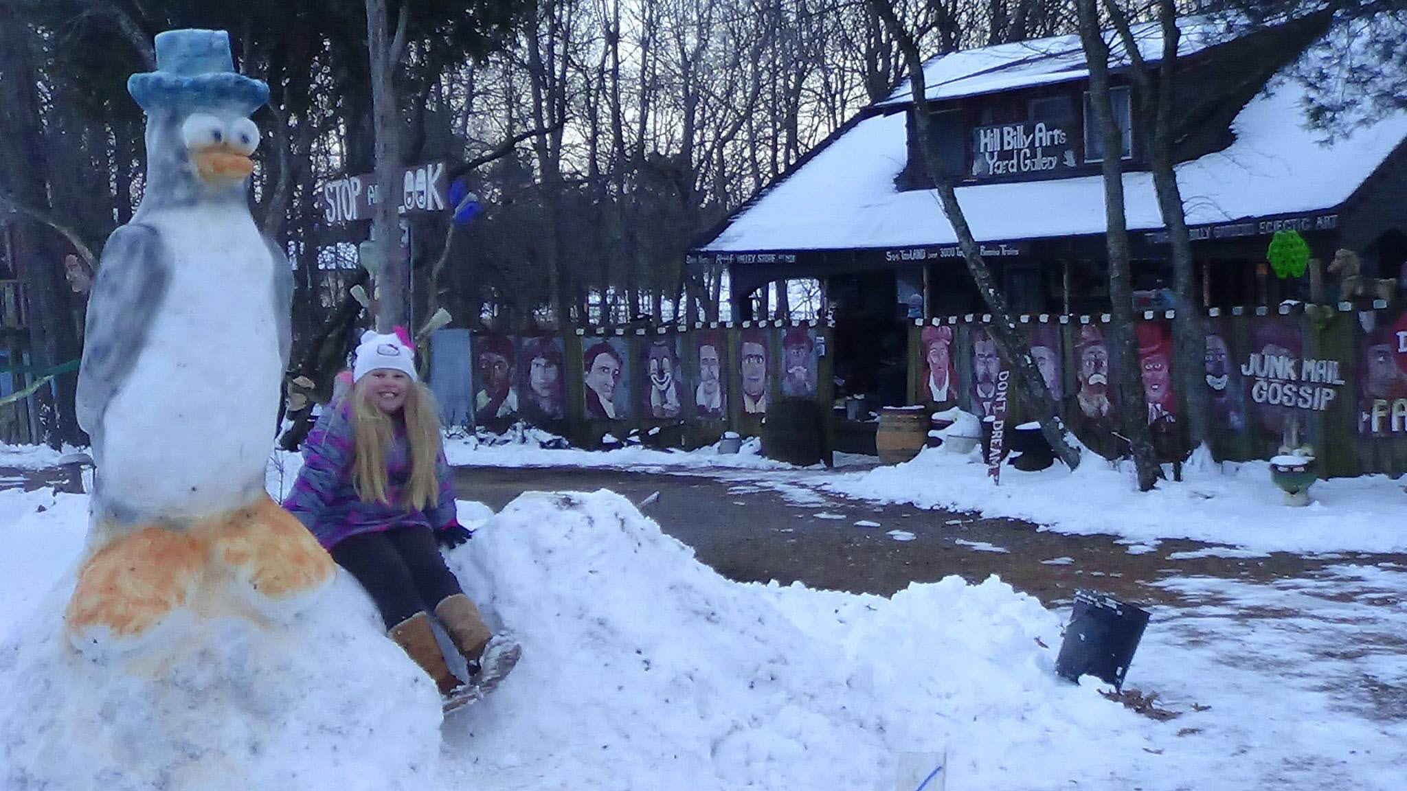
Check out this photograph sent in by Keith Holt. His daughter, Brook and her larger than life Penguin. Click for a larger view.
Great job!
A cold front will pass through the region on Monday evening and night. Our mild Monday temperatures were in response to this cold front. An area of low pressure was passing well to our north on Monday afternoon/evening. And, since low pressure rotates counter-clockwise, this was pulling warmer air into our region, from the southern United States, ahead of the front.
Strong winds possible along the front.
WEATHER RADAR PAGE – Click here –
The cold front will push through the region on Monday night. A few patchy light showers and drizzle possible. Colder air will follow. Morning lows on Tuesday will dip into the upper 20s and lower 30s. And, we will remain quite chilly on Tuesday. Highs will likely remain mostly in the 30s.
Dry weather is anticipated for much of the new work week.
Another cold front moves through the region on Thursday. We should warm up a few degrees ahead of the front. Perhaps some 40s. I am expecting the front to move through our area without any precipitation.
A more significant weather system is anticipated to develop over the Central United States later this weekend into the first few days of February. An area of low pressure is currently expected to develop over Kansas and then move northeast into Iowa and Missouri. Depending on the strength and track of this system, we may have to deal with showers and thunderstorms on Sunday, Monday, and Tuesday. Likely not all three days. But, in that time frame.
Let’s keep monitoring it. Right now, it appears we will be on the warm side of this system.
Speaking of warmth. Check out this Weatherbell.com image. It shows temperature anomalies for early next week. Red would equal well above normal temperatures.
Normal low temperatures for this time of the year are around 24 degrees.
Normal high temperatures for this time of the year are around 42 degrees.
This map would indicate temperatures averaging 5-10 degrees above normal.

Let’s look at the official temperature outlook for January 30th into the first couple of days of February. This is in response to a deep storm system passing well to our northwest and north. Thus, it would pull warmer air northward.
This map represents the percentage chance of above normal temperatures.

Zooming in on our region

Let’s take a look at the storm system on the GFS guidance
The map below is for this coming Saturday evening. The blue is snow. Green is rain. You can see a weak area of low pressure over southwest Kansas. This is not the main storm system.

Moving ahead to Monday morning (keep in mind this is a long way off).

Moving ahead to Tuesday, February 2nd (jumped ahead a day). You can see a deep area of low pressure over eastern Kansas. Lot of moisture being pulled northward ahead of this system. We could even have thunderstorms if the track is right. Heavy snow back over South Dakota and Nebraska. Again, seven days away. Long way for models to nail a storm track.

This last image is for Tuesday evening (February 2nd). Dark green represents moderate to heavy downpours and maybe thunderstorms.
On this map, again seven days away, the area of low pressure has deepened to 994 mb. Decent low. You can see it wound up over northwest Missouri. The cold front trails into Illinois, Missouri, Arkansas, and Louisiana. Showers and storms ahead of the front. Snow, well to our north and northwest.

How about a few more images from the massive winter storm that pushed through the Eastern United States over the past few days.
Check out these incredible snow totals along the East Coast of the United States. FEET of snow.

Pulling out a bit more. This is a WeatherBell.com image. Snowfall totals from Jonas (The Weather Channel names winter storms).

Here is a NOAA/NWS image of the storm system. Click for a larger view.

WEATHER RADAR PAGE – Click here —
We also have a new national interactive radar – you can view that radar by clicking here.
Local interactive city radars include St Louis, Mt Vernon, Evansville, Poplar Bluff, Cape Girardeau, Marion, Paducah, Hopkinsville, Memphis, Nashville, Dyersburg, and all of eastern Kentucky – these are interactive radars. Local city radars – click here
NOTE: Occasionally you will see ground clutter on the radar (these are false echoes). Normally they show up close to the radar sites – including Paducah.


No significant winter weather expect. Small chance for a flurry or brief period of patchy freezing drizzle late Monday night. But, most likely it will just be rain ending before the colder air arrives.

Tuesday – No snow or ice anticipated.
Tuesday Night – No snow or ice anticipated.
Wednesday – No snow or ice anticipated.
Thursday – No snow or ice anticipated.
Friday – No snow or ice anticipated.

No major changes in this package.

No major concerns for the next 48 hours.

No

The wild card in this evening will be a storm system around the beginning of February. Some data indicates thunderstorms will be possible.

How much precipitation should we expect over the next few days?
No precipitation on Tuesday or Wednesday.

Can we expect severe thunderstorms over the next 24 to 48 hours? Remember that a severe thunderstorm is defined as a thunderstorm that produces 58 mph winds or higher, quarter size hail or larger, and/or a tornado.
The thunderstorm threat level will be a ZERO on Tuesday through Friday.
Will be watching the first few days of February for possible thunderstorms, depending on storm track.

Here is the official 6-10 day and 8-14 day temperature and precipitation outlook. Check the date stamp at the top of each image (so you understand the time frame).
The forecast maps below are issued by the Weather Prediction Center (NOAA).


The latest 8-14 day temperature and precipitation outlook. Note the dates are at the top of the image. These maps DO NOT tell you how high or low temperatures or precipitation will be. They simply give you the probability as to whether temperatures or precipitation will be above or below normal.


Here are the current river stage forecasts. You can click your state and then the dot for your location. It will bring up the full forecast and hydrograph.
Click Here For River Stage Forecasts…

Who do you trust for your weather information and who holds them accountable?
I have studied weather in our region since the late 1970’s. I have 37 years of experience in observing our regions weather patterns. My degree is in Broadcast Meteorology from Mississippi State University and an Associate of Science (AS). I am currently working on my Bachelor’s Degree in Geoscience.
My resume includes:
Member of the American Meteorological Society.
NOAA Weather-Ready Nation Ambassador.
Meteorologist for McCracken County Emergency Management. I served from 2005 through 2015.
I own and operate the Southern Illinois Weather Observatory.
Recipient of the Mark Trail Award, WPSD Six Who Make A Difference Award, Kentucky Colonel, and the Caesar J. Fiamma” Award from the American Red Cross.
In 2009 I was presented with the Kentucky Office of Highway Safety Award.
Recognized by the Kentucky House of Representatives for my service to the State of Kentucky leading up to several winter storms and severe weather outbreaks.
I am also President of the Shadow Angel Foundation which serves portions of western Kentucky and southern Illinois.
There is a lot of noise on the internet. A lot of weather maps are posted without explanation. Over time you should learn who to trust for your weather information.
My forecast philosophy is simple and straight forward.
- Communicate in simple terms
- To be as accurate as possible within a reasonable time frame before an event
- Interact with you on Twitter, Facebook, and the blog
- Minimize the “hype” that you might see on television or through other weather sources
- Push you towards utilizing wall-to-wall LOCAL TV coverage during severe weather events
I am a recipient of the Mark Trail Award, WPSD Six Who Make A Difference Award, Kentucky Colonel, and the Caesar J. Fiamma” Award from the American Red Cross. In 2009 I was presented with the Kentucky Office of Highway Safety Award. I was recognized by the Kentucky House of Representatives for my service to the State of Kentucky leading up to several winter storms and severe weather outbreaks.
If you click on the image below you can read the Kentucky House of Representatives Resolution.

Many of my graphics are from www.weatherbell.com – a great resource for weather data, model data, and more


You can sign up for my AWARE email by clicking here I typically send out AWARE emails before severe weather, winter storms, or other active weather situations. I do not email watches or warnings. The emails are a basic “heads up” concerning incoming weather conditions.