We have our first sponsor for the blog. Milner and Orr Funeral Home and Cremation Services located in Paducah, Kentucky and three other western Kentucky towns – at Milner and Orr they believe in families helping families.
![]()

This forecast update covers far southern Illinois, far southeast Missouri, and far western Kentucky. See the coverage map on the right side of the blog.
Remember that weather evolves. Check back frequently for updates, especially during active weather.
Monday – Cloudy with a 40% chance for some light rain or snow showers this afternoon. High temperatures in the 30’s. Northwest winds at 5-15 mph switching to the southwest this afternoon at 5-10 mph.
Morning School Bus Stop Weather – Cloudy. Temperatures will be in the upper 20’s and lower 30’s. Northwest winds at 5-15 mph
Afternoon School Bus Stop Weather – Cloudy with a 40% chance for a rain or snow shower. Temperatures will be in the 30’s. Southwest winds at 5-10 mph.
Monday night – Cloudy. A 40% chance for a snow shower. Low temperatures in the upper 20’s or lower 30’s. Southwest winds becoming north winds at 5-10 mph.
Tuesday – A mix of sun and clouds. A 20% chance for light rain or rain/snow showers. Cool. Highs in the 40’s. North winds becoming northeast winds at 5-10 mph.
Tuesday night – Partly cloudy sky conditions. Cool. Lows in the 20’s. North to northeast winds at 5-10 mph.
Wednesday – Partly cloudy. A bit milder. High’s mostly in the upper 40’s – might see some 50 degree readings. East winds at 5-10 mph. Gusts to 15 mph.

Current Temperatures Around The Local Area


An explanation of what is happening in the atmosphere over the coming days…
Are you interested in severe weather forecasting? You will want to tune in for these classes…
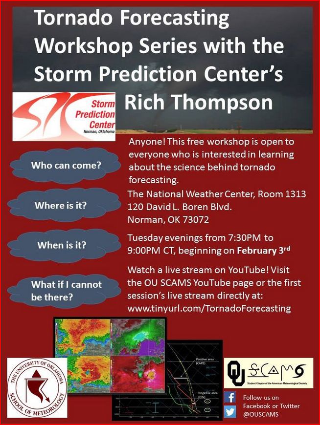
You can watch it live at this URL
Our regions weather synopsis…
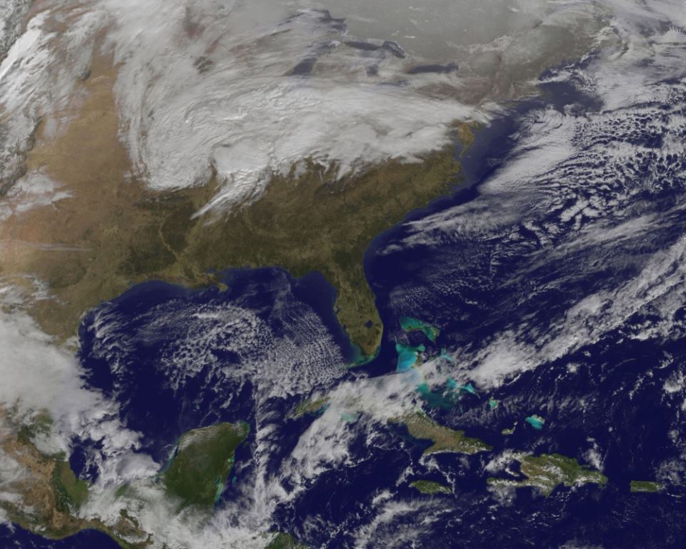
The area of low pressure that brought rain to much of the region on Sunday is pushing off to the east and northeast. This system is forecast to become a monster snowstorm for portions of the northeast United States. Blizzard watches and warnings cover a large chunk of real estate from New York City to Boston – and near those areas. Some areas may pick up feet of snow. So, when you turn on the news and see the wall to wall blizzard coverage…that was our rain maker.
Here is what the storm looked like as it moved over our region – visible satellite image. You can see the comma shape to the cloud shield – the low was over southern Illinois when this satellite image was downloaded.
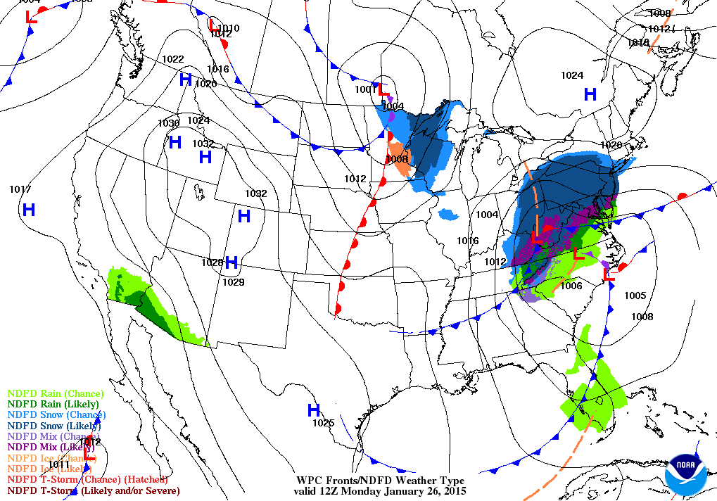
Here is the Monday morning weather map – you can see the big eastern snowstorm tracking towards the northeast
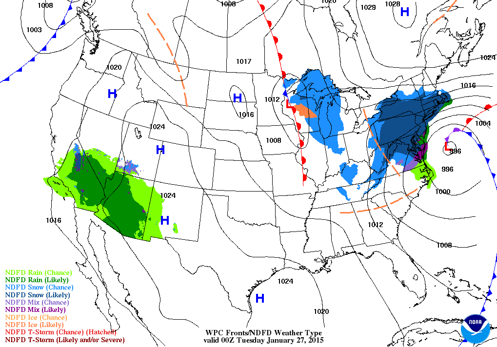
Here is the forecast weather map for 6 pm this evening
A fairly calm week of weather is ahead of us. We have a couple of weak weather systems that will skirt our region. Each one of them will bring an increase in clouds and a small chance for light rain or snow showers. Right now this does not look to be a big deal.
The first system will arrive later this afternoon (Monday afternoon) and evening. Maybe some light rain showers or rain/snow showers. Another one arrives late Wednesday night and Thursday. Looks to be warm enough for the Wednesday night/Thursday system that it would be rain.
Temperatures will be cool this week, but nothing extreme or out of the ordinary.
Sunday’s rain was much needed. Drought conditions continue to worsen over some of our counties. We will take whatever rain will can muster up.
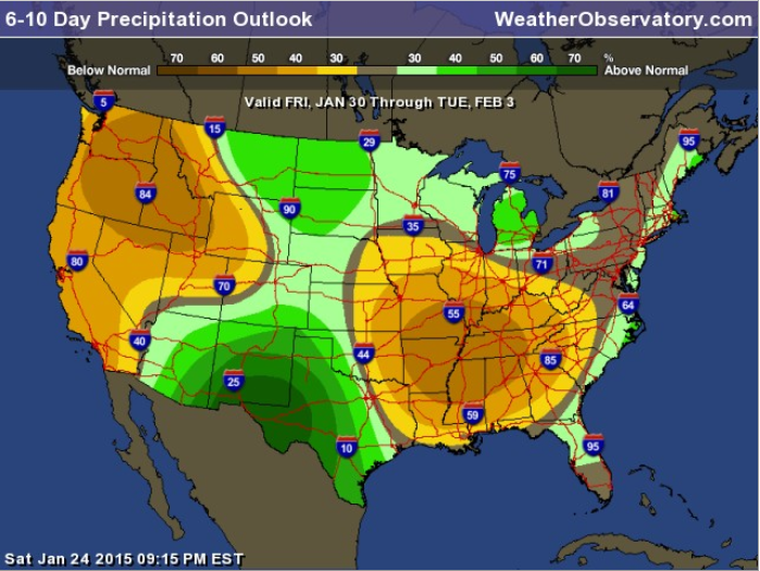
Here is the latest 6-10 and 8-14 day precipitation outlook. Not the best news. There are some signals for precipitation in the long range, but they are far from certain. The brown areas of this map indicate that odds favor below normal precipitation.
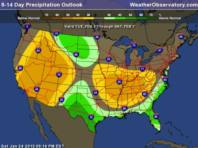
And here is the 8-14 day precipitation outlook
I am watching colder air as we push into the weekend and the first week of February. Just how cold remains a question. Also watching several storm systems in the extended forecast. See that discussion below in the extended forecast discussion box.
Would you like to WIN a snowflake? 🙂
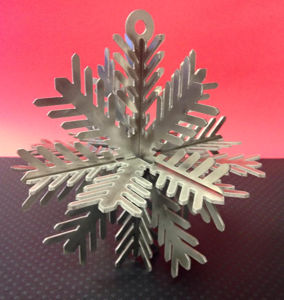
G&C Multi-Services is running a contest. G&C is one of the WeatherTalk sponsors.
To celebrate their tenth year of business, they are going to have some giveaways! First up, is this stainless steel snowflake cut on their OMAX waterjet cutting system.
To enter, Like their page, Share the snowflake post, and Comment below the snowflake! Be sure to do all three!
***Winner will be drawn on January 30, and winner is responsible for pick up or shipping. ***
Here is their Facebook page
https://www.facebook.com/pages/G-C-Multi-Services-llc/309440883977
Did you know that the Weather Observatory is funded by people like you? I rely on ad’s on this blog and individual donations. PayPal also allows you to set up a monthly recurring donation. I have had several people give $5, $10, and $20 a month. A recurring donation helps keep the weather information flowing. If you enjoy this blog, the Twitter account, the Facebook interaction, the weather radars, and all of the other information then consider making a donation or setting up a recurring donation (if you don’t use PayPal then contact me through email about how you can mail a donation) beaudodson@usawx.com
Thank you for your support!

Added light precipitation chances for late on Monday and Monday night.

Maybe some spotty slick spots this morning from moisture left over from Sunday’s rain showers.
A few snow showers possible this afternoon.
Check out our newest sponsors $5 meal! The DQ Grill and Chill (located across from Noble Park in Paducah, Kentucky) is the newest WeatherTalk Blog sponsor! A local business helping to sponsor the weather information that you have come to love so much.
They have a Facebook Page and I encourage you to check it out. DQ Grill and Chill on Facebook


The wild card tells you where the uncertainties are in the forecast
Wild card in this forecast – the wild card in this forecast will be whether or not we have some spotty snow showers late on Monday and Monday night.

Can we expect severe thunderstorms over the next 24 to 48 hours? Remember that a severe thunderstorm is defined as a thunderstorm that produces 58 mph winds or higher, quarter size hail or larger, and/or a tornado.
Thunderstorm threat level is ZERO


Will I need to take action?
Overnight temperatures will have fallen into the 20’s. There could be a few slick spots if moisture was left on roadways. Use care early this morning.
Some snow showers this afternoon.

How much precipitation should we expect over the next few days?
Only light precipitation is in the forecast this week. Several weak systems will push south and east from the Northern Plains. They will be moisture starved in our local area. But, there is at least a chance for some light rain or snow from time to time
We have a new sponsor! G&C Multi-Services out of Paducah, Kentucky. G & C Multi-Services is a service provider in Western Kentucky that provides industrial and commercial equipment fabrication, machine troubleshooting, repair and maintenance, and installation. They can custom fabricate steel, stainless, and aluminum products per customer specifications.
Visit their web-site here. Or click the ad below! They have a Facebook page and it can be viewed here.


Maybe some light rain and snow showers this afternoon.
Another chance for rain showers late Wednesday night or Thursday. Looks too warm for that to be snow.
I continue to monitor colder air as we move towards the weekend into next week. But, whether or not we get some precipitation into the cold air is still questionable.

This section of the blog is speculative forecast information. Because it is past the range of what meteorologists can forecast accurately, it should be considered speculation. Anything past day 5 is considered a long range forecast.
The longer range continues to point towards a shot or two of colder air as we move towards this coming weekend into next week. The models have backed off WAY OFF the intensity of the cold. The models have flip flopped. When they do that it means we have to be skeptical of what they are showing.
It does appear the cold air will arrive. The question will be how cold.
The other question is whether or not a storm system or two will mix in with the colder air. The models have been back and forth on showing a potential system later this weekend and next week. So…we continue to watch.
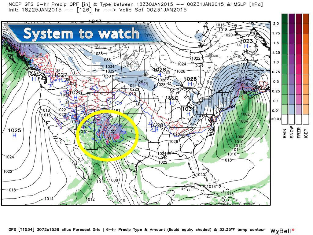
I am watching one system for this coming weekend. Right now it is a southern system. It will likely spread precipitation into parts of Oklahoma and Texas. The question then becomes…where does it go from there.
This is the system to watch – this is the Friday evening weather map as depicted by the GFS model.

Who do you trust for your weather information and who holds them accountable?
I have studied weather in our region since the late 1970’s. I have 37 years of experience in observing our regions weather patterns. My degree is in Broadcast Meteorology from Mississippi State University and an Associate of Science (AS). I am currently working on my Bachelor’s Degree in Geoscience. Just need to finish two Spanish classes!
I am a member of the American Meteorological Society. I am a NOAA Weather-Ready Nation Ambassador. And, I am the Meteorologist for McCracken County Emergency Management.
I own and operate the Southern Illinois Weather Observatory.
There is a lot of noise on the internet. A lot of weather maps are posted without explanation. Over time you should learn who to trust for your weather information.
My forecast philosophy is simple and straight forward.
- Communicate in simple terms
- To be as accurate as possible within a reasonable time frame before an event
- Interact with you on Twitter, Facebook, and the blog
- Minimize the “hype” that you might see on television or through other weather sources
- Push you towards utilizing wall-to-wall LOCAL TV coverage during severe weather events
I am a recipient of the Mark Trail Award, WPSD Six Who Make A Difference Award, Kentucky Colonel, and the Caesar J. Fiamma” Award from the American Red Cross. In 2009 I was presented with the Kentucky Office of Highway Safety Award. I was recognized by the Kentucky House of Representatives for my service to the State of Kentucky leading up to several winter storms and severe weather outbreaks.
If you click on the image below you can read the Kentucky House of Representatives Resolution.

I am also President of the Shadow Angel Foundation which serves portions of western Kentucky and southern Illinois.

We have regional radars and local city radars – if a radar does not seem to be updating then try another one. Occasional browsers need their cache cleared. You may also try restarting your browser. That usually fixes the problem. Occasionally we do have a radar go down. That is why I have duplicates. Thus, if one fails then try another one.
If you have any problems then please send me an email beaudodson@usawx.com
WEATHER RADAR PAGE – Click here —
We also have a new national interactive radar – you can view that radar by clicking here.
Local interactive city radars include St Louis, Mt Vernon, Evansville, Poplar Bluff, Cape Girardeau, Marion, Paducah, Hopkinsville, Memphis, Nashville, Dyersburg, and all of eastern Kentucky – these are interactive radars. Local city radars – click here
NOTE: Occasionally you will see ground clutter on the radar (these are false echoes). Normally they show up close to the radar sites – including Paducah.

Regional Radar – Click on radar to take you our full radar page.


Regional Radar
![]()
Current WARNINGS (a warning means take action now). Click on your county to drill down to the latest warning information. Keep in mind that there can be a 2-3 minute delay in the updated warning information.
I strongly encourage you to use a NOAA Weather Radio or warning cell phone app for the most up to date warning information. Nothing is faster than a NOAA weather radio.


Color shaded counties are under some type of watch, warning, advisory, or special weather statement. Click your county to view the latest information.

Missouri Warnings

Illinois Warnings

Kentucky Warnings

Please visit your local National Weather Service Office by clicking here. The National Weather Service Office, for our region, is located in Paducah, Kentucky. They have a lot of maps and information on their site. Local people…local forecasters who care about our region.


Here is the official 6-10 day and 8-14 day temperature and precipitation outlook. Check the date stamp at the top of each image (so you understand the time frame).
The forecast maps below are issued by the Weather Prediction Center (NOAA).


The latest 8-14 day temperature and precipitation outlook. Note the dates are at the top of the image. These maps DO NOT tell you how high or low temperatures or precipitation will be. They simply give you the probability as to whether temperatures or precipitation will be above or below normal.


Many of my graphics are from www.weatherbell.com – a great resource for weather data, model data, and more


This blog was inspired by ABC 33/40’s Alabama Weather Blog – view their blog
Current tower cam view from the Weather Observatory- Click here for all cameras.

Southern Illinois Weather Observatory

The Weather Observatory

Southern Illinois Weather Observatory
WSIL TV 3 has a number of tower cameras. Click here for their tower camera page & Illinois Road Conditions

Marion, Illinois
WPSD TV 6 has a number of tower cameras. Click here for their tower camera page & Kentucky Road Conditions & Kentucky Highway and Interstate Cameras

Downtown Paducah, Kentucky
Benton, Kentucky Tower Camera – Click here for full view

Benton, Kentucky

I24 Paducah, Kentucky

I24 Mile Point 9 – Paducah, KY

I24 – Mile Point 3 Paducah, Kentucky

You can sign up for my AWARE email by clicking here I typically send out AWARE emails before severe weather, winter storms, or other active weather situations. I do not email watches or warnings. The emails are a basic “heads up” concerning incoming weather conditions.