We have our first sponsor for the blog. Milner and Orr Funeral Home and Cremation Services located in Paducah, Kentucky and three other western Kentucky towns – at Milner and Orr they believe in families helping families.
![]()

This forecast update covers far southern Illinois, far southeast Missouri, and far western Kentucky. See the coverage map on the right side of the blog.
Remember that weather evolves. Check back frequently for updates, especially during active weather.
Sunday – Cloudy. Rain showers and light rain – occasionally a moderate shower. A chance for a rumble of thunder. Cool. Highs mainly in the 40’s. Southwest winds becoming northwest towards evening. winds of 5-10 mph early becoming 10-15 mph in the afternoon. Gusty perhaps at times. Seasonable temperatures – perhaps a little above normal.
WEATHER RADAR PAGE – Click here —
Morning School Bus Stop Weather – No school today
Afternoon School Bus Stop Weather – No school today
Sunday night – Precipitation will come to an end. Perhaps there will be enough cold air to change the rain showers over to some snow showers. Lows in the upper 20’s to lower 30’s. North/northwest winds at 10-15 mph. Gusty early. Seasonable temperatures.
Monday – Mostly cloudy sky conditions during the morning. A chance for light shower or snow shower. Cool. Highs in the upper 30’s and lower 40’s. Northwest winds becoming west/southwest winds at 5-10 mph. Near normal temperatures to slightly below normal temperatures.
Monday night – Mostly cloudy a chance for a light shower or snow shower. Cool. Lows in the upper 20’s and lower 30’s. Northwest winds at 5-10 mph. Near normal temperatures.
Tuesday – A mix of sun and clouds. Small chance for a light shower or snow shower in the morning. Perhaps more sun over our southwest counties in southeast Missouri vs more clouds over our northeast counties. Cool temperatures. Highs in the lower to middle 40’s. Northwest/north winds – variable at times. Speeds of 5-10 mph. Gusts to 15 mph Near normal temperatures.

Current Temperatures Around The Local Area


An explanation of what is happening in the atmosphere over the coming days…
A clipper system (which will eventually become a big northeast snowstorm) will move into our region today (Sunday). This clipper will push into the Ohio Valley and drag a cold front with it. Rain will develop over our region on Sunday morning. The rain will linger into the evening.
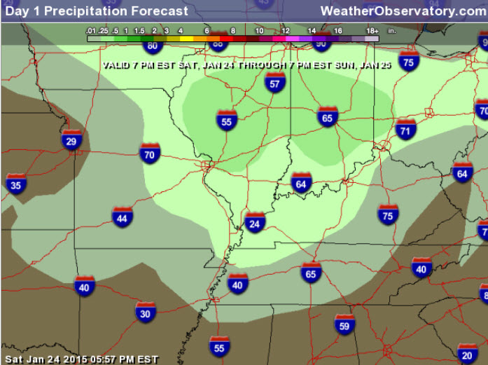
Rainfall totals of 0.25″-0.75″ with locally heavier amounts possible. Had to increase totals as some heavier bands have formed in the area. Portions of southeast Missouri have had more than 1″.
Tonight, as colder air filters into the area, we may see the rain briefly change to flurries or light snow. Not expecting any problems.
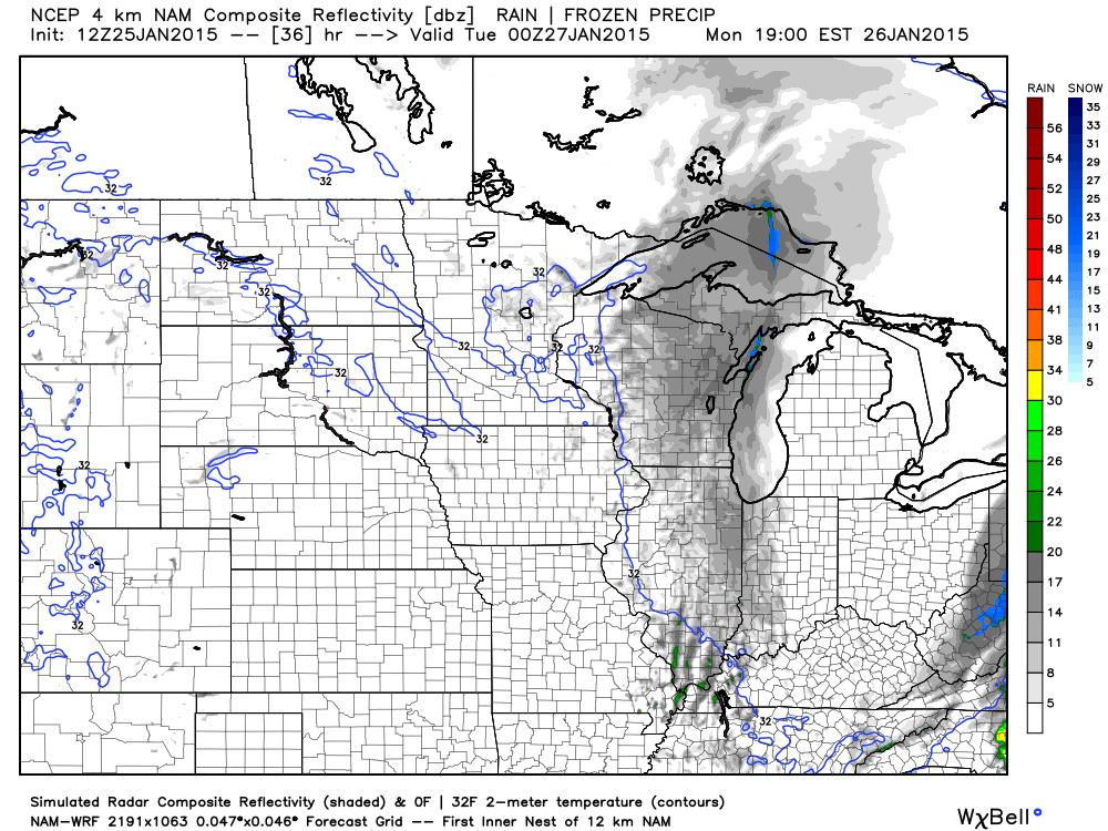
Let’s track our little clipper as it dives southeast today – this is the 6 to 8 am weather map. You can see the area of low pressure over northeast Missouri into Illinois. This is WAY further southwest than I thought the low would travel. You can see the green area (rain) and blue (snow).
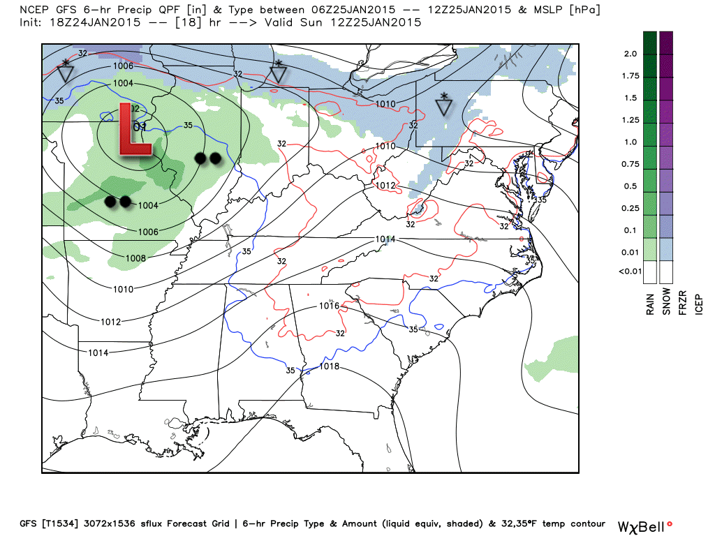
Then later in the morning – the low continues to move southeast.
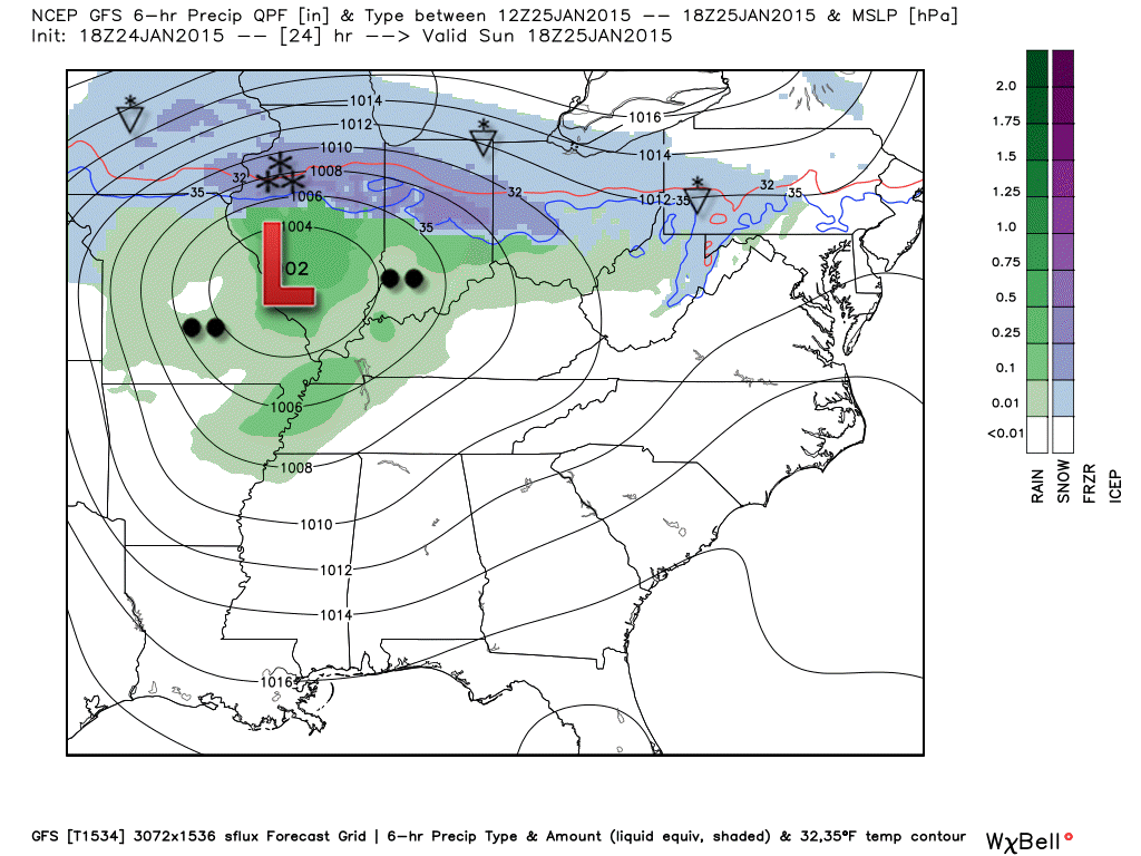
By afternoon the low is pushing through our region. Quite a few scattered rain showers in our region. You can see snow to the north.
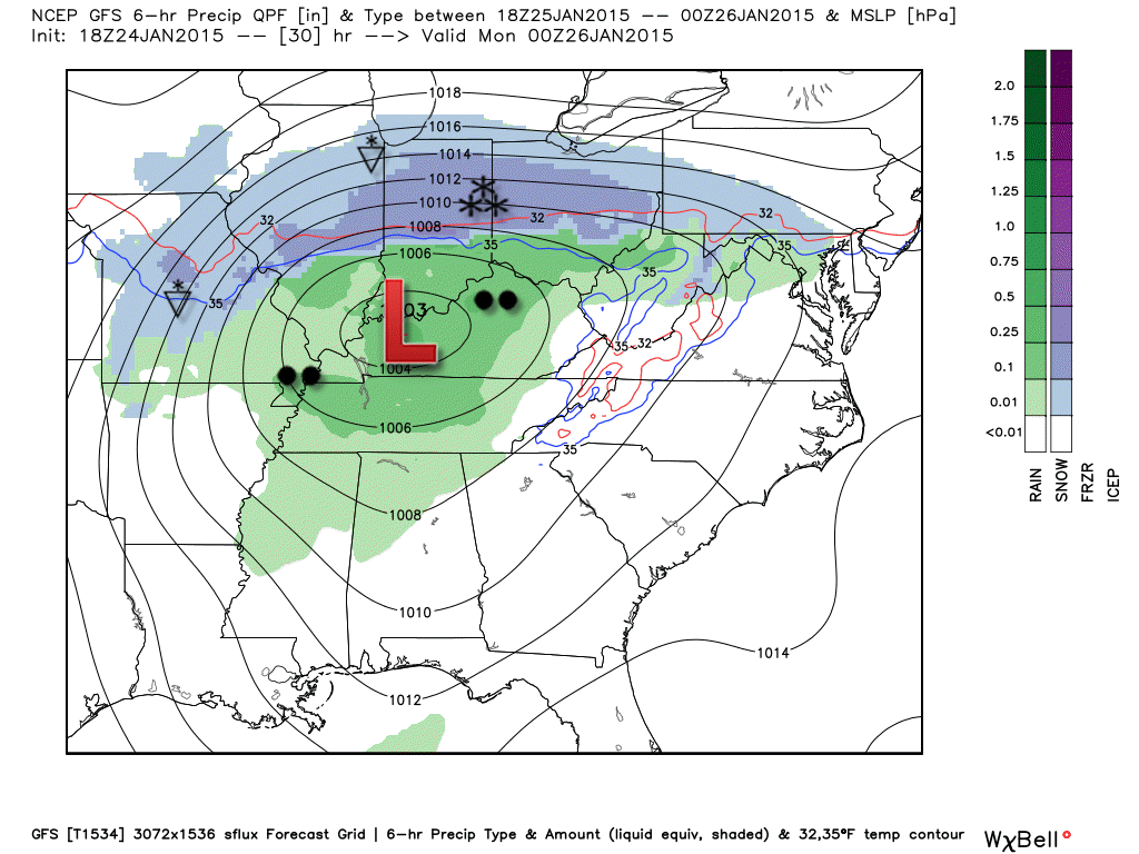
Then finally by evening – the low is pulling away. Now, as the low pulls away…cooler air filters in. We may see a brief period of snow flurries or snow showers.
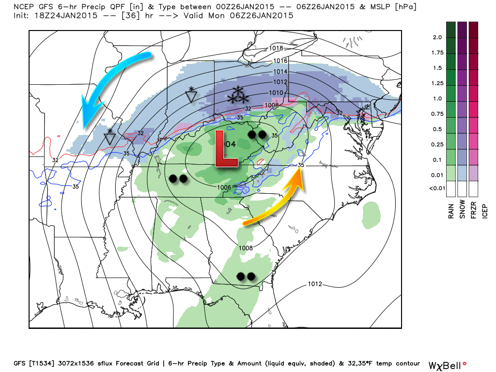
The upcoming work week will be dominated by small clippers diving down from the Northern Plains. These clippers will bring some reinforcing shots of cool air. Nothing extreme or dramatic.
What is a clipper?
Alberta clipper. An Alberta clipper (also known as a Canadian Clipper) is a fast moving low pressure area which generally affects the central provinces of Canada and parts of the Upper Midwest and Great Lakes regions of the United States.
We may see an increase in cloud cover with each clipper. One on Monday afternoon/Tuesday and one around Wednesday night/Thursday. Small chances for light rain, as well. We will have to see if temperatures are cold enough for light snow.
Here is the NAM depiction of the Monday afternoon and night system. It does show some light precipitation in our area
Watching the first week of February for some bigger/sharper cold spells. Maybe precipitation, as well. See the extended discussion below.
Hungry for Cat Fish or Bluegill? Open Sunday 11 am to 2 pm
Did you know that the Weather Observatory is funded by people like you? I rely on ad’s on this blog and individual donations. PayPal also allows you to set up a monthly recurring donation. I have had several people give $5, $10, and $20 a month. A recurring donation helps keep the weather information flowing. If you enjoy this blog, the Twitter account, the Facebook interaction, the weather radars, and all of the other information then consider making a donation or setting up a recurring donation (if you don’t use PayPal then contact me through email about how you can mail a donation) beaudodson@usawx.com
Thank you for your support!

Added a chance for a thunderstorm

The rain may end as snow showers on Sunday night/Monday morning. Will have to see if there is any moisture left on roadways. Temperatures will fall below freezing on Sunday night and Monday morning.
Check out our newest sponsors $5 meal! The DQ Grill and Chill (located across from Noble Park in Paducah, Kentucky) is the newest WeatherTalk Blog sponsor! A local business helping to sponsor the weather information that you have come to love so much.
They have a Facebook Page and I encourage you to check it out. DQ Grill and Chill on Facebook


The wild card tells you where the uncertainties are in the forecast
Wild card in this forecast – the wild card is whether or not we might see some snowflakes on Sunday night and Monday morning. At least the possibility since the low is going to track so far southwest.

Can we expect severe thunderstorms over the next 24 to 48 hours? Remember that a severe thunderstorm is defined as a thunderstorm that produces 58 mph winds or higher, quarter size hail or larger, and/or a tornado.
Thunderstorm threat level is ONE
A rumble of thunder possible today. Pea size hail possible if a thunderstorm does form.


Will I need to take action?
An umbrella on Sunday? Perhaps 🙂 with some showers around. Otherwise, will monitor for some snow showers on Sunday night as the low pulls away and colder air filters back into the region.

How much precipitation should we expect over the next few days?
A light rain event today (Sunday) into this evening. Rainfall amounts should be on the low side, unfortunately. We could use some rain. Drought conditions now prevail about parts of western Kentucky and western Tennessee.
We have a new sponsor! G&C Multi-Services out of Paducah, Kentucky. G & C Multi-Services is a service provider in Western Kentucky that provides industrial and commercial equipment fabrication, machine troubleshooting, repair and maintenance, and installation. They can custom fabricate steel, stainless, and aluminum products per customer specifications.
Visit their web-site here. Or click the ad below! They have a Facebook page and it can be viewed here.


Although I can’t make any promises…the long range outlook does have a more wintry look to it.
We do have at least a chance for some snow showers tonight (Sunday night) and tomorrow morning. This is in response to an area of low pressure pushing into the Ohio Valley. The low will pull away this evening and colder air will filter in. That may change the rain showers over to some snow showers. Right now this does not look to be a major ordeal. But, if there were some moisture left on roadways then it could freeze late tonight and Monday morning. Something to keep in mind. This will be highly dependent on there being precipitation falling as temperatures go below freezing. Road temperatures aren’t all that cold. But, bridges and overpasses always freeze first.
Will monitor and do some now-cast posts on the Facebook weather page if need be.
A little system on Tuesday might bring some rain showers or snow showers into the area. Timing of that system is a little iffy right now – late Monday night into Tuesday appears correct at this point.
The long range indicates much colder air will arrive as we push into February. Several storm systems will need to be monitored and tracked, as well. Perhaps this is the most promising pattern we have had all winter (for winter fans, that is)
No promises, of course…but we will have something to track over the coming weeks. Maybe you snow lovers will finally receive some white gold. We shall see.
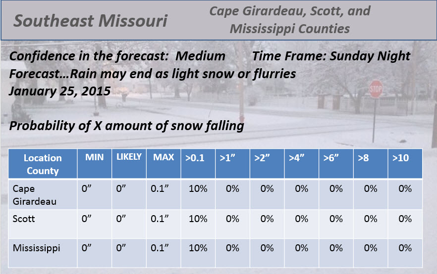
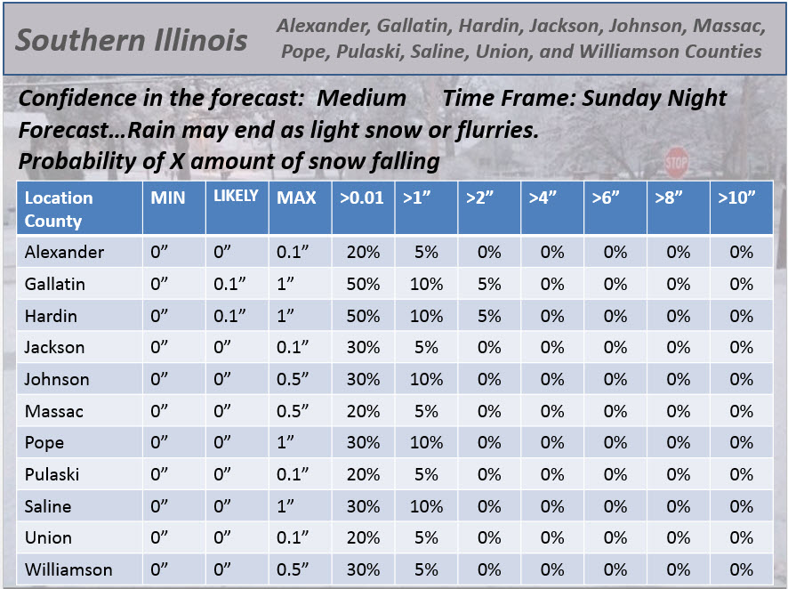
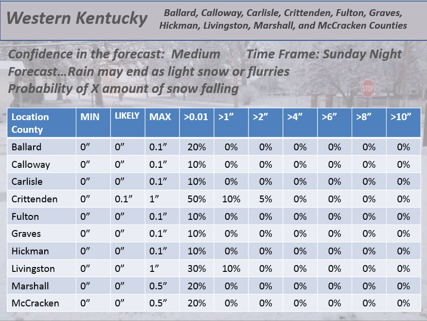
With the potential of light snow tonight…here are my snowfall probability forecasts
Southeast Missouri
Southern Illinois
Western Kentucky

This section of the blog is speculative forecast information. Because it is past the range of what meteorologists can forecast accurately, it should be considered speculation. Anything past day 5 is considered a long range forecast.
The long range part of the forecast continues to be made up of a colder pattern unfolding as we move into February.
All of the ensembles and models are pointing to a couple of sharp cold snaps as we move into the first and second week of February.
Some of the data indicates bitterly cold air – similar to what happened in early January. Of course, this is the long range part of the journal discussion. Long range forecasts are dicey, at best. Bottom line – it should be quite a bit colder as we move into February (compared to the last few weeks).
I do like the look of the pattern for cold weather. I am forecasting everything to line up for some decent shots of cold air. Now, I know what you snow lovers are wondering – WILL IT SNOW?
As always, there is no way of knowing whether one or two systems will interact with the cold air. I always remind you that cold does not equal snow. We have witnessed that during the last 4 weeks. We had plenty of cold air in early January. We did not have plenty of snow.
I am tracking 2 or 3 potential systems as we move towards February and into February. We will have to wait and see what the exact track of each system ends up being. That will determine if we might have some Milk and Cookies with Beau 🙂 scheduled anytime soon.
Keep hope alive snow lovers. The best pattern of the winter should develop soon. Maybe you will get your snow.
On another note…
We need rain. We need snow. Drought conditions are developing over the area. This is bad news. We do not want to enter spring in drought. Hopefully the overall pattern will shift. My winter forecast was for below normal precipitation and below normal temperatures. We still have another solid month to go before we can grade the forecast. The forecast runs from December through February. Meteorological spring begins on March 1st. Not too far away.
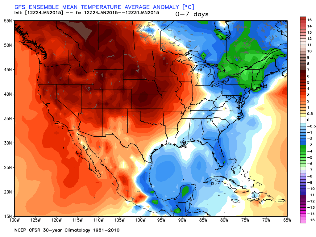
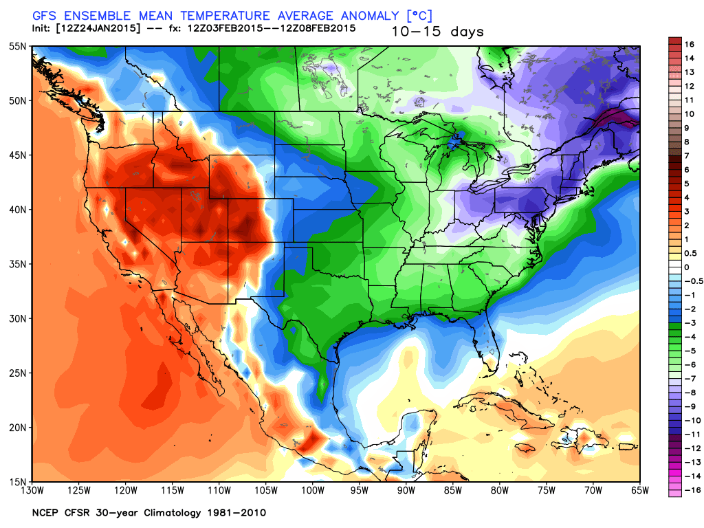
Let’s take a look at the GFS model. This is showing temperature anomalies as we push into the very last part of January into the first week or two of February. You can see the below normal anomalies get larger as we push into the long range. All signs point towards colder weather as we move into the first part of February. The potential for a couple of sharp cold snaps is on the table.
This first map is for January 24th through January 31st. You can see we border the above average temperatures and below average temperatures. Watch what happens as we move forward. Note the anomalies are in Celsius.
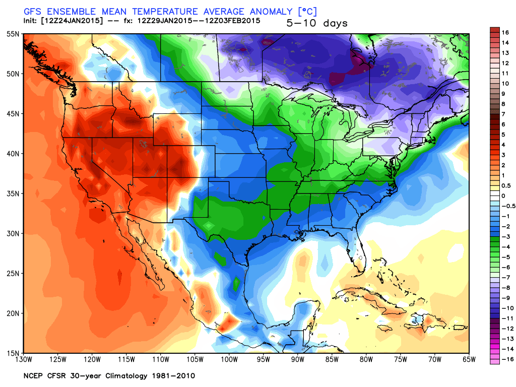
This next map covers January 29th through February 3rd. Brrr – the colder air is obviously pushing into our region. We are now in below normal temperatures.
And one last map. This is for February 3rd through February 8th. Still well below normal temperatures. The scale is on the right side of the map. Again, in Celsius.
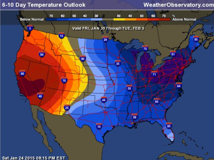
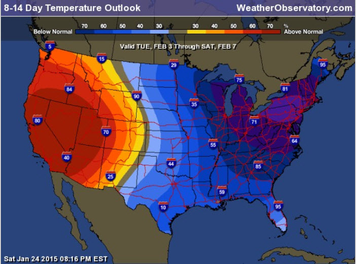
The 6-10 and 8-14 day temperature outlooks are trending colder. And, I agree.
Dates are at the top of the image
So, what does that mean for you?
It likely means a return to winter like temperatures as we push towards the end of January and especially as we move into February.

Who do you trust for your weather information and who holds them accountable?
I have studied weather in our region since the late 1970’s. I have 37 years of experience in observing our regions weather patterns. My degree is in Broadcast Meteorology from Mississippi State University and an Associate of Science (AS). I am currently working on my Bachelor’s Degree in Geoscience. Just need to finish two Spanish classes!
I am a member of the American Meteorological Society. I am a NOAA Weather-Ready Nation Ambassador. And, I am the Meteorologist for McCracken County Emergency Management.
I own and operate the Southern Illinois Weather Observatory.
There is a lot of noise on the internet. A lot of weather maps are posted without explanation. Over time you should learn who to trust for your weather information.
My forecast philosophy is simple and straight forward.
- Communicate in simple terms
- To be as accurate as possible within a reasonable time frame before an event
- Interact with you on Twitter, Facebook, and the blog
- Minimize the “hype” that you might see on television or through other weather sources
- Push you towards utilizing wall-to-wall LOCAL TV coverage during severe weather events
I am a recipient of the Mark Trail Award, WPSD Six Who Make A Difference Award, Kentucky Colonel, and the Caesar J. Fiamma” Award from the American Red Cross. In 2009 I was presented with the Kentucky Office of Highway Safety Award. I was recognized by the Kentucky House of Representatives for my service to the State of Kentucky leading up to several winter storms and severe weather outbreaks.
If you click on the image below you can read the Kentucky House of Representatives Resolution.

I am also President of the Shadow Angel Foundation which serves portions of western Kentucky and southern Illinois.

We have regional radars and local city radars – if a radar does not seem to be updating then try another one. Occasional browsers need their cache cleared. You may also try restarting your browser. That usually fixes the problem. Occasionally we do have a radar go down. That is why I have duplicates. Thus, if one fails then try another one.
If you have any problems then please send me an email beaudodson@usawx.com
WEATHER RADAR PAGE – Click here —
We also have a new national interactive radar – you can view that radar by clicking here.
Local interactive city radars include St Louis, Mt Vernon, Evansville, Poplar Bluff, Cape Girardeau, Marion, Paducah, Hopkinsville, Memphis, Nashville, Dyersburg, and all of eastern Kentucky – these are interactive radars. Local city radars – click here

Here is the official 6-10 day and 8-14 day temperature and precipitation outlook. Check the date stamp at the top of each image (so you understand the time frame).
The forecast maps below are issued by the Weather Prediction Center (NOAA).


The latest 8-14 day temperature and precipitation outlook. Note the dates are at the top of the image. These maps DO NOT tell you how high or low temperatures or precipitation will be. They simply give you the probability as to whether temperatures or precipitation will be above or below normal.


Many of my graphics are from www.weatherbell.com – a great resource for weather data, model data, and more


This blog was inspired by ABC 33/40’s Alabama Weather Blog – view their blog
Current tower cam view from the Weather Observatory- Click here for all cameras.

Southern Illinois Weather Observatory

The Weather Observatory

Southern Illinois Weather Observatory
WSIL TV 3 has a number of tower cameras. Click here for their tower camera page & Illinois Road Conditions

Marion, Illinois
WPSD TV 6 has a number of tower cameras. Click here for their tower camera page & Kentucky Road Conditions & Kentucky Highway and Interstate Cameras

Downtown Paducah, Kentucky
Benton, Kentucky Tower Camera – Click here for full view

Benton, Kentucky

I24 Paducah, Kentucky

I24 Mile Point 9 – Paducah, KY

I24 – Mile Point 3 Paducah, Kentucky

You can sign up for my AWARE email by clicking here I typically send out AWARE emails before severe weather, winter storms, or other active weather situations. I do not email watches or warnings. The emails are a basic “heads up” concerning incoming weather conditions.