
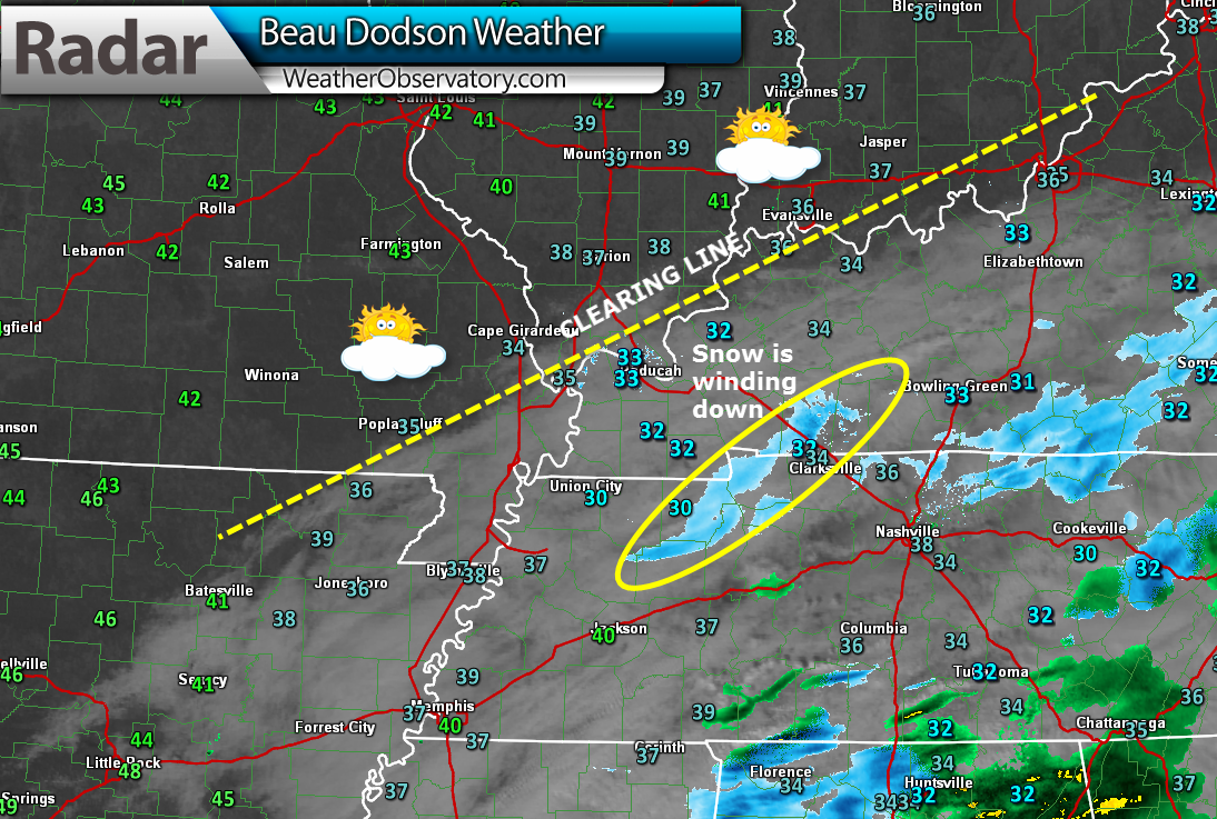
1 PM Update – snow is exciting the area. Road conditions will improve over the coming hours as temperatures continue to rise. The yellow line is the clearing line. Temperatures have risen into the 40’s over parts of southeast MO and southern IL.
8 AM – updated all information to enhance wording on the ongoing snow over western Kentucky.
We have our first sponsor for the blog. Milner and Orr Funeral Home and Cremation Services located in Paducah, Kentucky and three other western Kentucky towns – at Milner and Orr they believe in families helping families.
![]()

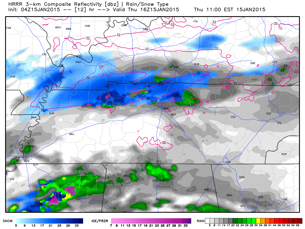
This forecast update covers far southern Illinois, far southeast Missouri, and far western Kentucky. See the coverage map on the right side of the blog.
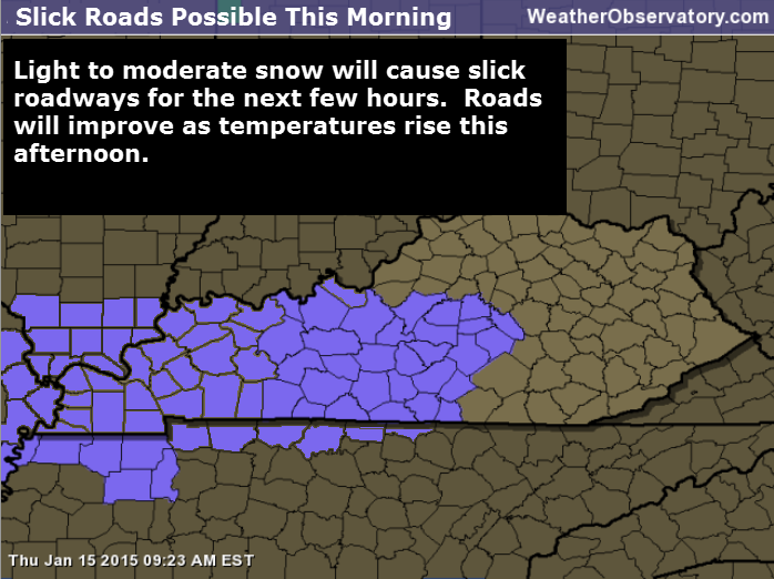
Thursday – Hazardous roads this morning – Snow. Moderate snow at times. Accumulations from a dusting to 1″-3″ where snow persists. Very hazardous road conditions likely in areas that receive persistent snow. High temperatures in the middle to upper 30’s. West/southwest winds at 5-10 mph.
Area of hazardous road conditions can be seen on this map below.
No official National Weather Service advisory, but roads are going to be ice covered in areas where snow persists for a few hours. A lot of roads were not treated. That means conditions will be worse than during a normal winter weather event.
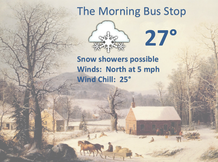
Morning School Bus Stop Weather – A chance for snow. Temperatures in the upper 20’s to lower 30’s. West winds at 5 mph.
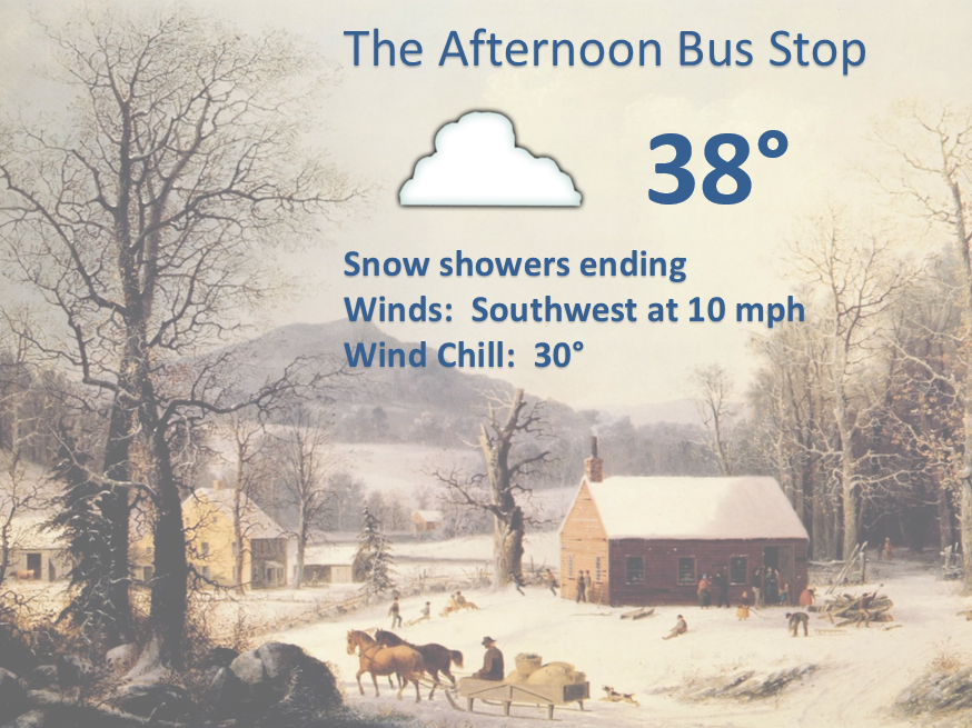
Afternoon School Bus Stop Weather – Cloudy and chilly. Temperatures in the upper 30’s. Southwest winds at 5-10 mph.
Thursday night – Partly cloudy. Not quite as cold as recent nights. Low temperatures in the middle 20’s. West winds at 5 mph.
Friday – Partly sunny. Temperatures will rise into the middle to upper 40’s! This will feel nice after our recent cold snap. Southwest winds at 5-10 mph.
Friday night – Mostly clear. Not as cold as recent nights. Low temperatures in the 30’s. Southwest winds at 5-10 mph.
Saturday – Warmer! High temperatures will be in the upper 40’s to middle 50’s. Team warmth will like this forecast. Southwest winds at 10 mph.
Saturday Night – Cloudy with a slight chance for a rain shower. Low temperatures in the middle to upper 30’s.
Sunday – Cooler and partly cloudy. Highs in the 40’s.

Current Temperatures Around The Local Area


An explanation of what is happening in the atmosphere over the coming days.
A winter weather precipitation system is pushing through our region this morning. This has sparked a band of light snow over southern Missouri. This band of snow is going to push through southern Illinois and parts of western Kentucky this morning.
The band of snow is narrow. That means that the area of accumulating snow will only be a few counties wide. Where the band of snow is most intense we can expect 1″-2″ of snow. This should be over parts of southeast Missouri and southern Illinois.
There is a second disturbance moving over our southern counties – this will produce a second area of snow over western Kentucky and far southern Illinois.
Where snow persists there could be a dusting to 1″-3″ of snow. Very hazardous roads will be possible where snow persists. Especially on untreated roadways.
Here is the future-cast radar showing that second streak of precipitation over our southern counties. Hmmm – this band appears to stick around the KY/TN border counties for awhile. Will have to see how much snow it can produce, if it does indeed develop as expected.
Occasionally a system like this will have a very small band of heavier totals. Isolated pockets of heavier amounts.
Not overly confident on snowfall accumulation totals. Small band – narrow band – quick mover.
Temperatures are forecast to rise above freezing by late morning and early afternoon.
Road and surface temperatures are cold. That means that snow should accumulate on untreated roadways. Some hazardous driving conditions will occur where snow accumulates. Again, mostly on untreated roadways.
If roads become hazardous then schools should consider that temperatures will rise above freezing later this morning and early afternoon. Roads should clear up at that time.
Friday will be dry and a bit milder. Saturday will be the mildest day of the next four days. Crossing fingers that we reach 50 or above on Saturday afternoon. Go team warmth.
I have regional radars and local city radars – if a radar does not seem to be updating then try another one. Occasional browsers need their cache cleared. You may also try restarting your browser. That usually fixes the problem. Occasionally we do have a radar go down. That is why I have duplicates. Thus, if one fails then try another one.
WEATHER RADAR – Click here —
Your photograph for today…
Photograph by Alexey Kljatov
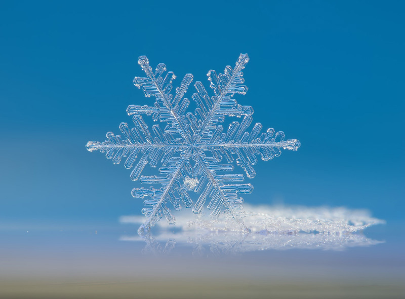
Photograph by Alexey Kljatov – we see a solitary snowflake standing on its edge on a DVD-R disk. On Flickr, Kljatov explains: “I transferred both [snow crystals] with small paintbrush. More photograph
——————————————————————————————————–
Did you know that the Weather Observatory is funded by people like you? I rely on ad’s on this blog and individual donations. PayPal also allows you to set up a monthly donation. I have had several people give $5, $10, and $20 a month. A recurring donation helps keep the weather information flowing. If you enjoy this blog, the Twitter account, the Facebook interaction, the weather radars, and all of the other information then consider making a donation or setting up a recurring donation (if you don’t use PayPal then contact me through email about how you can mail your donation) beaudodson@usawx.com Thank you!

We have a new spot that will appear on the blog from time to time – Ask The Weatherman
Mrs. Tiffany Blazina (Curriculum Coach – Middle School and High School) contacted me about answering some questions from some of the students from the Crittenden County Middle School in Marion, Kentucky. Home of the Rockets!
Mrs. Mattea Meadows, Language Arts teacher, led this project and is teaching the class about meteorology. They sent me a few questions. I will try to get to them over the coming week or two. Don’t expect the rest of the questions to have such an in-depth answer! This one was quite personal and I have a lot of information to share.

This question is from Hannah Bell:
Was there an event in your life that initially interested you in meteorology?
Thanks, Hannah for the question. As a matter of fact, yes – there were some events that helped spark my interest in meteorology. They were snowstorms. I suppose this is why I love snow so much.
I grew up on a family farm located in Massac County, Illinois. Perhaps you have been to the area? Metropolis, Illinois is the largest town in Massac County. Home of Superman! Each year the town has a celebration for Superman and other comic book heroes. I am guessing some of you have visited the celebration.
I lived on the farm with my great grandfather, grandmother, mom, dad, and two sisters. My grandmother’s house was located about 400′ to the east of the house I grew up in.
Growing up on this farm gave me a unique opportunity to view incoming weather. I lived on a hill. We did not have a lot of trees on the farm. Our house was surrounded by corn fields. Since there were not many trees, no matter what direction the storms came from I could see them. I was a weather watcher from a very young age! I have been interested in weather since I was 7 or 8 years old.
We had a lot of winter storms when I was growing up. We also had a lot of severe thunderstorms and tornadic weather. I can remember several storms that blew trees down, damaged our barns, and put the scare in us. We also had some impressive hail storms.
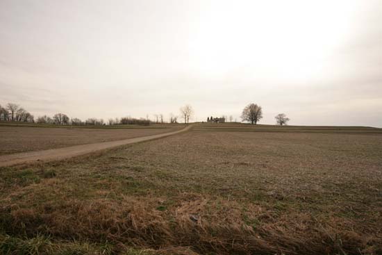
Here are some photos from the family farm. You can see that I had a great view to watch the weather.
This is an old photograph of the farm. You can just barely see the house that I grew up in. Notice all of the great sky views? My grandmother’s house also used to be on this farm. It was to the left of the house in the photograph. That house had to be demolished back in the late 1990’s. It was around 100 years old. It weathered a lot of storms…including one tornado.
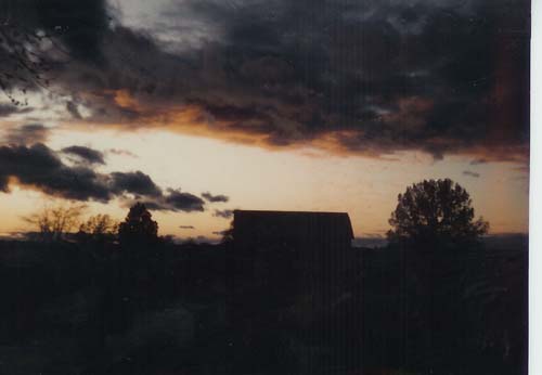
This was my view looking west (above photograph). In the middle of that photograph is a pony barn. I used to climb up in the hayloft of the pony barn and watch the storms to the south. This photo was taken at sunset. When I looked west I could see all the clouds moving towards the farm. I could watch the thunderstorms roll in…lightning, thunder, and heavy rain. No matter what the weather, I could see it coming!
My mother grew up on this same farm. She must have loved the snow, as well. My grandmother gave me these photographs of my mother playing in the snow. This was back in the 1940’s and 1950’s. That is my grandmothers house in the background.
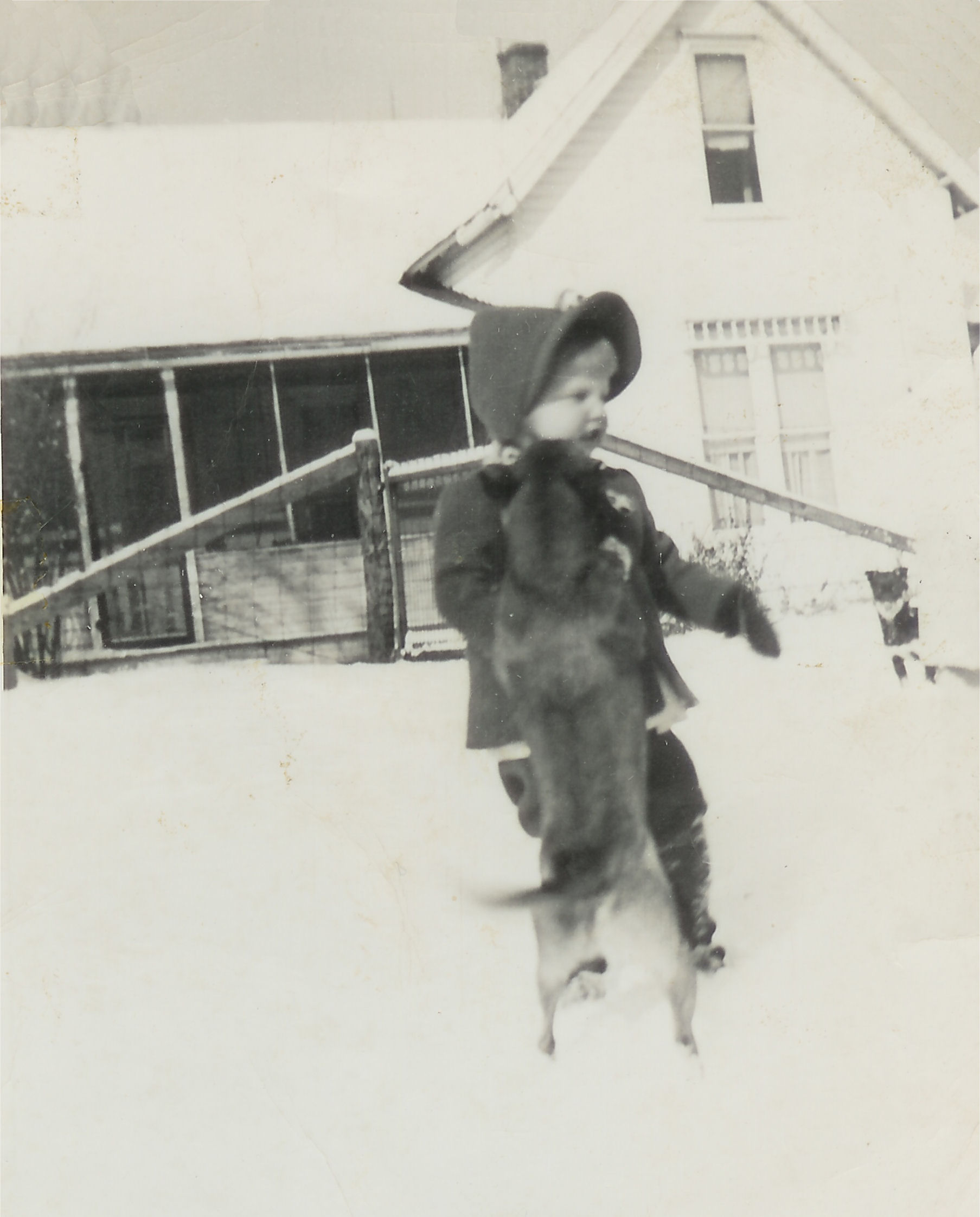
This is my mother when she was just a little girl. She loved dogs. You can see one of her pet dogs jumping up on her – playing in the snow.
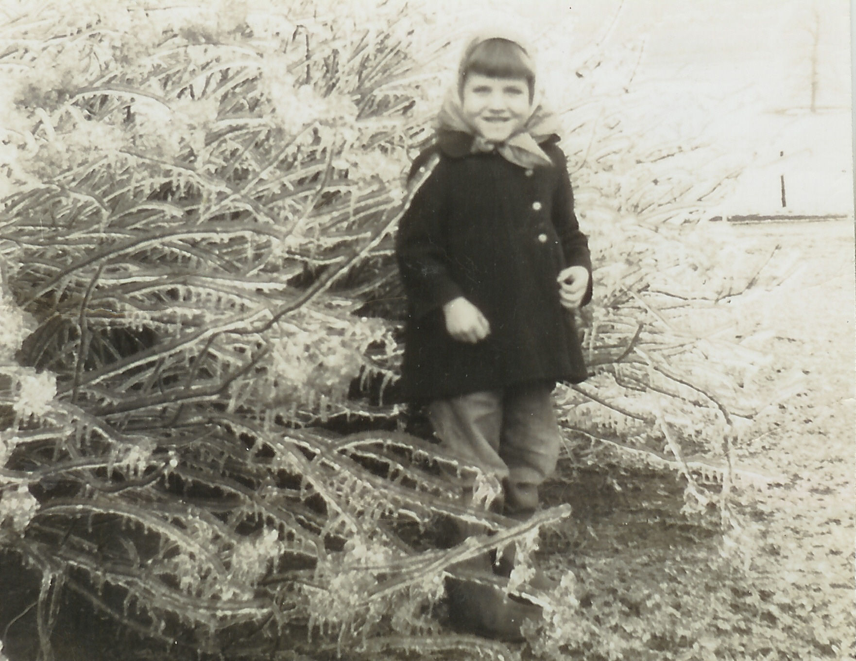
Do any of you remember the ice storms in 2008 or 2009? Well, my mother had an ice storm when she was a little girl. You can see the ice hanging off of the bushes.
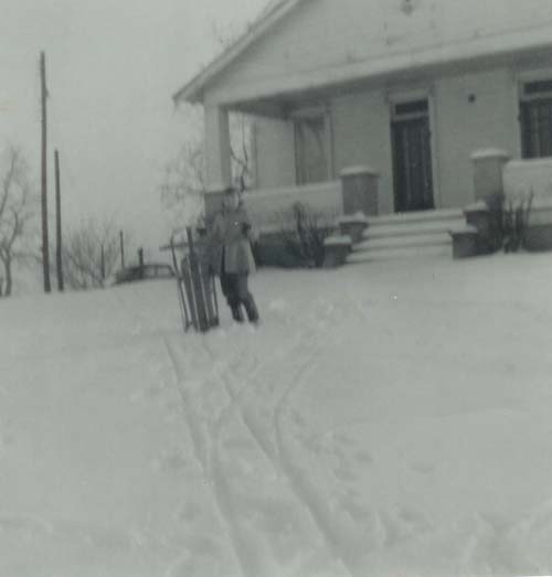
This is my mom when she was a teenager. Even then she enjoyed playing in the snow. That is my grandmothers house in the background.
Now, back to how I became interested in weather…
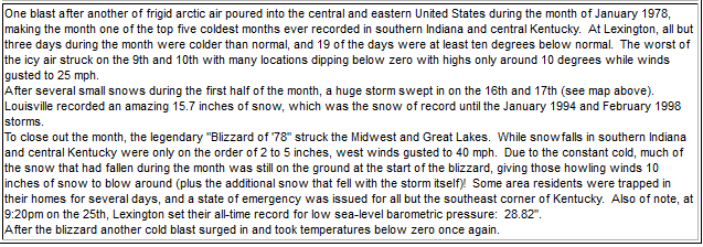
During the late 1970’s, when I was 8 and 9 years old, we had a series of winter storms. These were not just any ordinary winter storms…they were nearly blizzards. Winds would gust above 50 mph with blowing and drifting snow. Schools were closed for more than a week. Remember last year when you had day after day of snow and school closings? Well, that is the kind of winters we had back in the late 1970’s. It was heaven for snow lovers.
In particular I remember one winter storm, on January 16th, that was forecast to bring rain to our local area (by some meteorologists). The rain never did arrive. It was snow. Lots and lots of snow.
On January 16, 1978…snow had been falling on and off during the day, but snow increased quite a bit during the night. I remember sitting by the window and watching the snow fall and the wind pick up. My mother was in my sisters bedroom reading her a bedtime story. I would go back and forth and give her a weather update. I let her know the snow drifts were growing deeper and deeper in front of the house. I was excited to see all of the snow. I am guessing, on that night, my mom had a hard time getting me to go to sleep.
The wind was howling. I remember feeling the cold air filtering through the window sill. I can also remember the wind whistling through the front door. We had double doors on the front of the house. These doors faced towards the north. When north winds would blow we could hear the wind whistling.
Don McNeely, a local meteorologist from CBS KFVS Channel 12, kept interrupting the television shows and talking about how the rain was not developing as expected. He was forecasting more and more snow. The snow totals kept going up. Back then I always watched Don McNeely. He was a great meteorologist and had been forecasting weather in our region for decades.
By the time I went to bed the snowdrifts in front of the house were over 2′ tall. The driveway was completely snow covered. I knew we would not be having school for awhile!
Morning light brought a winter wonderland. I looked out my window and saw the entire landscape covered in deep snow. The deepest snow of my childhood. The drifts were measured in feet. I would hide behind some of the snow drifts and my grandmother couldn’t see me. It made for a great game of hide and seek. She enjoyed snow just as much as me. She would make us snow cream. Have any of you ever had snow cream? Nobody made snow cream like my grandmother!
Temperatures after this snowstorm were bitterly cold. Well below zero.
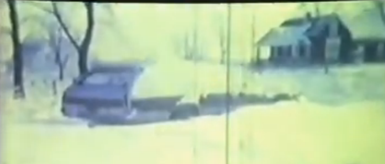
Here are some screen grabs from the video below. You can see my two sisters in this first photo.
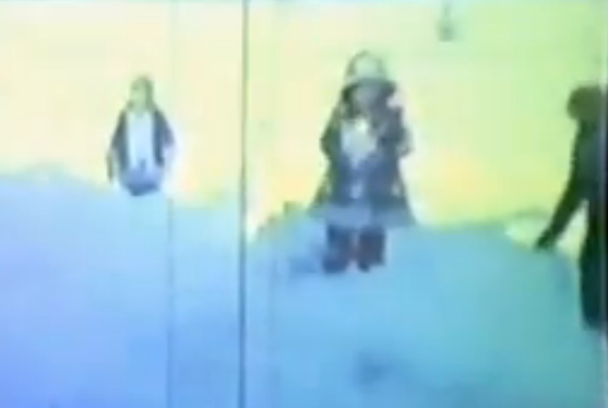
Drifts were up to the hood on the station wagon
This is Marvin Korte – plowing our driveway
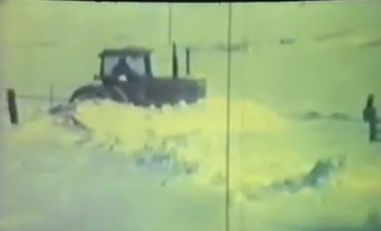
My mother took this video of us playing in the snow. This was in our front yard. We had a blast playing in the snow. One of our neighbors, Marvin Korte, had to plow our driveway. You can see how deep the snow is when he pushes it out of the way. That is a LOT of snow! YouTube video below.
How did this winter storm develop?
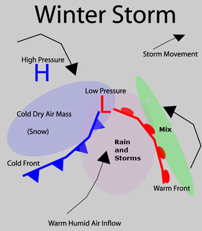
An area of low pressure developed over Texas and moved northeast towards our region. During the winter months you want the low to pass to your south in order to receive significant snow. This is because low pressure rotates counterclockwise. The colder air is typically found to the north of the low. Warmer air is found to the south and southeast of the low. Let me show you an illustration of how a typical winter storm looks on a weather map.
On this map illustration (below) you will see the blue H – that is high pressure. The red L is the low pressure. Typically during the winter months high pressure will bring cold air into our region. An area of low pressure usually brings clouds, rain, or snow.
You can also see the warm front (the red line with half circles). Along and north of the warm front you typically experience freezing rain, sleet, and snow. Once the warm front moves north of your location you usually see the wintry precipitation turn to rain. This is one reason we call it a warm front. When it passes your location the temperature normally rises.
The cold front is the blue line with blue half circles.
Notice that the colder air is to the north and west of the area of low pressure. This is where you want to be located in order to experience the heaviest snow.
Let’s take a look at the weather map from January 16, 1978 and January 17, 1978.
Click on the maps for a larger view.
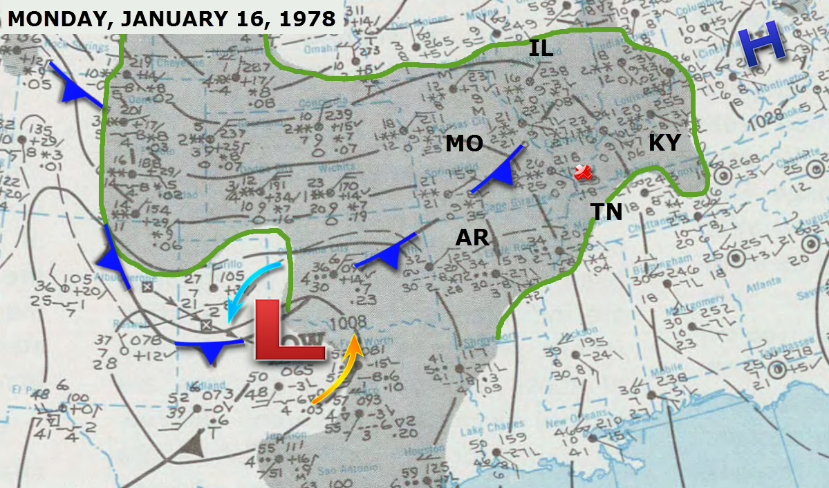
Can you find the area of low pressure on this first map? This map was from the morning of January 16th.
The area of low pressure is centered over northeast Texas. I know the state lines are difficult to see. I have marked where MO (Missouri), Illinois, Kentucky, Tennessee, and Arkansas are located. See that tiny red X over western Kentucky? That is Paducah.
The dark gray shaded area (which I outlined in green) is where snow or freezing rain was falling on Monday, January 16th. At the time this map was issued, Paducah, Kentucky had a temperature of 26 degrees. Snow was falling. You can see that information by looking just to the left of the tiny red X. That is a METAR station located near Cairo, IL and Paducah, KY. See the two tiny snowflakes? That indicates snow was falling. Above the two tiny snowflakes is the number 26. That indicates the temperature. The wind barb is pointing towards the southeast. Winds were from the southeast at 10 knots.
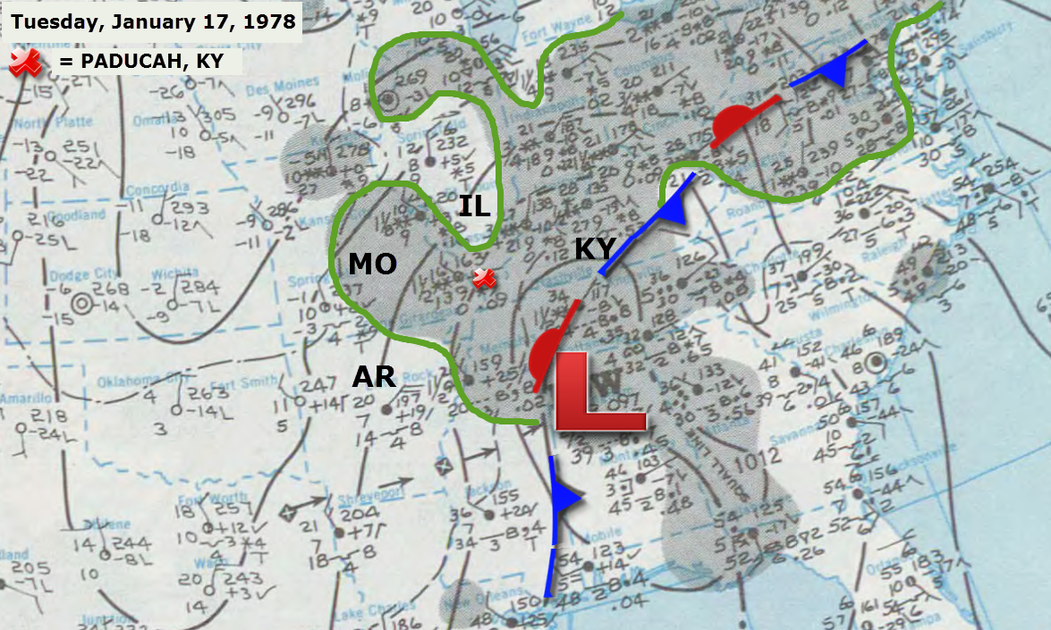
Let’s take a look at the weather map on January 17, 1978 (below). The storm system has moved east/northeast into the Tennessee Valley. Again, click on the map for a larger view.
Earlier I told you that in order to pick up the heaviest snow you want to be north of the area of low pressure. The low is centered in northern Alabama on this map. That places our region in the best zone for heavy snow. And heavy snow did fall! Paducah, Kentucky received between 10″-12″ of snow. Parts of far southern Illinois picked up more than 12″ of snow.
At 7 am on January 17th, the METAR station near Paducah, Kentucky shows that the temperature was 16 degrees with snow falling. It also shows northwest winds at 10-15 knots.
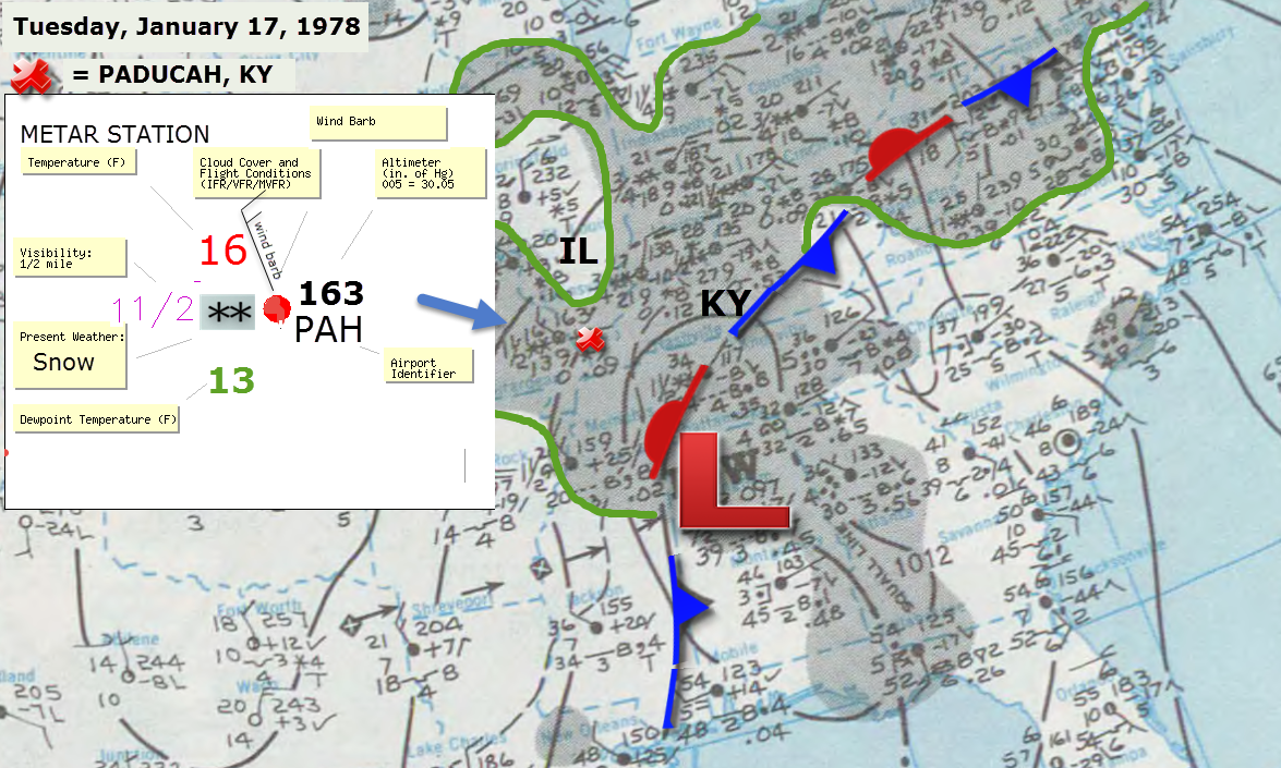
What is a METAR station?
METAR is a format for reporting weather information. A typical METAR contains data for the temperature, dew point, wind speed and direction, precipitation, cloud cover and heights, visibility, and barometric pressure. All of the little numbers on this map are METAR stations. Different cities – different weather conditions.
Let me show you an example of a METAR station report. Again, a METAR station report gives you the weather conditions for a specific town. These are typically used by pilots and meteorologists. You can find them dotted all over the weather map above. Each number and symbol has a meaning. Let’s take a closer look at the report from Paducah, Kentucky on the morning of January 17, 1978.
You can see that the temperature was 16 degrees. The dew point was 13 degrees. The winds were from the northwest at 15 knots. It was snowing and visibility was 1 1/2 miles. The filled red circle means that it was cloudy/overcast.
The PAH stands for Paducah, Kentucky.
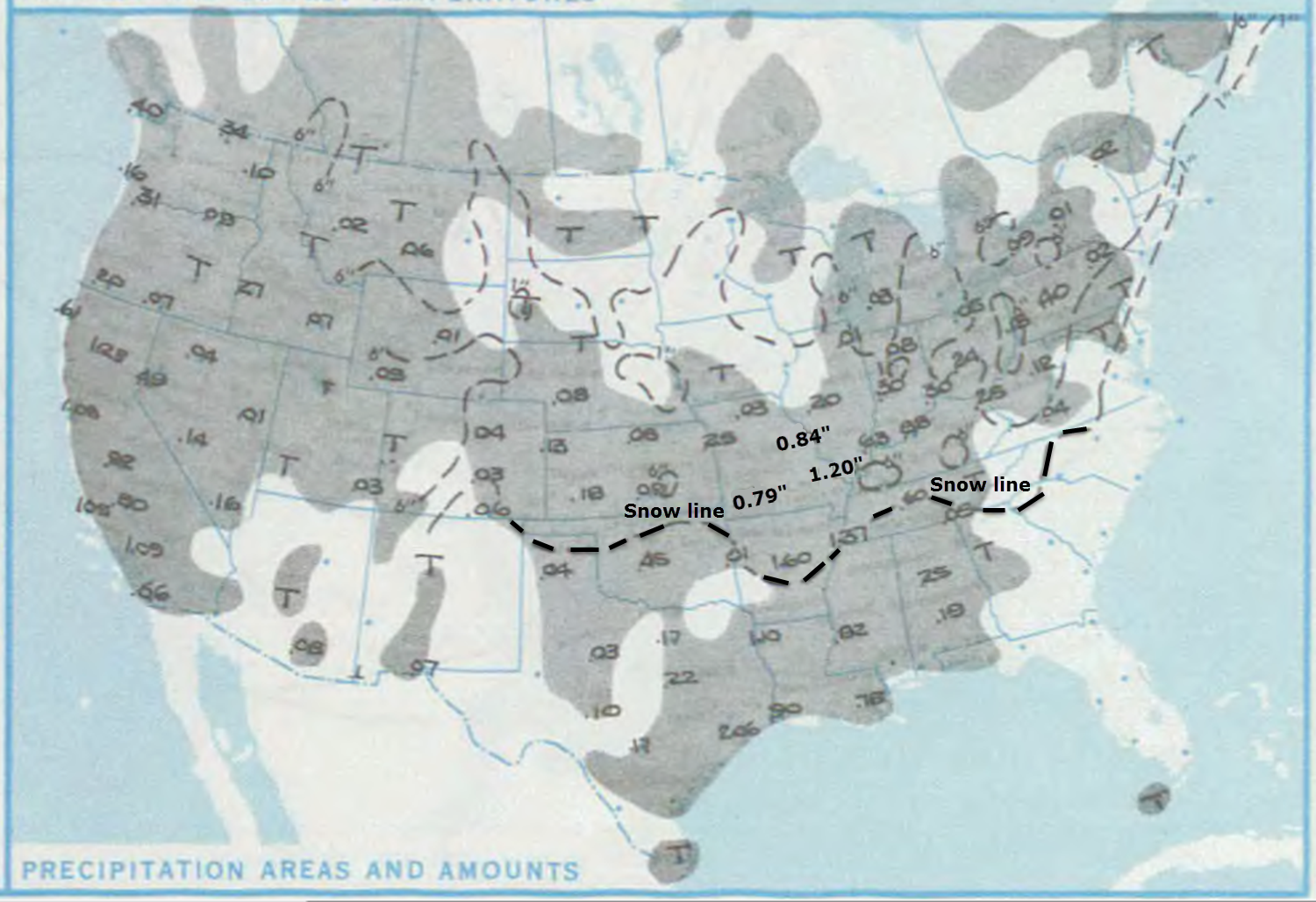
This storm system dropped a large amount of snow and rain over much of the United States. Here is the precipitation totals map (below). These numbers represent the liquid totals. Do you see the 1.20″ near Paducah, Kentucky? That is how much precipitation fell (if you melted the snow it would equal 1.20″).
The dotted black line represents the freezing line (32° or below). Anything north of that line would have been snow, sleet, and freezing rain. South of that line would have been rain.
Normally we use a 10:1 ratio formula for forecasting snowfall amounts. That means that 1″ of rain equals 10″ of snow. If you put 10″ of snow in your rain gauge and melted it down it would equal 1″ of water.
Paducah measured around 10″-12″ of snow. That means the 10:1 ratio formula would have worked fairly well for this particular event. 10″-12″ of snow would equal 1.20″ of water.
Here is a snowfall map from the Louisville, Kentucky National Weather Service Office. Portions of their forecast area received over 14 inches of snow. This was a memorable snowstorm for much of the region.
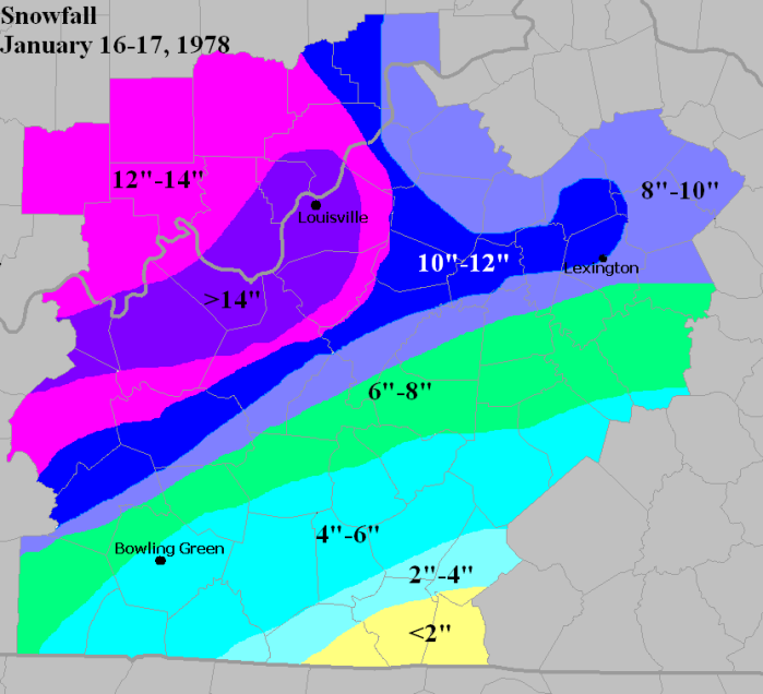
Here is a report by the Louisville, Kentucky National Weather Service
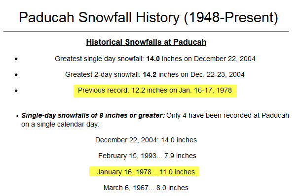
This storm is still recorded in the record books of the Paducah, Kentucky National Weather Service
And that is one reason I am interested in meteorology. The big winter storms of the late 1970s.
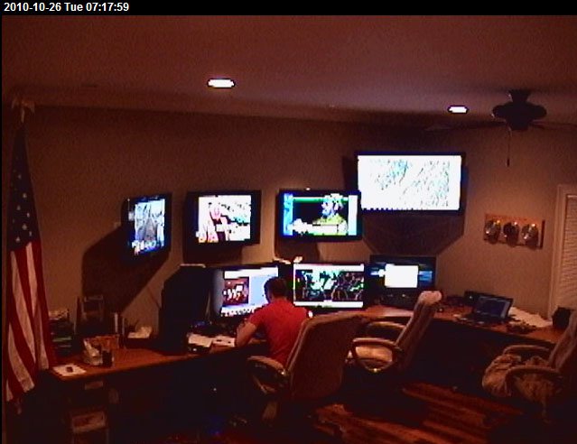
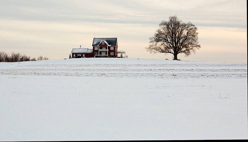
Here are some more photographs of snow up at the very same farm! This is where I built the Weather Observatory in 2008.
When you read my weather forecasts – this is where I am typing them from. This is my weather room. During severe weather or winter storms this room is very busy.
Remember the first photograph I showed you? The one with the house I grew up in. Well, this is about the same view but looking up at the house I now live in. You can see the big oak tree is still there to the right of the house. This photograph was taken last winter.
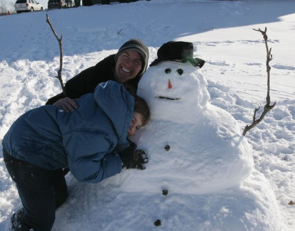
My nephew, Tyler, also likes snow. We built this snowman a few years ago after a heavy snow.
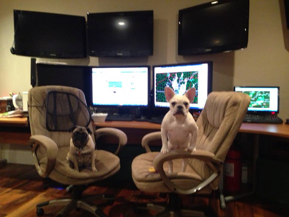
Of course I don’t forecast alone. Daisy (pug on the left) and Scooter (French bulldog on the right) are always there to help me out.
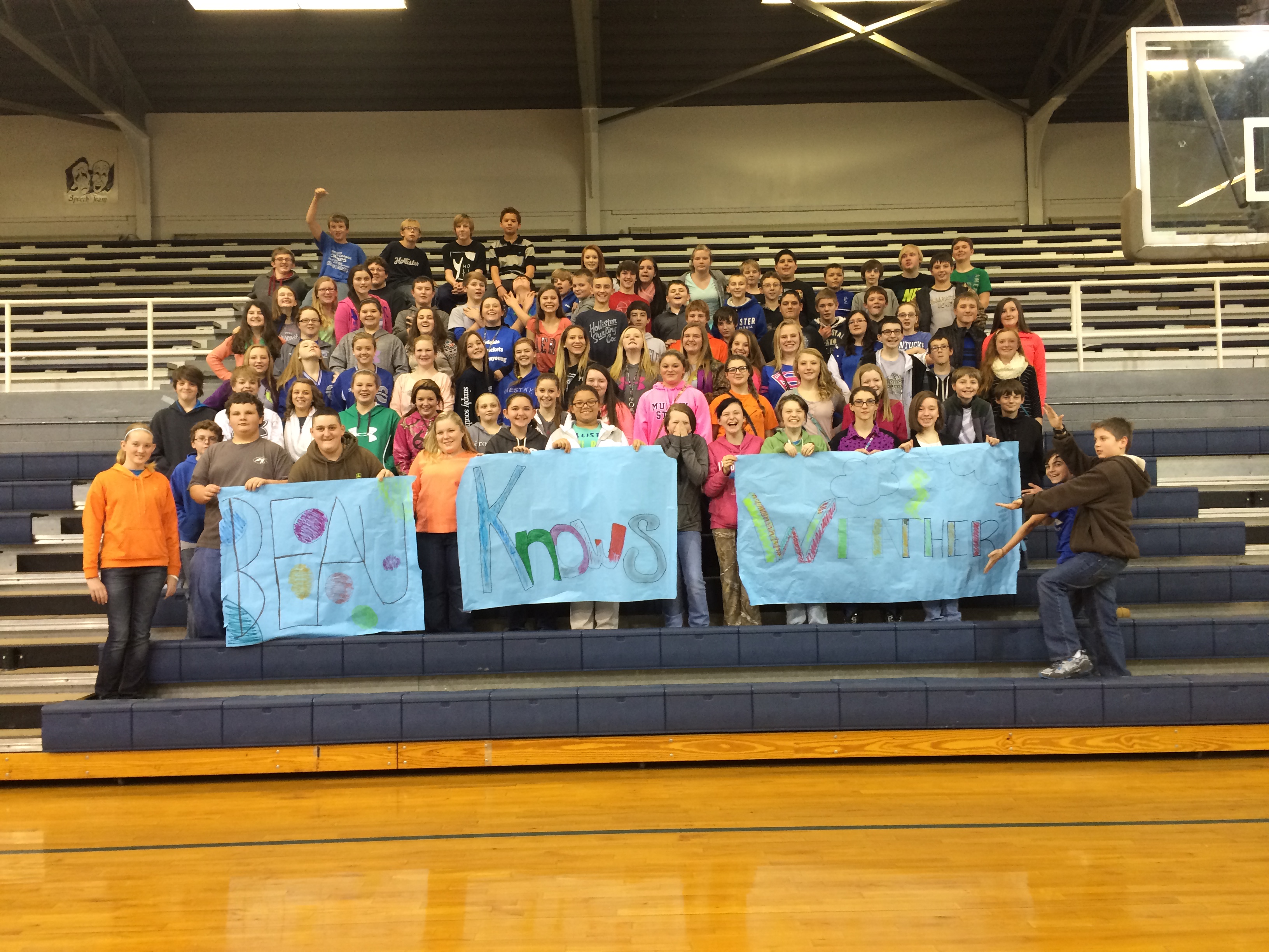
Thanks for the class photograph!
Click photo for a larger view.
7th grade class of the Crittenden County Middle School located in Marion, Kentucky.

Biggest change over the past 24 hours was to increase the chance for snow today. Otherwise, I did increase temps a bit for Saturday. I am guessing nobody is going to complain about that subject.

Concerns this morning center around the snow in the area. Some slick roads will be possible in areas where the snow persists for a few hours. Ground conditions are cold. Snow should stick.
Temperatures will rise above freezing later this morning (in areas that aren’t above freezing).
Check out our newest sponsors $5 meal deal! The DQ Grill and Chill (located across from Noble Park in Paducah, Kentucky) is the newest WeatherTalk Blog sponsor! A local business helping to sponsor the weather information that you have come to love so much.
They also have a Facebook Page and I encourage you to check it out. DQ Grill and Chill on Facebook


The wild card tells you where the most uncertainty is in the current forecast.
Wild card in this forecast – wild card today is centered around the narrow band of snow pushing through the area. This quick moving system should produce a small band of accumulating snow across our region. This should be centered on southeast Missouri and southern Illinois. A second area of snow over western Kentucky will also cause problems.
A dusting to 1-3″ of snow appears possible.

Can we expect severe thunderstorms over the next 24 to 48 hours? Remember that a severe thunderstorm is defined as a thunderstorm that produces 58 mph winds or higher, quarter size hail or larger, and/or a tornado.
Thunderstorm threat level is ZERO


Will I need to take action?
Areas with snow may have some slick roadways. Check the latest radar to see where the snow is located.
I have regional radars and local city radars – if a radar does not seem to be updating then try another one. Occasional browsers need their cache cleared. You may also try restarting your browser. That usually fixes the problem. Occasionally we do have a radar go down. That is why I have duplicates. Thus, if one fails then try another one.
WEATHER RADAR – Click here –

How much rain should this system produce over our region?
Snow this morning. A dusting up to 1″-3″
Chance for some light rain on Saturday night as a front pushes through the area.
We have a new sponsor for WeatherTalk! G&C Multi-Services out of Paducah, Kentucky. G & C Multi-Services is a service provider in Western Kentucky that provides industrial and commercial equipment fabrication, machine troubleshooting, repair and maintenance, and installation. They can custom fabricate steel, stainless, and aluminum products per customer specifications.
Visit their web-site here. Or click the ad below! They have a Facebook page and it can be viewed here.


This mornings light snow will come to an end by the afternoon hours. Expect a dusting to an inch or two of snow across parts of the area. Best chance of this happening would be over parts of southeast Missouri and southern Illinois. Western Kentucky may see a dusting or so in spots.
The heaviest band of snow will produce 1″-3″ of snow.
Here are the active warnings – click down to view your particular county


In the long range I continue to monitor a system for next week. Several disturbances should move through our region. The first one will be early in the week and the second one will be towards Wednesday-Friday. The second one appears to be a stronger system.
The exact track and intensity of the system will determine what happens in our local region. Some of the data has trended colder with a more southerly track for the area of low pressure. Remember that when the low tracks to our south we typically have colder air in our region.
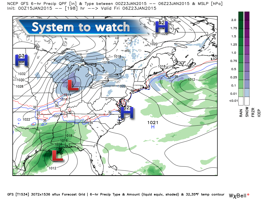
Here is the GFS depiction of that system – image from www.weatherbell.com
You can see one system to our north and one to our south. Will these systems phase somewhere over our region or the East Coast? Will it? Won’t it? Rain? Snow?
Let’s keep on watching.
The pattern may reload as we head into late January and February. That would mean colder temperatures and perhaps a more active storm track. This would be in response to the Arctic Oscillation (AO) going negative. That might mean a stormier pattern as blocking occurs way to our north and east. Systems get blocked and that means they can’t just skirt off to our south and east. They would develop and move northeast into the Ohio and Tennessee Valley. When that happens our weather becomes more interesting. We shall see if that happens.
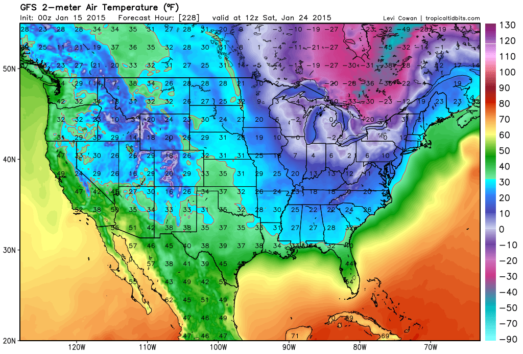
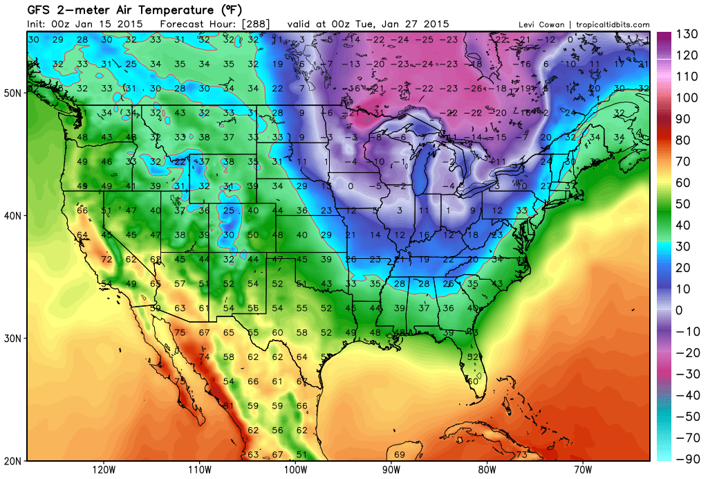
Here are a couple of temperatures map from the GFS model (very long range – we call that lala land in the forecasting business)
You can see it is picking up on a couple of cold shots
This first one is for Saturday, January 24th (this is behind the potential storm system next week). The model is showing the cold air in response to the big storm on the East Coast. Storm pulls away and cold air dumps in behind it.
And another shot of cold air behind that one – this map is for January 27th. Not that this is exactly what will happen (models don’t do well past day 5). But, the overall idea is that the end of January will see more cold shots.

Please visit your local National Weather Service Office by clicking here. The National Weather Service Office, for our region, is located in Paducah, Kentucky. They have a lot of maps and information on their site. Local people…local forecasters who care about our region.

We have regional radars and local city radars – if a radar does not seem to be updating then try another one. Occasional browsers need their cache cleared. You may also try restarting your browser. That usually fixes the problem. Occasionally we do have a radar go down. That is why I have duplicates. Thus, if one fails then try another one.
If you have any problems then please send me an email beaudodson@usawx.com
WEATHER RADAR PAGE – Click here —
We also have a new national interactive radar – you can view that radar by clicking here.
Local interactive city radars include St Louis, Mt Vernon, Evansville, Poplar Bluff, Cape Girardeau, Marion, Paducah, Hopkinsville, Memphis, Nashville, Dyersburg, and all of eastern Kentucky – these are interactive radars. Local city radars – click here
NOTE: Occasionally you will see ground clutter on the radar (these are false echoes). Normally they show up close to the radar sites – including Paducah.

Regional Radar – Click on radar to take you our full radar page.


Regional Radar
![]()
Current WARNINGS (a warning means take action now). Click on your county to drill down to the latest warning information. Keep in mind that there can be a 2-3 minute delay in the updated warning information.
I strongly encourage you to use a NOAA Weather Radio or warning cell phone app for the most up to date warning information. Nothing is faster than a NOAA weather radio.


Color shaded counties are under some type of watch, warning, advisory, or special weather statement. Click your county to view the latest information.

Missouri Warnings

Illinois Warnings

Kentucky Warnings
Please visit your local National Weather Service Office by clicking here. The National Weather Service Office, for our region, is located in Paducah, Kentucky.
Many of my graphics are from www.weatherbell.com – a great resource for weather data, model data, and more


This blog was inspired by ABC 33/40’s Alabama Weather Blog – view their blog
Current tower cam view from the Weather Observatory- Click here for all cameras.

Southern Illinois Weather Observatory

The Weather Observatory

Southern Illinois Weather Observatory
WSIL TV 3 has a number of tower cameras. Click here for their tower camera page & Illinois Road Conditions

Marion, Illinois
WPSD TV 6 has a number of tower cameras. Click here for their tower camera page & Kentucky Road Conditions & Kentucky Highway and Interstate Cameras

Downtown Paducah, Kentucky
Benton, Kentucky Tower Camera – Click here for full view

Benton, Kentucky

I24 Paducah, Kentucky

I24 Mile Point 9 – Paducah, KY

I24 – Mile Point 3 Paducah, Kentucky

You can sign up for my AWARE email by clicking here I typically send out AWARE emails before severe weather, winter storms, or other active weather situations. I do not email watches or warnings. The emails are a basic “heads up” concerning incoming weather conditions.