
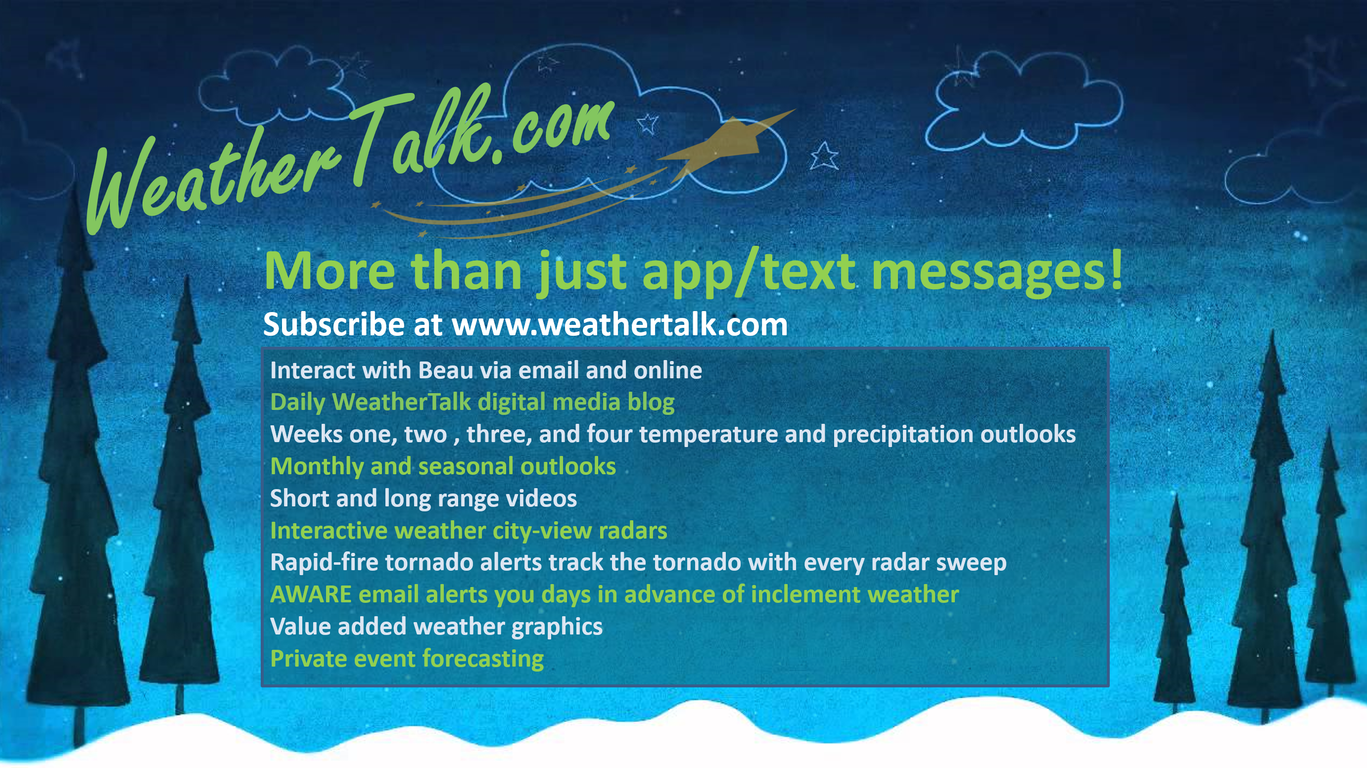
WeatherTalk monthly operating costs can top $2000.00. Your $5 subscription helps pay for those costs. I work for you.
The $5 will allow you to register up to seven phones!
For $5 a month you can receive the following. You may choose to receive these via your WeatherTalk app or regular text messaging.
Severe weather app/text alerts from my keyboard to your app/cell phone. These are hand typed messages from me to you. During tornado outbreaks, you will receive numerous app/text messages telling you exactly where the tornado is located.
- Daily forecast app/texts from my computer to your app/cell phone.
- Social media links sent directly to your app/cell phone. When I update the blog, videos, or Facebook you will receive the link.
- AWARE emails. These emails keep you well ahead of the storm. They give you several days of lead time before significant weather events.
- Direct access to Beau via text and email. Your very own personal meteorologist. I work for you!
- Missouri and Ohio Valley centered video updates
- Long-range weather videos
- Week one, two, three and four temperature and precipitation outlooks.
Monthly outlooks. - Your subscription also will help support several local charities.
Would you like to subscribe? Subscribe at www.beaudodsonweather.com
Typical progression on a severe weather day for subscribers.

I encourage subscribers to use the app vs regular text messaging. We have found text messaging to be delayed during severe weather. The app typically will receive the messages instantly. I recommend people have three to four methods of receiving their severe weather information.
Remember, my app and text alerts are hand typed and not computer generated. You are being given my personal attention during significant weather events.

WWW.WEATHERTALK.COM subscribers, here is my day to day schedule for your weather products.
These are bonus videos and maps for subscribers. I bring these to you from the BAMwx team. I pay them to help with videos.
The Ohio and Missouri Valley videos cover most of our area. They do not have a specific Tennessee Valley forecast but may add one in the future.
The long-range video is technical. Over time, you can learn a lot about meteorology from the long range video. Just keep in mind, it is a bit more technical.


Subscribe at www.weathertalk.com
![]()

Beau’s eight-day snow outlook.
Subscribe at www.weathertalk.com

![]()
January 14, 2019
Monday’s Forecast: Patchy morning fog. Mostly cloudy sky conditions. It will be cool. Temperatures will be a bit cooler where snow remains on the ground.
My confidence in the forecast verifying: High (90% confidence in the forecast)
Temperature range: MO Bootheel 35° to 40° SE MO 33° to 36° South IL 32° to 36° West KY 34° to 38° NW TN 36° to 38°
Wind direction and speed: North and northwest at 5 to 10 mph with gusts to 14 mph
Wind chill or heat index (feels like) temperature forecast: 25° to 30°
What is the chance/probability of precipitation? MO Bootheel 0% MO 0% IL 0% KY 0% TN 0%
Note: A 20% chance of rain does not mean it won’t rain. It simply means most areas will remain dry.
Coverage of precipitation: None
Is flash flooding anticipated? No
Will there be accumulating snow or ice? No
Will non-accumulating snow or ice occur? No
Are icy road conditions anticipated? No
Is severe weather expected? No
The NWS officially defines severe weather as 58 mph wind or great, 1″ hail or larger, and/or tornadoes
Is lightning anticipated? No
What impacts are anticipated from the weather? None
Should I cancel my outdoor plans? No
UV Index: 2 Low
Sunrise: 7:09 AM
** Note: Please, do me a favor. Log into your www.weathertalk.com account and make sure it does not say free. We have quite a few expired accounts. You would still be receiving app/text messages even if your account credit card/PayPal expired. I have to manually shut them off. I appreciate it. Thank you. **
Monday Night Forecast Details:
Forecast: Partly to mostly cloudy. Some clearing late. Chilly temperatures. Patchy fog.
My confidence in the forecast verifying: High (80% confidence in the forecast)
Temperature range: MO Bootheel 26° to 30° SE MO 23° to 26° South IL 22° to 26° West KY 24° to 26° NW TN 26° to 30°
Wind direction and speed: West and southwest at 4 to 8 mph
Wind chill or heat index (feels like) temperature forecast: 16° to 24°
What is the chance/probability of precipitation? MO Bootheel 0% MO 0% IL 0% KY 0% TN 0%
Note: A 20% chance of rain does not mean it won’t rain. It simply means most areas will remain dry.
Coverage of precipitation: None
Is flash flooding anticipated? No
Will there be accumulating snow or ice? No
Will non-accumulating snow or ice occur? No
Are icy road conditions anticipated? No
Is severe weather expected? No
The NWS officially defines severe weather as 58 mph wind or great, 1″ hail or larger, and/or tornadoes
Is lightning anticipated? No
What impacts are anticipated from the weather? Lower visibility where fog occurs.
Should I cancel my outdoor plans? No
Sunset: 4:59 PM
Moonrise: 11:56 AM
The phase of the moon: Waxing Gibbous
Moonset: 12:08 AM
January 15, 2019
Tuesday’s Forecast: Morning patchy fog possible. Partly sunny. Cool. Temperatures will be a bit cooler where snow remains on the ground.
My confidence in the forecast verifying: High (80% confidence in the forecast)
Temperature range: MO Bootheel 43° to 46° SE MO 43° to 45° South IL 40° to 45° West KY 42° to 46° NW TN 45° to 48°
Wind direction and speed: Southwest at 7 to 14 mph with gusts to 18 mph
Wind chill or heat index (feels like) temperature forecast: 40° to 45°
What is the chance/probability of precipitation? MO Bootheel 0% MO 0% IL 0% KY 0% TN 0%
Note: A 20% chance of rain does not mean it won’t rain. It simply means most areas will remain dry.
Coverage of precipitation: None
Is flash flooding anticipated? No
Will there be accumulating snow or ice? No
Will non-accumulating snow or ice occur? No
Are icy road conditions anticipated? No
Is severe weather expected? No
The NWS officially defines severe weather as 58 mph wind or great, 1″ hail or larger, and/or tornadoes
Is lightning anticipated? No
What impacts are anticipated from the weather? Fog could reduce visibility in some areas.
Should I cancel my outdoor plans? No
UV Index: 2 Low
Sunrise: 7:09 AM
Tuesday Night Forecast Details:
Forecast: Partly cloudy. Patchy fog possible.
My confidence in the forecast verifying: High (80% confidence in the forecast)
Temperature range: MO Bootheel 32° to 34° SE MO 30° to 34° South IL 28° to 34° West KY 32° to 34° NW TN 32° to 34°
Wind direction and speed: Southwest at 4 to 8 mph
Wind chill or heat index (feels like) temperature forecast: 25° to 30°
What is the chance/probability of precipitation? MO Bootheel 0% MO 0% IL 0% KY 0% TN 0%
Note: A 20% chance of rain does not mean it won’t rain. It simply means most areas will remain dry.
Coverage of precipitation: None
Is flash flooding anticipated? No
Will there be accumulating snow or ice? No
Will non-accumulating snow or ice occur? No
Are icy road conditions anticipated? No
Is severe weather expected? No
The NWS officially defines severe weather as 58 mph wind or great, 1″ hail or larger, and/or tornadoes
Is lightning anticipated? No
What impacts are anticipated from the weather? Fog could reduce visibility in some areas.
Should I cancel my outdoor plans? No
Sunset: 5:01 PM
Moonrise: 12:30 PM
The phase of the moon: Waxing Gibbous
Moonset: 1:08 AM
January 16, 2019
Wednesday’s Forecast: Partly to mostly sunny. Increasing PM clouds. Temperatures will be a bit cooler where snow remains on the ground.
My confidence in the forecast verifying: High (70% confidence in the forecast)
Temperature range: MO Bootheel 50° to 54° SE MO 45° to 50° South IL 40° to 50° West KY 50° to 52° NW TN 50° to 54°
Wind direction and speed: Southwest at 5 to 10 mph
Wind chill or heat index (feels like) temperature forecast: 45° to 50°
What is the chance/probability of precipitation? MO Bootheel 0% MO 0% IL 0% KY 0% TN 0%
Note: A 20% chance of rain does not mean it won’t rain. It simply means most areas will remain dry.
Coverage of precipitation: None
Is flash flooding anticipated? No
Will there be accumulating snow or ice? No
Will non-accumulating snow or ice occur? No
Are icy road conditions anticipated? No
Is severe weather expected? No
The NWS officially defines severe weather as 58 mph wind or great, 1″ hail or larger, and/or tornadoes
Is lightning anticipated? No
What impacts are anticipated from the weather? None
Should I cancel my outdoor plans? No
UV Index: 2 Low
Sunrise: 7:08 AM
Wednesday Night Forecast Details:
Forecast: Cloudy. A chance of rain showers.
My confidence in the forecast verifying: High (70% confidence in the forecast)
Temperature range: MO Bootheel 32° to 40° SE MO 38° to 42° South IL 32° to 40° West KY 38° to 40° NW TN 36° to 42°
Wind direction and speed: West at 7 to 14 mph with gusts to 30 mph
Wind chill or heat index (feels like) temperature forecast: 34° to 40°
What is the chance/probability of precipitation? MO Bootheel 30% MO 30% IL 20% KY 20% TN 20%
Note: A 20% chance of rain does not mean it won’t rain. It simply means most areas will remain dry.
Coverage of precipitation: Scattered late
Is flash flooding anticipated? No
Will there be accumulating snow or ice? No
Will non-accumulating snow or ice occur? No
Are icy road conditions anticipated? No
Is severe weather expected? No
The NWS officially defines severe weather as 58 mph wind or great, 1″ hail or larger, and/or tornadoes
Is lightning anticipated? No
What impacts are anticipated from the weather? Wet roadways.
Should I cancel my outdoor plans? No
Sunset: 5:02 PM
Moonrise: 1:06 PM
The phase of the moon: Waxing Gibbous
Moonset: 2:11 AM
![]()
January 17, 2019
Thursday’s Forecast: Increasing clouds with a chance of a shower. Mild.
My confidence in the forecast verifying: Medium (40% confidence in the forecast)
Temperature range: MO Bootheel 53° to 56° SE MO 48° to 55° South IL 46° to 52° West KY 52° to 56° NW TN 54° to 58°
Wind direction and speed: Southwest at 5 to 10 mph
Wind chill or heat index (feels like) temperature forecast: 45° to 50°
What is the chance/probability of precipitation? MO Bootheel 40% MO 40% IL 40% KY 40% TN 40%
Note: A 20% chance of rain does not mean it won’t rain. It simply means most areas will remain dry.
Coverage of precipitation: Scattered to perhaps numerous
Is flash flooding anticipated? No
Will there be accumulating snow or ice? No
Will non-accumulating snow or ice occur? No
Are icy road conditions anticipated? No
Is severe weather expected? No
The NWS officially defines severe weather as 58 mph wind or great, 1″ hail or larger, and/or tornadoes
Is lightning anticipated? No
What impacts are anticipated from the weather? Wet roadways.
Should I cancel my outdoor plans? Monitor updates.
UV Index: 1 Low
Sunrise: 7:08 AM
Thursday Night Forecast Details:
Forecast: Cloudy. A chance of a few remaining rain showers.
My confidence in the forecast verifying: Medium (40% confidence in the forecast)
Temperature range: MO Bootheel 38° to 42° SE MO 32° to 40° South IL 30° to 38° West KY 38° to 42° NW TN 40° to 42°
Wind direction and speed: West at 6 to 12 mph
Wind chill or heat index (feels like) temperature forecast: 30° to 40°
What is the chance/probability of precipitation? MO Bootheel 40% MO 40% IL 40% KY 40% TN 40%
Note: A 20% chance of rain does not mean it won’t rain. It simply means most areas will remain dry.
Coverage of precipitation: Scattered
Is flash flooding anticipated? No
Will there be accumulating snow or ice? No
Will non-accumulating snow or ice occur? No
Are icy road conditions anticipated? No
Is severe weather expected? No
The NWS officially defines severe weather as 58 mph wind or great, 1″ hail or larger, and/or tornadoes
Is lightning anticipated? No
What impacts are anticipated from the weather? Wet roadways.
Should I cancel my outdoor plans? Monitor updates.
Sunset: 5:02 PM
Moonrise: 1:50 PM
The phase of the moon: Waxing Gibbous
Moonset: 3:17 AM
January 18, 2019
Friday’s Forecast: Cloudy. A shower possible.
My confidence in the forecast verifying: Medium (40% confidence in the forecast)
Temperature range: MO Bootheel 50° to 52° SE MO 44° to 54° South IL 42° to 52° West KY 48° to 54° NW TN 53° to 56°
Wind direction and speed: Variable at 5 to 10 mph with gusts to 14
Wind chill or heat index (feels like) temperature forecast: 45° to 50°
What is the chance/probability of precipitation? MO Bootheel 20% MO 20% IL 20% KY 20% TN 20%
Note: A 20% chance of rain does not mean it won’t rain. It simply means most areas will remain dry.
Coverage of precipitation: Monitor
Is flash flooding anticipated? No
Will there be accumulating snow or ice? No
Will non-accumulating snow or ice occur? No
Are icy road conditions anticipated? No
Is severe weather expected? No
The NWS officially defines severe weather as 58 mph wind or great, 1″ hail or larger, and/or tornadoes
Is lightning anticipated? Not at this time
What impacts are anticipated from the weather? Perhaps some wet roadways
Should I cancel my outdoor plans? No, but monitor updates
UV Index: 1 to 2 Low
Sunrise: 7:08 AM
** Changeable weather forecasts **
Monitor updates concerning the Friday night, Saturday, and Saturday night forecast. Confidence in the details are low. A potential winter storm will impact portions of the Missouri and Ohio Valleys. Whether it impacts my forecast counties remains a question.
Friday Night Forecast Details:
Forecast: Cloudy. A chance of rain showers. Rain showers may turn to snow showers. Colder.
My confidence in the forecast verifying: Low (30% confidence in the forecast)
Temperature range: MO Bootheel 34° to 38° SE MO 30° to 35° South IL 30° to 36° West KY 32° to 36° NW TN 35° to 40°
Wind direction and speed: Variable wind direction at 7 to 14 mph with gusts to 20 mph
Wind chill or heat index (feels like) temperature forecast: 20° to 32°
What is the chance/probability of precipitation? MO Bootheel 50% MO 50% IL 50% KY 50% TN 50%
Note: A 20% chance of rain does not mean it won’t rain. It simply means most areas will remain dry.
Coverage of precipitation: Scattered to perhaps numerous
Is flash flooding anticipated? No
Will there be accumulating snow or ice? Monitor
Will non-accumulating snow or ice occur? Possible
Are icy road conditions anticipated? Monitor
Is severe weather expected? No
The NWS officially defines severe weather as 58 mph wind or great, 1″ hail or larger, and/or tornadoes
Is lightning anticipated? No
What impacts are anticipated from the weather? Wet roadways. Monitor the risk of wintry precipitation.
Should I cancel my outdoor plans? No, but monitor updates.
Sunset: 5:04 PM
Moonrise: 2:38 PM
The phase of the moon: Waxing Gibbous
Moonset: 4:23 AM
January 19, 2019
Saturday’s Forecast: Mostly cloudy. A chance of rain, sleet, and snow.
My confidence in the forecast verifying: Low (30% confidence in the forecast)
Temperature range: MO Bootheel 34° to 36° SE MO 30° to 35° South IL 30° to 35° West KY 35° to 40° NW TN 36° to 40°
Wind direction and speed: North at 10 to 20 mph
Wind chill or heat index (feels like) temperature forecast: 20° to 30°
What is the chance/probability of precipitation? MO Bootheel 50% MO 50% IL 50% KY 50% TN 50%
Note: A 20% chance of rain does not mean it won’t rain. It simply means most areas will remain dry.
Coverage of precipitation: Numerous
Is flash flooding anticipated? No
Will there be accumulating snow or ice? Monitor
Will non-accumulating snow or ice occur? Possible
Are icy road conditions anticipated? Monitor the chance of icy road conditions. A bit early for certainties.
Is severe weather expected? No
The NWS officially defines severe weather as 58 mph wind or great, 1″ hail or larger, and/or tornadoes
Is lightning anticipated? No
What impacts are anticipated from the weather? Wet roadways. Monitor the chance of icy road conditions. A bit early for certainties.
Should I cancel my outdoor plans? Monitor updates.
UV Index: 2 Low
Sunrise: 7:07 AM
Saturday Night Forecast Details:
Forecast: Mostly cloudy. Sharply colder. A chance of snow and sleet.
My confidence in the forecast verifying: Medium (40% confidence in the forecast)
Temperature range: MO Bootheel 20° to 24° SE MO 18° to 24° South IL 18° to 24° West KY 24° to 28° NW TN 25° to 30°
Wind direction and speed: North and northwest at 6 to 12 mph with gusts to 20 mph
Wind chill or heat index (feels like) temperature forecast: 18° to 24°
What is the chance/probability of precipitation? MO Bootheel 40% MO 40% IL 40% KY 40% TN 40%
Note: A 20% chance of rain does not mean it won’t rain. It simply means most areas will remain dry.
Coverage of precipitation: Scattered
Is flash flooding anticipated? No
Will there be accumulating snow or ice? Monitor
Will non-accumulating snow or ice occur? Yes
Are icy road conditions anticipated? Monitor the chance of icy road conditions. A bit early for certainties.
Is severe weather expected? No
The NWS officially defines severe weather as 58 mph wind or great, 1″ hail or larger, and/or tornadoes
Is lightning anticipated? No
What impacts are anticipated from the weather? Monitor the chance of icy road conditions. A bit early for certainties.
Should I cancel my outdoor plans? Monitor updates
Sunset: 5:05 PM
Moonrise: 3:37 PM
The phase of the moon: Waxing Gibbous
Moonset: 5:30 AM
Learn more about the UV index readings. Click here.
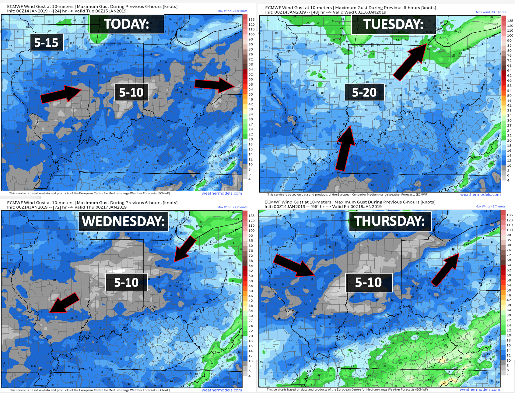
The wind speed and direction forecast.
Monday, January 14th: Wintry precipitation is not anticipated
Tuesday, January 15th: Wintry precipitation is not anticipated
Wednesday, January 16th: Wintry precipitation is not anticipated
Thursday, January 17th: Wintry precipitation is not anticipated
Friday, January 18th: Wintry precipitation is not anticipated during the day.
Friday night into Saturday night. January 18th and 19th: A wintry mix is possible. The exact track of a potential winter storm is still an unknown. Monitor updates.
Beau’s eight-day winter weather outlook!
Southern Illinois.
Subscribe at www.weathertalk.com
Southeast Missouri (excluding the Missouri Bootheel)
Subscribe at www.weathertalk.com
The Missouri Bootheel (New Madrid, Dunklin, and Pemiscot counties.
Subscribe at www.weathertalk.com
Western Kentucky
Subscribe at www.weathertalk.com
Northwest Tennessee
Subscribe at www.weathertalk.com
NOTICE:
I encourage subscribers to use the app vs regular text messaging. They will be the same messages. We have found text messaging to be delayed during severe weather. The app typically will receive the messages instantly. I recommend people have three to four methods of receiving their severe weather information.
Remember, my app and text alerts are hand typed and not computer generated. You are being given personal attention during significant weather events.

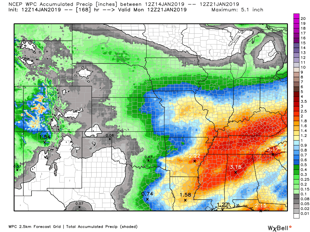
Here is the latest graphic from the WPC/NOAA.
This map shows you liquid and does not assume precipitation type. In other words, melted precipitation totals.
Subscribers, do you need a forecast for an outdoor event?

Did you know that you can find me on Twitter?


Click here for your interactive local city-view radars & regional radars.
During winter weather be sure and click the winterize button above each city-view radar. This will show you the precipitation type.

The National Weather Service defines a severe thunderstorm as one that produces quarter size hail or larger, 58 mph winds or greater, and/or a tornado.
Today through Friday: Severe weather is not anticipated.
Interactive live weather radar page. Choose the city nearest your location. If one of the cities does not work then try a nearby one. Click here.
National map of weather watches and warnings. Click here.
Storm Prediction Center. Click here.
Weather Prediction Center. Click here.

Live lightning data: Click here.

Interactive GOES R satellite. Track clouds. Click here.

Here are the latest local river stage forecast numbers Click Here.
Here are the latest lake stage forecast numbers for Kentucky Lake and Lake Barkley Click Here.

- Calm weather today into Wednesday night
- Another rain event possible Thursday into Friday
- A winter pattern is developing for late week into the following weeks
- Sharply colder weather in the charts.
Quick summary
Calm weather through Wednesday.
The main weather concern over the coming seven days will be rain chances Thursday and Friday. I am tracking a winter storm for the weekend, as well. Low confidence in the details. Keep checking back for updated information.
The next big weather story is going to be sharply colder air forecast to push into the region after this week. Some of the guidance is painting bitterly cold air. I am not a huge fan of long-range models. There are multiple signals for cold weather. That does add some confidence that winter temperatures are on the way.
Forecast details.
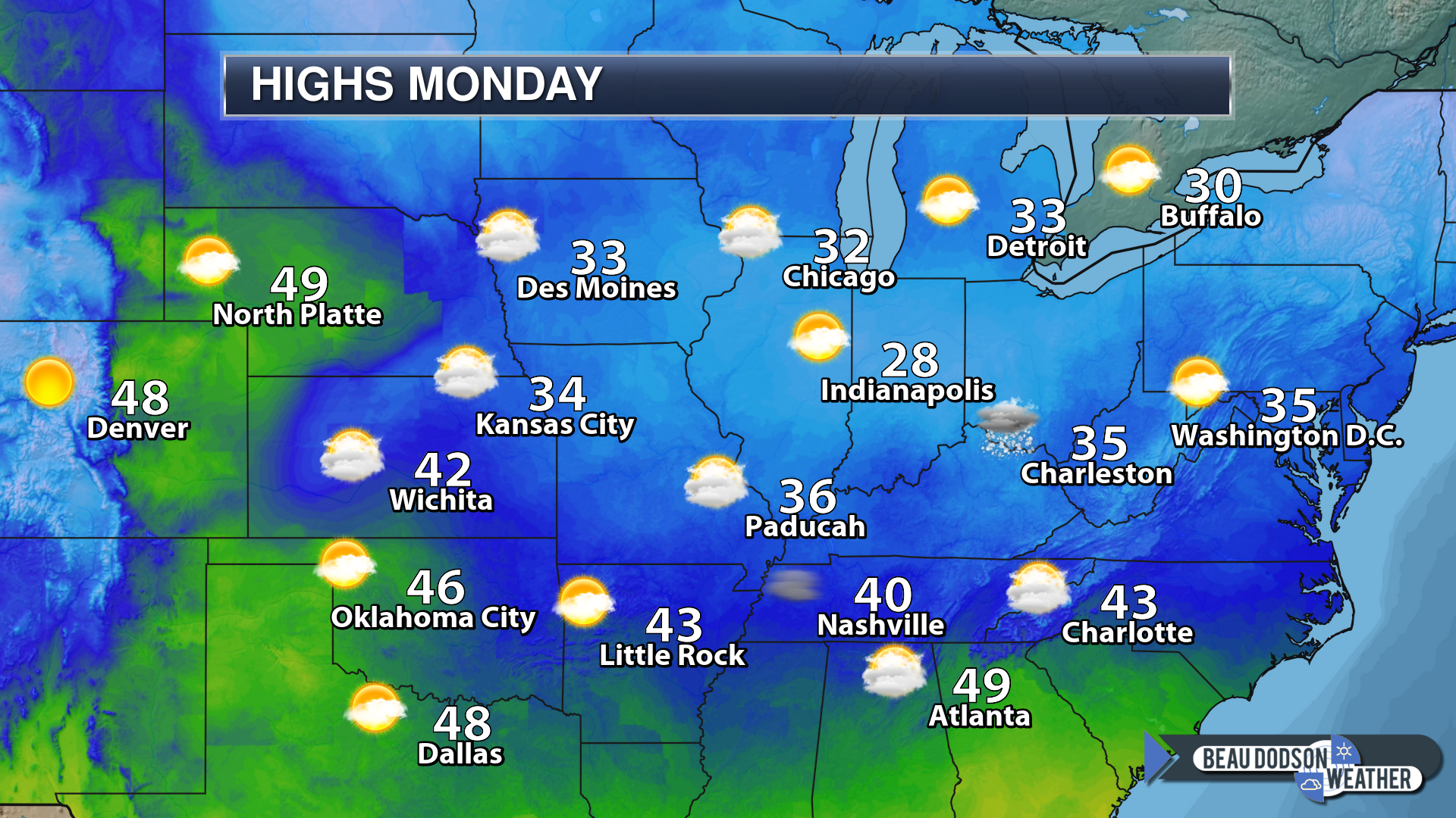
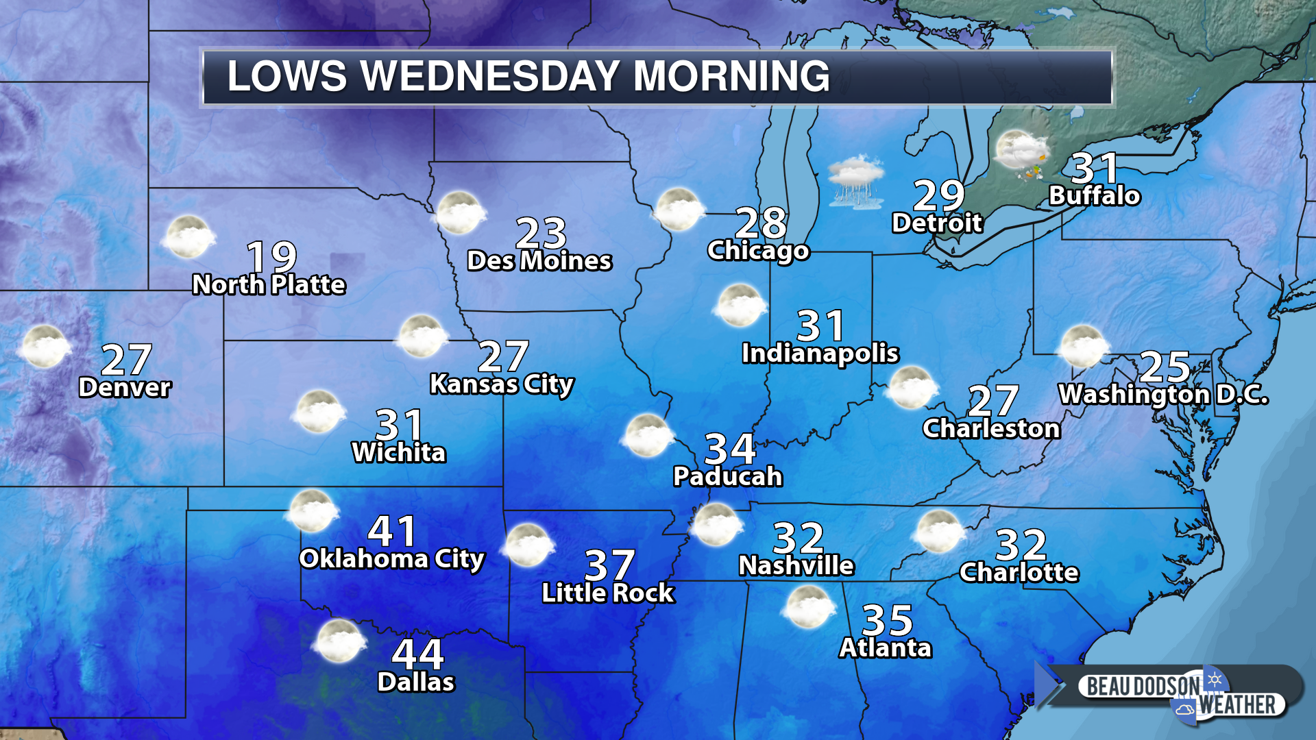
Today’s high-temperature forecast
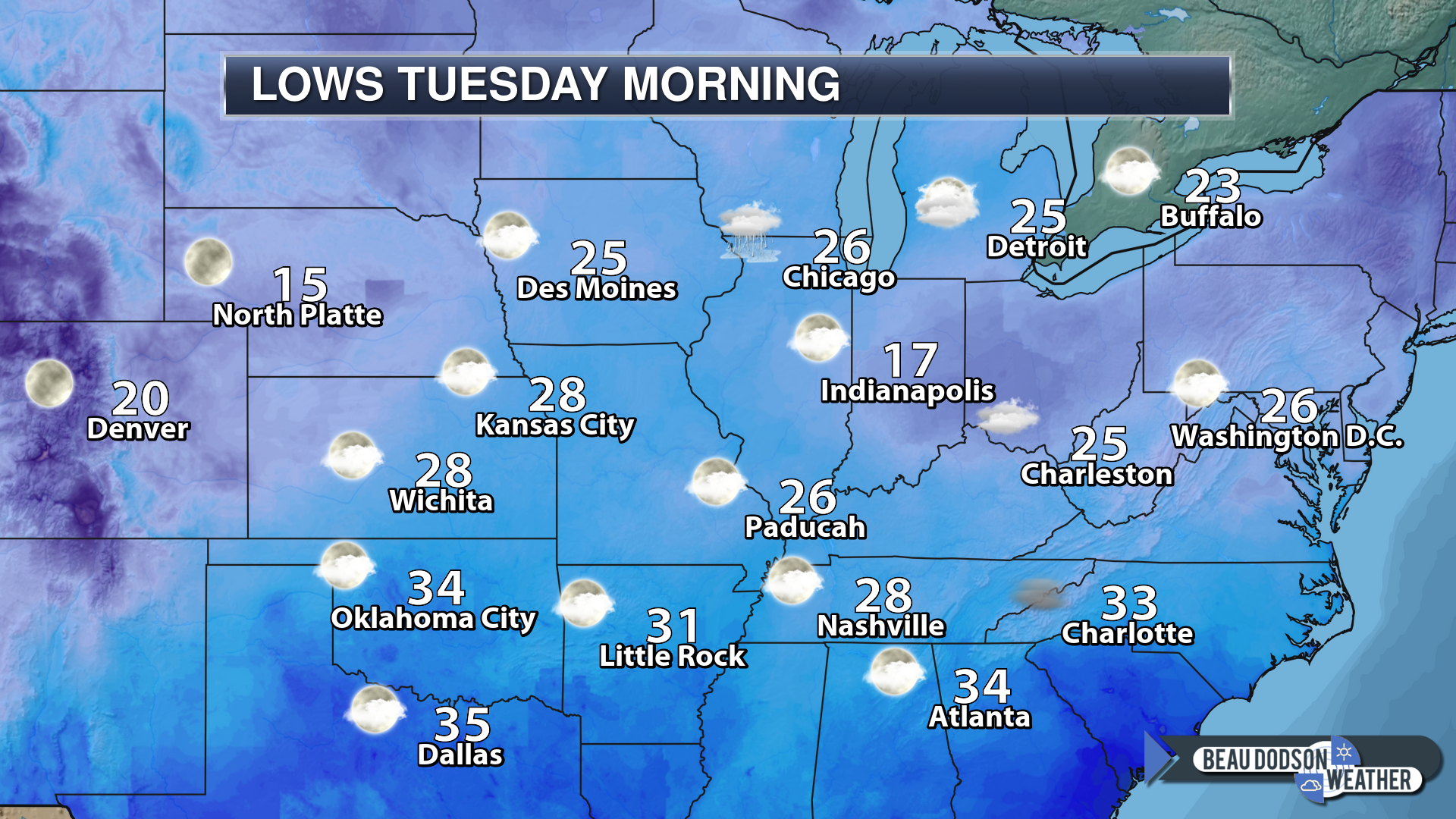
Tonight’s low-temperature forecast
Tomorrow’s high-temperature forecast
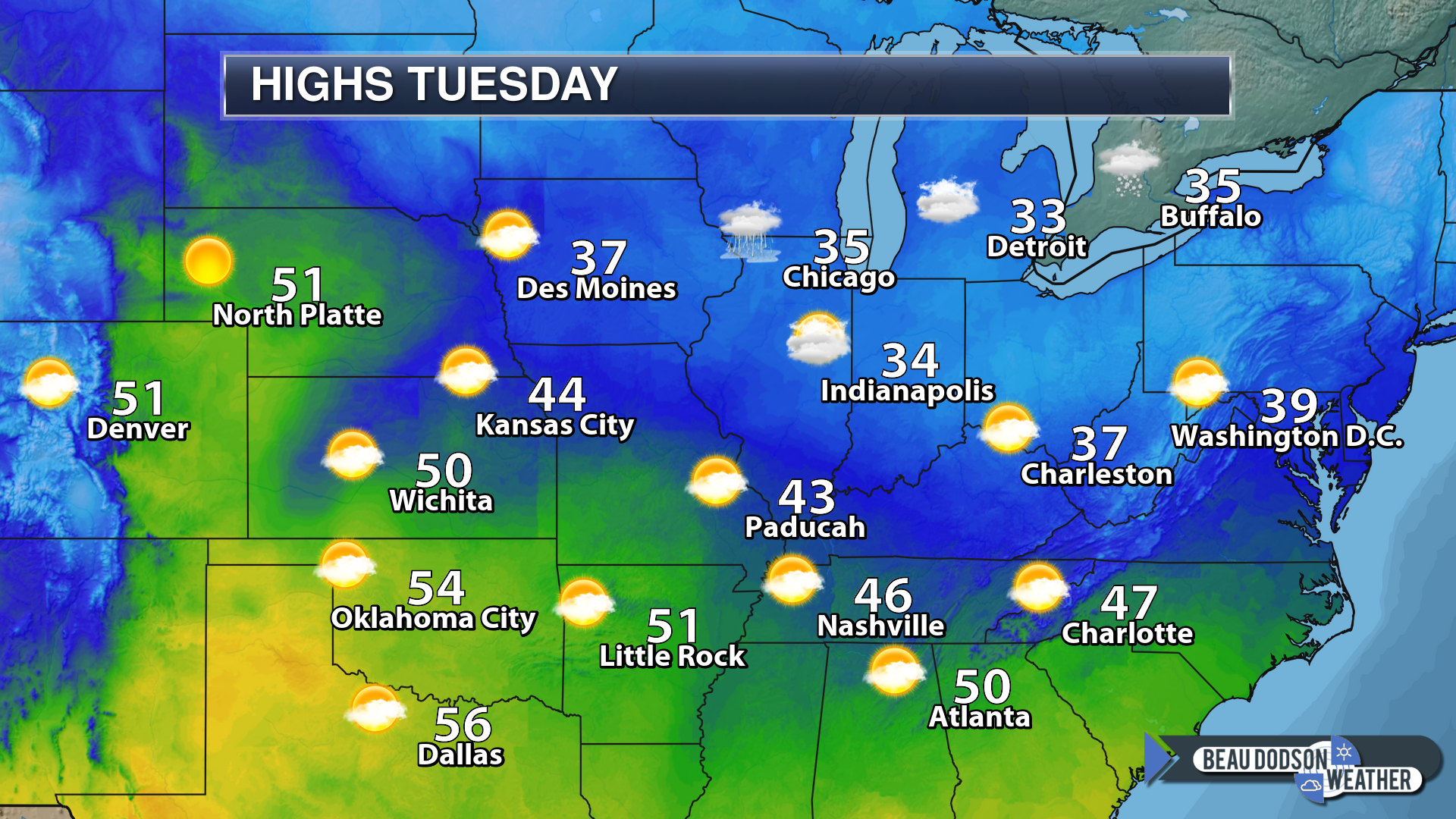
Tomorrow night’s low-temperature forecast
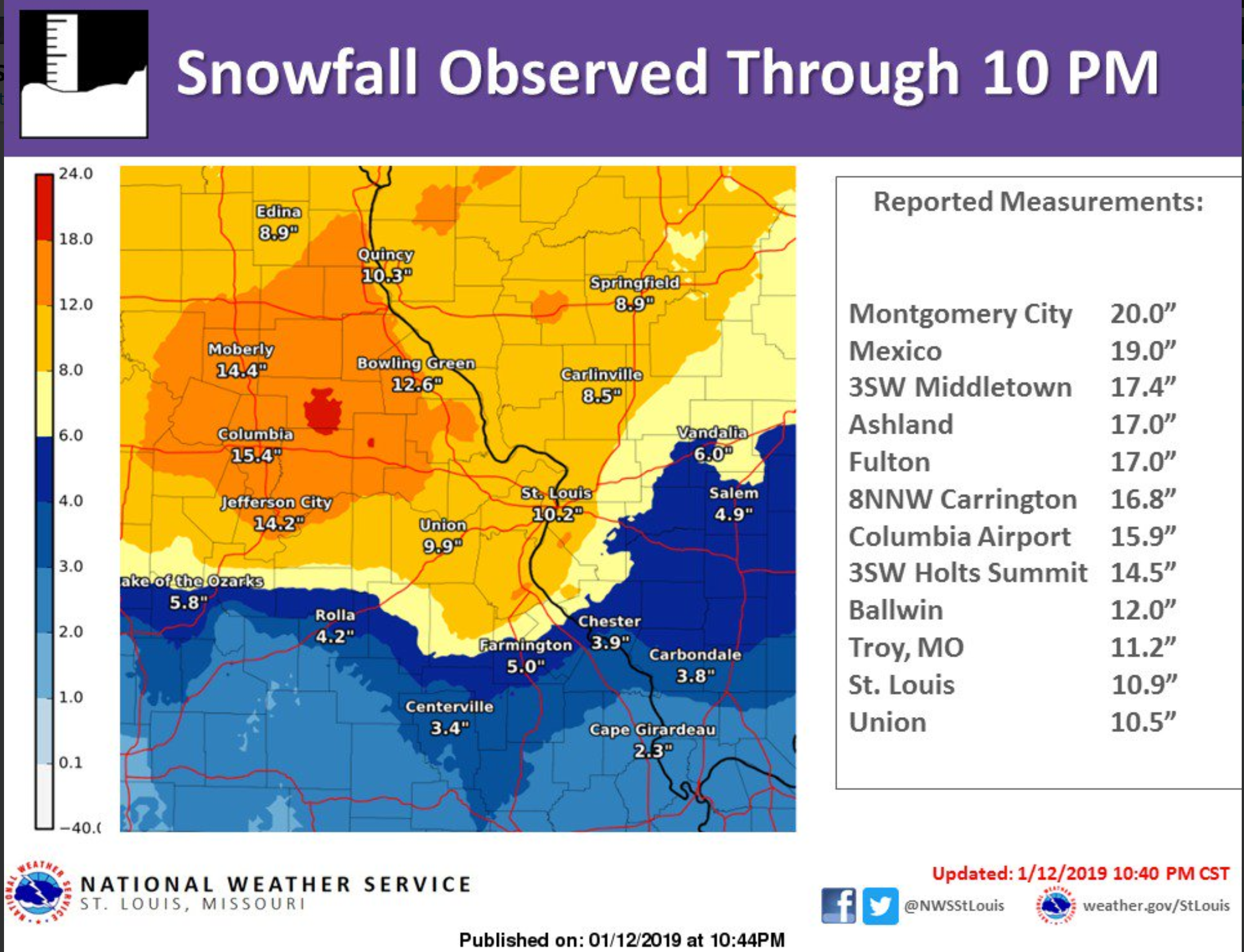
We had a bit of a weather ride over the weekend. Widespread rain, freezing rain, sleet, and snow impacted the region.
Some of you received north of six inches of snow! Other locations received no measurable snow. That was the forecast.
Here are some of the snow totals since Friday.
Click to enlarge
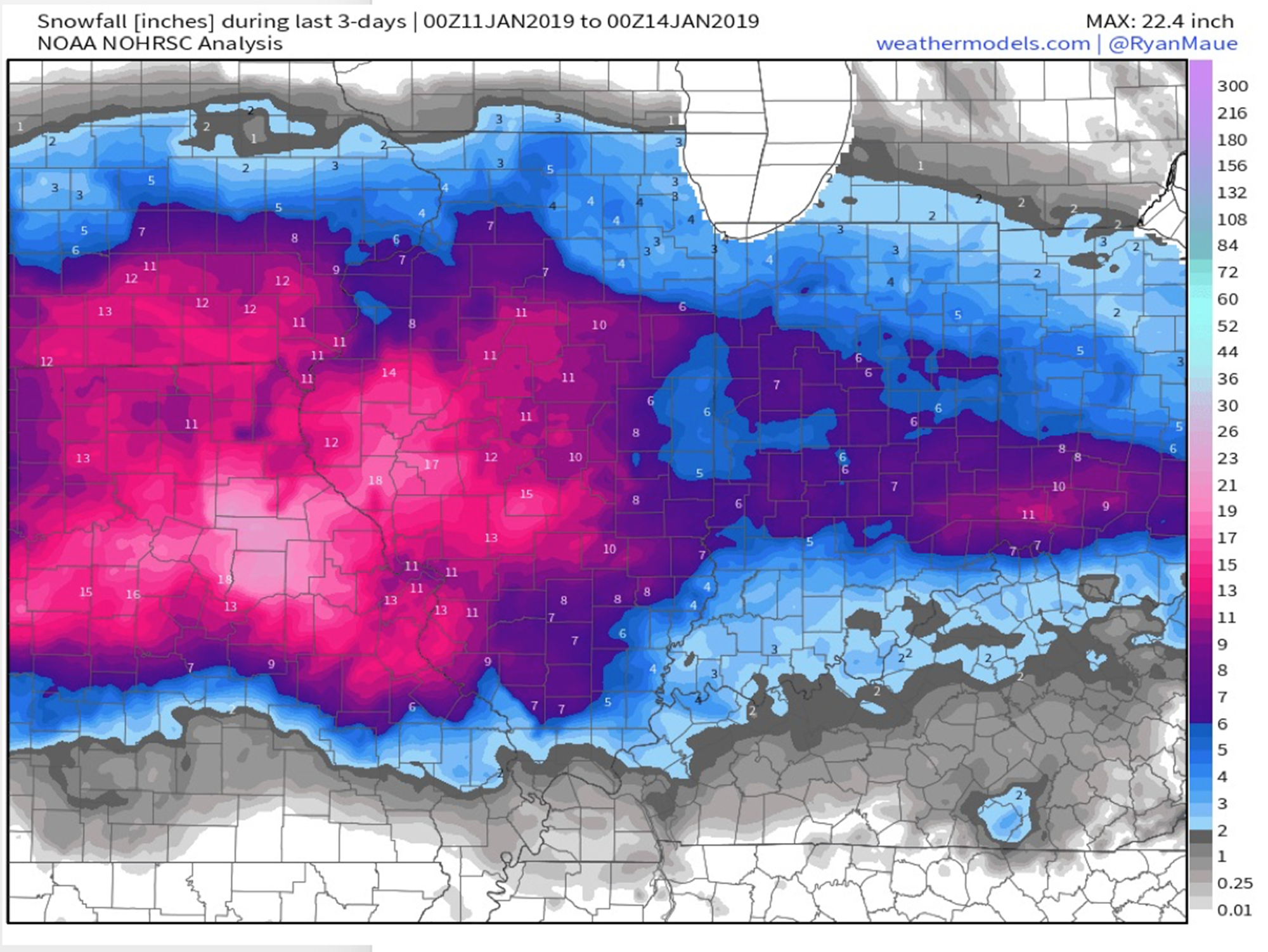
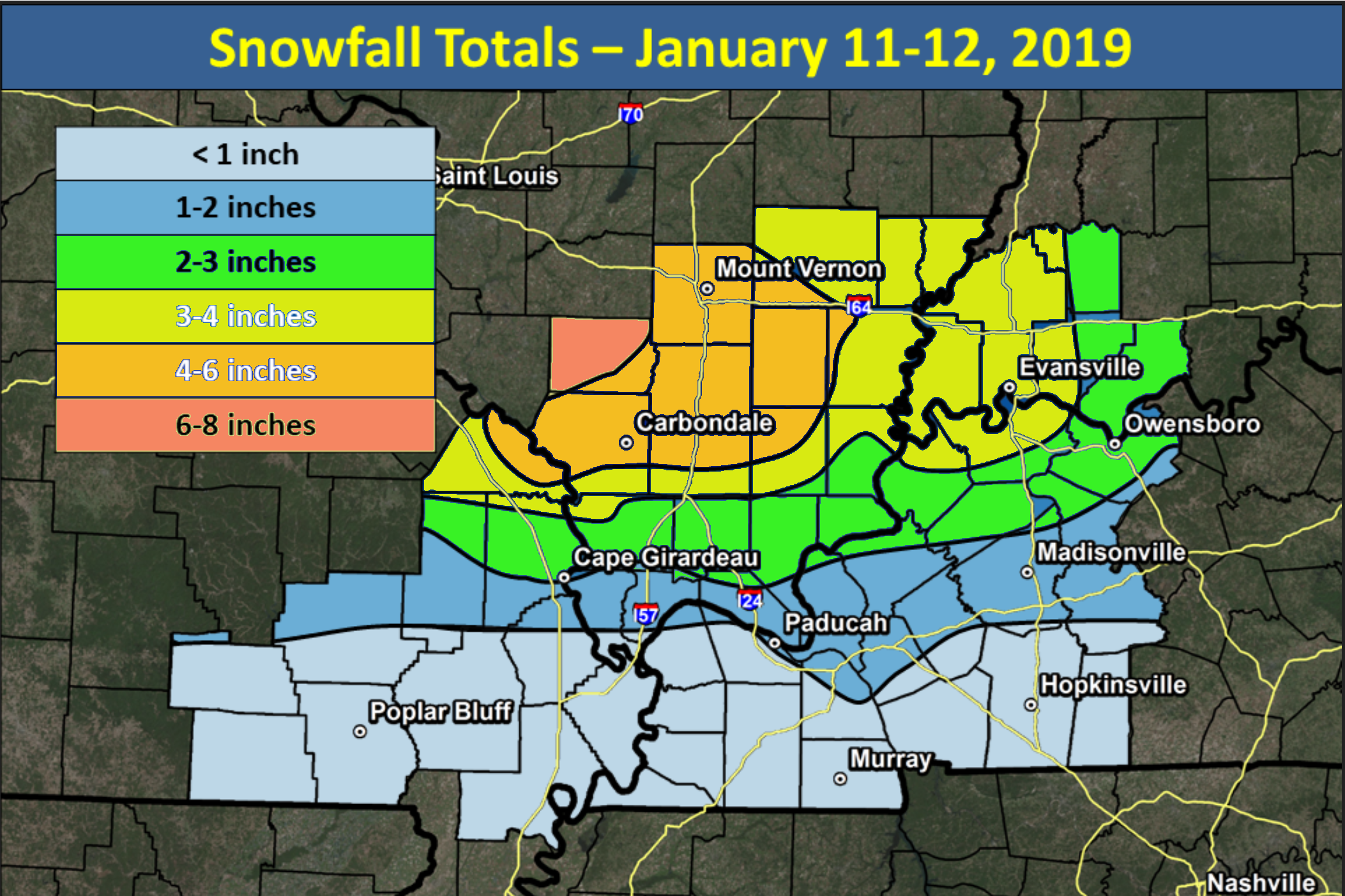
Check out these amazing snow totals across portions of Missouri and Illinois.
This was an impressive winter storm.
That particular winter storm is history.
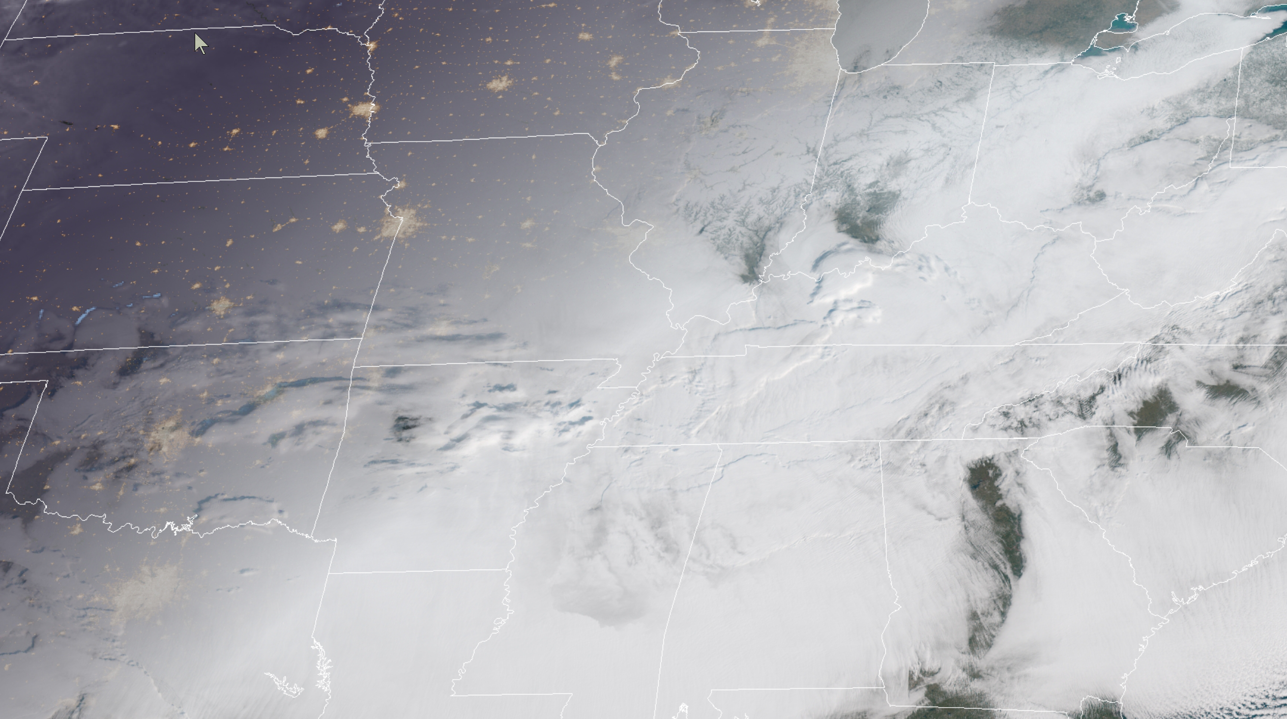
For the most part, clouds will linger today. Morning satellite did show a few small breaks in the cloud cover. Mainly over portions of southern Illinois.
Here was the morning satellite view (9 AM). Just a small area of broken clouds in southeast Illinois.
Interactive GOES R satellite. Track clouds. Click here.
We will have a better chance of partly sunny sky conditions by Tuesday and Wednesday. The sun will be a welcome sight after the weekend clouds.
The good news is that I am not anticipating any measurable precipitation today through Wednesday.
The rest of the week into the weekend.
I am already tracking additional precipitation events.
A significant winter storm may impact portions of the central and eastern United States Friday into the weekend.
Weather discussion:
I am tracking several precipitation events that will impact our region over the coming seven days.
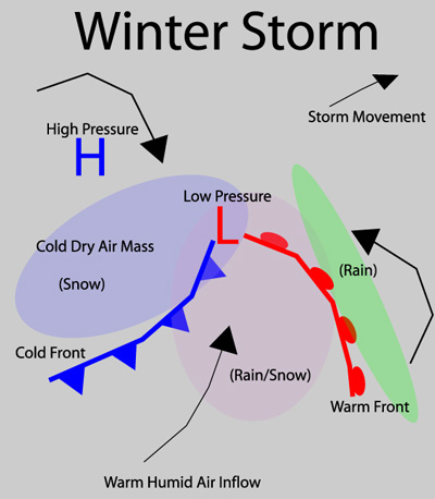
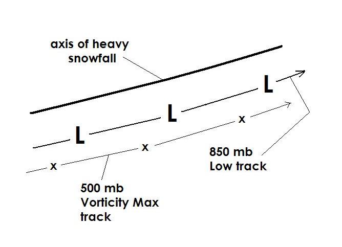
If you want heavy snow then you want to be north of the surface low and upper-level lows. How far north depends on the air-mass already in place. During some events, you have to be well north of the low.
Here is a diagram of that.
Most of you know what a low-pressure center looks like on a weather map. It is the red L. That is where the barometric pressure is the lowest.
There are also upper-level lows that are higher up in the atmosphere. One of those is the 850 MB low which is about 5000′ aloft.
If you want snow then you usually have to be on the northwest, north, and northeast of the center if low pressure.
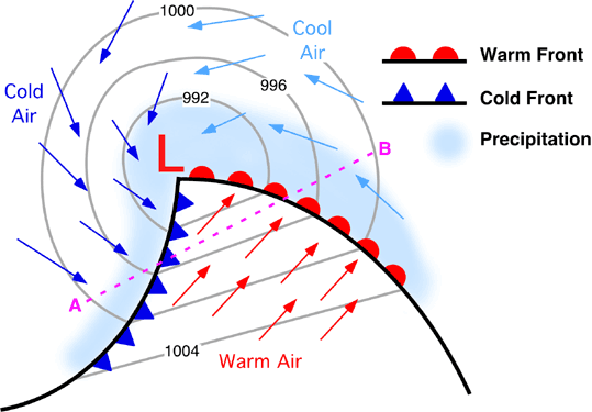
Here are some diagrams to illustrate.
The red L is the center of low pressure. Colder air is centered to the north and west of the low. Warmer air surges northward ahead of the cold front.
Remember, low pressure rotates counter-clockwise.
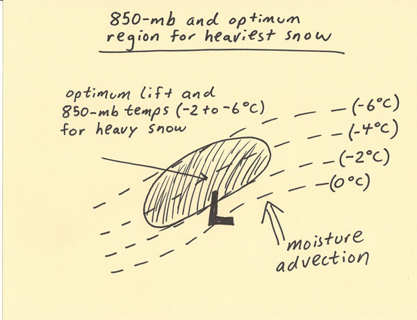
Here is an example of the 850 mb low. The heaviest snow normally occurs to the northwest of the 850 mb low. Again, the 850 mb low is about 5000′ aloft.
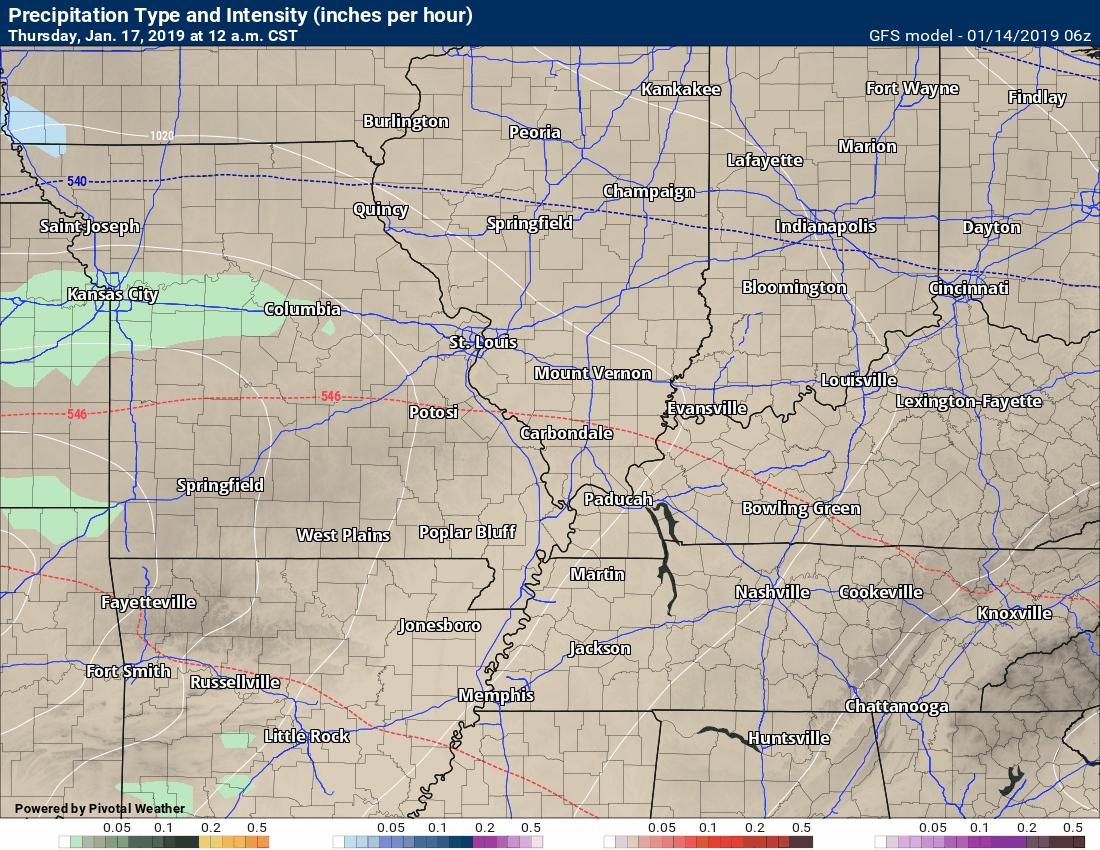
The next weather event to impact our region will arrive on Wednesday night and Thursday.
This system should be more wet than white, locally. It does not appear that it will be cold enough for measurable wintry precipitation.
I will keep a close eye on northern counties in case temperatures dip below freezing Wednesday night. For now, this appears to be a rain event.
Rain totals should be on the light side. I am forecasting less than 0.30″.
You can see that system here on the GFS model guidance. One model of many.
Green is rain. Blue is snow. Pink is a wintry mix. You can see that it paints all green locally. That is the going forecast.
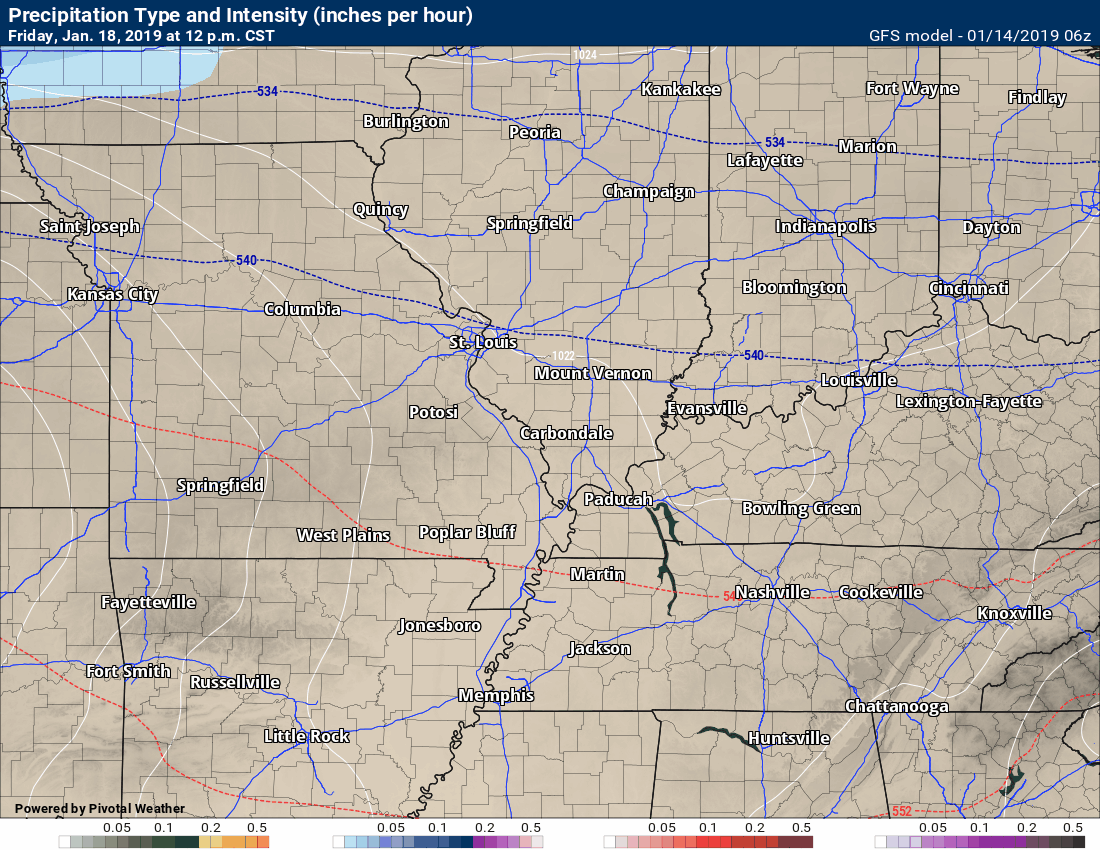
The next big weather story will be a system that quickly follows system one. It is forecast to arrive Friday into Saturday.
This has the potential to be a significant rain maker and winter storm across portions of the United States. Where, is the question.
The track of the system is still in play. The system in question is still out over the central Pacific Ocean. Other pieces of this event are north of Alaska. Needless to say, that is a long way away and models don’t handle the finer details that far away.
If the system tracks far enough south then we will have rain turning to freezing rain, sleet, and snow. If the system tracks further north then we will have mostly a rain event with some wintry mix at the end.
It is too early to know the outcome.
As we saw with our last storm system, portions of the region could be all rain and others could pick up heavy wintry precipitation. Often times, the details aren’t known until 24 to 48 hours in advance.
I will be monitoring the trends in the guidance, as always.
What is clear is that precipitation chances will ramp up later this week.
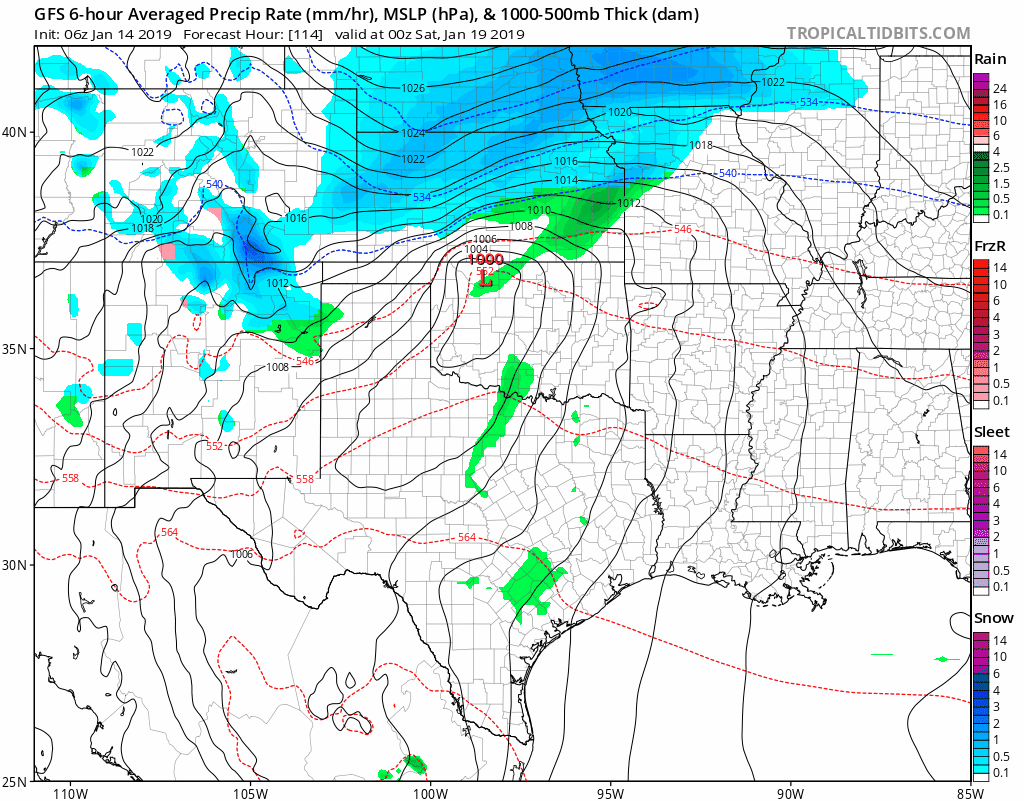
Here is what the GFS model guidance is showing for the weekend event. Again, take this with a grain of salt. A lot of variables will come into play before a final forecast is known.
Time-stamp upper left.
Green is rain. Yellow is moderate rain. Blue is snow. The darker blue is heavy snow. The pink, purple, and red colors would be a wintry mix of freezing rain, sleet, and snow.
Here is another model.
Green is rain. Yellow and orange colors are locally moderate to heavy rain. Blue is snow.
![]()
Here is another animation of the GFS model guidance. Again, we don’t get too caught in specifics this far out. Green is rain. Yellow and orange colors are locally moderate to heavy rain. Blue is snow.
The EC model guidance shows the area of low pressure in or near our region.
I will be monitoring the charts concerning the track of the low.
Click to enlarge. The little red L’s are where the 50 ensemble members track the area of low pressure.
Dozens of additional graphics and animations have been posted.
Subscribe at www.weathertalk.com
Long Range Temperature Anomaly Forecast
Let’s look at the temperature anomaly forecast map from the long-range GFS model guidance.
This graphic shows you whether temperatures are forecast to average above or below normal.
Red shades indicate above normal temperatures. Dark red to pink indicates much above normal temperatures.
Blue shades represent below normal temperatures. Purple to pink represents much below normal temperatures.
The time-stamp is located in the upper left portion of the map animation.
Click the image to enlarge it.
Here is the latest January and February outlook from the long-range team.
Click the graphic to enlarge it.
Subscribe at www.weathertalk.com
![]()
![]()

I bring these to you from the BAMwx team. They are excellent long-range forecasters.
Remember, long-range outlooks are a bit of skill, understanding weather patterns, and luck combined. It is not an exact science.

This product is for subscribers.
Subscribe at www.weathertalk.com
Subscriber graphics can be viewed on this page CLICK HERE

This product is for subscribers.

This product is for subscribers.
Subscribe at www.weathertalk.com
Subscriber graphics can be viewed on this page CLICK HERE
![]()
.
Winter Outlook!
These products are for subscribers.
December temperature and precipitation outlook
January temperature outlook
February temperature outlook
Winter snow outlook
.These products are for subscribers.
![]()

A new weather podcast is now available! Weather Geeks (which you might remember is on The Weather Channel each Sunday)
To learn more visit their website. Click here.
![]()

WeatherBrains Episode 676
Tonight’s show is the Brainchild of Mark Ingalls from Boardman, Oregon.
Tonight’s First Guest WeatherBrain has a special place in the pantheon of the show. He does the intro for Tony Rice’s weekly segment. To borrow a line that Kevin Selle used when he introduced Leo Laporte several years ago: “he has a voice like a basket of warm kittens.” He is the Chief Meteorologist for KIRO-TV in Seattle. Morgan Palmer, thanks for joining us!
Tonight’s next Guest WeatherBrain is a teaching Adjunct Professor at The University of British Columbia. He is an expert on Pacific Northwest windstorms. Dr. Wolf Read, welcome to WeatherBrains.
Tonight’s Final Guest WeatherBrain is a Professor of Atmospheric Sciences at the University of Washington. He is an expert on the weather in the pacific northwest. He also wrote a book, “The Weather of the Pacific Northwest”. Cliff Mass, welcome!
Joining us as Guest Panelist is a meteorologist for Portland General Electric. He forecasts for the utility and energy traders. Charlie Phillips, welcome to WeatherBrains!
Other discussions in this weekly podcast include topics like:
- Increasing wildfire issues in the western US
- The difficulty of winter weather forecasting in Washington State
- The Astronomy Report from Tony Rice
- and more!
Link to their website https://weatherbrains.com/
Previous episodes can be viewed by clicking here.
Find me on Facebook!

Find me on Twitter!

Did you know that a portion of your monthly subscription helps support local charity projects?
You can learn more about those projects by visiting the Shadow Angel Foundation website and the Beau Dodson News website.
