January 12, 2018
The daily outlook can be found at the bottom of this post.
Forecast
Interactive Weather Radar Page. Choose the city nearest your location: Click this link
There will be the free blog site located here Weather Talk Free Blog
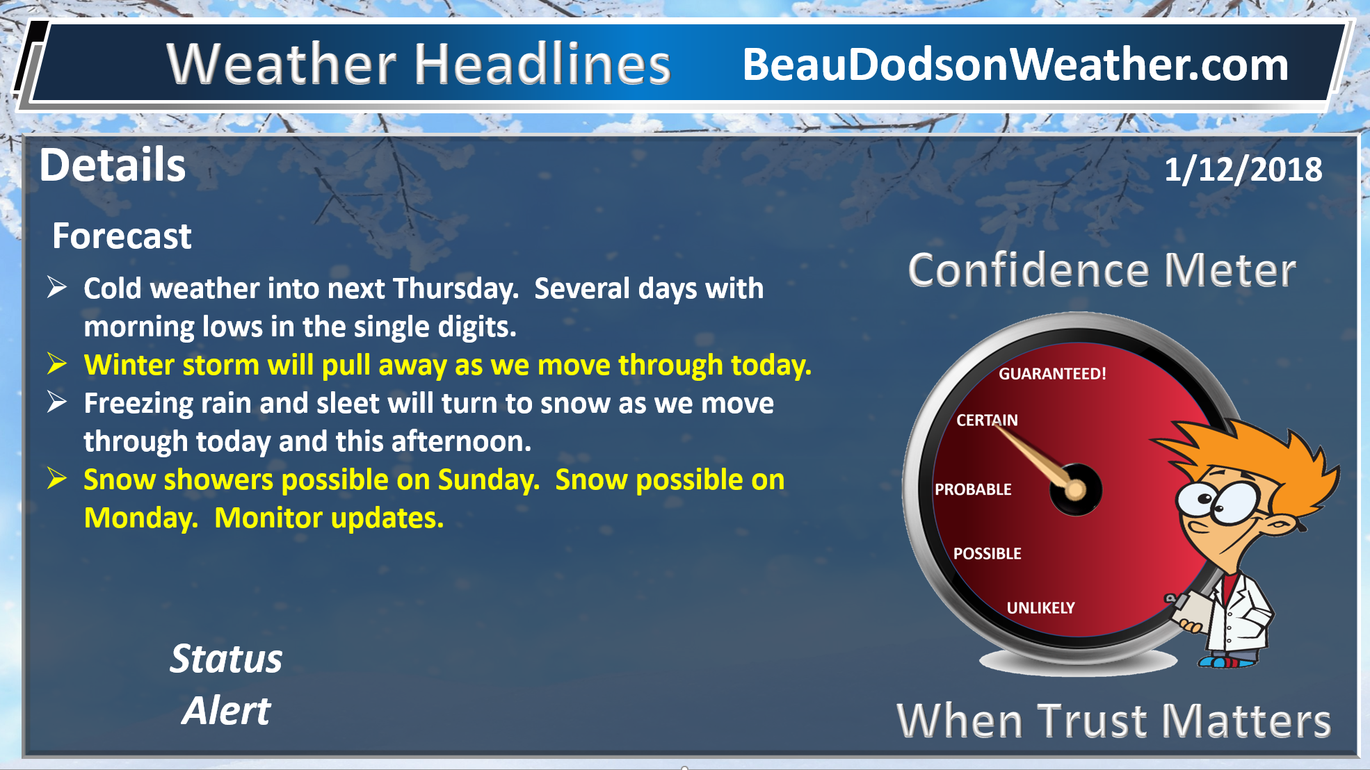
Today into early next week.
Cold with icy roads likely.
Widespread freezing rain and sleet spread across the region over the last 12 to 18 hours.
Sleet and freezing rain has coated everything with ice. Use care today.
Freezing rain, sleet, and snow will transition to all snow this morning into this afternoon. Precipitation will end over southeast Missouri and southwest Illinois first. It will then end from SW to NE later today.
The greatest chance of snow accumulation will be across southeast Illinois, western Kentucky, and western Tennessee.
Snow accumulations will range from a dusting to perhaps as much as four inches. The highest totals are more likely to be over western Kentucky. The further east you travel the better chance for higher totals.
There are some questions about snow totals for west Kentucky. Some guidance shows four to six inches. Low confidence on snow totals. I did mention a wild card potential of higher totals.
Southeast Missouri and southwest Illinois will see the least amount of snow.
Road conditions will remain hazardous today into the weekend.
If we can pop some sun on Saturday or Sunday then that will help with road conditions.
It will be cold over the coming days.
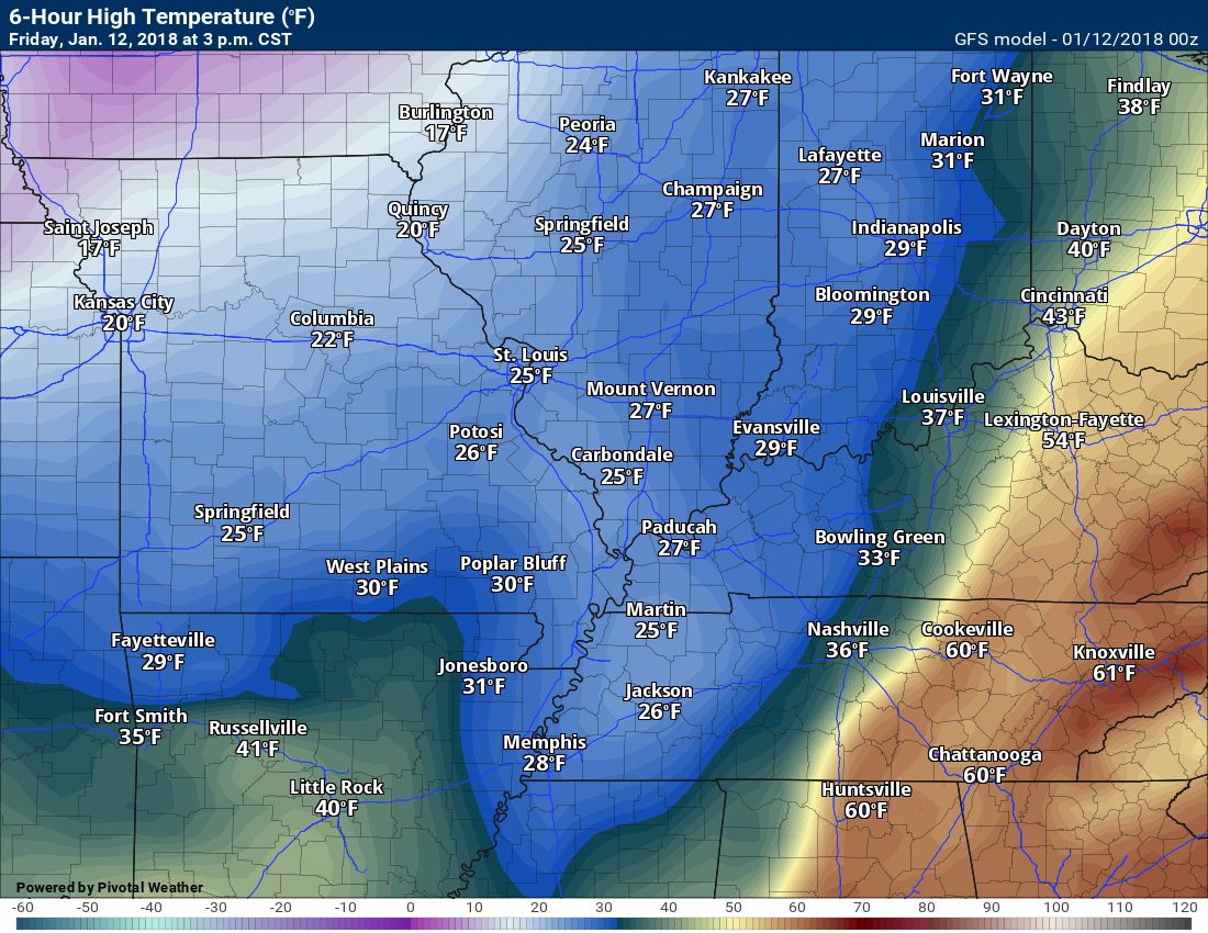
Today’s high temperature map
.
.
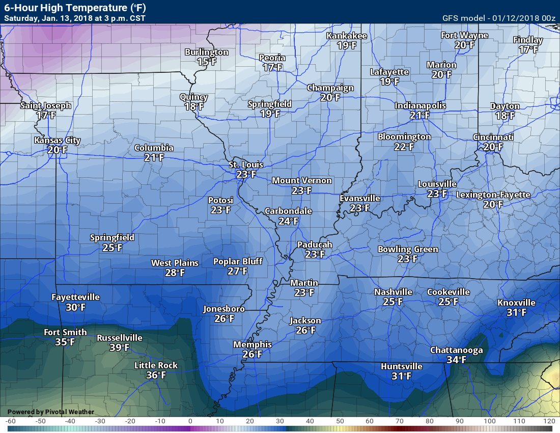
Saturday 3 PM temperature map
.
.
Sunday 3 PM temperature map
.

.
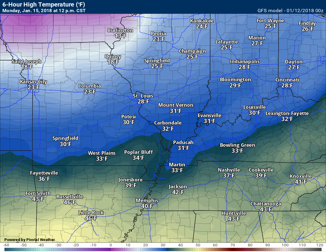
Monday 3 PM temperature map
.
.
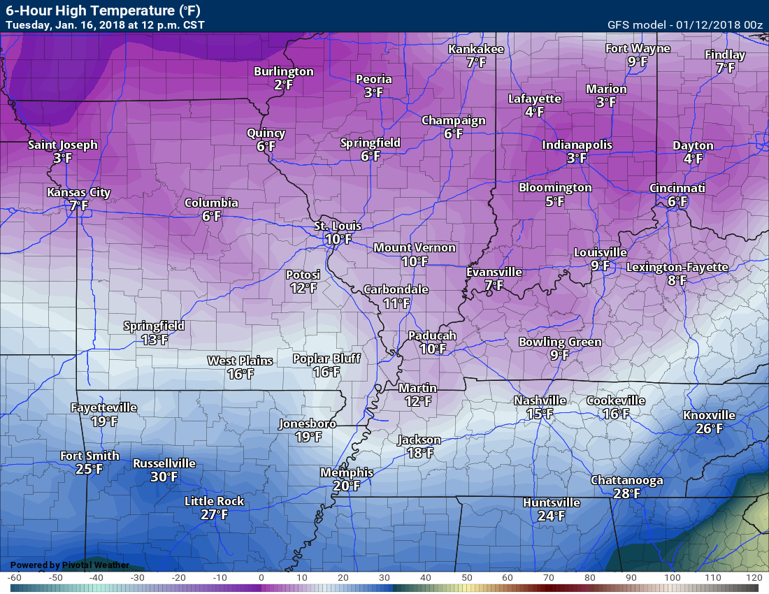
Tuesday 12 PM temperature map
.
.
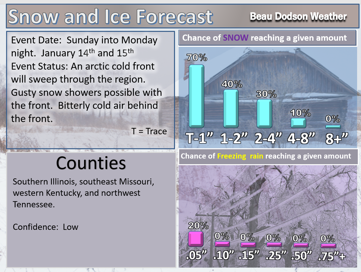
A few snow showers are possible on Sunday and Sunday night.
A strong arctic cold front will arrive on Monday and Tuesday. A band of gusty snow showers may accompany the front. There is the potential for accumulating snow, especially on Monday.
Winds of 30 to 40 mph will accompany the cold front and sharply colder air will follow.
You can expect widespread single digits on Tuesday and Wednesday morning. Winds chills below zero, as well.
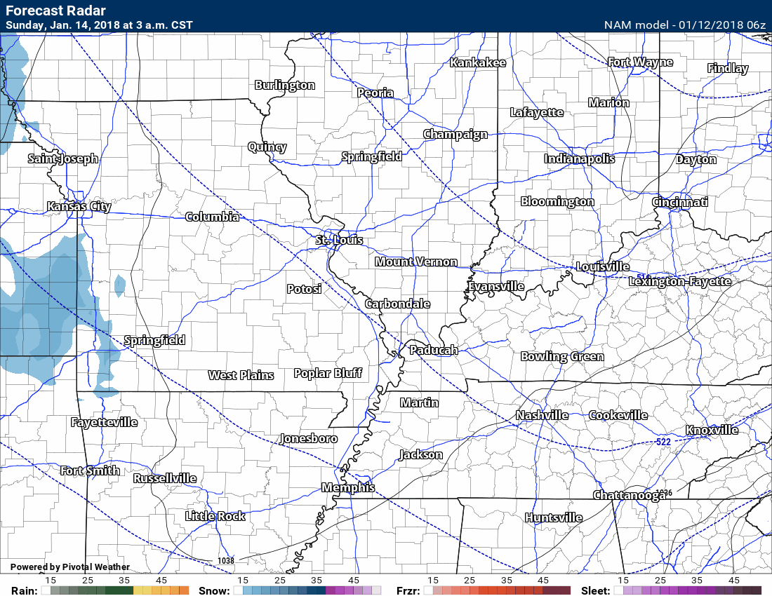
Here is the future-cast radar for Sunday into Monday. You can see that band of precipitation along the front on Monday.
Time stamp upper left hand corner of the animation.
.
.
Beau’s Winter Weather Outlook
.
Sunday and Monday
Monday has the higher chance of producing accumulating snow.
.
.
LONG RANGE OUTLOOKS
These are bonus maps and videos that I bring to you from BAMwx.
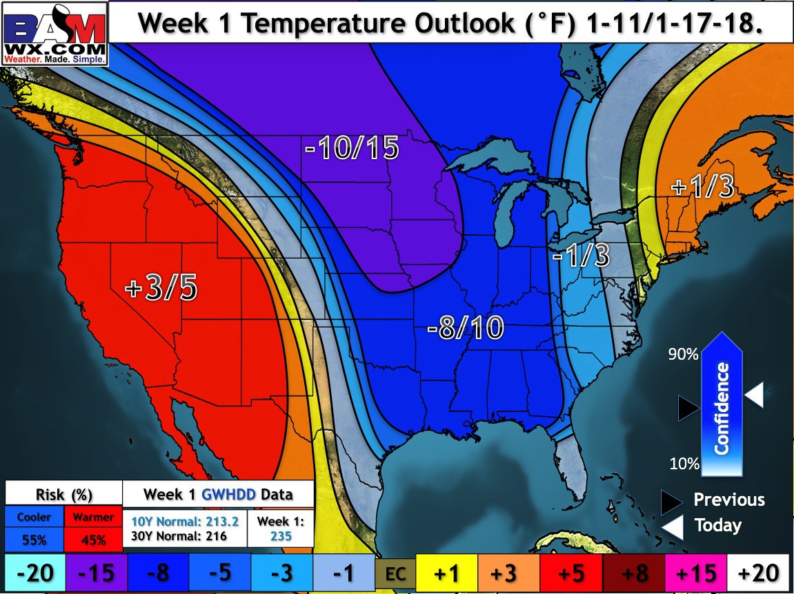
Week one temperature outlook
This graphic covers January 12th through the 19th
We will start off well above normal today. We will then drop well below normal Thursday night into the middle of next week.
These numbers are not the temperature forecast. They represent how many degrees above or below normal temperatures will be. Normal highs are around 47 degrees. Normal lows are around 28 degrees.
Confidence is high
.
.
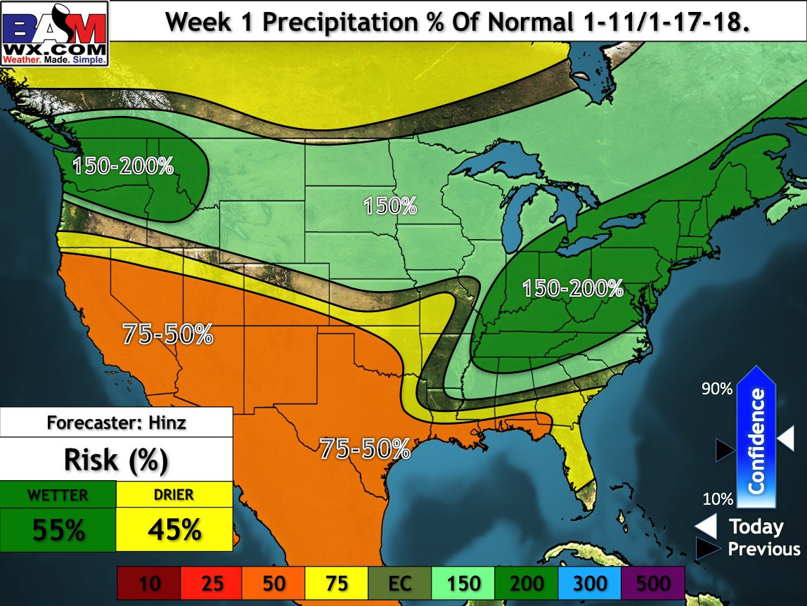
Week one precipitation departure outlook
This graphic covers January 12th through the 19th
Above normal precipitation is anticipated.
Normal rainfall would be around 0.50 to 0.70. 200% of normal would mean 1.00 to 1.40″.
This chart is showing you the % of normal.
Confidence is high
.
.
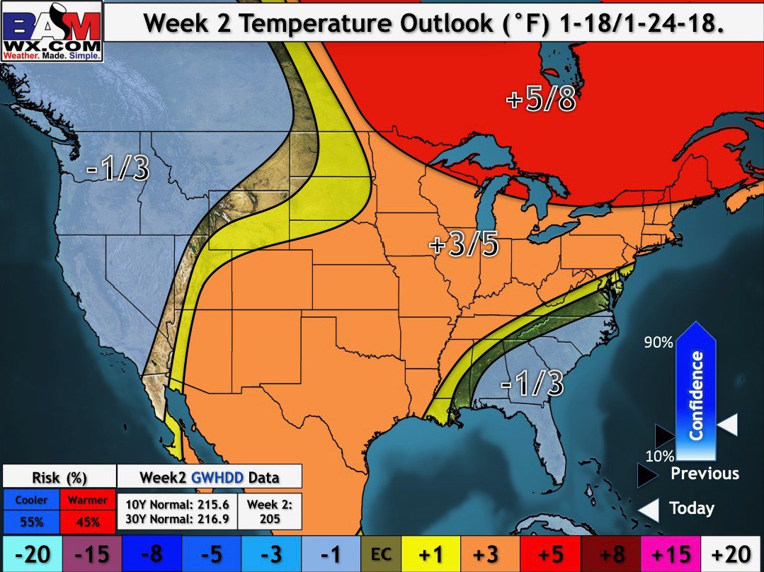
Week two temperature outlook
This graphic covers January 19th through January 25th
The current forecast is for above normal temperatures. We will need to monitor this chart.
Confidence is low
These numbers are not the temperature forecast. They represent how many degrees above or below normal temperatures will be. Normal highs are around 47 degrees. Normal lows are around 28 degrees.
.
.
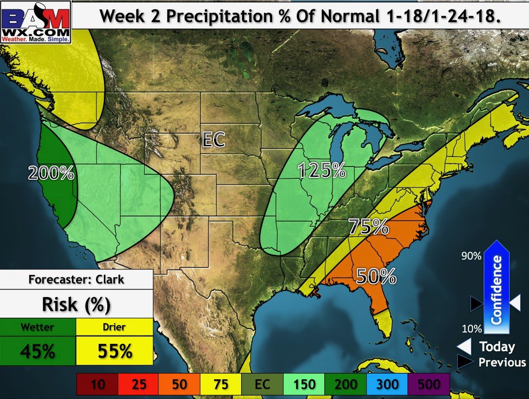
Week two precipitation outlook
This graphic covers January 19th through January 25th
The forecast is for above normal precipitation. Average precipitation is around 0.50″ to 0.70″.
Confidence is low
The % means the percent of normal precipitation. Fifty percent would mean half the normal rainfall during that particular week. 100% would mean normal. 200% would be double the normal precipitation.
.
.
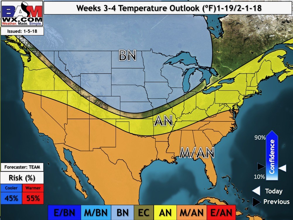
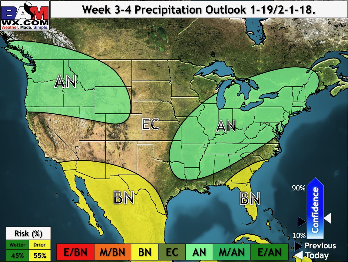
Week three and four temperature and precipitation outlook
This graphic covers January 19th through February 1st
Temperatures are forecast to average above normal. Precipitation is forecast to average above normal.
Confidence is low
M/BM means much below normal
BN means below normal
EC means equal chances of above or below normal precipitation
AN means above normal
M/AN means much above normal
.
.
.
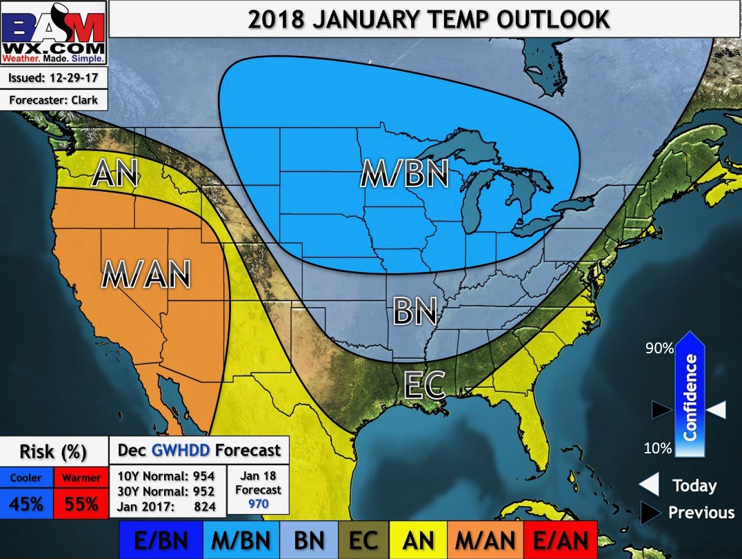
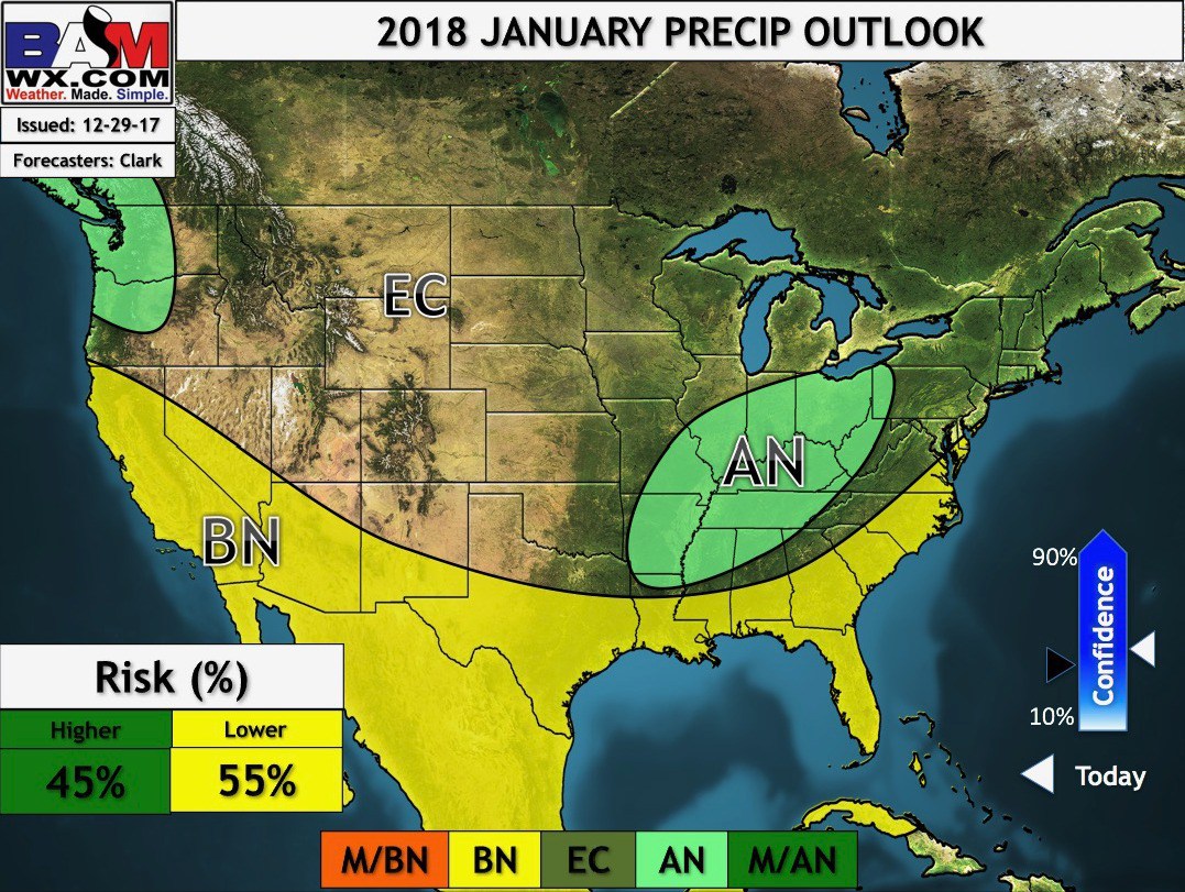
January Temperature and Precipitation Outlook
M/BM means much below normal
BN means below normal
EC means equal chances of above or below normal precipitation
.
.
.
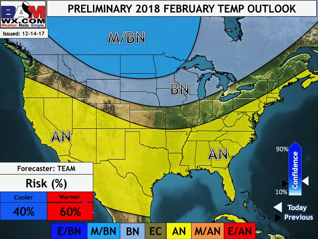
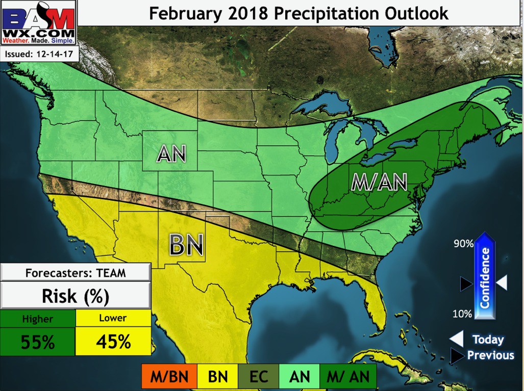
Preliminary February Outlook
.
Temperature
.
.
Precipitation
.
.
Long Range Video update.
Bonus video for subscribers. I bring these to you from the BAMwx team.
This is the long range video update.
This particular video is a bit more technical.
.
Waiting on the BAM team for videos. Will post them when they are available.
.
Illinois centered video (includes portions of Kentucky)
.
Waiting on the BAM team for videos. Will post them when they are available.
.
Missouri Valley centered video
.
Waiting on the BAM team for videos. Will post them when they are available.
.
They currently don’t offer a Kentucky video. That may happen in the future. Use the Illinois video (as it covers the same weather systems)
.

.
January 12, 2018
Winter Storm Alert
Friday Forecast Details
Forecast: Cloudy. Sharply colder. Windy. Freezing rain and sleet. Freezing rain and sleet may end as a brief period of snow. Sleet accumulation of one to two inches possible. Freezing rain accumulation of 0.05″ to 0.15″. Snow accumulation of a dusting to four inches. Locally heavier. I will need to monitor the snow part of the forecast, especially over southeast Illinois and western Kentucky. Some guidance indicates a longer period of snow. Blowing snow likely.
Temperatures: MO ~ 25 to 30 IL ~ 25 to 30 KY ~ 26 to 38 (a wide range of temps possible)
What is the chance of precipitation? MO ~ 60% IL ~ 90% KY ~ 100% TN ~ 100%
Coverage of precipitation: Widespread
Wind chill values: 10 to 20
Accumulating snow or ice: Yes.
Winds: North 10 to 20 mph with gusts to 25 mph with gusts to 38 mph
What impacts are anticipated from the weather? Icy roads. Brief power outages possible. Icy surfaces. Blowing snow.
My confidence in the forecast verifying: High
Is severe weather expected? No
The NWS defines severe weather as 58 mph wind or great, 1″ hail or larger, and/or tornadoes
Should I cancel my outdoor plans? Have a plan B
.
Friday Night Forecast Details:
Winter Storm Alert
Blowing and drifting snow likely.
Forecast: Cloudy. Snow showers possible. Precipitation ending from west to east. Heavy snow possible over the Pennyrile area of western Kentucky. Heavy snow will be ending over the rest of western KY.
Temperatures: MO ~ 14 to 18 IL ~ 12 to 16 KY ~ 10 to 15
What is the chance of precipitation? MO ~ 40% IL ~ 40% KY ~ 80% ending west to east TN ~ 60% ending west to east
Coverage of precipitation: Ending from west to east.
Wind chill values: -5 to 10 above
Accumulating snow or ice: Yes.
Winds: North at 10 to 15 mph with gusts to 30 mph
What impacts are anticipated from the weather? Icy roads and surfaces. Drifting snow. Blowing snow.
My confidence in the forecast verifying: High
Is severe weather expected? No
The NWS defines severe weather as 58 mph wind or great, 1″ hail or larger, and/or tornadoes
Should I cancel my outdoor plans: Have a plan B
.
January 13, 2018
Saturday Forecast Details
Forecast: Mostly cloudy. Colder. Flurries possible.
Temperatures: MO ~ 22 to 26 IL ~ 22 to 25 KY ~ 22 to 25
What is the chance of precipitation? MO ~ 20% IL ~ 20% KY ~ 20% TN ~ 20%
Coverage of precipitation: Spotty snow showers possible.
Wind chill values: 10 to 25
Accumulating snow or ice: Unlikely
Winds: North at 10 to 15 mph
What impacts are anticipated from the weather? Icy roads will remain. Low wind chill values.
My confidence in the forecast verifying: High
Is severe weather expected? No
The NWS defines severe weather as 58 mph wind or great, 1″ hail or larger, and/or tornadoes
Should I cancel my outdoor plans? Have a plan B
.
Saturday Night Forecast Details:
Forecast: Partly cloudy. Cold. Temperatures will vary based on snow and ice cover.
Temperatures: MO ~ 10 to 14 IL ~ 6 to 12 KY ~ 6 to 12
What is the chance of precipitation? MO ~ 0% IL ~ 0% KY ~ 0% TN ~ 0%
Coverage of precipitation: Most likely none. Small chance of flurries.
Wind chill values: -5 to 5
Accumulating snow or ice: No
Winds: North at 6 to 12 mph
What impacts are anticipated from the weather? Icy roads will remain. Low wind chill values.
My confidence in the forecast verifying: High
Is severe weather expected? No
The NWS defines severe weather as 58 mph wind or great, 1″ hail or larger, and/or tornadoes
Should I cancel my outdoor plans: Have a plan B
.
January 14, 2018
Sunday Forecast Details
Forecast: Partly cloudy. Colder. Snow showers possible.
Temperatures: MO ~ 22 to 26 IL ~ 22 to 26 KY ~ 22 to 26
What is the chance of precipitation? MO ~ 20% IL ~ 20% KY ~ 20% TN ~ 20%
Coverage of precipitation: Spotty snow showers possible.
Wind chill values: 10 to 25
Accumulating snow or ice: Monitor
Winds: North at 10 to 15 mph
What impacts are anticipated from the weather? Icy roads will remain. Low wind chill values.n
My confidence in the forecast verifying: Medium
Is severe weather expected? No
The NWS defines severe weather as 58 mph wind or great, 1″ hail or larger, and/or tornadoes
Should I cancel my outdoor plans? Have a plan B
.
Sunday Night Forecast Details:
Forecast: Quite a few clouds. Snow showers possible.
Temperatures: MO ~ 16 to 22 IL ~ 16 to 22 KY ~ 16 to 22
What is the chance of precipitation? MO ~ 20% IL ~ 20% KY ~ 20% TN ~ 20%
Coverage of precipitation: Scattered flurries or snow showers
Wind chill values: -5 to 10
Accumulating snow or ice: Monitor
Winds: Variable at 5 to 10 mph
What impacts are anticipated from the weather? Roads may still be icy
My confidence in the forecast verifying: Medium
Is severe weather expected? No
The NWS defines severe weather as 58 mph wind or great, 1″ hail or larger, and/or tornadoes
Should I cancel my outdoor plans: Have a plan B
.
.
January 15, 2018
Monday Forecast Details
Forecast: Increasing clouds. Cold. A band of snow developing from the north.
Temperatures: MO ~ 32 to 36 IL ~ 28 to 34 KY ~ 28 to 24
What is the chance of precipitation? MO ~ 40% IL ~ 70% KY ~ 60% TN ~ 50%
Coverage of precipitation: A band of precipitation possible moving north to south.
Wind chill values: 18 to 24
Accumulating snow or ice: Yes. One to three inches of snow will be possible.
Winds: Variable at 8 to 16 becoming north at 10 to 20 mph and gusty
What impacts are anticipated from the weather? Icy roads possible. Blowing snow.
My confidence in the forecast verifying: Medium
Is severe weather expected? No
The NWS defines severe weather as 58 mph wind or great, 1″ hail or larger, and/or tornadoes
Should I cancel my outdoor plans? Have a plan B
.
Monday Night Forecast Details:
Forecast: Cloudy with snow showers possible. Bitterly cold.
Temperatures: MO ~ 3 to 8 IL ~ 2 below to 6 above KY ~ 2 below to 8 above
What is the chance of precipitation? MO ~ 30% IL ~ 40% KY ~ 40% TN ~ 40%
Coverage of precipitation: Scattered early
Wind chill values: -12 to 8 above
Accumulating snow or ice: Yes, but ending
Winds: North at 10 to 20 mph
What impacts are anticipated from the weather? Icy roads possible. Bitterly cold air. Low wind chill values.
My confidence in the forecast verifying: Medium
Is severe weather expected? No
The NWS defines severe weather as 58 mph wind or great, 1″ hail or larger, and/or tornadoes
Should I cancel my outdoor plans: Have a plan B
.
January 16, 2018
Tuesday Forecast Details
Forecast: Partly cloudy. Bitterly cold.
Temperatures: MO ~ 16 to 24 IL ~ 16 to 24 KY ~ 16 to 24
What is the chance of precipitation? MO ~ 10% IL ~ 10% KY ~ 10% TN ~ 10%
Coverage of precipitation: Most likely none
Wind chill values: 0 to 10
Accumulating snow or ice: No
Winds: North at 10 to 15 mph
What impacts are anticipated from the weather? Icy roads possible. Bitterly cold air. Low wind chill values.
My confidence in the forecast verifying: Medium
Is severe weather expected? No
The NWS defines severe weather as 58 mph wind or great, 1″ hail or larger, and/or tornadoes
Should I cancel my outdoor plans? Have a plan B
.
Tuesday Night Forecast Details:
Forecast: Mostly clear. Bitterly cold.
Temperatures: MO ~ 4 to 8 IL ~ 4 to 8 KY ~ 5 to 10
What is the chance of precipitation? MO ~ 0% IL ~ 0% KY ~ 0% TN ~ 0%
Coverage of precipitation: None
Wind chill values: -5 to 10
Accumulating snow or ice: No
Winds: North at 5 to 10 mph
What impacts are anticipated from the weather? Icy roads possible. Bitterly cold air. Low wind chill values.
My confidence in the forecast verifying: Medium
Is severe weather expected? No
The NWS defines severe weather as 58 mph wind or great, 1″ hail or larger, and/or tornadoes
Should I cancel my outdoor plans: Have a plan B
.


We offer regional radars and local city radars – if a radar does not update then try another one. Occasional browsers need their cache cleared. You may also try restarting your browser. This will usually fix any problems.
During the winter you can track snow and ice by clicking the winterize button on the local city view interactive radars.
You may email me at beaudodson@usawx.com
Interactive Weather Radar Page. Choose the city nearest your location: Click this link
National interactive radar: Click this link.