8 PM
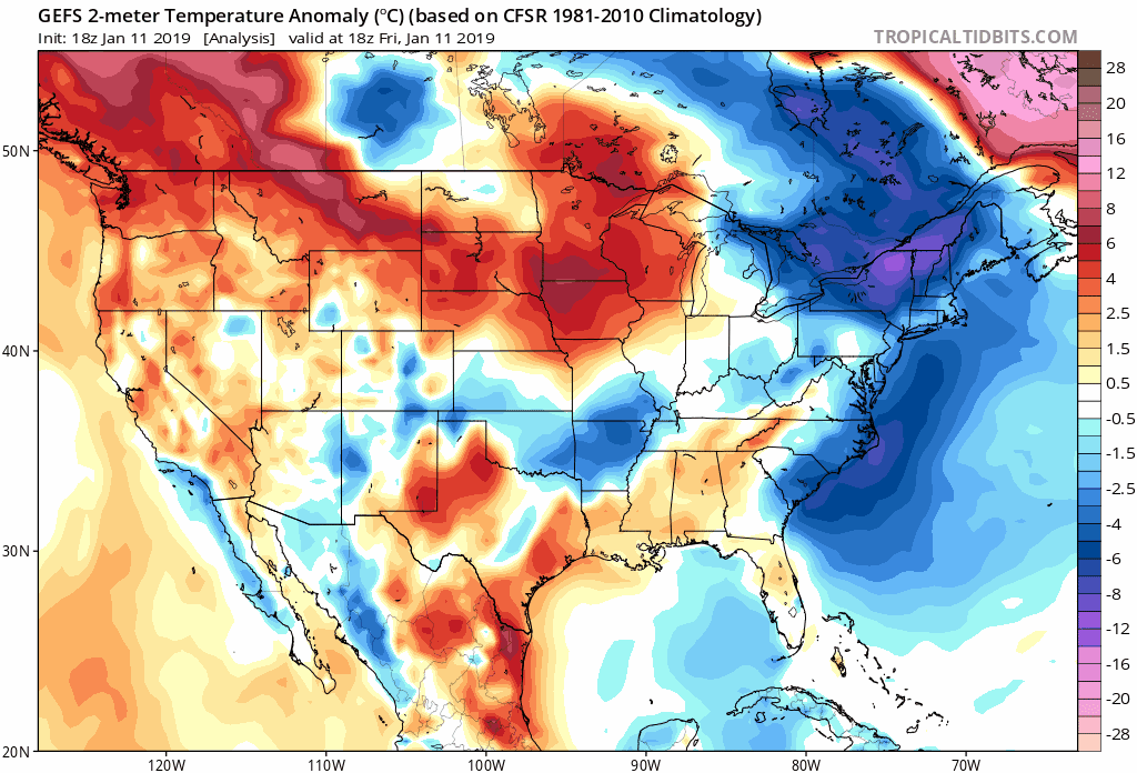
Looking down the road a bit. Check out the long-range GEFS ensembles. These are temperature anomalies.
Winter is coming.
The blue colors represent below normal temperatures. Perhaps much below.
7 PM Update
We have a wide range of precipitation across the region. Rain, snow, sleet, and freezing rain. All of the above.
Temperatures are going to start rising over the coming hours. We are already watching that happen across parts of northeast Arkansas into the Missouri Bootheel. The above freezing temps will work their way north and east through the night.
Snow will change to all rain across the Missouri Bootheel, northwest Tennessee, western Kentucky, and a decent chunk of southern Illinois.
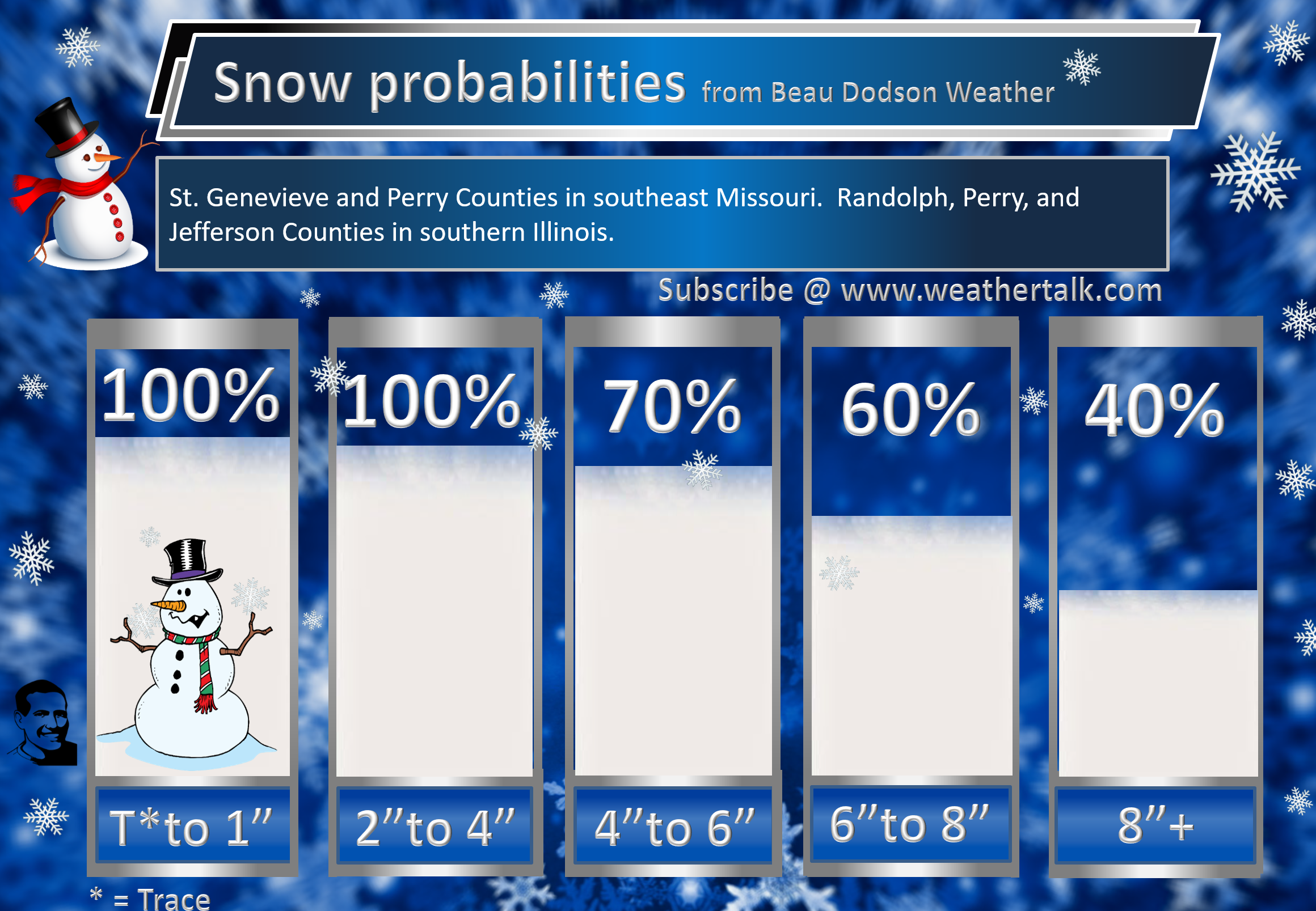
The best chance of snow continuing would be Perry County, Missouri towards Franklin County, Illinois, toward Mt Vernon, Illinois. North and east of there. Temps may remain cold enough for the snow to continue.
A dry slot will work its way into the region overnight. This will shut precip down rather quickly from SW to NE.
Another round of precipitation will develop tomorrow morning. It will mostly be rain in our local area. We will have to watch my extreme NW counties (northern parts of SE MO and northern parts of southern IL). It may remain colder there.
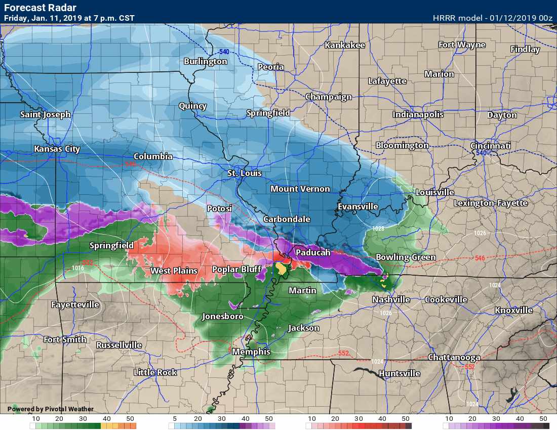
Here is the latest Hrrr model guidance future-cast radar.
Blue is snow. Pink and red are a wintry mix. Green would be rain. Yellow would be moderate rain.
Time-stamp upper left.
Notice that dry slot coming into MO later this evening/tonight and moving northeast? More rain develops tomorrow morning into the afternoon.
We will have to monitor Saturday night’s temperatures and any remaining precipitation. Could be some black ice.
2 PM Update
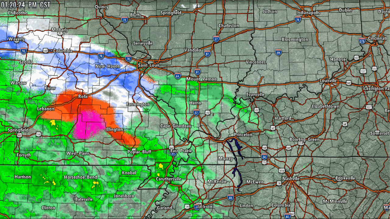
1:20 PM Update
Freezing rain, sleet, snow, and rain are pushing across the area.
Use the winterize button above each city-view radar. That changes to precip type. It won’t be perfect but it is usually close. It is a computer algorithm that determines precip type.

1:2o PM radar animation (see live radars here http://weatherobservatory.com/weather-radar.htm )
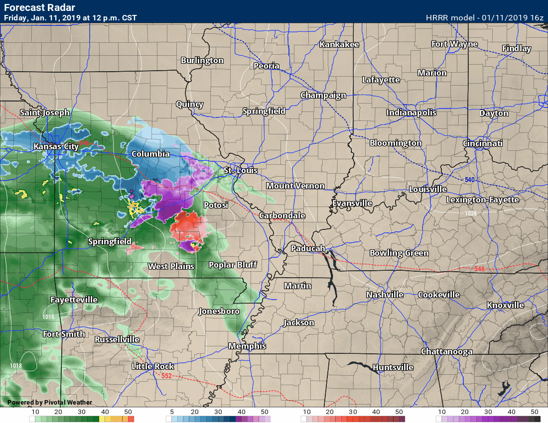
12 PM Future-cast radar
Latest Hrrr future-cast radar. Green is rain (don’t get too caught up near the mix line it could still be frozen even if model shows rain). Blue is snow. Pink/red/purple would be a wintry mix.
10:30 AM video update from the video team
10 AM update
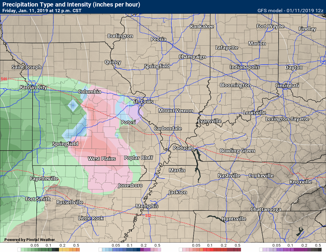
Here is the future-cast GFS model. One of many models. Most models have the same basic theme.
This is showing you what it believes radar will look like. Time-stamp upper left.
Green is rain. Blue is snow. A wintry mix in red/purple.
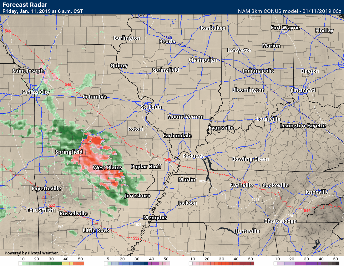
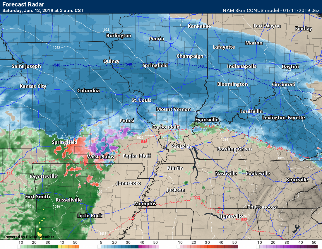
Future-cast radar from the NAM guidance.
Green is rain. Blue is snow. A wintry mix in red/purple.
Note the dry slot shuts everything down late tonight across parts of the region.
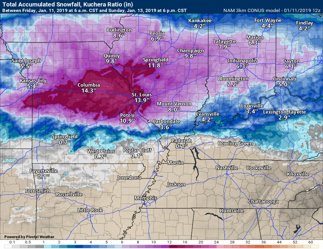
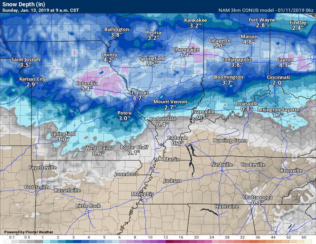
Snow totals from the NAM guidance
Snow depth from the NAM guidance
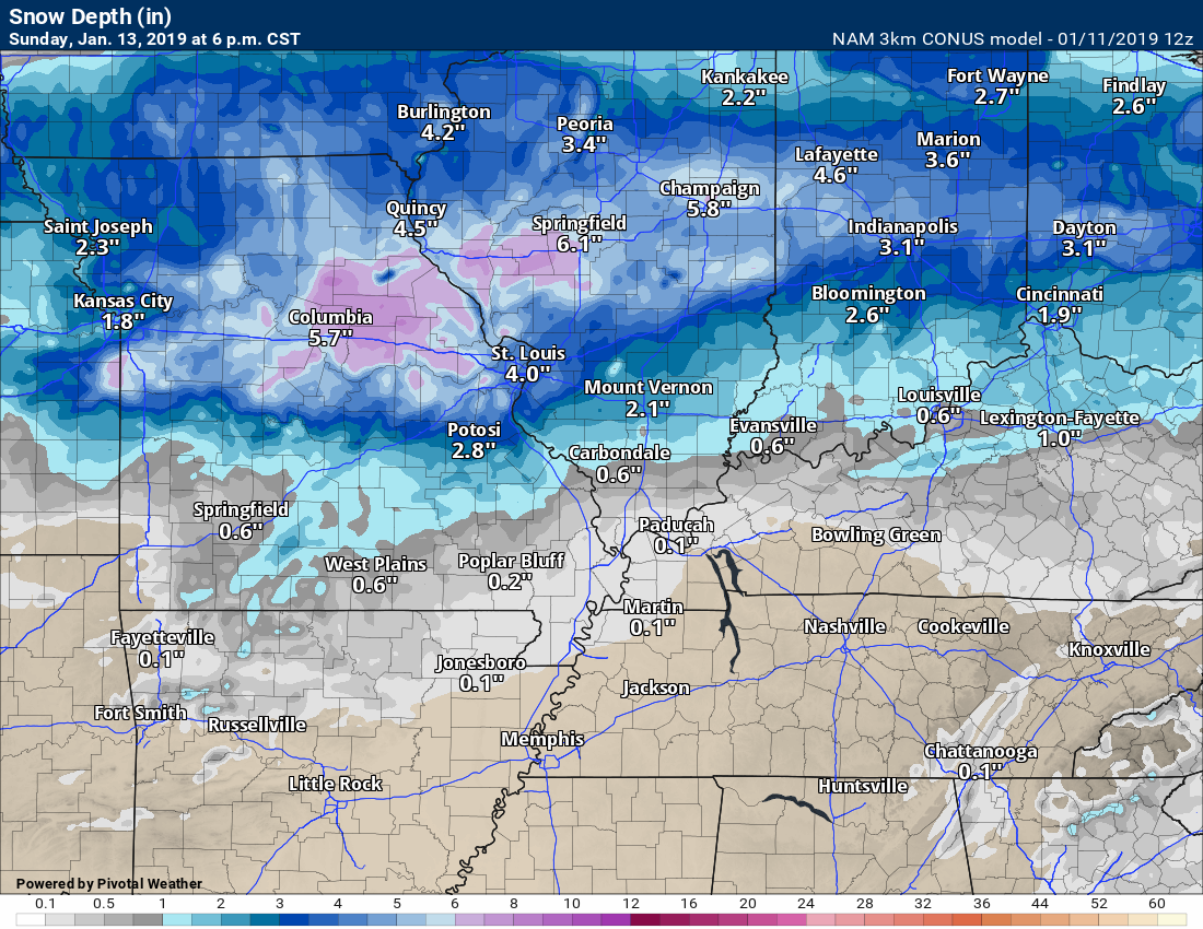
The wet snow will settle. That is why the difference. There may be more snow than this map shows in the heaviest snow area.
I will be updating more frequently over the coming days. I will be live-blogging.
When new information comes in I will post it here on the blog.
New updates will be time-stamped and will appear at the top of the page. Where you are now.

The Justin Croach Memorial Scholarship

Daily WeatherTalk schedule

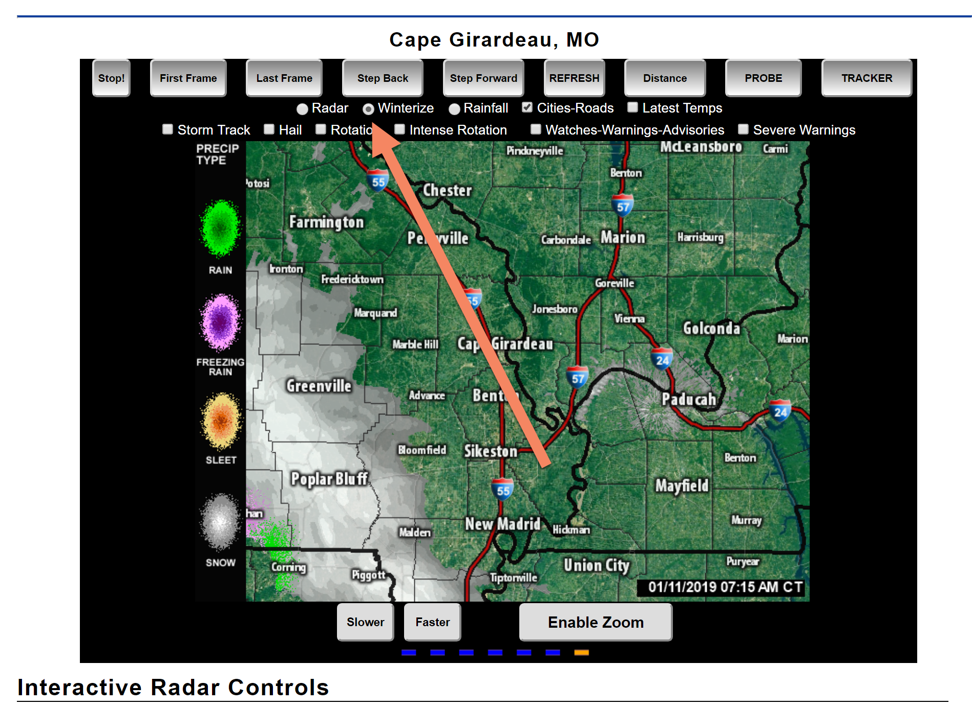
We offer interactive local city view radars and regional radars.
If a radar does not update then try another one. If a radar does not appear to be refreshing then hit Ctrl F5. You may also try restarting your browser.

Interactive Radars:
Interactive live weather radar page. Choose the city nearest your location. If one of the city radars won’t load then try a nearby one. Click here.
Live satellite views. Click here
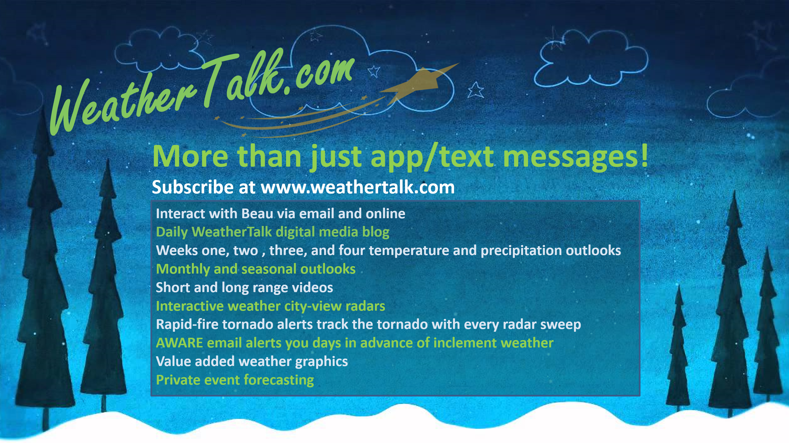
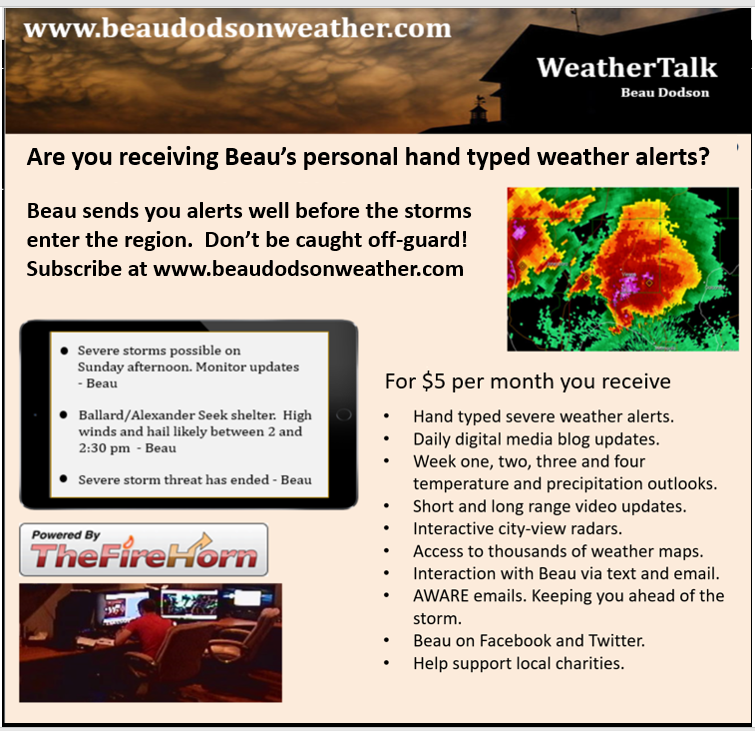
If you are not a subscriber then consider becoming one.
You will receive videos, value-added content, and app / text notifications when I update the blog and Facebook!
Become a subscriber by visiting www.weathertalk.com
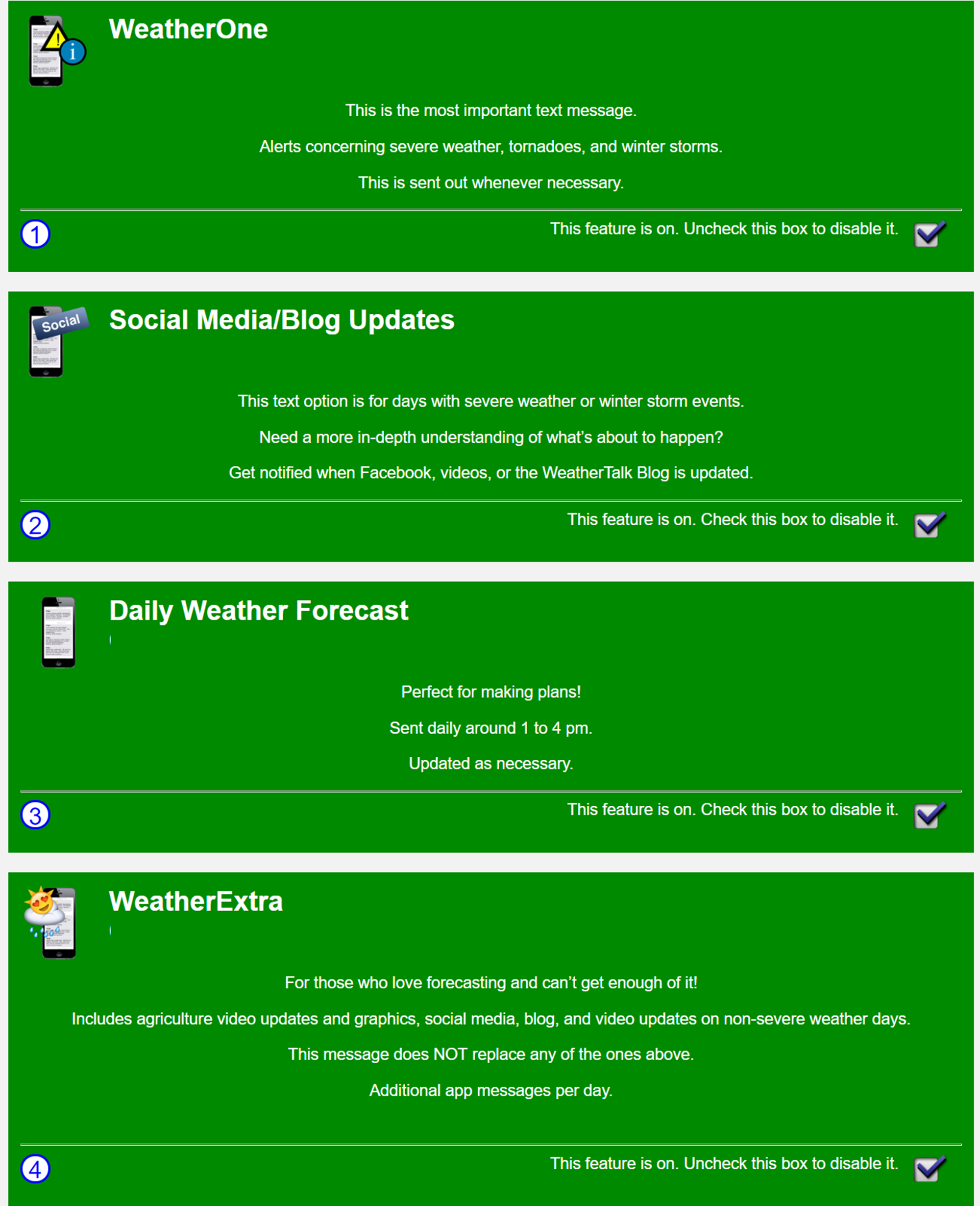
These are the four app/text message options you can activate in your www.weathertalk.com account
January 11, 2019
Friday Forecast: Cloudy. A mixture of rain, freezing rain, sleet, and snow developing across southeast Missouri this morning and then spreading east/northeast through the day. Temperatures will likely rise above freezing in most locations today. Roads are cold. If a wintry mix falls on the roads then it could be an issue. Monitor radars and actual reports as the precip attempts to push eastward.
My confidence in the forecast verifying: Medium (60% confidence in the forecast)
Temperature range: MO ~ 32 to 36 IL ~ 32 to 36 KY ~ 34 to 36 TN ~ 36 to 40
Wind direction and speed: Southeast at 7 to 14 mph
Wind chill (feels like) temperature forecast: 25 to 35
What is the chance/probability of precipitation? MO ~ 90% IL ~ 70% KY ~ 60% over far western Kentucky and 40% over our eastern counties TN ~ 70%
Coverage of precipitation: Increasing coverage west to east.
Is flash flooding anticipated? No
Is accumulating snow or ice anticipated? A wintry mix is likely today. Temperatures in many areas will rise above freezing later this morning. Roads are cold so this could be an issue if precipitation does occur in your area.
Is non-accumulating snow or ice anticipated? Yes
Are icy road conditions anticipated? Yes. Road surfaces are cold. Precipitation falling onto the roads could cause slick spots.
Is severe weather expected? No
The NWS officially defines severe weather as 58 mph wind or great, 1″ hail or larger, and/or tornadoes
Will lightning be possible? No
What impacts are anticipated from the weather? Wet roadways. Monitor icy road potential in areas with wintry precip.
Should I cancel my outdoor plans? Have a plan B and monitor radars and ground reports
Will the weather impact my outdoor plans? Chilly temperatures will make it uncomfortable outside. Increasing chances of rain and a wintry mix will make for damp conditions over parts of the region as we move through the day.
UV Index: 1 to 2 Low
Sunrise: 7:10 AM
Friday Night Forecast Details:
Forecast: A dry slot arrives late tonight and that will shut down precipitation from south to north across at least the Bootheel into extreme southern Illinois, western Kentucky, and northwest Tennessee. Cloudy. Heavy wet snow for some of my forecast counties. See graphics below. Otherwise, a chance of rain, snow, and sleet. Some wet accumulation likely, esp across southeast Missouri and southern Illinois. Some lighter accumulation possible elsewhere. If evaporational cooling occurs then the snow totals will increase in other counties, as well. This remains a question. See graphics below for my first forecast thoughts on this system. Temperatures slowly rising towards morning.
My confidence in the forecast verifying: High (80% confidence in the forecast)
Temperature range: MO ~ 28 to 32 IL ~ 28 to 32 KY ~ 32 to 34 TN ~ 32 to 34
Wind direction and speed: East and southeast at 7 to 14 mph
Wind chill (feels like) temperature forecast: 25 to 35
What is the chance/probability of precipitation? MO ~ 100% IL ~ 100% KY ~ 80% TN ~ 80%
Coverage of precipitation: Becoming widespread
Is flash flooding anticipated? No
Is accumulating snow or ice anticipated? Yes
Is non-accumulating snow or ice anticipated? Yes
Are icy road conditions anticipated? Yes, some areas may experience icy road conditions.
Is severe weather expected? No
The NWS officially defines severe weather as 58 mph wind or great, 1″ hail or larger, and/or tornadoes
Will lightning be possible? Unlikely
Should I cancel my outdoor plans? Have a plan B
What impacts are anticipated from the weather? Icy roads and wet roads. Power lines could sag or break in the heaviest snow band.
Will the weather impact my outdoor plans? Yes. Snow and rain will cause for damp and cold conditions. Icy roads may be a concern in some locations, as well.
Sunset: 4:57 PM
Moonrise: 10:32 AM Waxing Crescent
Moonset: 10:13 PM
January 12, 2019
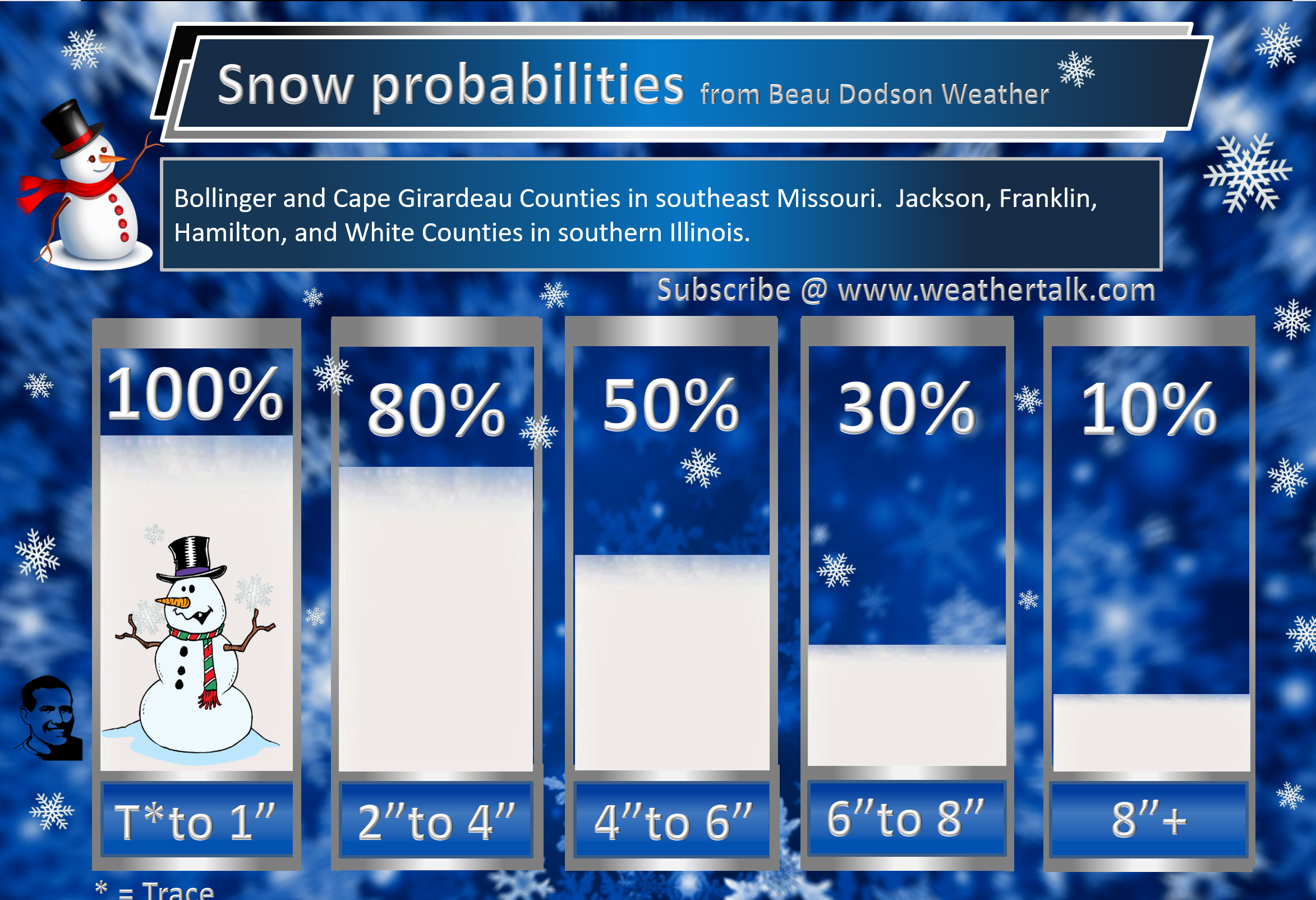
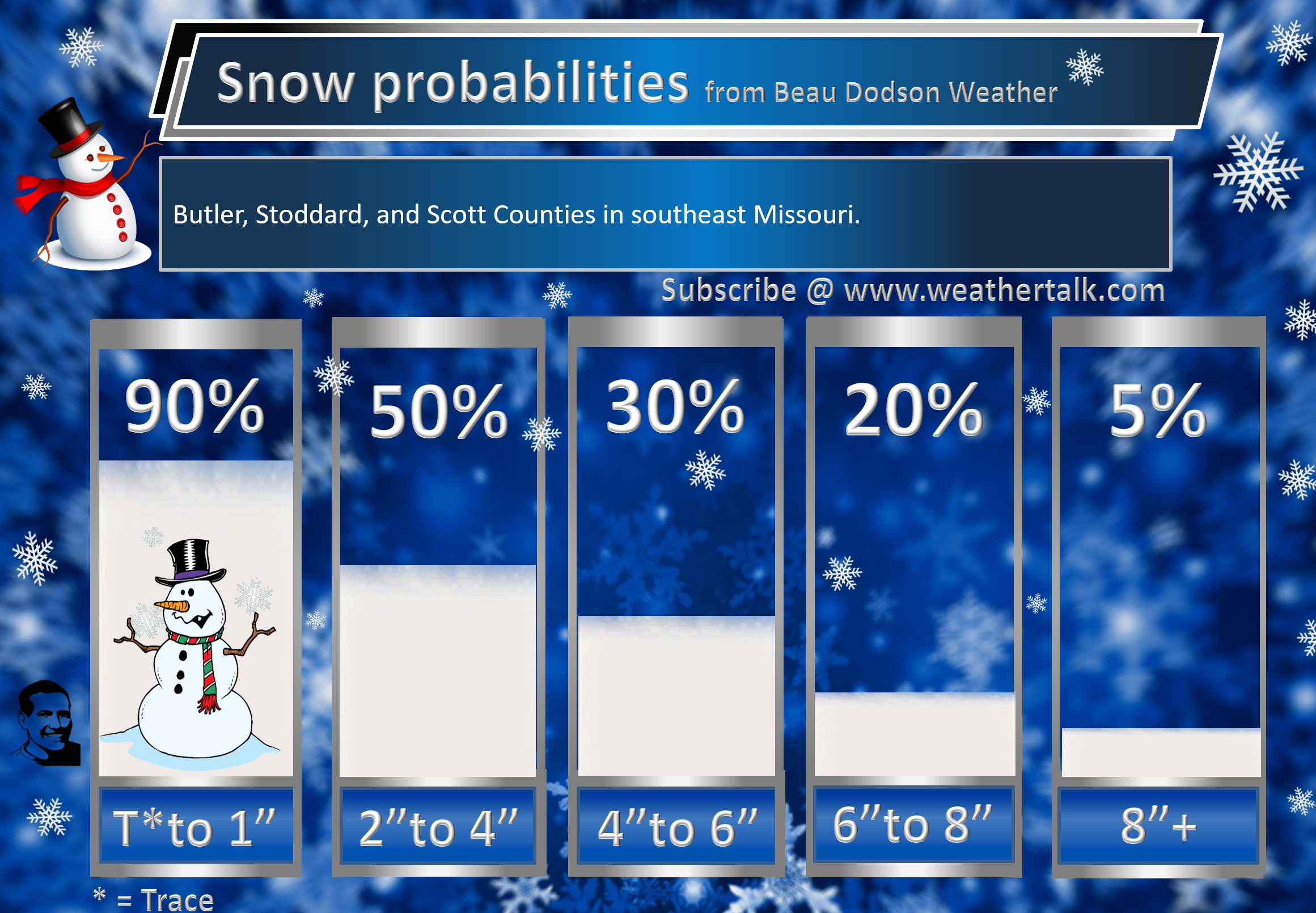
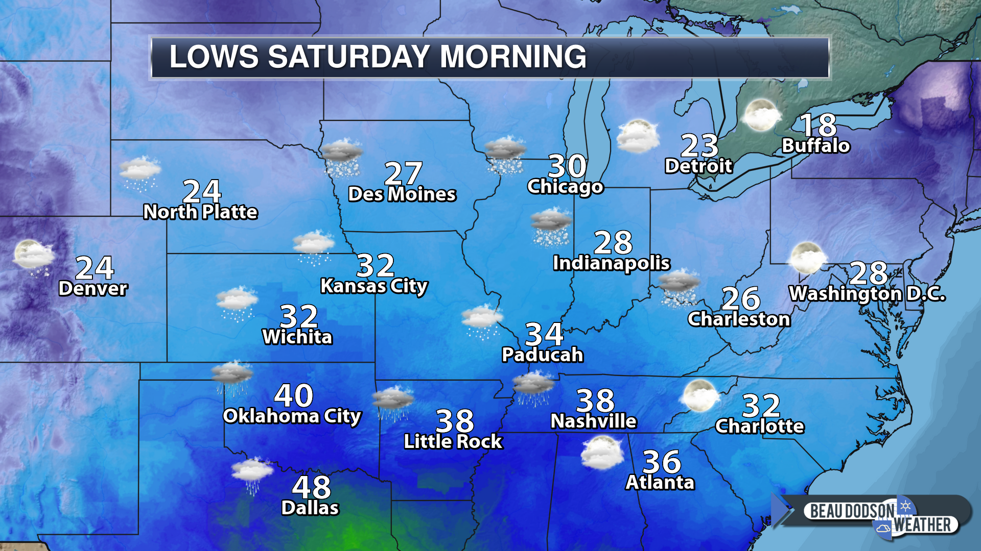
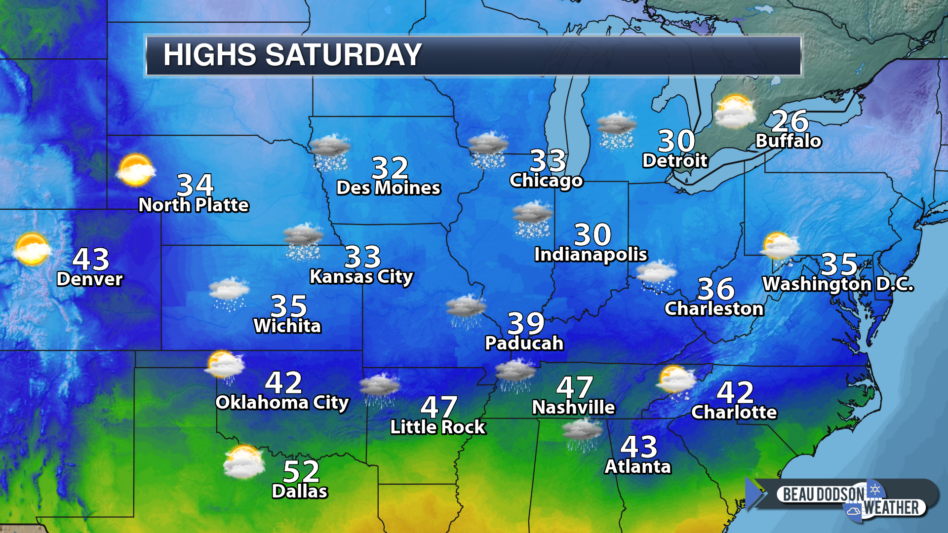
Saturday Forecast: I will be monitoring a dry slot that could work into the region tomorrow morning. That will shut down the precipitation. This is most likely from the Missouri Bootheel into extreme southern Illinois, western Kentucky, and northwest Tennessee. Cloudy. Rain and snow likely. Heavy wet snow for some. Some areas will change over to all rain. That would melt any snow accumulation that occurred Friday night. Parts of southeast Missouri and southern Illinois may remain snow through most of the event. That would most likely be from Perry County, Missouri northeast towards Jefferson County, Illinois. From there north and west stand the greatest chance of remaining snow. Elsewhere, snow will mix with and change to rain.
My confidence in the forecast verifying: Medium (60% confidence in the forecast)
Temperature range: MO ~ 34 to 40 IL ~ 32 to 40 KY ~ 36 to 40 TN ~ 38 to 42
Wind direction and speed: East and northeast at 7 to 14 mph
Wind chill (feels like) temperature forecast: 20 to 30
What is the chance/probability of precipitation? MO ~ 80% IL ~ 90% KY ~ 70% TN ~ 70%
Coverage of precipitation: Widespread during the morning. Becoming more scattered over parts of the region as a dry slot works its way into the region.
Is flash flooding anticipated? No
Is accumulating snow or ice anticipated? Yes
Is non-accumulating snow or ice anticipated? Yes
Are icy road conditions anticipated? Saturday morning could deliver some snow packed roads. Roads should improve rather quickly as temperatures rise above freezing across most of my forecast area.
Is severe weather expected? No
The NWS officially defines severe weather as 58 mph wind or great, 1″ hail or larger, and/or tornadoes
Will lightning be possible? No
Should I cancel my outdoor plans? Have a plan B
What impacts are anticipated from the weather? Icy roads and wet roads. Power lines could break in the heaviest wet snow band.
Will the weather impact my outdoor plans? Yes. Snow and rain will cause for damp and cold conditions. Icy roads may be a concern in some locations, as well.
UV Index: 1 Low
Sunrise: 7:09 AM
Saturday Night Forecast Details:
Forecast: Cloudy. A chance of rain and snow showers.
My confidence in the forecast verifying: Medium (60% confidence in the forecast)
Temperature range: MO ~ 30 to 34 IL ~ 30 to 36 KY ~ 34 to 38 TN ~ 36 to 40
Wind direction and speed: North at 6 to 12 mph
Wind chill (feels like) temperature forecast: 25 to 35
What is the chance/probability of precipitation? MO ~ 70% IL ~ 70% KY ~ 60% TN ~ 60%
Coverage of precipitation: Perhaps numerous early. Becoming scattered.
Is flash flooding anticipated? No
Is accumulating snow or ice anticipated? Possible across northern parts of southeast Missouri and northern portions of southern Illinois. Elsewhere, temperatures will be marginal or too warm for accumulation.
Is non-accumulating snow or ice anticipated? Yes
Are icy road conditions anticipated? Possible across northern parts of southeast Missouri and northern portions of southern Illinois. Temperatures will be marginal for freezing.
Is severe weather expected? No
The NWS officially defines severe weather as 58 mph wind or great, 1″ hail or larger, and/or tornadoes
Will lightning be possible? No
Should I cancel my outdoor plans? Have a plan B
What impacts are anticipated from the weather? Damp road conditions. Possibly ice road conditions in some areas.
Will the weather impact my outdoor plans? Yes. Snow and rain will cause for damp and cold conditions. Icy roads may be a concern in some locations, as well.
Sunset: 4:58 PM
Moonrise: 11:00 AM Waxing Crescent
Moonset: 11:10 PM
January 13, 2019
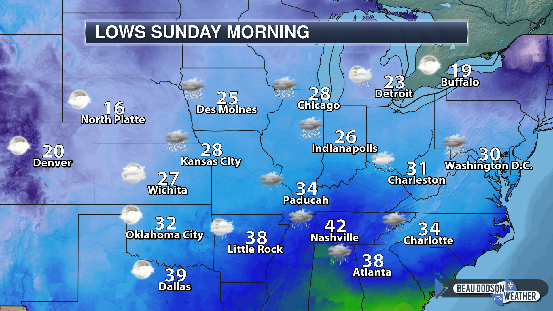
Sunday Forecast: Mostly cloudy. A few scattered rain or snow showers. Freezing drizzle possible over northern parts of southeast Missouri and northern parts of southern Illinois. Monitor updates.
My confidence in the forecast verifying: Medium (40% confidence in the forecast)
Temperature range: MO ~ 34 to 40 IL ~ 32 to 40 KY ~ 36 to 42 TN ~ 38 to 42
Wind direction and speed: North at 7 to 14 mph with gusts to 20 mph
Wind chill (feels like) temperature forecast: 20 to 30
What is the chance/probability of precipitation? MO ~ 30% IL ~ 50% KY ~ 40% TN ~ 40%
Coverage of precipitation: Scattered to perhaps widespread (greater coverage over northern counties)
Is flash flooding anticipated? No
Is accumulating snow or ice anticipated? Some light icing possible. Some additional light snow accumulation mainly over northern parts of southeast Missouri, northern parts of southern Illinois, northern parts of west Kentucky (closer to Owensboro). It may be too warm for accumulation. I am monitoring temperatures.
Is non-accumulating snow or ice anticipated? Yes
Are icy road conditions anticipated? Most areas will not have icy roads
Is severe weather expected? No
The NWS officially defines severe weather as 58 mph wind or great, 1″ hail or larger, and/or tornadoes
Will lightning be possible? No
Should I cancel my outdoor plans? Have a plan B
What impacts are anticipated from the weather? Wet road conditions.
Will the weather impact my outdoor plans? Damp and chilly conditions
UV Index: 2 Low
Sunrise: 7:09 AM
Sunday Night Forecast Details:
Forecast: Partly cloudy. Snow flurries possible. Temperatures will be highly dependent on snow cover.
My confidence in the forecast verifying: Medium (60% confidence in the forecast)
Temperature range: MO ~ 22 to 26 IL ~ 20 to 26 KY ~ 26 to 28 TN ~ 28 to 30
Wind direction and speed: North 5 to 10 mph
Wind chill (feels like) temperature forecast: 20 to 30
What is the chance/probability of precipitation? MO ~ 20% IL ~ 30% KY ~ 30% TN ~ 20%
Coverage of precipitation: None to scattered
Is flash flooding anticipated? No
Is accumulating snow or ice anticipated? No
Is non-accumulating snow or ice anticipated? A flurry possible
Are icy road conditions anticipated? No
Is severe weather expected? No
The NWS officially defines severe weather as 58 mph wind or great, 1″ hail or larger, and/or tornadoes
Will lightning be possible? No
Should I cancel my outdoor plans? No
What impacts are anticipated from the weather? Monitor road conditions in areas that received snow on Friday night and Saturday.
Will the weather impact my outdoor plans? Damp conditions. Chilly conditions.
Sunset: 4:59 PM
Moonrise: 11:29 AM First Quarter
Moonset: 12:01 AM
Learn more about the UV index readings. Click here.
Wind forecast


Friday 11th: A mixture of rain, freezing rain, sleet, and snow. The greatest chance of impacts would be southeast Missouri and southwest Illinois. Roads are cold. Precipitation falling onto the cold roads could cause icy spots. Monitor trends.
Friday Night: Yes. Snow and a wintry mix are likely across parts of southeast Missouri and southern Illinois. Elsewhere, a mixture of rain and wet snow likely, as well. Monitor updates. Temperatures should rise above freezing in many areas late tonight. Parts of the Bootheel, far southwest Kentucky, and northwest Tennessee may be above freezing all night.
Saturday 12th: Yes. Wet snow and a wintry mix are possible across mainly northern parts of southeast Missouri and portions of southern Illinois before changing to rain. Elsewhere, rain is likely perhaps mixed with snow. A dry slot works its way into the area by morning. That will shut down precip for many areas.
Saturday night: Snow showers are possible.
Sunday 13th: Snow flurries are possible.
Monday 14th: Wintry precipitation is not anticipated.
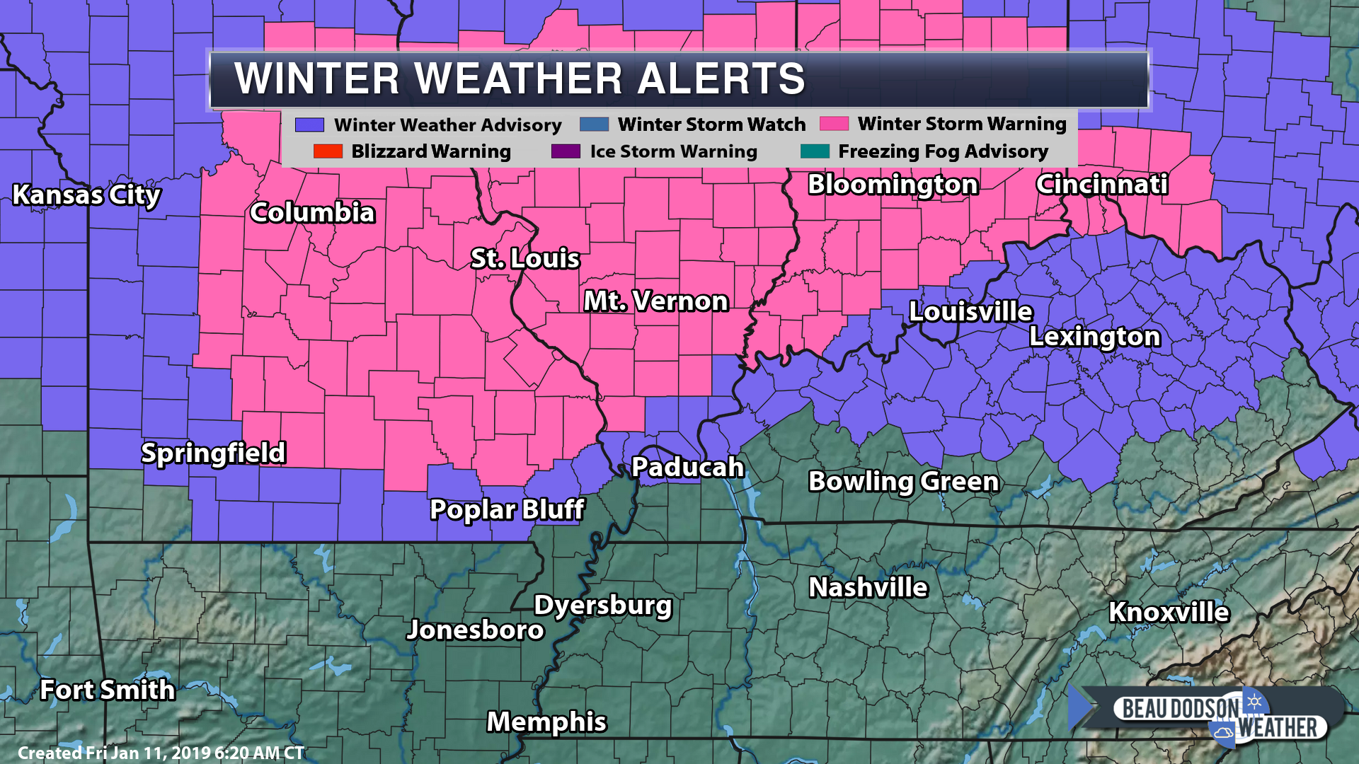
Winter storm warnings in the pink (mainly for this afternoon into early tomorrow morning)
Purple is a winter weather advisory. Locally, that will be today into tomorrow morning. Temperatures rise tonight and snow changes to rain in many areas (purple zone in our area, especially)

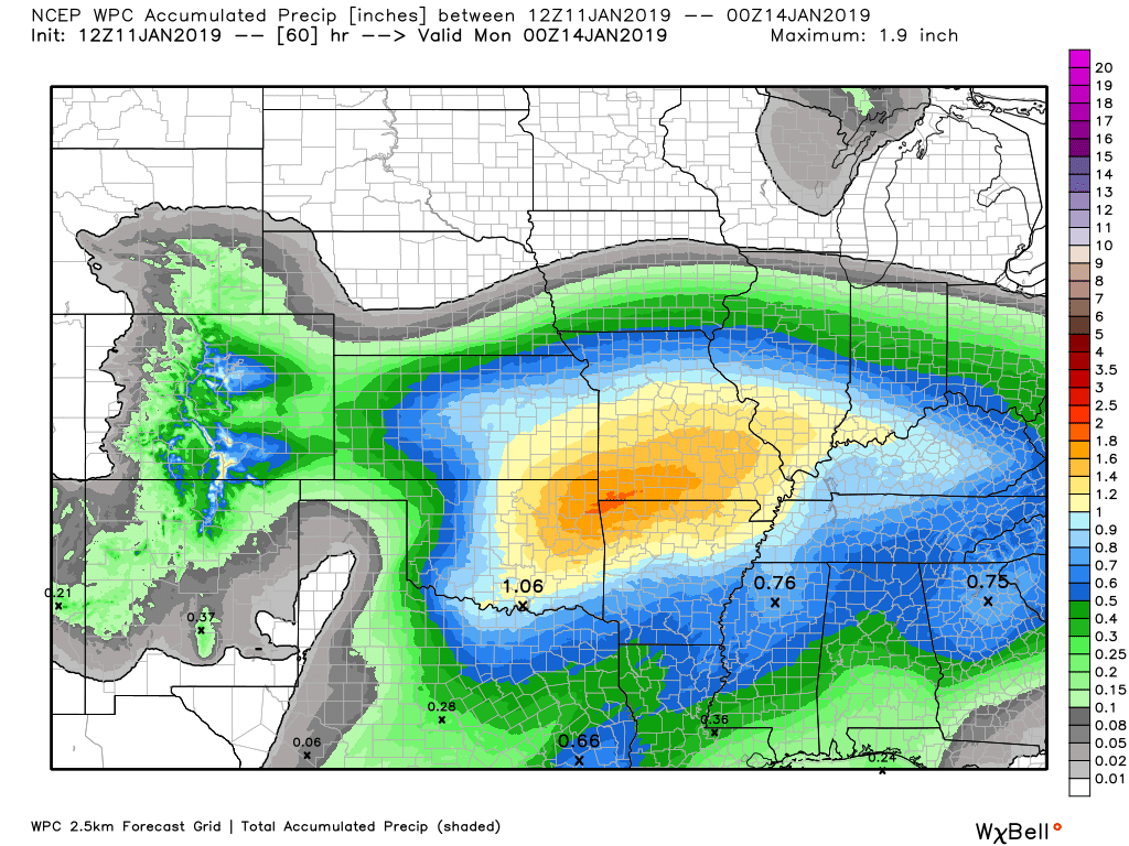
Here is the WPC/NOAA rainfall outlook.
Precipitation chances ramp up today into Saturday night/Sunday
Here are the current forecast totals in liquid. Remember, ten inches of snow equals around one-inch liquid.
This map shows you liquid and does not assume precipitation type.
This is melted precipitation.
Click to enlarge
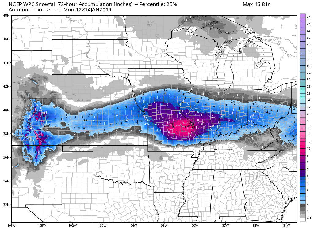
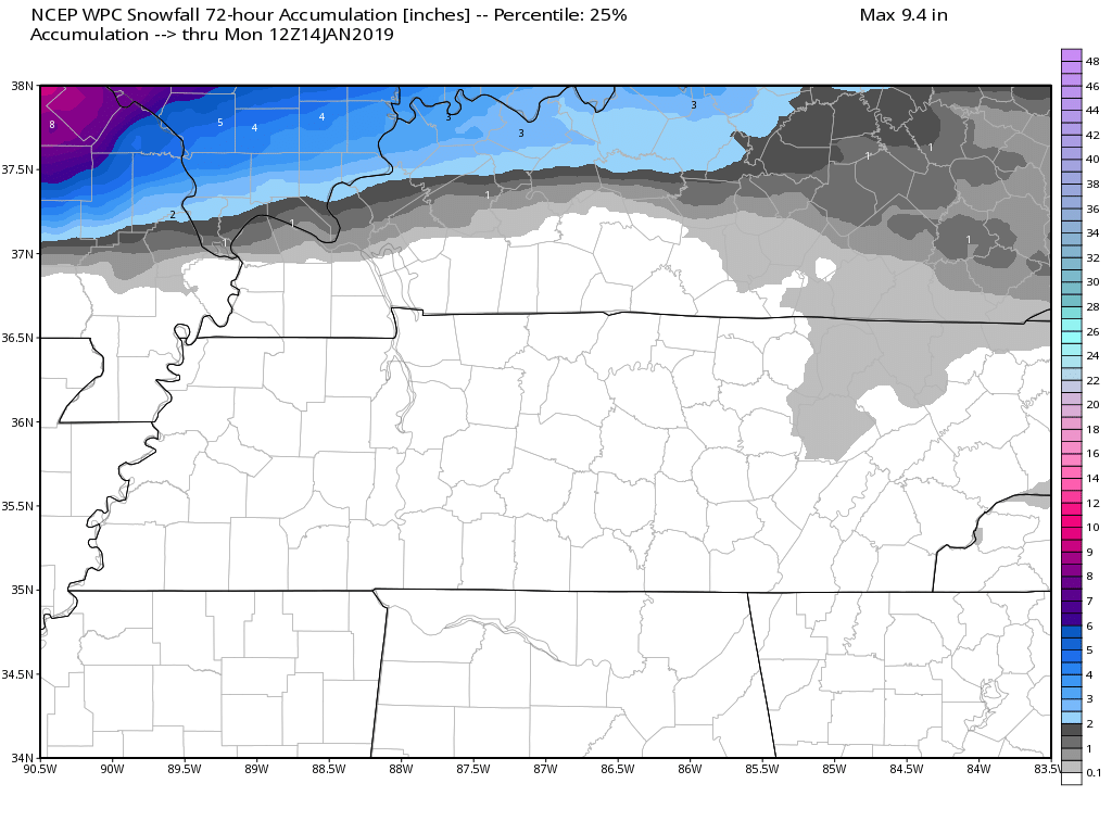
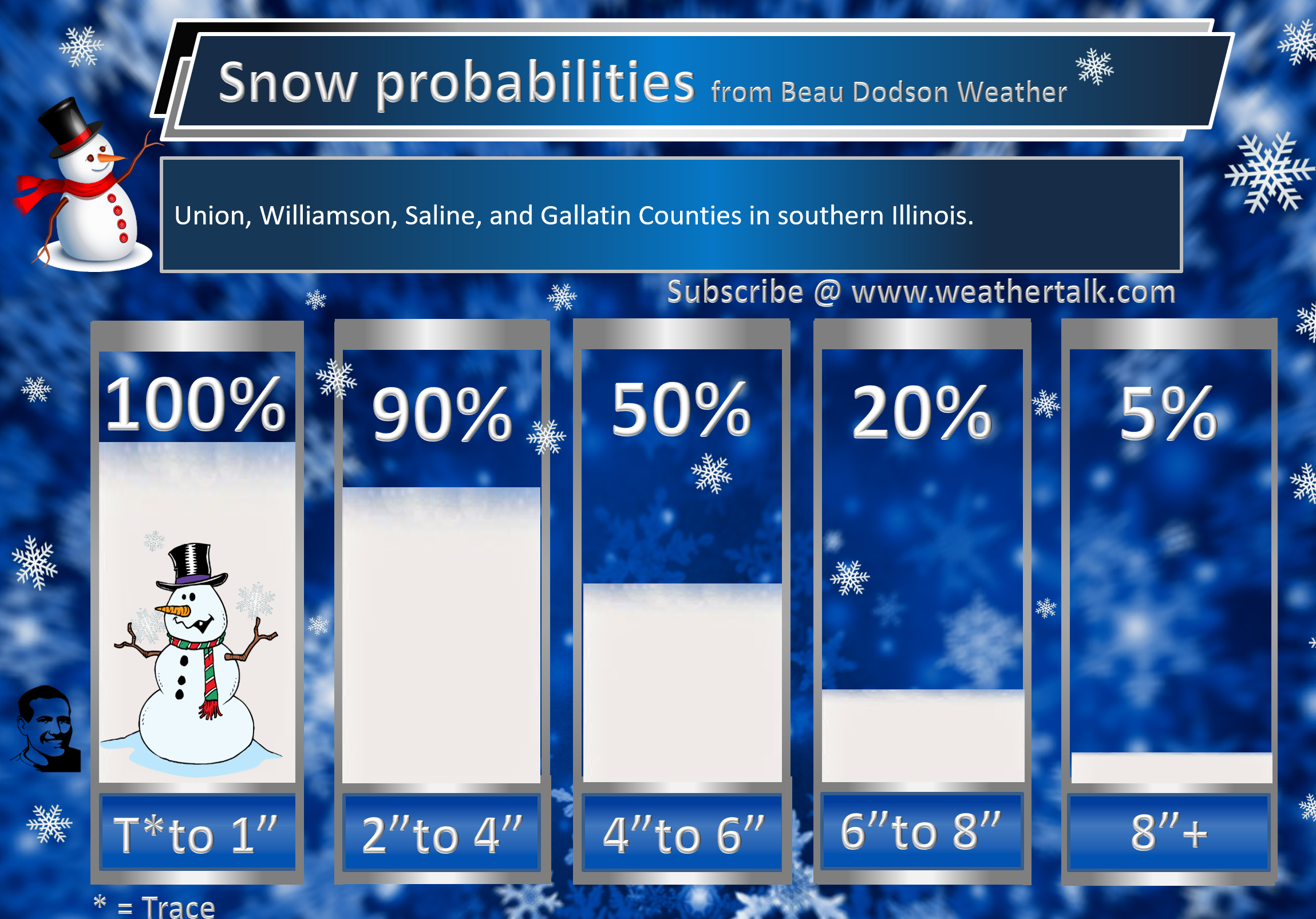
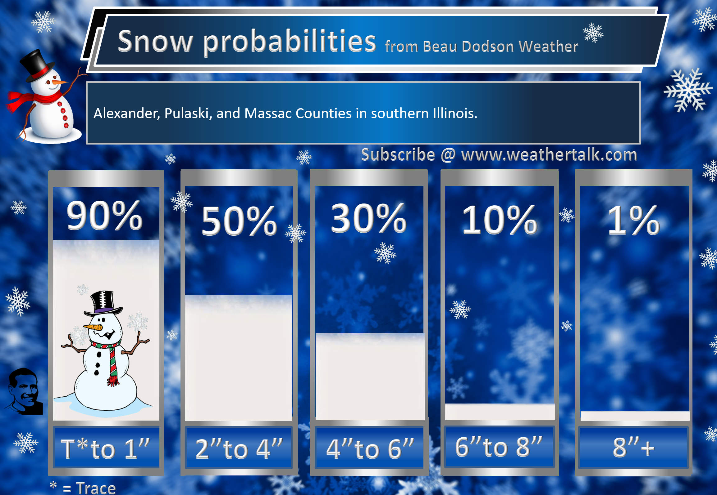
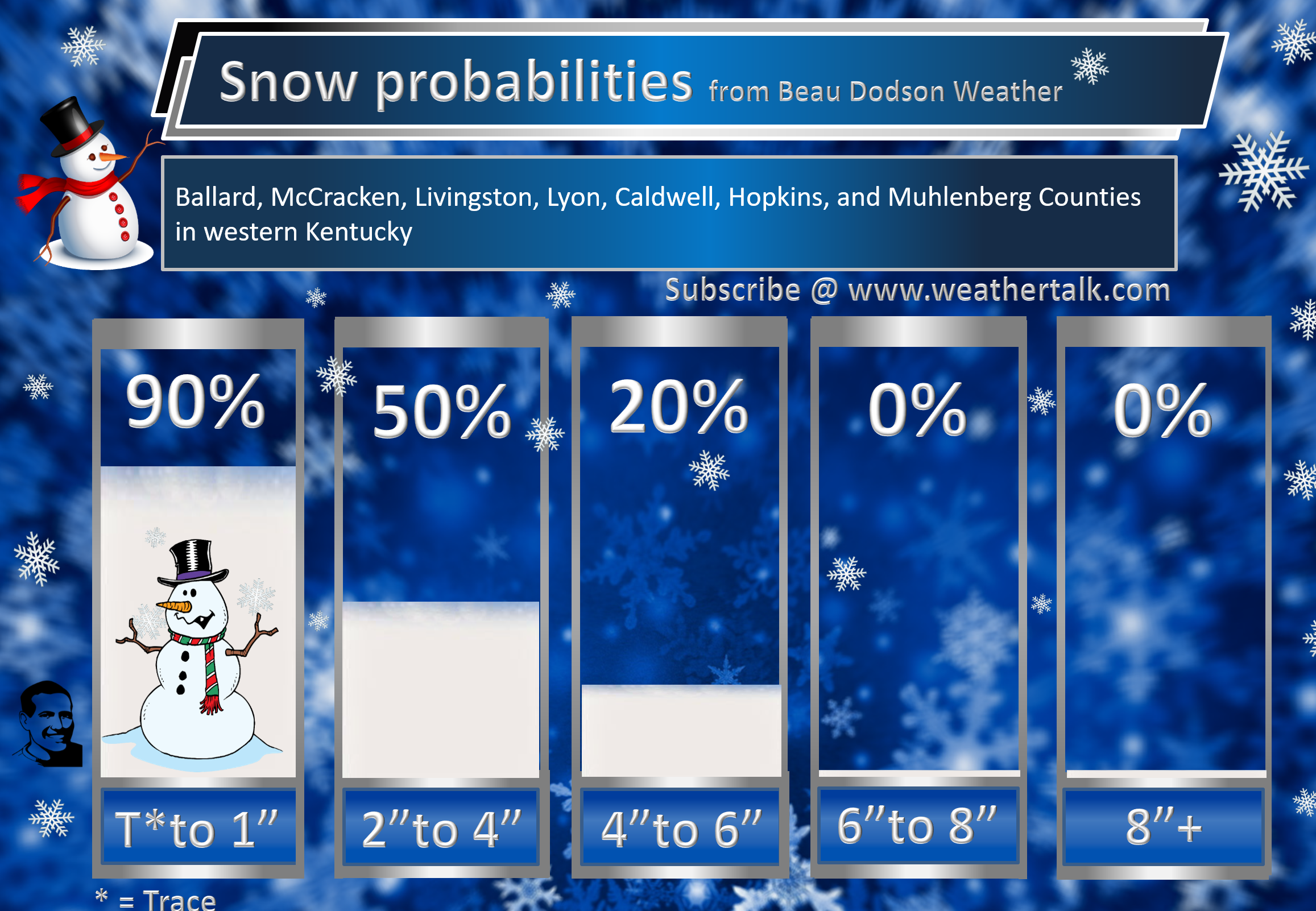
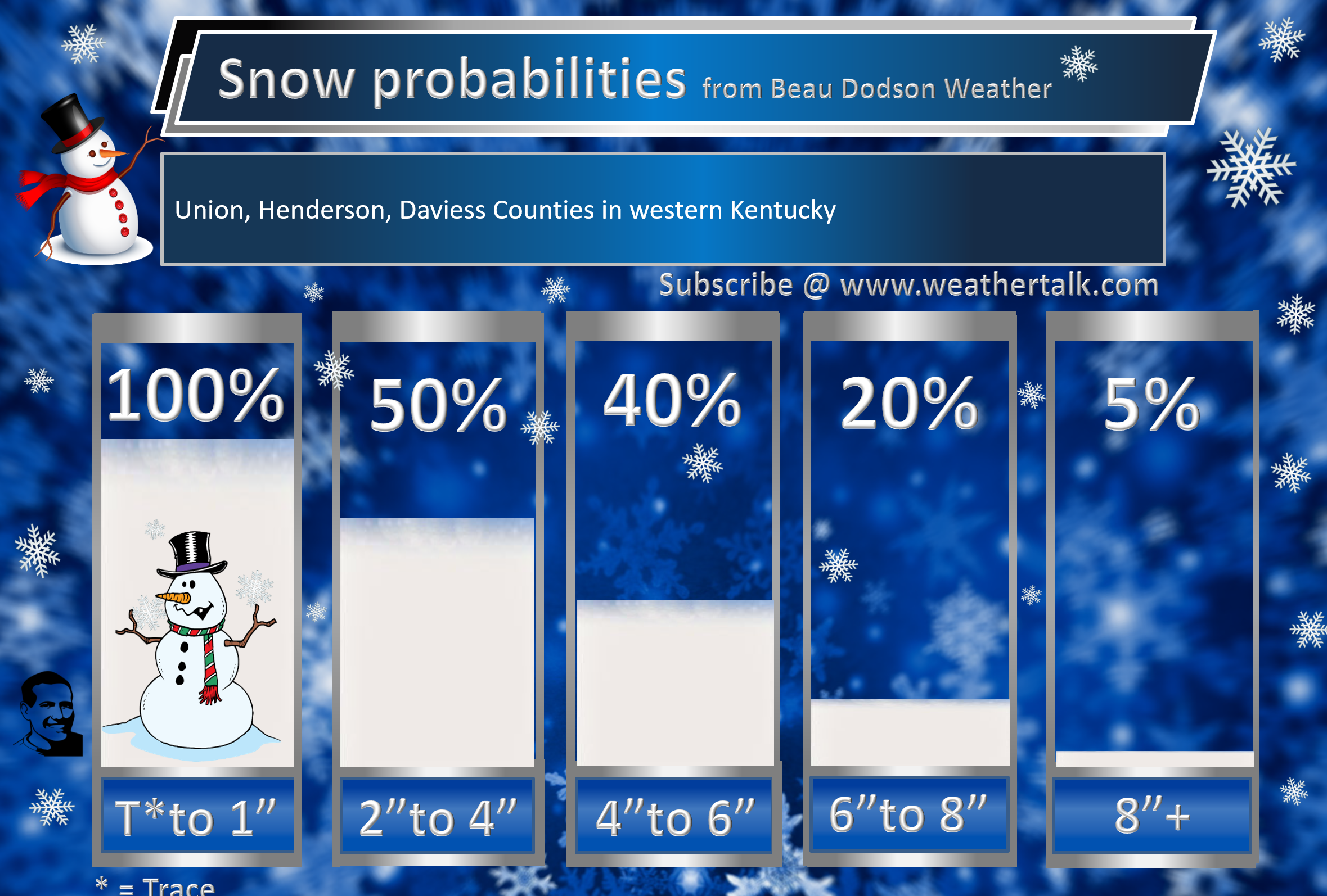
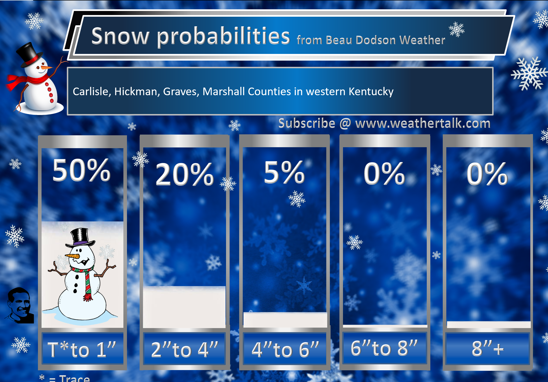
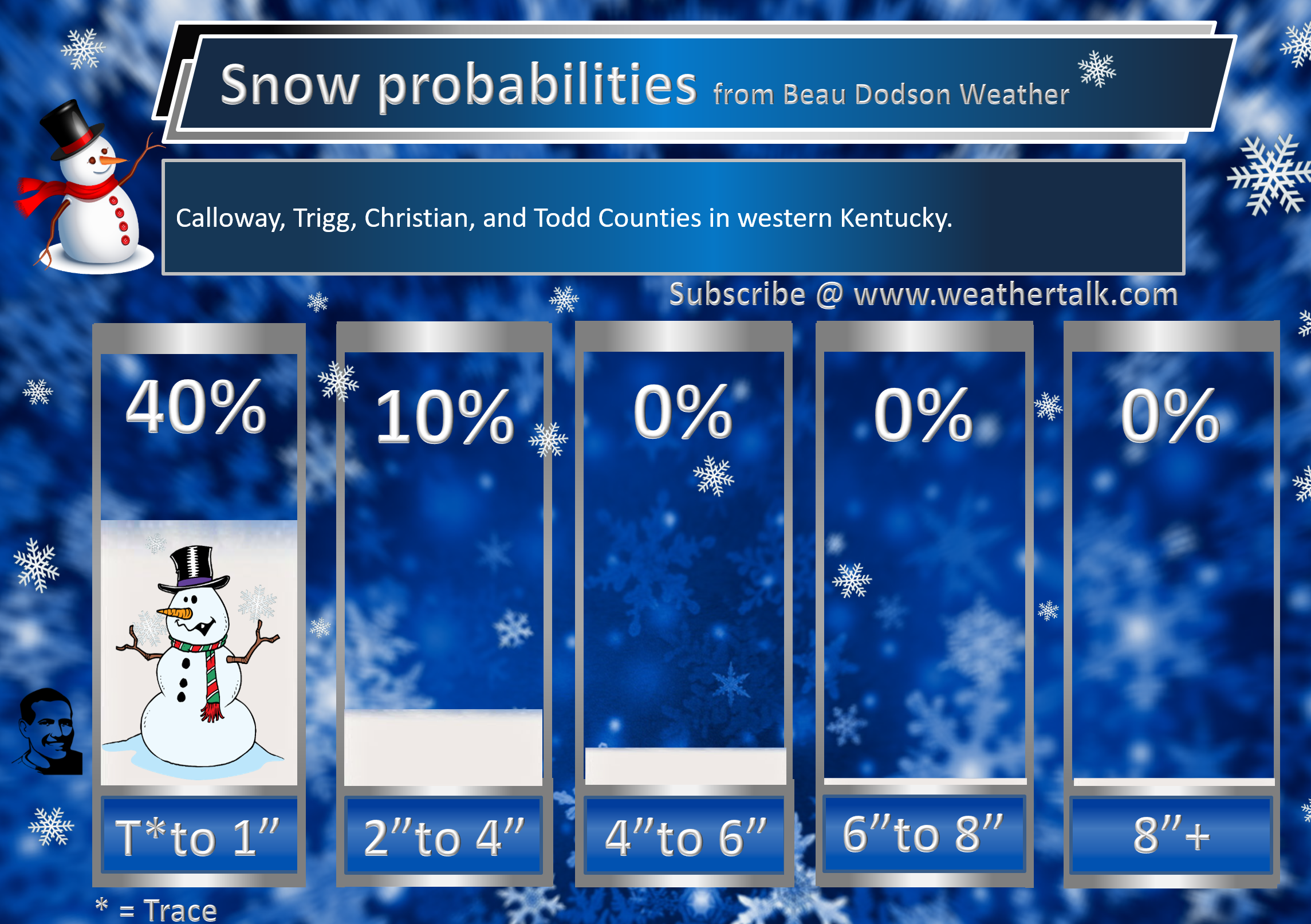
Let’s take a look at snow probabilities from NOAA.
Regional view
Click to enlarge
You can see that the focus is where I have been forecasting the greatest impact. Parts of Missouri and Illinois.
Heavy wet snow can bring down power lines. Northern parts of southeast Missouri and the northern half of southern Illinois will need to monitor this part of the forecast.
The heaviest snow should be across parts of eastern Missouri into northern parts of southern Illinois (central Illinois, as well).
You are looking at NOAA’s current snow totals forecast.
See my forecast numbers further down in this blog update.
Northwest view
Click to enlarge
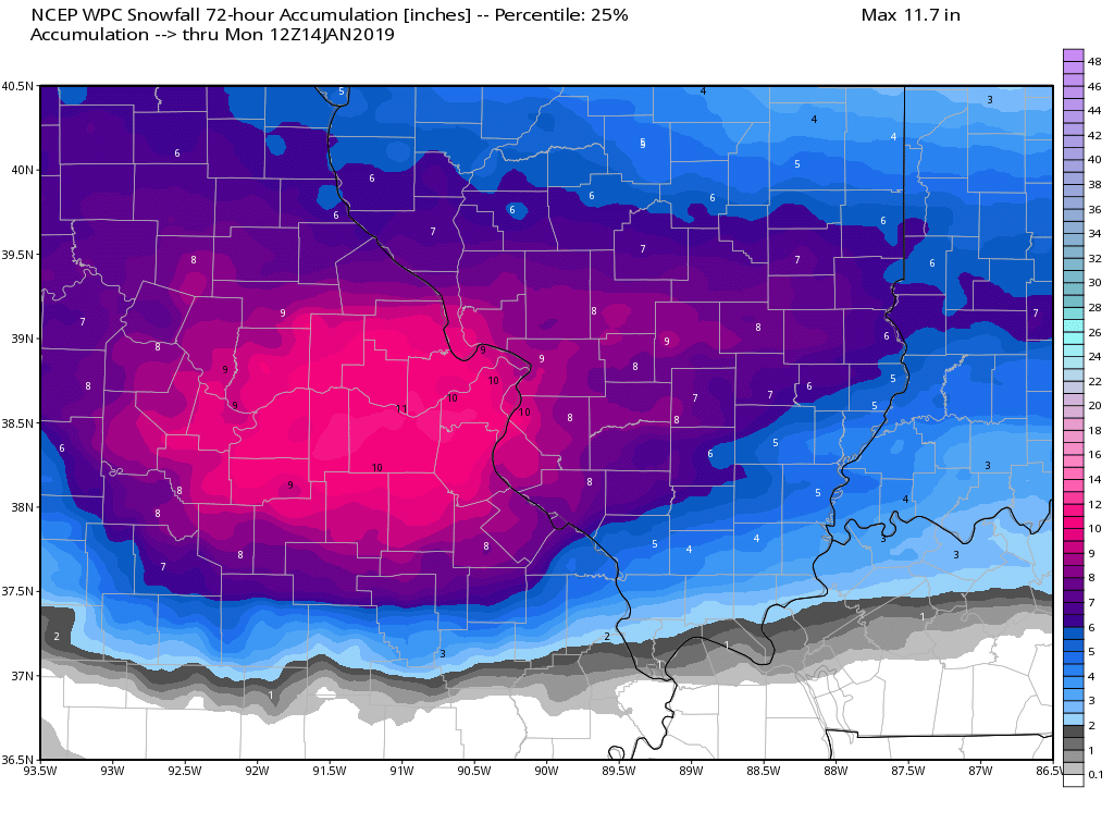
Southeast view
Click to enlarge
Subscribers, do you need a forecast for an outdoor event?

Did you know that you can find me on Twitter?


We offer interactive local city live radars and regional radars.
If a radar does not update then try another one. If a radar does not appear to be refreshing then hit Ctrl F5 on your keyboard.
You may also try restarting your browser. The local city view radars also have clickable warnings.
During the winter months, you can track snow and ice by clicking the winterize button on the local city view interactive radars.

Questions? Broken links? Other questions?
You may email me at beaudodson@usawx.com

The National Weather Service defines a severe thunderstorm as one that produces quarter size hail or larger, 58 mph winds or greater, and/or a tornado.
Today through next Thursday: Severe weather is not anticipated.
Interactive live weather radar page. Choose the city nearest your location. If one of the cities does not work then try a nearby one. Click here.
National map of weather watches and warnings. Click here.
Storm Prediction Center. Click here.
Weather Prediction Center. Click here.

Live lightning data: Click here.

Interactive GOES R satellite. Track clouds. Click here.

Here are the latest local river stage forecast numbers Click Here.
Here are the latest lake stage forecast numbers for Kentucky Lake and Lake Barkley Click Here.

- Tracking a winter storm (for some)
- Rain for some. Snow for others.
- Heavy wet snow in some areas could bring down power lines and tree branches.
Winter Storm Forecast
8 AM
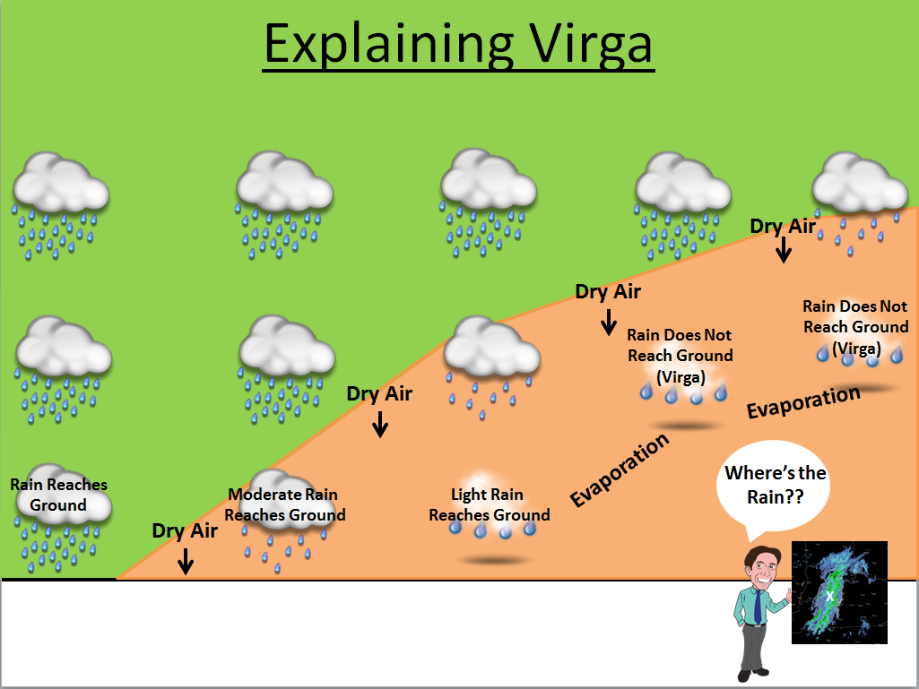
We already have a wintry mix entering southeast Missouri. Keep in mind, there is some dry air aloft and some of this may not be reaching the ground. We call that virga.
This can apply to rain or snow.
Some of the precipitation is already reaching the ground in southeast Missouri. We will have to monitor areas to the east where the air is a bit drier.
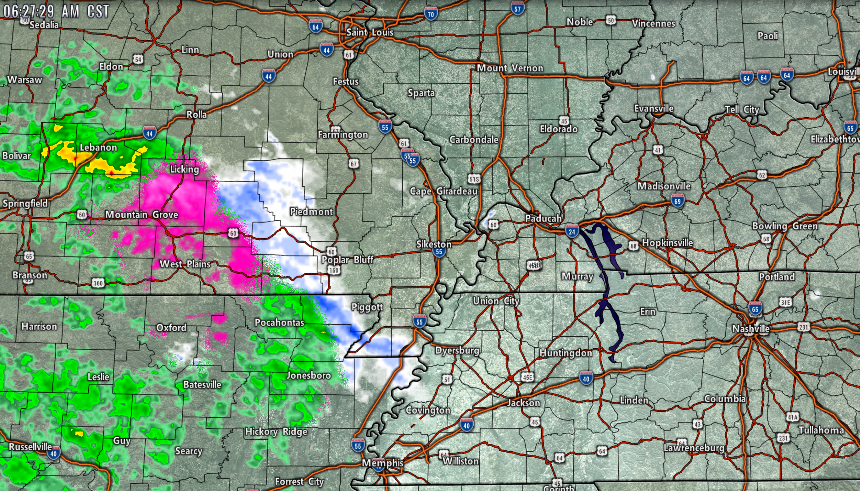
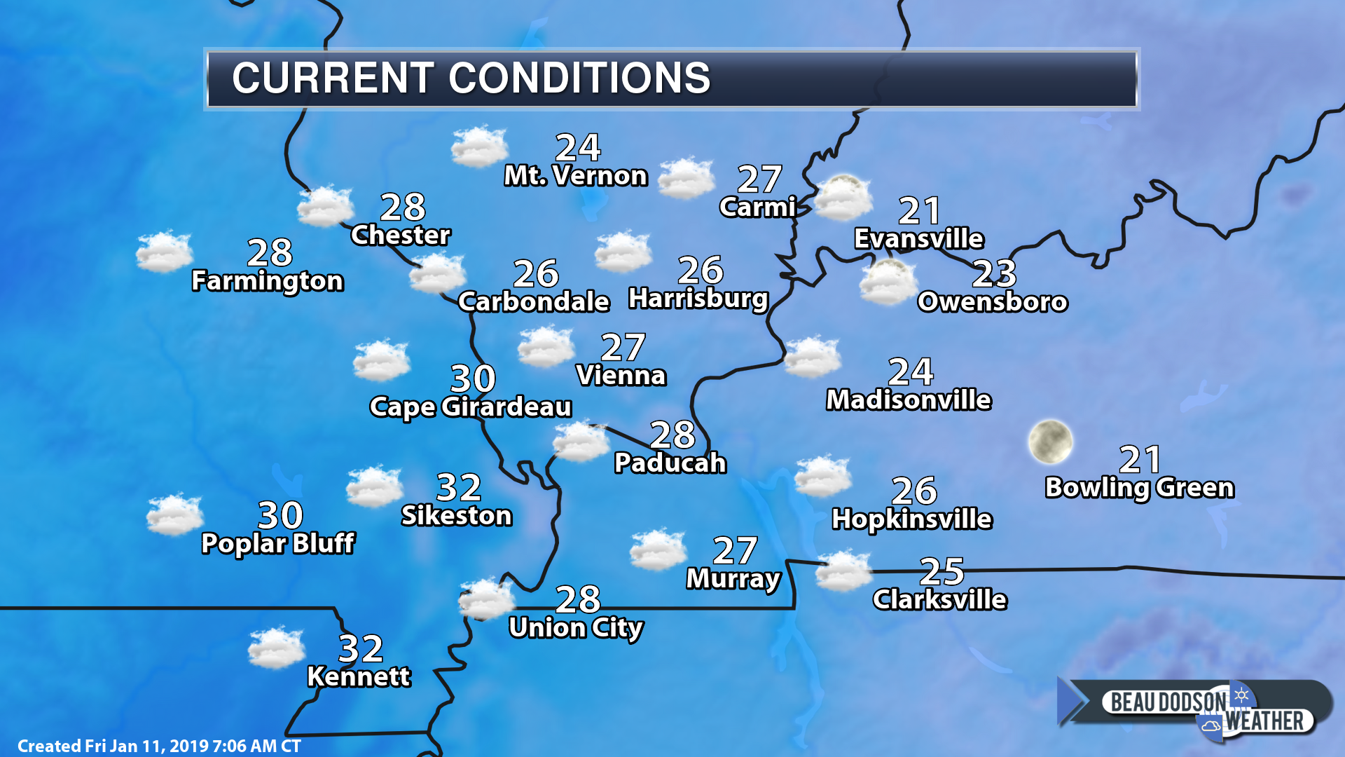
Here was the 6 AM radar view (see live radar link below)
I am reaching reports that some of this is already reaching the ground.
Radars (local city view radars and more).
Click winterize on the local city-view ones. That turns on precip type.
http://weatherobservatory.com/radar_grearth1.htm
Here is that winterize button (click it on your local city-view radars)
This initial band will push eastward over the morning hours and likely weaken. It likely will not reach everyone in my forecast area. T
Roads are cold. Any wintry mix on radars would be a concern.
Additional precipitation will arrive this afternoon into tonight. This will be the heavier band.
You will see precipitation expand on radar and become heavier.
Light precipitation totals are anticipated over the morning and early afternoon hours.
Precipitation will strengthen this afternoon and evening.
Here are the NAM 3K model temperature forecast numbers. This takes us into Saturday.
Notice how temperatures rise late tonight? That occurs as a warm push of air moves in from the south.
Marginal temperatures for wintry precip in some of my forecast counties.
Again, keep in mind, what does fall in many areas will melt away late tonight and tomorrow morning.
Some of you may go to bed with snow on the ground and wake up with nothing.
The exception will likely be the northern half of southeast Missouri and the northern half of southern Illinois. Heavier snow accumulations in those areas would mean snow would remain on the ground longer.
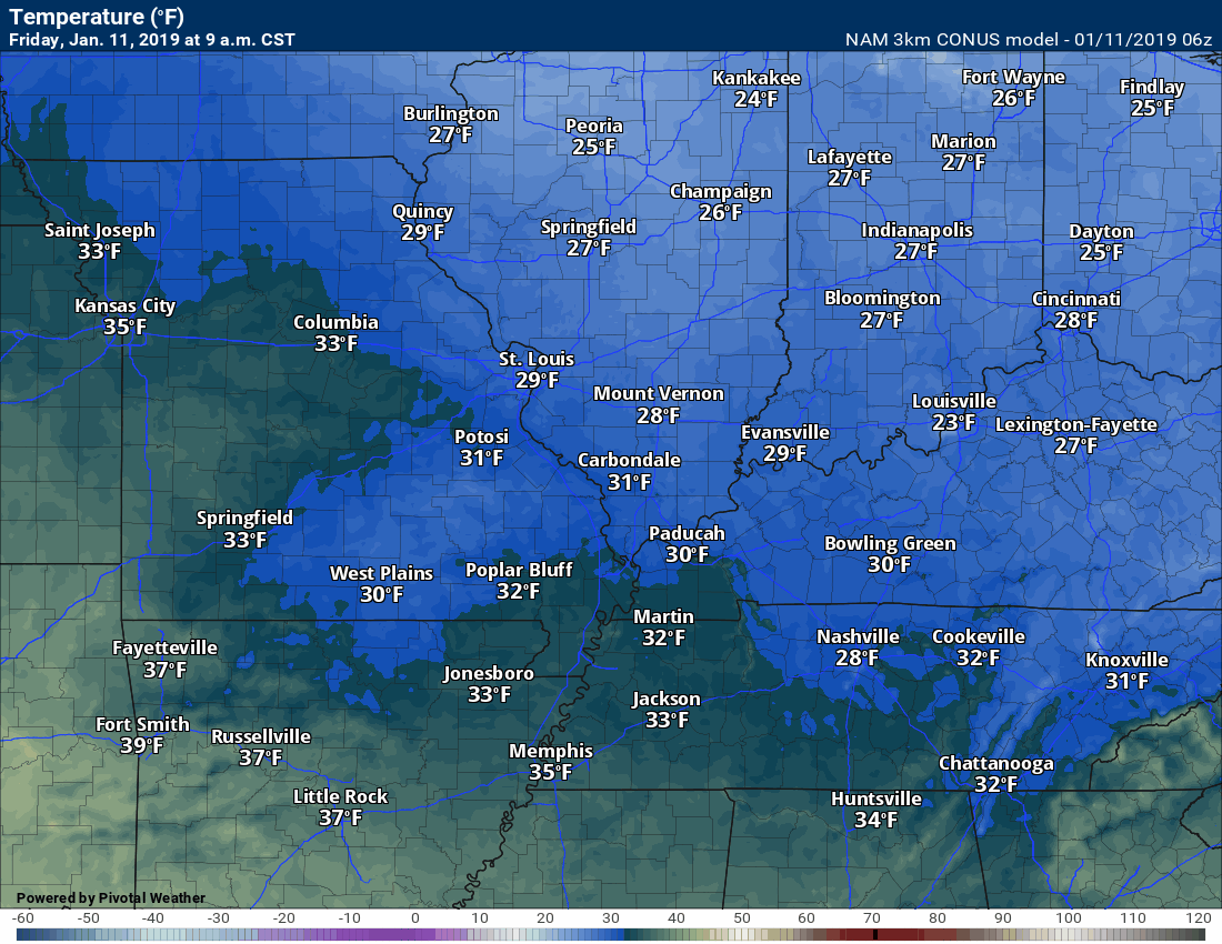
Here was the 7 AM temperature map. You can get a feel for where we are starting out the day.
Roads are cold. There could be slick spots where precipitation falls.
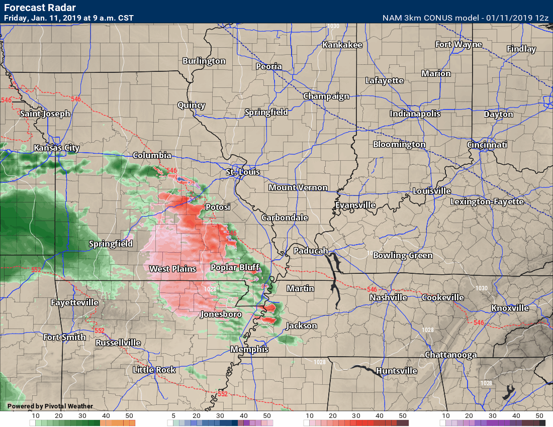
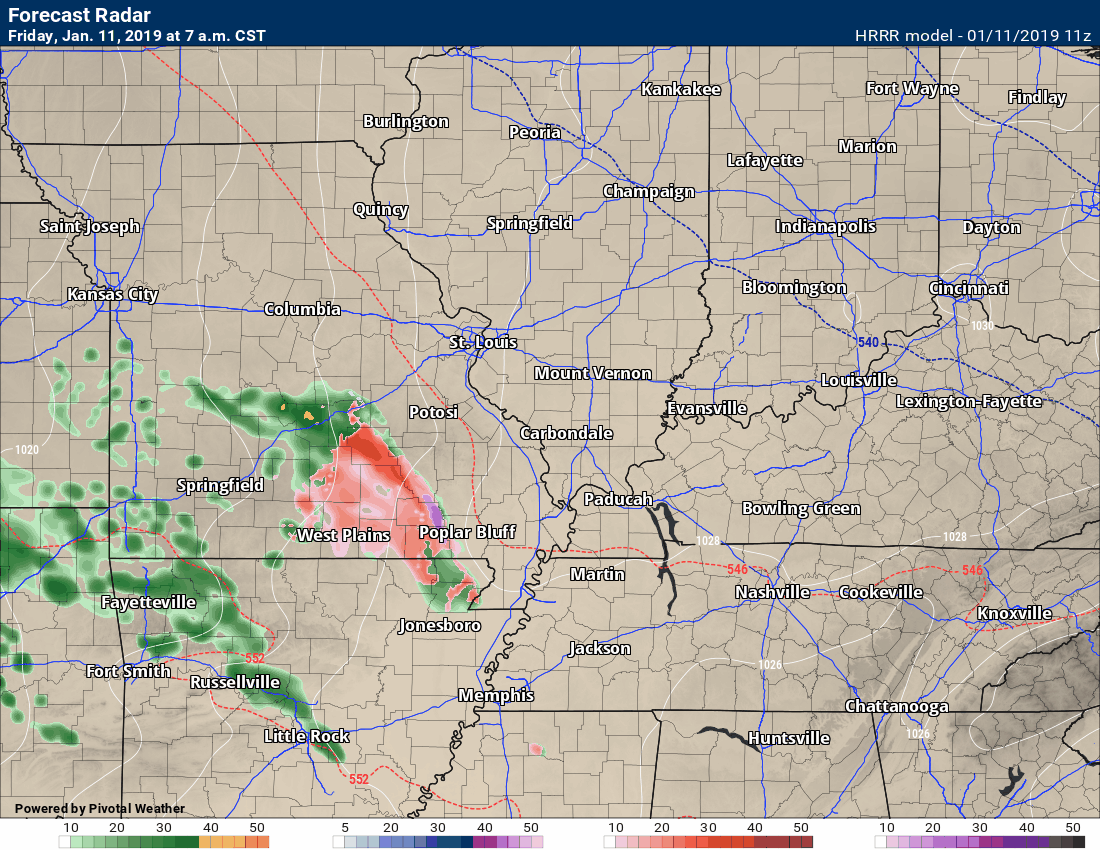
Future-cast radar from the Hrrr model guidance. Again, some of this early on could be virga. Keep that in mind, as well.
You can see precipitation does expand and become heavier as we move through this afternoon and tonight.
Also, notice the precipitation shuts down across parts of northern Arkansas into southeast Missouri tonight?
That is the dry slot. The dry slot in storms systems will shut precipitation down.
That dry slot will work its way north and east into tomorrow morning. Some of you may not have much in the way of precipitation by late tonight into Saturday morning.
Green is rain. Blue is snow. Pink/purple/red would be a wintry mix.
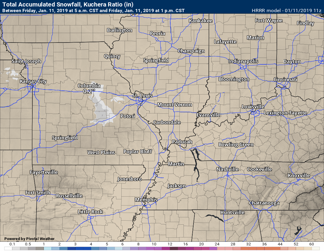
Here are the Hrrr model’s snow totals. Some of this will melt away fairly quickly tonight and tomorrow. Thus, the period of snow on the ground will be brief for many.
Time-stamp upper left.
Here is the NAM 3K model’s idea of how this all unfolds.
Another model.
Future-cast radar
Green is rain. Blue is snow. Pink/purple/red would be a wintry mix.
Here is that dry slot by tomorrow morning. This shuts down precipitation.
You can see additional precipitation back to the west.
Also, note that not all areas are dry tomorrow morning. The precipitation continues over our northern counties.
Some of you will continue to have precipitation for most of the day (Saturday). That would most likely be northern parts of southeast Missouri and northern parts of southern Illinois. Northwest Kentucky for a while, as well.
Here is the NAM’s snow depth forecast. Keep in mind, some of this will quickly melt late tonight into tomorrow morning as temperatures rise.
Areas will little accumulation will likely see their snow melt early-on in the event.
Wildcards
Keep in mind, some of this will melt when temperatures rise above freezing tonight into tomorrow morning.
You may have some snow accumulation for a period of time before it melts.
Snow may remain on the ground in areas that receive three or more inches.


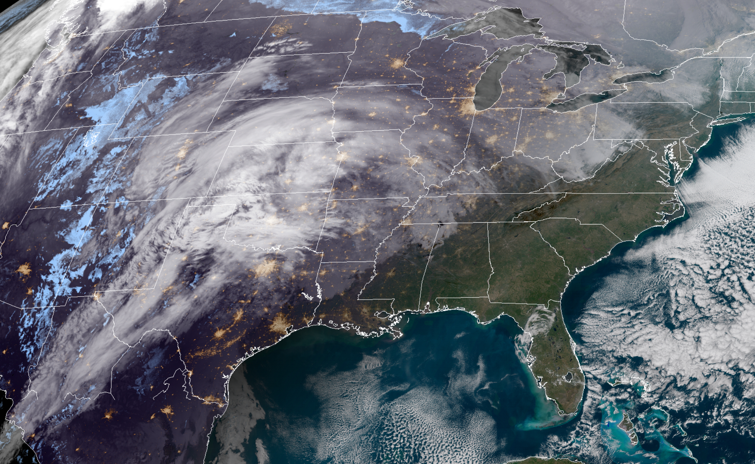
Live satellite views. Click here
Click to enlarge
This is the morning visible satellite.
You can see the feed of moisture into our region from the south and southwest.
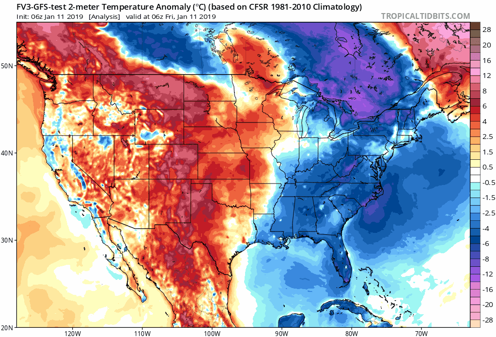
Temperature Anomalies
Let’s look at the temperature anomaly forecast map from the GFS model guidance.
I will keep showing you this graphic animation over the coming weeks.
Red colors indicate above normal temperatures. Blue colors represent below normal temperatures.
The time-stamp is located in the upper left portion of the map animation.
Click to enlarge. Date stamp upper left.
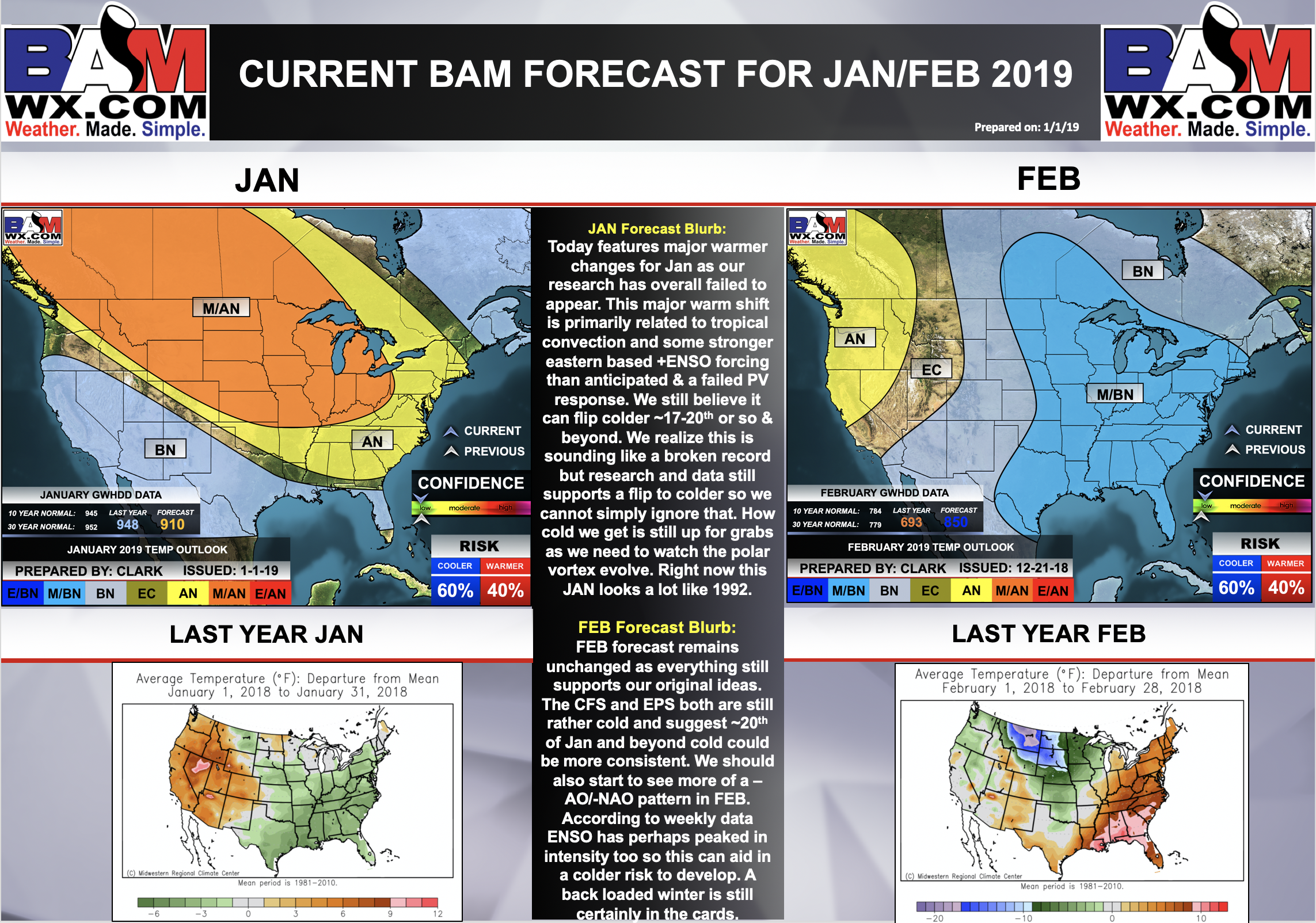
January and February Outlook Update
Click to enlarge and read this graphic.
This is the updated January and February outlooks.
There has been a dramatic shift in the January outlook. Instead of below normal temperatures (when all averaged out) the long-range team has moved towards warmer than normal.
That does not mean we won’t have cold weather.
I am monitoring the end of January into February for the potential of colder weather.
For now, we are going to remain above normal.
Perhaps this will end up a back-loaded winter.
Time will tell.
![]()
Bonus VIDEO UPDATES
These are bonus videos and maps for subscribers. I bring these to you from the BAMwx team. I pay them to help with videos.
The Ohio and Missouri Valley videos cover most of our area. They do not have a specific Tennessee Valley forecast but may add one in the future.
The long-range video is technical. Over time, you can learn a lot about meteorology from the long range video. Just keep in mind, it is a bit more technical.
NOTE: THESE ARE USUALLY NOT UPDATED ON SATURDAY OR SUNDAY.


Missouri Valley
![]()

I bring these to you from the BAMwx team. They are excellent long-range forecasters.
Remember, long-range outlooks are always going to be a lower confidence level than short-term forecasts. It is not an exact science. There are many variables that determine the eventual outcome of a long-range forecast.

Normal high temperatures for this time of the year are around 43 degrees.
Normal low temperatures for this time of the year are around 26 degrees.
Normal precipitation during this time period ranges from 0.60″ to 0.80″
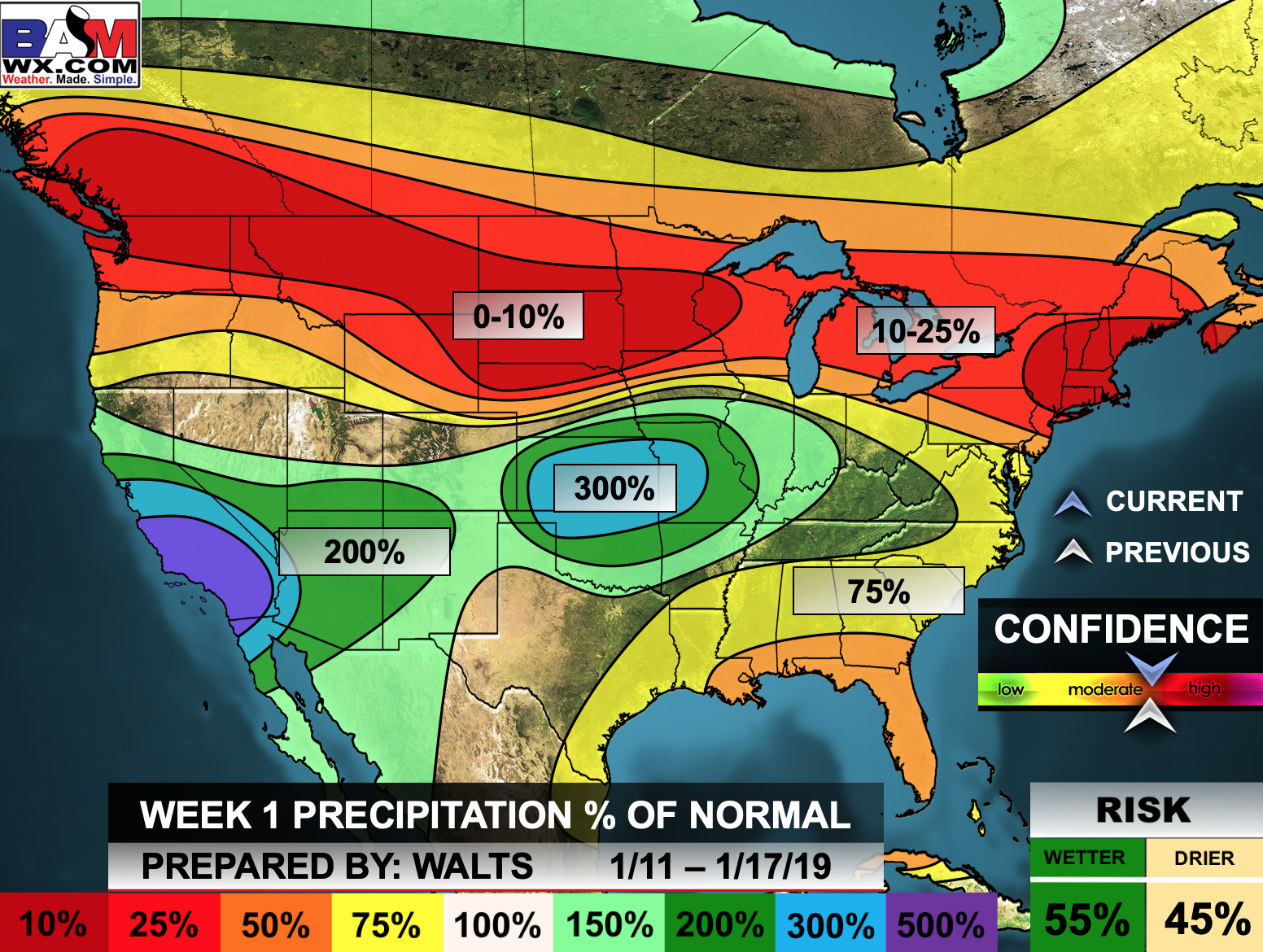
This outlook covers January 11th through the 17th
Click images to enlarge them.

The precipitation forecast is PERCENT OF NORMAL. For example, if your normal rainfall is 1.00″ and the graphic shows 10%, then that would mean 0.10″ of rain is anticipated.

Normal high temperatures for this time of the year are around 42 degrees
Normal low temperatures for this time of the year are around 25 degrees
Normal precipitation during this time period ranges from 0.60″ to 0.80″
This outlook covers January 17th through January 23rd
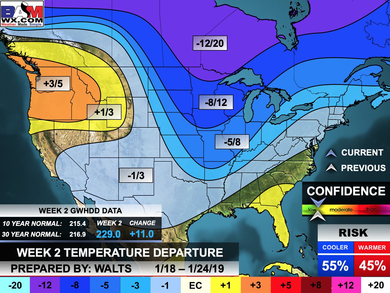
The precipitation forecast is PERCENT OF NORMAL. For example, if your normal rainfall is 1.00″ and the graphic shows 10%, then that would mean 0.10″ of rain is anticipated.
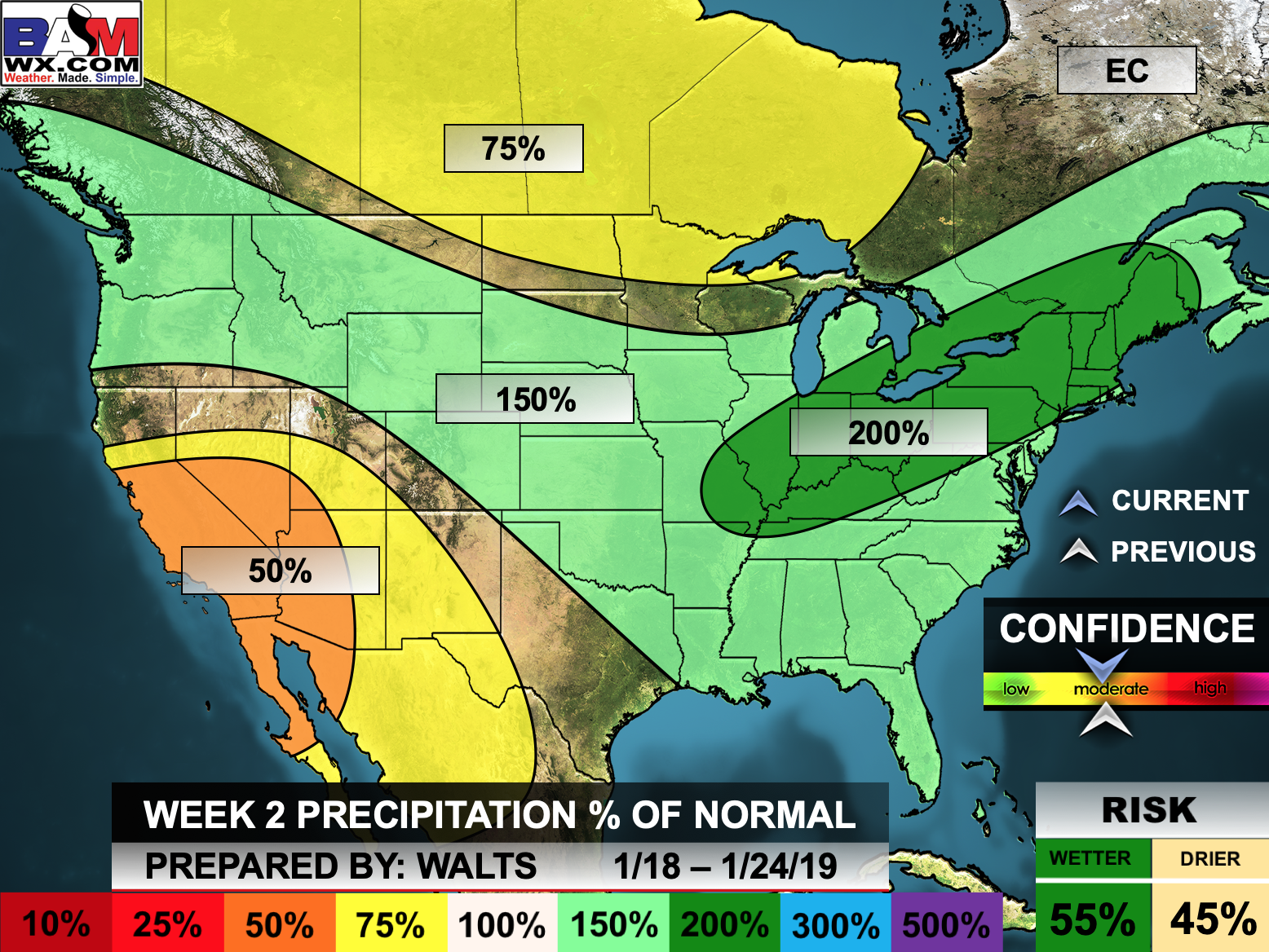

Outlook definitions
EC = Equal chances of above or below normal
BN= Below normal
M/BN = Much below normal
AN = Above normal
M/AN = Much above normal
E/AN = Extremely above normal
Normal high temperatures for this time of the year are around 42 degrees
Normal low temperatures for this time of the year are around 24 degrees
Normal precipitation during this time period ranges from 1.40″ to 1.80″
This outlook covers January 25th and February 2nd
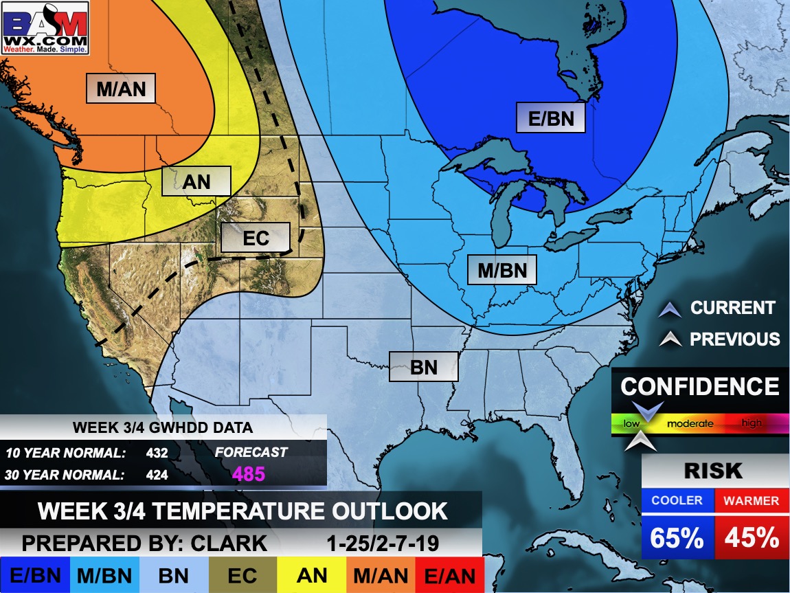
The precipitation forecast is PERCENT OF NORMAL. For example, if your normal rainfall is 1.00″ and the graphic shows 10%, then that would mean 0.10″ of rain is anticipated.

![]()

The winter update has been posted.
I always tell people to read this
http://johndee.com/seasonalfcst/soapbox.htm
Well, the towel is being thrown in on major cold over the next couple of weeks.
We will see how everything unfolds.
The updated January and February temperature outlook.
Click to enlarge the graphic to read the analysis.
This is a major adjustment from previous forecasts.

![]()
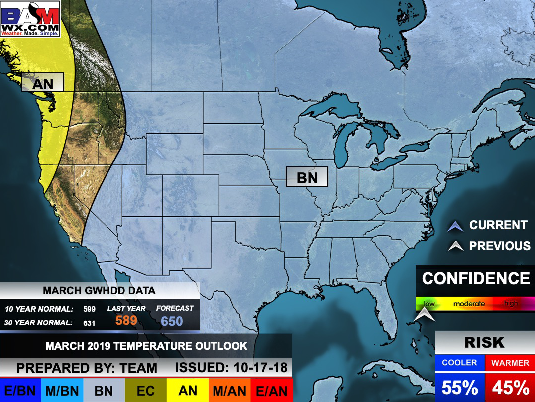
March Temperature Outlook
![]()

A new weather podcast is now available! Weather Geeks (which you might remember is on The Weather Channel each Sunday)
To learn more visit their website. Click here.
![]()

WeatherBrains Episode 677
Tonight’s show focuses on amateur radio and how it relates to meteorology. Joining us are 3 top-notch amateur radio operators tonight. First up is Jay Farlow (W9LW), who has been a ham since the early 1970s. He’s also been a volunteer EMT and firefighter and member of a disaster medical assistance team. Also joining us is Rob Macedo (KD1CY). Rob has served as the ARES SKYWARN Coordinator for NWS Boston/Norton (formerly Taunton) since 1996 and has been an avid SKYWARN Spotter since he got his Ham license in 1988. Last but not least, Jeff Stapel of SKYWARN (W8SWX) joins this week’s show from Michigan and shares his valuable insight.
Tonight’s Guest Panelist is Scott Martin from The Weather Factory.
Other discussions in this weekly podcast include topics like:
2019 AMS Annual Meeting
Discussing the government shutdown’s effect on weather enterprise
Nov. 10th, 2002 outbreak and how amateur radio operators assisted in storm spotting
State of Connecticut has record number of tornadoes in 2018
The Astronomy Report from Tony Rice
and more!
Link to their website https://weatherbrains.com/
Previous episodes can be viewed by clicking here.
We offer interactive local city live radars and regional radars. If a radar does not update then try another one. If a radar does not appear to be refreshing then hit Ctrl F5. You may also try restarting your browser.
The local city view radars also have clickable warnings.
During the winter months, you can track snow and ice by clicking the winterize button on the local city view interactive radars.
You may email me at beaudodson@usawx.com
Find me on Facebook!

Find me on Twitter!

Did you know that a portion of your monthly subscription helps support local charity projects?
You can learn more about those projects by visiting the Shadow Angel Foundation website and the Beau Dodson News website.

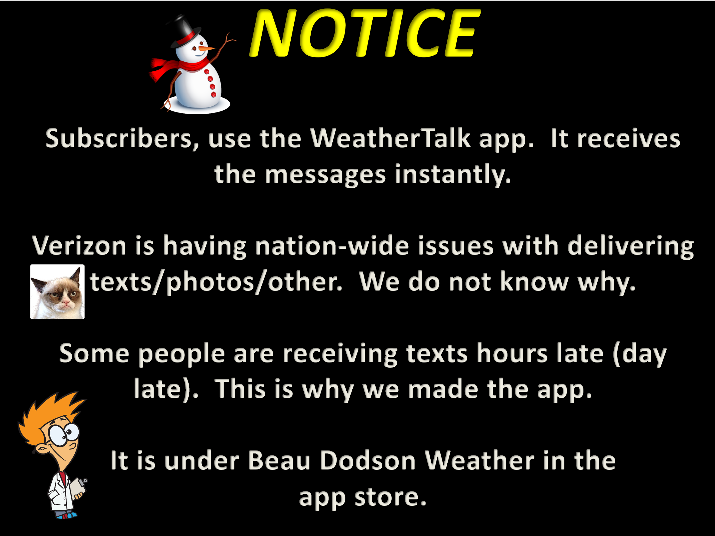
I encourage subscribers to use the app vs regular text messaging. We have found text messaging to be delayed during severe weather. The app typically will receive the messages instantly. I recommend people have three to four methods of receiving their severe weather information.
Remember, my app and text alerts are hand typed and not computer generated. You are being given personal attention during significant weather events.
