As with anything in life, nothing is free.
Normal monthly operating costs, for Weather Talk, ranges from $1500 to $2000.
Here are my monthly out of pocket expenses
.

.
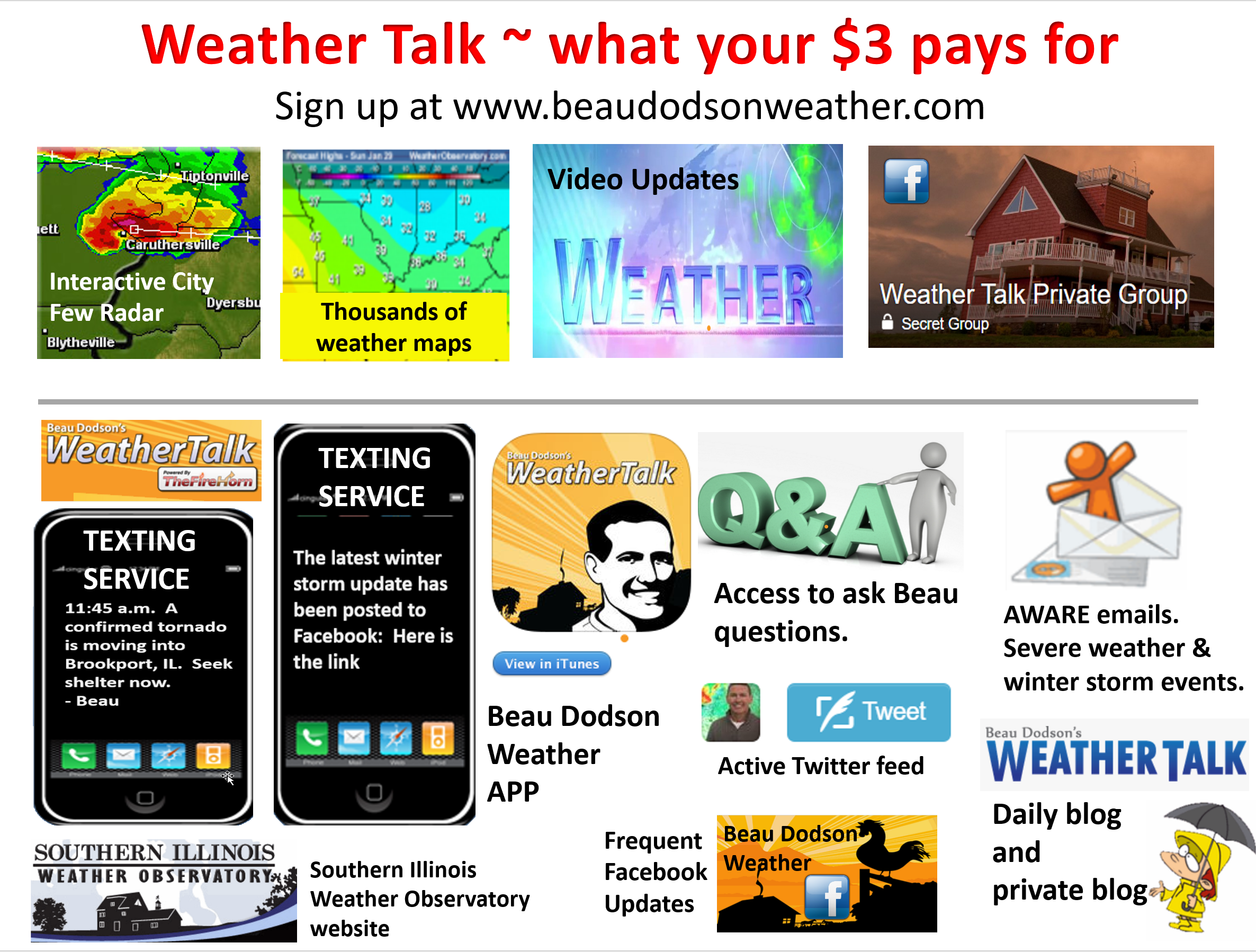
Your $3 subscription allows you access to these products
.
.
If you would like to support this data, then please subscribe. Your $3 a month helps cover the costs of the weather graphics, videos, and my time.
You may choose app/text notifications for my Facebook and blog updates. I will send you a link to the latest updates via the app/text.
You may subscribe at www.beaudodsonweather.com
Once you subscribe you can choose from four different app/text options.
.
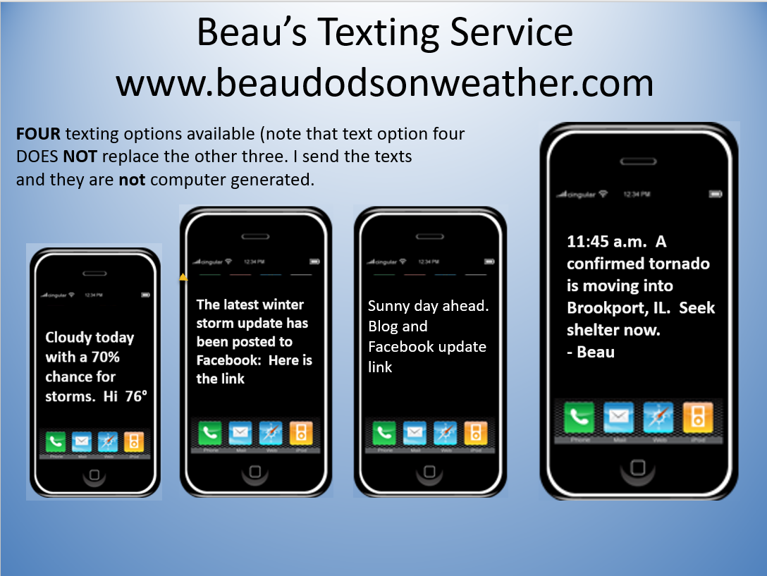
Here are the four options.
.
January 11, 2018
The daily outlook can be found at the bottom of this post.
Forecast
Interactive Weather Radar Page. Choose the city nearest your location: Click this link
There will be the free blog site located here Weather Talk Free Blog
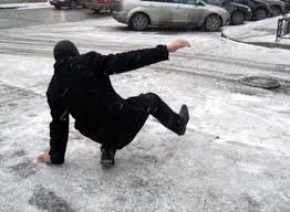
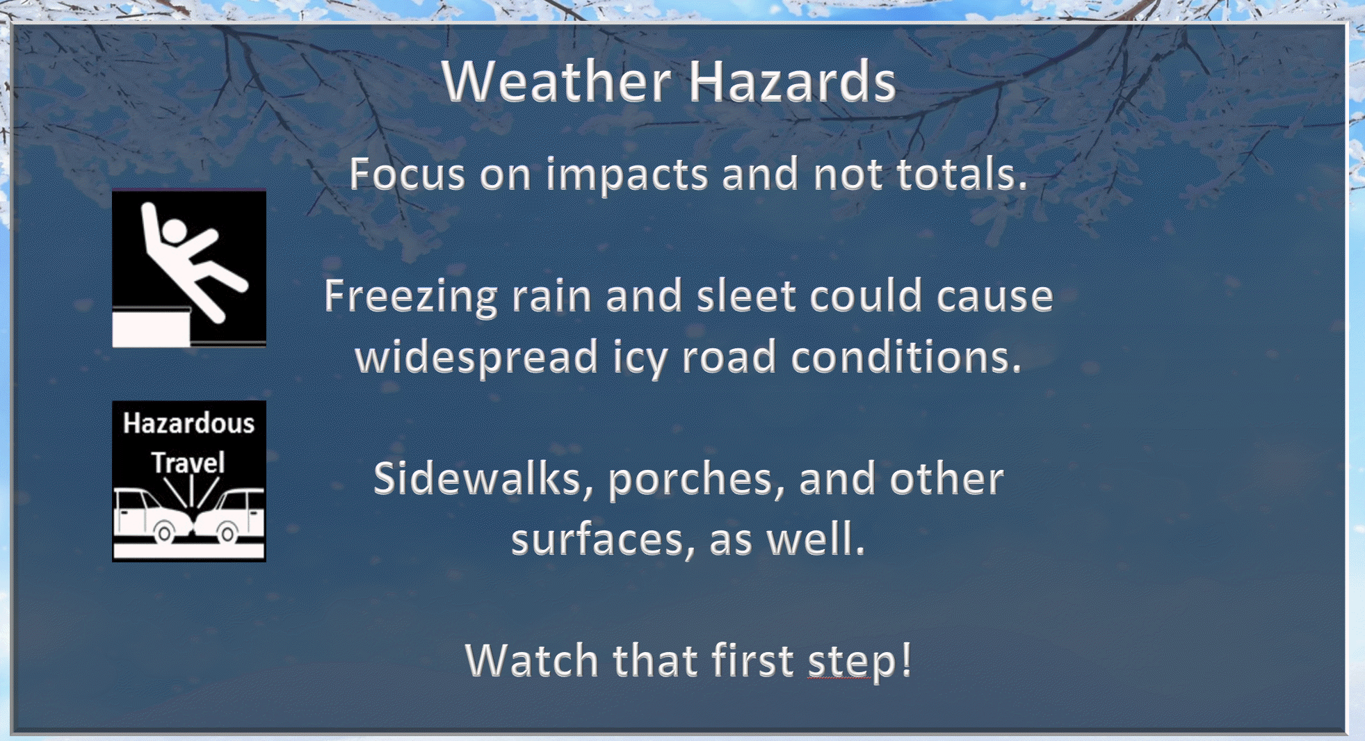
Watch that first step late tonight and tomorrow. Ice is likely.
.
 .
.
.
.
Today
Unseasonably mild today with highs reaching into the 60’s. We will have plenty of clouds. Showers will also develop ahead of a strong cold front.
No freezing rain, sleet, or ice through this afternoon. We will be on the warm side of the front.
A few thunderstorms are also possible. Severe weather is not anticipated.
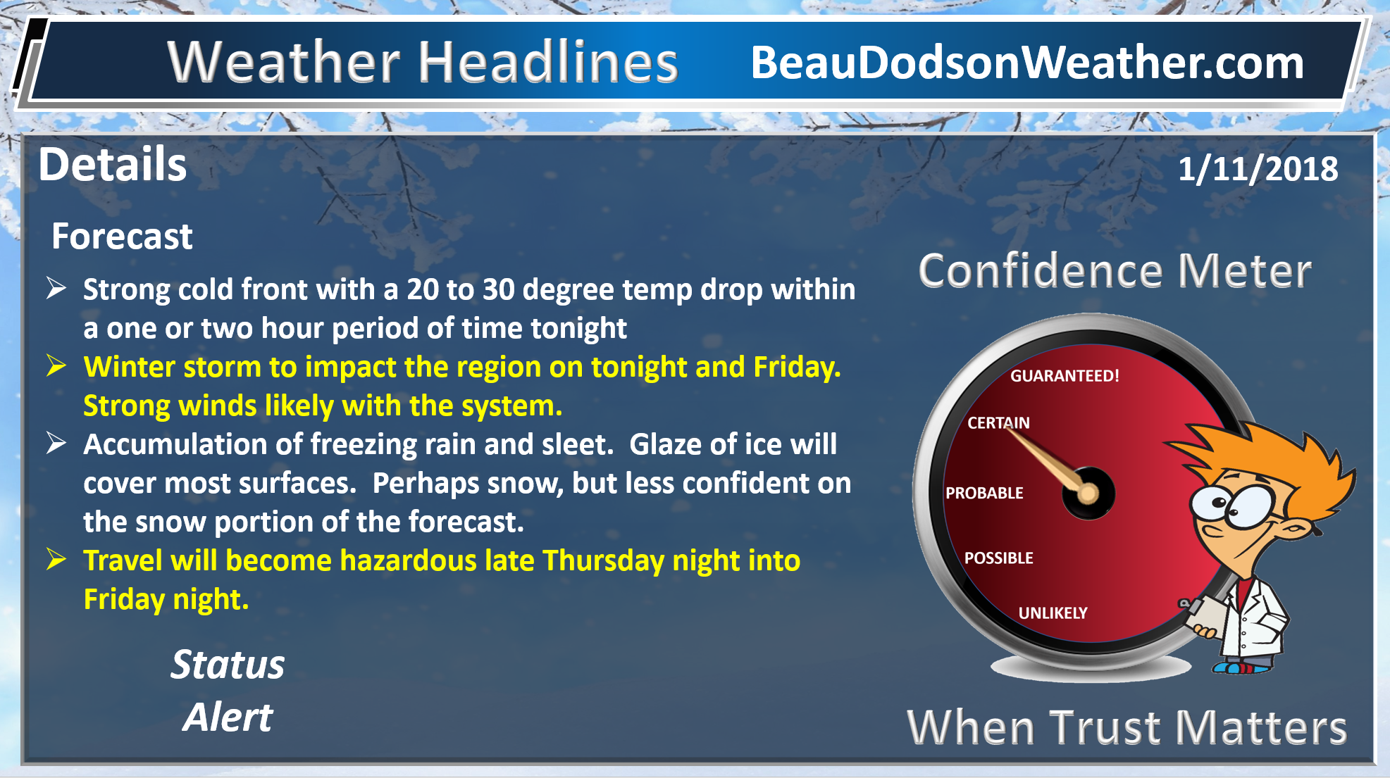
Tonight into Friday night
A powerful cold front will sweep through the region tonight. This front will drop temperatures 20 to 30 degrees within a one to two hour time-frame.
The front should reach southeast Missouri between 5 pm and 7 pm. Southern Illinois between 7 PM and 9 PM. Western Kentucky between 9 PM and 12 AM. Rough estimates.
You will know when the front arrives. Gusty winds and rapidly falling temperatures will accompany it.
The rain may be heavier right ahead of the front, as well.
Rain will change to freezing rain and sleet tonight and will last into Friday morning.
Thunderstorms are possible with the freezing rain and sleet. We will call that thunderice.
It is unclear as to whether the cold layer will become deep enough to change everything over to snow.
I did include snow in the forecast, but totals should be light.
The best chance of snow may end up over southeast Illinois and the Pennyrile area of western Kentucky.
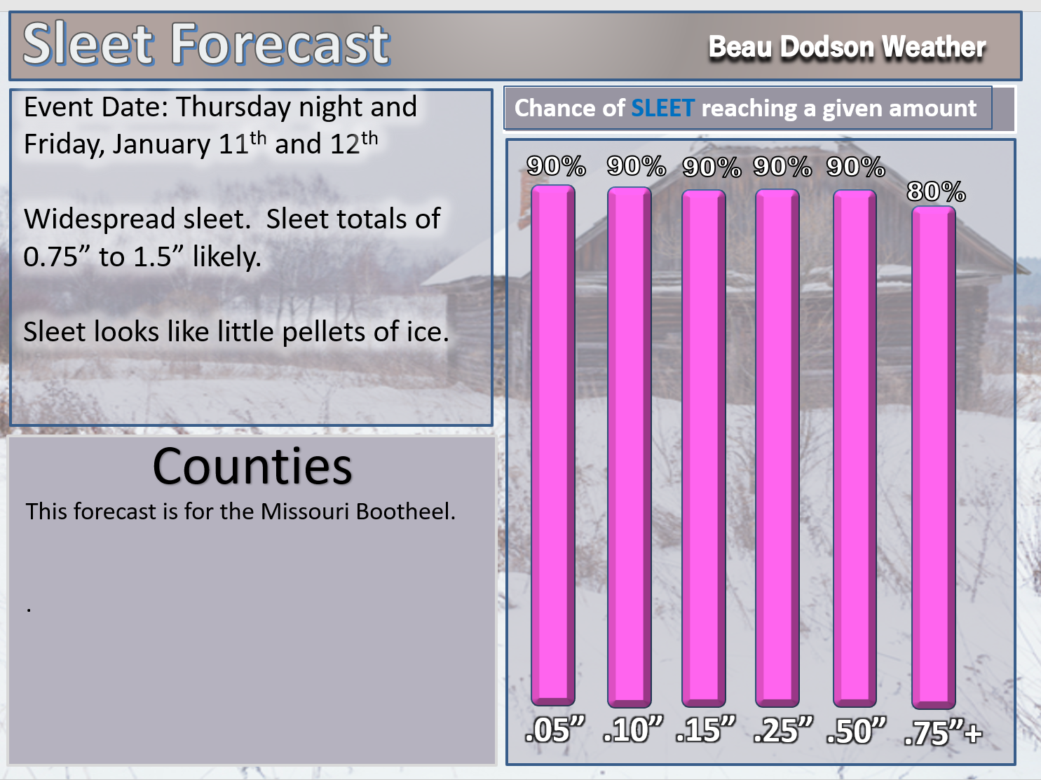
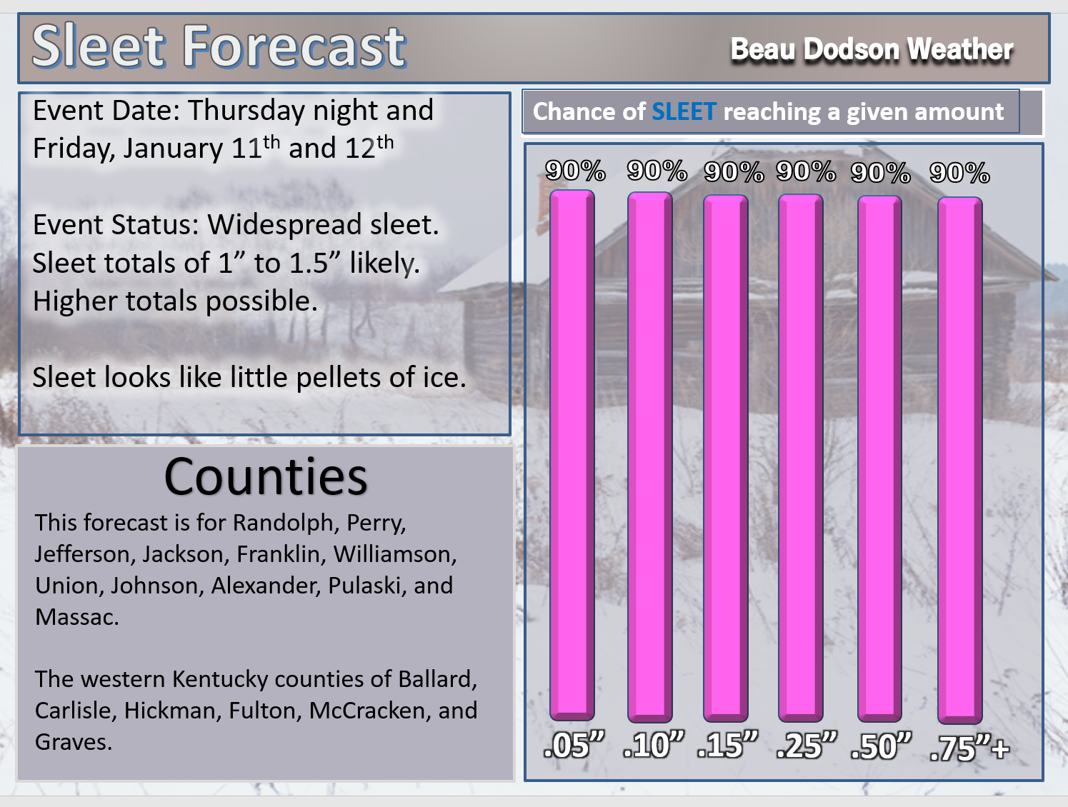
Sleet totals of one to two inches are likely. Freezing rain totals of 0.05″ to 0.25″ are possible. We will need to monitor the freezing rain to sleet transition. If the freezing rain lingers then some areas could experience tree branches breaking and short term power outages.
Roads will become icy late tonight into Friday. What falls will stick. What falls will also be around into early next week.
Bitterly cold air this weekend into early next week.
A reinforcing shot of cold air will arrive Monday and Monday night. Lows by Tuesday should drop into the single digits and perhaps below zero. Below zero readings are more likely if we have snow and ice on the ground.
A light snow event is possible Sunday and Monday. Right now it appears that a one to three inch snow event is possible. Still early for certainties.
One event would be Sunday and another along the arctic cold front on Monday. Monitor updates. Snow chances may be highest on Monday.
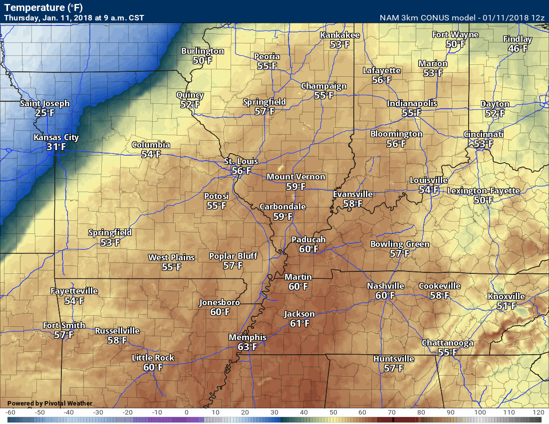
Here is the temperature forecast map into tonight. What an amazing cold front! Wow.
.
.
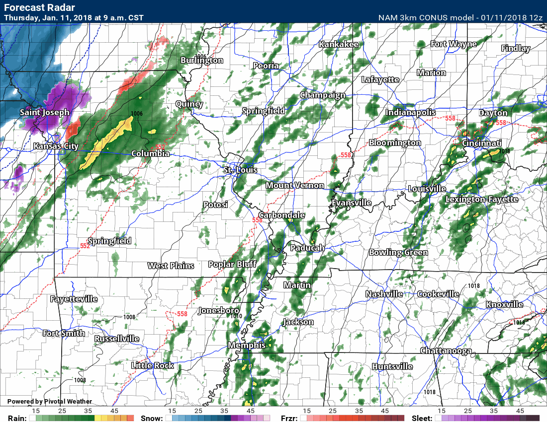
Here is the NAM 3K high resolution model guidance future-cast radar.
Green is rain. Yellow is moderate rain. Red is freezing rain. Pink and purple would be sleet. Blue is snow.
Time stamp top left of image.
.
.
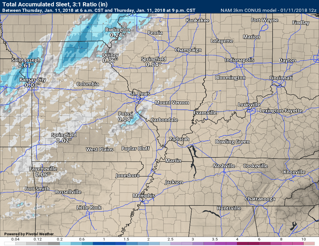
Here is the sleet total forecast (below). This is from the NAM model guidance. This gives you a rough idea. It won’t be exact.
Bottom line is there will be icy roads late tonight into Friday (and the weekend).
Most of the precipitation will occur tonight into Friday morning. Tapering off from west to east on Friday late morning and afternoon.
Sleet forecast totals
Thunderstorms are possible with sleet tonight and Friday morning.
.
.
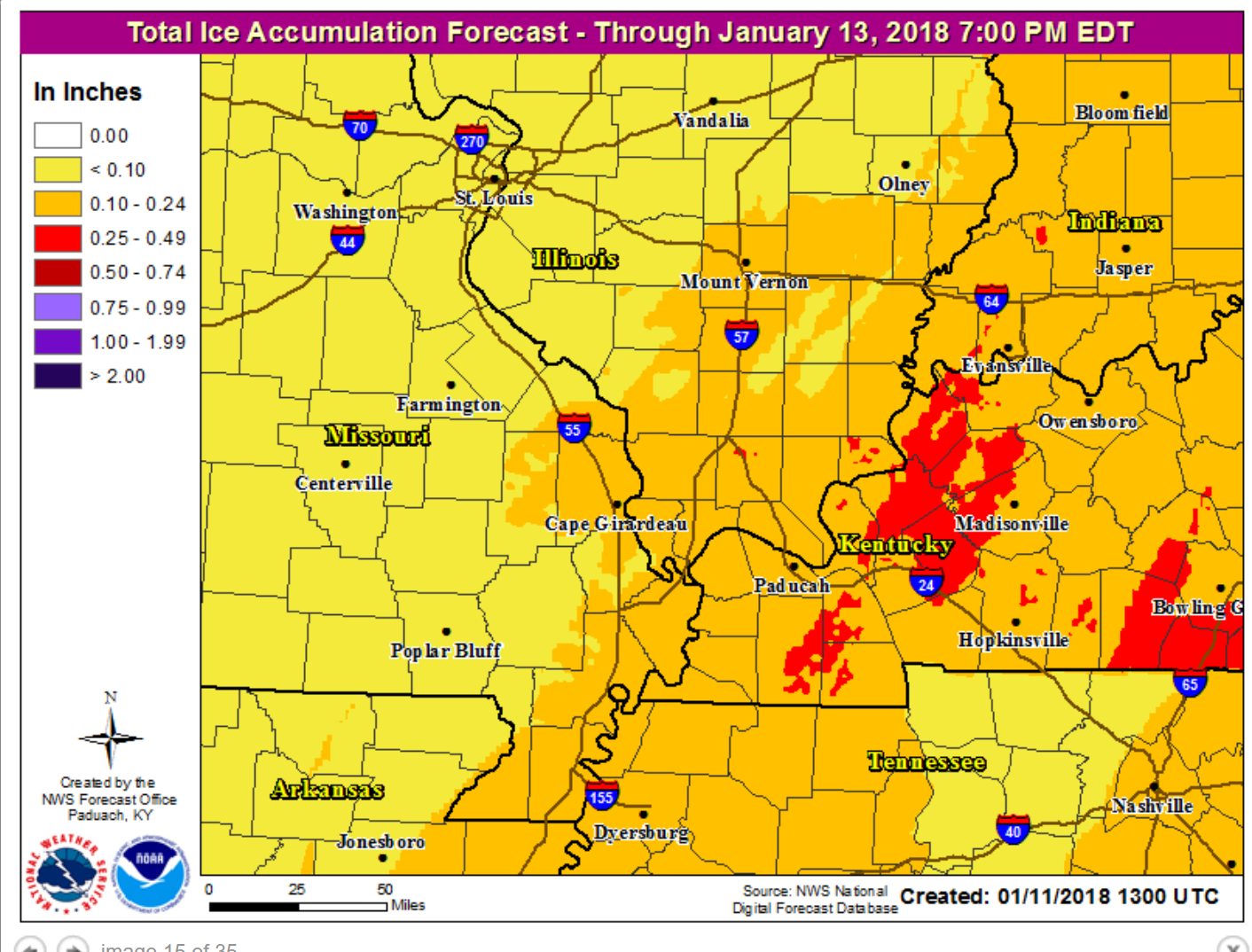
Freezing rain is also possible.
Freezing rain totals forecast. Totals will vary greatly depending on when the freezing rain changes to sleet.
.
.
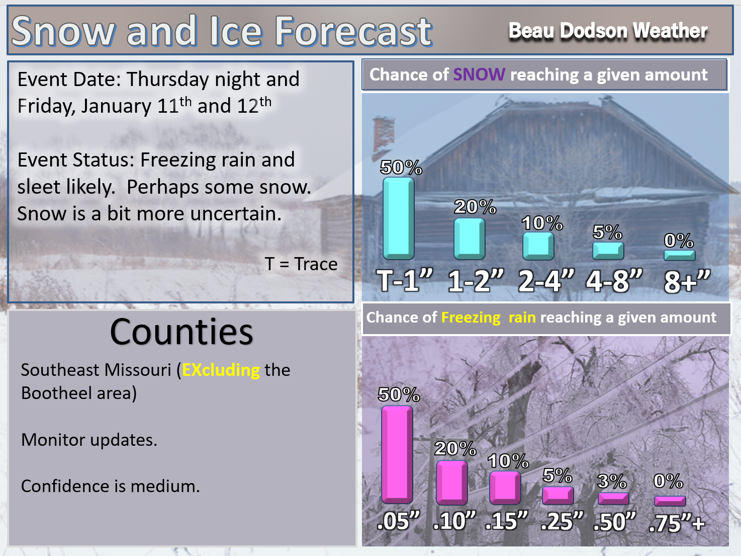
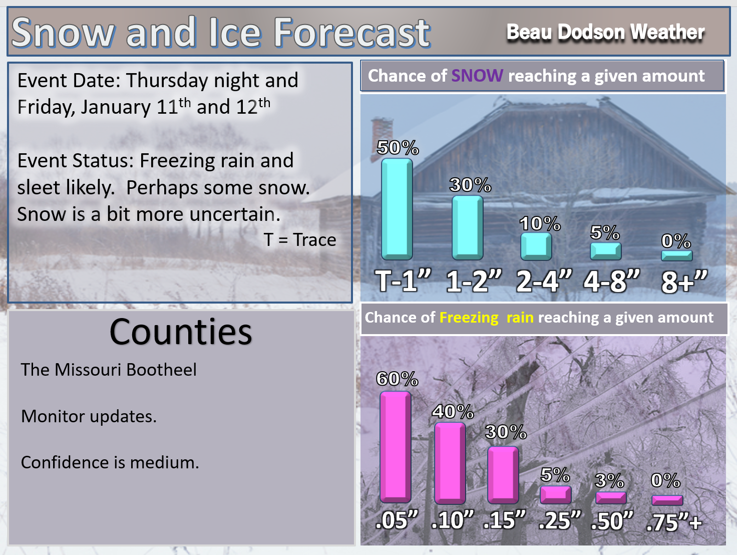
Here is the snow forecast. Confidence in snow totals remains LOW. Just not sure how much snow will fall with this system.
.
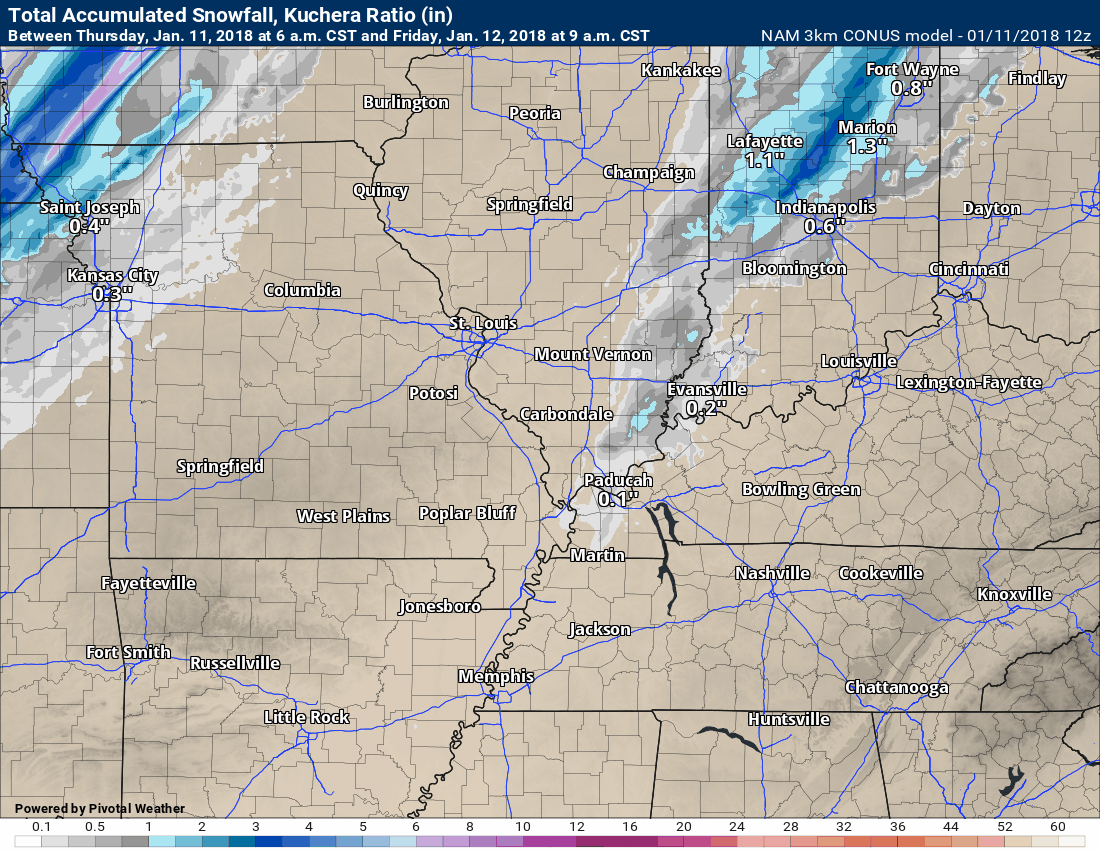
.
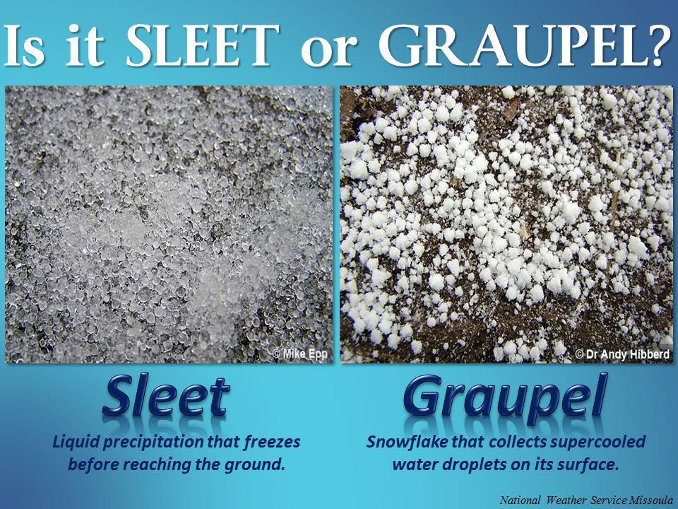
What is sleet?
.
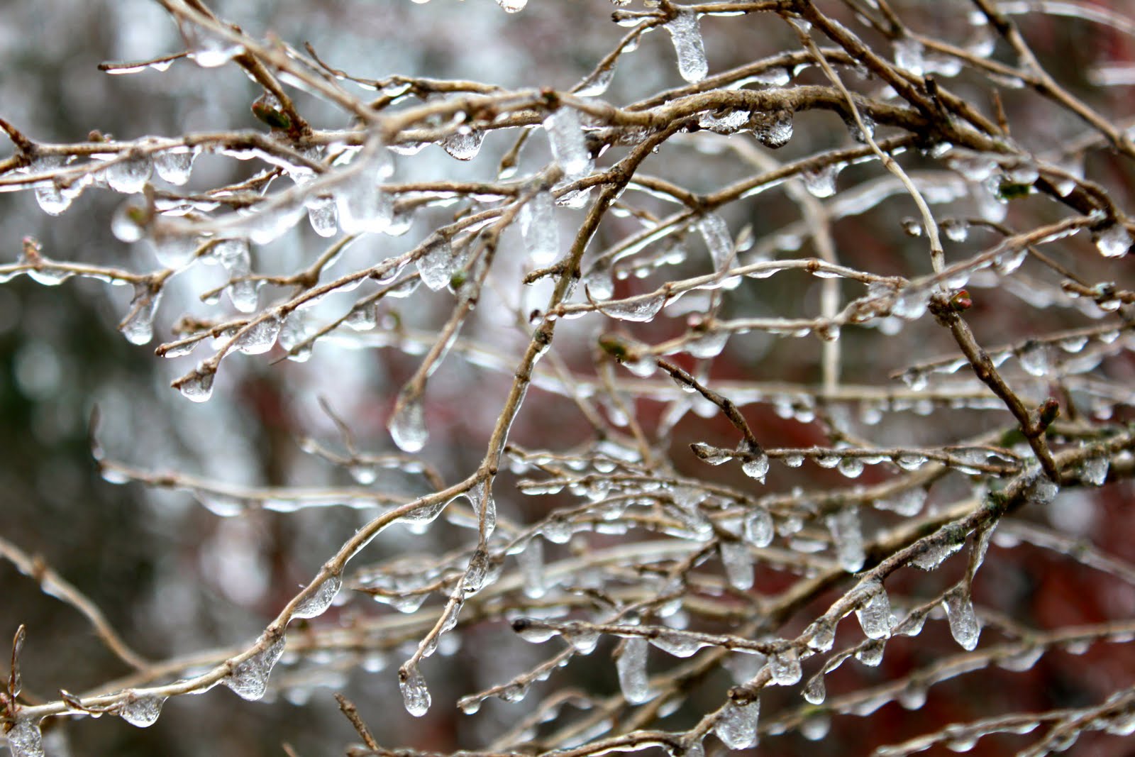
What is freezing rain?
.
.
.
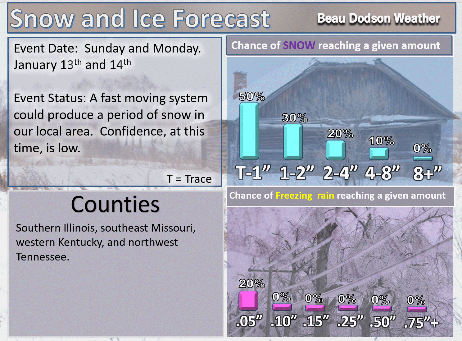
Beau’s Winter Weather Outlook
.
.
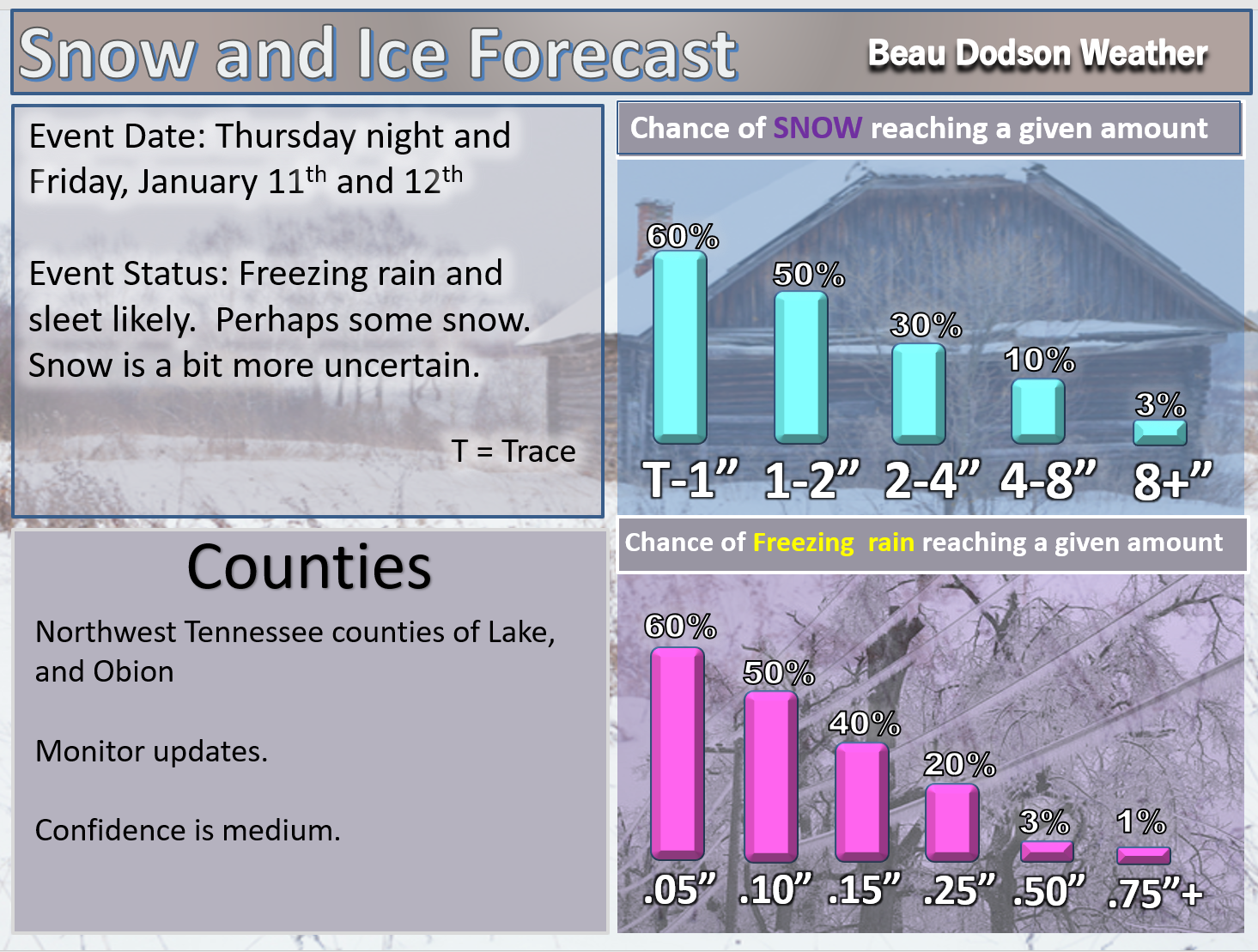
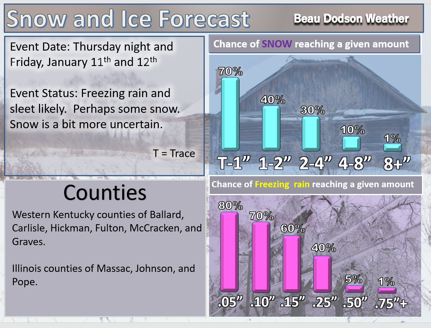
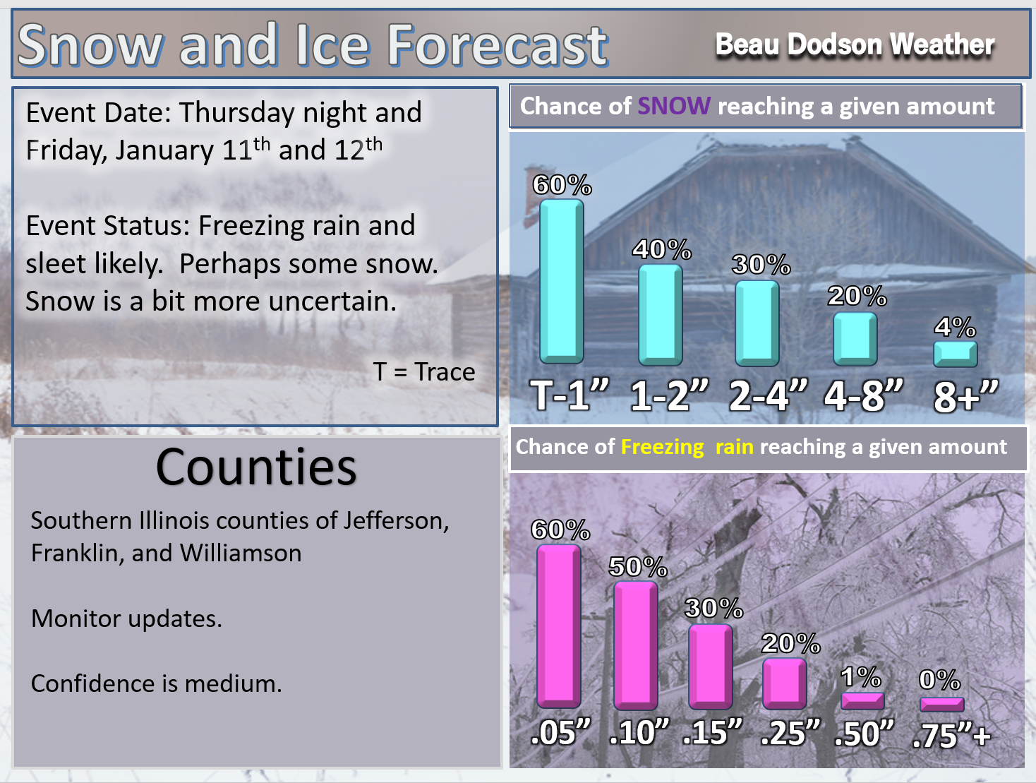
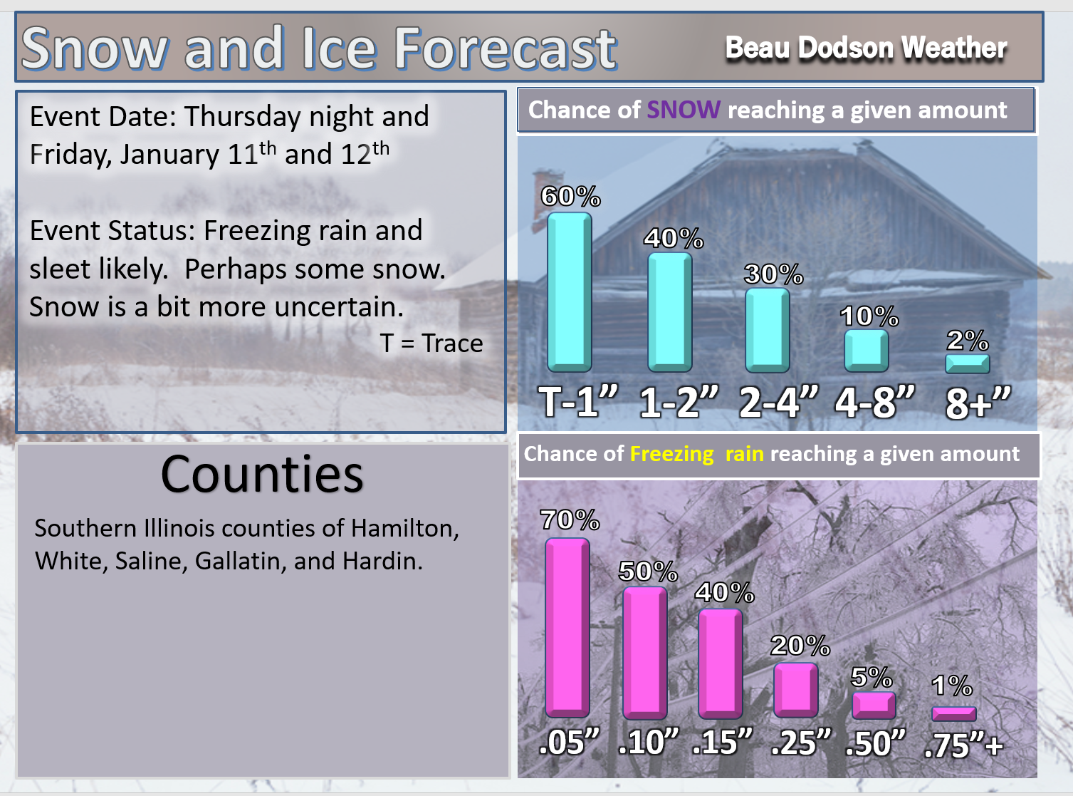
Here are my latest freezing rain, sleet, and snow probability maps.
T-1″ means a trace to one inch.
I have separated the freezing rain and snow totals from the sleet. This is likely going to be a big sleet event.
Sleet forecast
.
.

.
Freezing rain and snow.
The snow part of the forecast remains uncertain.
.


.
A fast moving system could deliver light snow to portions of the region on Sunday and Monday. It is still early to know the exact track of the system.
These numbers will need adjusting moving forward.
T-1″ means a trace to one inch.
Sometimes these type of systems overachieve. Let’s monitor trends.
.
.

.
January 11, 2018
Thursday Forecast Details
Forecast: Cloudy and windy. Mild. Scattered showers likely.
Temperatures: MO ~ 60 to 64 IL ~ 60 to 64 KY ~ 60 to 64
What is the chance of precipitation? MO ~ 60% IL ~ 60% KY ~ 60% TN ~ 60%
Coverage of precipitation: Numerous showers possible
Wind chill values: N/A
Accumulating snow or ice: No
Winds: South at 10 to 20 mph winds may switch to west and northwest once the cold front passes.
What impacts are anticipated from the weather? Wet roadways. Lightning.
My confidence in the forecast verifying: High
Is severe weather expected? No
The NWS defines severe weather as 58 mph wind or great, 1″ hail or larger, and/or tornadoes
Should I cancel my outdoor plans? Have a plan B in case it rains
.
Thursday night Forecast Details
Winter Storm Alert
Forecast: Cloudy. Turning sharply colder. Rapidly falling temperatures. Breezy. Showers changing to freezing rain and sleet. Freezing rain and sleet may be heavy at times. Accumulation likely. Icy roads developing.
Temperatures: MO ~ 24 to 34 IL ~ 24 to 34 KY ~ 28 to 34
What is the chance of precipitation? MO ~ 90% IL ~ 100% KY ~ 100% TN ~ 100%
Coverage of precipitation: Widespread
Wind chill values: 15 to 25
Accumulating snow or ice: Yes.
Winds: Becoming west and northwest at 10 to 20 mph with higher gusts likely
What impacts are anticipated from the weather? Wet roadways. Icy roads, sidewalks, and surfaces.
My confidence in the forecast verifying: High
Is severe weather expected? No
The NWS defines severe weather as 58 mph wind or great, 1″ hail or larger, and/or tornadoes
Should I cancel my outdoor plans: Have a plan B
.
January 12, 2018
Winter Storm Alert
Friday Forecast Details
Forecast: Cloudy. Sharply colder. Freezing rain and sleet. Freezing rain and sleet may end as a brief period of snow. Sleet accumulation of one to two inches possible. Freezing rain accumulation of 0.05″ to 0.20″. Locally higher totals possible. Snow accumulation of a dusting to an inch or two. I will need to monitor the snow part of the forecast, especially over southeast Illinois and western Kentucky. Some guidance indicates a longer period of snow.
Temperatures: MO ~ 25 to 30 IL ~ 25 to 30 KY ~ 26 to 38 (a wide range of temps possible)
What is the chance of precipitation? MO ~ 60% IL ~ 90% KY ~ 100% TN ~ 100%
Coverage of precipitation: Widespread
Wind chill values: 10 to 20
Accumulating snow or ice: Yes.
Winds: North 10 to 20 mph with gusts to 25 mph
What impacts are anticipated from the weather? Icy roads. Brief power outages possible. Icy surfaces.
My confidence in the forecast verifying: High
Is severe weather expected? No
The NWS defines severe weather as 58 mph wind or great, 1″ hail or larger, and/or tornadoes
Should I cancel my outdoor plans? Have a plan B
.
Friday Night Forecast Details:
Winter Storm Alert
Forecast: Cloudy. Snow showers possible. Precipitation ending.
Temperatures: MO ~ 15 to 20 IL ~ 15 to 20 KY ~ 22 to 26
What is the chance of precipitation? MO ~ 40% IL ~ 40% KY ~ 60% TN ~ 50%
Coverage of precipitation: Ending from west to east.
Wind chill values: 0 to 15
Accumulating snow or ice: Yes.
Winds: North at 10 to 15 mph with gusts to 25 mph
What impacts are anticipated from the weather? Icy roads and surfaces.
My confidence in the forecast verifying: Medium
Is severe weather expected? No
The NWS defines severe weather as 58 mph wind or great, 1″ hail or larger, and/or tornadoes
Should I cancel my outdoor plans: Have a plan B
.
January 13, 2018
Saturday Forecast Details
Forecast: Mostly cloudy. Colder. Flurries possible.
Temperatures: MO ~ 22 to 26 IL ~ 22 to 26 KY ~ 22 to 26
What is the chance of precipitation? MO ~ 20% IL ~ 20% KY ~ 20% TN ~ 20%
Coverage of precipitation: Spotty snow showers possible.
Wind chill values: 10 to 25
Accumulating snow or ice: Unlikely
Winds: North at 10 to 15 mph
What impacts are anticipated from the weather? Icy roads
My confidence in the forecast verifying: High
Is severe weather expected? No
The NWS defines severe weather as 58 mph wind or great, 1″ hail or larger, and/or tornadoes
Should I cancel my outdoor plans? Have a plan B
.
Saturday Night Forecast Details:
Forecast: Partly cloudy. Cold. Temperatures will vary based on snow and ice cover.
Temperatures: MO ~ 10 to 16 IL ~ 8 to 14 KY ~ 8 to 14
What is the chance of precipitation? MO ~ 0% IL ~ 0% KY ~ 0% TN ~ 0%
Coverage of precipitation: Most likely none. Small chance of flurries.
Wind chill values: -5 to 10
Accumulating snow or ice: No
Winds: North at 6 to 12 mph
What impacts are anticipated from the weather? None
My confidence in the forecast verifying: High
Is severe weather expected? No
The NWS defines severe weather as 58 mph wind or great, 1″ hail or larger, and/or tornadoes
Should I cancel my outdoor plans: Have a plan B
.
January 14, 2018
Sunday Forecast Details
Forecast: Partly cloudy. Colder. Snow showers possible.
Temperatures: MO ~ 22 to 26 IL ~ 22 to 26 KY ~ 22 to 26
What is the chance of precipitation? MO ~ 20% IL ~ 20% KY ~ 20% TN ~ 20%
Coverage of precipitation: Spotty snow showers possible.
Wind chill values: 10 to 25
Accumulating snow or ice: Monitor
Winds: North at 10 to 15 mph
What impacts are anticipated from the weather? Icy roads will likely remain
My confidence in the forecast verifying: Medium
Is severe weather expected? No
The NWS defines severe weather as 58 mph wind or great, 1″ hail or larger, and/or tornadoes
Should I cancel my outdoor plans? Have a plan B
.
Sunday Night Forecast Details:
Forecast: Quite a few clouds. Snow showers possible.
Temperatures: MO ~ 15 to 20 IL ~ 15 to 20 KY ~ 15 to 20
What is the chance of precipitation? MO ~ 20% IL ~ 20% KY ~ 20% TN ~ 20%
Coverage of precipitation: Scattered flurries or snow showers
Wind chill values: -5 to 10
Accumulating snow or ice: Monitor
Winds: Variable at 5 to 10 mph
What impacts are anticipated from the weather? Roads may still be icy
My confidence in the forecast verifying: Medium
Is severe weather expected? No
The NWS defines severe weather as 58 mph wind or great, 1″ hail or larger, and/or tornadoes
Should I cancel my outdoor plans: Have a plan B
Snow is possible Monday and Monday night ahead of another cold front. Light accumulation possible. Bitterly cold Monday night with temperatures in the single digits and wind chills below zero.
.


We offer regional radars and local city radars – if a radar does not update then try another one. Occasional browsers need their cache cleared. You may also try restarting your browser. This will usually fix any problems.
During the winter you can track snow and ice by clicking the winterize button on the local city view interactive radars.
You may email me at beaudodson@usawx.com
Interactive Weather Radar Page. Choose the city nearest your location: Click this link
National interactive radar: Click this link.