
Wednesday Night Forecast Details:
Forecast: Mostly cloudy. Milder. Showers possible. Windy.
Temperatures: MO ~ 53 to 58 IL ~ 53 to 58 KY ~ 53 to 58
What is the chance of precipitation? MO ~ 60% IL ~ 50% KY ~ 50% TN ~ 50%
Coverage of precipitation: Scattered
Wind chill values: N/A
Accumulating snow or ice: No
Winds: South winds at 15 to 30 mph
What impacts are anticipated from the weather? Wet roadways
My confidence in the forecast verifying: High
Is severe weather expected? No
The NWS defines severe weather as 58 mph wind or great, 1″ hail or larger, and/or tornadoes
Should I cancel my outdoor plans: No, but check radars
.
January 11, 2018
Thursday Forecast Details
Forecast: Cloudy and windy. Mild. Scattered showers likely. Temperatures may start to fall from west to east late in the afternoon or evening (mainly western parts of southeast Missouri)
Temperatures: MO ~ 60 to 64 IL ~ 60 to 64 KY ~ 60 to 64
What is the chance of precipitation? MO ~ 60% IL ~ 60% KY ~ 60% TN ~ 60%
Coverage of precipitation: Scattered
Wind chill values: N/A
Accumulating snow or ice: No
Winds: South at 10 to 20 mph winds may switch to west and northwest once the cold front passes.
What impacts are anticipated from the weather? Wet roadways
My confidence in the forecast verifying: High
Is severe weather expected? No
The NWS defines severe weather as 58 mph wind or great, 1″ hail or larger, and/or tornadoes
Should I cancel my outdoor plans? Have a plan B in case it rains
.
Thursday night Forecast Details
Winter Storm Alert
Forecast: Cloudy. Turning sharply colder. Breezy. Showers changing to freezing rain and sleet. Snow possible late. The best chance of frozen precipitation may end up east of the Mississippi River. Areas to the west may also receive a wintry mix, but perhaps not as much. Hazardous driving conditions developing. A few reports of lightning are possible.
Temperatures: MO ~ 24 to 34 IL ~ 24 to 34 KY ~ 28 to 34
What is the chance of precipitation? MO ~ 70% IL ~ 90% KY ~ 90% TN ~ 90%
Coverage of precipitation: Widespread
Wind chill values: 15 to 25
Accumulating snow or ice: Yes. Accumulating snow or ice will be possible.
Winds: Becoming west and northwest at 10 to 20 mph with higher gusts likely
What impacts are anticipated from the weather? Wet roadways. Icy roads may develop.
My confidence in the forecast verifying: Medium
Is severe weather expected? No
The NWS defines severe weather as 58 mph wind or great, 1″ hail or larger, and/or tornadoes
Should I cancel my outdoor plans: Have a plan B
.
January 12, 2018
Winter Storm Alert
Friday Forecast Details
Forecast: Cloudy. Sharply colder. Freezing rain, sleet, and snow . Lightning is possible. Icy roads likely. Ice may accumulate enough to cause tree branches to break and spotty power outages. Some areas may receive 0.25″ of freezing rain. Sleet accumulation of 0.25″ to 1″ possible. Snow accumulation of 1″ to 4″ possible. Higher amounts can’t be ruled out, but that will need to be looked at as the event draws nearer. Greatest accumulations are likely to occur over southeast Illinois, western Kentucky, and northwest Tennessee. Lesser totals over southeast Missouri. Precipitation may end quicker over southeast Missouri and southwest Illinois.
Temperatures: MO ~ 25 to 30 IL ~ 24 to 30 KY ~ 26 to 38 (a wide range of temps possible)
What is the chance of precipitation? MO ~ 60% IL ~ 70% KY ~ 90% TN ~ 90%
Coverage of precipitation: Widespread
Wind chill values: 10 to 20
Accumulating snow or ice: Yes. Accumulating wintry precipitation will occur.
Winds: North 10 to 20 mph with gusts to 25 mph
What impacts are anticipated from the weather? Icy roads possible
My confidence in the forecast verifying: Medium
Is severe weather expected? No
The NWS defines severe weather as 58 mph wind or great, 1″ hail or larger, and/or tornadoes
Should I cancel my outdoor plans? Have a plan B
.
Friday Night Forecast Details:
Winter Storm Alert
Forecast: Cloudy. Snow possible. Snow ending from west to east.
Temperatures: MO ~ 15 to 20 IL ~ 15 to 20 KY ~ 22 to 26
What is the chance of precipitation? MO ~ 50% IL ~ 50% KY ~ 60% TN ~ 50%
Coverage of precipitation: Perhaps widespread (esp eastern half of the region)
Wind chill values: 0 to 15
Accumulating snow or ice: Yes. Accumulating wintry mix is possible
Winds: North at 10 to 15 mph with gusts to 25 mph
What impacts are anticipated from the weather? Icy roads possible.
My confidence in the forecast verifying: Medium
Is severe weather expected? No
The NWS defines severe weather as 58 mph wind or great, 1″ hail or larger, and/or tornadoes
Should I cancel my outdoor plans: Have a plan B
.
January 13, 2018
Saturday Forecast Details
Forecast: Mostly cloudy. Colder. Scattered snow showers possible.
Temperatures: MO ~ 22 to 26 IL ~ 22 to 26 KY ~ 22 to 26
What is the chance of precipitation? MO ~ 20% IL ~ 30% KY ~ 30% TN ~ 30%
Coverage of precipitation: Spotty snow showers possible.
Wind chill values: 10 to 25
Accumulating snow or ice: Snow showers are possible and we may be dealing with snow or ice from Friday’s event.
Winds: North at 10 to 15 mph
What impacts are anticipated from the weather? Icy roads possible.
My confidence in the forecast verifying: Medium
Is severe weather expected? No
The NWS defines severe weather as 58 mph wind or great, 1″ hail or larger, and/or tornadoes
Should I cancel my outdoor plans? Have a plan B
.
Saturday Night Forecast Details:
Forecast: Partly cloudy. Cold. Temperatures will vary based on snow and ice cover.
Temperatures: MO ~ 12 to 16 IL ~ 10 to 15 KY ~ 8 to 14
What is the chance of precipitation? MO ~ 0% IL ~ 0% KY ~ 0% TN ~ 0%
Coverage of precipitation: Most likely none. Small chance of flurries.
Wind chill values: -5 to 10
Accumulating snow or ice: No
Winds: North at 6 to 12 mph
What impacts are anticipated from the weather? None
My confidence in the forecast verifying: High
Is severe weather expected? No
The NWS defines severe weather as 58 mph wind or great, 1″ hail or larger, and/or tornadoes
Should I cancel my outdoor plans: Have a plan B
.
January 14, 2018
Sunday Forecast Details
Forecast: Mostly cloudy. Snow possible late in the day.
Temperatures: MO ~ 18 to 24 IL ~ 16 to 22 KY ~ 16 to 24
What is the chance of precipitation? MO ~ 20% IL ~ 30% KY ~ 30% TN ~ 30%
Coverage of precipitation:
Wind chill values: 15 to 20
Accumulating snow or ice: Monitor updates.
Winds: North at 10 to 15 mph
What impacts are anticipated from the weather? Icy roads possible.
My confidence in the forecast verifying: Medium
Is severe weather expected? No
The NWS defines severe weather as 58 mph wind or great, 1″ hail or larger, and/or tornadoes
Should I cancel my outdoor plans? Have a plan B
.
Sunday Night Forecast Details:
Forecast: Cloudy. Snow possible.
Temperatures: MO ~ 15 to 20 IL ~ 15 to 20 KY ~ 15 to 20
What is the chance of precipitation? MO ~ 0% IL ~ 0% KY ~ 0% TN ~ 0%
Coverage of precipitation:
Wind chill values: 0 to 15
Accumulating snow or ice: Monitor updates
Winds: Northeast at 6 to 12 mph
What impacts are anticipated from the weather? Icy roadways
My confidence in the forecast verifying: LOW
Is severe weather expected? No
The NWS defines severe weather as 58 mph wind or great, 1″ hail or larger, and/or tornadoes
Should I cancel my outdoor plans: Have a plan B
.

.
Wednesday night through Monday: Freezing rain, sleet, and snow will impact the region Thursday night into Friday night. Another shot of snow possible Sunday/Monday.
Bitterly cold air will follow both systems. Prepare for icy road conditions that will last into early next week.
Freezing rain and sleet may make travel very difficult. Use care.
.

.
The National Weather Service definition of a severe thunderstorm is one that produces quarter size hail or larger, 58 mph winds or greater, and/or a tornado.
Now through next Friday: Severe storms are not anticipated.
.

Interactive Weather Radar Page. Choose the city nearest your location: Click this link
January 10, 2018
The daily outlook can be found at the bottom of this post.
Forecast
Interactive Weather Radar Page. Choose the city nearest your location: Click this link
We have a lot of weather to cover over the coming days.
It is important to remember that even small changes in the atmosphere can GREATLY change the forecast. A shift of 25 to 50 miles, of the area of low pressure, can cause a heavy snow forecast to turn into a light snow forecast.
There is some agreement in the generalities of the forecast, but not the exact details. Monitor updated forecasts as they will change.
There will be the free blog site located here Weather Talk Free Blog
The premium blog site can be located within your Weather Talk account under the Winter Weather Outlook tab. Just sign into www.weathertalk.com and then click that tab. If you have not subscribed then please do so at www.beaudodsonweather.com.
The premium site has video updates and more graphics.
Thursday night into Friday night

Icy road conditions likely Thursday night into the weekend.
There are three systems to monitor.
The first system will arrive late Thursday night into Friday morning. It is during this time that a strong cold front will sweep across our region from west to east. This will change the rain to freezing rain, sleet, and perhaps snow.
A second system may produce additional freezing rain, sleet, and snow on Friday late morning into Friday night. Confidence on the second system and its placement is medium. See the graphics below.
A third system may deliver snow on Sunday/Monday. Another big blast of cold air will follow that system, as well.
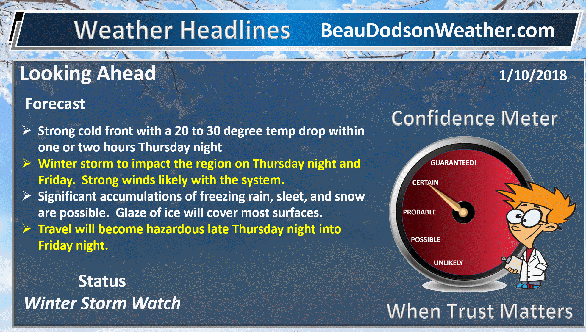
What I know:
- A cold front will push across the region on Thursday night and Friday morning. There will be a 20 to 30 degree temperature drop in as little as one to two hours.
- Scattered showers will form ahead of the front.
- Patchy freezing rain, freezing drizzle, and sleet will form immediately behind the front in the cold sector. It may change to snow as the deeper cold air arrives. Precipitation will rapidly increase in coverage late Thursday night into Friday.
- Accumulation of freezing rain, sleet, and snow will likely occur.
- Bitterly cold air for the weekend.
What I don’t know:
- Exact placement of the heaviest snow and ice totals. It will likely occur east of the Mississippi River.
Scattered thundersleet, thunderice, or thundersnow will be possible with this event. What does that mean? It simply means lightning will be possible with the frozen precipitation. Going out on the limb forecasting that. It seems probable in a few spots.
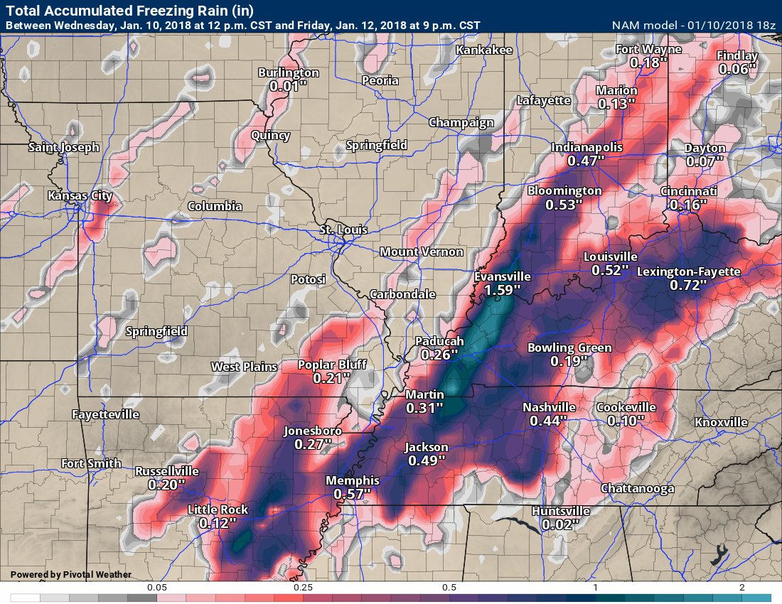
Let’s look at the latest NAM model guidance. NAM is one model of many.
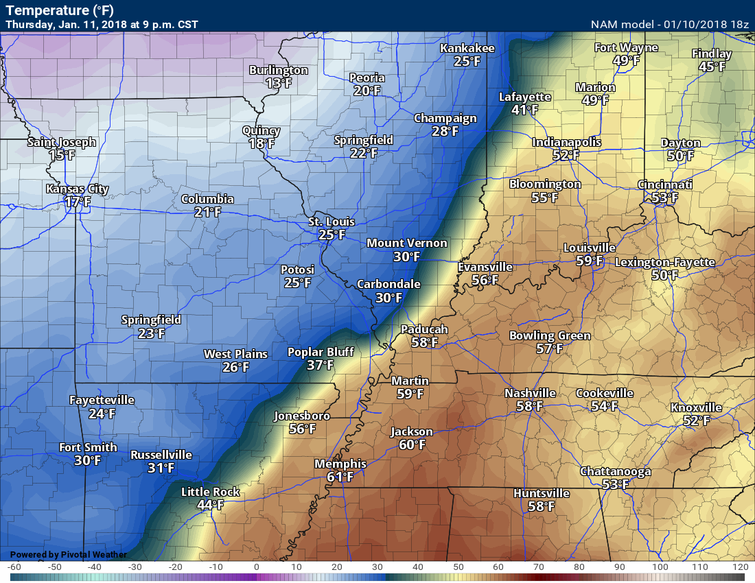
Green represents rain. Red and purple are freezing rain and sleet. Blue would be snow. Darker shades represent heavier totals.
You can see the precipitation develop Thursday night and continues into Friday afternoon.
Temperatures will fall into the 20’s behind the cold front.
.
.
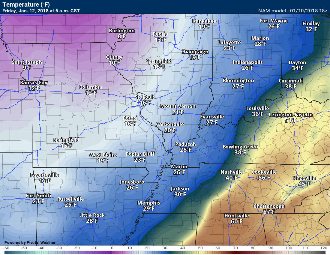
Let me show you the sharp temperature drop behind the cold front.
3 PM Thursday
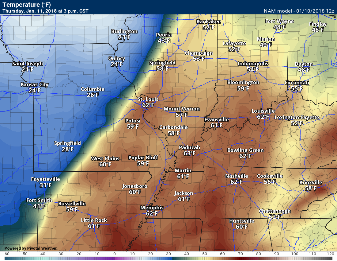
6 PM Thursday
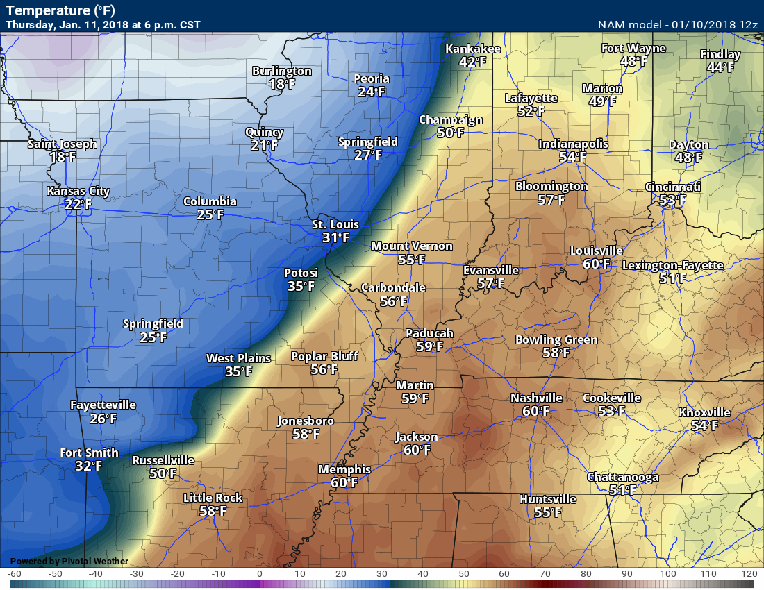
9 PM Thursday
12 AM Friday

6 AM Friday
.
Wintry precipitation will cause significant travel issues across our region on Thursday night into Friday night.
Southeast Missouri may end up with the least impact, but even there there could be some icy road conditions.
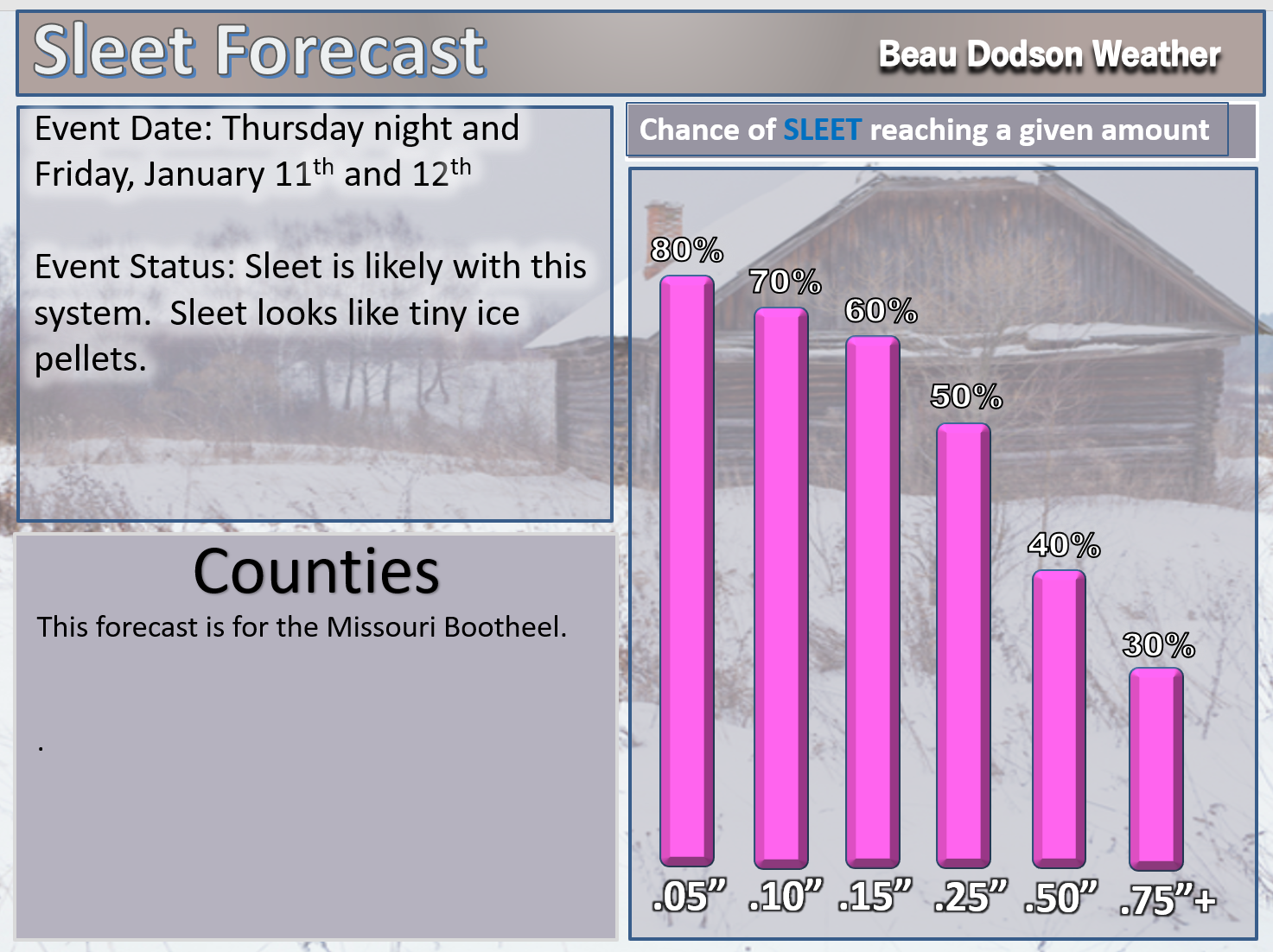
We will need to monitor the Missouri Bootheel for heavier totals. Some debate about that.
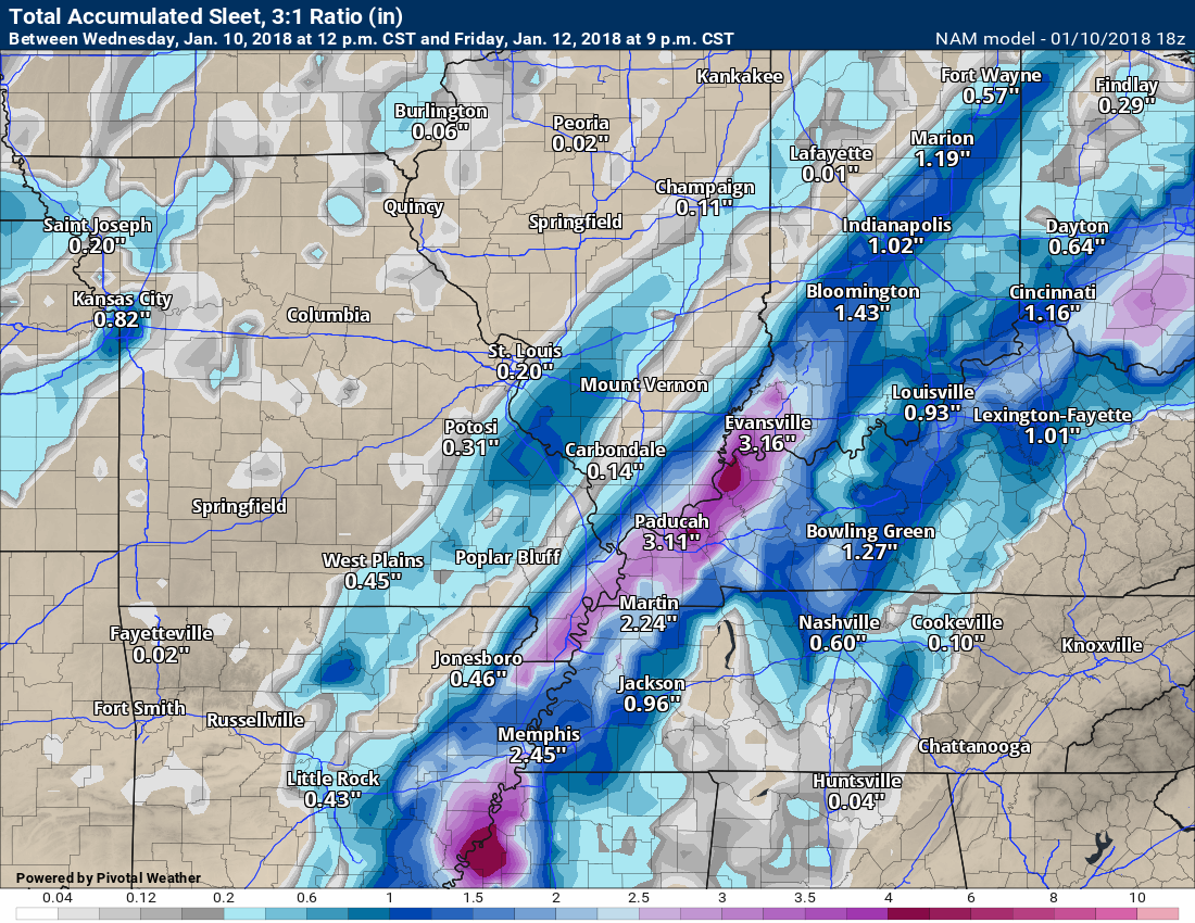
Taken at face value, the NAM drops quite a bit of sleet and freezing rain. Some snow, as well.
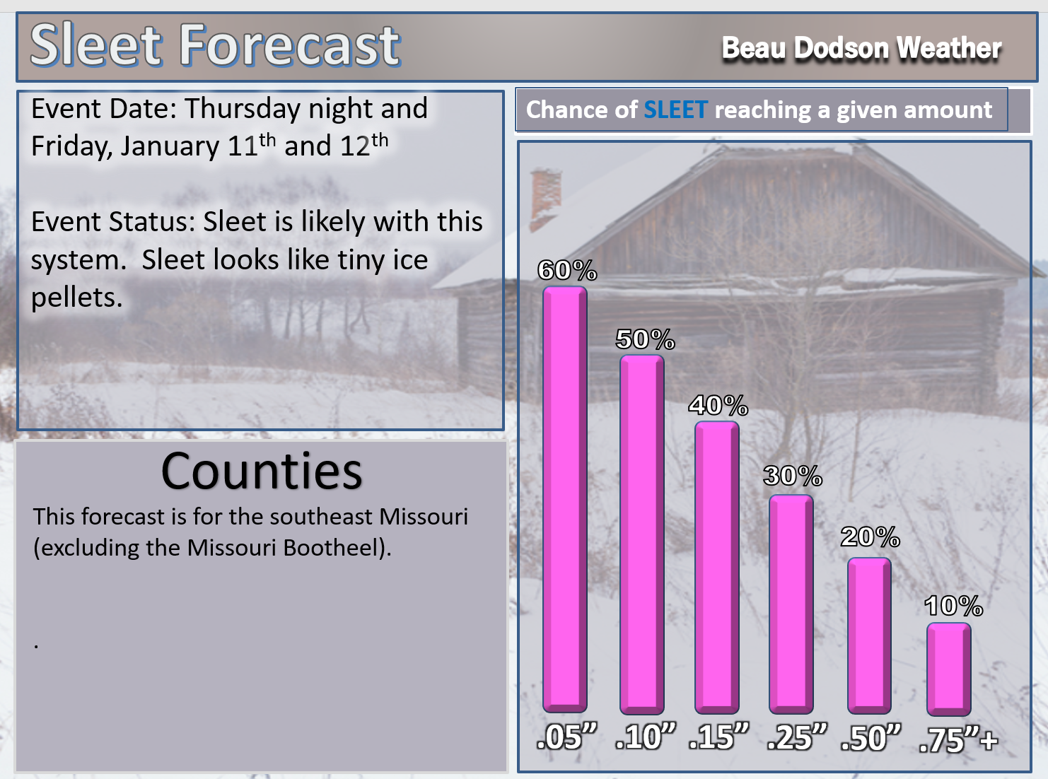
Here is the NAM sleet forecast
This is enough sleet to cause significant travel problems. Icy roads.
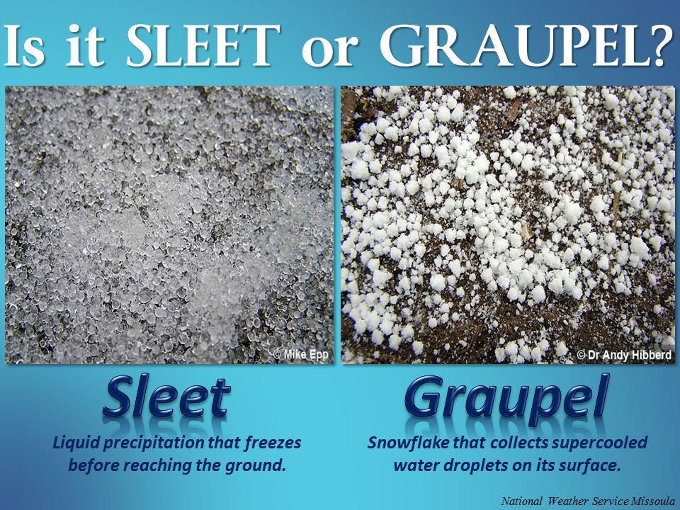
What is sleet?
.
.
One model. One opinion.
Again, this is just a models opinion and is not a forecast.
.
Here is the NAM freezing rain forecast. Cut these numbers at least by 50% (or more).
The NAM would suggest 0.25″ to 0.40″ of freezing rain. The 2009 ice storm was 1″ to 2″ of freezing rain.
Still, freezing rain would cause travel problems and if it lasts long enough, it could bring down some tree limbs or power lines.
Spotty power outages are anticipated.
Again, this is just the NAM models idea of what may happen. Nothing is ever exact. Models aren’t that good.
Take the general idea of placement of freezing rain from this graphic. It may shift a bit west or east. We will need to monitor that part of the forecast.
Again, this is just a models opinion and is not a forecast.
.
.
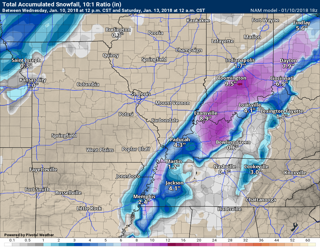
Here is the NAM snow forecast. Snow on top of ice will create hazardous driving conditions.
Not gospel, just guidance. Models are never exact. This just gives you some idea that snow is possible on top of the ice.
Still too early to know about amounts.
Again, this is just a models opinion and is not a forecast.
.
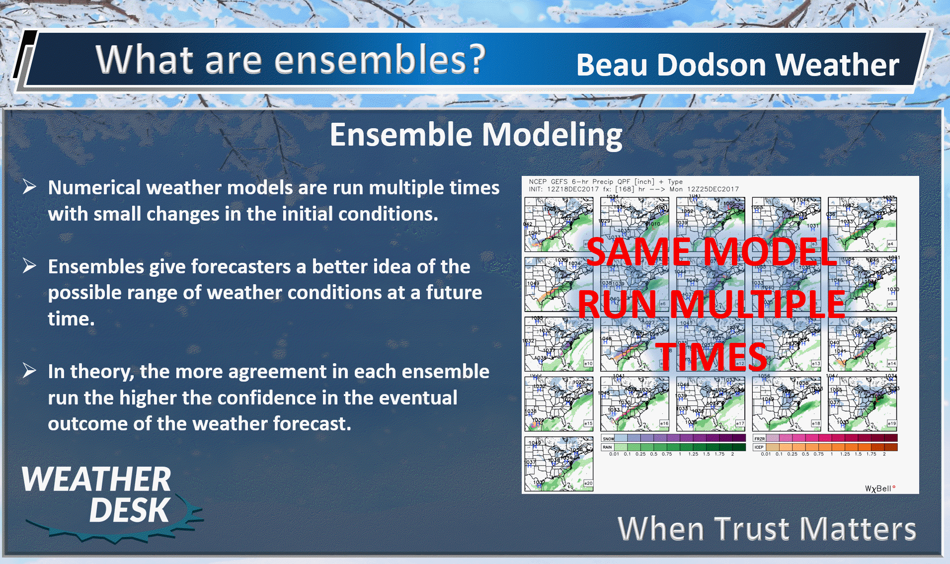
Let’s look at some of the ensembles. Ensembles make it easier to see patterns and trends.
.
.
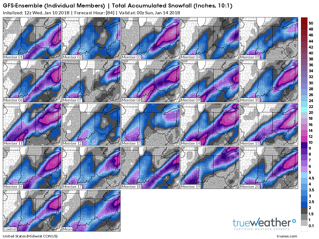
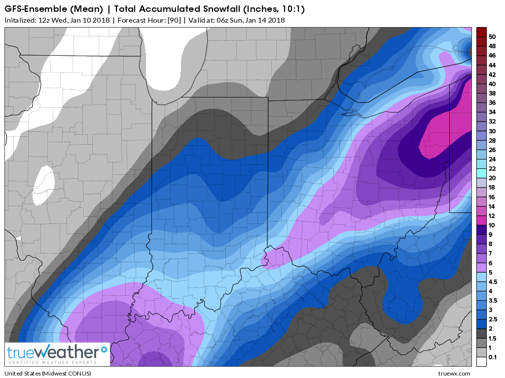
Here is the GFS ensemble guidance.
A lot of agreement in the GFS guidance for a significant winter storm across our region. Each panel is one run of the model. The more that agree, the more confidence one has in the forecast.
What to take from this graphic?
Many of the squares agree with other squares. That means confidence is fairly high that there will be a band of wintry precipitation across our region Thursday night into Friday evening. Ending from west to east.
That there is a lot of agreement in the model guidance for significant wintry precipitation in our region. Ignore the exact amounts shown.
The data is leaning more our eastern counties for the bigger totals vs west. There is still time, however, for adjustments.
.
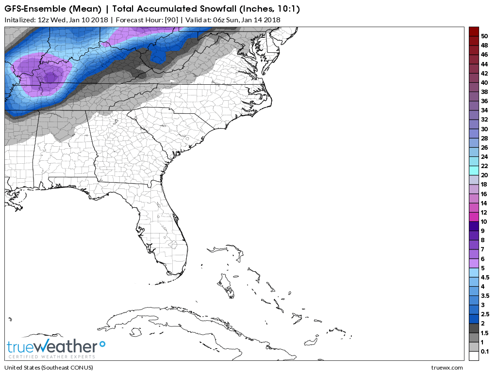
This is the MEAN of the ensembles
Keep in mind, this is snow, sleet, and freezing rain combined.
The numbers are too large. It doesn’t separate out the sleet and so on.
What to take from this graphic?
That there is a lot of agreement in the model guidance for significant wintry precipitation in our region. Ignore the exact amounts shown.
Zoomed out
What to take from this graphic?
That there is a lot of agreement in the model guidance for significant wintry precipitation in our region. Ignore the exact amounts shown.
So what do the above maps tell us?
They tell us that there is strong agreement for heavy wintry precipitation across at least a portion of the region.
The highest totals may end up over southeast Illinois, western Kentucky, and perhaps portions of western Tennessee.
The further west you travel, the less likely for higher totals.
Either way, freezing rain and sleet will cause icy roads across most of the area.
Plan on icy road conditions late Thursday night into Saturday.
The cold air will be with us through at least Wednesday. Highs in the 20’s and lows in the teens. If we have snow or ice, then temperatures could drop into the single digits by Sunday morning and again on Tuesday morning.
This will be dependent on snow or ice cover.
.
Beau’s Winter Weather Outlook
.
.
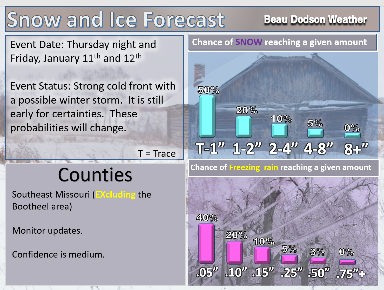
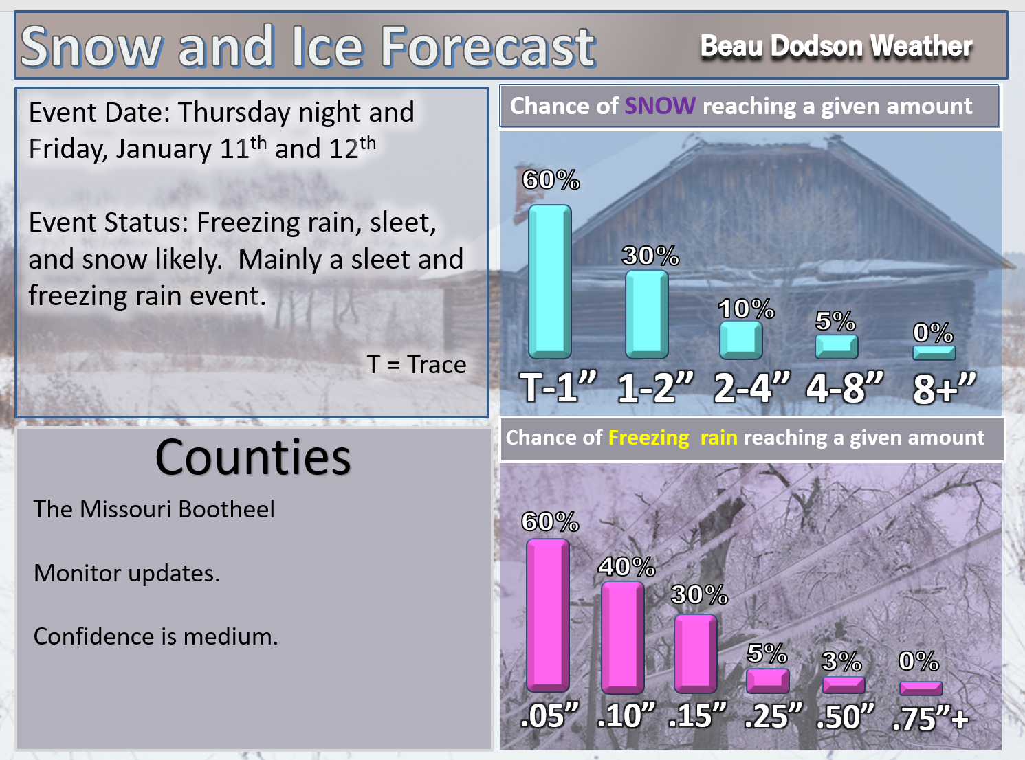
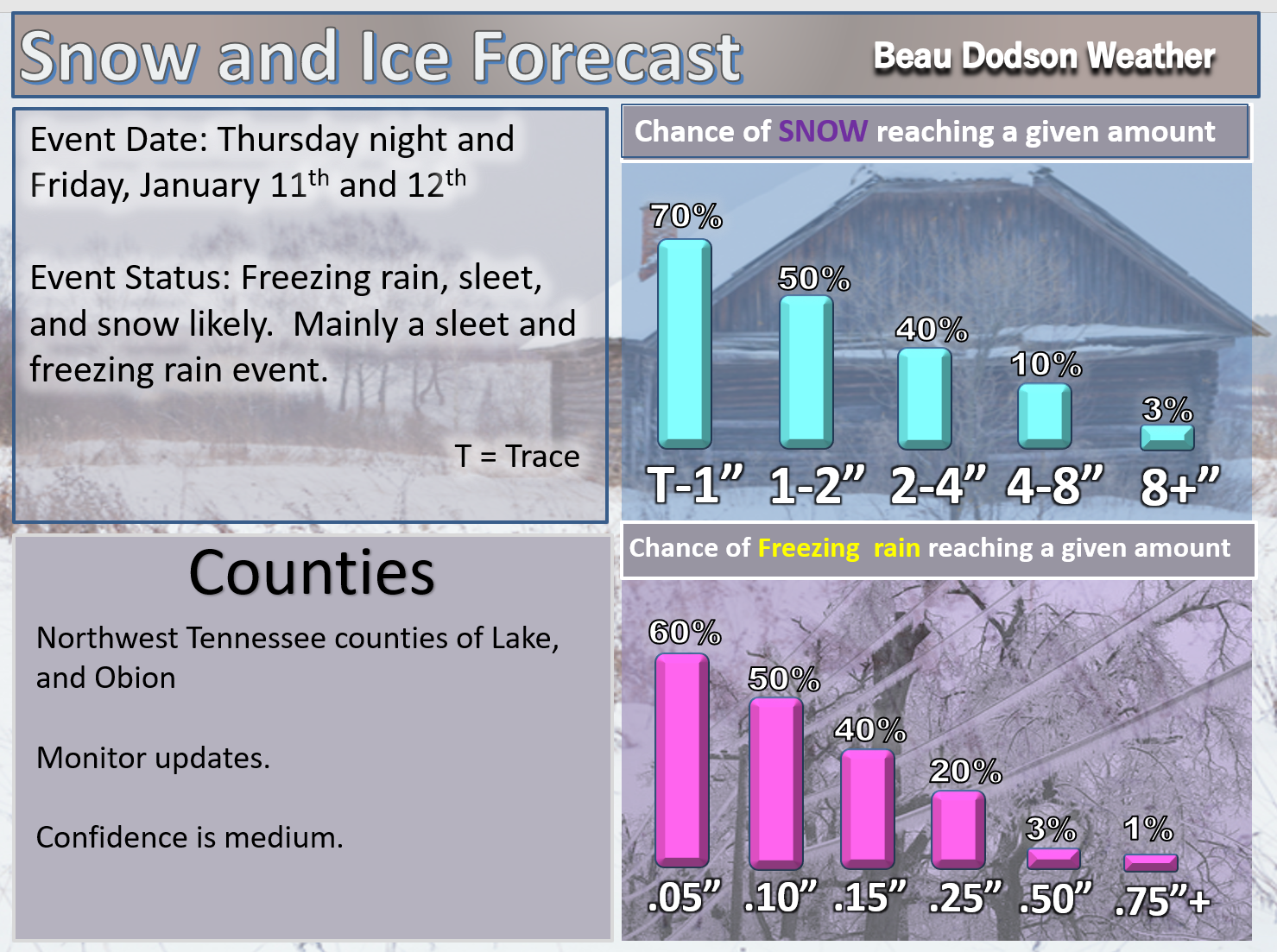
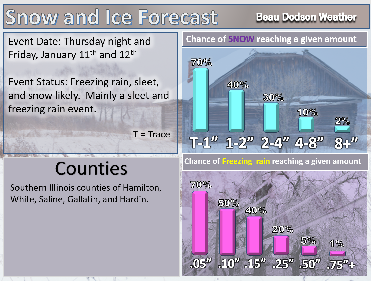
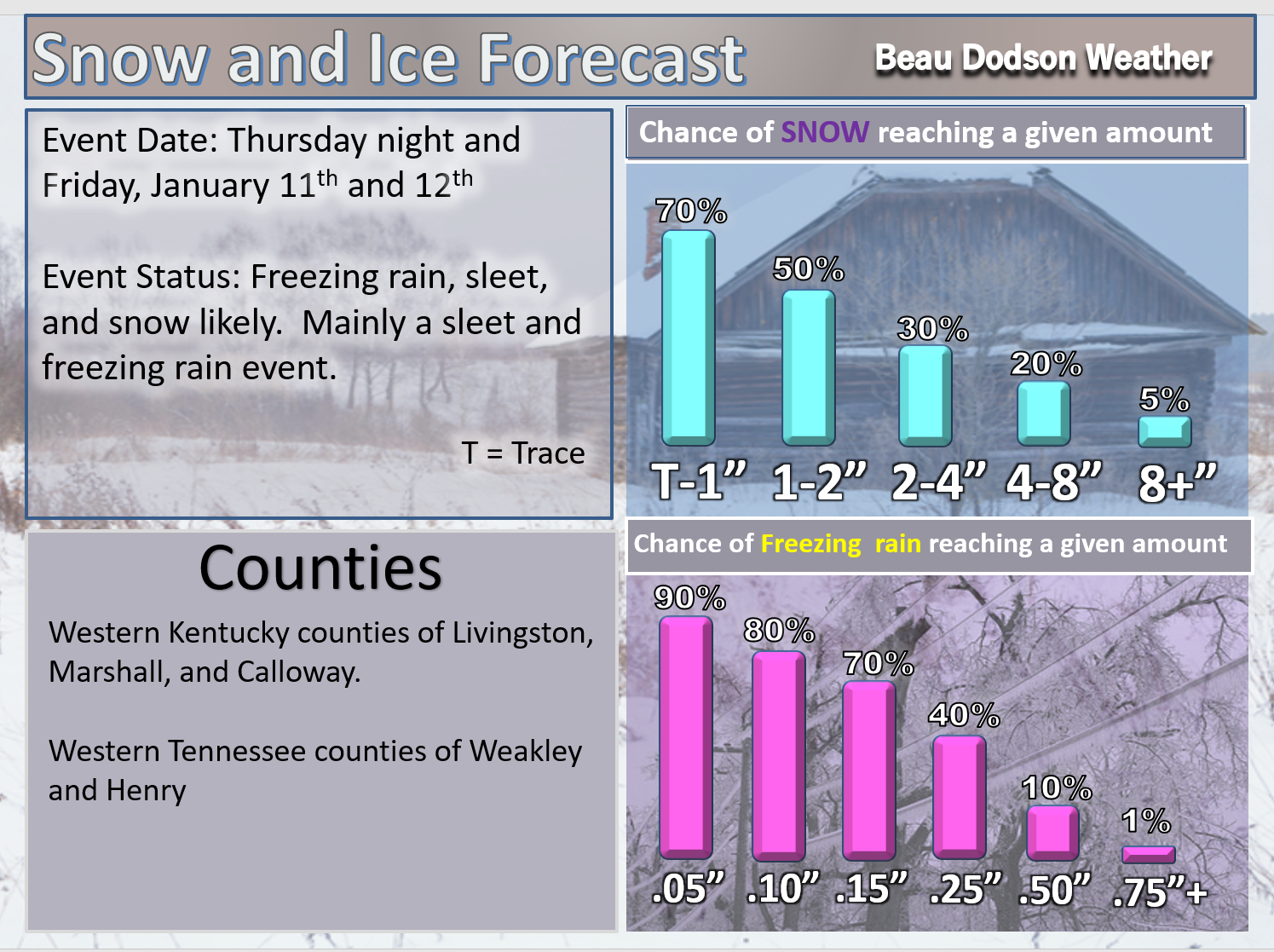
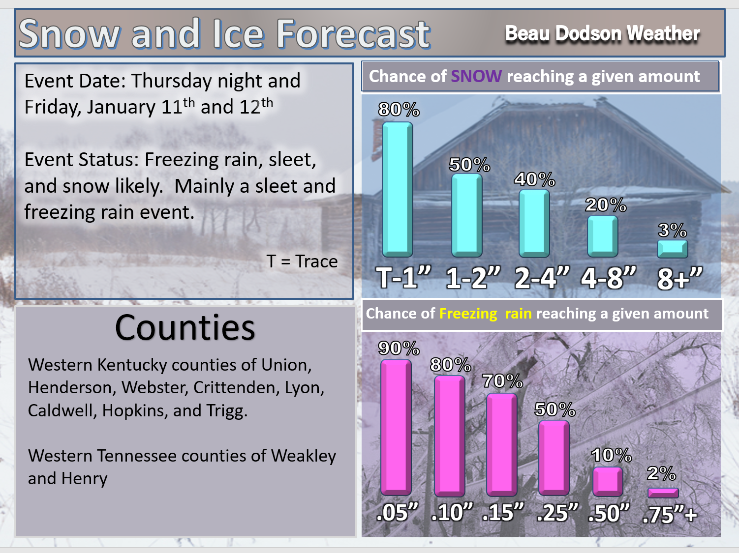
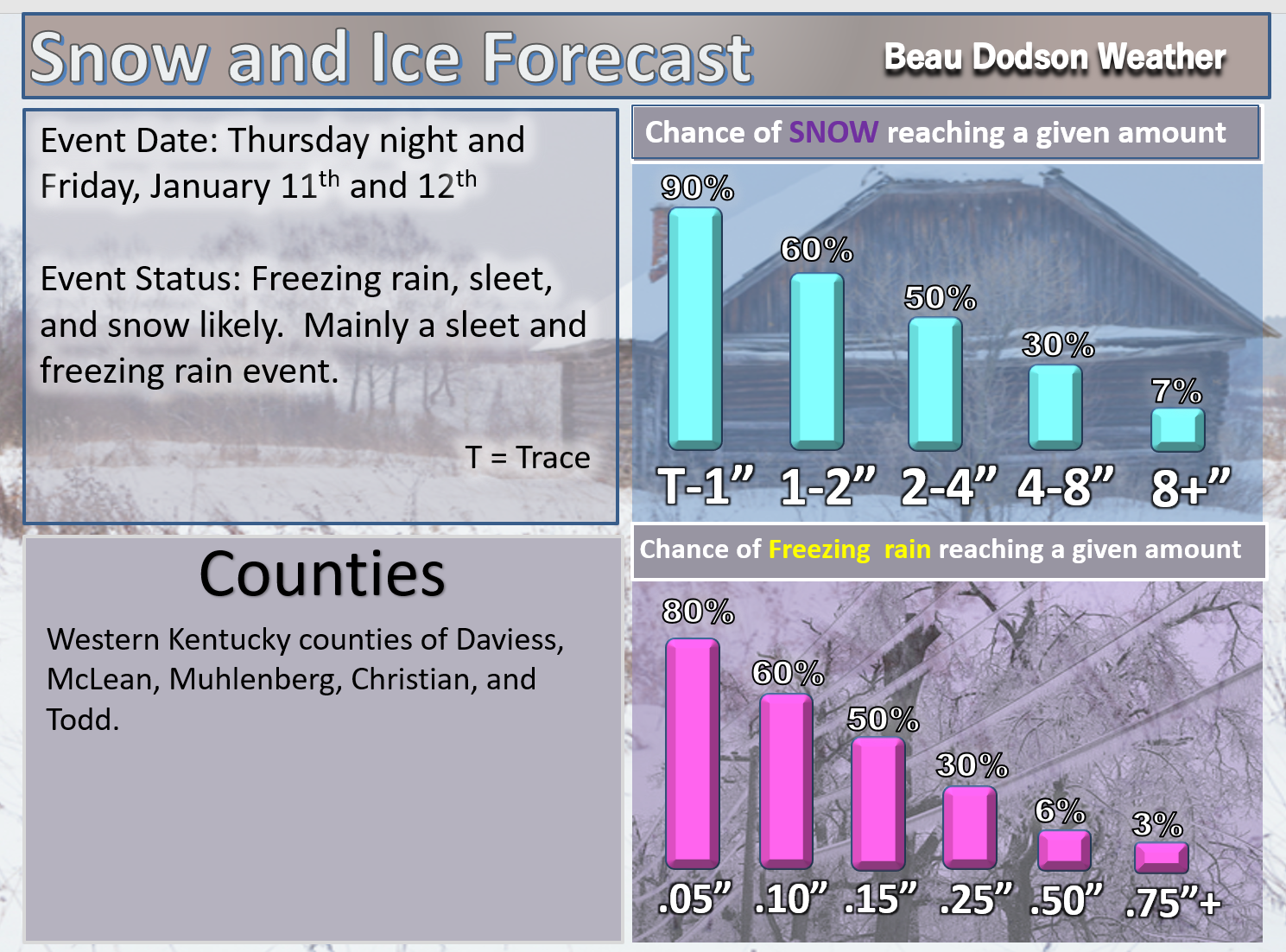
Here are my latest snow probability maps for the week ahead.
I am monitoring the potential of winter precipitation Thursday night into Friday night/Saturday.
There is the potential for accumulating snow or ice. Monitor updates moving forward.
T-1″ means a trace to one inch.
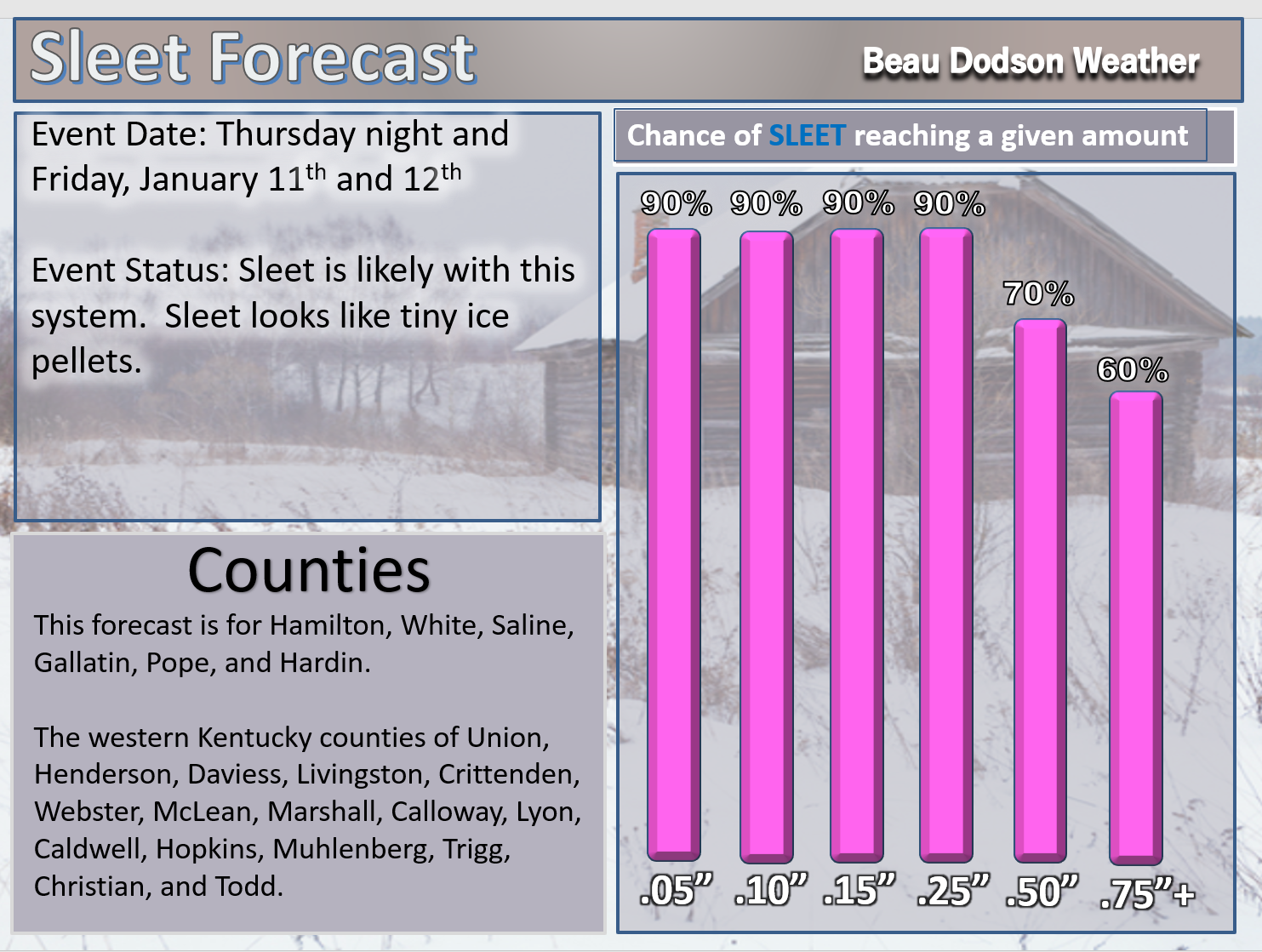
Sleet forecast (sleet looks like small ice pellets). Sleet does not stick to power lines. Freezing rain sticks to power lines.
.

.
These numbers do not include sleet. The sleet forecast is above.
.
.

.
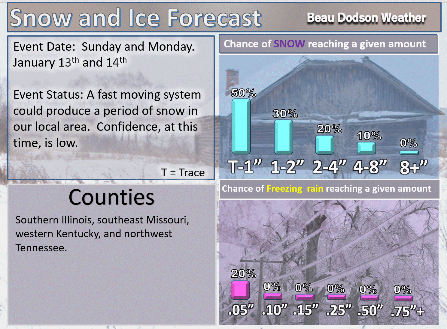
A fast moving system could deliver light snow to portions of the region on Sunday and Monday. It is still early to know the exact track of the system.
These numbers will need adjusting moving forward.
T-1″ means a trace to one inch.
Sometimes these type of systems overachieve. Let’s monitor trends.
.
.
Have you subscribed to Weather Talk? If not, here is your chance!
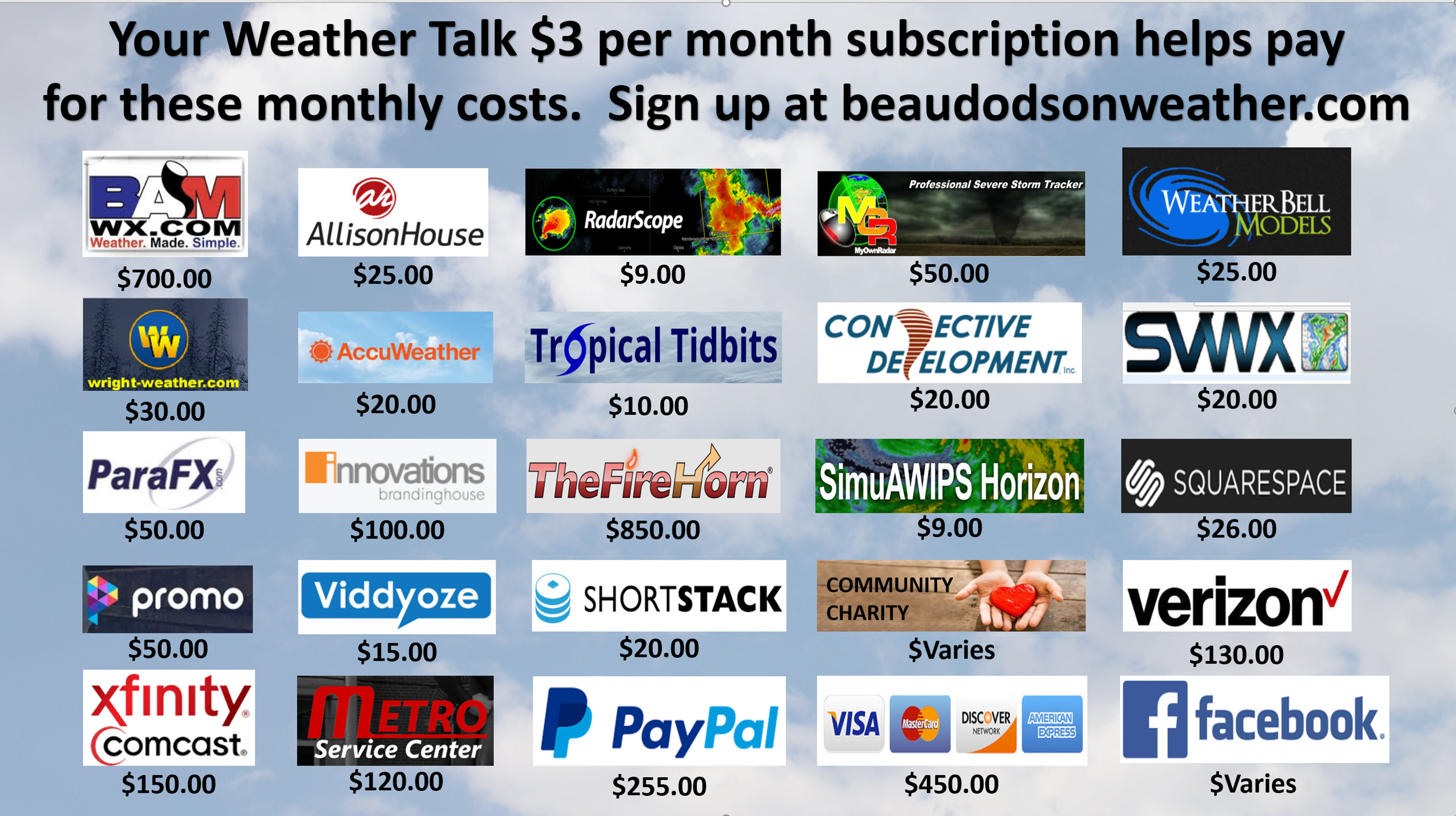
Normal monthly operating costs, for Weather Talk, ranges from $1500 to $2000.
Here are my monthly out of pocket expenses
.
.
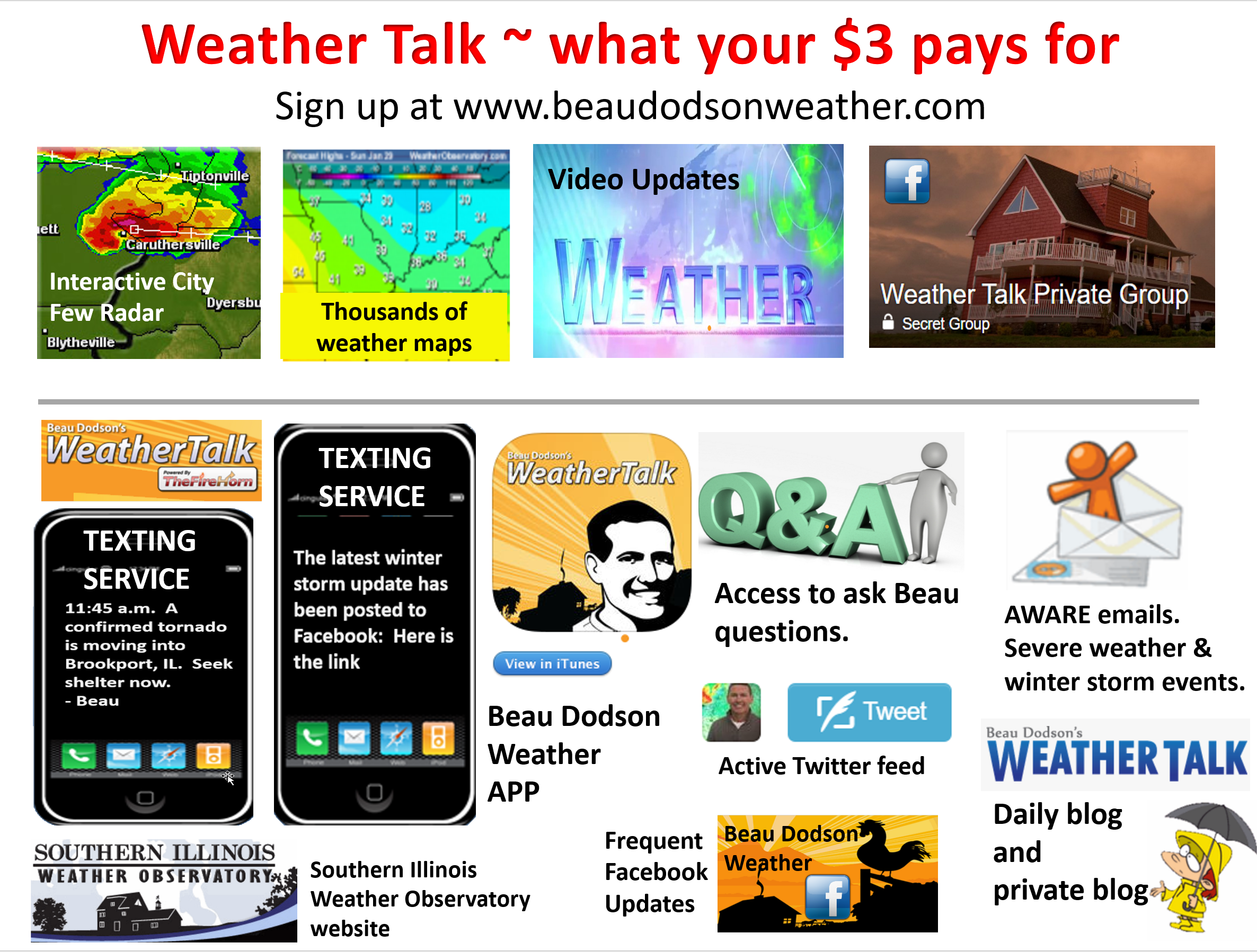
Your $3 subscription allows you access to these products
.
.
If you would like to support this data, then please subscribe. Your $3 a month helps cover the costs of the weather graphics, videos, and my time.
You may choose app/text notifications for my Facebook and blog updates. I will send you a link to the latest updates via the app/text.
You may subscribe at www.beaudodsonweather.com
Once you subscribe you can choose from four different app/text options.
.
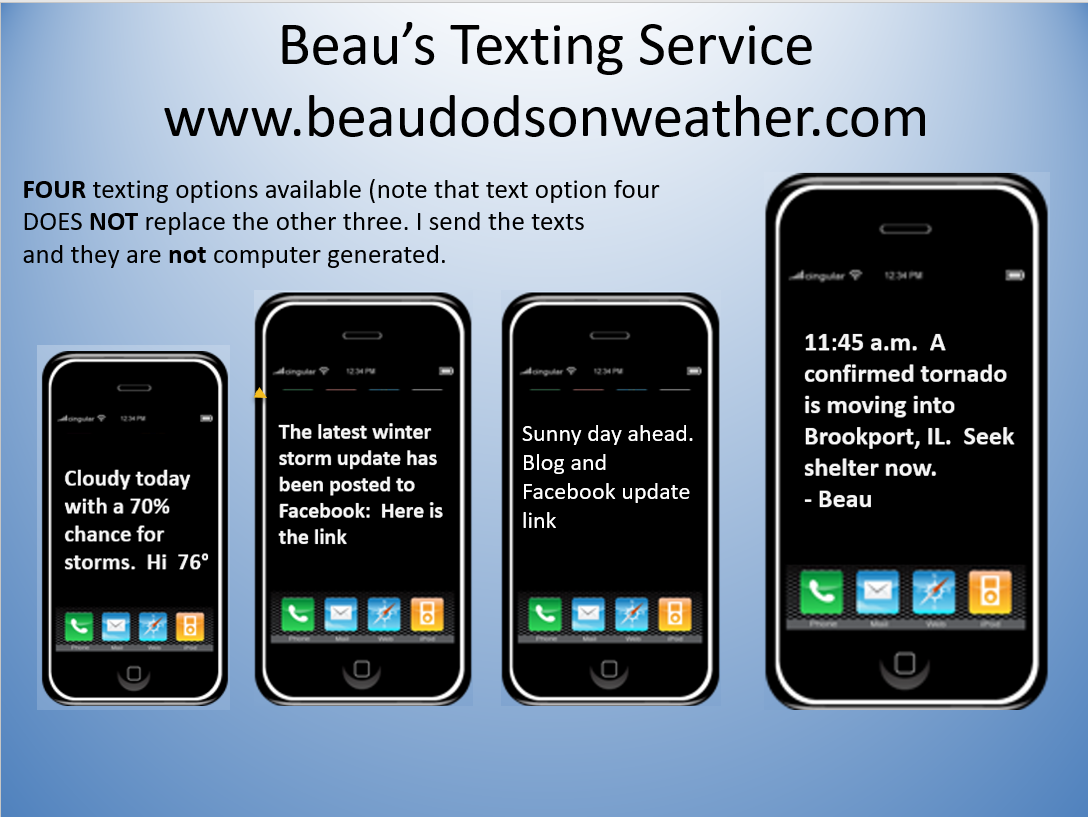
Here are the four options.
.


We offer regional radars and local city radars – if a radar does not update then try another one. Occasional browsers need their cache cleared. You may also try restarting your browser. This will usually fix any problems.
During the winter you can track snow and ice by clicking the winterize button on the local city view interactive radars.
You may email me at beaudodson@usawx.com
Interactive Weather Radar Page. Choose the city nearest your location: Click this link
National interactive radar: Click this link.