
This forecast update covers far southern Illinois, far southeast Missouri, and far western Kentucky. See the coverage map on the right side of the blog.
If you find value in this page and the other weather products on the Weather Observatory web-site then consider making a donation to keep everything up and running. It does cost quite a bit of money each month to run the radars, data feeds, hosting of sites, and more. You can give by visiting our donation page.
Thursday – Mostly cloudy at times – becoming partly sunny. Cold. High temperatures won’t get out of the 30’s. Northwest winds at 10 – 15 mph.
Thursday night – Mostly clear and cold. Low temperatures in the middle 20’s. North winds at 10 mph.
Friday – Some clouds to deal with. Still cool. High temperatures in the 40’s. Southeast winds at 10-15 mph. Gusty at times.
Friday night – Partly cloudy sky conditions. Not quite as cold as recent nights. Low temperatures in the lower 40’s South winds at 10 mph.
Saturday – Becoming clouds. Scattered light rain or sprinkles possible. High temperatures in the middle to upper 50’s. South winds at 10-15 mph.
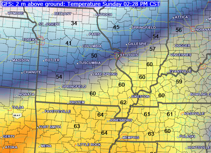
Current Temperatures


An explanation of what is happening in the atmosphere over the coming days.
Short and sweet…
Calm weather today through Friday. Cold temperatures, but no precipitation to deal with.
Some morning flurries over southern IL and northwest KY (today). Again, some black ice or patchy slick spots in areas that had snow yesterday. This should clear up as the sun pokes through the clouds today.
The atmosphere does warm up a bit this coming weekend and that may mean clouds and light rain chances by Saturday night into Sunday.
I am watching a strong cold front that will bring colder air back into the region by Monday or Tuesday.

No major changes.

No concerns!

The Wild Card gives you an idea of what might change that would cause the forecast to bust. A busted forecast means a forecast that does not verify. For example, if a winter storm (the area of low pressure) shifts its track 50 miles further south than expected, then that could cause a dramatic change in how much snow might or might not accumulate.
Wild card in this forecast – No wild card today. Enjoy the holiday.

Will I need to take action?
No. A few patches of black ice this morning. Mainly in area that had light snow overnight.

Please visit your local National Weather Service Office by clicking here. The National Weather Service Office, for our region, is located in Paducah, Kentucky.
No snow or ice through Sunday. I am watching the overall pattern as we push into Monday and Tuesday. We might be in for a bit of a roller-caster when it comes to temperatures and maybe precipitation. Stay tuned as we push further into the weekend and next week.
Watch out this morning for patchy black ice. Some light snow and flurries fell overnight in the area. This was mainly over southern IL and northwest KY

Some indications that we will enter a more active pattern as we push into Sunday and through next week. We might be in for a bit of a roller-caster ride when it comes to temperatures and even precipitation.
We will warm up some this weekend. A strong cold front may sweep through the area on Monday. This will need to be watch. If we end up with rain then it could change to a wintry mix as the cold air moves in. Very low confidence in how the Monday and Tuesday time frame unfolds.

Current WARNINGS (a warning means take action now). Click on your county to drill down to the latest warning information. Keep in mind that there can be a 2-3 minute delay in the updated warning information.
I strongly encourage you to use a NOAA Weather Radio or warning cell phone app for the most up to date warning information. Nothing is faster than a NOAA weather radio.


Missouri Warnings

Illinois Warnings

Kentucky Warnings
Many of my graphics are from www.weatherbell.com – a great resource for weather data, model data, and more


This blog was inspired by ABC 33/40’s Alabama Weather Blog – view their blog
Current tower cam view from the Weather Observatory- Click here for all cameras.

Southern Illinois Weather Observatory

The Weather Observatory

Southern Illinois Weather Observatory
WSIL TV 3 has a number of tower cameras. Click here for their tower camera page & Illinois Road Conditions

Marion, Illinois
WPSD TV 6 has a number of tower cameras. Click here for their tower camera page & Kentucky Road Conditions & Kentucky Highway and Interstate Cameras

Downtown Paducah, Kentucky
Benton, Kentucky Tower Camera – Click here for full view

Benton, Kentucky

I24 Paducah, Kentucky

I24 Mile Point 9 – Paducah, KY

You can sign up for my AWARE email by clicking here I typically send out AWARE emails before severe weather, winter storms, or other active weather situations. I do not email watches or warnings. The emails are a basic “heads up” concerning incoming weather conditions