
WeatherTalk monthly operating costs can top $2000.00. Your $5 subscription helps pay for those costs. I work for you.
The $5 will allow you to register up to seven phones!
For $5 a month you can receive the following. You may choose to receive these via your WeatherTalk app or regular text messaging.
Severe weather app/text alerts from my keyboard to your app/cell phone. These are hand typed messages from me to you. During tornado outbreaks, you will receive numerous app/text messages telling you exactly where the tornado is located.
- Daily forecast app/texts from my computer to your app/cell phone.
- Social media links sent directly to your app/cell phone. When I update the blog, videos, or Facebook you will receive the link.
- AWARE emails. These emails keep you well ahead of the storm. They give you several days of lead time before significant weather events.
- Direct access to Beau via text and email. Your very own personal meteorologist. I work for you!
- Missouri and Ohio Valley centered video updates
- Long-range weather videos
- Week one, two, three and four temperature and precipitation outlooks.
Monthly outlooks. - Your subscription also will help support several local charities.
Would you like to subscribe? Subscribe at www.beaudodsonweather.com
Typical progression on a severe weather day for subscribers.


I encourage subscribers to use the app vs regular text messaging. We have found text messaging to be delayed during severe weather. The app typically will receive the messages instantly. I recommend people have three to four methods of receiving their severe weather information.
Remember, my app and text alerts are hand typed and not computer generated. You are being given my personal attention during significant weather events.

WWW.WEATHERTALK.COM subscribers, here is my day to day schedule for your weather products.
These are bonus videos and maps for subscribers. I bring these to you from the BAMwx team. I pay them to help with videos.
The Ohio and Missouri Valley videos cover most of our area. They do not have a specific Tennessee Valley forecast but may add one in the future.
The long-range video is technical. Over time, you can learn a lot about meteorology from the long range video. Just keep in mind, it is a bit more technical.


Subscribe at www.weathertalk.com
![]()

![]()
February 8, 2019
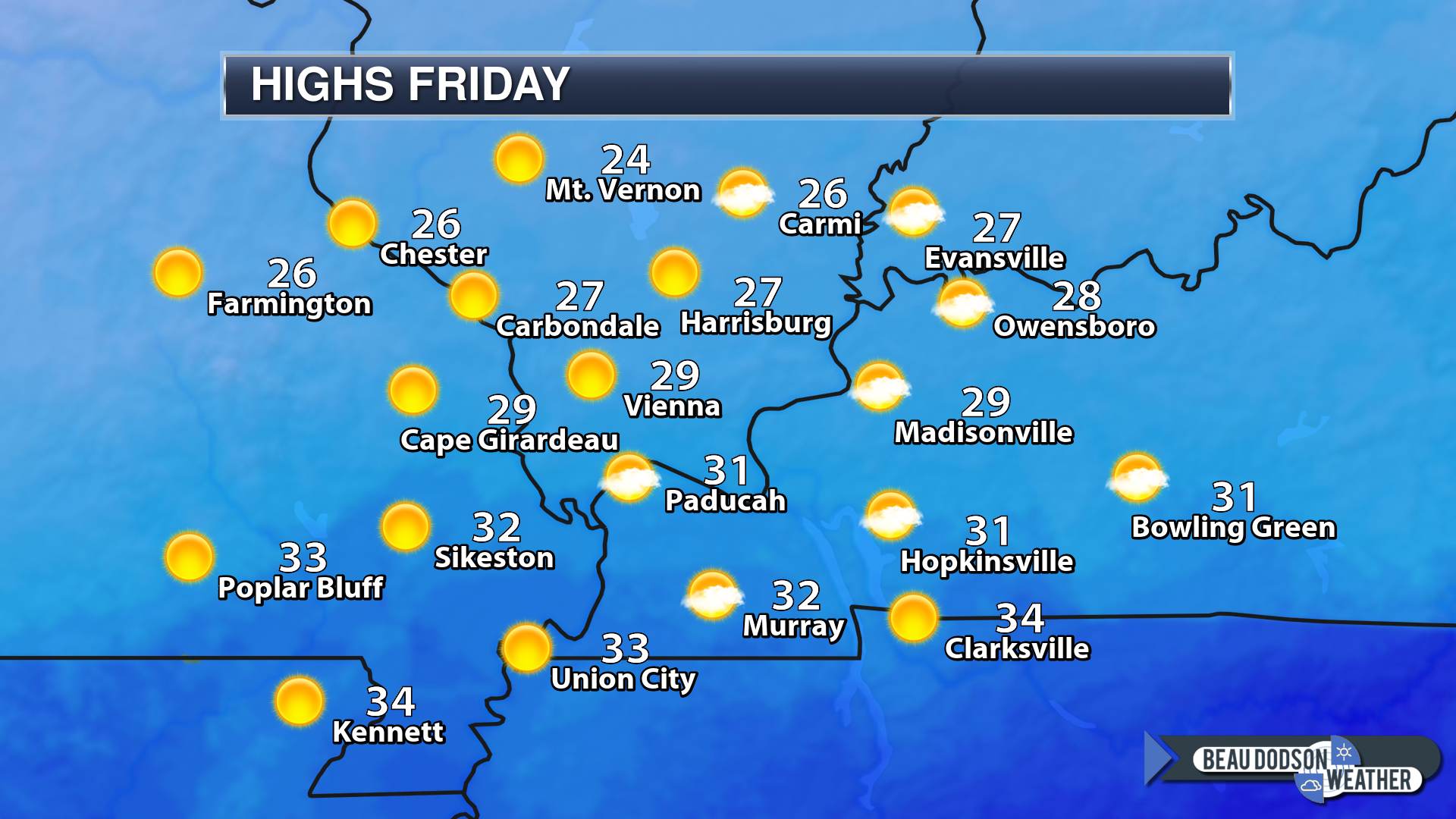
Friday’s Forecast: Mostly sunny and colder.
My confidence in the forecast verifying: High (80% confidence in the forecast)
Temperature range: MO Bootheel 32° to 35° SE MO 28° to 34° South IL 26° to 34° West KY 32° to 34° NW TN 34° to 36°
Wind direction and speed: Northwest at 10 to 20 mph
Wind chill or heat index (feels like) temperature forecast: 15 to 25
What is the chance/probability of precipitation? MO Bootheel 0% MO 0% IL 0% KY 0% TN 0%
Note, what does the % chance actually mean? A 20% chance of rain does not mean it won’t rain. It simply means most areas will remain dry.
Coverage of precipitation: None
Is flash flooding anticipated? No
Will there be accumulating snow or ice? No
Will non-accumulating snow or ice occur? No
Are icy road conditions anticipated? No
Is severe weather expected? No
The NWS officially defines severe weather as 58 mph wind or great, 1″ hail or larger, and/or tornadoes
Is lightning anticipated? No
What impacts are anticipated from the weather? None
Should I cancel my outdoor plans? No
UV Index: 3 Moderate
Sunrise: 6:52 AM
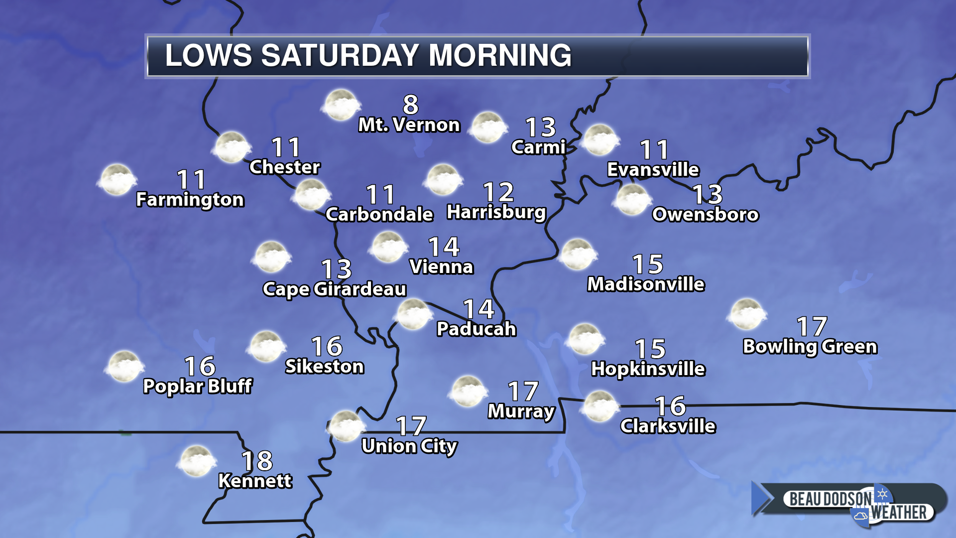
Friday night Forecast: Mostly clear and cold.
My confidence in the forecast verifying: High (70% confidence in the forecast)
Temperature range: MO Bootheel 22° to 24° SE MO 16° to 20° South IL 10° to 15° West KY 18° to 24° NW TN 20° to 24°
Wind direction and speed: North at 5 to 10 mph
Wind chill or heat index (feels like) temperature forecast: 10 to 15
What is the chance/probability of precipitation? MO Bootheel 0% MO 0% IL 0% KY 0% TN 0%
Note, what does the % chance actually mean? A 20% chance of rain does not mean it won’t rain. It simply means most areas will remain dry
Coverage of precipitation: None
Is flash flooding anticipated? No
Will there be accumulating snow or ice? No
Will non-accumulating snow or ice occur? No
Are icy road conditions anticipated? No
Is severe weather expected? No
The NWS officially defines severe weather as 58 mph wind or great, 1″ hail or larger, and/or tornadoes
Is lightning anticipated? No
What impacts are anticipated from the weather? None
Should I cancel my outdoor plans? No
Sunset: 5:27 PM
Moonrise: 9:03 AM
The phase of the moon: Waxing Crescent
Moonset: 9:03 PM
February 9, 2019
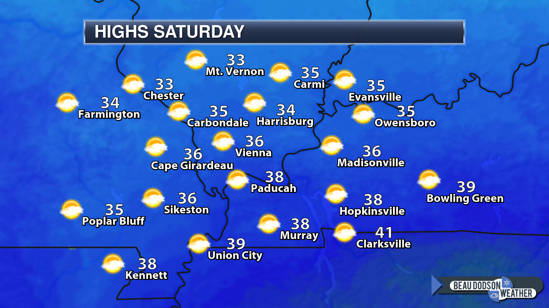
Saturday’s Forecast: Partly sunny. Cold.
My confidence in the forecast verifying: High (70% confidence in the forecast)
Temperature range: MO Bootheel 40° to 44° SE MO 35° to 40° South IL 33° to 36° West KY 36° to 42° NW TN 38° to 42°
Wind direction and speed: East at 5 to 10 mph.
Wind chill or heat index (feels like) temperature forecast: 30 to 35
What is the chance/probability of precipitation? MO Bootheel 0% MO 0% IL 0% KY 0% TN 0%
Note, what does the % chance actually mean? A 20% chance of rain does not mean it won’t rain. It simply means most areas will remain dry.
Coverage of precipitation: None
Is flash flooding anticipated? No
Will there be accumulating snow or ice? No
Will non-accumulating snow or ice occur? No
Are icy road conditions anticipated? No
Is severe weather expected? No
The NWS officially defines severe weather as 58 mph wind or great, 1″ hail or larger, and/or tornadoes
Is lightning anticipated? No
What impacts are anticipated from the weather? None
Should I cancel my outdoor plans? No
UV Index: 3 Moderate
Sunrise: 6:51 AM
Saturday night Forecast: Increasing clouds. A chance of freezing rain, sleet, and snow (light). Best chance would be across southeast Missouri after midnight. Whether it spreads further east is still questionable.
My confidence in the forecast verifying: Medium (60% confidence in the forecast)
Temperature range: MO Bootheel 30° to 35° SE MO 25° to 30° South IL 24° to 28° West KY 28° to 32° NW TN 30° to 34°
Wind direction and speed: East at 6 to 12 mph
Wind chill or heat index (feels like) temperature forecast: 30 to 40
What is the chance/probability of precipitation? MO Bootheel 30% MO 30% IL 10% KY 10% TN 10%
Note, what does the % chance actually mean? A 20% chance of rain does not mean it won’t rain. It simply means most areas will remain dry
Coverage of precipitation: Scattered late (SE MO)
Is flash flooding anticipated? No
Will there be accumulating snow or ice? Possible after midnight over SE MO
Will non-accumulating snow or ice occur? Yes
Are icy road conditions anticipated? Roads will be cold. If precipitation does occur then it would stick.
Is severe weather expected? No
The NWS officially defines severe weather as 58 mph wind or great, 1″ hail or larger, and/or tornadoes
Is lightning anticipated? No
What impacts are anticipated from the weather? Monitor updates concerning a chance of a wintry mix.
Should I cancel my outdoor plans? No
Sunset: 5:28 PM
Moonrise: 9:32 AM
The phase of the moon: Waxing Crescent
Moonset: 10:00 PM
![]()
February 10, 2019
Sunday’s Forecast: Cloudy with any wintry mix changing to all rain as temperatures warm above freezing. Precipitation totals should be light.
My confidence in the forecast verifying: Medium (40% confidence in the forecast)
Temperature range: MO Bootheel 43° to 46° SE MO 38° to 42° South IL 38° to 44° West KY 43° to 46° NW TN 43° to 46°
Wind direction and speed: East at 6 to 12 mph
Wind chill or heat index (feels like) temperature forecast: 30 to 40
What is the chance/probability of precipitation? MO Bootheel 60% MO 60% IL 60% KY 60% TN 60%
Note, what does the % chance actually mean? A 20% chance of rain does not mean it won’t rain. It simply means most areas will remain dry.
Coverage of precipitation: Becoming numerous.
Is flash flooding anticipated? No
Will there be accumulating snow or ice? Possible early (in areas with temperatures below freezing)
Will non-accumulating snow or ice occur? Early in the day, it is possible where temperatures remain below freezing.
Are icy road conditions anticipated? Possible early in the day before temperatures rise above freezing.
Is severe weather expected? No
The NWS officially defines severe weather as 58 mph wind or great, 1″ hail or larger, and/or tornadoes
Is lightning anticipated? No
What impacts are anticipated from the weather? Icy roads are possible early in the day (in areas where temperatures remain below freezing briefly) Wet roadways during the afternoon.
Should I cancel my outdoor plans? Have a plan B and monitor updates.
UV Index: 1 Low
Sunrise: 6:50 AM
Sunday night Forecast: Cloudy. Rain showers. Rain may mix with or change to snow or a wintry mix. It may remain all rain over the southern half of the region. Monitor the forecast for more specific details.
My confidence in the forecast verifying: Medium (40% confidence in the forecast)
Temperature range: MO Bootheel 34° to 36° SE MO 30° to 35° South IL 32° to 34° West KY 34° to 38° NW TN 34° to 38°
Wind direction and speed: Variable wind 5 to 10 mph
Wind chill or heat index (feels like) temperature forecast:
What is the chance/probability of precipitation? MO Bootheel 60% MO 60% IL 50% KY 60% TN 70%
Note, what does the % chance actually mean? A 20% chance of rain does not mean it won’t rain. It simply means most areas will remain dry
Coverage of precipitation: Scattered to numerous
Is flash flooding anticipated? No
Will there be accumulating snow or ice? Monitor
Will non-accumulating snow or ice occur? Yes
Are icy road conditions anticipated? Monitor
Is severe weather expected? No
The NWS officially defines severe weather as 58 mph wind or great, 1″ hail or larger, and/or tornadoes
Is lightning anticipated? No
What impacts are anticipated from the weather? Wet roadways. Monitor for the risk of icy roads.
Should I cancel my outdoor plans? Have a plan B
Sunset: 6:50 PM
Moonrise: 10:00 AM
The phase of the moon: Waxing Crescent
Moonset: 10:58 PM
February 11, 2019
Monday’s Forecast: Cloudy with rain showers.
My confidence in the forecast verifying: Medium (60% confidence in the forecast)
Temperature range: MO Bootheel 45° to 50° SE MO 42° to 44° South IL 43° to 46° West KY 44° to 48° NW TN 45° to 50°
Wind direction and speed: North and northeast at 5 to 10 mph with gusts to 15 mph
Wind chill or heat index (feels like) temperature forecast:
What is the chance/probability of precipitation? MO Bootheel 80% MO 70% IL 70% KY 70% TN 80%
Note, what does the % chance actually mean? A 20% chance of rain does not mean it won’t rain. It simply means most areas will remain dry.
Coverage of precipitation: Numerous
Is flash flooding anticipated? Monitor
Will there be accumulating snow or ice? No
Will non-accumulating snow or ice occur? No
Are icy road conditions anticipated? No
Is severe weather expected? No
The NWS officially defines severe weather as 58 mph wind or great, 1″ hail or larger, and/or tornadoes
Is lightning anticipated? Monitor
What impacts are anticipated from the weather? Wet roadways. Monitor the risk of flooding.
Should I cancel my outdoor plans? Have a plan B
UV Index: 1 Low
Sunrise: 6:49 AM
Monday night Forecast: Cloudy. Rain showers.
My confidence in the forecast verifying: Medium (40% confidence in the forecast)
Temperature range: MO Bootheel 40° to 45° SE MO 34° to 38° South IL 34° to 36° West KY 43° to 46° NW TN 45° to 50°
Wind direction and speed: East and northeast at 8 to 16 mph
Wind chill or heat index (feels like) temperature forecast:
What is the chance/probability of precipitation? MO Bootheel 80% MO 80% IL 80% KY 80% TN 80%
Note, what does the % chance actually mean? A 20% chance of rain does not mean it won’t rain. It simply means most areas will remain dry
Coverage of precipitation: Numerous
Is flash flooding anticipated? Monitor
Will there be accumulating snow or ice? No
Will non-accumulating snow or ice occur? No
Are icy road conditions anticipated? No
Is severe weather expected? No
The NWS officially defines severe weather as 58 mph wind or great, 1″ hail or larger, and/or tornadoes
Is lightning anticipated? Monitor
What impacts are anticipated from the weather? Wet roadways. Patchy fog. Monitor the risk of flooding.
Should I cancel my outdoor plans? Have a plan B
Sunset: 5:30 PM
Moonrise: 10:30 AM
The phase of the moon: Waxing Crescent
Moonset: 11:58 PM
Significant changes to the forecast from Tuesday onward. This is why I placed low confidence stamps on this time period.
Model guidance has basically been worthless as far as a system that arrives Sunday into Monday night.
I have increased confidence to the medium category.
February 12, 2019
Tuesday’s Forecast: Partly sunny.
My confidence in the forecast verifying: Medium (40% confidence in the forecast)
Temperature range: MO Bootheel 54° to 58° SE MO 48° to 52° South IL 46° to 52° West KY 54° to 56° NW TN 54° to 58°
Wind direction and speed: West at 10 to 20 mph
Wind chill or heat index (feels like) temperature forecast:
What is the chance/probability of precipitation? MO Bootheel 0% MO 0% IL 0% KY 0% TN 0%
Note, what does the % chance actually mean? A 20% chance of rain does not mean it won’t rain. It simply means most areas will remain dry.
Coverage of precipitation: None
Is flash flooding anticipated? No
Will there be accumulating snow or ice? No
Will non-accumulating snow or ice occur? No
Are icy road conditions anticipated? No
Is severe weather expected? No
The NWS officially defines severe weather as 58 mph wind or great, 1″ hail or larger, and/or tornadoes
Is lightning anticipated? No
What impacts are anticipated from the weather? None
Should I cancel my outdoor plans? No
UV Index: 3 moderate
Sunrise: 6:48 AM
Tuesday night Forecast: Partly cloudy.
My confidence in the forecast verifying: Medium (40% confidence in the forecast)
Temperature range: MO Bootheel 35° to 40° SE MO 25° to 30° South IL 25° to 30° West KY 32° to 36° NW TN 33° to 36°
Wind direction and speed: West and northwest at 5 to 10 mph
Wind chill or heat index (feels like) temperature forecast:
What is the chance/probability of precipitation? MO Bootheel 0% MO 0% IL 0% KY 0% TN 0%
Note, what does the % chance actually mean? A 20% chance of rain does not mean it won’t rain. It simply means most areas will remain dry
Coverage of precipitation: None
Is flash flooding anticipated? No
Will there be accumulating snow or ice? No
Will non-accumulating snow or ice occur? No
Are icy road conditions anticipated? No
Is severe weather expected? No
The NWS officially defines severe weather as 58 mph wind or great, 1″ hail or larger, and/or tornadoes
Is lightning anticipated? No
What impacts are anticipated from the weather? None
Should I cancel my outdoor plans? No
Sunset: 5:32 PM
Moonrise: 11:03 AM
The phase of the moon: First Quarter
Moonset: 12:01 AM
February 13, 2019
Wednesday’s Forecast: Partly sunny.
My confidence in the forecast verifying: Medium (40% confidence in the forecast)
Temperature range: MO Bootheel 50° to 54° SE MO 43° to 46° South IL 40° to 45° West KY 44° to 48° NW TN 46° to 48°
Wind direction and speed: West at 5 to 10 mph
Wind chill or heat index (feels like) temperature forecast:
What is the chance/probability of precipitation? MO Bootheel 0% MO 0% IL 0% KY 0% TN 0%
Note, what does the % chance actually mean? A 20% chance of rain does not mean it won’t rain. It simply means most areas will remain dry.
Coverage of precipitation: None
Is flash flooding anticipated? No
Will there be accumulating snow or ice? No
Will non-accumulating snow or ice occur? No
Are icy road conditions anticipated? No
Is severe weather expected? No
The NWS officially defines severe weather as 58 mph wind or great, 1″ hail or larger, and/or tornadoes
Is lightning anticipated? No
What impacts are anticipated from the weather? None
Should I cancel my outdoor plans? No
UV Index: 3 Moderate
Sunrise: 6:47 AM
Wednesday night Forecast: Partly cloudy.
My confidence in the forecast verifying: Medium (40% confidence in the forecast)
Temperature range: MO Bootheel 33° to 36° SE MO 30° to 34° South IL 25° to 30° West KY 30° to 35° NW TN 30° to 34°
Wind direction and speed: Southwest at 6 to 12 mph
Wind chill or heat index (feels like) temperature forecast:
What is the chance/probability of precipitation? MO Bootheel 0% MO 0% IL 0% KY 0% TN 0%
Note, what does the % chance actually mean? A 20% chance of rain does not mean it won’t rain. It simply means most areas will remain dry
Coverage of precipitation: None
Is flash flooding anticipated? No
Will there be accumulating snow or ice? No
Will non-accumulating snow or ice occur? No
Are icy road conditions anticipated? No
Is severe weather expected? No
The NWS officially defines severe weather as 58 mph wind or great, 1″ hail or larger, and/or tornadoes
Is lightning anticipated? No
What impacts are anticipated from the weather? None
Should I cancel my outdoor plans? No
Sunset: 5:33 PM
Moonrise: 11:41 AM
The phase of the moon: Waxing Gibbous
Moonset: 1:01 AM
Learn more about the UV index readings. Click here.
The wind speed and direction forecast.
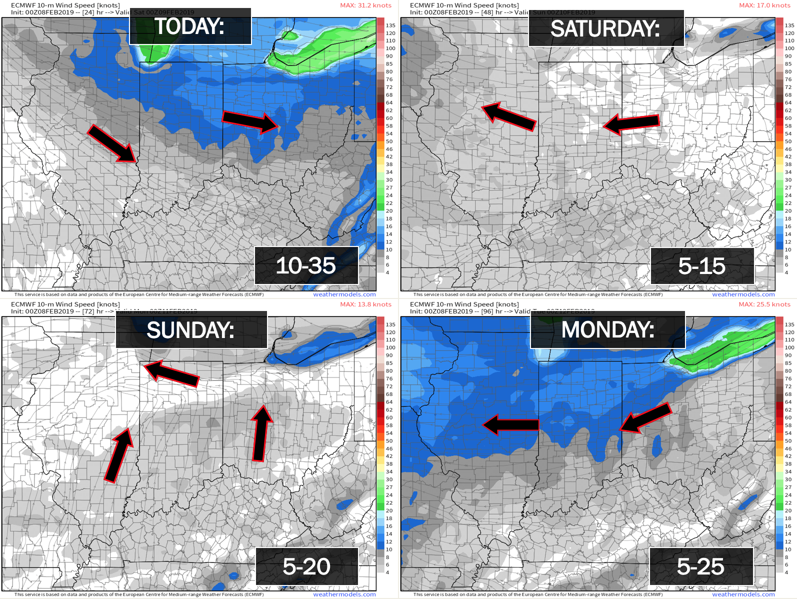

Friday and Saturday: Wintry precipitation is not anticipated.
Saturday night into Sunday night: A light wintry mix is possible late Saturday night over southeast Missouri. Whether it moves further northeast is questionable.
Early Sunday morning portions of the region may still be below freezing before temperatures rise into the 40’s. Any precip that falls before temperatures rise would fall as a wintry mix.
Roads will be cold. We will need to monitor the potential of a few icy patches.
Everything changes to rain by Sunday afternoon.
Temperatures may fall enough Monday night for a brief period of a wintry mix or snow across northern portions of southeast Missouri and portions of southern Illinois. Rain, elsewhere.
Monday through Wednesday: Wintry precipitation is not anticipated.
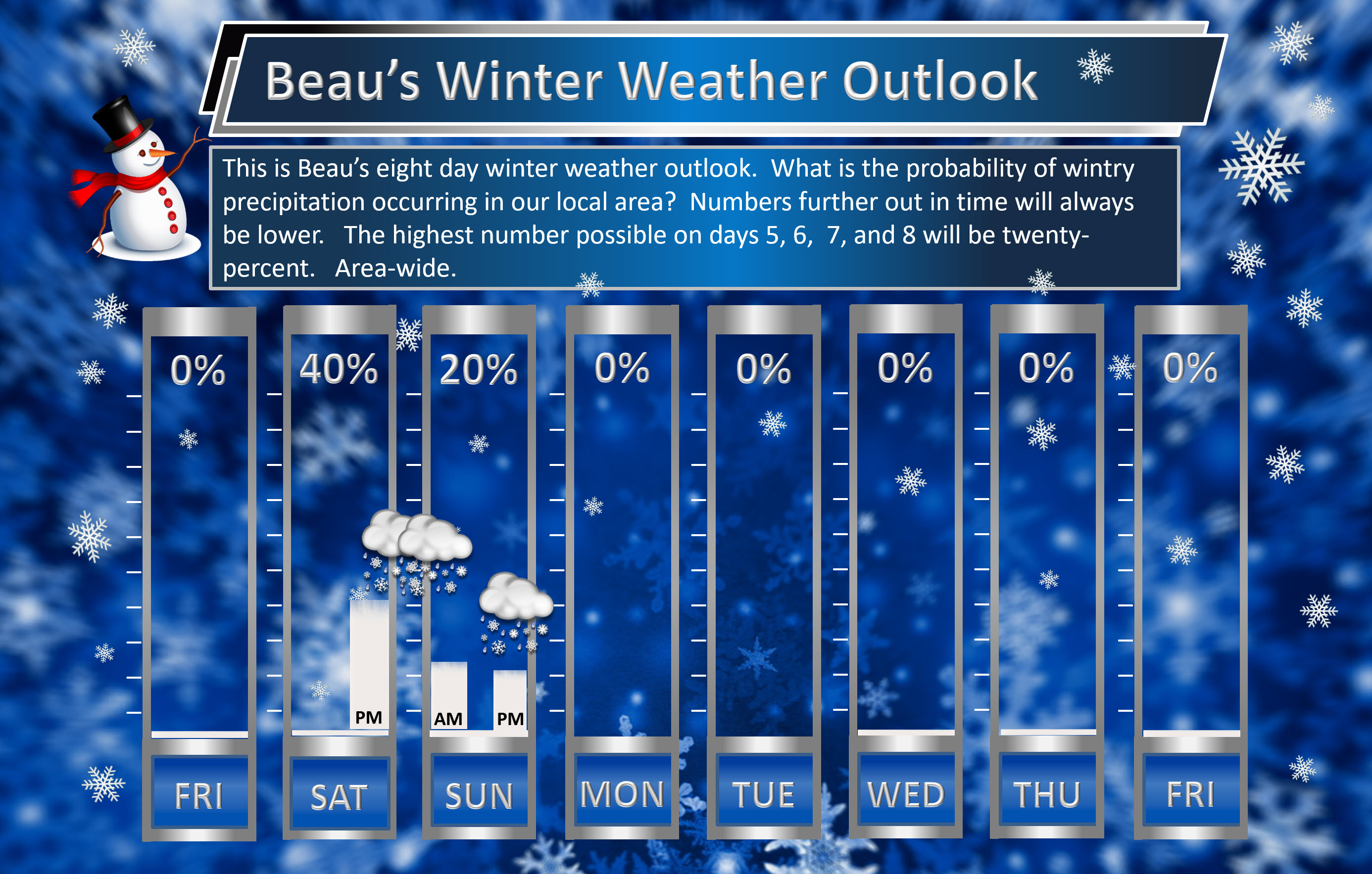
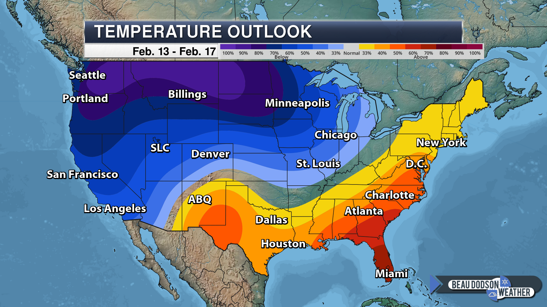
Beau’s exclusive eight-day winter weather outlook!
The highest number possible on days 5, 6, 7, and 8 will be twenty-percent.
Daily outlook:

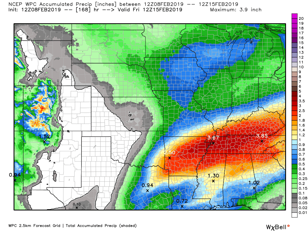
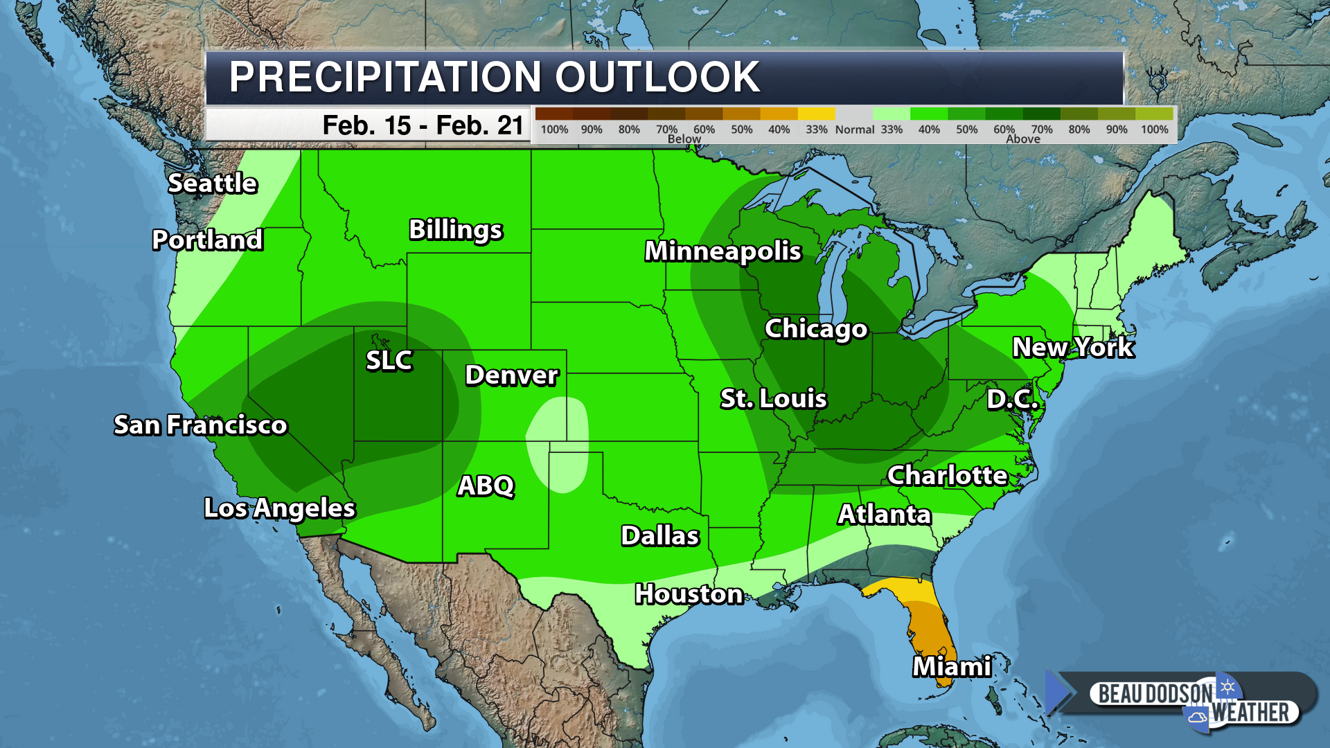
Here is the latest graphic from the WPC/NOAA.
This map shows you liquid and does not assume precipitation type. In other words, melted precipitation totals.
Most of this will fall on Sunday night into Monday night. Locally heavy is again possible.
Subscribers, do you need a forecast for an outdoor event?

Did you know that you can find me on Twitter?


Click here for your interactive local city-view radars & regional radars.
During winter weather be sure and click the winterize button above each city-view radar. This will show you the precipitation type.

The National Weather Service defines a severe thunderstorm as one that produces quarter size hail or larger, 58 mph winds or greater, and/or a tornado.
Friday through Thursday: No severe weather concerns.
Interactive live weather radar page. Choose the city nearest your location. If one of the cities does not work then try a nearby one. Click here.
National map of weather watches and warnings. Click here.
Storm Prediction Center. Click here.
Weather Prediction Center. Click here.

Live lightning data: Click here.

Interactive GOES R satellite. Track clouds. Click here.

Here are the latest local river stage forecast numbers Click Here.
Here are the latest lake stage forecast numbers for Kentucky Lake and Lake Barkley Click Here.

- Much colder today into Saturday.
- Wintry mix late Saturday night and Sunday morning (for some)
- Another big rain event unfolding.
- River flooding.
Changes over the last 24 hours.
No major changes in today’s forecast through Sunday night.
Dramatic changes in the Monday through Wednesday forecast. Complete flip concerning precipitation chances Tuesday and Wednesday.
Confidence in the forecast
Confidence in the forecast today through Wednesday is medium.
Action?
Monitor updated river flood forecast numbers. Sharp rises on area rivers are likely.
Monitor road conditions late Saturday night into Sunday morning as some light precipitation develops. A few icy spots can’t be ruled out.
Forecast Analysis and Numerical Model Guidance
Today is a travel day for me.
We had a bumpy 24 hours. Damaging wind and possibly even a few isolated tornadoes hit the area yesterday. The greatest number of severe weather reports were from southeast Missouri. A few reports elsewhere.
A train was even blown over in Dexter, Missouri. Wind speeds likely topped 70 mph in some areas.
That is all behind us now.
The big story over the next 24 to 48 hours will be the dramatic shift to cold weather.
Portions of the region were in the 70’s the last couple of days. This morning much of the region was in the teens and lower 20’s with wind chill values in the single digits.
The cold will last into Saturday.
As a matter of fact, our coldest night will be tonight. Widespread low to mid-teens.
Our next precipitation maker arrives late Saturday night into Monday night.
It may be cold enough late Saturday night for a light wintry mix to develop. Roads will be cold. Whatever falls would stick.
The amounts should not be all that great. With cold roads, however, I can’t rule out icy patches.
Monitor radars and my updates.
The light wintry mix will change to all rain by Sunday late morning into the afternoon as temperatures rise above freezing.
Any accumulation Sunday morning would be light. Again, however, with cold roads, there could be a few icy spots.
Rain chances will continue into Monday night.
Locally heavy rain is possible Monday/Monday night as yet another cold front pushes across the region.
I have removed precipitation chances from the Tuesday and Wednesday forecast. Remember, at one time that was a rain or snow event. Models have been horrible in the medium to long range. Be sure and pay attention to my confidence levels in the daily forecast numbers. That gives you a decent idea of what I am anticipating as far as potential changes in the forecast. A low confidence rating would mean that changes in the forecast numbers will likely occur.
Severe weather does not appear to be a concern Monday or Monday night. That is some good news.
Let’s take a look at the NAM model future-cast radar.
This takes us from Saturday night into Monday.
Green is rain. Blue is snow. Pink and red would be a mix.
Timestamp upper left
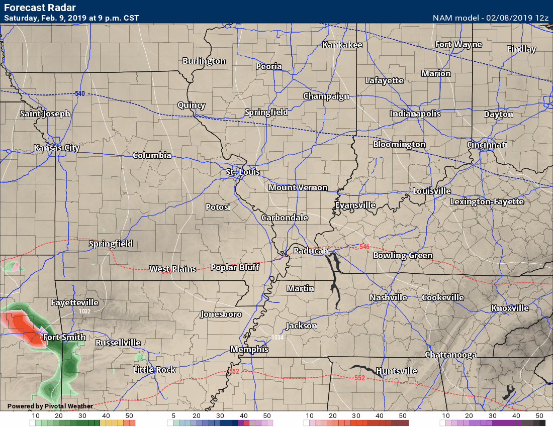
Rain should come to an end by Tuesday morning.
Monitor river stages. Large rises are anticipated over the coming days.
Highs today
Lows tonight
Highs tomorrow
Lows tomorrow night

See our local city-view radars for live data. Click here for your interactive local city-view radars & regional radars.
Satellite
Today’s image is the IR satellite. You can see thick clouds over our region.
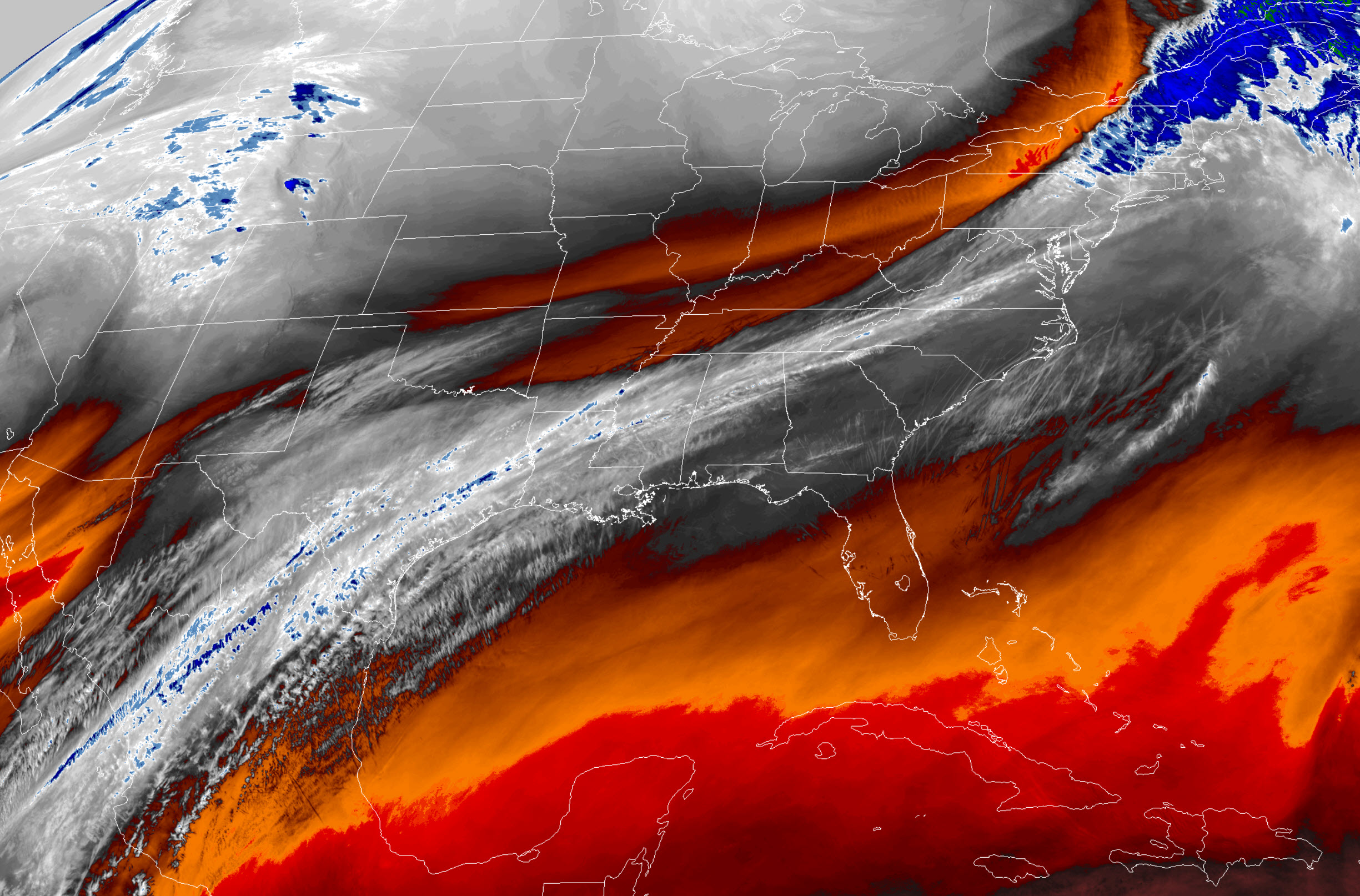
Interactive GOES R satellite. Track clouds. Click here.
Here is the latest WPC 6 to 10 and 8 to 14-day temperature outlooks.
** NOTE: See our own in-house long-range forecast graphics further down in this blog update **
Days 6 through 10
The blue colors indicate below normal temperatures. The darker the blue the greater the chance of below normal temperatures.
Temperature
Precipitation outlook

Days 8 through 14

Precipitation
SPRING OUTLOOK
Outlook definitions
EC = Equal chances of above or below normal
BN= Below normal
M/BN = Much below normal
AN = Above normal
M/AN = Much above normal
E/AN = Extremely above normal
March temperature and precipitation outlook
This product is for subscribers.
Subscribe at www.weathertalk.com
April temperature and precipitation outlook
This product is for subscribers.
Subscribe at www.weathertalk.com
May temperature and precipitation outlook
This product is for subscribers.
Subscribe at www.weathertalk.com
Here is the preliminary March, April, and May temperature and precipitation forecast.
Temperature outlook
This product is for subscribers.
Subscribe at www.weathertalk.com
Precipitation outlook
This product is for subscribers.
Subscribe at www.weathertalk.com
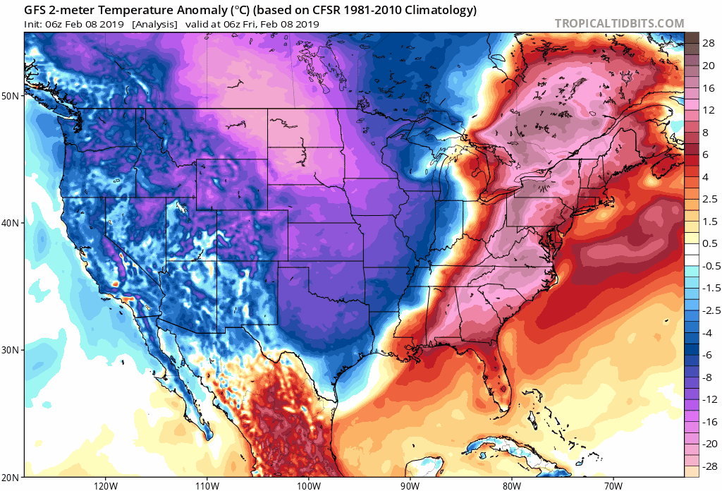
Long Range Temperature Anomaly Forecast
Let’s look at the temperature anomaly forecast map from the long-range GFS model guidance.
This graphic shows you whether temperatures are forecast to average above or below normal.
Red shades indicate above normal temperatures. Orange and red indicate much above normal temperatures.
Blue shades represent below normal temperatures. Purple to pinkish represents much below normal temperatures.
The time-stamp is located in the upper left portion of the map animation.
Click the image to enlarge it.
![]()
VIDEO UPDATES
This product is for subscribers.
Subscribe at www.weathertalk.com
The February update has been posted. Temperature forecast from the long-range team.
This product is for subscribers.
Subscribe at www.weathertalk.com
SPRING OUTLOOK
Here is the preliminary March, April, and May temperature and precipitation forecast.
Temperature and precipitation outlooks
This product is for subscribers.
Subscribe at www.weathertalk.com
Long Range Temperature Anomaly Forecast
This product is for subscribers.
Subscribe at www.weathertalk.com
![]()

I bring these to you from the BAMwx team. They are excellent long-range forecasters.
Remember, long-range outlooks are a bit of skill, understanding weather patterns, and luck combined. It is not an exact science.

This product is for subscribers.
Subscribe at www.weathertalk.com
Subscriber graphics can be viewed on this page CLICK HERE

This product is for subscribers.

This product is for subscribers.
Subscribe at www.weathertalk.com
Subscriber graphics can be viewed on this page CLICK HERE
![]()
.
![]()

A new weather podcast is now available! Weather Geeks (which you might remember is on The Weather Channel each Sunday)
To learn more visit their website. Click here.
![]()

WeatherBrains Episode 681
First joining us tonight is Leslie Chapman-Henderson, CEO of FLASH (Federal Alliance for Safe Homes), to congratulate our very own James Spann on winning the 2019 National Weather Person of the Year award. Leslie, thanks for joining us!
Tonight’s Guest WeatherBrain is a retired National Weather Service WCM for Little Rock, Arkansas. After many years of service, he retired in 2015. John Robinson, welcome to the show!
Also joining us as Guest Panelist is is the Field Meteorologist and Executive Weather Producer for KOCO 5 First Alert Weather. Mike Armstrong, welcome!
Discussions in this weekly podcast include topics like:
- James wins WeatherPerson of the Weather 2019
- American Airlines Flight 1420 crash of 1999
- 1999 Arkansas tornado outbreak
- Correlations between tornado fatalities and socioeconomic status?
- The Astronomy Report from Tony Rice
- and more!
Find me on Facebook!

Find me on Twitter!

Did you know that a portion of your monthly subscription helps support local charity projects?
You can learn more about those projects by visiting the Shadow Angel Foundation website and the Beau Dodson News website.


We offer interactive local city live radars and regional radars. If a radar does not update then try another one. If a radar does not appear to be refreshing then hit Ctrl F5. You may also try restarting your browser.
The local city view radars also have clickable warnings.
During the winter months, you can track snow and ice by clicking the winterize button on the local city view interactive radars.
You may email me at beaudodson@usawx.com
Find me on Facebook!
Find me on Twitter!
Did you know that a portion of your monthly subscription helps support local charity projects?
You can learn more about those projects by visiting the Shadow Angel Foundation website and the Beau Dodson News website.
I encourage subscribers to use the app vs regular text messaging. We have found text messaging to be delayed during severe weather. The app typically will receive the messages instantly. I recommend people have three to four methods of receiving their severe weather information.
Remember, my app and text alerts are hand typed and not computer generated. You are being given personal attention during significant weather events.
