LONG RANGE OUTLOOKS/Videos/Graphics
A general spring and summer outlook has been posted. More details will be posted over time.
Bonus maps and videos have been updated.
Link to the long range outlooks (Scroll down to the 2nd post at this link for the latest long range outlook) and videos (for subscribers) – Click here
You haven’t subscribed? Subscribe at www.beaudodsonweather.com
Monthly operating costs for Weather Talk can top $2000.00. Your $3 subscription helps pay for those costs. I work for you.
.

.
February 7, 2018
Wednesday Forecast Details
Forecast: Quite a few clouds. Clearing as the day wears on. Clearing from the west. Cold with gusty winds.
Temperatures: MO ~ 30 to 35 IL ~ 30 to 35 KY ~ 33 to 36
What is the chance of precipitation? MO ~ 0% IL ~ 0% KY ~ 0% TN ~ 0%
Coverage of precipitation: Ending
Wind chill values: 15 to 30
Accumulating snow or ice: No new precipitation
What impacts are anticipated from the weather? Monitor for icy road conditions across portions of the region
My confidence in the forecast verifying: High
Is severe weather expected? No
The NWS defines severe weather as 58 mph wind or great, 1″ hail or larger, and/or tornadoes
Should I cancel my outdoor plans? No
.
Wednesday Night Forecast Details:
Forecast: Mostly clear. Chilly.
Temperatures: MO ~ 16 to 22 IL ~ 16 to 22 KY ~ 18 to 22
What is the chance of precipitation? MO ~ 0% IL ~ 0% KY ~ 0% TN ~ 0%
Coverage of precipitation: None
Wind chill values: 12 to 20
Accumulating snow or ice: No
Winds: North and northeast at 5 to 10 mph with gusts to 15 mph
What impacts are anticipated from the weather? None
My confidence in the forecast verifying: High
Is severe weather expected? No
The NWS defines severe weather as 58 mph wind or great, 1″ hail or larger, and/or tornadoes
Should I cancel my outdoor plans: No
.
February 8, 2018
Thursday Forecast Details
Forecast: Mostly sunny. A few passing clouds.
Temperatures: MO ~ 40 to 45 IL ~ 40 to 45 KY ~ 40 to 45
What is the chance of precipitation? MO ~ 0% IL ~ 0% KY ~ 0% TN ~ 0%
Coverage of precipitation: None
Wind chill values: 30 to 40
Accumulating snow or ice: No
Winds: Winds becoming southeast and south.
What impacts are anticipated from the weather? None
My confidence in the forecast verifying: High
Is severe weather expected? No
The NWS defines severe weather as 58 mph wind or great, 1″ hail or larger, and/or tornadoes
Should I cancel my outdoor plans? No
.
Thursday Night Forecast Details:
Forecast: Mostly clear. Chilly.
Temperatures: MO ~ 25 to 30 IL ~ 25 to 30 KY ~ 25 to 30
What is the chance of precipitation? MO ~ 0% IL ~ 0% KY ~ 0% TN ~ 0%
Coverage of precipitation: None
Wind chill values: 20 to 30
Accumulating snow or ice: No
Winds: South at 5 to 10 mph. Winds may become gusty in the late afternoon.
What impacts are anticipated from the weather? None
My confidence in the forecast verifying: High
Is severe weather expected? No
The NWS defines severe weather as 58 mph wind or great, 1″ hail or larger, and/or tornadoes
Should I cancel my outdoor plans: No
.
February 9, 2018
Friday Forecast Details
Forecast: Partly cloudy.
Temperatures: MO ~ 50 to 54 IL ~ 50 to 54 KY ~ 50 to 54
What is the chance of precipitation? MO ~ 0% IL ~ 0% KY ~ 0% TN ~ 0%
Coverage of precipitation: None
Wind chill values: N/A
Accumulating snow or ice: No
Winds: South winds 8 to 16 mph with gusts above 20 mph
What impacts are anticipated from the weather? None
My confidence in the forecast verifying: High
Is severe weather expected? No
The NWS defines severe weather as 58 mph wind or great, 1″ hail or larger, and/or tornadoes
Should I cancel my outdoor plans? No
.
Friday Night Forecast Details:
Forecast: Increasing clouds. A chance of showers or wintry mix late. Windy.
Temperatures: MO ~ 32 to 35 IL ~ 32 to 35 KY ~ 32 to 35
What is the chance of precipitation? MO ~ 30% IL ~ 20% KY ~ 30% TN ~ 30%
Coverage of precipitation: Scattered
Wind chill values: 20 to 30
Accumulating snow or ice: Monitor updates
Winds: South at 8 to 16 mph with gusts to 30 mph
What impacts are anticipated from the weather? Monitor updates
My confidence in the forecast verifying: LOW
Is severe weather expected? No
The NWS defines severe weather as 58 mph wind or great, 1″ hail or larger, and/or tornadoes
Should I cancel my outdoor plans: Monitor updates.
.
February 10, 2018
Saturday Forecast Details
Forecast: Cloudy. A chance of rain showers. Rain showers may be mixed with freezing rain or sleet before 8 AM.
Temperatures: MO ~ 44 to 48 IL ~ 44 to 48 KY ~ 44 to 48
What is the chance of precipitation? MO ~ 40% IL ~ 40% KY ~ 40% TN ~ 40%
Coverage of precipitation: Scattered
Wind chill values: 30 to 40
Accumulating snow or ice: Monitor
Winds: East and northeast winds 5 to 10 mph with gusts to 20 mph
What impacts are anticipated from the weather? Wet roadways. Monitor the potential for icy roads before 8 AM. Low confidence.
My confidence in the forecast verifying: Medium
Is severe weather expected? No
The NWS defines severe weather as 58 mph wind or great, 1″ hail or larger, and/or tornadoes
Should I cancel my outdoor plans? Have a plan B and monitor updates
.
Saturday Night Forecast Details:
Forecast: Cloudy. A chance of rain showers or a wintry mix.
Temperatures: MO ~ 28 to 34 IL ~ 28 to 34 KY ~ 28 to 34
What is the chance of precipitation? MO ~ 40% IL ~ 40% KY ~ 40% TN ~ 40%
Coverage of precipitation: Scattered
Wind chill values: 20 to 30
Accumulating snow or ice: Monitor updates
Winds: North and northeast winds 6 to 12 mph with gusts to 16 mph
What impacts are anticipated from the weather? Wet roadways. Monitor for icy conditions, as well.
My confidence in the forecast verifying: LOW
Is severe weather expected? No
The NWS defines severe weather as 58 mph wind or great, 1″ hail or larger, and/or tornadoes
Should I cancel my outdoor plans: Have a plan B and monitor updates.
.
February 11, 2018
Sunday Forecast Details
Forecast: Cloudy. Colder. A chance of rain showers. A wintry mix possible.
Temperatures: MO ~ 32 to 36 IL ~ 32 to 36 KY ~ 32 to 36
What is the chance of precipitation? MO ~ 40% IL ~ 40% KY ~ 40% TN ~ 40%
Coverage of precipitation: Scattered
Wind chill values: 30 to 40
Accumulating snow or ice: Monitor
Winds: East and northeast winds 7 to 14 mph with gusts to 20 mph
What impacts are anticipated from the weather? Wet roadways. Monitor the potential for icy roads before 8 AM. Low confidence.
My confidence in the forecast verifying: Medium
Is severe weather expected? No
The NWS defines severe weather as 58 mph wind or great, 1″ hail or larger, and/or tornadoes
Should I cancel my outdoor plans? Have a plan B and monitor updates
.
Sunday Night Forecast Details:
Forecast: Clearing and colder.
Temperatures: MO ~ 18 to 24 IL ~ 18 to 24 KY ~ 18 to 24
What is the chance of precipitation? MO ~ 0% IL ~ 0% KY ~ 0% TN ~ 0%
Coverage of precipitation: Most likely none
Wind chill values: 15 to 20
Accumulating snow or ice: No
Winds: North and northeast winds 6 to 12 mph with gusts to 16 mph
What impacts are anticipated from the weather? None
My confidence in the forecast verifying: Medium
Is severe weather expected? No
The NWS defines severe weather as 58 mph wind or great, 1″ hail or larger, and/or tornadoes
Should I cancel my outdoor plans: No
.
February 12, 2018
Monday Forecast Details
Forecast: Mostly sunny. Cool.
Temperatures: MO ~ 42 to 46 IL ~ 42 to 46 KY ~ 42 to 46
What is the chance of precipitation? MO ~ 0% IL ~ 0% KY ~ 0% TN ~ 0%
Coverage of precipitation: None
Wind chill values: 35 to 45
Accumulating snow or ice: No
Winds: East and southeast winds 6 to 12 mph
What impacts are anticipated from the weather? None.
My confidence in the forecast verifying: Medium
Is severe weather expected? No
The NWS defines severe weather as 58 mph wind or great, 1″ hail or larger, and/or tornadoes
Should I cancel my outdoor plans? No
.
Monday Night Forecast Details:
Forecast: Mostly clear. A few clouds.
Temperatures: MO ~ 30 to 35 IL ~ 30 to 35 KY ~ 30 to 35
What is the chance of precipitation? MO ~ 0% IL ~ 0% KY ~ 0% TN ~ 0%
Coverage of precipitation: None
Wind chill values: 25 to 30
Accumulating snow or ice: No
Winds: South and southeast winds 5 to 10 mph
What impacts are anticipated from the weather? None
My confidence in the forecast verifying: Medium
Is severe weather expected? No
The NWS defines severe weather as 58 mph wind or great, 1″ hail or larger, and/or tornadoes
Should I cancel my outdoor plans: No
Interactive Weather Radar Page. Choose the city nearest your location: Click this link.
.

.
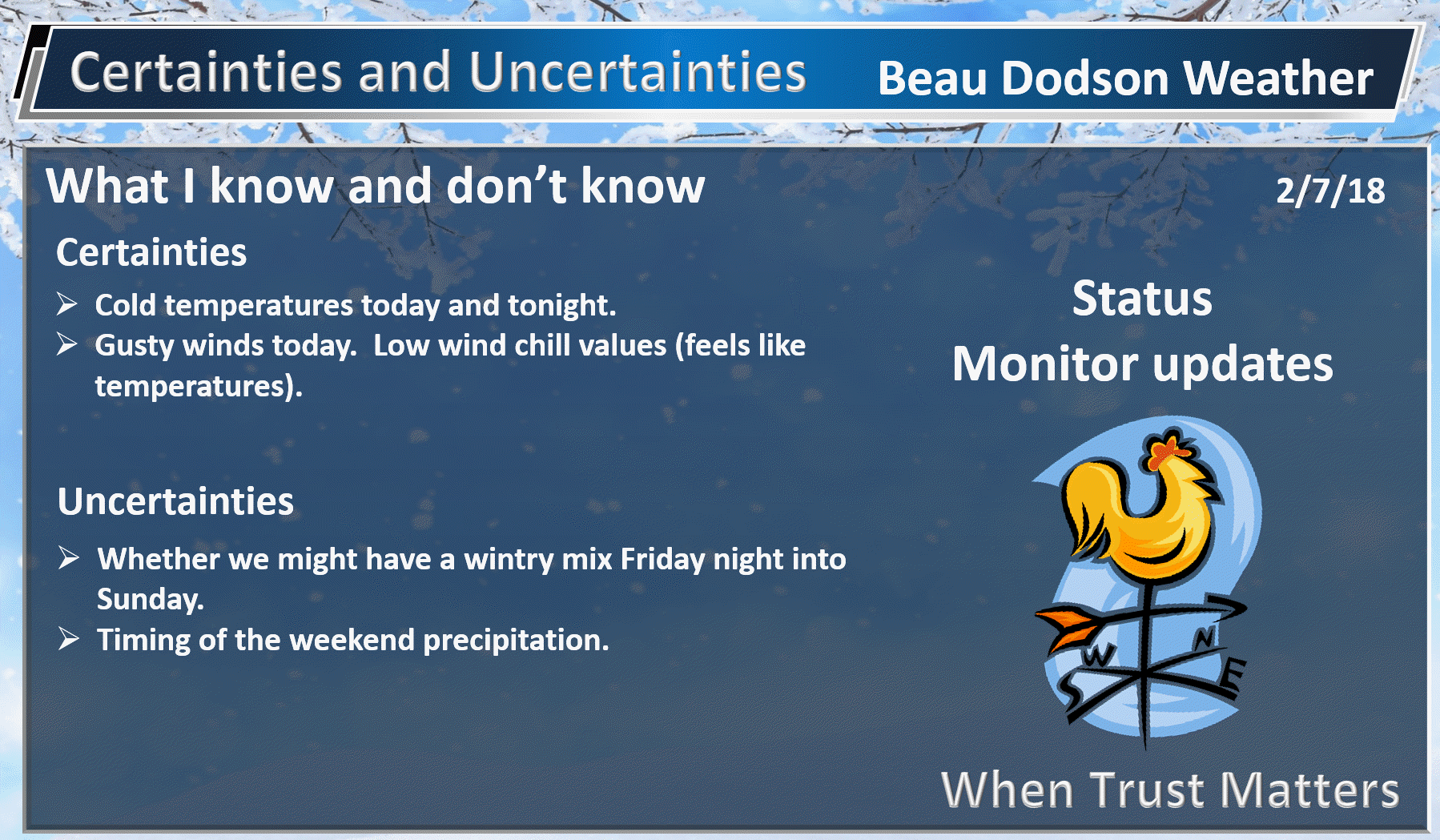
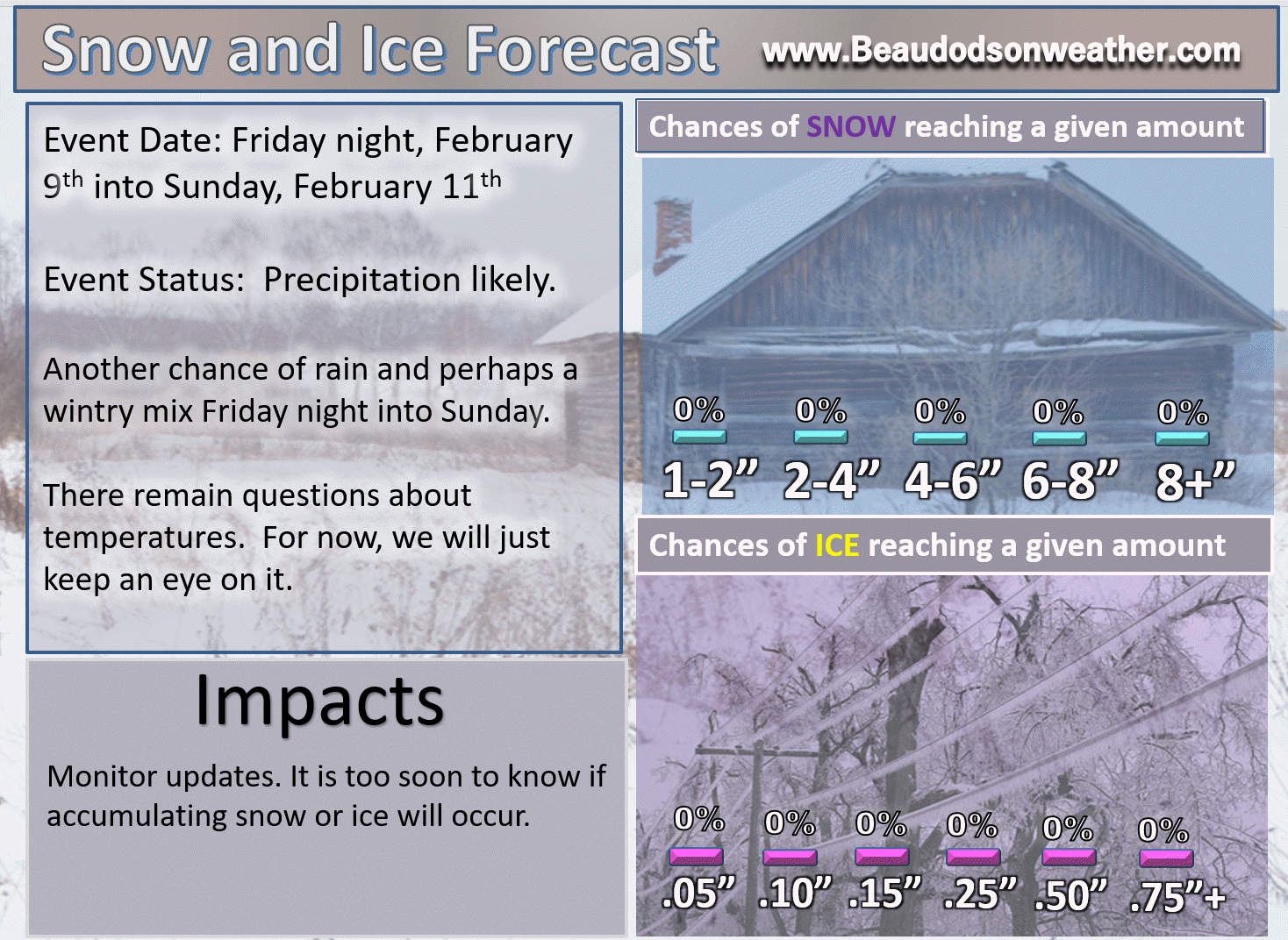
Wednesday into Friday: Winter weather is not anticipated. It will be cold. Watch for remaining slick spots from Tuesday’s precipitation event.
Friday night into Sunday: A wintry mix is possible. Monitor updates.
.

.
The National Weather Service definition of a severe thunderstorm is one that produces quarter size hail or larger, 58 mph winds or greater, and/or a tornado.
Now through Tuesday: Severe weather is not in the forecast.
.

.
.
.
What may look wet could actually be ice. Black ice. Black ice looks like wet payment.
.

.
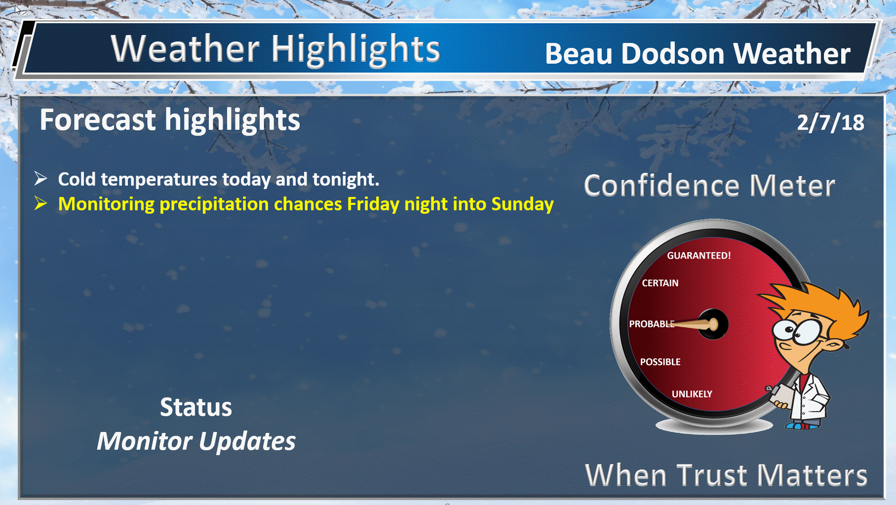
Forecast:
HIGHLIGHTS
- Quiet weather through Friday afternoon
- Rain chances increase Friday night and may linger into Sunday
- There is a chance of mixed precipitation this weekend, but confidence remains low
High confidence Wednesday night through Friday.
Monitor updates.
Friday night into Sunday (February 9th through the 11th)
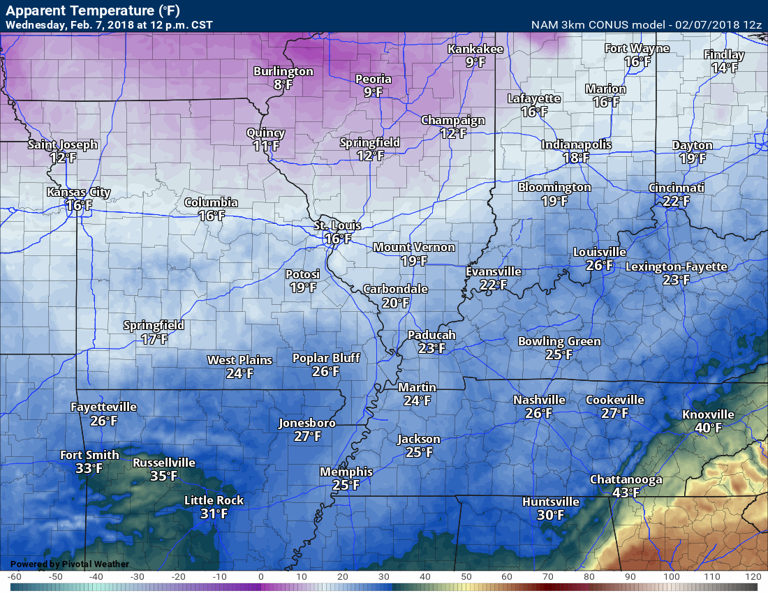
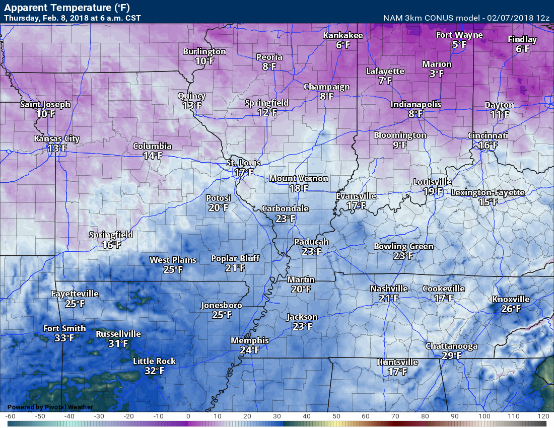
The main weather story today and tonight will be the cold temperatures. Highs today only topping out in the 30’s. Lows tonight in the teens to lower twenties. Combine that with winds and you have single digit wind chill values. That is what it feels like to the human skin.
.
Noon wind chill values
.
.
6 AM Thursday wind chill values
.
.
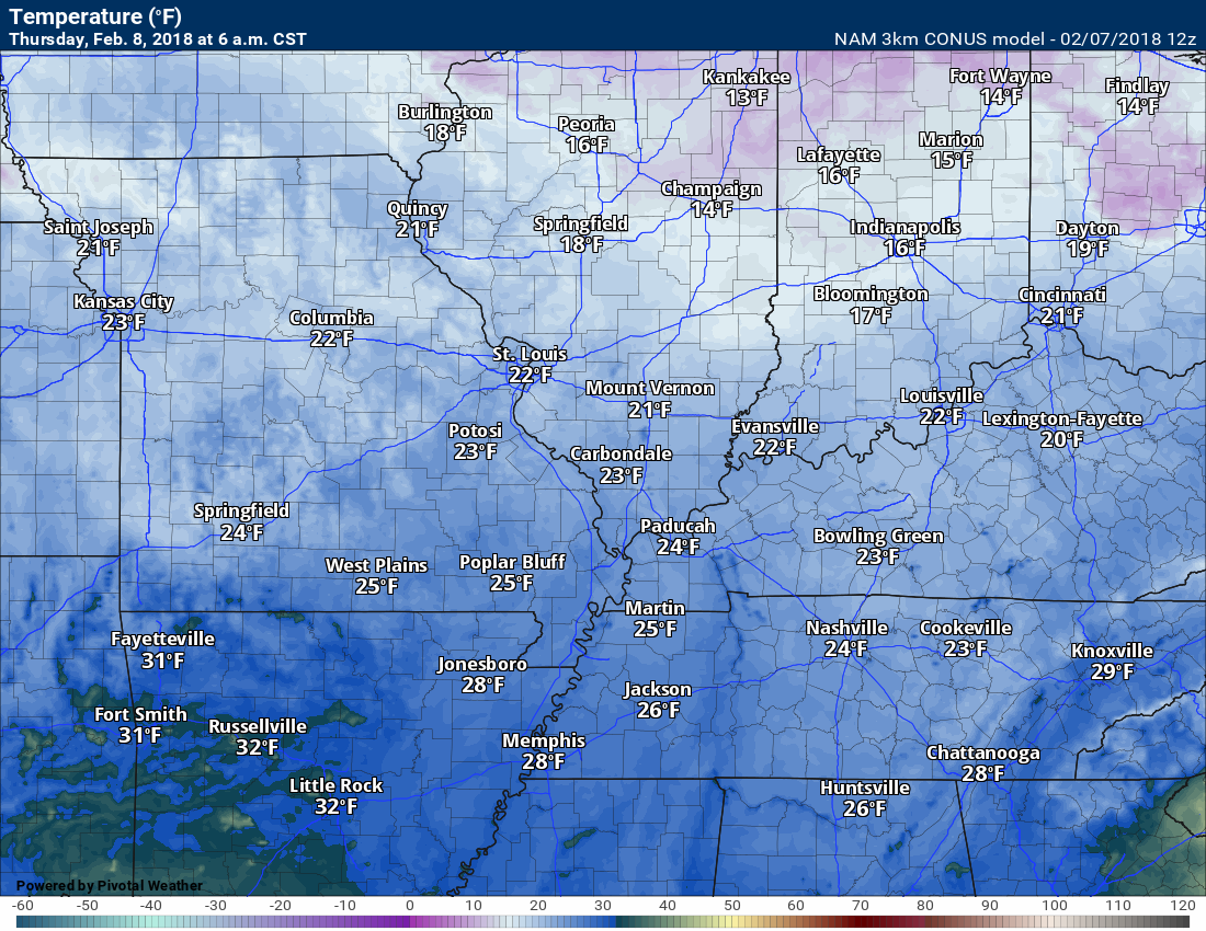
Lows tonight will dip into the teens and twenties. This is the NAM temperature forecast. It might actually be a bit colder than this.
.
.
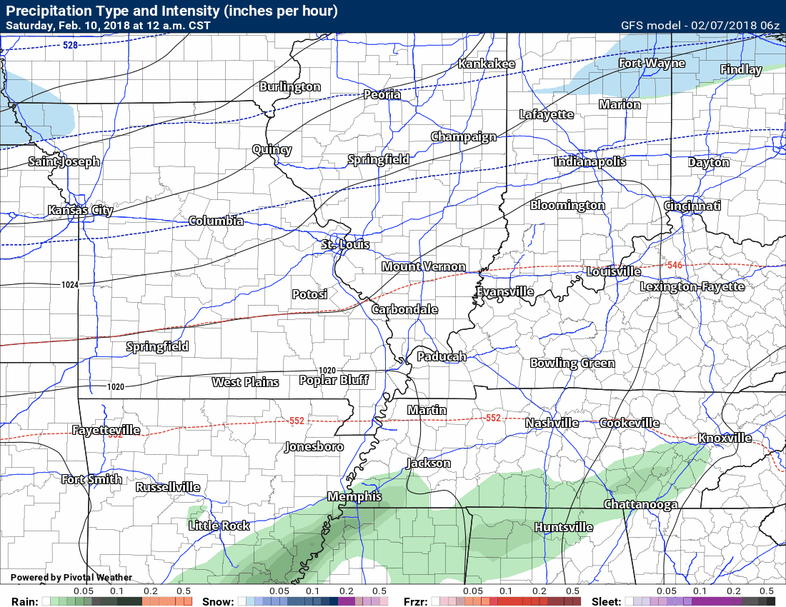
Here is the future-cast radar loop for the weekend system. Subject to changes. It is a bit early for details.
Time stamp upper left.
Green is rain. Blue is snow. Pink would be freezing rain and sleet.
.
.
I will initiate a graphic on next weekends system. Still early to know the details on this one.
.
.


We offer regional radars and local city radars – if a radar does not update then try another one. Occasional browsers need their cache cleared. You may also try restarting your browser. This will usually fix any problems.
During the winter you can track snow and ice by clicking the winterize button on the local city view interactive radars.
You may email me at beaudodson@usawx.com
Interactive Weather Radar Page. Choose the city nearest your location: Click this link
National interactive radar: Click this link.