LONG RANGE OUTLOOKS/Videos/Graphics
February and March outlooks have been updated.
Bonus maps and videos have been updated.
Link to the long range outlooks (Scroll down to the 2nd post at this link for the latest long range outlook) and videos (for subscribers) – Click here
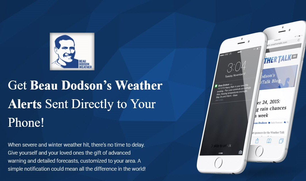
Subscribe at www.beaudodsonweather.com
Monthly costs to run Weather Talk can top $2000.00
Please consider subscribing!
Here are my monthly out of pocket costs to deliver you the weather.
.

.
Do you want more? How about short and long range outlooks, videos, and more detailed analysis!
Subscribe at www.beaudodsonweather.com
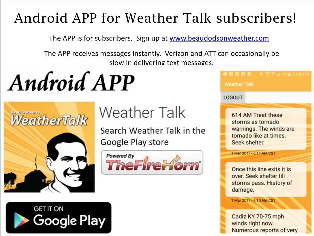
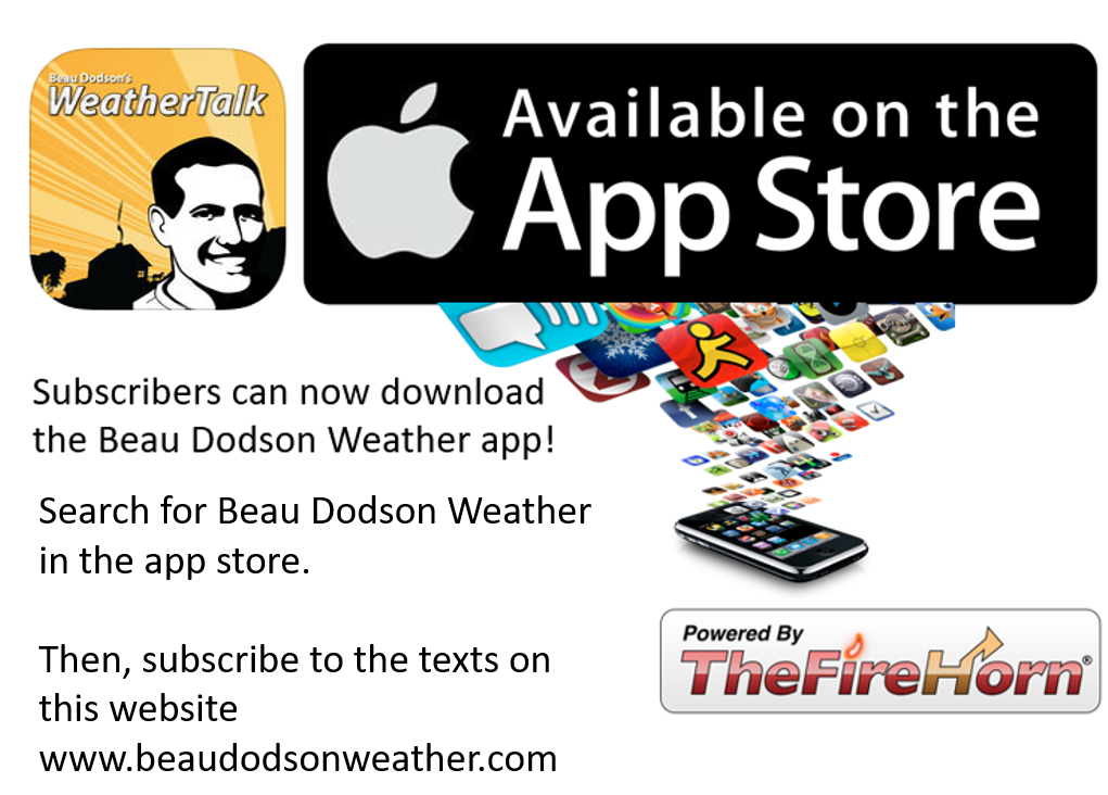
Once subscribed you can choose from four different app/text messages!
.
.
Be sure and download the app (subscribers). The app receives the messages much faster than regular text messaging (same messages, but faster).
.
.

.
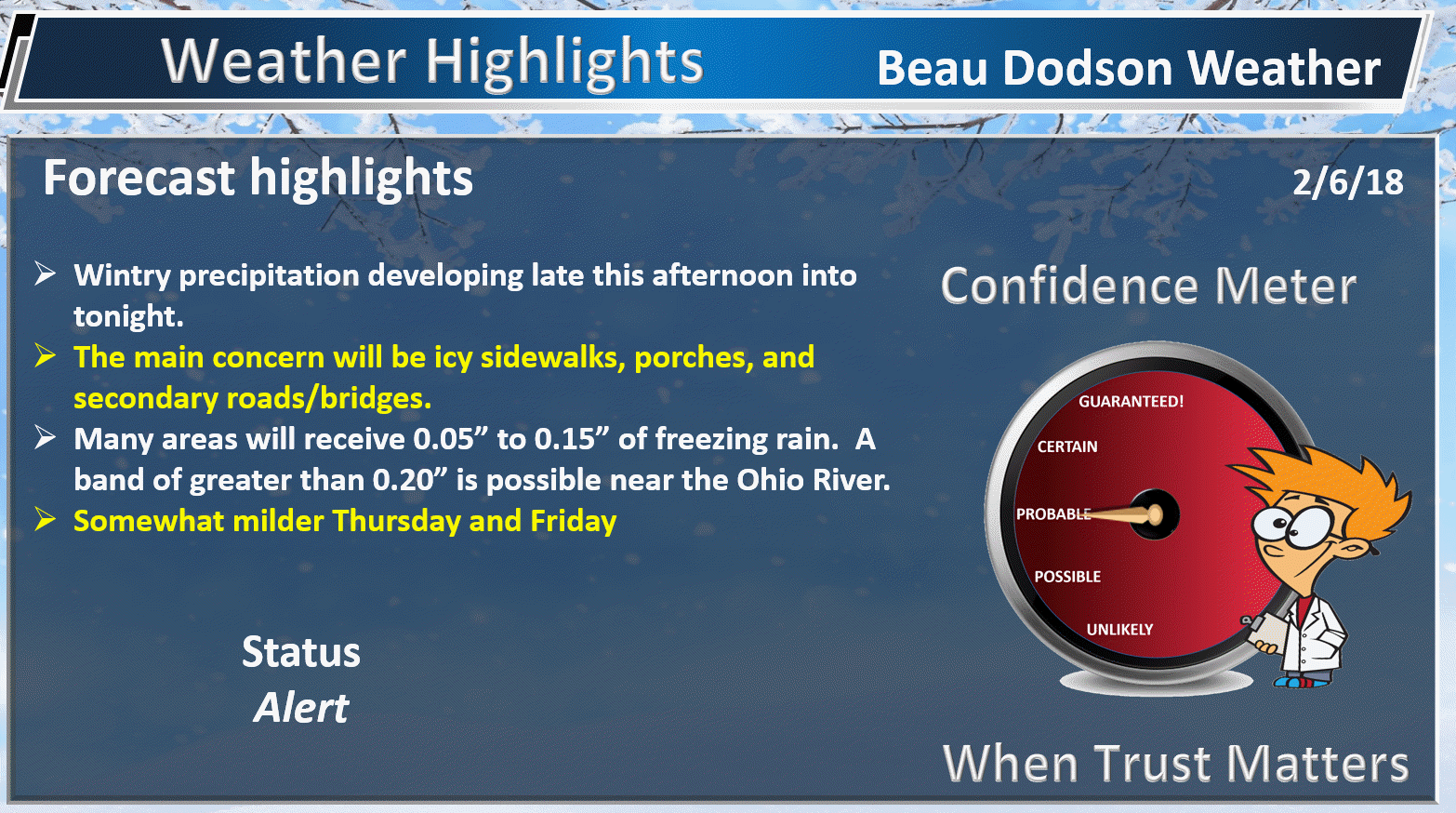
February 6, 2018
Tuesday Forecast Details
Forecast: Cloudy. A chance of freezing rain, snow, and rain across southeast Missouri and northwest Tennessee after 3 PM. Chances will increase area-wide towards the evening hours. Monitor updates. Most of the day will be dry.
Temperatures: MO ~ 32 to 44 IL ~ 32 to 44 KY ~ 35 to 40
What is the chance of precipitation? MO ~ 60% late IL ~ 30% late KY ~ 40% late TN ~ 60% late
Coverage of precipitation: Increasing coverage as we move into the late afternoon and evening hours.
Wind chill values: 24 to 32
Accumulating snow or ice: Monitor updates. Some accumulation of snow and ice is possible late in the day and evening.
Winds: Northeast and east winds at 7 to 14 mph
What impacts are anticipated from the weather? Perhaps icy roads developing late in the day. More likely tonight.
My confidence in the forecast verifying: High
Is severe weather expected? No
The NWS defines severe weather as 58 mph wind or great, 1″ hail or larger, and/or tornadoes
Should I cancel my outdoor plans? Have a plan B during the afternoon and evening hours. Monitor radars as precipitation develops towards late afternoon and evening.
.
Tuesday Night Forecast Details:
Forecast: Cloudy. Freezing rain, sleet, snow, and rain likely. It appears that all types of precipitation will be possible in the region. This may be an all rain event near the Land Between the Lakes and then east/southeast of there. Murray may remain mostly rain and then ending as freezing rain. Once you move north of Perryville, MO towards Carmi, IL there could be a dusting to a couple inches of snow. This does not appear to be a big snow maker. Freezing rain will occur from Poplar Bluff, MO towards the southern seven counties of southern Illinois, much of western Kentucky near the Ohio River. As you move further and further south/southeast the odds of mostly rain increases. The main concern is impact. Icy decks, icy porches, icy sidewalks, icy parking lots, icy secondary roads. Treated roads may not be as bad. Watch that first temp. It may look wet, but be ice.
Temperatures: MO ~ 25 to 30 IL ~ 25 to 30 KY ~ 28 to 34
What is the chance of precipitation? MO ~ 70% IL ~ 70% KY ~ 80% TN ~ 90%
Coverage of precipitation: Numerous to widespread
Wind chill values: 20 to 30
Accumulating snow or ice: Yes. Some accumulation of ice and snow possible.
Winds: North and northeast winds at 6 to 12 mph with gusts to 15 mph
What impacts are anticipated from the weather? Icy roads possible. Monitor the ice potential for spotty power outages. There is a chance of heavier freezing rain totals in a thin band from near Sikeston towards Paducah and then towards Owensboro. The band should be thin. Perhaps ten miles wide. Tough to forecast that. I am just letting you know the potential for heavier totals of freezing rain does exist.
My confidence in the forecast verifying: Medium to high
Is severe weather expected? No
The NWS defines severe weather as 58 mph wind or great, 1″ hail or larger, and/or tornadoes
Should I cancel my outdoor plans: Have a plan B
.
February 7, 2018
Wednesday Forecast Details
Forecast: Morning clouds. Freezing rain, sleet, snow, and rain possible before 8 AM. Precipitation ending early. Cold.
Temperatures: MO ~ 30 to 35 IL ~ 30 to 35 KY ~ 33 to 36
What is the chance of precipitation? MO ~ 40% IL ~ 40% KY ~ 50% TN ~ 50%
Coverage of precipitation: Ending
Wind chill values: 20 to 30
Accumulating snow or ice: Snow and ice accumulation possible, but the bulk of the precipitation should be over around sunrise or shortly after.
Winds: North at 6 to 12 mph with gusts to 18 mph
What impacts are anticipated from the weather? Monitor for icy road conditions across portions of the region
My confidence in the forecast verifying: High
Is severe weather expected? No
The NWS defines severe weather as 58 mph wind or great, 1″ hail or larger, and/or tornadoes
Should I cancel my outdoor plans? Have a plan B (esp morning hours)
.
Wednesday Night Forecast Details:
Forecast: Mostly clear. Chilly.
Temperatures: MO ~ 16 to 22 IL ~ 16 to 22 KY ~ 18 to 22
What is the chance of precipitation? MO ~ 0% IL ~ 0% KY ~ 0% TN ~ 0%
Coverage of precipitation: None
Wind chill values: 12 to 20
Accumulating snow or ice: No
Winds: North and northeast at 5 to 10 mph with gusts to 15 mph
What impacts are anticipated from the weather? Icy roads may remain in some areas
My confidence in the forecast verifying: High
Is severe weather expected? No
The NWS defines severe weather as 58 mph wind or great, 1″ hail or larger, and/or tornadoes
Should I cancel my outdoor plans: No
.
February 8, 2018
Thursday Forecast Details
Forecast: Mostly sunny. A few passing clouds.
Temperatures: MO ~ 36 to 44 IL ~ 36 to 44 KY ~ 38 to 44
What is the chance of precipitation? MO ~ 0% IL ~ 0% KY ~ 0% TN ~ 0%
Coverage of precipitation: None
Wind chill values: 30 to 40
Accumulating snow or ice: No
Winds: East and southeast at 5 to 10 mph. Wind gusts to 15 mph possible. Winds variable in direction.
What impacts are anticipated from the weather? None
My confidence in the forecast verifying: High
Is severe weather expected? No
The NWS defines severe weather as 58 mph wind or great, 1″ hail or larger, and/or tornadoes
Should I cancel my outdoor plans? No
.
Thursday Night Forecast Details:
Forecast: Mostly clear. Chilly.
Temperatures: MO ~ 25 to 30 IL ~ 25 to 30 KY ~ 25 to 30
What is the chance of precipitation? MO ~ 0% IL ~ 0% KY ~ 0% TN ~ 0%
Coverage of precipitation: None
Wind chill values: 20 to 30
Accumulating snow or ice: No
Winds: Variable at 5 to 10 mph
What impacts are anticipated from the weather? None
My confidence in the forecast verifying: High
Is severe weather expected? No
The NWS defines severe weather as 58 mph wind or great, 1″ hail or larger, and/or tornadoes
Should I cancel my outdoor plans: No
.
February 9, 2018
Friday Forecast Details
Forecast: Partly cloudy.
Temperatures: MO ~ 45 to 50 IL ~ 45 to 50 KY ~ 45 to 50
What is the chance of precipitation? MO ~ 0% IL ~ 0% KY ~ 0% TN ~ 0%
Coverage of precipitation: None
Wind chill values: N/A
Accumulating snow or ice: No
Winds: East and southeast at 5 to 10 mph. Wind gusts to 15 mph possible. Winds variable in direction.
What impacts are anticipated from the weather? None
My confidence in the forecast verifying: High
Is severe weather expected? No
The NWS defines severe weather as 58 mph wind or great, 1″ hail or larger, and/or tornadoes
Should I cancel my outdoor plans? No
.
Friday Night Forecast Details:
Forecast: Increasing clouds. A 30% of snow showers or wintry mix late.
Temperatures: MO ~ 25 to 30 IL ~ 25 to 30 KY ~ 25 to 30
What is the chance of precipitation? MO ~ 30% IL ~ 30% KY ~ 30% TN ~ 30%
Coverage of precipitation: Scattered
Wind chill values: 20 to 30
Accumulating snow or ice: Perhaps
Winds: Northeast at 5 to 10 mph
What impacts are anticipated from the weather? Monitor updates
My confidence in the forecast verifying: LOW
Is severe weather expected? No
The NWS defines severe weather as 58 mph wind or great, 1″ hail or larger, and/or tornadoes
Should I cancel my outdoor plans: Monitor updates.
.
February 10, 2018
Saturday Forecast Details
Forecast: Cloudy. A chance for a wintry mix becoming rain.
Temperatures: MO ~ 36 to 44 IL ~ 36 to 44 KY ~ 38 to 44
What is the chance of precipitation? MO ~ 30% IL ~ 30% KY ~ 30% TN ~ 30%
Coverage of precipitation: Scattered
Wind chill values: 30 to 40
Accumulating snow or ice: Monitor
Winds:
What impacts are anticipated from the weather? Wet roadways. Monitor the potential for icy roads before 8 AM. Low confidence.
My confidence in the forecast verifying: LOW
Is severe weather expected? No
The NWS defines severe weather as 58 mph wind or great, 1″ hail or larger, and/or tornadoes
Should I cancel my outdoor plans? Have a plan B and monitor updates
.
Saturday Night Forecast Details:
Forecast: Cloudy. A chance for a few showers.
Temperatures: MO ~ 28 to 34 IL ~ 28 to 34 KY ~ 28 to 34
What is the chance of precipitation? MO ~ 30% IL ~ 30% KY ~ 30% TN ~ 30%
Coverage of precipitation: Scattered
Wind chill values: 20 to 30
Accumulating snow or ice: Monitor updates
Winds: Southeast at 6 to 12 mph
What impacts are anticipated from the weather? Wet roadways. Monitor for icy conditions, as well.
My confidence in the forecast verifying: LOW
Is severe weather expected? No
The NWS defines severe weather as 58 mph wind or great, 1″ hail or larger, and/or tornadoes
Should I cancel my outdoor plans: Have a plan B and monitor updates.
Interactive Weather Radar Page. Choose the city nearest your location: Click this link.
.

.
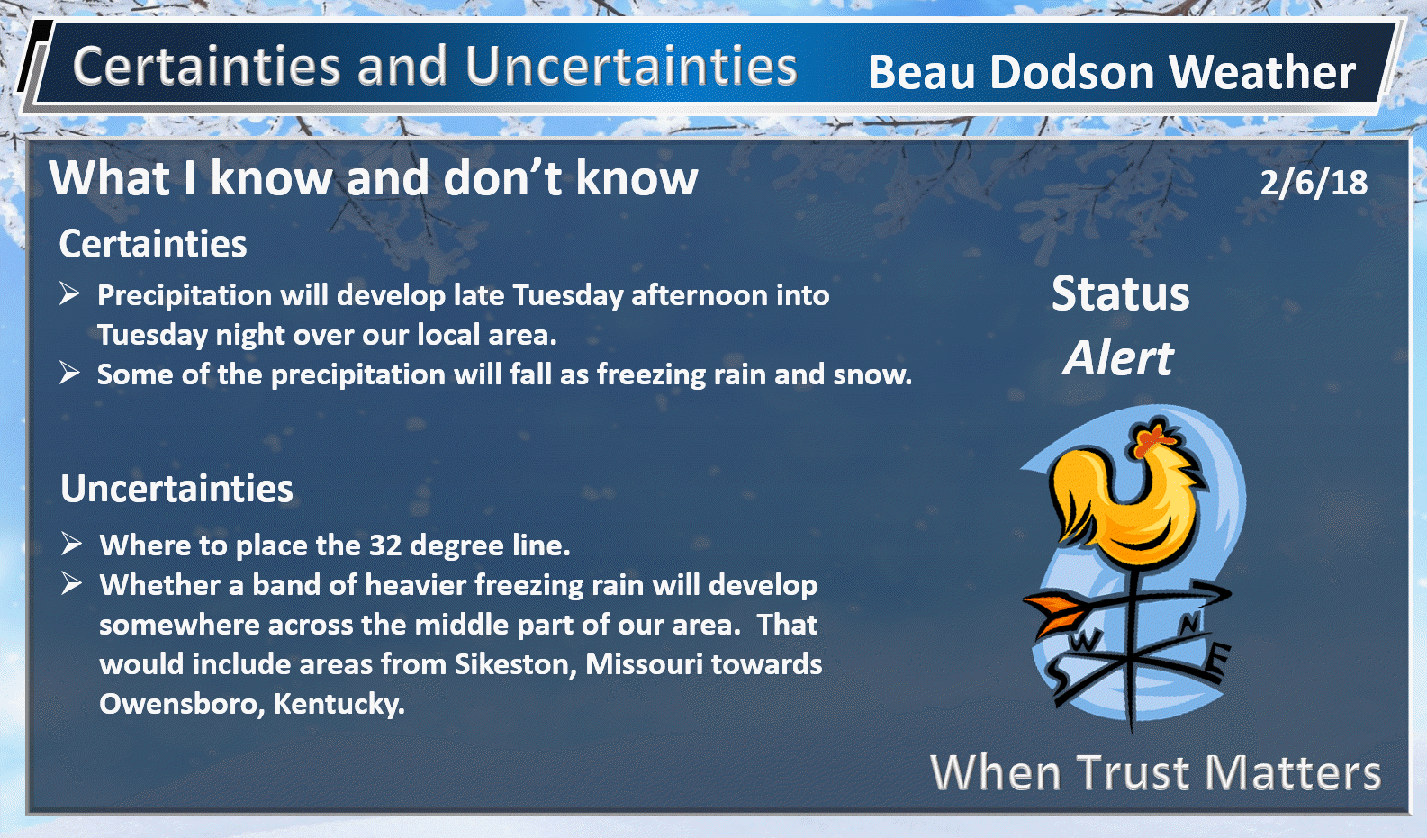
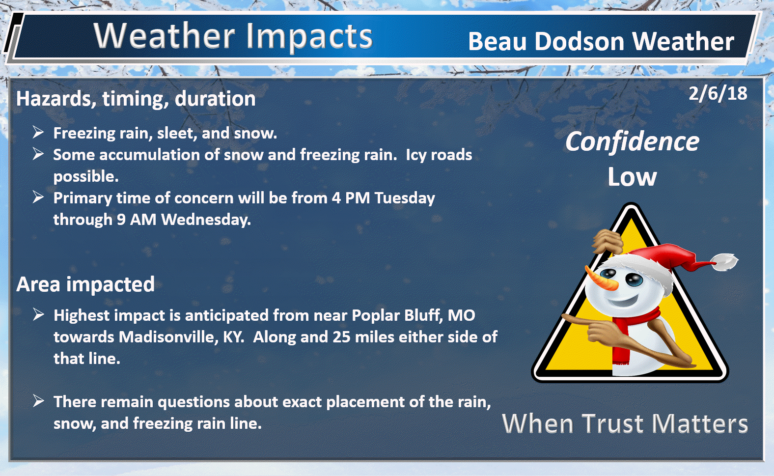
Tuesday afternoon into Wednesday morning: A winter storm is anticipated to deliver freezing rain, sleet, snow, and rain to the region. The track of the area of low pressure will be key to where the rain/ice/snow line sets up. Monitor updates concerning this winter storm.
.

.
The National Weather Service definition of a severe thunderstorm is one that produces quarter size hail or larger, 58 mph winds or greater, and/or a tornado.
Now through next Friday A few thunderstorms are possible Tuesday night. The best chance of lightning would be across the Missouri Bootheel and northwest Tennessee. This is highly dependent on the track of the area of low pressure and placement of the warm front. Monitor updates.
.

.
February 5, 2018
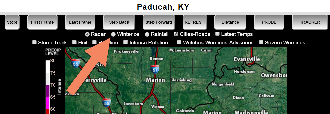
Interactive Weather Radar Page. Choose the city nearest your location: Click this link.
Click WINTERIZE on the local city view radars.
Example of the winterize button. This will show you rain vs snow vs ice. It is an algorithm, so it isn’t perfect.
.
.
.
.
.
.
.
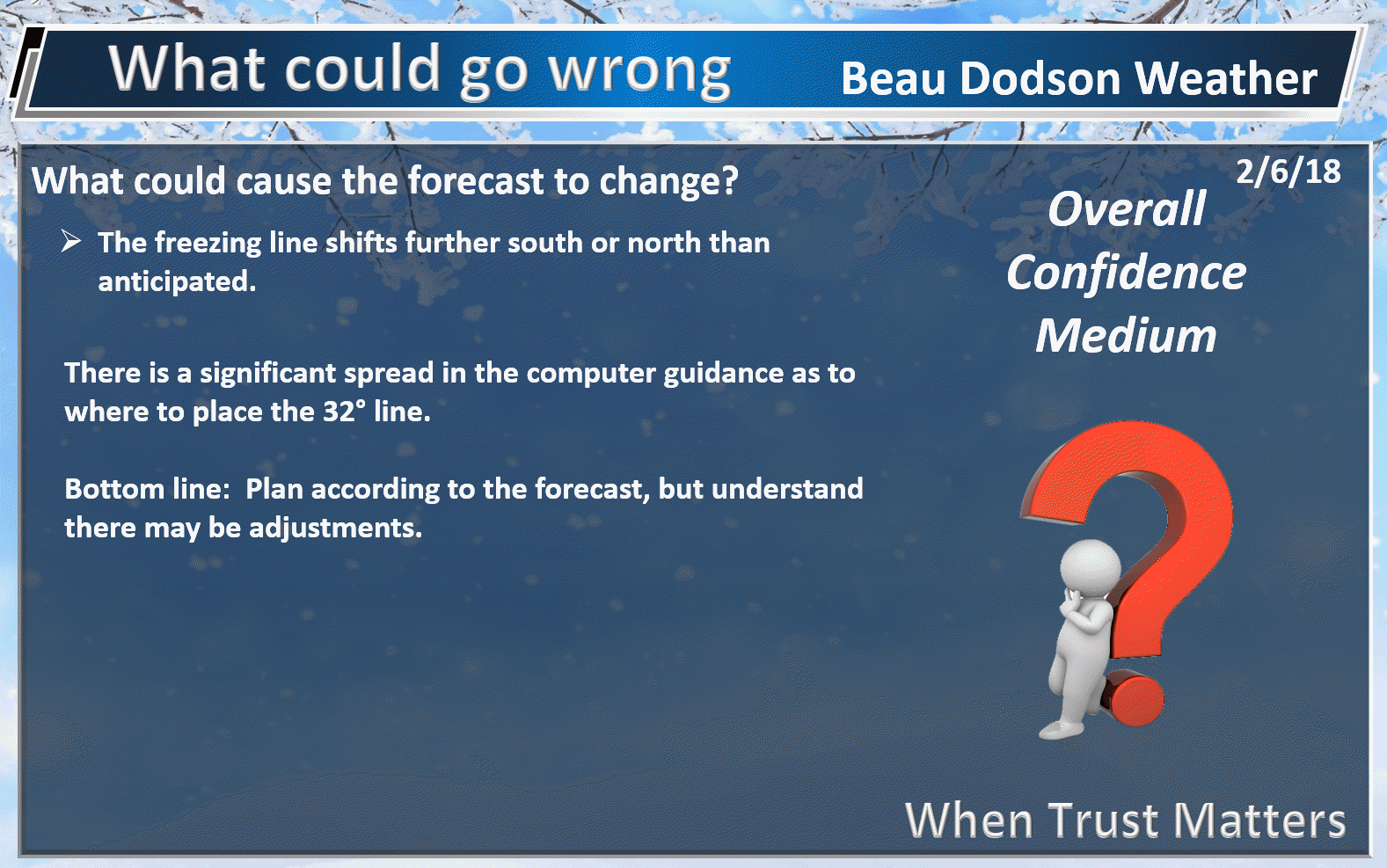
CAUTION: We could be off one county or so on the placement of the 32 degree line. This will change the forecast if we are off.
.
Watch that first step tonight/tomorrow. What may look wet could actually be ice. Black ice. Black ice looks like wet payment.

Join me on Facebook tonight to discuss the winter storm. www.facebook.com/beaudodsonweather
.
.
Forecast:
Winter Weather Radar
Be sure and turn on the winterize button above the local city view radars
Interactive Weather Radar Page. Choose the city nearest your location: Click this link.
Tuesday into Wednesday:
** Winter Storm **
** There remain questions about the placement of the 32 degree line **
HIGHLIGHTS
- Dry Tuesday morning.
- Freezing rain, sleet, snow, and rain develop late Tuesday afternoon and spread into our local area.
- Icy roads possible (for portions of the region) late Tuesday afternoon/evening into Wednesday morning.
- Some school closings possible Wednesday.
Medium confidence on the Tuesday through Wednesday forecast.
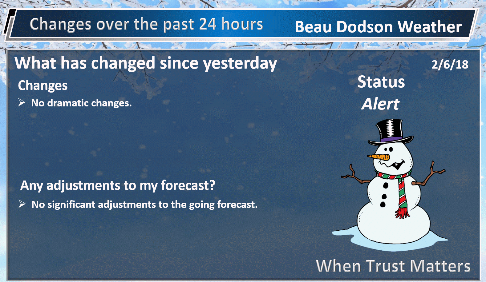
We have a complex weather forecast shaping up for later today into tonight.
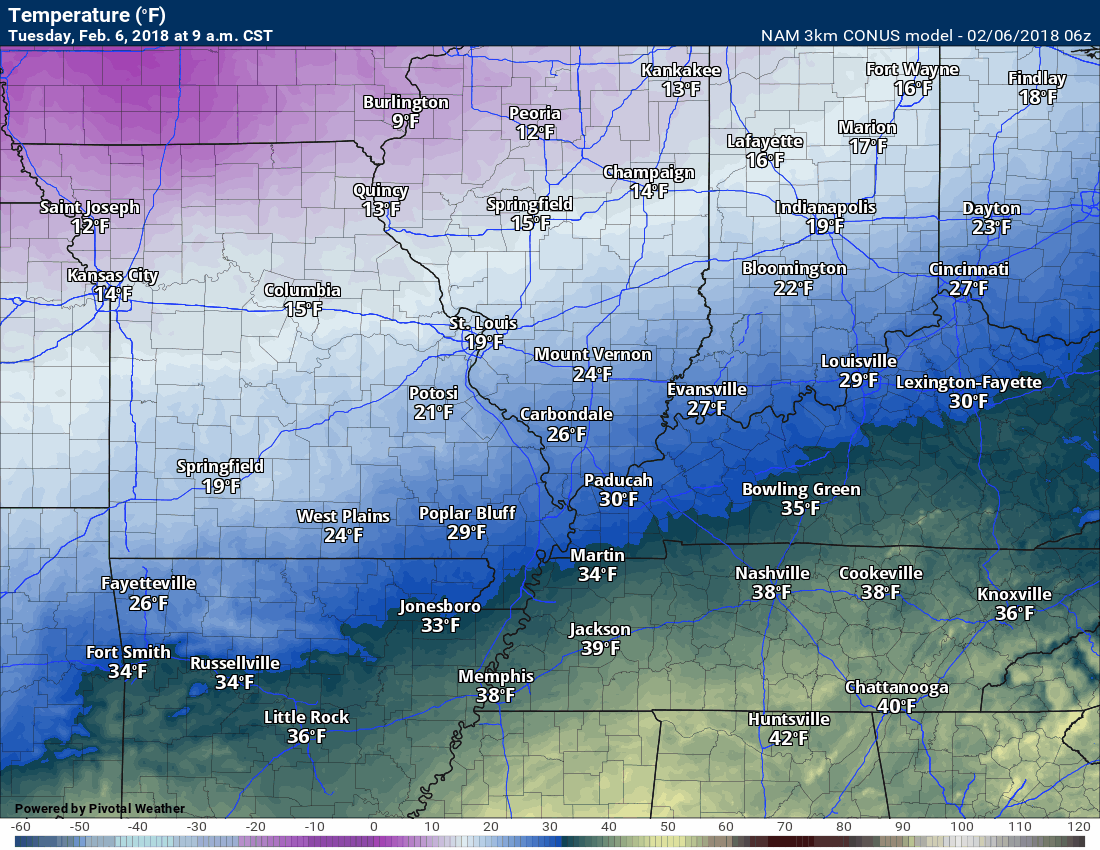
Temperatures today may not rise all that much. It will remain chilly.
A developing storm system to our southwest will spread moisture northward into the Missouri and Ohio/Tennessee Valley’s. The bulk of the rain/snow/ice will hit our area during the late Tuesday afternoon hours into the wee hours of Wednesday morning.
The best chance of frozen precipitation will extend along a line from Poplar Bluff, Missouri to Paducah, Kentucky, and then towards Owensboro, Kentucky. Along and that line should be near or below freezing.
There remain questions about how far south to shift the freezing line tonight into Wednesday morning. For now, the going forecast looks correct. Keep in mind, the precipitation may end as freezing rain over just about any county in the area. The amounts, however, in those ending last with freezing rain won’t be all that great (if any at all).
The margin of error in this forecast is likely one to two counties. Not a lot, but enough to significantly change the forecast for your backyard.
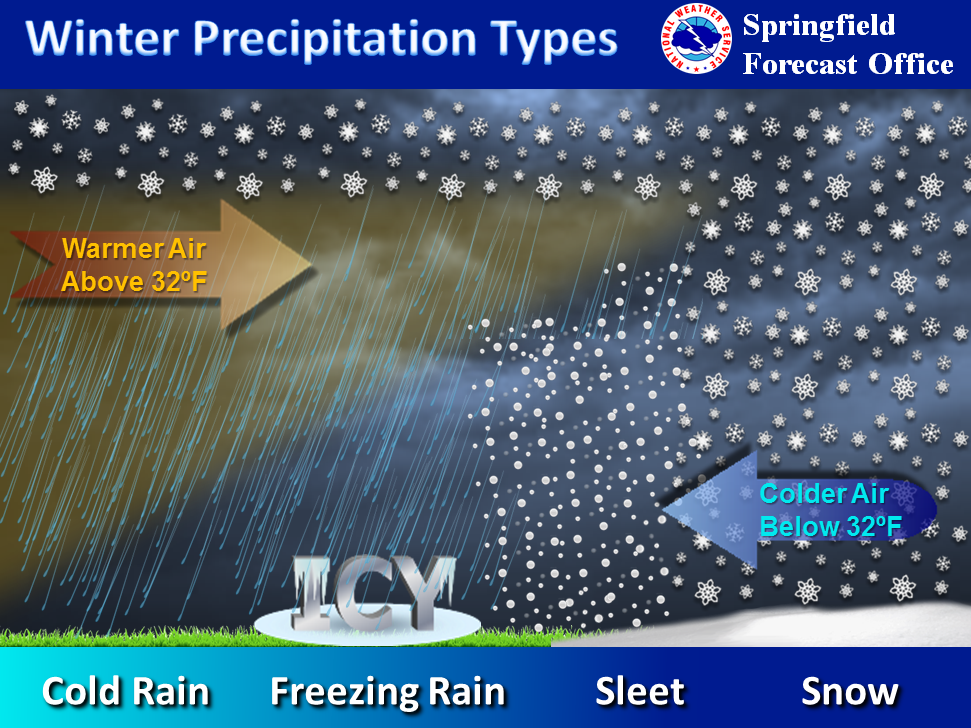
What determines whether you end up with snow, sleet, freezing rain, or rain? Temperatures aloft determine that. If a wedge of warm air nudges into the upper atmosphere it causes your snowflakes to melt into liquid.
.
.
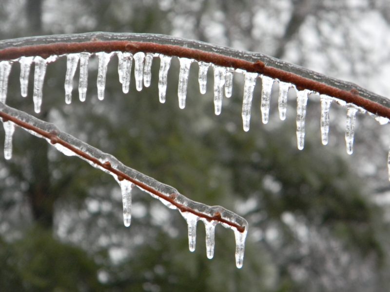
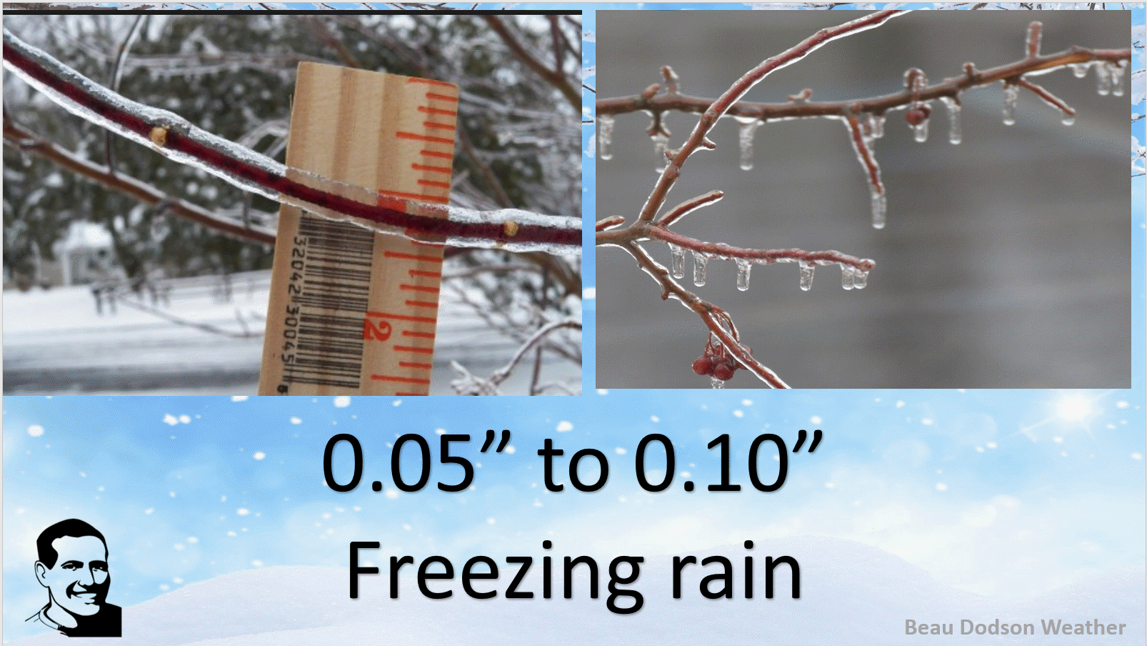
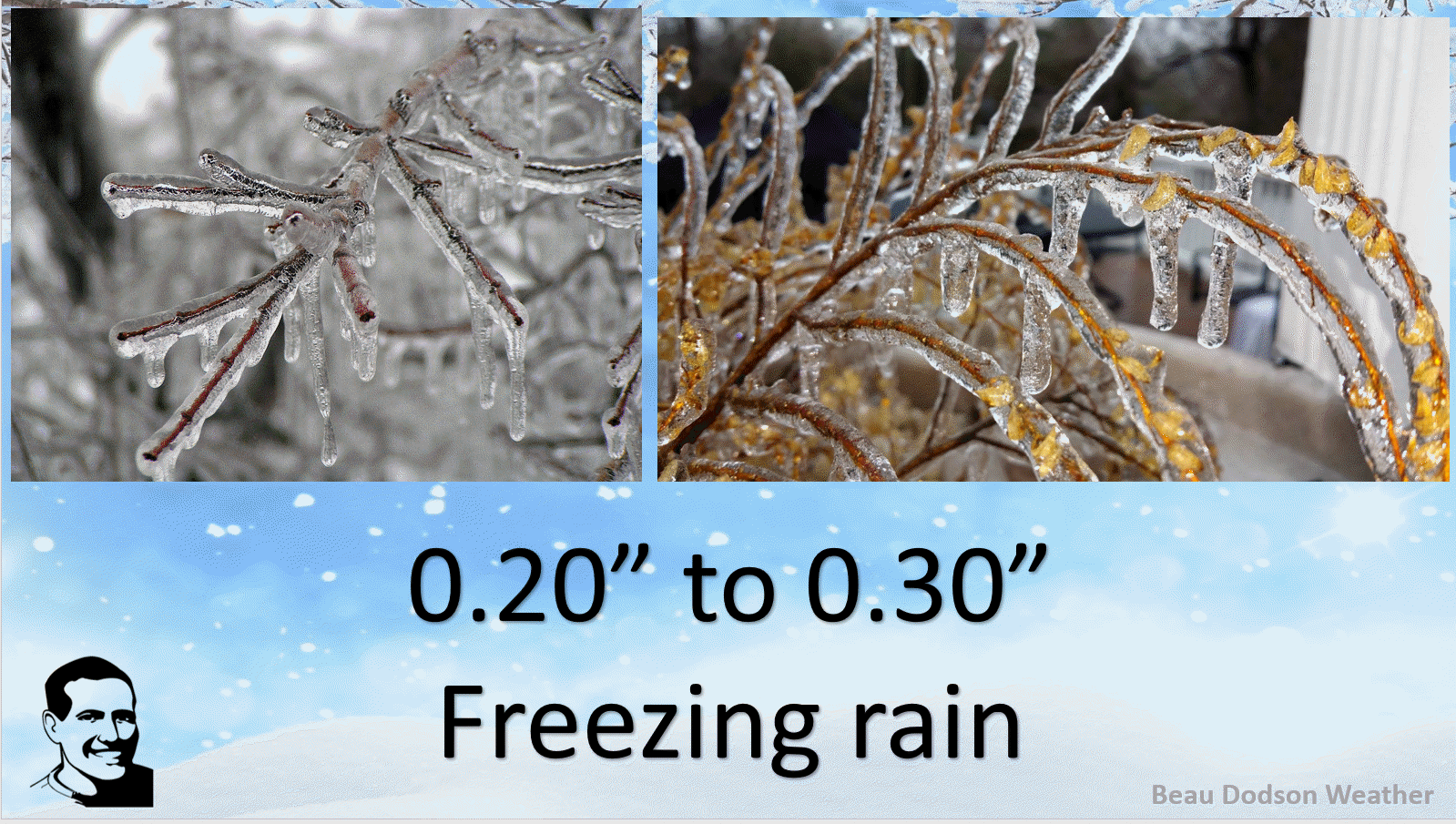
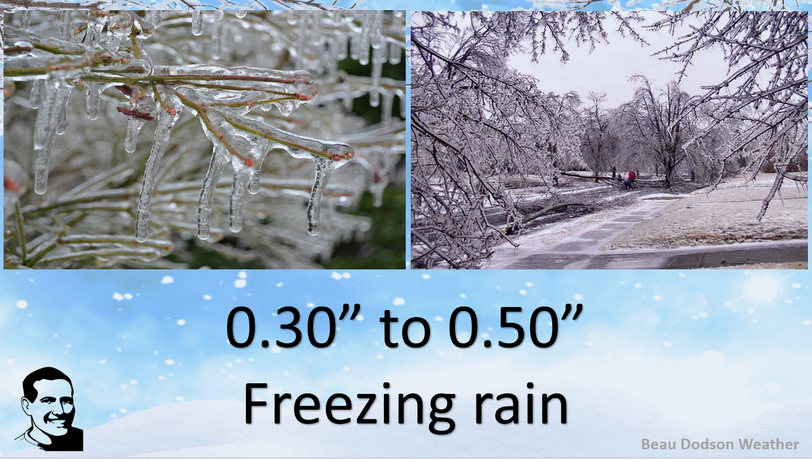
What is freezing rain? This is freezing rain.
.
.
The main impact will be icy roads, decks, porches, and sidewalks/parking lots. The current freezing rain outlook is for 0.05″ to 0.20″.
Let me show you what different ice totals look like.
.
.
.
.
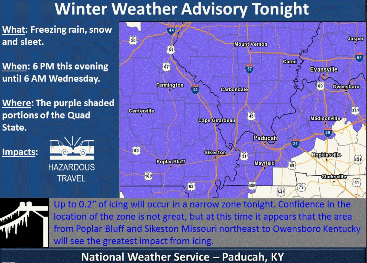
The Paducah, Kentucky, NWS has issued a winter weather advisory for much of the area. The southeast row of counties is questionable. Temperatures there may remain above freezing for most of the event.
A winter storm or ice storm warning is possible in the middle of this advisory, but Paducah wanted to wait and monitor today’s data. Either way, the main concern will be icy secondary roads, bridges, porches, and sidewalks/parking lots.
Here is their advisory.
Notice this does include the Missouri Bootheel and a few northwest Tennessee Counties, as well.
.
.
If a heavier band of precipitation does develop, then some tree damage and brief power outages could occur. Keep this in mind. I have that band extending from near Sikeston and then towards Paducah and then towards Owensboro. Perhaps a 10 to 15 mile wide band of heavier totals.
There should not be much snow with this event. Areas along and north of a line from near Perryville, Missouri towards Harrisburg, Illinois might see a dusting to an inch or two. This remains a bit of a question. Upper air soundings show a warm nudge of air that might prevent much snow from falling.
Northern portions of southeast Missouri and northern portions of southern Illinois may end with very little in the way of measurable precipitation. Keep that in mind, as well.
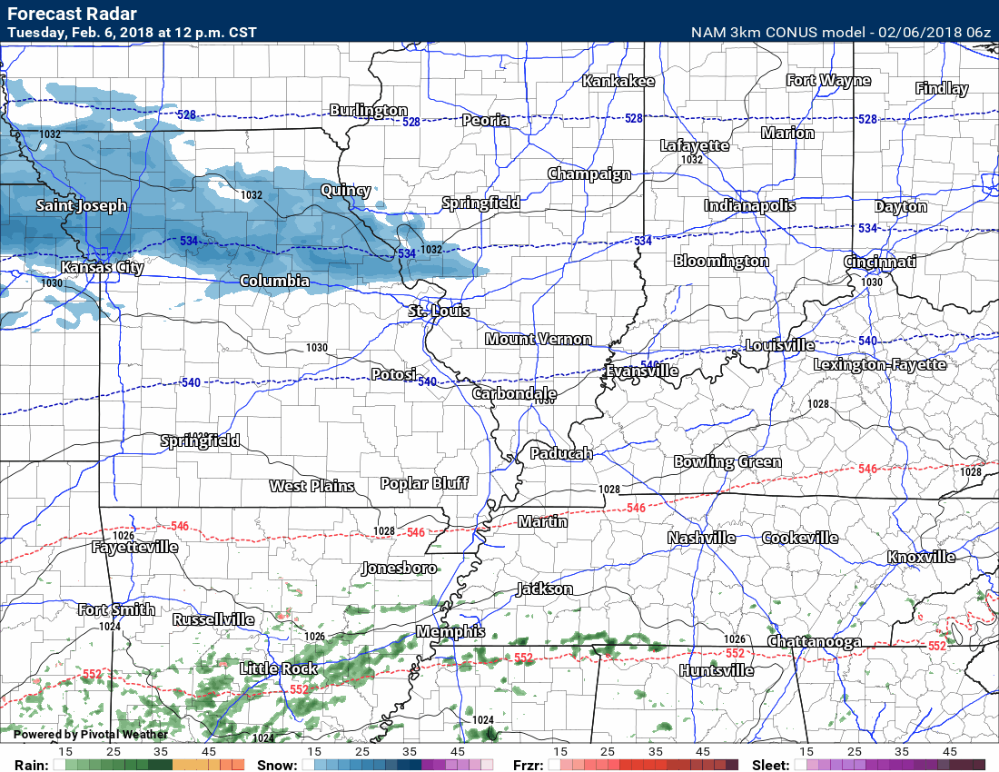
Here is the NAM model guidance future-cast radar from 12 PM today through 9 AM Wednesday. Green and yellow would be rain. Blue is snow. Pink and red would be freezing rain and sleet. It is a fast moving system. In and out of here fairly quickly.
This is what radar might look like (according to this one model).
Notice the 32 degree line cuts our area in half. Tough call on the exact placement of the 32 degree line.
.
.
Click images to enlarge.
You can see where the freezing line is situated on this graphic. This is the NAM model’s opinion. It could shift one or two counties. That could change the forecast for your backyard. Keep this in mind.
Some models are slightly warmer and some slightly colder. That leaves question on where to place the 32 degree line.
Time stamp upper left
.
.
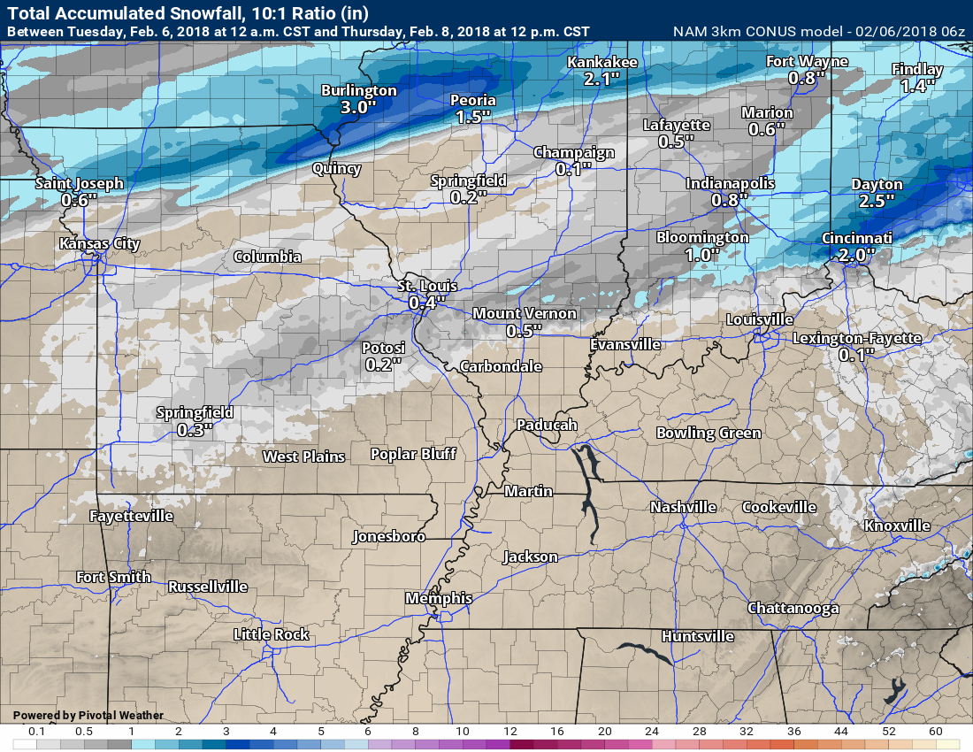
Here is the NAM model snow forecast for Tuesday afternoon into Wednesday morning. One models opinion. Not much snow.
.
.
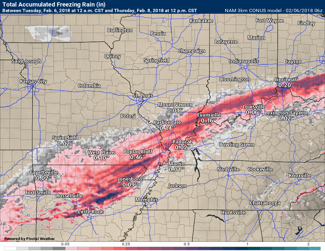
Here is the NAM models freezing rain forecast. You can see it places the freezing rain right through the heart of our local area.
The darker colors are where heavier totals could fall. Don’t get too caught up in the exact placement or numbers. Take the general idea that a band of freezing rain will cross the area tonight.
.
.
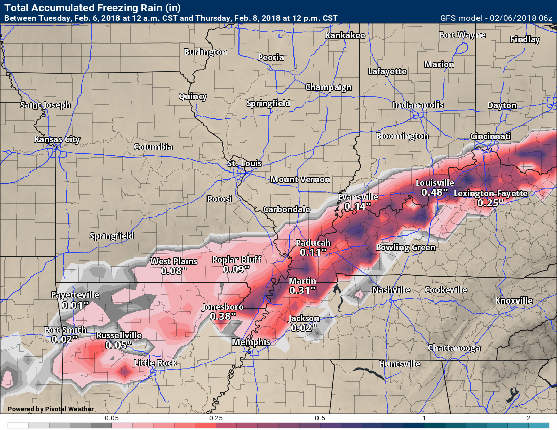
Here is the GFS model. This is the freezing rain forecast from that model. Typically, we cut these numbers in half. Accretion does not always keep up with accumulation. In other words if 0.50″ of rain falls, then 0.25″ of ice may accumulate. Dripping and other factors go into accretion. Accretion means how much ice accumulates.
For the most part totals range from a trace to 0.20″. Pockets of heavier totals may occur.
.
.
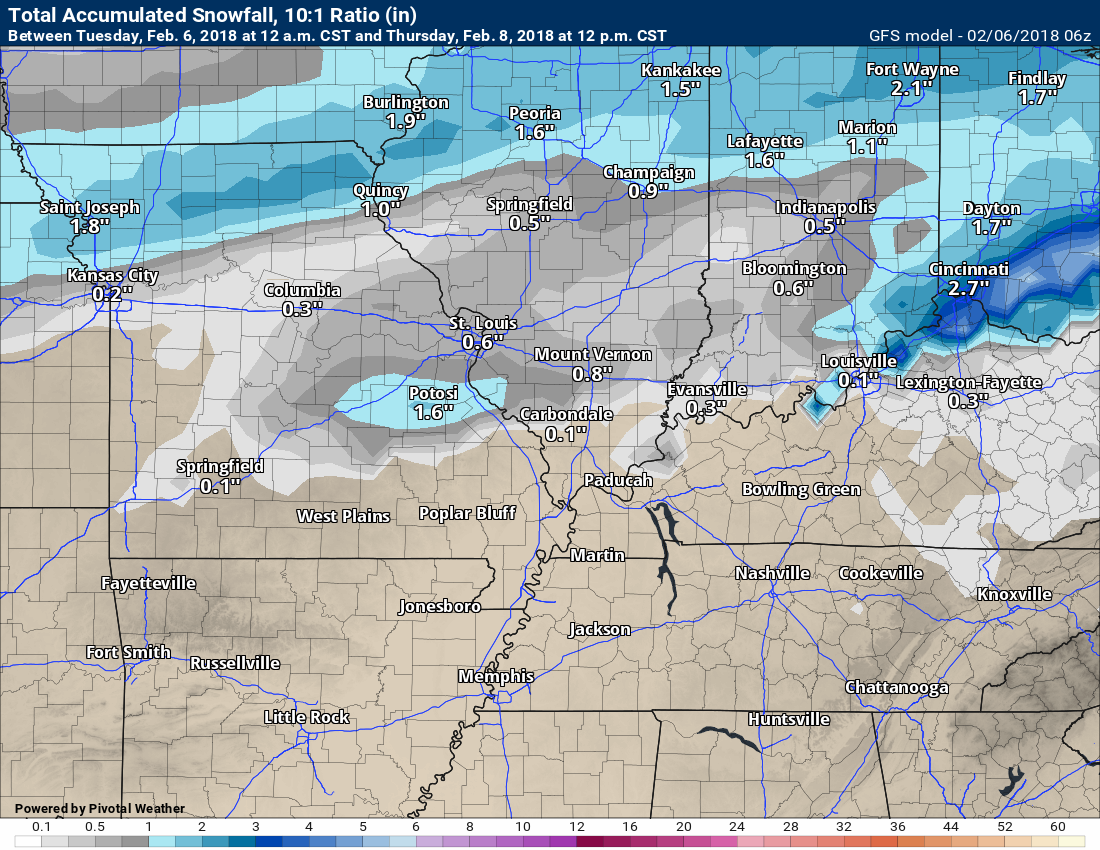
Here is the GFS snow forecast. Not much snow being produced by the models. This is mainly an ice event. According to the models, at least. That does make sense based on the warm nudge of air aloft.
.
.
Now let me show you what WPC is forecasting. They are a branch of NOAA.
.
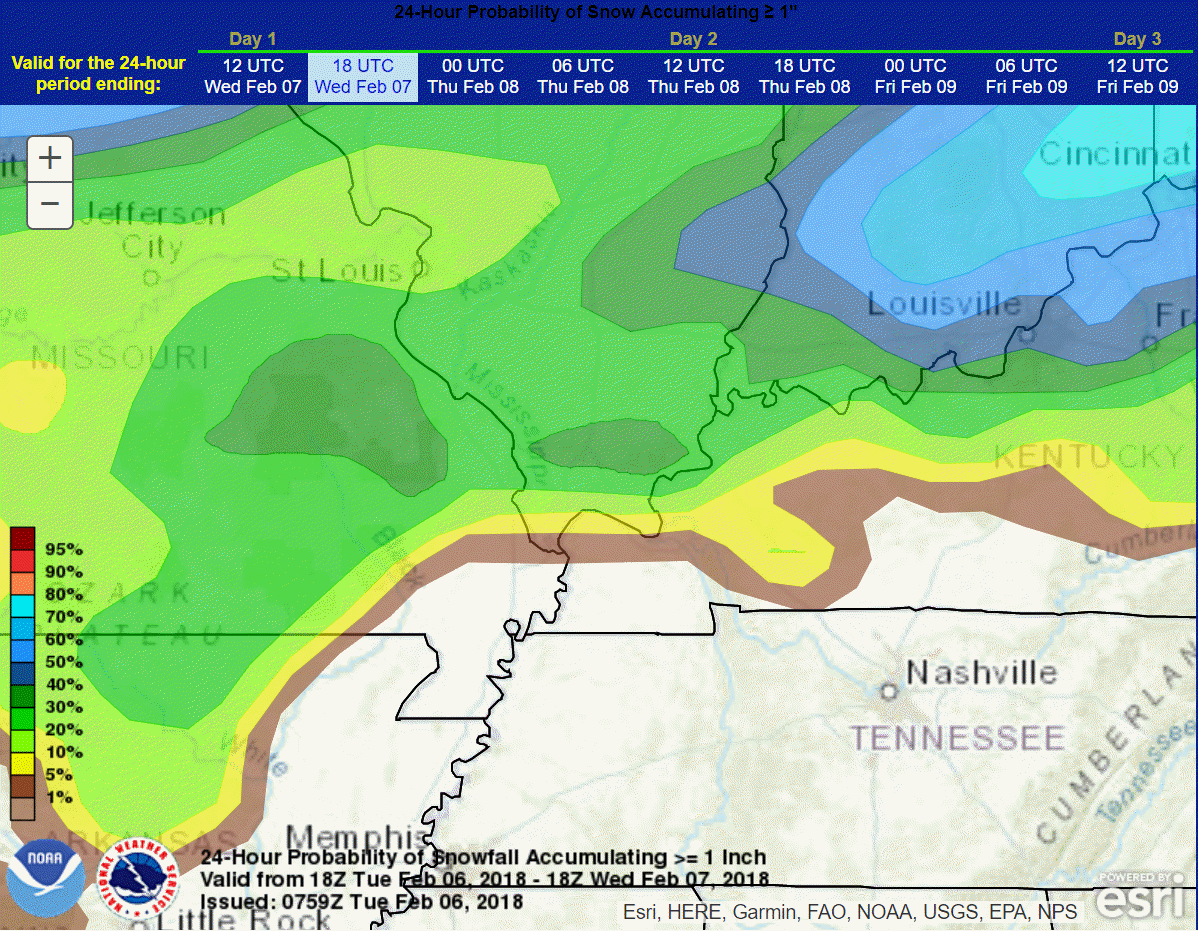
This first graphic is what is the percent chance of 1″ of snow from this system (Tuesday afternoon into Wednesday morning)
Odds do NOT favor much snow with this event.
This is a static image. The buttons won’t work for you.
.
.
.
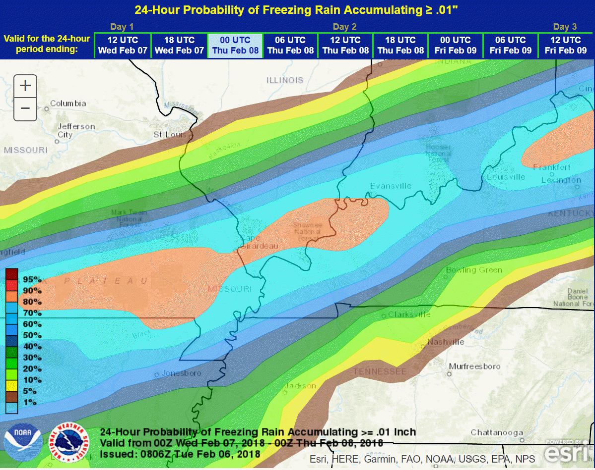
This next graphics is what is the % chance of at least 0.10″ of freezing rain accumulating.
.
.
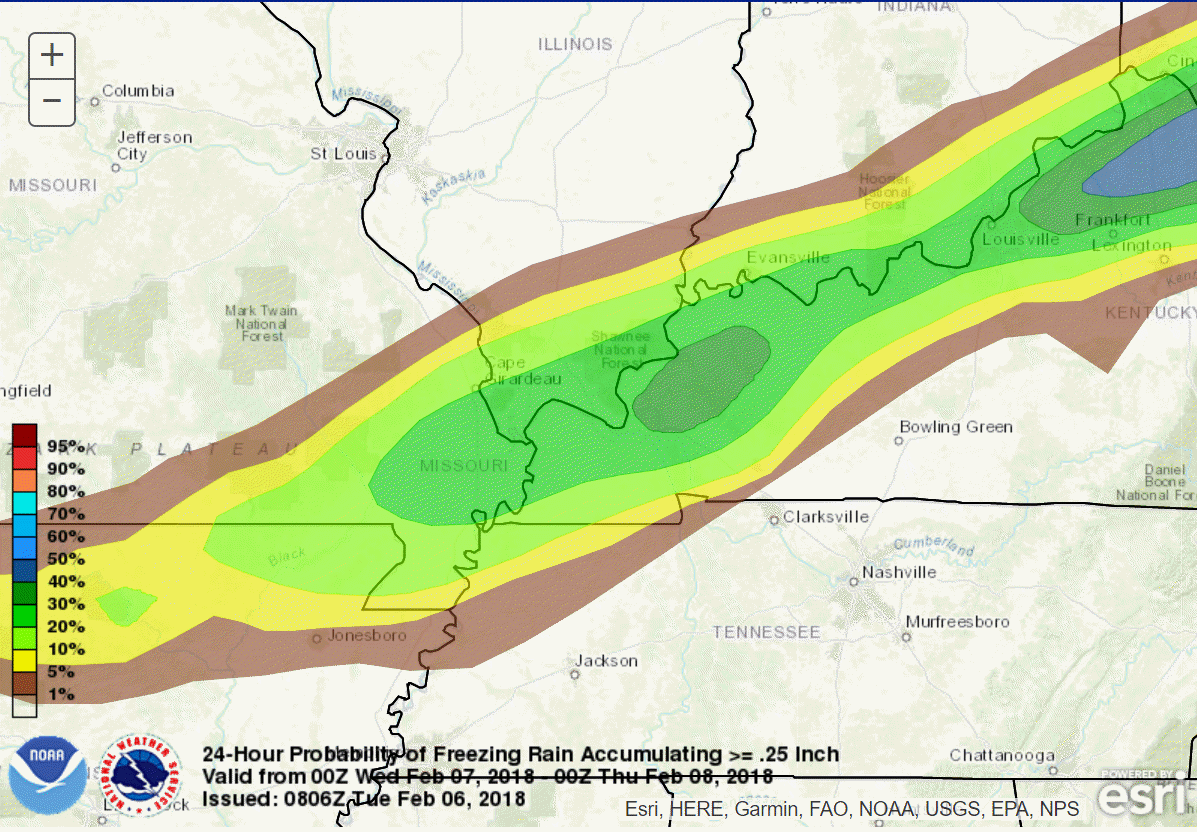
This next graphics is what is the % chance of 0.25″ of freezing rain accumulating.
.
.
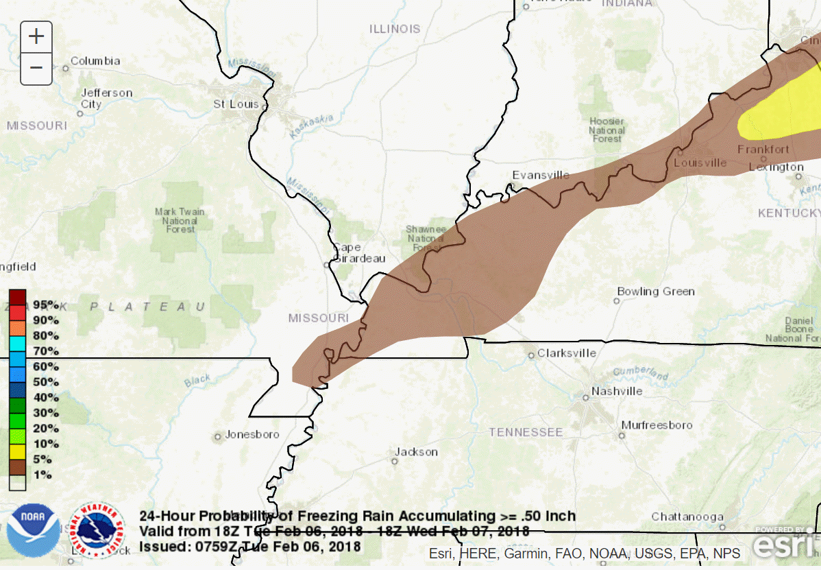
This next graphics is what is the % chance of 0.50″ of freezing rain accumulating.
.
.
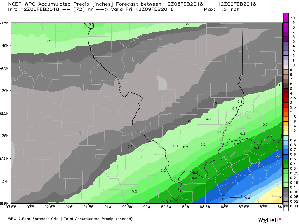
Here is the official WPC precipitation forecast map through Wednesday afternoon. Check out the SHARP cut-off between lighter totals and heavier totals.
The heaviest precipitation is forecast to fall in the all rain zone.
Notice portions of southeast Missouri and southern Illinois are in the less than 0.10″ zone. Keep in mind this is freezing rain, sleet, snow, and rain. It is the liquid amounts of precipitation.
Click image to enlarge.
.
.
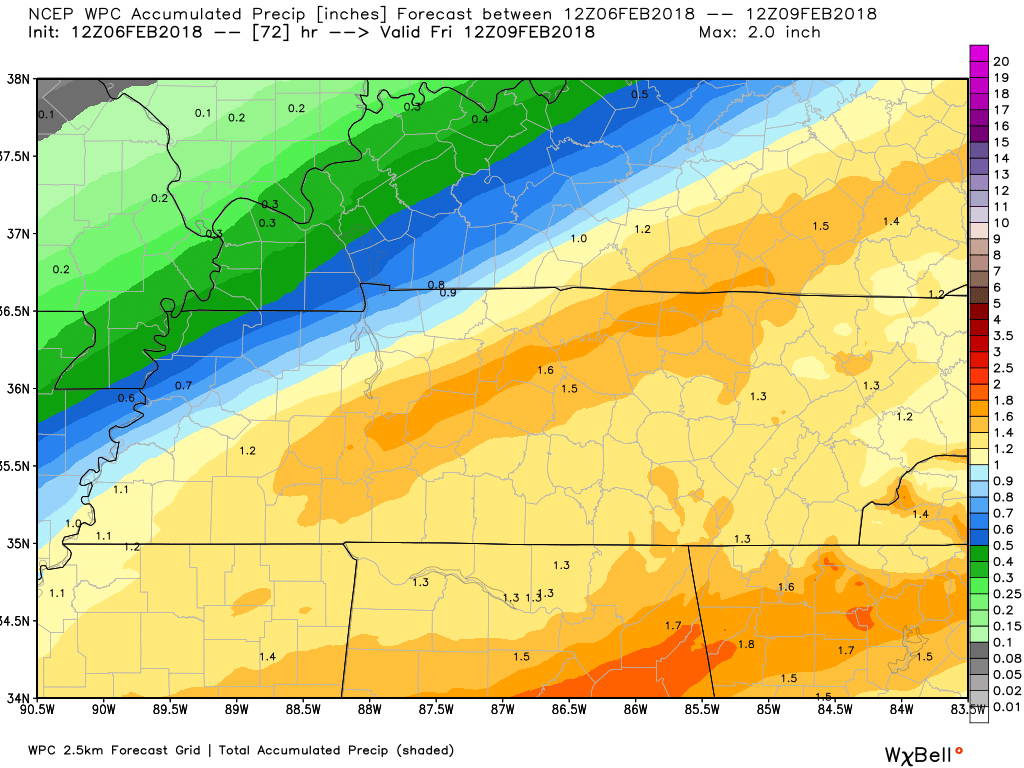
Here is the southeast view of that image. Again, SHARP cut-off on totals. Keep in mind this is showing you freezing rain, sleet, snow, and rain. It is the liquid amounts of precipitation.
.
.
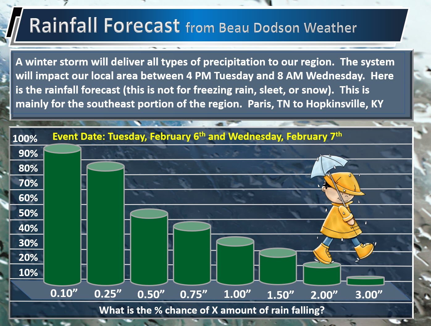
Here is my rainfall totals forecast.
What is the % chance of X amount of rain Tuesday afternoon through Wednesday morning?
This graphic is JUST for the rain zone. This is not for freezing rain, sleet, or snow.
.
.
Monitor updates.
Friday night into Sunday (February 9th through the 11th)
HIGHLIGHTS
- Another in a series of storm systems may spread precipitation back into our region late next week. Low confidence.
- It is too early to know what type of precipitation. Monitor updates
I will initiate a graphic on next weekends system. Still early to know the details on this one.
.
.


We offer regional radars and local city radars – if a radar does not update then try another one. Occasional browsers need their cache cleared. You may also try restarting your browser. This will usually fix any problems.
During the winter you can track snow and ice by clicking the winterize button on the local city view interactive radars.
You may email me at beaudodson@usawx.com
Interactive Weather Radar Page. Choose the city nearest your location: Click this link
National interactive radar: Click this link.