We have some great sponsors for the Weather Talk Blog. Please let our sponsors know that you appreciate their support for the Weather Talk Blog.
Milner and Orr Funeral Home and Cremation Services located in Paducah, Kentucky and three other western Kentucky towns – at Milner and Orr they believe in families helping families. You can find Milner and Orr on Facebook, as well.
![]()
.

For all of your families eye care needs. Visit their web-site here. Or, you can also visit their Facebook page.
.

Best at Enabling Body Shop Profitability since 1996. Located In Paducah Kentucky and Evansville Indiana; serving all customers in between. They provide Customer Service, along with all the tools necessary for body shops to remain educated and competitive. Click the logo above for their main web-site. You can find McClintock Preferred Finishes on Facebook, as well
.

Duck/goose decoys? Game calls? Optics? We have you covered! Click the logo above or visit Final Flight on Facebook, as well.
.
I have launched the new weather texting service! I could use your help. Be sure and sign up and fully support all of the weather data you see each day.
This is a monthly subscription service. Supporting this helps support everything else. The cost is $3 a month for one phone, $5 a month for three phones, and $10 a month for seven phones.
For more information visit BeauDodsonWeather.com
Or directly sign up at Weathertalk.com


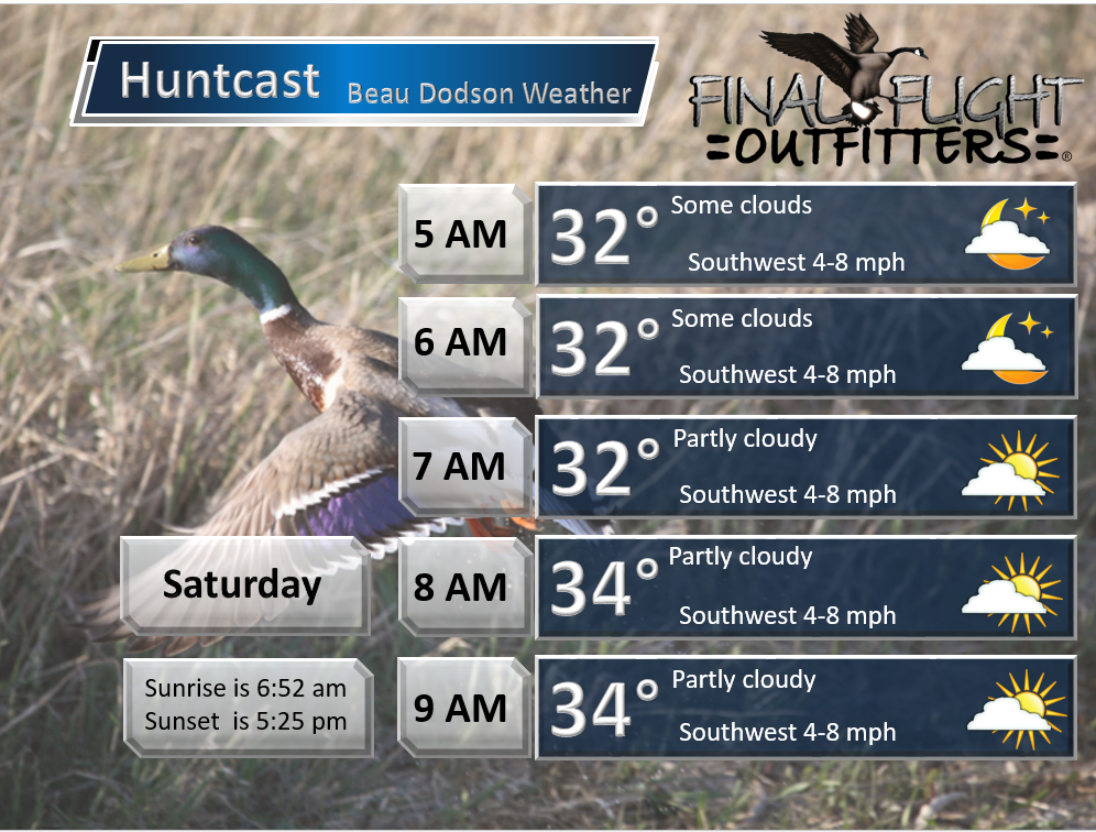
This forecast update covers far southern Illinois, far southeast Missouri, and far western Kentucky. See the coverage map on the right side of the blog.
Remember that weather evolves. Check back frequently for updates, especially during active weather.

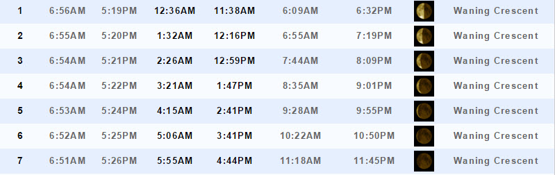
Friday night – Some clouds and cool.
Temperatures: Lows from 28-34 degrees
Winds: South winds at 3-6 mph
What is the chance for precipitation? 0%
Coverage of precipitation? None
My confidence in this part of the forecast verifying is High
Should I be concerned about snow or ice? No
Should I cancel my outdoor plans? No
Is severe weather expected? No
What impact is expected? None
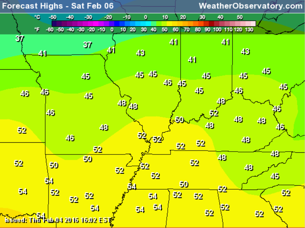
Saturday – Partly to mostly sunny and not too bad temperatures wise.
Temperatures: Highs will range 48-54 degrees.
Winds: South winds at 5-10 mph
What is the chance for precipitation? 0%
Coverage of precipitation? None
My confidence in this part of the forecast verifying is High
Should I be concerned about snow or ice? No
Should I cancel my outdoor plans? No
Is severe weather expected? No
What impact is expected? None
Saturday night – Mostly clear.
Temperatures: Lows from 28-32 degrees
Winds: South winds at 3-6 mph
What is the chance for precipitation? 0%
Coverage of precipitation? None
My confidence in this part of the forecast verifying is High
Should I be concerned about snow or ice? No
Should I cancel my outdoor plans? No
Is severe weather expected? No
What impact is expected? None
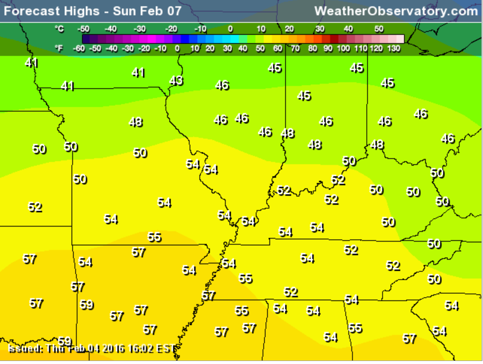
Sunday – Some increase in clouds.
Temperatures: Highs will range 50-54 degrees.
Winds: Southwest winds at 5-10 mph. Winds may become more westerly late in the day at 6-12 mph and gusty.
What is the chance for precipitation? 0%
Coverage of precipitation? None
My confidence in this part of the forecast verifying is High
Should I be concerned about snow or ice? No
Should I cancel my outdoor plans? No
Is severe weather expected? No
What impact is expected? None
Sunday Night – Increasing clouds. Chance for patchy light rain or snow late at night.
Temperatures: Lows from 32 to 36 degrees
Winds: Northwest winds at 8-16 mph
What is the chance for precipitation? 20%
Coverage of precipitation? Perhaps isolated
My confidence in this part of the forecast verifying is High
Should I be concerned about snow or ice? Not likely
Should I cancel my outdoor plans? No
Is severe weather expected? No
What impact is expected? None
Monday – Cloudy with scattered light rain or snow showers possible. Windy, at times. Falling temperatures during the day.
Temperatures: Highs will range 34 to 38 degrees. We may have falling temperatures during the afternoon.
Winds: Northwest winds at 10-20 mph and gusty.
What is the chance for precipitation? 40%
Coverage of precipitation? Scattered
My confidence in this part of the forecast verifying is High
Should I be concerned about snow or ice? Monitor updates
Should I cancel my outdoor plans? No
Is severe weather expected? No
What impact is expected? Wet roadways possible.
Monday Night – Cloudy and windy. Snow showers possible.
Temperatures: Lows from 22 to 28 degrees
Winds: Northwest winds at 8-16 mph
What is the chance for precipitation? 20%
Coverage of precipitation? Perhaps isolated
My confidence in this part of the forecast verifying is High
Should I be concerned about snow or ice? Not likely
Should I cancel my outdoor plans? No
Is severe weather expected? No
What impact is expected? Maybe some snow showers. Monitor updates.
Tuesday – Cloudy and cold. Light snow showers possible.
Temperatures: Highs will range 24 to 28 degrees
Winds: Northwest winds at 8-16 mph.
What is the chance for precipitation? 40%
Coverage of precipitation? Scattered
My confidence in this part of the forecast verifying is Medium
Should I be concerned about snow or ice? Monitor updates
Should I cancel my outdoor plans? No
Is severe weather expected? No
What impact is expected? Perhaps some snow showers. Monitor updates


Don’t forget to check out the Southern Illinois Weather Observatory web-site for weather maps, tower cams, scanner feeds, radars, and much more! Click here

An explanation of what is happening in the atmosphere over the coming days…
Highlights
1. A nice Saturday
2. Decent Sunday for the region
3. Unsettled for Monday into Tuesday night as cold air arrives
4. Maybe some rain/snow mix, snow showers, or light snow Sunday night into Tuesday
5. Much colder Monday into Wednesday
Well, the weekend is shaping up to be a decent one. Who can complain about 50s on Saturday? Well, yes all of you snow geese in the group. But, everyone else is loving it.
Saturday is once again the pick day of the week. Didn’t we do this last weekend?
By Sunday our next weather maker will already be knocking on our door. But, temperatures on Sunday won’t be too bad. Maybe some more clouds. Highs into the 50s.
An arctic blast of cold air is forecast to move into the region starting on Sunday night and lasting into the new work week. The true cold air won’t arrive until Monday night into Wednesday.
There is a bit of moisture with this system. And, some rain/snow showers will be possible as early as Sunday night. As colder air arrives we might even see some snow showers or light snow develop on Monday into Tuesday evening.
At this time, this looks to be a light event. And, the best chances for precipitation may end up over our northeastern and eastern counties.
Precipitation totals should range from a trace to maybe 0.10″-0.20″. If that were to be snow then maybe someone has a dusting to an inch or two. Low confidence this far out. A lot of the snow talk will depend on how far south and west the big low ends up. The low will be focused over the Great Lakes. A bit of an unusual way for us to have snow showers. But, not unheard of. Big upper level lows can do that.
The bigger story will be the cold air. Definitely looking at much chillier readings on Monday into at least Wednesday.
Our roller-coaster continues! Up and down we go.
Let’s monitor February 14th-18th for a bigger precipitation event.
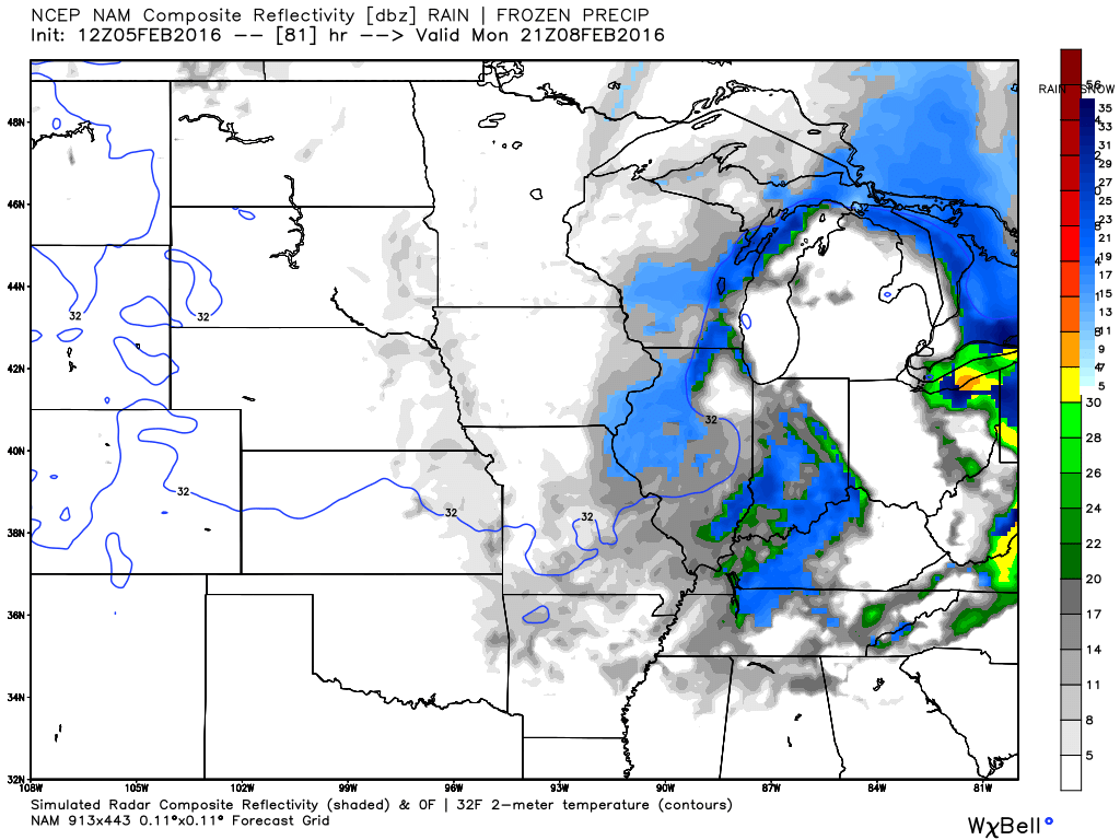
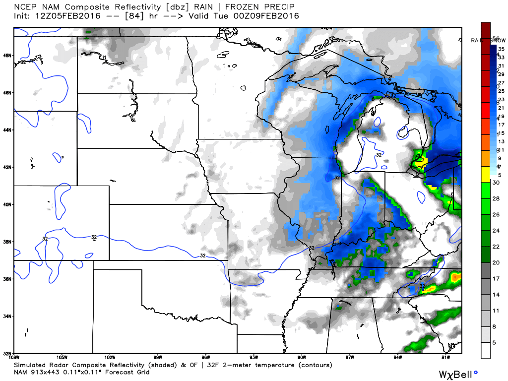
Here are some future-cast radars for Monday afternoon and evening from the NAM model guidance. Maybe some light snow in the region. We shall see.
Monday afternoon around 3 pm
Monday evening around 6 pm

No winter weather anticipated through Sunday afternoon.
Rain/snow mix possible Sunday night. Maybe some snow showers Monday and Tuesday.

Saturday – No snow or ice anticipated.
Sunday – No snow or ice anticipated.
Sunday night – Light rain or rain/snow showers possible.
Monday – Monitoring for some light precipitation
Tuesday – Monitoring for some light precipitation
Wednesday – Snow and ice is unlikely

No major changes.

No major concerns. Quiet weather for a few days.


No wild card in this update.

How much precipitation should we expect over the next few days?
Dry through Friday. Likely dry through the weekend, as well.
Perhaps some light precipitation on Monday and Tuesday. Less than 0.20″ melted.

Can we expect severe thunderstorms over the next 24 to 48 hours? Remember that a severe thunderstorm is defined as a thunderstorm that produces 58 mph winds or higher, quarter size hail or larger, and/or a tornado.
The thunderstorm threat level will be a ZERO for the rest of the week.

Here is the official 6-10 day and 8-14 day temperature and precipitation outlook. Check the date stamp at the top of each image (so you understand the time frame).
The forecast maps below are issued by the Weather Prediction Center (NOAA).


The latest 8-14 day temperature and precipitation outlook. Note the dates are at the top of the image. These maps DO NOT tell you how high or low temperatures or precipitation will be. They simply give you the probability as to whether temperatures or precipitation will be above or below normal.


Here are the current river stage forecasts. You can click your state and then the dot for your location. It will bring up the full forecast and hydrograph.
Click Here For River Stage Forecasts…

Who do you trust for your weather information and who holds them accountable?
I have studied weather in our region since the late 1970’s. I have 37 years of experience in observing our regions weather patterns. My degree is in Broadcast Meteorology from Mississippi State University and an Associate of Science (AS). I am currently working on my Bachelor’s Degree in Geoscience.
My resume includes:
Member of the American Meteorological Society.
NOAA Weather-Ready Nation Ambassador.
Meteorologist for McCracken County Emergency Management. I served from 2005 through 2015.
I own and operate the Southern Illinois Weather Observatory.
Recipient of the Mark Trail Award, WPSD Six Who Make A Difference Award, Kentucky Colonel, and the Caesar J. Fiamma” Award from the American Red Cross.
In 2009 I was presented with the Kentucky Office of Highway Safety Award.
Recognized by the Kentucky House of Representatives for my service to the State of Kentucky leading up to several winter storms and severe weather outbreaks.
I am also President of the Shadow Angel Foundation which serves portions of western Kentucky and southern Illinois.
There is a lot of noise on the internet. A lot of weather maps are posted without explanation. Over time you should learn who to trust for your weather information.
My forecast philosophy is simple and straight forward.
- Communicate in simple terms
- To be as accurate as possible within a reasonable time frame before an event
- Interact with you on Twitter, Facebook, and the blog
- Minimize the “hype” that you might see on television or through other weather sources
- Push you towards utilizing wall-to-wall LOCAL TV coverage during severe weather events
I am a recipient of the Mark Trail Award, WPSD Six Who Make A Difference Award, Kentucky Colonel, and the Caesar J. Fiamma” Award from the American Red Cross. In 2009 I was presented with the Kentucky Office of Highway Safety Award. I was recognized by the Kentucky House of Representatives for my service to the State of Kentucky leading up to several winter storms and severe weather outbreaks.
If you click on the image below you can read the Kentucky House of Representatives Resolution.

Many of my graphics are from www.weatherbell.com – a great resource for weather data, model data, and more


You can sign up for my AWARE email by clicking here I typically send out AWARE emails before severe weather, winter storms, or other active weather situations. I do not email watches or warnings. The emails are a basic “heads up” concerning incoming weather conditions.