
WeatherTalk monthly operating costs can top $2000.00. Your $5 subscription helps pay for those costs. I work for you.
The $5 will allow you to register up to seven phones!
For $5 a month you can receive the following. You may choose to receive these via your WeatherTalk app or regular text messaging.
Severe weather app/text alerts from my keyboard to your app/cell phone. These are hand typed messages from me to you. During tornado outbreaks, you will receive numerous app/text messages telling you exactly where the tornado is located.
- Daily forecast app/texts from my computer to your app/cell phone.
- Social media links sent directly to your app/cell phone. When I update the blog, videos, or Facebook you will receive the link.
- AWARE emails. These emails keep you well ahead of the storm. They give you several days of lead time before significant weather events.
- Direct access to Beau via text and email. Your very own personal meteorologist. I work for you!
- Missouri and Ohio Valley centered video updates
- Long-range weather videos
- Week one, two, three and four temperature and precipitation outlooks.
Monthly outlooks. - Your subscription also will help support several local charities.
Would you like to subscribe? Subscribe at www.beaudodsonweather.com
Typical progression on a severe weather day for subscribers.


I encourage subscribers to use the app vs regular text messaging. We have found text messaging to be delayed during severe weather. The app typically will receive the messages instantly. I recommend people have three to four methods of receiving their severe weather information.
Remember, my app and text alerts are hand typed and not computer generated. You are being given my personal attention during significant weather events.

WWW.WEATHERTALK.COM subscribers, here is my day to day schedule for your weather products.
These are bonus videos and maps for subscribers. I bring these to you from the BAMwx team. I pay them to help with videos.
The Ohio and Missouri Valley videos cover most of our area. They do not have a specific Tennessee Valley forecast but may add one in the future.
The long-range video is technical. Over time, you can learn a lot about meteorology from the long range video. Just keep in mind, it is a bit more technical.


Subscribe at www.weathertalk.com
![]()

![]()
February 5, 2019
Tuesday’s Forecast: Patchy fog and mist. Widespread clouds. A chance of widely scattered showers. Isolated thunderstorms. The region will be split between warm and cool.
My confidence in the forecast verifying: High (80% confidence in the forecast)
Temperature range: MO Bootheel 56° to 60° SE MO 48° to 54° South IL 46° to 54° West KY 55° to 65° (warmest east of LBL) NW TN 62° to 66°
Wind direction and speed: East and northeast at 6 to 12 mph
Wind chill or heat index (feels like) temperature forecast:
What is the chance/probability of precipitation? MO Bootheel 30% MO 30% IL 30% KY 30% TN 30%
Note, what does the % chance actually mean? A 20% chance of rain does not mean it won’t rain. It simply means most areas will remain dry.
Coverage of precipitation: Widely scattered
Is flash flooding anticipated? No
Will there be accumulating snow or ice? No
Will non-accumulating snow or ice occur? No
Are icy road conditions anticipated? No
Is severe weather expected? No
The NWS officially defines severe weather as 58 mph wind or great, 1″ hail or larger, and/or tornadoes
Is lightning anticipated? Slight chance
What impacts are anticipated from the weather? A few wet roadways. Isolated lightning. Low visibility in fog.
Should I cancel my outdoor plans? No, but check radars
UV Index: 2 Low
Sunrise: 6:55 AM
Tuesday night Forecast: Patchy fog. Cloudy with widespread rain showers developing. A thunderstorm possible. Mild for February. Breezy, at times.
My confidence in the forecast verifying: High (80% confidence in the forecast)
Temperature range: MO Bootheel 53° to 56° SE MO 44° north to 50° south South IL 42° to 52° (coolest north vs south) West KY 50° to 54° NW TN 58° to 62°
Wind direction and speed: East and southeast wind at 6 to 12 mph
Wind chill or heat index (feels like) temperature forecast:
What is the chance/probability of precipitation? MO Bootheel 80% MO 80% IL 80% KY 80% TN 80%
Note, what does the % chance actually mean? A 20% chance of rain does not mean it won’t rain. It simply means most areas will remain dry
Coverage of precipitation: Widespread
Is flash flooding anticipated? No
Will there be accumulating snow or ice? No
Will non-accumulating snow or ice occur? No
Are icy road conditions anticipated? No
Is severe weather expected? No
The NWS officially defines severe weather as 58 mph wind or great, 1″ hail or larger, and/or tornadoes
Is lightning anticipated? Yes
What impacts are anticipated from the weather? Wet roadways. Isolated lightning. Low visibility in fog.
Should I cancel my outdoor plans? Have a plan B (esp late)
Sunset: 5:24 PM
Moonrise: 7:32 AM
The phase of the moon: New
Moonset: 6:14 PM
![]()
February 6, 2019
Wednesday’s Forecast: Showers and thunderstorms. Locally heavy rain. A few storms could be strong.
My confidence in the forecast verifying: High (90% confidence in the forecast)
Temperature range: MO Bootheel 64° to 68° SE MO 52° to 64° South IL 52° north to 66° south West KY 64° to 68° NW TN 66° to 68°
Wind direction and speed: South and southwest 8 to 16 mph becoming 6 to 12 mph
Wind chill or heat index (feels like) temperature forecast:
What is the chance/probability of precipitation? MO Bootheel 100% MO 100% IL 100% KY 100% TN 100%
Note, what does the % chance actually mean? A 20% chance of rain does not mean it won’t rain. It simply means most areas will remain dry.
Coverage of precipitation: Numerous / widespread
Is flash flooding anticipated? Low risk of flash flooding. Some general flooding is possible this afternoon.
Will there be accumulating snow or ice? No
Will non-accumulating snow or ice occur? No
Are icy road conditions anticipated? No
Is severe weather expected? Possible. High wind is the main concern. A low-end tornado risk. Overall confidence in severe weather is fairly low.
The NWS officially defines severe weather as 58 mph wind or great, 1″ hail or larger, and/or tornadoes
Is lightning anticipated? Yes
What impacts are anticipated from the weather? Moderate rain. Lightning. Monitor severe weather concerns.
Should I cancel my outdoor plans? Have a plan B
UV Index: 1 Low
Sunrise: 6:54 AM
Wednesday night Forecast: Rising temperatures overnight as a warm front moves northward. Showers and thunderstorms. Locally heavy rain. A strong thunderstorm is possible. Mild. Breezy.
My confidence in the forecast verifying: High (90% confidence in the forecast)
Temperature range: MO Bootheel 60° to 64° SE MO 50° to 60° South IL 52° to 60° West KY 60° to 65° NW TN 62° to 65°
Wind direction and speed: South at 10 to 20 mph and gusty
Wind chill or heat index (feels like) temperature forecast:
What is the chance/probability of precipitation? MO Bootheel 90% MO 90% IL 90% KY 90% TN 90%
Note, what does the % chance actually mean? A 20% chance of rain does not mean it won’t rain. It simply means most areas will remain dry
Coverage of precipitation: Widespread
Is flash flooding anticipated? Possible.
Will there be accumulating snow or ice? No
Will non-accumulating snow or ice occur? No
Are icy road conditions anticipated? No
Is severe weather expected? Monitor updates. Strong thunderstorms can’t be ruled out. High wind is the main concern. Isolated tornado risk. Overall confidence in severe weather is fairly low.
The NWS officially defines severe weather as 58 mph wind or great, 1″ hail or larger, and/or tornadoes
Is lightning anticipated? Yes
What impacts are anticipated from the weather? Heavy rain. Lightning. Gusty winds. Monitor severe weather concerns.
Should I cancel my outdoor plans? Have a plan B.
Sunset: 5:25 PM
Moonrise: 8:05 AM
The phase of the moon: Waxing Crescent
Moonset: 7:11 PM
February 7, 2019
Thursday’s Forecast: Showers and thunderstorms. Heavy rain is possible. Mild. Monitor the risk of a few strong thunderstorms. Windy. Turning colder as the front moves east.
My confidence in the forecast verifying: High (80% confidence in the forecast)
Temperature range: FALLING TEMPERATURES BEHIND THE COLD FRONT MO Bootheel 64° to 68° SE MO 62° to 66° South IL 62° to 66° West KY 64° to 68° NW TN 66° to 68°
Wind direction and speed: South and southwest at 15 to 30 mph and gusty
Wind chill or heat index (feels like) temperature forecast:
What is the chance/probability of precipitation? MO Bootheel 90% MO 90% IL 90% KY 90% TN 90%
Note, what does the % chance actually mean? A 20% chance of rain does not mean it won’t rain. It simply means most areas will remain dry.
Coverage of precipitation: Numerous
Is flash flooding anticipated? Yes.
Will there be accumulating snow or ice? No
Will non-accumulating snow or ice occur? No
Are icy road conditions anticipated? No
Is severe weather expected? Yes. There is a risk of severe weather. The main concern will be during the AM hours.
The NWS officially defines severe weather as 58 mph wind or great, 1″ hail or larger, and/or tornadoes
Is lightning anticipated? Yes
What impacts are anticipated from the weather? Heavy rain. Flooding or flash flooding. Lightning. Gusty winds. Monitor the threat of severe weather.
Should I cancel my outdoor plans? Have a plan B.
UV Index: 1 Low
Sunrise: 6:53 AM
Thursday night Forecast: Rain ending west to east. Sharply colder. A small chance of flurries as the colder air arrives. Watch for black ice in areas where moisture remains as the cold air arrives.
My confidence in the forecast verifying: Medium (60% confidence in the forecast)
Temperature range: MO Bootheel 23° to 26° SE MO 16° to 22° South IL 18° to 24° West KY 22° to 24° NW TN 23° to 26°
Wind direction and speed: Becoming west and northwest at 15 to 30 mph and gusty.
Wind chill or heat index (feels like) temperature forecast: 5 to 15
What is the chance/probability of precipitation? MO Bootheel 20% MO 20% IL 30% KY 40% TN 40%
Note, what does the % chance actually mean? A 20% chance of rain does not mean it won’t rain. It simply means most areas will remain dry
Coverage of precipitation: Ending west to east.
Is flash flooding anticipated? Yes.
Will there be accumulating snow or ice? Unlikely
Will non-accumulating snow or ice occur? Possible
Are icy road conditions anticipated? Unlikely. Watch for black ice in areas where moisture remains as the cold air arrives.
Is severe weather expected? No
The NWS officially defines severe weather as 58 mph wind or great, 1″ hail or larger, and/or tornadoes
Is lightning anticipated? Perhaps early. Most likely the lightning concerns will be over with.
What impacts are anticipated from the weather? Wet roadways. Watch for black ice in areas where moisture remains as the cold air arrives.
Should I cancel my outdoor plans? Have a plan B.
Sunset: 5:26 PM
Moonrise: 8:35 AM
The phase of the moon: Waxing Crescent
Moonset: 8:07 PM
![]()
February 8, 2019
Friday’s Forecast: Mostly sunny and colder.
My confidence in the forecast verifying: Medium (60% confidence in the forecast)
Temperature range: MO Bootheel 32° to 35° SE MO 28° to 34° South IL 28° to 34° West KY 32° to 34° NW TN 33° to 36°
Wind direction and speed: Northwest at 10 to 20 mph
Wind chill or heat index (feels like) temperature forecast: 15 to 25
What is the chance/probability of precipitation? MO Bootheel 0% MO 0% IL 0% KY 0% TN 0%
Note, what does the % chance actually mean? A 20% chance of rain does not mean it won’t rain. It simply means most areas will remain dry.
Coverage of precipitation: None
Is flash flooding anticipated? No
Will there be accumulating snow or ice? No
Will non-accumulating snow or ice occur? No
Are icy road conditions anticipated? No
Is severe weather expected? No
The NWS officially defines severe weather as 58 mph wind or great, 1″ hail or larger, and/or tornadoes
Is lightning anticipated? No
What impacts are anticipated from the weather? None
Should I cancel my outdoor plans? No
UV Index: 3 Moderate
Sunrise: 6:52 AM
Friday night Forecast: Mostly clear and cold.
My confidence in the forecast verifying: Medium (40% confidence in the forecast)
Temperature range: MO Bootheel 20° to 24° SE MO 14° to 18° South IL 14° to 18° West KY 16° to 22° NW TN 18° to 22°
Wind direction and speed: North at 5 to 10 mph
Wind chill or heat index (feels like) temperature forecast: 10 to 15
What is the chance/probability of precipitation? MO Bootheel 0% MO 0% IL 0% KY 0% TN 0%
Note, what does the % chance actually mean? A 20% chance of rain does not mean it won’t rain. It simply means most areas will remain dry
Coverage of precipitation: None
Is flash flooding anticipated? No
Will there be accumulating snow or ice? No
Will non-accumulating snow or ice occur? No
Are icy road conditions anticipated? No
Is severe weather expected? No
The NWS officially defines severe weather as 58 mph wind or great, 1″ hail or larger, and/or tornadoes
Is lightning anticipated? No
What impacts are anticipated from the weather? None
Should I cancel my outdoor plans? No
Sunset: 5:27 PM
Moonrise: 9:03 AM
The phase of the moon: Waxing Crescent
Moonset: 9:03 PM
February 9, 2019
Saturday’s Forecast: Partly sunny. Cold.
My confidence in the forecast verifying: Medium (50% confidence in the forecast)
Temperature range: MO Bootheel 40° to 44° SE MO 35° to 40° South IL 35° to 40° West KY 36° to 42° NW TN 38° to 42°
Wind direction and speed: Northeast at 5 to 10 mph.
Wind chill or heat index (feels like) temperature forecast: 30 to 35
What is the chance/probability of precipitation? MO Bootheel 0% MO 0% IL 0% KY 0% TN 0%
Note, what does the % chance actually mean? A 20% chance of rain does not mean it won’t rain. It simply means most areas will remain dry.
Coverage of precipitation: None
Is flash flooding anticipated? No
Will there be accumulating snow or ice? No
Will non-accumulating snow or ice occur? No
Are icy road conditions anticipated? No
Is severe weather expected? No
The NWS officially defines severe weather as 58 mph wind or great, 1″ hail or larger, and/or tornadoes
Is lightning anticipated? No
What impacts are anticipated from the weather? None
Should I cancel my outdoor plans? No
UV Index: 3 Moderate
Sunrise: 6:51 AM
Saturday night Forecast: Increasing clouds. A slight chance of light snow late.
My confidence in the forecast verifying: Low (30% confidence in the forecast)
Temperature range: MO Bootheel 30° to 35° SE MO 25° to 30° South IL 24° to 28° West KY 28° to 32° NW TN 30° to 34°
Wind direction and speed: East at 6 to 12 mph
Wind chill or heat index (feels like) temperature forecast: 30 to 40
What is the chance/probability of precipitation? MO Bootheel 20% MO 30% IL 20% KY 10% TN 0%
Note, what does the % chance actually mean? A 20% chance of rain does not mean it won’t rain. It simply means most areas will remain dry
Coverage of precipitation: None to isolated
Is flash flooding anticipated? No
Will there be accumulating snow or ice? Small chance after 2 AM
Will non-accumulating snow or ice occur? Small chance of light snow late
Are icy road conditions anticipated? Small chance after 2 AM
Is severe weather expected? No
The NWS officially defines severe weather as 58 mph wind or great, 1″ hail or larger, and/or tornadoes
Is lightning anticipated? No
What impacts are anticipated from the weather? Most likely none. Monitor updates.
Should I cancel my outdoor plans? No
Sunset: 5:28 PM
Moonrise: 9:32 AM
The phase of the moon: Waxing Crescent
Moonset: 10:00 PM
February 10, 2019
Sunday’s Forecast: Mostly cloudy with snow or rain showers possible. Any snow would turn to all rain as temperatures rise.
My confidence in the forecast verifying: Low (30% confidence in the forecast)
Temperature range: MO Bootheel 43° to 46° SE MO 38° to 44° South IL 40° to 45° West KY 43° to 46° NW TN 43° to 46°
Wind direction and speed: East at 6 to 12 mph
Wind chill or heat index (feels like) temperature forecast: 30 to 40
What is the chance/probability of precipitation? MO Bootheel 50% MO 50% IL 40% KY 50% TN 60%
Note, what does the % chance actually mean? A 20% chance of rain does not mean it won’t rain. It simply means most areas will remain dry.
Coverage of precipitation: Scattered
Is flash flooding anticipated? No
Will there be accumulating snow or ice? Monitor
Will non-accumulating snow or ice occur? Yes
Are icy road conditions anticipated? Monitor
Is severe weather expected? No
The NWS officially defines severe weather as 58 mph wind or great, 1″ hail or larger, and/or tornadoes
Is lightning anticipated? No
What impacts are anticipated from the weather? Wet roadways. Monitor the AM hours in case the snow accumulates (briefly).
Should I cancel my outdoor plans? Have a plan B and monitor updates. Some question on the timing of the precipitation.
UV Index: 1 Low
Sunrise: 6:50 AM
Sunday night Forecast: Cloudy with rain showers. Small chance of a rain / snow mix over northern parts of southern Illinois. This appears to be mostly a rain event.
My confidence in the forecast verifying: Medium (40% confidence in the forecast)
Temperature range: MO Bootheel 34° to 36° SE MO 30° to 35° South IL 32° to 34° West KY 34° to 38° NW TN 34° to 38°
Wind direction and speed: South and southwest becoming west at 6 t0 12 mph
Wind chill or heat index (feels like) temperature forecast:
What is the chance/probability of precipitation? MO Bootheel 60% MO 50% IL 50% KY 60% TN 70%
Note, what does the % chance actually mean? A 20% chance of rain does not mean it won’t rain. It simply means most areas will remain dry
Coverage of precipitation: Scattered to numerous
Is flash flooding anticipated? No
Will there be accumulating snow or ice? No
Will non-accumulating snow or ice occur? Low risk of a rain / snow mix over our far northern counties.
Are icy road conditions anticipated? No
Is severe weather expected? No
The NWS officially defines severe weather as 58 mph wind or great, 1″ hail or larger, and/or tornadoes
Is lightning anticipated? No
What impacts are anticipated from the weather? Wet roadways.
Should I cancel my outdoor plans? Monitor updates.
Sunset: 6:50 PM
Moonrise: 10:00 AM
The phase of the moon: Waxing Crescent
Moonset: 10:58 PM
February 11, 2019
Monday’s Forecast: Cloudy with rain showers.
My confidence in the forecast verifying: Low (30% confidence in the forecast)
Temperature range: MO Bootheel 45° to 50° SE MO 44° to 48° South IL 42° to 46° West KY 46° to 50° NW TN 46° to 52°
Wind direction and speed: North and northeast at 5 to 10 mph with gusts to 15 mph
Wind chill or heat index (feels like) temperature forecast:
What is the chance/probability of precipitation? MO Bootheel 80% MO 60% IL 60% KY 70% TN 80%
Note, what does the % chance actually mean? A 20% chance of rain does not mean it won’t rain. It simply means most areas will remain dry.
Coverage of precipitation: Numerous
Is flash flooding anticipated? Monitor
Will there be accumulating snow or ice? No
Will non-accumulating snow or ice occur? No
Are icy road conditions anticipated? No
Is severe weather expected? No
The NWS officially defines severe weather as 58 mph wind or great, 1″ hail or larger, and/or tornadoes
Is lightning anticipated? No
What impacts are anticipated from the weather? Wet roadways. Monitor the risk of flooding.
Should I cancel my outdoor plans? Have a plan B
UV Index: 1 Low
Sunrise: 6:49 AM
Monday night Forecast: Cloudy. Rain likely.
My confidence in the forecast verifying: Low (30% confidence in the forecast)
Temperature range: MO Bootheel 36° to 40° SE MO 32° to 36° South IL 32° to 36° West KY 35° to 40° NW TN 36° to 40°
Wind direction and speed: East and northeast at 8 to 16 mph
Wind chill or heat index (feels like) temperature forecast:
What is the chance/probability of precipitation? MO Bootheel 30% MO 30% IL 30% KY 30% TN 30%
Note, what does the % chance actually mean? A 20% chance of rain does not mean it won’t rain. It simply means most areas will remain dry
Coverage of precipitation: Scattered to numerous
Is flash flooding anticipated? Monitor
Will there be accumulating snow or ice? No
Will non-accumulating snow or ice occur? No
Are icy road conditions anticipated? No
Is severe weather expected? No
The NWS officially defines severe weather as 58 mph wind or great, 1″ hail or larger, and/or tornadoes
Is lightning anticipated? Monitor
What impacts are anticipated from the weather? Wet roadways. Patchy fog. Monitor the risk of flooding.
Should I cancel my outdoor plans? Have a plan B
Sunset: 5:30 PM
Moonrise: 10:30 AM
The phase of the moon: Waxing Crescent
Moonset: 11:58 PM
February 12, 2019
Tuesday’s Forecast: Cloudy with rain showers.
My confidence in the forecast verifying: Medium (40% confidence in the forecast)
Temperature range: MO Bootheel 45° to 50° SE MO 44° to 48° South IL 42° to 46° West KY 46° to 50° NW TN 46° to 52°
Wind direction and speed: North and northeast at 5 to 10 mph with gusts to 15 mph
Wind chill or heat index (feels like) temperature forecast:
What is the chance/probability of precipitation? MO Bootheel 60% MO 60% IL 60% KY 60% TN 60%
Note, what does the % chance actually mean? A 20% chance of rain does not mean it won’t rain. It simply means most areas will remain dry.
Coverage of precipitation: Numerous
Is flash flooding anticipated? Monitor
Will there be accumulating snow or ice? No
Will non-accumulating snow or ice occur? No
Are icy road conditions anticipated? No
Is severe weather expected? No
The NWS officially defines severe weather as 58 mph wind or great, 1″ hail or larger, and/or tornadoes
Is lightning anticipated? Monitor
What impacts are anticipated from the weather? Wet roadways. Monitor the risk of flooding.
Should I cancel my outdoor plans? Have a plan B
UV Index: 1 Low
Sunrise: 6:48 AM
Tuesday night Forecast: Cloudy. Rain showers.
My confidence in the forecast verifying: Low (30% confidence in the forecast)
Temperature range: MO Bootheel 44° to 48° SE MO 40° to 44° South IL 40° to 44° West KY 44° to 480° NW TN 44° to 48°
Wind direction and speed:
Wind chill or heat index (feels like) temperature forecast:
What is the chance/probability of precipitation? MO Bootheel 40% MO 40% IL 40% KY 40% TN 40%
Note, what does the % chance actually mean? A 20% chance of rain does not mean it won’t rain. It simply means most areas will remain dry
Coverage of precipitation:
Is flash flooding anticipated? Monitor
Will there be accumulating snow or ice? No
Will non-accumulating snow or ice occur? No
Are icy road conditions anticipated? No
Is severe weather expected? No
The NWS officially defines severe weather as 58 mph wind or great, 1″ hail or larger, and/or tornadoes
Is lightning anticipated? Monitor
What impacts are anticipated from the weather? Wet roadways. Monitor the risk of flooding.
Should I cancel my outdoor plans? Have a plan B
Sunset: 5:32 PM
Moonrise: 11:03 AM
The phase of the moon: First Quarter
Moonset: 12:01 AM
Learn more about the UV index readings. Click here.
The wind speed and direction forecast.
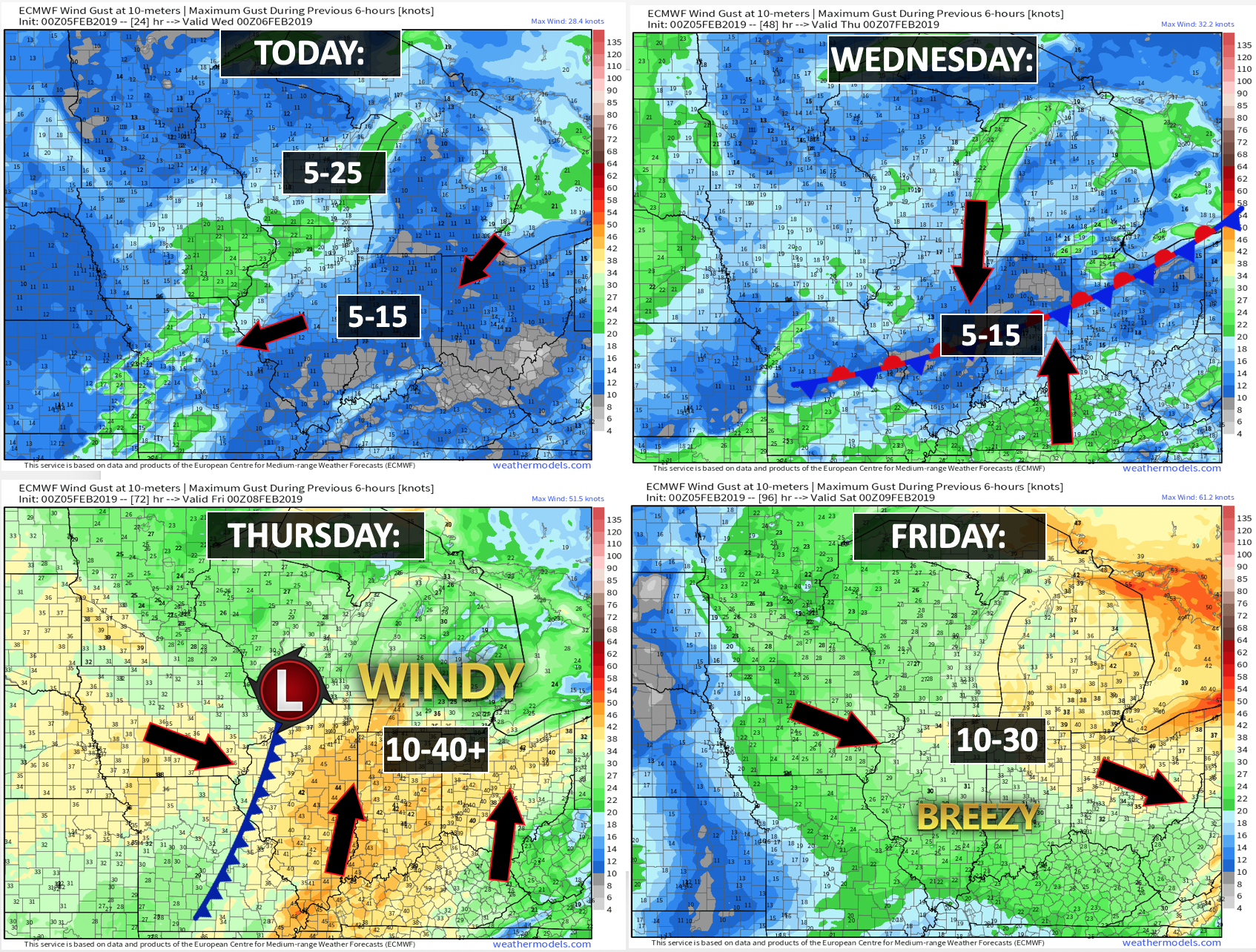

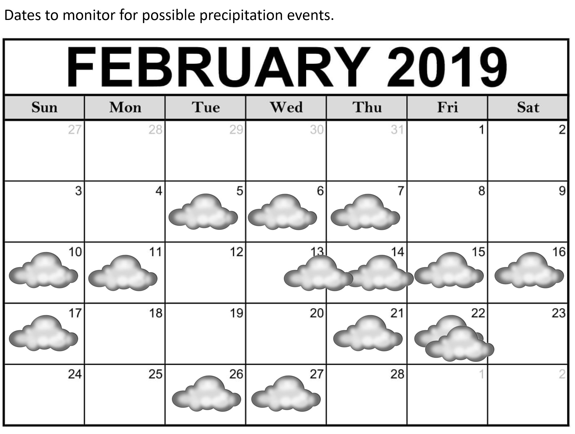
Today through Thursday: Winter weather is not anticipated.
Thursday night through Sunday: Monitor updates. Rain may end as light snow Thursday night. No accumulation, if it occurs at all. I am also watching late Saturday night into Sunday morning. We could have some additional precipitation. Perhaps a wintry mix changing to all rain.
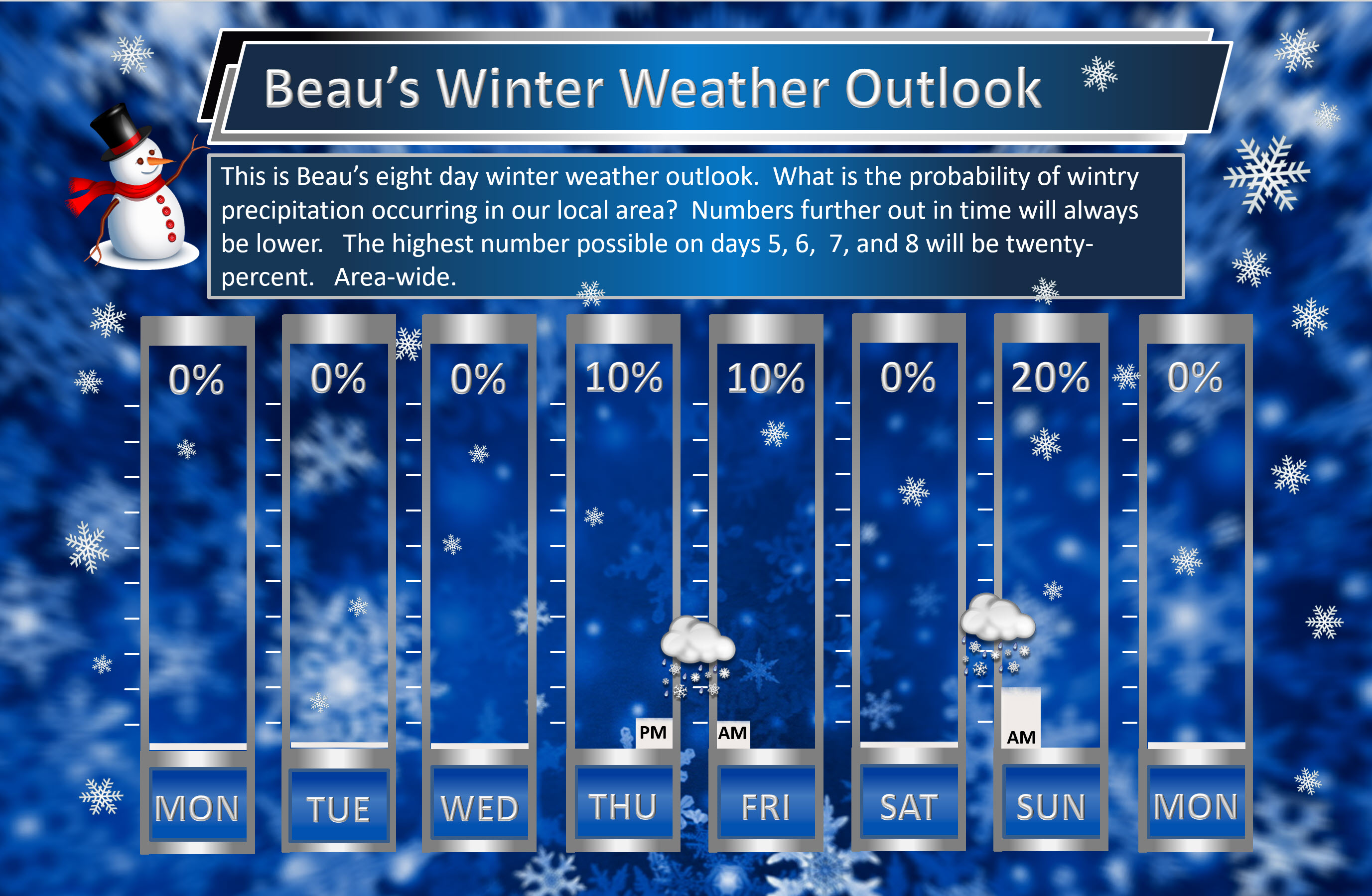
Beau’s exclusive eight-day winter weather outlook!
The highest number possible on days 5, 6, 7, and 8 will be twenty-percent.
Daily outlook:

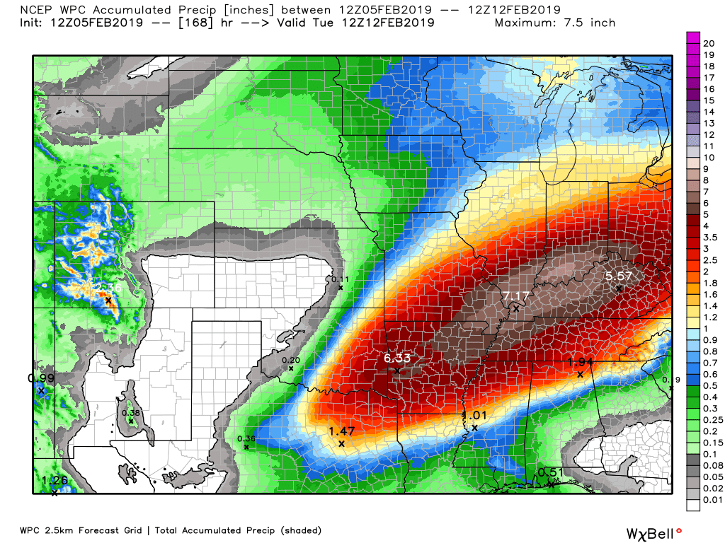
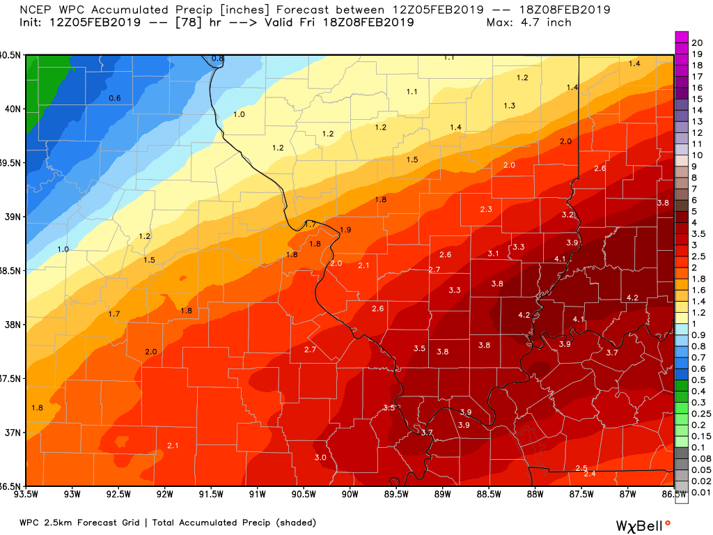
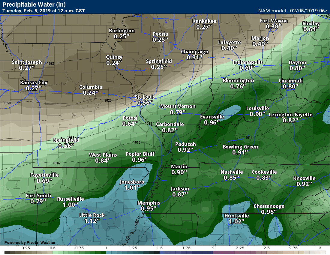
Here is the latest graphic from the WPC/NOAA.
This map shows you liquid and does not assume precipitation type. In other words, melted precipitation totals.
Locally heavy rain is possible Wednesday into Thursday evening.
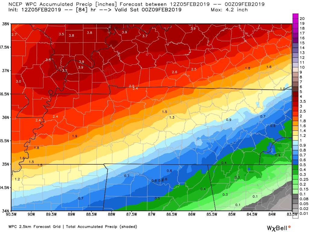
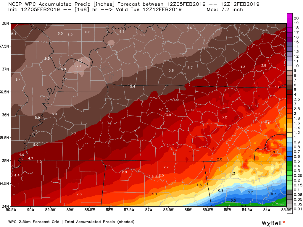
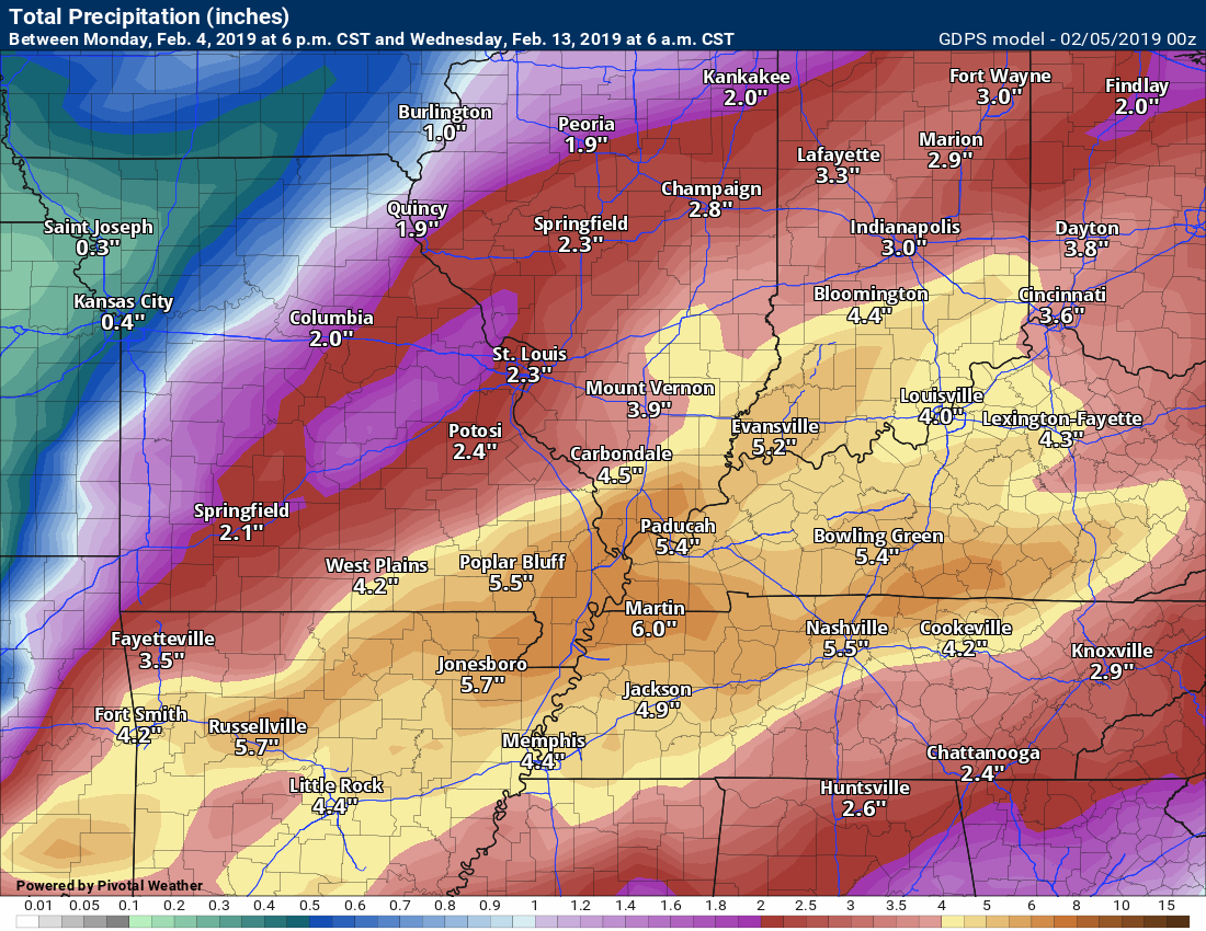
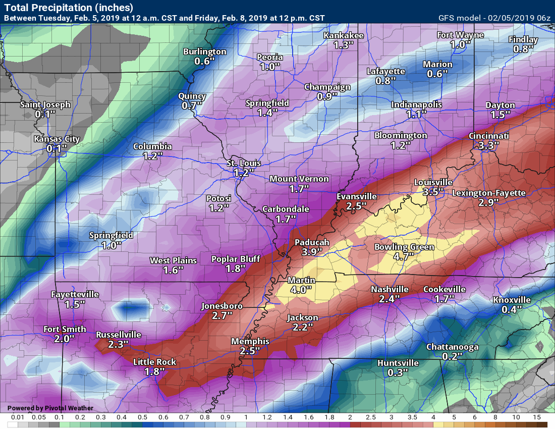
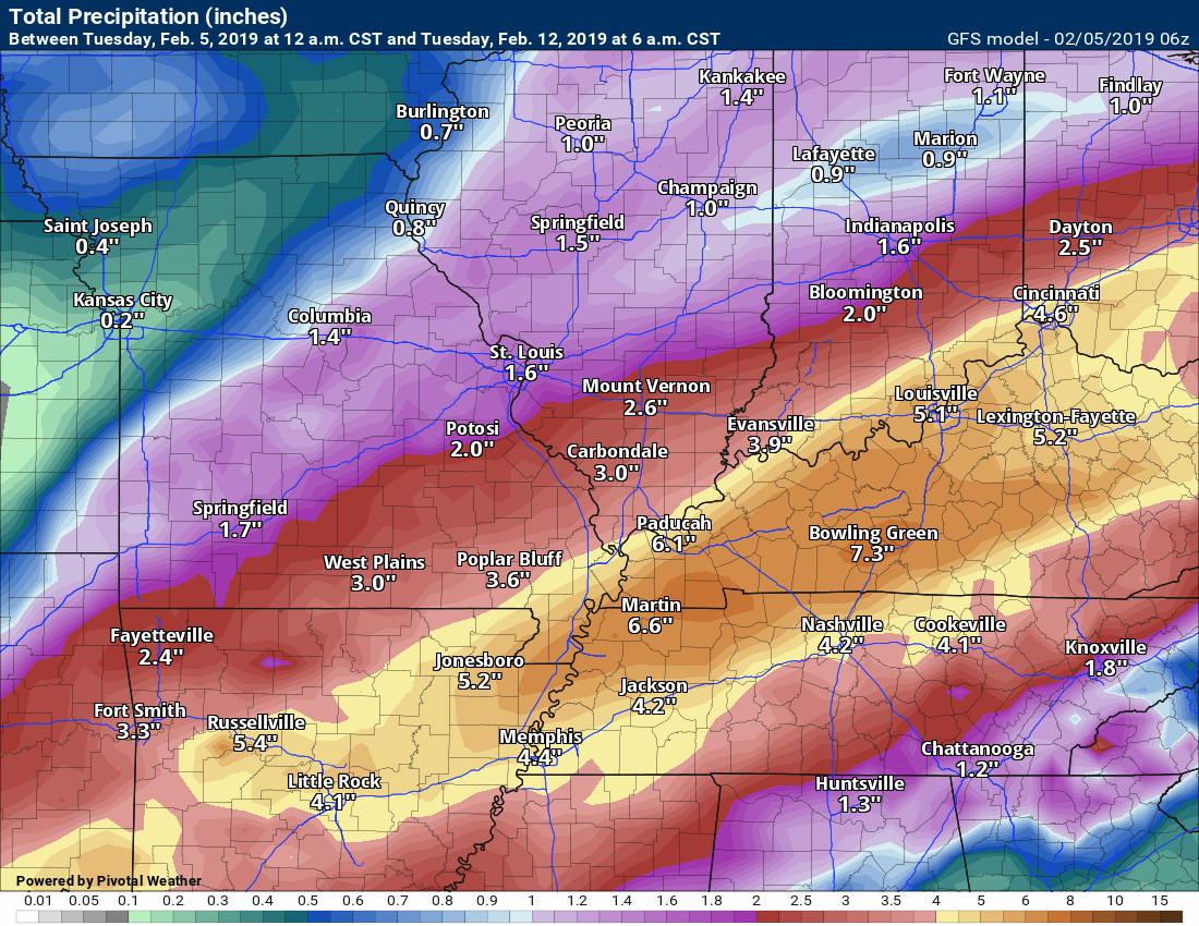
This is the seven-day image. This includes two events.
Northwest view
This is for event number one. This takes us into Friday morning.
When you add in the other event (later this weekend) you end up with some big totals.
Let’s hope this does not verify.
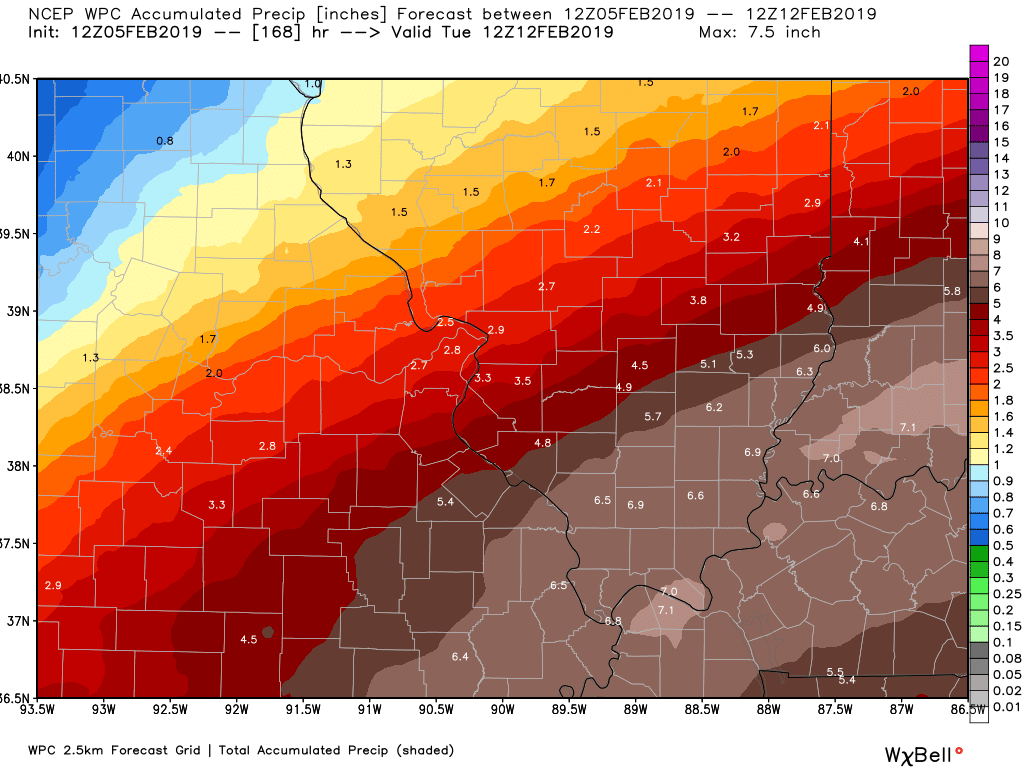
Southeast view
This is now through Friday. Most of this occurs from Wednesday into Thursday.
and the seven-day outlook (both events combined)
Subscribers, do you need a forecast for an outdoor event?

Did you know that you can find me on Twitter?


Click here for your interactive local city-view radars & regional radars.
During winter weather be sure and click the winterize button above each city-view radar. This will show you the precipitation type.

The National Weather Service defines a severe thunderstorm as one that produces quarter size hail or larger, 58 mph winds or greater, and/or a tornado.
Today through tonight: No severe weather concerns. A few reports of lightning possible this afternoon and tonight.
Wednesday into Thursday: Monitor updates. Lightning is possible. I am monitoring the risk of strong thunderstorms from Wednesday afternoon and Wednesday night. Confidence in severe weather occurring is low.
Thursday night into Monday: No severe weather concerns.
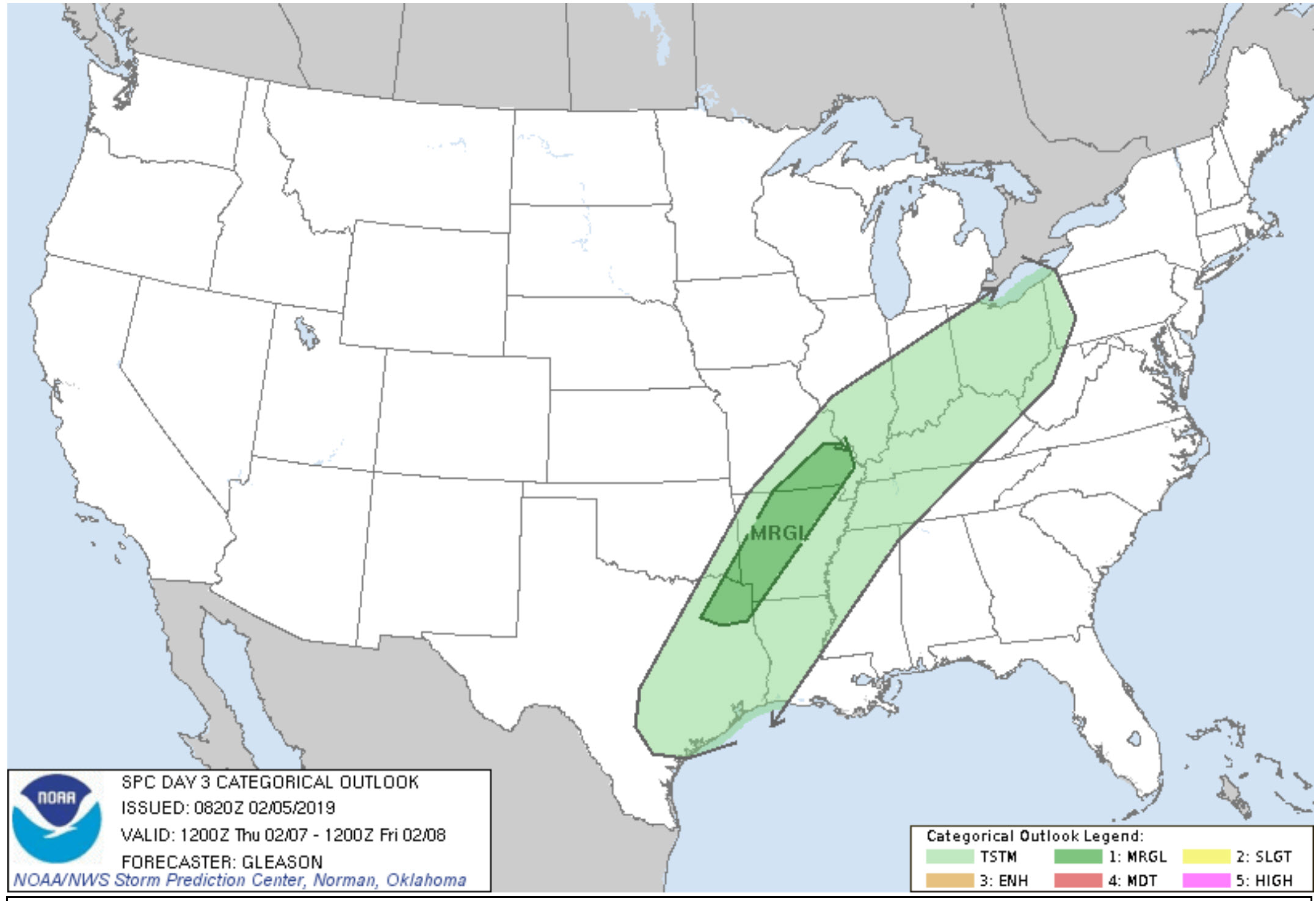
Here is the SPC outlook for tomorrow and Thursday.
Light green represents non-severe storms.
Dark green represents a marginal (level one out of five) risk.
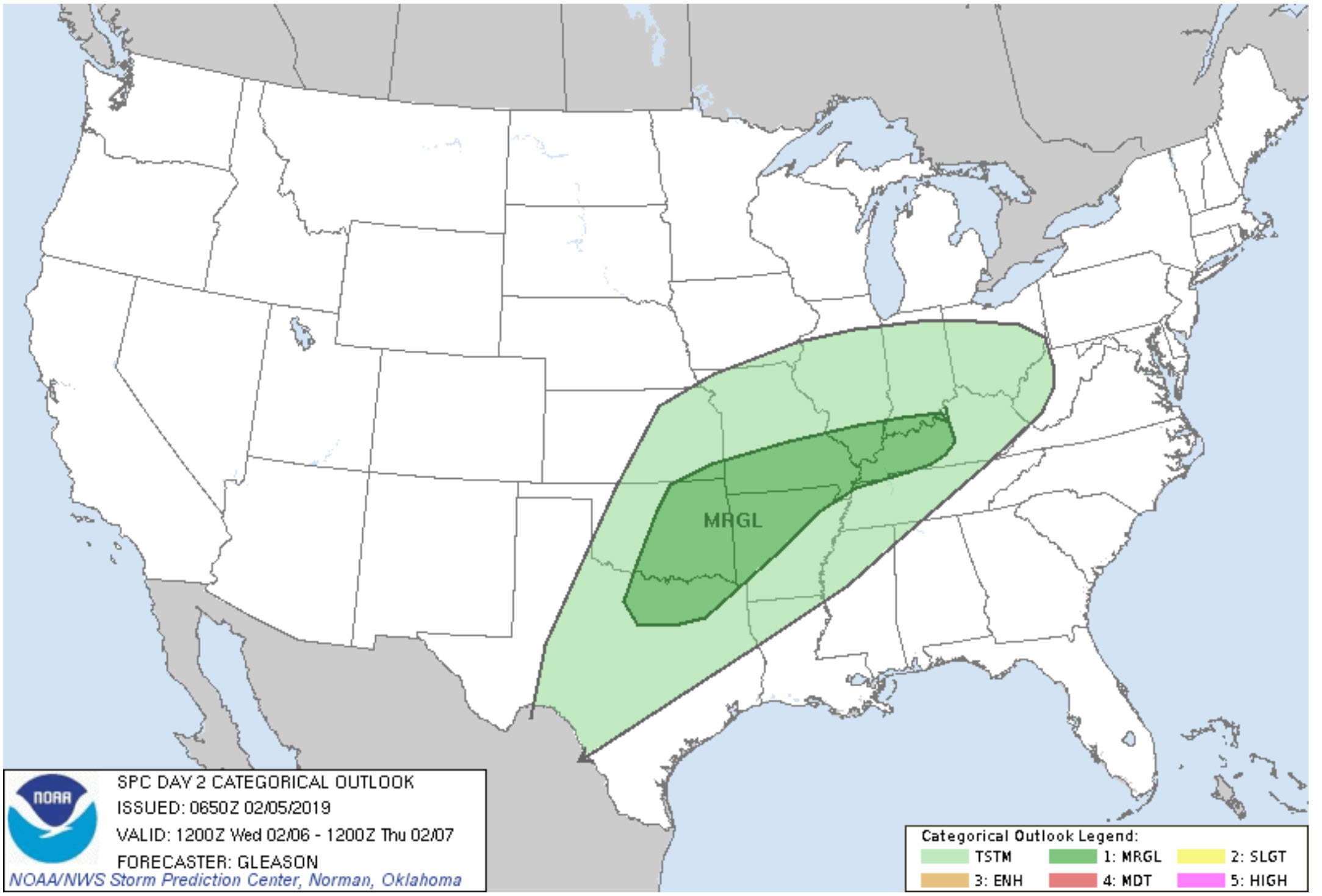
And Thursday
Interactive live weather radar page. Choose the city nearest your location. If one of the cities does not work then try a nearby one. Click here.
National map of weather watches and warnings. Click here.
Storm Prediction Center. Click here.
Weather Prediction Center. Click here.

Live lightning data: Click here.

Interactive GOES R satellite. Track clouds. Click here.

Here are the latest local river stage forecast numbers Click Here.
Here are the latest lake stage forecast numbers for Kentucky Lake and Lake Barkley Click Here.


- Widespread rain will develop over the next three days. Some thunderstorms, as well.
- Concerns about flash flooding and river flooding are increasing. Flash flood and/or flood watches will likely be issued for portions of the region later this week.
Changes over the last 24 hours.
No major adjustments. I did add a chance of thunder into the afternoon forecast. Many areas may remain mostly dry today.
Confidence in the forecast
Overall confidence in today’s forecast through Monday is medium to high.
Action?
Monitor updates. Flash flood or flood watches may need to be issued for portions of the region by Wednesday into Thursday evening.
A few severe thunderstorms can’t be ruled out. The main concern will be Wednesday afternoon and Wednesday night. Smaller risk on Thursday.
The heaviest rain will occur Wednesday night and Thursday.
Forecast Analysis and Numerical Model Guidance
As mentioned, my main weather concern centers around the heavy rain event that is developing.
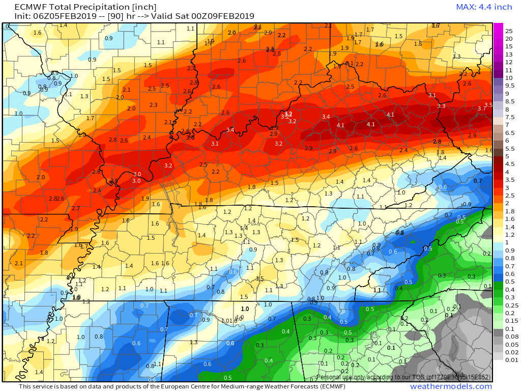
Over the next seven days, portions of the region may receive more than five inches of rain. Needless to say, we do not need all of this rain.
Some of the guidance even indicates five to eight inches of rain along the Ohio River.
You can expect significant rises on area streams and lakes.
Thunderstorms are possible over the coming days, as well. Those thunderstorms will enhance rain totals. Thunderstorms will increase the risk of flooding.
General flooding can be expected as ditches, streams, and rivers rise. Avoid flooded roadways.
The heaviest rain will arrive Wednesday night into Thursday. We also have another rain event that will develop Sunday and Monday. That could begin as a wintry mix before changing to all rain.
We also have a risk of a few severe thunderstorms Wednesday afternoon and Wednesday night. There will be plenty of clouds and ongoing rain. There remain questions about just how unstable the atmosphere will become. It is possible that no severe weather develops. This is a portion of the forecast that I will be monitoring.
Of course, I will be updating the blog, Facebook, and I will send out app messages.
Make sure you have WeatherOne turned on. That is the most important app/text message. That is the one for tornadoes.
Log into your www.weathertalk.com account. Click the personal notification settings tab. Turn on WeatherOne. It will be green if it is on. It will be red if it is off.

A few showers are also possible today. Many areas will remain cloudy and dry. There will be just enough instability to cause a few flashes of lightning, as well.
We have a front dividing the region. Temperatures will remain in the 40’s over the northern half of the region and jump to 60 degrees from the Missouri Bootheel along the Kentucky/Tennessee border.
That front will push northward tonight. That will spread warm and moist air back into the entire region. Unseasonably mild air.
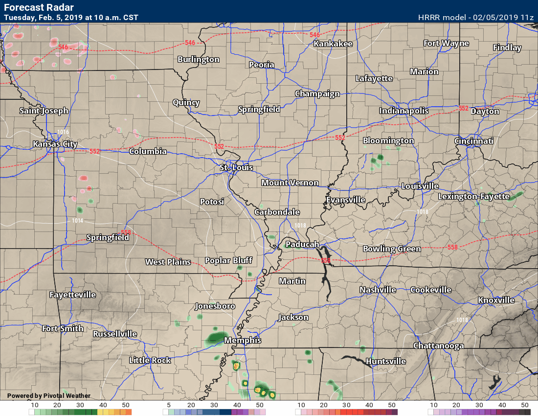
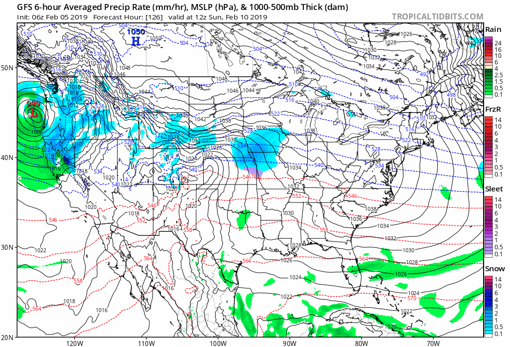
You can see some spotty showers here on the Hrrr future-cast radar model guidance.
The timestamp is located in the upper left portion of the animation. See our local city-view radars for live data. Click here for your interactive local city-view radars & regional radars.
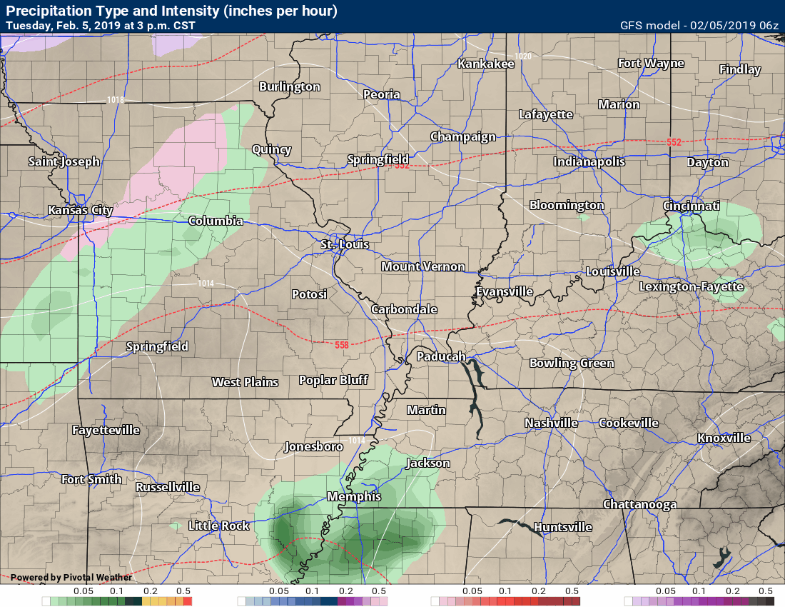
You can see a few little showers dotting radar today. Patchy fog and drizzle north of the front will also occur.
Green is rain. Yellow represents moderate rain.
The splashes of red represent freezing rain. Locally, we will not have to worry about freezing rain. It will be too warm.
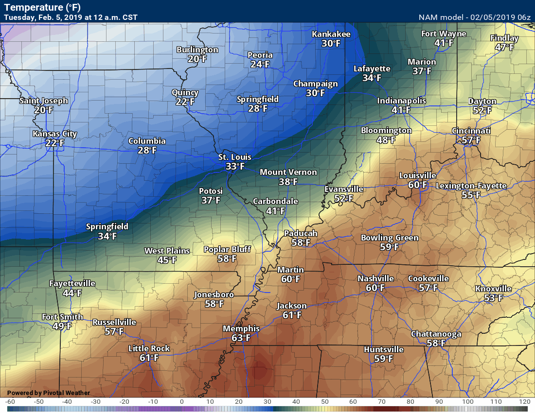
February was forecast to be a roller-coaster ride in the temperature department. We have large temperature swings ahead of us, as well.
The timestamp is located in the upper left portion of the animation.
A large spread of temperatures across the region today.
There is a front in there!
Widespread rain will develop tonight and continue into Wednesday, Wednesday night, and Thursday.
Rain will end Thursday night. I can’t rule out the rain ending as snow. At this time, accumulation appears unlikely.
Let’s look at some more future-cast radar images.
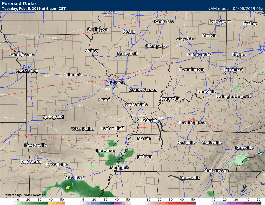
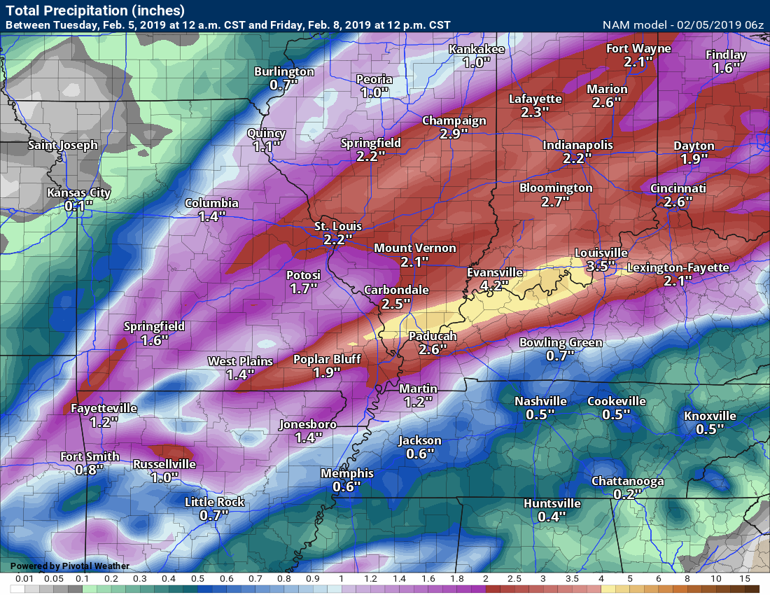
This is the NAM model guidance.
Again, the timestamp is located in the upper left.
The colors represent precipitation.
Red is freezing rain. Purple is sleet. Blue is snow.
Green is rain. Yellow and orange are moderate to heavy rain.
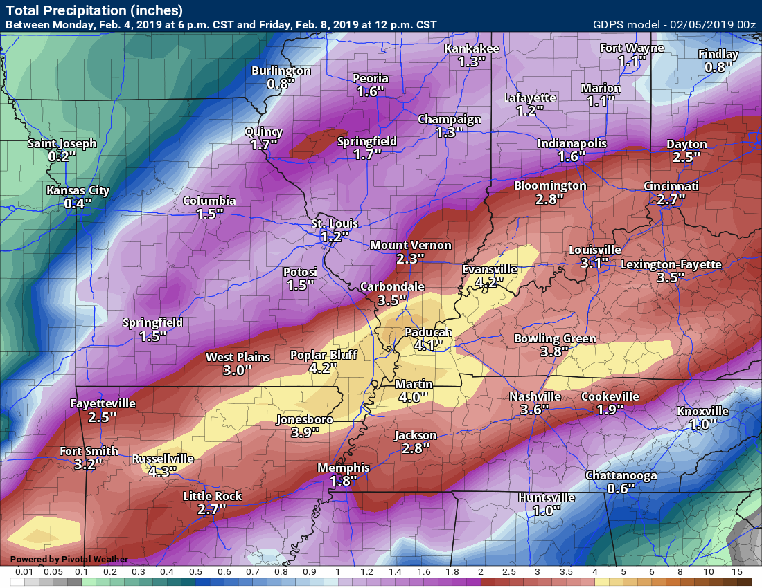
This is the GFS model guidance.
Now, let’s look at model guidance rain totals.
Don’t take the specifics from these maps. Take the general idea of placement of the heaviest rain bands.
Almost all of the models show the heaviest rain along the Ohio River.
EC model guidance
Click to enlarge images.
The NAM model guidance
Canadian
Canadian both events (the one this week and the one Sunday onward)
GFS
GFS totals from both events (the one this and the one Sunday onward)
A lot of moisture will be riding along this front. Copious amounts, as a matter of fact.
Let me show you PWAT values. These are two to three standard deviations higher than normal. Above normal PWAT values.
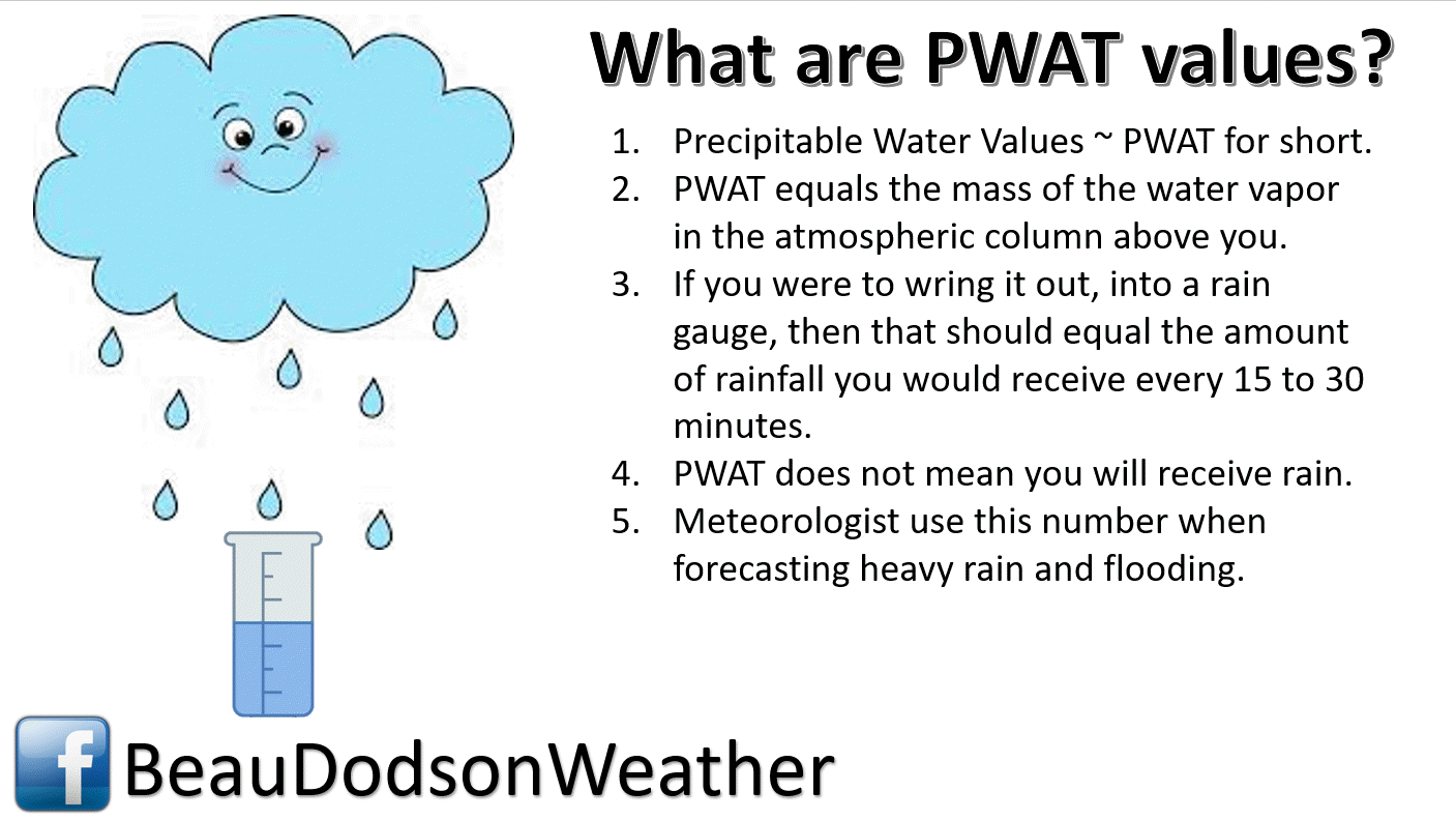
PWAT values animation
Another rain event arrives Sunday into Monday. It may begin as a wintry mix and then turn to all rain. That is the current forecast.
Satellite
Today’s image is the infrared satellite. You can see thick clouds over our region.
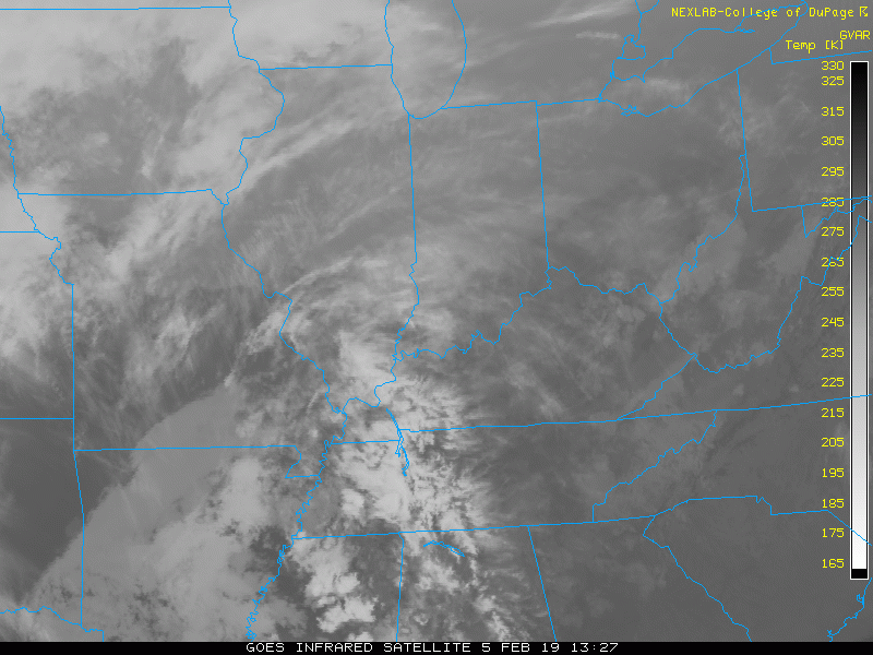
Interactive GOES R satellite. Track clouds. Click here.
Here is the latest WPC 6 to 10 and 8 to 14-day temperature outlooks.
** NOTE: See our own in-house long-range forecast graphics further down in this blog update **
Days 6 through 10
The blue colors indicate below normal temperatures. The darker the blue the greater the chance of below normal temperatures.
Waiting for this graphic to finish updating
Precipitation outlook
Waiting for this graphic to finish updating
Days 8 through 14
Waiting for this graphic to finish updating
Precipitation
Waiting for this graphic to finish updating
The February update has been posted. Temperature forecast from the long-range team.
This product is for subscribers.
Subscribe at www.weathertalk.com
SPRING OUTLOOK
Here is the preliminary March, April, and May temperature and precipitation forecast.
Temperature and precipitation outlooks
This product is for subscribers.
Subscribe at www.weathertalk.com
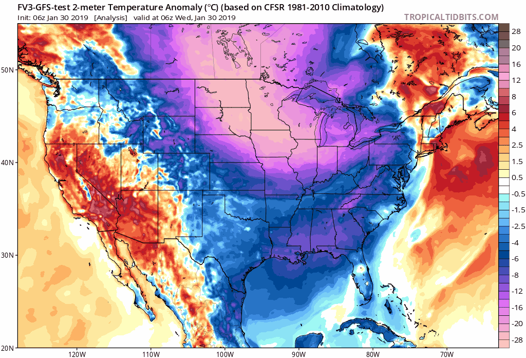
Long Range Temperature Anomaly Forecast
Let’s look at the temperature anomaly forecast map from the long-range GFS model guidance.
This graphic shows you whether temperatures are forecast to average above or below normal.
Red shades indicate above normal temperatures. Orange and red indicate much above normal temperatures.
Blue shades represent below normal temperatures. Purple to pinkish represents much below normal temperatures.
The time-stamp is located in the upper left portion of the map animation.
Click the image to enlarge it.
![]()

I bring these to you from the BAMwx team. They are excellent long-range forecasters.
Remember, long-range outlooks are a bit of skill, understanding weather patterns, and luck combined. It is not an exact science.

This product is for subscribers.
Subscribe at www.weathertalk.com
Subscriber graphics can be viewed on this page CLICK HERE

This product is for subscribers.

This product is for subscribers.
Subscribe at www.weathertalk.com
Subscriber graphics can be viewed on this page CLICK HERE
![]()
.
Winter Outlook!
These products are for subscribers.
December temperature and precipitation outlook
January temperature outlook
February temperature outlook
Winter snow outlook
.These products are for subscribers.
![]()

A new weather podcast is now available! Weather Geeks (which you might remember is on The Weather Channel each Sunday)
To learn more visit their website. Click here.
![]()

WeatherBrains Episode 680
Tonight’s Guest WeatherBrain is the teaching professor in meteorology and the associate head of the undergraduate program in meteorology at The Penn State University. He is also the host, feature writer, and producer of Weather World, Penn State Meteorology Department’s weekday weather magazine show. He also produces a segment on Wednesday’s called WeatherWhys (WxYz). In addition, he was an on-air storm analyst at The Weather Channel from 2002 to 2005 (just after Dr. John Scala was there) and was the chief meteorologist at the historic Franklin Institute Science Museum in Philadelphia from 1998 to 2002. He has also co-authored two books: “The Philadelphia Area Weather Book” and “A World of Weather: Fundamentals of Meteorology.” Dr. Jon Nese, welcome to WeatherBrains!
Other discussions in this weekly podcast include topics like:
- Winter Storm in the South
- The Franklin Institute Weather Co-Op Observing Center
- Groundhog Day upcoming on Saturday
- NWS employees struggling during the government shutdown
- The Astronomy Report from Tony Rice
- and more.
.
.
Link to their website https://weatherbrains.com/
Previous episodes can be viewed by clicking here.

We offer interactive local city live radars and regional radars. If a radar does not update then try another one. If a radar does not appear to be refreshing then hit Ctrl F5. You may also try restarting your browser.
The local city view radars also have clickable warnings.
During the winter months, you can track snow and ice by clicking the winterize button on the local city view interactive radars.
You may email me at beaudodson@usawx.com
Find me on Facebook!

Find me on Twitter!

Did you know that a portion of your monthly subscription helps support local charity projects?
You can learn more about those projects by visiting the Shadow Angel Foundation website and the Beau Dodson News website.

I encourage subscribers to use the app vs regular text messaging. We have found text messaging to be delayed during severe weather. The app typically will receive the messages instantly. I recommend people have three to four methods of receiving their severe weather information.
Remember, my app and text alerts are hand typed and not computer generated. You are being given personal attention during significant weather events.
