![]()
February 4, 2019
Monday’s Forecast: Mostly cloudy with scattered rain showers. Warm. Windy. Spring-like temperatures.
My confidence in the forecast verifying: Medium (60% confidence in the forecast)
Temperature range: MO Bootheel 63° to 66° SE MO 63° to 66° South IL 63° to 66° West KY 63° to 66° NW TN 64° to 66°
Wind direction and speed: South and southwest at 10 to 20 mph and gusty
Wind chill or heat index (feels like) temperature forecast:
What is the chance/probability of precipitation? MO Bootheel 40% MO 40% IL 40% KY 50% TN 50%
Note, what does the % chance actually mean? A 20% chance of rain does not mean it won’t rain. It simply means most areas will remain dry.
Coverage of precipitation: Scattered
Is flash flooding anticipated? No
Will there be accumulating snow or ice? No
Will non-accumulating snow or ice occur? No
Are icy road conditions anticipated? No
Is severe weather expected? N0
The NWS officially defines severe weather as 58 mph wind or great, 1″ hail or larger, and/or tornadoes
Is lightning anticipated? No
What impacts are anticipated from the weather? Wet roadways. Gusty winds.
Should I cancel my outdoor plans? No, but monitor radars. Some rain showers are possible.
UV Index: 1 Low
Sunrise: 6:56 AM
Monday night Forecast: Cloudy with some rain showers.
My confidence in the forecast verifying: Medium (60% confidence in the forecast)
Temperature range: MO Bootheel 46° to 50° SE MO 38° to 46° South IL 36° to 42° West KY 45° to 50° NW TN 48° to 52°
Wind direction and speed: West and southwest at 6 to 12 mph
Wind chill or heat index (feels like) temperature forecast:
What is the chance/probability of precipitation? MO Bootheel 40% MO 40% IL 40% KY 40% TN 40%
Note, what does the % chance actually mean? A 20% chance of rain does not mean it won’t rain. It simply means most areas will remain dry
Coverage of precipitation: Scattered
Is flash flooding anticipated? No
Will there be accumulating snow or ice? No
Will non-accumulating snow or ice occur? No
Are icy road conditions anticipated? No
Is severe weather expected? Not at this time
The NWS officially defines severe weather as 58 mph wind or great, 1″ hail or larger, and/or tornadoes
Is lightning anticipated? No
What impacts are anticipated from the weather? Wet roadways possible.
Should I cancel my outdoor plans? No, but monitor updates. Rain is certainly a possibility and this could impact outdoor activities.
Sunset: 5:23 PM
Moonrise: 6:56 AM
The phase of the moon: New
Moonset: 5:19 PM
February 5, 2019
Tuesday’s Forecast: Partly cloudy. A bit cooler.
My confidence in the forecast verifying: Medium (60% confidence in the forecast)
Temperature range: MO Bootheel 50° to 54° SE MO 48° to 54° South IL 48° to 54° West KY 50° to 54° NW TN 50° to 54°
Wind direction and speed: East and southeast at 7 to 14 mph
Wind chill or heat index (feels like) temperature forecast:
What is the chance/probability of precipitation? MO Bootheel 0% MO 0% IL 0% KY 0% TN 0%
Note, what does the % chance actually mean? A 20% chance of rain does not mean it won’t rain. It simply means most areas will remain dry.
Coverage of precipitation: None
Is flash flooding anticipated? No
Will there be accumulating snow or ice? No
Will non-accumulating snow or ice occur? No
Are icy road conditions anticipated? No
Is severe weather expected? No
The NWS officially defines severe weather as 58 mph wind or great, 1″ hail or larger, and/or tornadoes
Is lightning anticipated? Unlikely, but monitor updates.
What impacts are anticipated from the weather? None
Should I cancel my outdoor plans? No
UV Index: 2 Low
Sunrise: 6:55 AM
Tuesday night Forecast: Partly cloudy. Mild.
My confidence in the forecast verifying: Medium (60% confidence in the forecast)
Temperature range: MO Bootheel 50° to 54° SE MO 50° to 54° South IL 50° to 54° West KY 50° to 54° NW TN 50° to 54°
Wind direction and speed: South winds at 7 to 14 mph
Wind chill or heat index (feels like) temperature forecast:
What is the chance/probability of precipitation? MO Bootheel 0% MO 0% IL 0% KY 0% TN 0%
Note, what does the % chance actually mean? A 20% chance of rain does not mean it won’t rain. It simply means most areas will remain dry
Coverage of precipitation: None
Is flash flooding anticipated? No
Will there be accumulating snow or ice? No
Will non-accumulating snow or ice occur? No
Are icy road conditions anticipated? No
Is severe weather expected? No
The NWS officially defines severe weather as 58 mph wind or great, 1″ hail or larger, and/or tornadoes
Is lightning anticipated? No
What impacts are anticipated from the weather? None
Should I cancel my outdoor plans? No
Sunset: 5:24 PM
Moonrise: 7:32 AM
The phase of the moon: New
Moonset: 6:14 PM
February 6, 2019
Wednesday’s Forecast: Cloudy with rain showers possible.
My confidence in the forecast verifying: Medium (50% confidence in the forecast)
Temperature range: MO Bootheel 60° to 64° SE MO 58° to 62° South IL 58° to 62° West KY 58° to 62° NW TN 60° to 64°
Wind direction and speed:
Wind chill or heat index (feels like) temperature forecast:
What is the chance/probability of precipitation? MO Bootheel 50% MO 50% IL 50% KY 50% TN 50%
Note, what does the % chance actually mean? A 20% chance of rain does not mean it won’t rain. It simply means most areas will remain dry.
Coverage of precipitation: Scattered
Is flash flooding anticipated? No
Will there be accumulating snow or ice? No
Will non-accumulating snow or ice occur? No
Are icy road conditions anticipated? No
Is severe weather expected? No
The NWS officially defines severe weather as 58 mph wind or great, 1″ hail or larger, and/or tornadoes
Is lightning anticipated? Possible.
What impacts are anticipated from the weather? Wet roadways.
Should I cancel my outdoor plans? Monitor updates.
UV Index: 1 Low
Sunrise: 6:54 AM
Wednesday night Forecast: Rain likely. Thunderstorms are possible. Locally heavy rain.
My confidence in the forecast verifying: Medium (60% confidence in the forecast)
Temperature range: MO Bootheel 55° to 60° SE MO 55° to 60° South IL 55° to 60° West KY 55° to 60° NW TN 55° to 60°
Wind direction and speed:
Wind chill or heat index (feels like) temperature forecast:
What is the chance/probability of precipitation? MO Bootheel 60% MO 60% IL 60% KY 60% TN 60%
Note, what does the % chance actually mean? A 20% chance of rain does not mean it won’t rain. It simply means most areas will remain dry
Coverage of precipitation: Numerous
Is flash flooding anticipated? Possible.
Will there be accumulating snow or ice? No
Will non-accumulating snow or ice occur? No
Are icy road conditions anticipated? No
Is severe weather expected? Monitor updates.
The NWS officially defines severe weather as 58 mph wind or great, 1″ hail or larger, and/or tornadoes
Is lightning anticipated? Yes
What impacts are anticipated from the weather? Heavy rain. Lightning. Gusty winds. Monitor severe weather concerns.
Should I cancel my outdoor plans? Have a plan B.
Sunset: 5:25 PM
Moonrise: 8:05 AM
The phase of the moon: Waxing Crescent
Moonset: 7:11 PM
February 7, 2019
Thursday’s Forecast: Showers and possible thunderstorms. Heavy rain is possible.
My confidence in the forecast verifying: Medium (59% confidence in the forecast)
Temperature range: MO Bootheel 58° to 62° SE MO 58° to 62° South IL 55° to 60° West KY 56° to 62° NW TN 60° to 64°
Wind direction and speed:
Wind chill or heat index (feels like) temperature forecast:
What is the chance/probability of precipitation? MO Bootheel 70% MO 70% IL 70% KY 70% TN 70%
Note, what does the % chance actually mean? A 20% chance of rain does not mean it won’t rain. It simply means most areas will remain dry.
Coverage of precipitation: Numerous
Is flash flooding anticipated? Possible
Will there be accumulating snow or ice? No
Will non-accumulating snow or ice occur? No
Are icy road conditions anticipated? No
Is severe weather expected? Monitor updates
The NWS officially defines severe weather as 58 mph wind or great, 1″ hail or larger, and/or tornadoes
Is lightning anticipated? Yes
What impacts are anticipated from the weather? Heavy rain. Flooding or flash flooding. Lightning. Gusty winds. Monitor the threat of severe weather.
Should I cancel my outdoor plans? Have a plan B.
UV Index: 1 Low
Sunrise: 6:53 AM
Thursday night Forecast: Mostly cloudy rain or snow showers.
My confidence in the forecast verifying: Low (30% confidence in the forecast)
Temperature range: MO Bootheel 23° to 26° SE MO 20° to 25° South IL 20° to 25° West KY 22° to 24° NW TN 23° to 26°
Wind direction and speed:
Wind chill or heat index (feels like) temperature forecast: 15 to 20
What is the chance/probability of precipitation? MO Bootheel 40% MO 40% IL 40% KY 40% TN 40%
Note, what does the % chance actually mean? A 20% chance of rain does not mean it won’t rain. It simply means most areas will remain dry
Coverage of precipitation: Scattered to numerous early. Ending west to east.
Is flash flooding anticipated? Monitor
Will there be accumulating snow or ice? Monitor
Will non-accumulating snow or ice occur? Possible
Are icy road conditions anticipated? Monitor
Is severe weather expected? No
The NWS officially defines severe weather as 58 mph wind or great, 1″ hail or larger, and/or tornadoes
Is lightning anticipated? No
What impacts are anticipated from the weather? Wet roadways. Monitor snow chances.
Should I cancel my outdoor plans? Monitor updates
Sunset: 5:26 PM
Moonrise: 8:35 AM
The phase of the moon: Waxing Crescent
Moonset: 8:07 PM
![]()
February 8, 2019
Friday’s Forecast: Mostly sunny and cool.
My confidence in the forecast verifying: Medium (60% confidence in the forecast)
Temperature range: MO Bootheel 34° to 36° SE MO 32° to 34° South IL 30° to 34° West KY 32° to 36° NW TN 34° to 36°
Wind direction and speed:
Wind chill or heat index (feels like) temperature forecast:
What is the chance/probability of precipitation? MO Bootheel 0% MO 0% IL 0% KY 0% TN 0%
Note, what does the % chance actually mean? A 20% chance of rain does not mean it won’t rain. It simply means most areas will remain dry.
Coverage of precipitation: None
Is flash flooding anticipated? No
Will there be accumulating snow or ice? No
Will non-accumulating snow or ice occur? No
Are icy road conditions anticipated? No
Is severe weather expected? No
The NWS officially defines severe weather as 58 mph wind or great, 1″ hail or larger, and/or tornadoes
Is lightning anticipated? No
What impacts are anticipated from the weather? None
Should I cancel my outdoor plans? No
UV Index: 3 Moderate
Sunrise: 6:52 AM
Friday night Forecast: Mostly clear and cold.
My confidence in the forecast verifying: Medium (40% confidence in the forecast)
Temperature range: MO Bootheel 23° to 26° SE MO 20° to 25° South IL 20° to 25° West KY 22° to 24° NW TN 23° to 26°
Wind direction and speed:
Wind chill or heat index (feels like) temperature forecast: 15 to 20
What is the chance/probability of precipitation? MO Bootheel 0% MO 0% IL 0% KY 0% TN 0%
Note, what does the % chance actually mean? A 20% chance of rain does not mean it won’t rain. It simply means most areas will remain dry
Coverage of precipitation: None
Is flash flooding anticipated? No
Will there be accumulating snow or ice? No
Will non-accumulating snow or ice occur? No
Are icy road conditions anticipated? No
Is severe weather expected? No
The NWS officially defines severe weather as 58 mph wind or great, 1″ hail or larger, and/or tornadoes
Is lightning anticipated? No
What impacts are anticipated from the weather? None
Should I cancel my outdoor plans? No
Sunset: 5:27 PM
Moonrise: 9:03 AM
The phase of the moon: Waxing Crescent
Moonset: 9:03 PM
February 9, 2019
Saturday’s Forecast: Partly sunny.
My confidence in the forecast verifying: Medium (50% confidence in the forecast)
Temperature range: MO Bootheel 42° to 44° SE MO 38° to 44° South IL 38° to 44° West KY 38° to 44° NW TN 42° to 44°
Wind direction and speed:
Wind chill or heat index (feels like) temperature forecast:
What is the chance/probability of precipitation? MO Bootheel 0% MO 0% IL 0% KY 0% TN 0%
Note, what does the % chance actually mean? A 20% chance of rain does not mean it won’t rain. It simply means most areas will remain dry.
Coverage of precipitation: None
Is flash flooding anticipated? No
Will there be accumulating snow or ice? No
Will non-accumulating snow or ice occur? No
Are icy road conditions anticipated? No
Is severe weather expected? No
The NWS officially defines severe weather as 58 mph wind or great, 1″ hail or larger, and/or tornadoes
Is lightning anticipated? No
What impacts are anticipated from the weather? None
Should I cancel my outdoor plans? No
UV Index: 3 Moderate
Sunrise: 6:51 AM
Saturday night Forecast: Partly cloudy. and chilly.
My confidence in the forecast verifying: Medium (40% confidence in the forecast)
Temperature range: MO Bootheel 32° to 34° SE MO 30° to 35° South IL 30° to 35° West KY 32° to 34° NW TN 34° to 36
Wind direction and speed:
Wind chill or heat index (feels like) temperature forecast: 30 to 40
What is the chance/probability of precipitation? MO Bootheel 0% MO 0% IL 0% KY 0% TN 0%
Note, what does the % chance actually mean? A 20% chance of rain does not mean it won’t rain. It simply means most areas will remain dry
Coverage of precipitation: None
Is flash flooding anticipated? No
Will there be accumulating snow or ice? No
Will non-accumulating snow or ice occur? No
Are icy road conditions anticipated? No
Is severe weather expected? No
The NWS officially defines severe weather as 58 mph wind or great, 1″ hail or larger, and/or tornadoes
Is lightning anticipated? No
What impacts are anticipated from the weather? None
Should I cancel my outdoor plans? No
Sunset: 5:28 PM
Moonrise: 9:32 AM
The phase of the moon: Waxing Crescent
Moonset: 10:00 PM
February 10, 2019
Sunday’s Forecast:
My confidence in the forecast verifying: Medium (50% confidence in the forecast)
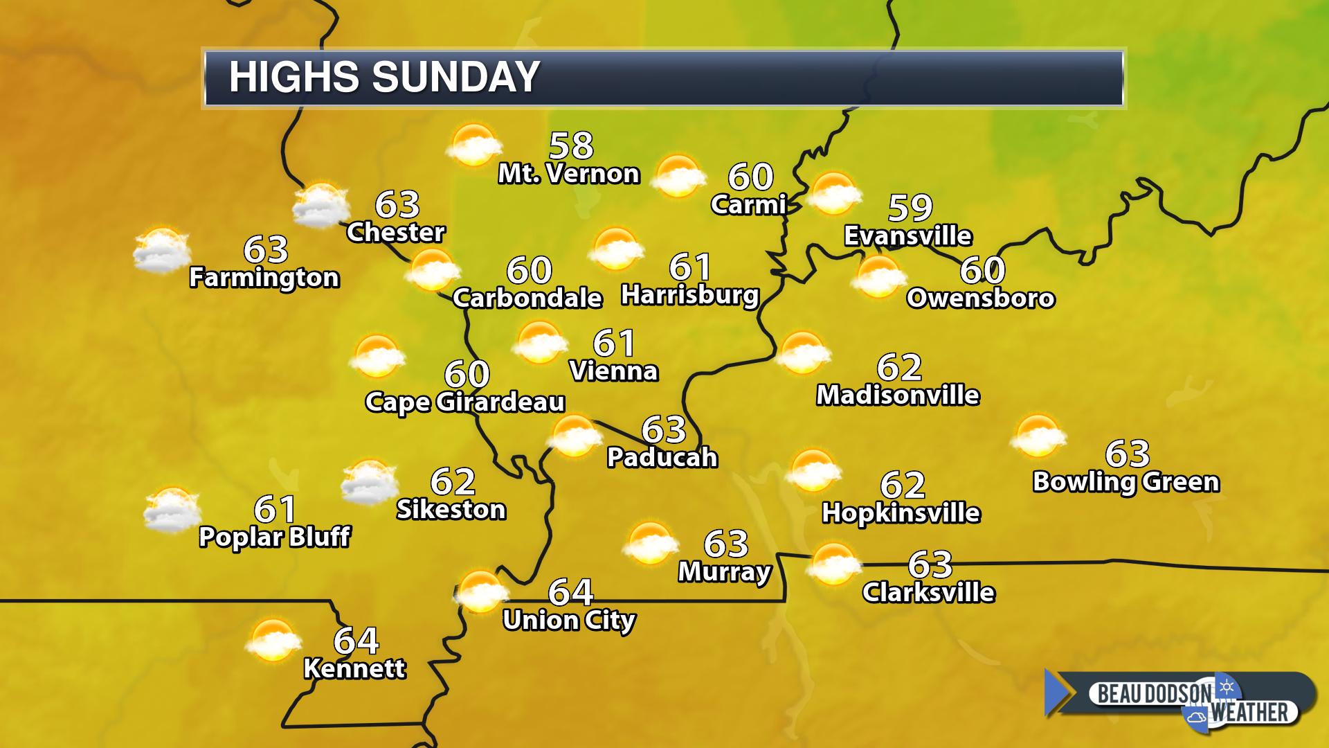
Temperature range: MO Bootheel 58° to 62° SE MO 53° to 56° South IL 53° to 56° West KY 56° to 60° NW TN 58° to 62°
Wind direction and speed:
Wind chill or heat index (feels like) temperature forecast:
What is the chance/probability of precipitation? MO Bootheel 0% MO 0% IL 0% KY 0% TN 0%
Note, what does the % chance actually mean? A 20% chance of rain does not mean it won’t rain. It simply means most areas will remain dry.
Coverage of precipitation:
Is flash flooding anticipated? No
Will there be accumulating snow or ice? No
Will non-accumulating snow or ice occur? No
Are icy road conditions anticipated? No
Is severe weather expected? No
The NWS officially defines severe weather as 58 mph wind or great, 1″ hail or larger, and/or tornadoes
Is lightning anticipated?
What impacts are anticipated from the weather?
Should I cancel my outdoor plans?
UV Index: 1 Low
Sunrise: 6:50 AM
Sunday night Forecast: Cloudy with scattered showers again possible.
My confidence in the forecast verifying: Low (30% confidence in the forecast)
Temperature range: MO Bootheel 44° to 48° SE MO 40° to 45° South IL 40° to 44° West KY 43° to 44° NW TN 43° to 46°
Wind direction and speed:
Wind chill or heat index (feels like) temperature forecast:
What is the chance/probability of precipitation? MO Bootheel 30% MO 30% IL 30% KY 30% TN 30%
Note, what does the % chance actually mean? A 20% chance of rain does not mean it won’t rain. It simply means most areas will remain dry
Coverage of precipitation: Scattered
Is flash flooding anticipated? No
Will there be accumulating snow or ice? No
Will non-accumulating snow or ice occur? No
Are icy road conditions anticipated? No
Is severe weather expected? No
The NWS officially defines severe weather as 58 mph wind or great, 1″ hail or larger, and/or tornadoes
Is lightning anticipated? No
What impacts are anticipated from the weather? Wet roadways.
Should I cancel my outdoor plans? Not at this time. Monitor updates.
Sunset: 6:50 PM
Moonrise: 10:00 AM
The phase of the moon: Waxing Crescent
Moonset: 10:58 PM
February 11, 2019
Monday’s Forecast: Cloudy with a chance of showers.
My confidence in the forecast verifying: Low (30% confidence in the forecast)
Temperature range: MO Bootheel 45° to 50° SE MO 44° to 48° South IL 44° to 48° West KY 46° to 50° NW TN 46° to 52°
Wind direction and speed:
Wind chill or heat index (feels like) temperature forecast:
What is the chance/probability of precipitation? MO Bootheel 30% MO 30% IL 30% KY 30% TN 30%
Note, what does the % chance actually mean? A 20% chance of rain does not mean it won’t rain. It simply means most areas will remain dry.
Coverage of precipitation: Scattered
Is flash flooding anticipated? No
Will there be accumulating snow or ice? No
Will non-accumulating snow or ice occur? No
Are icy road conditions anticipated? No
Is severe weather expected? No
The NWS officially defines severe weather as 58 mph wind or great, 1″ hail or larger, and/or tornadoes
Is lightning anticipated? No
What impacts are anticipated from the weather? Wet roadways.
Should I cancel my outdoor plans? No, not yet. Monitor updates.
UV Index: 1 Low
Sunrise: 6:40 AM
Monday night Forecast: Cloudy. A chance of rain showers.
My confidence in the forecast verifying: Low (30% confidence in the forecast)
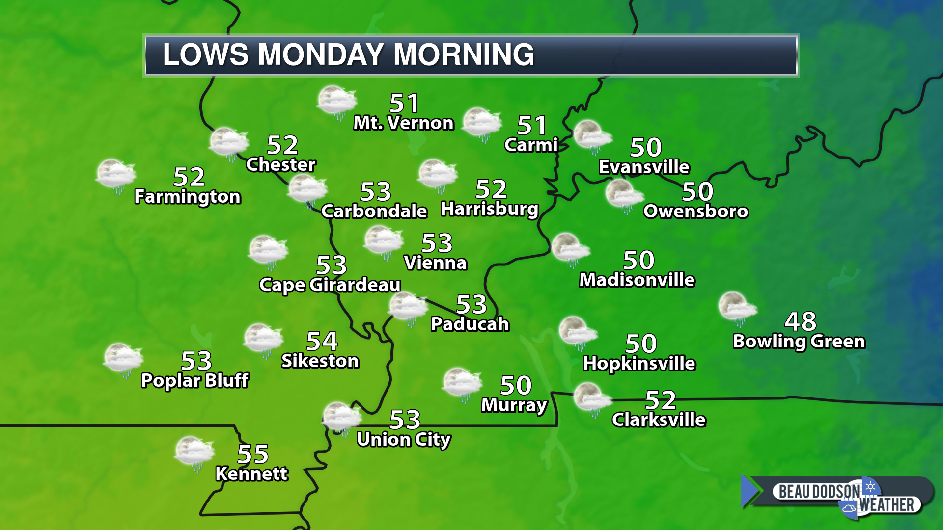
Temperature range: MO Bootheel 36° to 40° SE MO 34° to 38° South IL 34° to 38° West KY 36° to 40° NW TN 36° to 40°
Wind direction and speed:
Wind chill or heat index (feels like) temperature forecast:
What is the chance/probability of precipitation? MO Bootheel 30% MO 30% IL 30% KY 30% TN 30%
Note, what does the % chance actually mean? A 20% chance of rain does not mean it won’t rain. It simply means most areas will remain dry
Coverage of precipitation: Scattered
Is flash flooding anticipated? No
Will there be accumulating snow or ice? No
Will non-accumulating snow or ice occur? No
Are icy road conditions anticipated? No
Is severe weather expected? No
The NWS officially defines severe weather as 58 mph wind or great, 1″ hail or larger, and/or tornadoes
Is lightning anticipated? No
What impacts are anticipated from the weather? Wet roadways. Patchy fog.
Should I cancel my outdoor plans? No, not yet. Monitor updates.
Sunset: 5:30 PM
Moonrise: 10:30 AM
The phase of the moon: Waxing Crescent
Moonset: 11:58 PM

WeatherTalk monthly operating costs can top $2000.00. Your $5 subscription helps pay for those costs. I work for you.
The $5 will allow you to register up to seven phones!
For $5 a month you can receive the following. You may choose to receive these via your WeatherTalk app or regular text messaging.
Severe weather app/text alerts from my keyboard to your app/cell phone. These are hand typed messages from me to you. During tornado outbreaks, you will receive numerous app/text messages telling you exactly where the tornado is located.
- Daily forecast app/texts from my computer to your app/cell phone.
- Social media links sent directly to your app/cell phone. When I update the blog, videos, or Facebook you will receive the link.
- AWARE emails. These emails keep you well ahead of the storm. They give you several days of lead time before significant weather events.
- Direct access to Beau via text and email. Your very own personal meteorologist. I work for you!
- Missouri and Ohio Valley centered video updates
- Long-range weather videos
- Week one, two, three and four temperature and precipitation outlooks.
Monthly outlooks. - Your subscription also will help support several local charities.
Would you like to subscribe? Subscribe at www.beaudodsonweather.com
I encourage subscribers to use the app vs regular text messaging. We have found text messaging to be delayed during severe weather. The app typically will receive the messages instantly. I recommend people have three to four methods of receiving their severe weather information.
Remember, my app and text alerts are hand typed and not computer generated. You are being given my personal attention during significant weather events.

![]()

Welcome to what we will call pre-spring!
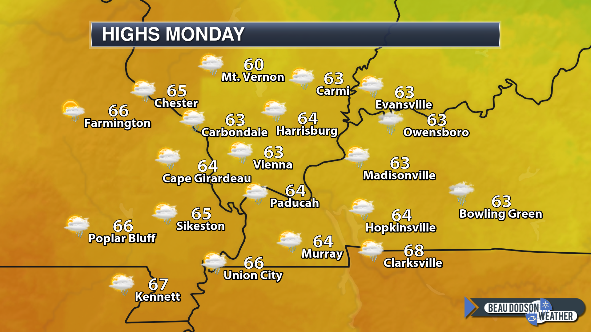
Dry today with some breezy conditions. Well above average temperatures. The well above average temperatures will continue into at least Wednesday night and perhaps Thursday.
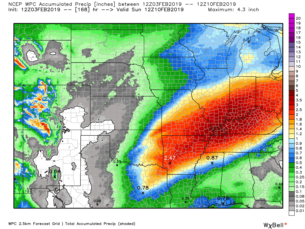
We have several rain chances. The greatest rain chances will arrive on Wednesday and Thursday.
Locally heavy rain is possible.
There are strong signals for multiple chances of precipitation across our region over the coming four weeks. One system after another. Not the best pattern to enter spring.
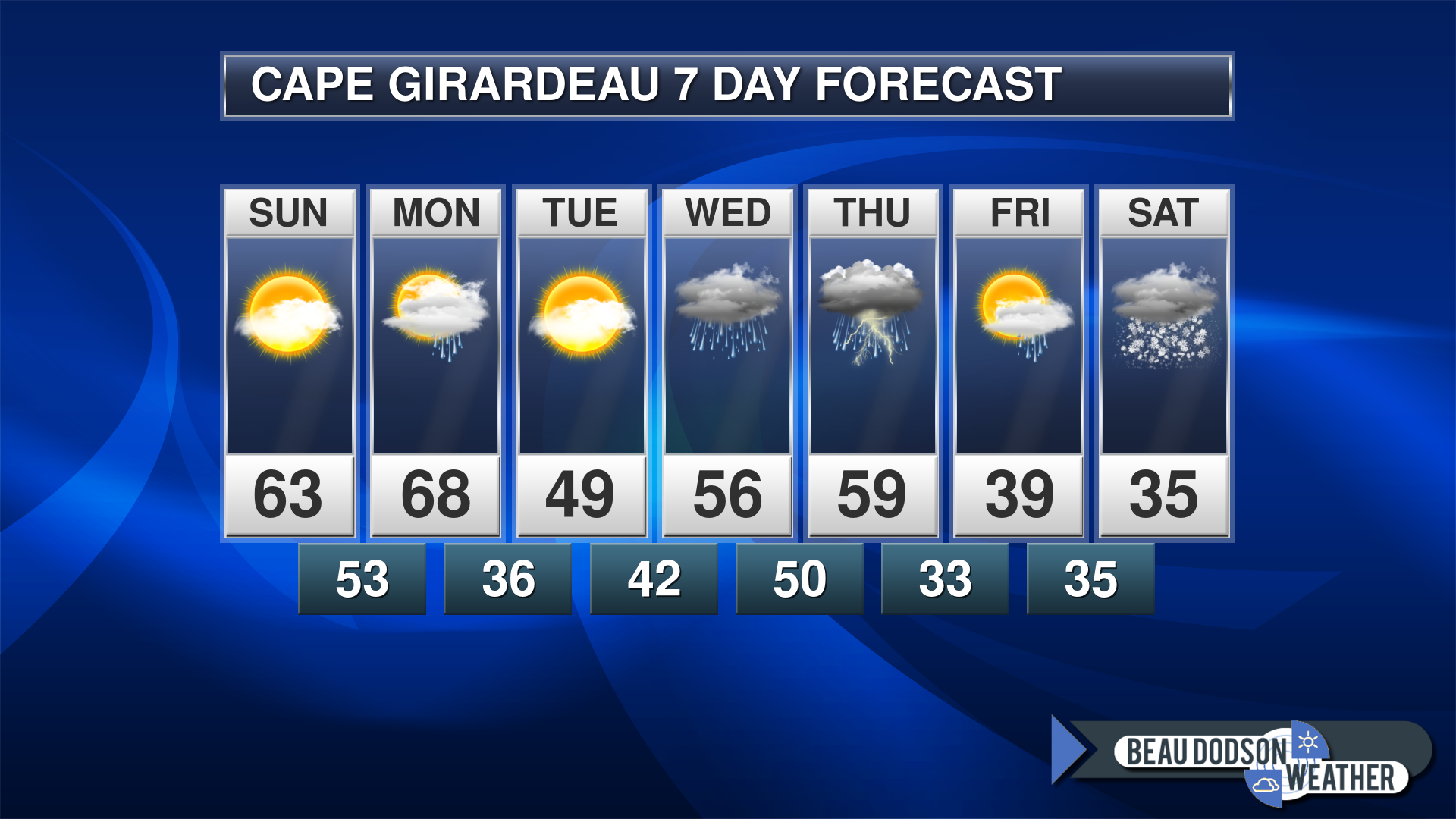
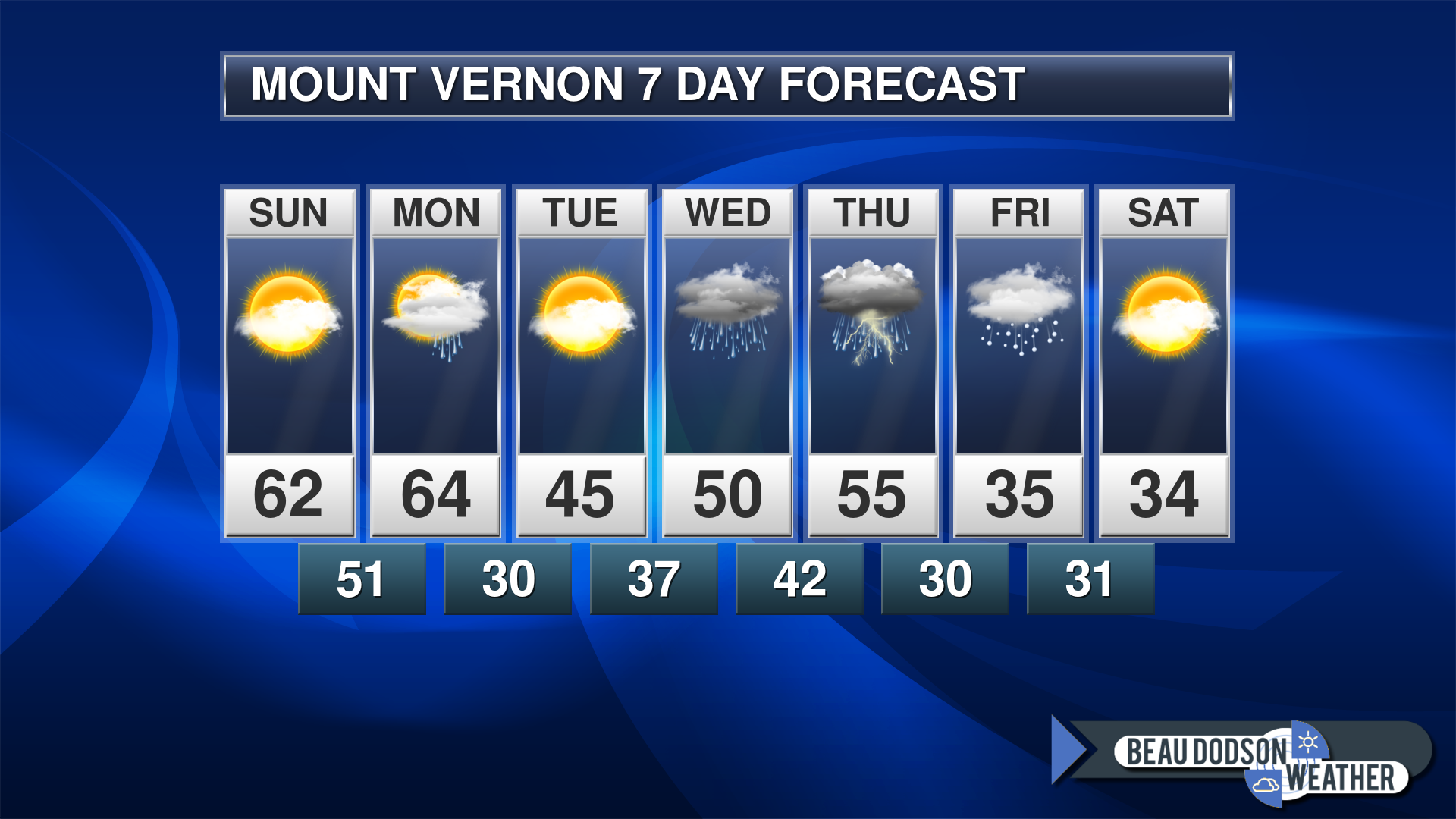
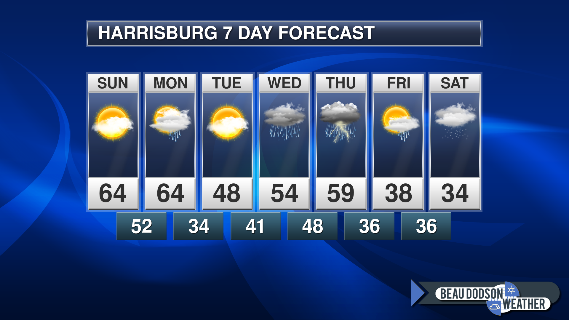
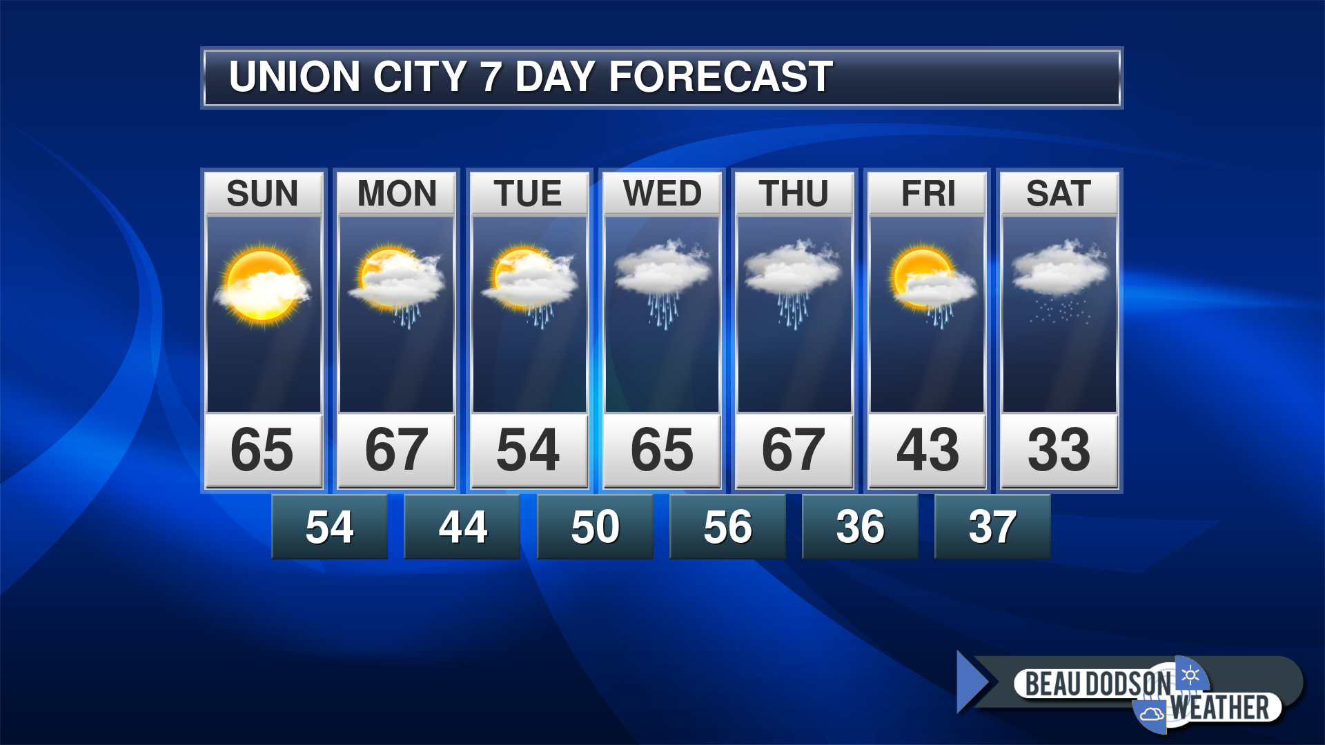
Some random locations in the region. Seven-day forecast.
I will put together a more detailed forecast tomorrow morning when the regular blog updates will be posted.
There are some questions about Thursday night into Friday. Perhaps the precipitation ends as a wintry mix. Too soon for certainties.
Any snow chances late in the week have a low confidence stamp on them.
Rain chances on Monday will be 30% to 40%
Rain chances on Wednesday and Thursday will be 60%
Rain chances on Friday will be 30%
Rain or mix chances on Saturday will be 20%


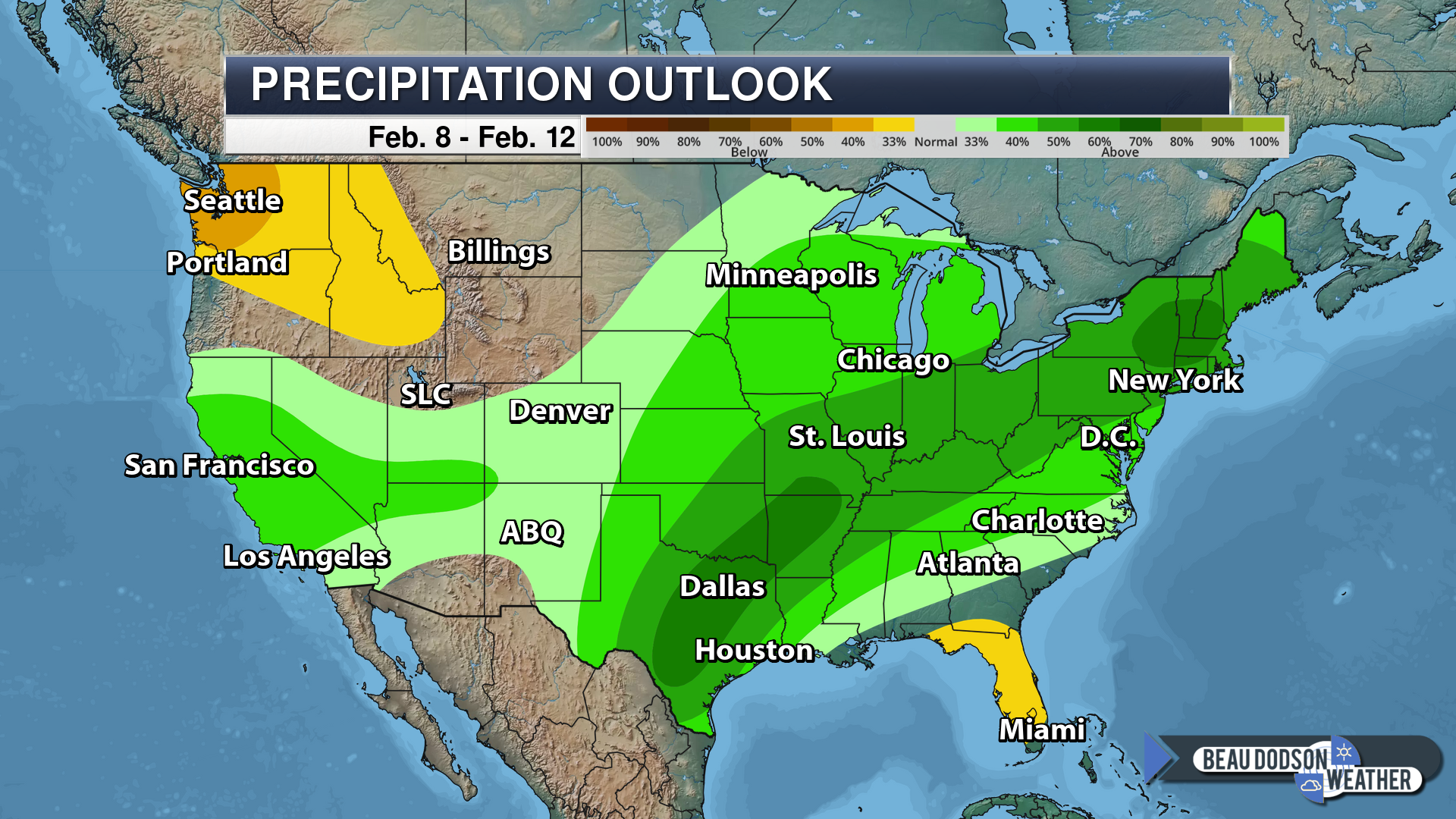
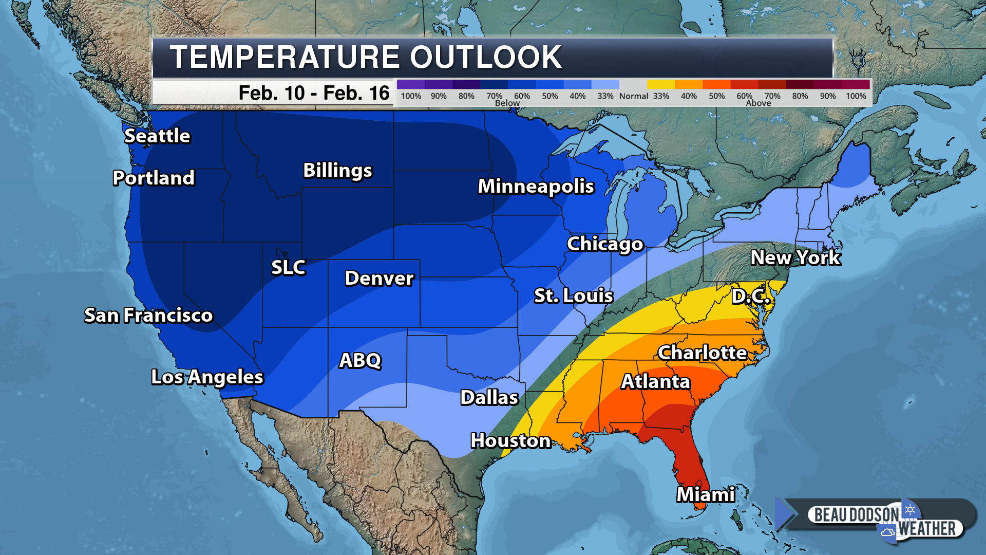
The 6 to 10 and 8 to 14-day temperature and precipitation outlooks.
6 to 10-day outlook

8-14 day outlook


Here is the latest graphic from the WPC/NOAA.
This map shows you liquid and does not assume precipitation type. In other words, melted precipitation totals.
A wet and stormy pattern is developing for February.
We promised an active and cold winter. The active part has verified. The cold has not lasted all that long.
River flooding concerns are going to rise if this pattern continues.

Interactive GOES R satellite. Track clouds. Click here.
![]()

A new weather podcast is now available! Weather Geeks (which you might remember is on The Weather Channel each Sunday)
To learn more visit their website. Click here.
![]()

WeatherBrains Episode 680
Tonight’s Guest WeatherBrain is the teaching professor in meteorology and the associate head of the undergraduate program in meteorology at The Penn State University. He is also the host, feature writer, and producer of Weather World, Penn State Meteorology Department’s weekday weather magazine show. He also produces a segment on Wednesday’s called WeatherWhys (WxYz). In addition, he was an on-air storm analyst at The Weather Channel from 2002 to 2005 (just after Dr. John Scala was there) and was the chief meteorologist at the historic Franklin Institute Science Museum in Philadelphia from 1998 to 2002. He has also co-authored two books: “The Philadelphia Area Weather Book” and “A World of Weather: Fundamentals of Meteorology.” Dr. Jon Nese, welcome to WeatherBrains!
Other discussions in this weekly podcast include topics like:
- Winter Storm in the South
- The Franklin Institute Weather Co-Op Observing Center
- Groundhog Day upcoming on Saturday
- NWS employees struggling during the government shutdown
- The Astronomy Report from Tony Rice
- and more.
.
.
Link to their website https://weatherbrains.com/
Previous episodes can be viewed by clicking here.

We offer interactive local city live radars and regional radars. If a radar does not update then try another one. If a radar does not appear to be refreshing then hit Ctrl F5. You may also try restarting your browser.
The local city view radars also have clickable warnings.
During the winter months, you can track snow and ice by clicking the winterize button on the local city view interactive radars.
You may email me at beaudodson@usawx.com
Find me on Facebook!

Find me on Twitter!

Did you know that a portion of your monthly subscription helps support local charity projects?
You can learn more about those projects by visiting the Shadow Angel Foundation website and the Beau Dodson News website.

I encourage subscribers to use the app vs regular text messaging. We have found text messaging to be delayed during severe weather. The app typically will receive the messages instantly. I recommend people have three to four methods of receiving their severe weather information.
Remember, my app and text alerts are hand typed and not computer generated. You are being given personal attention during significant weather events.
