This is what you are missing out on if you are not a $3 a month subscriber!
- Daily forecast texts from my computer to your app/cell phone
- Severe weather app/text alerts from my keyboard to your app/cell phone
- Social media links sent directly to your app/cell phone. When I update the blog, videos, or Facebook you will receive the link.
- Missouri Valley centered video updates
- Ohio Valley centered video updates
- Long-range video updates
- Week one temperature and precipitation outlook
- Week two temperature and precipitation outlook
- Week three and four temperature and precipitation outlook
- Monthly outlooks
Monthly operating costs for Weather Talk can top $2000.00. Your $3 subscription helps pay for those costs. I work for you.
.
.

.

.
Your $3 per month also helps support these local charity projects.
.

.

.
February 28, 2018
Wednesday Forecast Details
Forecast: Quite a few clouds. Mild temperatures. Scattered showers. An isolated thunderstorm possible. The highest chance of rain should be before 12 PM over our northern counties. At any given time from the Ohio River southward.
Temperatures: MO ~ 62 to 66 IL ~ 62 to 66 KY ~ 62 to 66
What is the chance of precipitation? MO ~ 60% IL ~ 60% KY ~ 60% TN ~ 70%
Coverage of precipitation: Becoming scattered as the day wears on. Greatest coverage in the afternoon will be from the Bootheel of Missouri and then into northwest Tennessee and western Kentucky.
Wind chill values: N/A
Accumulating snow or ice: No
Winds: South and southwest at 8 to 16 mph
What impacts are anticipated from the weather? Wet roadways
My confidence in the forecast verifying: High
Is severe weather expected? Not at this time
The NWS defines severe weather as 58 mph wind or great, 1″ hail or larger, and/or tornadoes
Should I cancel my outdoor plans? Have a plan B
.
Wednesday Night Forecast Details:
Forecast: Cloudy. Cool. Rain likely. A thunderstorm possible.
Temperatures: MO ~ 50 to 55 IL ~ 50 to 55 KY ~ 50 to 55
What is the chance of precipitation? MO ~ 70% IL ~ 70% KY ~ 80% TN ~ 80%
Coverage of precipitation: Widespread
Wind chill values: N/A
Accumulating snow or ice: No
Winds: South at 7 to 14 mph
What impacts are anticipated from the weather? Wet roadways. Perhaps lightning.
My confidence in the forecast verifying: High on the rain. Low on the thunderstorms.
Is severe weather expected? No
The NWS defines severe weather as 58 mph wind or great, 1″ hail or larger, and/or tornadoes
Should I cancel my outdoor plans? Have a plan B
.
March 1, 2018
Thursday Forecast Details
Forecast: Mostly cloudy early. Highs early in the day. Windy. Turning cooler. A chance of showers before noon. Showers ending.
Temperatures: MO ~ 54 to 58 IL ~ 54 to 58 KY ~ 56 to 58
What is the chance of precipitation? MO ~ 30% ending IL ~ 30% ending KY ~ 60% mainly early TN ~ 60% mainly early
Coverage of precipitation: Scattered early
Wind chill values: N/A
Accumulating snow or ice: No
Winds: Southwest to west & northwest at 15 to 30 mph with gusts to 44 mph
What impacts are anticipated from the weather? Wet roadways. Strong winds.
My confidence in the forecast verifying: Medium
Is severe weather expected? No
The NWS defines severe weather as 58 mph wind or great, 1″ hail or larger, and/or tornadoes
Should I cancel my outdoor plans? No, but monitor updates. Some morning showers possible. Strong winds.
.
Thursday Night Forecast Details:
Forecast: Clearing. Cool. Windy.
Temperatures: MO ~ 28 to 34 IL ~ 28 to 34 KY ~ 28 to 34
What is the chance of precipitation? MO ~ 0% IL ~ 0% KY ~ 0% TN ~ 0%
Coverage of precipitation: None
Wind chill values: N/A
Accumulating snow or ice: No
Winds: West and northwest at 10 to 20 mph with gusts to 25
What impacts are anticipated from the weather? None
My confidence in the forecast verifying: High
Is severe weather expected? No
The NWS defines severe weather as 58 mph wind or great, 1″ hail or larger, and/or tornadoes
Should I cancel my outdoor plans? No
.
March 2, 2018
Friday Forecast Details
Forecast: Mostly sunny. Nice.
Temperatures: MO ~ 50 to 55 IL ~ 50 to 55 KY ~ 50 to 55
What is the chance of precipitation? MO ~ 0% IL ~ 0% KY ~ 0% TN ~ 0%
Coverage of precipitation: None
Wind chill values: N/A
Accumulating snow or ice: No
Winds: Northwest and north at 7 to 14 mph
What impacts are anticipated from the weather? None
My confidence in the forecast verifying: High
Is severe weather expected? No
The NWS defines severe weather as 58 mph wind or great, 1″ hail or larger, and/or tornadoes
Should I cancel my outdoor plans? No
.
Friday Night Forecast Details:
Forecast: Mostly clear and cool.
Temperatures: MO ~ 29 to 34 IL ~ 28 to 34 KY ~ 30 to 35
What is the chance of precipitation? MO ~ 0% IL ~ 0% KY ~ 0% TN ~ 0%
Coverage of precipitation: None
Wind chill values: N/A
Accumulating snow or ice: No
Winds: North at 4 to 8 mph
What impacts are anticipated from the weather? None
My confidence in the forecast verifying: High
Is severe weather expected? No
The NWS defines severe weather as 58 mph wind or great, 1″ hail or larger, and/or tornadoes
Should I cancel my outdoor plans? No
.
March 3, 2018
Saturday Forecast Details
Forecast: Mostly sunny.
Temperatures: MO ~ 53 to 56 IL ~ 53 to 56 KY ~ 53 to 56
What is the chance of precipitation? MO ~ 0% IL ~ 0% KY ~ 0% TN ~ 0%
Coverage of precipitation: None
Wind chill values: N/A
Accumulating snow or ice: No
Winds: Variable at 5 mph
What impacts are anticipated from the weather? None
My confidence in the forecast verifying: High
Is severe weather expected? No
The NWS defines severe weather as 58 mph wind or great, 1″ hail or larger, and/or tornadoes
Should I cancel my outdoor plans? No
.
Saturday Night Forecast Details:
Forecast: Mostly clear.
Temperatures: MO ~ 30 to 35 IL ~ 30 to 35 KY ~ 30 to 35
What is the chance of precipitation? MO ~ 0% IL ~ 0% KY ~ 0% TN ~ 0%
Coverage of precipitation: None
Wind chill values: N/A
Accumulating snow or ice: No
Winds: Southeast and east at 5 mph
What impacts are anticipated from the weather? None
My confidence in the forecast verifying: High
Is severe weather expected? No
The NWS defines severe weather as 58 mph wind or great, 1″ hail or larger, and/or tornadoes
Should I cancel my outdoor plans? No
.
March 4, 2018
Sunday Forecast Details
Forecast: Mostly sunny. Mild. Some increase in clouds late in the day. A 10% of a shower near Poplar Bluff.
Temperatures: MO ~ 56 to 60 IL ~ 56 yo 60 KY ~ 56 to 62
What is the chance of precipitation? MO ~ 10% IL ~ 0% KY ~ 0% TN ~ 0%
Coverage of precipitation: Most likely none
Wind chill values: N/A
Accumulating snow or ice: No
Winds: East and southeast at 5 to 10 mph
What impacts are anticipated from the weather? None
My confidence in the forecast verifying: High
Is severe weather expected? No
The NWS defines severe weather as 58 mph wind or great, 1″ hail or larger, and/or tornadoes
Should I cancel my outdoor plans? No
.
Sunday Night Forecast Details:
Forecast: Increasing clouds. A chance of showers mainly after 2 AM. Rain chances may arrive earlier over southeast Missouri.
Temperatures: MO ~ 40 to 45 IL ~ 40 to 45 KY ~ 40 to 45
What is the chance of precipitation? MO ~ 60% IL ~ 40% KY ~ 40% TN ~ 40%
Coverage of precipitation: Scattered late
Wind chill values: N/A
Accumulating snow or ice: No
Winds: South at 6 to 12 mph
What impacts are anticipated from the weather? Wet roadways late
My confidence in the forecast verifying: Medium
Is severe weather expected? No
The NWS defines severe weather as 58 mph wind or great, 1″ hail or larger, and/or tornadoes
Should I cancel my outdoor plans? No
.
March 5, 2018
Monday Forecast Details
Forecast: Cloudy. Scattered showers.
Temperatures: MO ~ 54 to 58 IL ~ 54 to 58 KY ~ 54 to 58
What is the chance of precipitation? MO ~ 60% IL ~ 60% KY ~ 60% TN ~ 60%
Coverage of precipitation: Scattered
Wind chill values: N/A
Accumulating snow or ice: No
Winds: Southeast and south at 5 to 10 mph
What impacts are anticipated from the weather? Wet roadways.
My confidence in the forecast verifying: Medium
Is severe weather expected? No
The NWS defines severe weather as 58 mph wind or great, 1″ hail or larger, and/or tornadoes
Should I cancel my outdoor plans? Monitor
.
Monday Night Forecast Details:
Forecast: Cloudy. A chance of showers.
Temperatures: MO ~ 36 to 42 IL ~ 36 to 42 KY ~ 36 to 42
What is the chance of precipitation? MO ~ 40% IL ~ 40% KY ~ 50% TN ~ 50%
Coverage of precipitation: Scattered
Wind chill values: N/A
Accumulating snow or ice: No
Winds: West at 4 to 8 mph with gusts to 12 mph
What impacts are anticipated from the weather? Wet roadways.
My confidence in the forecast verifying: Medium
Is severe weather expected? No
The NWS defines severe weather as 58 mph wind or great, 1″ hail or larger, and/or tornadoes
Should I cancel my outdoor plans? Monitor
.

.
Today through Tuesday: Winter weather is not anticipated.
.

.
The National Weather Service definition of a severe thunderstorm is one that produces quarter size hail or larger, 58 mph winds or greater, and/or a tornado.
Today through Thursday: No severe weather. Lightning is possible today into Wednesday night.
.

.
HIGHLIGHTS
- On and off showers today. Coverage will lesson over southeast Missouri and southern Illinois. Numerous showers may remain throughout the day from the Missouri Bootheel into Kentucky and Tennessee.
- Widespread rain Wednesday night ending Thursday morning.
- Severe weather is not anticipated. Lightning is possible.
- Strong and gusty winds Thursday. Gusts above 35 mph possible.
- Flooding continues to be a problem.
- Dry Thursday night through Sunday afternoon.
- Rain chances return Sunday night into Monday.
High confidence today into Sunday afternoon.
Shorter update today, because I have a weather conference to attend.
Rain moved back into the region overnight. Thankfully, for most of the area, the rain is not causing too many additional problems. It is just aggravating the already bad situation in many areas. We don’t need more rain. That is no secret.
There could be some water issues over the Missouri Bootheel into south central Kentucky. If some heavier rain develops later today and tonight you could have some ditches flood onto roadways. Rivers remain high there, as well.
Need to check the latest river crest forecast? Click here.
Please check out the interactive city view radars to track the precipitation.
.

.
We offer regional radars and local city radars – if a radar does not update then try another one. Occasional browsers need their cache cleared. You may also try restarting your browser. This will usually fix any problems.
Flooding continues in many communities. Avoid flooded roadways. Sadly, at least one death has been reported because of the flooding.
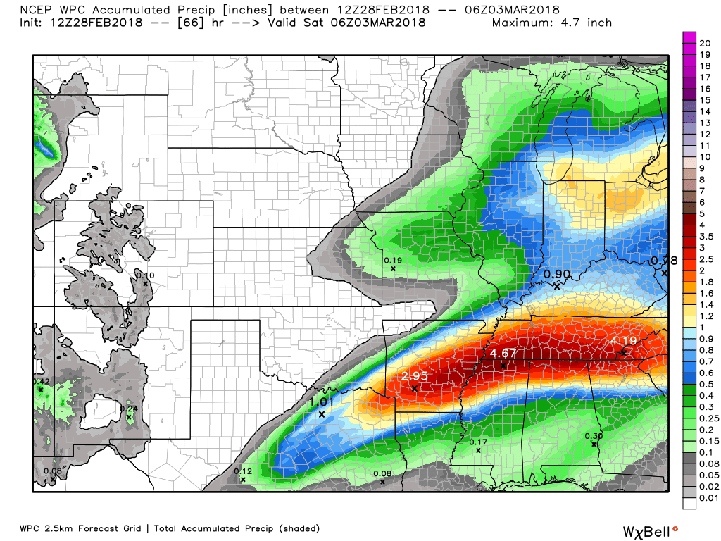
Here is the current NOAA rain forecast. This is what should fall Thursday morning.
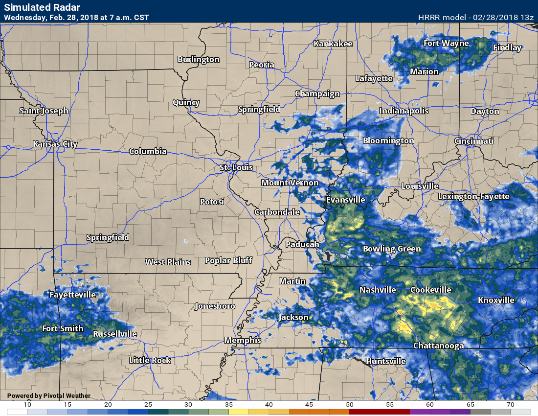
Heaviest rain totals will be from the Bootheel of Missouri and then along the Kentucky/Tennessee border.
.
.
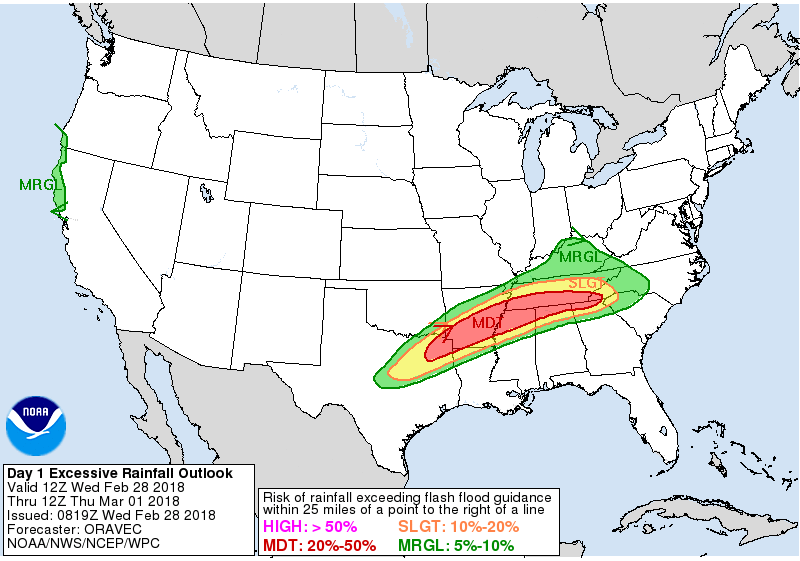
Portions of the region have been placed in a marginal to slight risk of flash flooding Wednesday and Wednesday night.
.
.
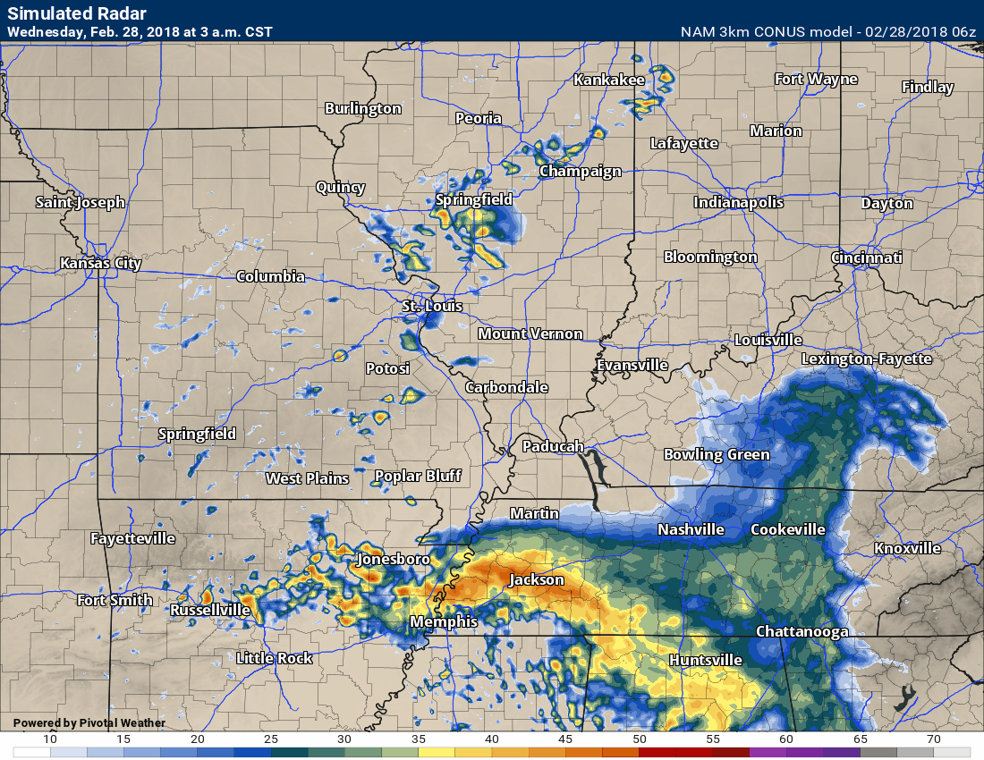
Here is the NAM model guidance future-cast radar.
Timestamp upper left portion of the graphic.
.
.
Here is the high-resolution Hrrr guidance. Time stamp upper left. This is for today into Thursday. You can see where the heavier rain is focused.
.
 .
.
.
Conditions dry out Thursday late morning into the afternoon. Lingering showers will end from west to east.
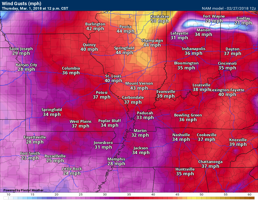
Winds pick up Thursday as a strong pressure gradient develops.
You can expect some wind gusts over 35 mph Thursday.
Here is the 12 PM wind gust forecast for Thursday. Winds will be gusty throughout the day.
.
.
Dry weather Friday through Sunday morning. I can’t rule out a few showers Sunday afternoon overs southeast Missouri. The rain will likely hold off until Sunday night into Monday.
Rainfall totals Sunday night into Monday should be fairly light. At this time, it appears totals will be less than 0.30″.
Need to check the latest river crest forecast? Click here.
We will need to monitor river stages. Rivers are going to rise over the coming weeks.
.

.
The daily outlook can be found at the bottom of this post.
.
.
We offer regional radars and local city radars – if a radar does not update then try another one. Occasional browsers need their cache cleared. You may also try restarting your browser. This will usually fix any problems.
Need to check the latest river crest forecast? Click here.
We will need to monitor river stages. Rivers are going to rise over the coming weeks.
.
.
The preliminary spring and summer forecast has been posted on the subscription website. Subscribe at www.beaudodsonweather.com
Spring and Summer outlook – Click here
.


We offer regional radars and local city radars – if a radar does not update then try another one. Occasional browsers need their cache cleared. You may also try restarting your browser. This will usually fix any problems.
During the winter you can track snow and ice by clicking the winterize button on the local city view interactive radars.
You may email me at beaudodson@usawx.com
Interactive Weather Radar Page. Choose the city nearest your location: Click this link
National interactive radar: Click this link.