
Are you in need of new eye glasses? New contacts? Perhaps you need an eye exam. Then be sure and visit the Eye Care Associates of western Kentucky (the Paducah location). For all of your families eye care needs.
Visit their web-site here. Or, you can also visit their Facebook page.

Best at Enabling Body Shop Profitability since 1996. Located In Paducah Kentucky and Evansville Indiana; serving all customers in between. They provide Customer Service, along with all the tools necessary for body shops to remain educated and competitive. Click the logo above for their main web-site.
You can find McClintock Preferred Finishes on Facebook, as well

Expressway Carwash and Express Lube are a locally owned and operated full-service Carwash and Lube established in 1987.
They have been proudly serving the community for 29 years now at their Park Avenue location and 20 years at their Southside location. They have been lucky enough to partner with Sidecar Deli in 2015, which allows them to provide their customers with not only quality service, but quality food as well.
If you haven’t already, be sure to make Expressway your one-stop shop, with their carwash, lube and deli. For hours of operation and pricing visit www.expresswashlube.com or Expressway Carwash on Facebook.

The quad states area source for Precision Ag Technology. Locally owned and operated, specializing in planting, harvesting, fertilizer application and drainage. Visit them on their website and on Facebook. You can also find them on Twitter. They are located in Almo, Kentucky. Phone 270-718-0245
.———————————————–
The Beau Dodson Weather APP is ready for Apple users (Android is next). The purpose of this APP is for me to deliver your text messages instantly. ATT and Verizon have not always been reliable when it comes to speed. The APP allows instant delivery. You can keep your test messages on and use the APP. You can set the APP to turn off your text messages and just receive them through the APP.
We are working on the Android APP. Hopefully, it will be available in a week or so.
The APP is for subscribers.

The direct download can be viewed here
https://itunes.apple.com/us/app/id1190136514
If you have not signed up for the texting service then you may do so at www.beaudodsonweather.com
If you have not signed up for the texts messages, then please do. Your support helps with all of this

and


This forecast update covers far southern Illinois, far southeast Missouri, and far western Kentucky. See the coverage map on the right side of the blog
.
February 26, 2017
Sunday Night Forecast Details:
Forecast: Cloudy. Rain likely.
What impacts are anticipated from the weather? Wet roadways.
Is severe weather expected? No
The NWS defines severe weather as 58 mph winds or great, 1″ hail or larger, and/or tornadoes
What is the chance of precipitation? MO ~ 70% IL ~ 70% KY ~ 70% TN ~ 70%
Coverage of precipitation: Becoming numerous.
Should I cancel my outdoor plans? Monitor radars and updated forecasts.
My confidence in the forecast verifying: Medium. Some adjustments are possible.
Temperatures: MO ~ 40 to 45 IL ~ 40 to 45 KY ~ 40 to 45 TN ~ 42 to 46
Winds: South and southeast at 5 to 10 mph
Wind Chill when applicable:
Will there be a chance for wintry precipitation? No
Moonrise will be at 6:32 a.m. and moonset will be at 6:03 p.m. New Moon
.
February 27, 2017
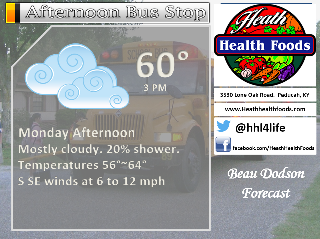
Monday Forecast Details
Forecast: Cloudy with a chance for showers before 12 pm. Cloudy during the afternoon hours. Only a slight chance for an afternoon shower. Milder.
What impacts are anticipated from the weather? Wet roadways
Is severe weather expected? No
The NWS defines severe weather as 58 mph winds or great, 1″ hail or larger, and/or tornadoes
What is the chance of precipitation? MO ~ 40% IL ~ 40% KY ~ 60% TN ~ 60%
Coverage of precipitation: Numerous early in the day and then isolated to none during the afternoon hours.
Should I cancel my outdoor plans? Have an alternative plan in the morning. Rain should exit from west to east early in the day.
My confidence in the forecast verifying: Medium. Some adjustments are possible.
Temperatures: MO ~ 56 to 62 IL ~ 56 to 62 KY ~ 56 to 62 TN ~ 56 to 64
Winds: South winds at 6 to 12 mph
Wind Chill when applicable:
Will there be a chance for wintry precipitation? No
Sunrise will be at 6:26 a.m. and sunset will be at 5:47 p.m.
UV Index: 0 to 2
Moonrise will be at 7:09 a.m. and moonset will be at 7:09 p.m. Waxing Crescent
Monday Night Forecast Details:
Forecast: Cloudy. A good chance for showers and some thunderstorms. Not as cold.
What impacts are anticipated from the weather? Wet roadways. Perhaps lightning.
Is severe weather expected? Unlikely
The NWS defines severe weather as 58 mph winds or great, 1″ hail or larger, and/or tornadoes
What is the chance of precipitation? MO ~ 60% IL ~ 60% KY ~ 60% TN ~ 60%
Coverage of precipitation: Scattered to perhaps numerous
Should I cancel my outdoor plans? Have an alternative plan in mind. Confidence is low as to if rain chances will linger into Monday night.
My confidence in the forecast verifying: Low. Significant adjustments are possible.
Temperatures: MO ~ 50 to 55 IL ~ 50 to 55 KY ~ 50 to 55 TN ~ 50 to 55
Winds: South winds at 6 to 12 mph
Wind Chill when applicable:
Will there be a chance for wintry precipitation? No
Moonrise will be at 7:09 a.m. and moonset will be at 7:09 p.m. Waxing Crescent
.
February 28, 2017
Tuesday Forecast Details
Forecast: Cloudy. Mild. Breezy. Thunderstorms with hail possible on Tuesday morning. Then, scattered showers and thunderstorms possible. Monitor updated forecasts. I can’t rule out strong storms.
What impacts are anticipated from the weather? Wet roadways and lightning. Monitor severe weather concerns.
Is severe weather expected? Possible
The NWS defines severe weather as 58 mph winds or great, 1″ hail or larger, and/or tornadoes
What is the chance of precipitation? MO ~ 50% IL ~ 50% KY ~ 50% TN ~ 50%
Coverage of precipitation: Scattered
Should I cancel my outdoor plans? Have an alternative plan in case it rains. It is possible the rain during the day on Tuesday won’t be all that widespread.
My confidence in the forecast verifying: Medium. Some adjustments are possible.
Temperatures: MO ~ 68 to 74 IL ~ 68 to 74 KY ~ 68 to 74 TN ~ 68 to 74
Winds: South winds at 6 to 12 mph with gusts to 25 mph
Wind Chill when applicable:
Will there be a chance for wintry precipitation? No
Sunrise will be at 6:25 a.m. and sunset will be at 5:47 p.m.
UV Index: 0 to 2
Moonrise will be at 7:46 a.m. and moonset will be at 8:15 p.m. Waxing Crescent
Tuesday Night Forecast Details:
Forecast: Cloudy. Severe thunderstorms possible. Monitor updates. Mild. Breezy.
What impacts are anticipated from the weather? Wet roadways and lightning. Severe weather possible. All modes.
Is severe weather expected? Yes. Monitor updates. All modes of severe weather possible.
The NWS defines severe weather as 58 mph winds or great, 1″ hail or larger, and/or tornadoes
What is the chance of precipitation? MO ~ 80% IL ~ 80% KY ~ 80% TN ~ 80%
Coverage of precipitation: Scattered to numerous
Should I cancel my outdoor plans? Have an alternative plan in mind.
My confidence in the forecast verifying: Medium. Some adjustments possible.
Temperatures: MO ~ 62 to 66 IL ~62 to 66 KY ~ 62 to 66 TN ~ 62 to 66
Winds: South and southwest winds at 10 to 20 mph with gusts to 35 mph. Higher in storms.
Wind Chill when applicable:
Will there be a chance for wintry precipitation? No
Moonrise will be at 7:46 a.m. and moonset will be at 8:15 p.m. Waxing Crescent
.
March 1, 2017
Wednesday Forecast Details
Forecast: Cloudy. Showers and storms possible early in the day and then a chance for scattered showers in the afternoon. Mild during the morning, but colder in the afternoon. Breezy, at times.
What impacts are anticipated from the weather? Wet roadways. Lightning.
Is severe weather expected? Tuesday night into Wednesday morning it is possible that we have severe weather.
The NWS defines severe weather as 58 mph winds or great, 1″ hail or larger, and/or tornadoes
What is the chance of precipitation? MO ~ 60% IL ~ 60% KY ~ 60% TN ~ 60% (decreasing chances area-wide after 12 pm)
Coverage of precipitation: Scattered to numerous early in the day and then isolated during the afternoon
Should I cancel my outdoor plans? Have a plan B in mind
My confidence in the forecast verifying: Medium. Some adjustments are possible.
Temperatures: MO ~ 65 to 70 IL ~ 65 to 70 KY ~ 65 to 70 TN ~ 65 to 70
Winds: Southwest becoming west/northwest at 10 to 20 mph
Wind Chill when applicable:
Will there be a chance for wintry precipitation? No
Sunrise will be at 6:23 a.m. and sunset will be at 5:49 p.m.
UV Index: 0 to 2
Moonrise will be at 8:23 a.m. and moonset will be at 9:22 p.m. Waxing Crescent
Wednesday Night Forecast Details:
Forecast: Decreasing clouds and colder.
What impacts are anticipated from the weather? None
Is severe weather expected? No
The NWS defines severe weather as 58 mph winds or great, 1″ hail or larger, and/or tornadoes
What is the chance of precipitation? MO ~ 0% IL ~ 0% KY ~ 0% TN ~ 0%
Coverage of precipitation: None
Should I cancel my outdoor plans? No
My confidence in the forecast verifying: Medium. Some adjustments are possible.
Temperatures: MO ~ 30 to 35 IL ~ 30 to 35 KY ~ 30 to 35 TN ~ 30 to 35
Winds: North and northwest at 6 to 12 mph
Wind Chill when applicable:28 to 32
Will there be a chance for wintry precipitation? No
Moonrise will be at 8:23 a.m. and moonset will be at 9:22 p.m. Waxing Crescent
.
March 2, 2017
Thursday Forecast Details
Forecast: Mostly sunny. Cooler.
What impacts are anticipated from the weather? None
Is severe weather expected? N0
The NWS defines severe weather as 58 mph winds or great, 1″ hail or larger, and/or tornadoes
What is the chance of precipitation? MO ~ 0% IL ~ 0% KY ~ 0% TN ~ 0%
Coverage of precipitation: None
Should I cancel my outdoor plans? No
My confidence in the forecast verifying: Medium. Some adjustments are possible.
Temperatures: MO ~ 50 to 55 IL ~ 50 to 55 KY ~ 50 to 55 TN ~ 50 to 55
Winds:
Wind Chill when applicable:
Will there be a chance for wintry precipitation? No
Sunrise will be at 6:22 a.m. and sunset will be at 5:50 p.m.
UV Index: 3 to 5
Moonrise will be at 9:01 a.m. and moonset will be at 10:28 p.m. Waxing Crescent
Thursday Night Forecast Details:
Forecast: Mostly clear. Cool.
What impacts are anticipated from the weather? None
Is severe weather expected? No
The NWS defines severe weather as 58 mph winds or great, 1″ hail or larger, and/or tornadoes
What is the chance of precipitation? MO ~ 0% IL ~ 0% KY ~ 0% TN ~ 0%
Coverage of precipitation: None
Should I cancel my outdoor plans? No
My confidence in the forecast verifying: Medium. Some adjustments are possible.
Temperatures: MO ~ 30 to 35 IL ~ 30 to 35 KY ~ 30 to 35 TN 30 ~ 35
Winds:
Wind Chill when applicable:
Will there be a chance for wintry precipitation? No
Moonrise will be at 9:01 a.m. and moonset will be at 10:28 p.m. Waxing Crescent
.
March 3, 2017
Friday Forecast Details
Forecast: Mostly sunny. Now as cool. Milder.
What impacts are anticipated from the weather? None
Is severe weather expected? No
The NWS defines severe weather as 58 mph winds or great, 1″ hail or larger, and/or tornadoes
What is the chance of precipitation? MO ~ 0% IL ~ 0% KY ~ 0% TN ~ 0%
Coverage of precipitation: None
Should I cancel my outdoor plans? No
My confidence in the forecast verifying: Medium. Some adjustments are possible.
Temperatures: MO ~ 55 to 60 IL ~ 55 to 60 KY ~ 55 to 60 TN ~ 55 to 60
Winds:
Wind Chill when applicable:
Will there be a chance for wintry precipitation? No
Sunrise will be at 6:20 a.m. and sunset will be at 5:51 p.m.
UV Index: 3 to 5
Moonrise will be at 9:42 a.m. and moonset will be at 11:35 p.m. Waxing Crescent
Friday Night Forecast Details:
Forecast: Mostly clear.
What impacts are anticipated from the weather? None
Is severe weather expected? No
The NWS defines severe weather as 58 mph winds or great, 1″ hail or larger, and/or tornadoes
What is the chance of precipitation? MO ~ 0% IL ~ 0% KY ~ 0% TN ~ 0%
Coverage of precipitation: None
Should I cancel my outdoor plans? No
My confidence in the forecast verifying:
Temperatures: MO ~ 35 to 40 IL ~ 35 to 40 KY ~ 36 to 42 TN ~ 36 to 42
Winds:
Wind Chill when applicable:
Will there be a chance for wintry precipitation? No
Moonrise will be at 9:42 a.m. and moonset will be at 11:35 p.m. Waxing Crescent
More information on the UV index. Click here
The School Bus Stop Forecast is sponsored by Heath Health and Wellness.
Located next to Crowell Pools in Lone Oak, Kentucky.
Visit their website here. Visit Heath Health Foods on Facebook!


Heath Health Foods is a locally owned and operated retail health and wellness store. Since opening in February 2006; the store has continued to grow as a ministry with an expanding inventory which also offers wellness appointments and services along with educational opportunities.
Visit their web-site here. And. visit Heath Health Foods on Facebook!.

Don’t forget to check out the Southern Illinois Weather Observatory web-site for weather maps, tower cams, scanner feeds, radars, and much more! Click here

An explanation of what is happening in the atmosphere over the coming day
Analysis
Sunday night
Confidence: High
Clouds will thicken and lower on Sunday night. Rain will develop. Widespread rain anticipated. No severe storms. It will be cool, but well above freezing.
Interactive Weather Radar Page. Choose the city nearest your location: Click this link—
Monday and Monday night
Confidence: High
Morning showers will move off to the east. We should have a dry late morning into the afternoon. Perhaps a small chance for an afternoon shower. Rain chances will increase on Monday night as another system pushes into the area. A rumble of thunder is also possible Monday night. Severe weather is not anticipated. A few moderate downpours possible.
Tuesday into Wednesday
Confidence: Medium
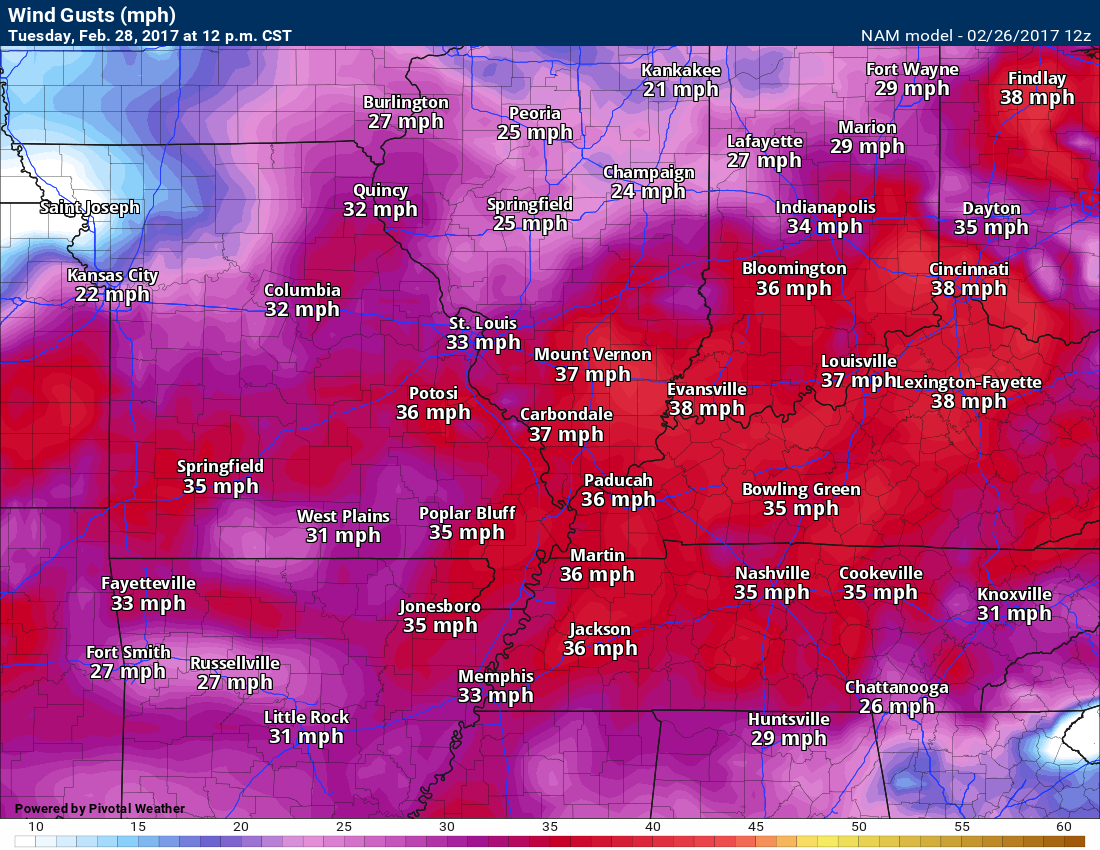
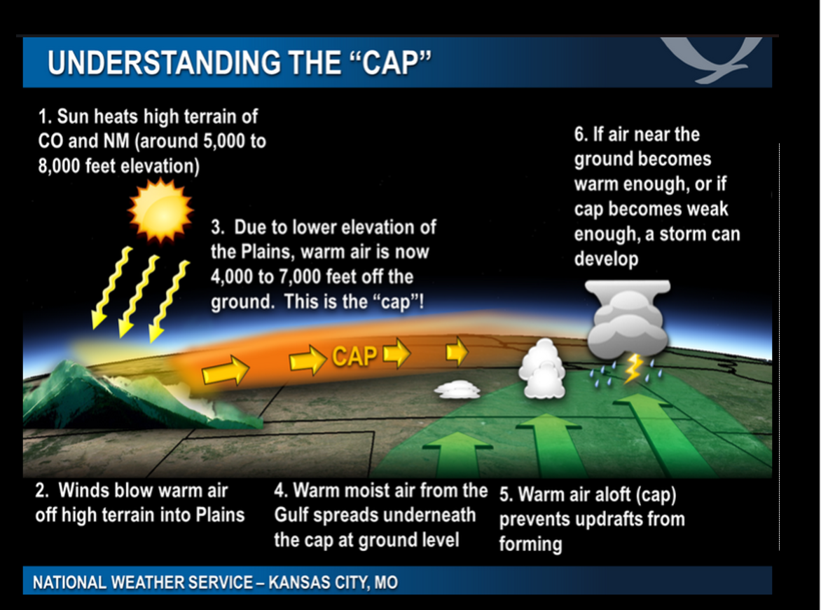
I am a bit concerned about what the charts are showing for Tuesday and Tuesday night. The atmosphere is expected to become unstable on Tuesday. There will be a cap on the atmosphere. A cap keeps thunderstorms from forming. Temperatures will warm into the 70’s. Dew points will climb into the 60’s. Strong southerly winds will gust above 30 mph.
Here is the wind forecast for 12 pm on Tuesday and 12 am on Wednesday. Gusty winds.
12 PM Tuesday
and 12 am Wednesday

An area of low pressure will push into the region on Tuesday night. This will help cause lift in the atmosphere. Thunderstorms are expected to develop Tuesday afternoon or more likely Tuesday night.
Storms that form on Tuesday and Tuesday night could be strong. I can’t rule out severe weather. I will know more on Monday afternoon and night.
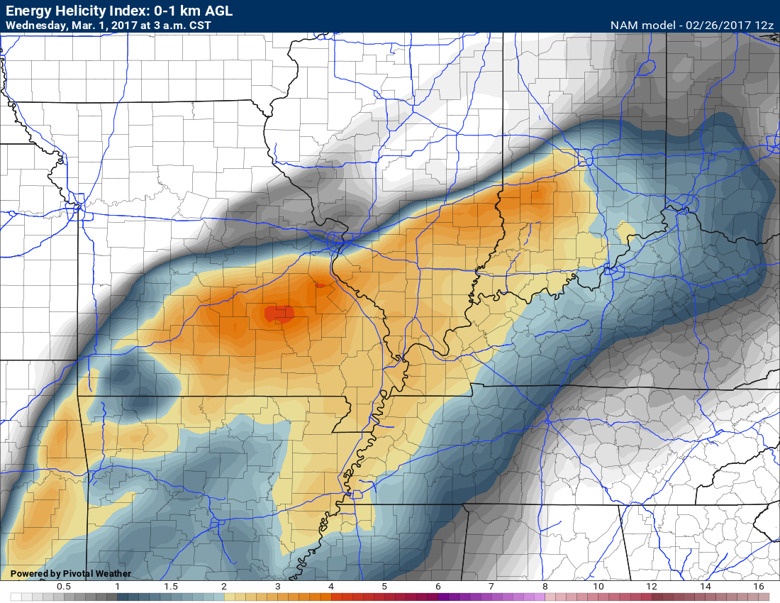
EHI numbers are high on the NAM guidance. EHI has to do with spinning in the atmosphere. CAPE and lifted index numbers are also high. Lapse rates are high. All of this signals the potential for severe thunderstorms. With that said, things could change. Monitor updates.
Let’s look at some of those parameters
Low ceiling heights. Low ceiling heights are one ingredient for severe weather.
The NAM shows low ceiling heights.

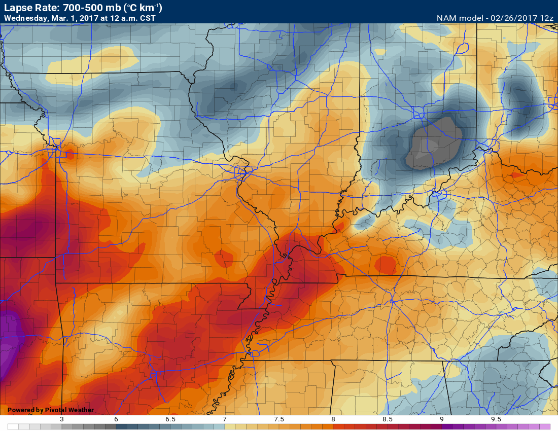
Next are the lapse rates. How fast does the atmosphere cool as you leave the surface and move upward. The steeper the lapse rate the greater the risk for hail.
These are steep lapse rates on the NAM. Large hail would be possible if this verifies.
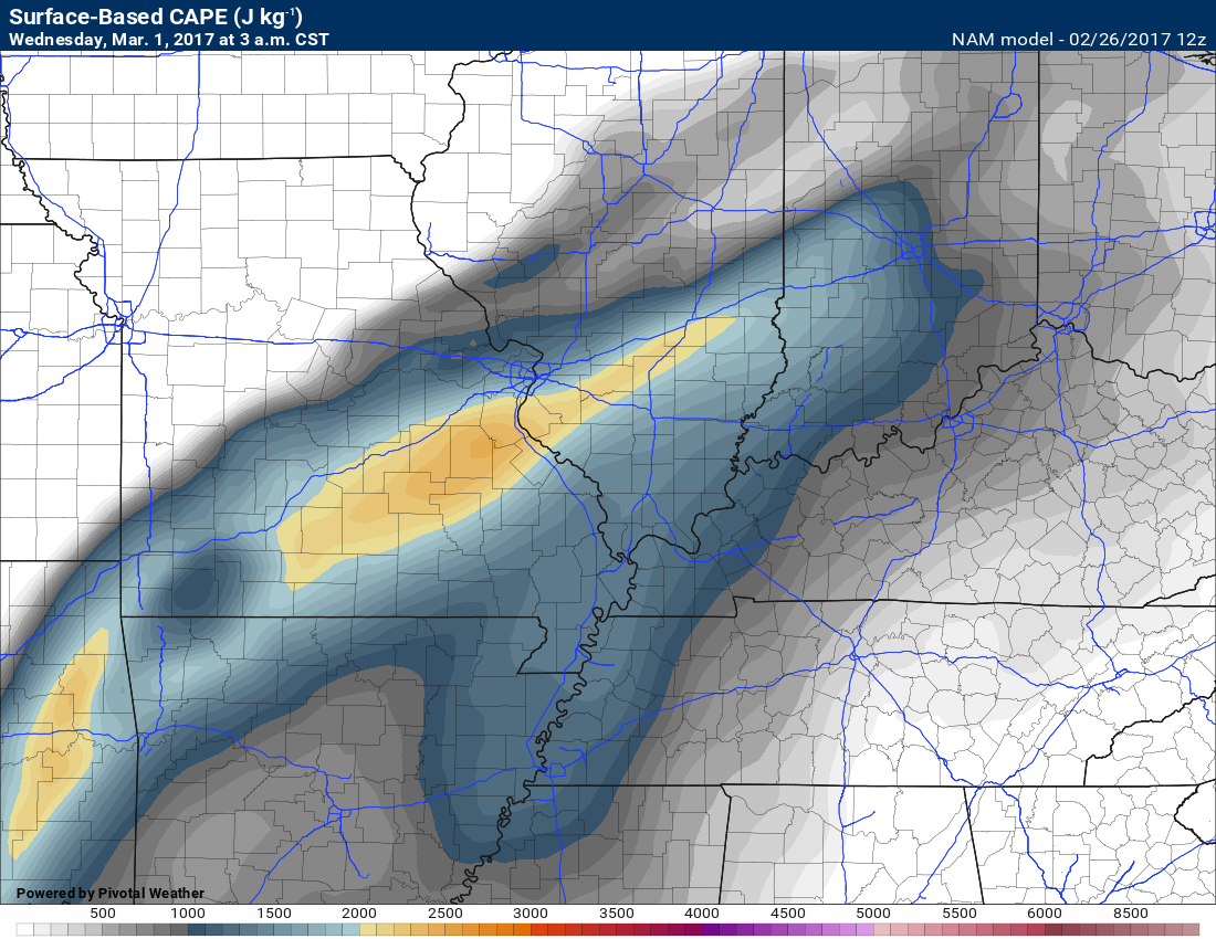
Next is the CAPE value map. These are high numbers for February. CAPE is energy that storms can tap into.
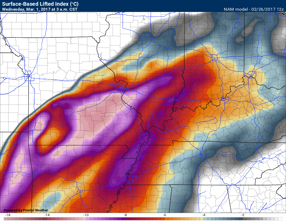
All of these charts are for Tuesday night.
Next is the lifted index map. The lower the number the more unstable the atmosphere. These are big numbers and indicate a very unstable atmosphere.
This next map is significant tornado parameter. It indicates that the atmosphere will be sheared. That means the atmosphere is turning. This is a signal of a tornado risk.
Again, this is the NAM model. One model of many.
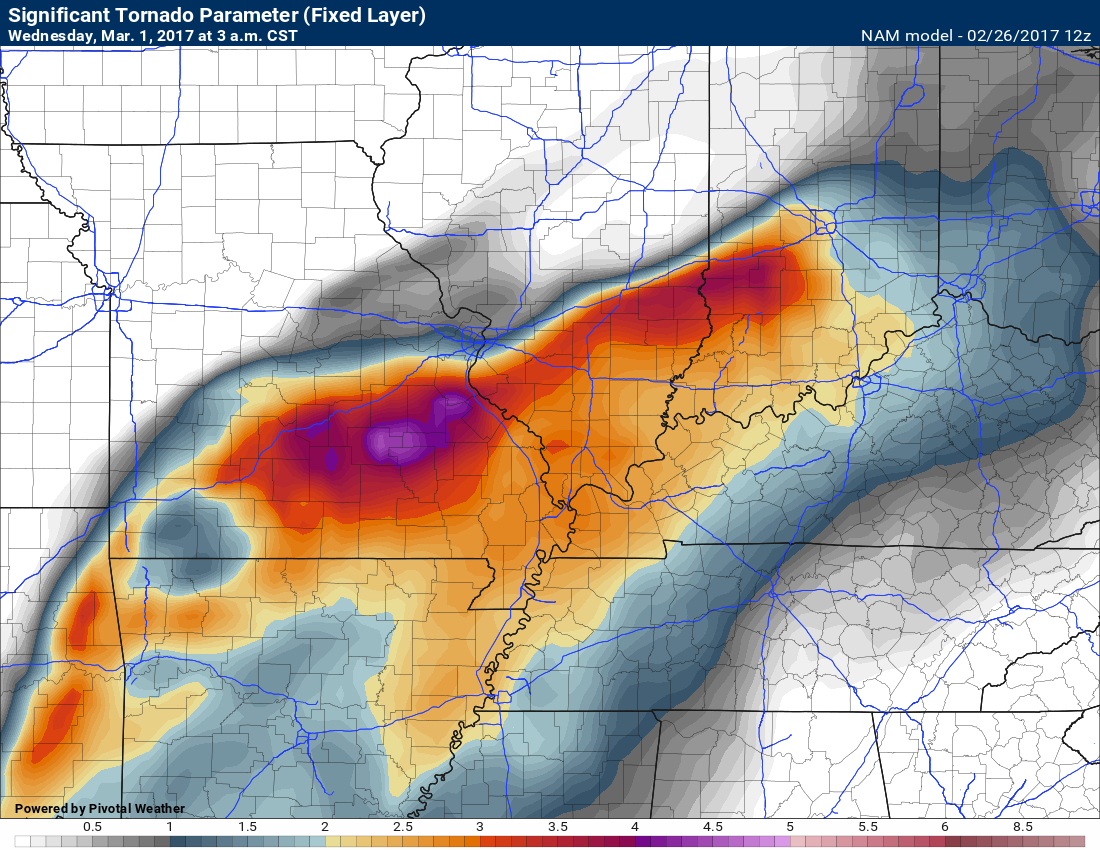
This next map is the EHI. Another indicator of tornado activity. These are high numbers, as well.
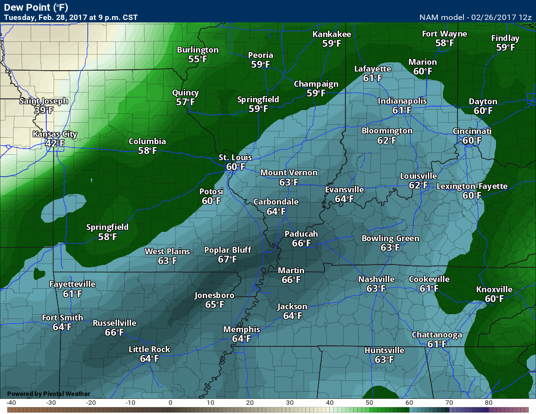
Dew points are very high for February. Another signal for severe storms.
Here is the CAP on Tuesday afternoon. Strong CAP. Tight lid on the atmosphere. If the CAP breaks then severe weather risks would increase.
The CAP is the red area to the right of the yellow line. That is a warm layer of air aloft. That helps keep storms from developing.
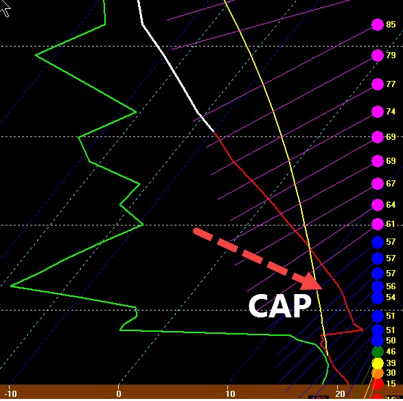
Here is an explanation of a CAP
I would encourage everyone to monitor the latest updates concerning this next weather event. Be sure and sign up for the text messages. Make sure you have the Weather One text option on. That is the severe weather text message.
Here is a video that describes each text message
Make sure you download the Apple App, as well. The Android version should be ready soon. Here is the link to the Apple version of the app. https://itunes.apple.com/us/app/id1190136514
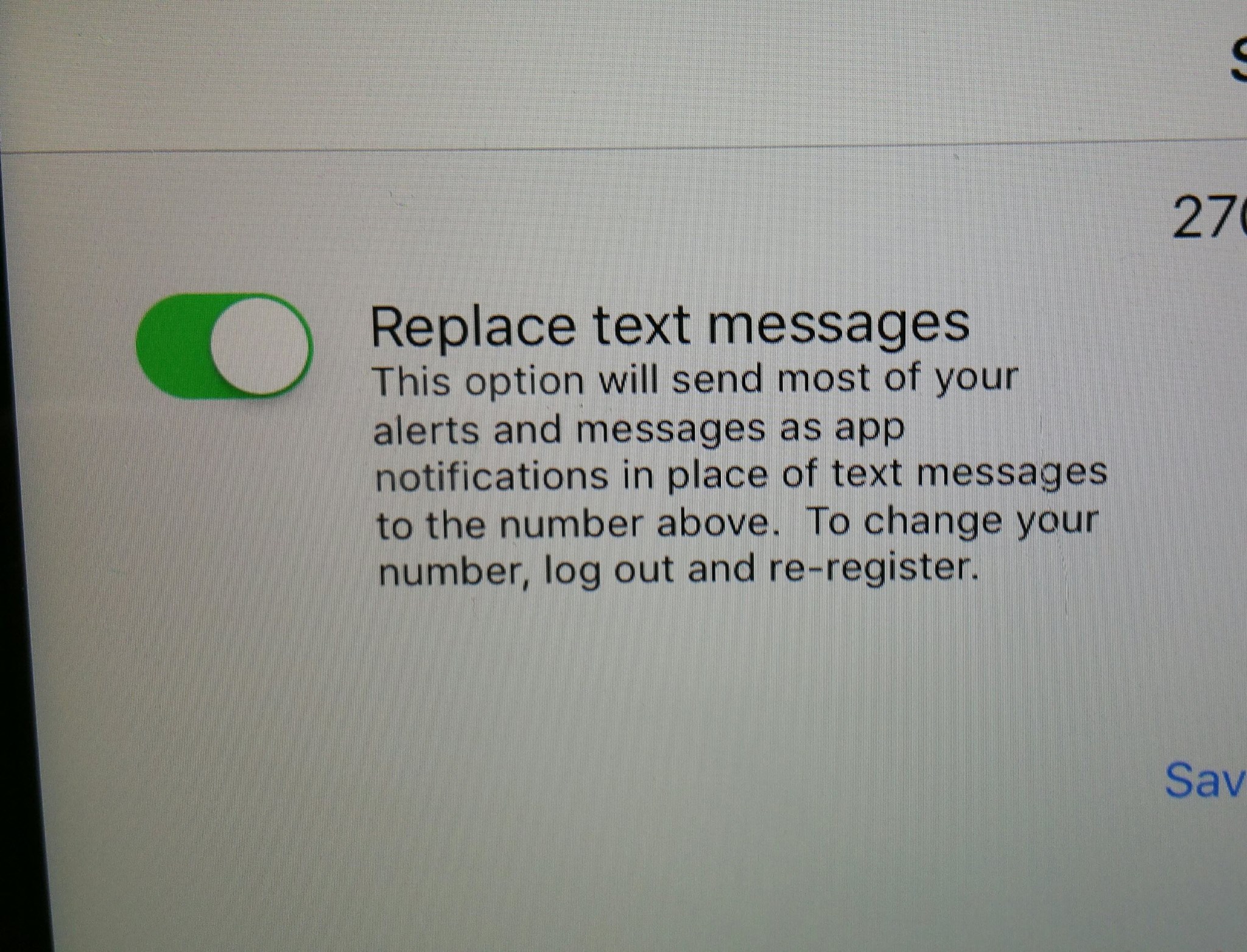
If you want to receive the text messages on both your phone and on the app (the app will always receive the messages faster) then make sure you do the following
Open your Weather Talk app
Click the settings button within the app
Turn OFF the green button.
If you want texts on your phone and the app then your setting should look like this

If you want the texts ONLY on your app then your setting should look like the image below

Severe thunderstorm outlook.
Remember that a severe thunderstorm is defined as a thunderstorm that produces 58 mph winds or higher, quarter size hail or larger, and/or a tornado.
I am closely monitoring Tuesday and Wednesday. Strong storms are possible. Severe weather possible. Closely monitor updated forecasts.
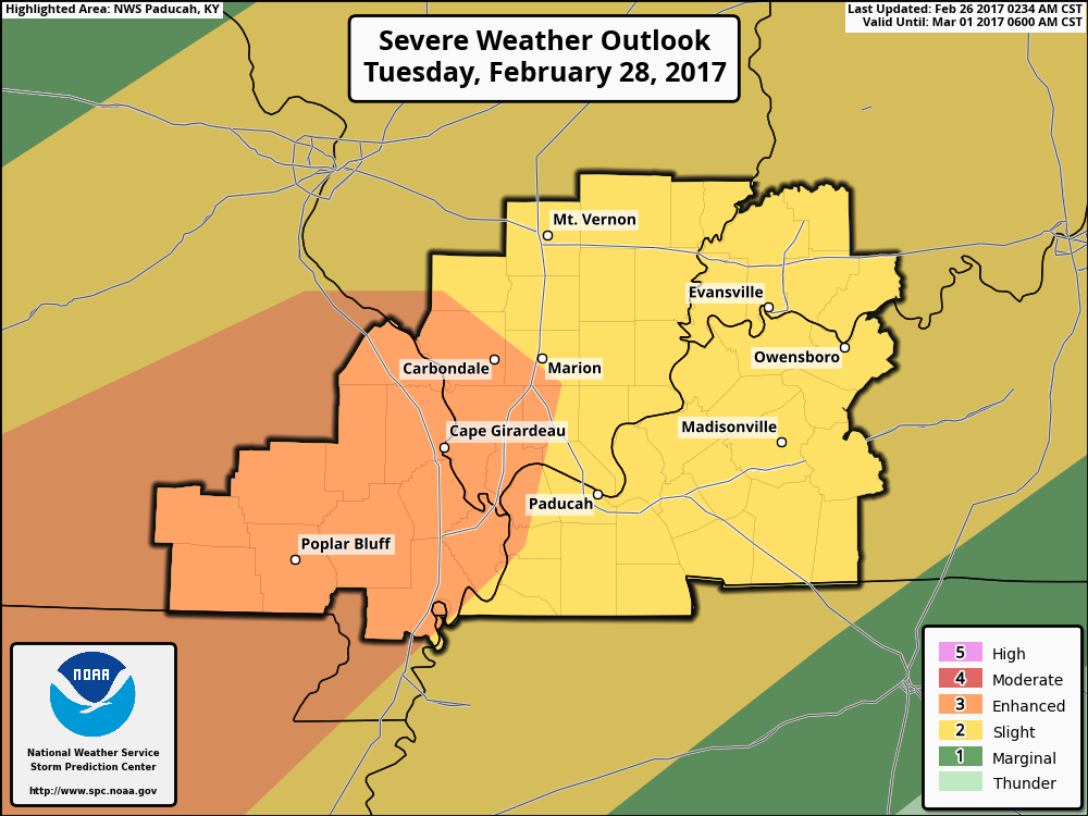
The Storm Prediction Center has outlined our region for severe storms on Tuesday and perhaps a higher risk on Tuesday night.
The yellow and orange zone is the greatest risk zone. This map will change several times between now and Tuesday.
Monitor updates.
.
Find me on Twitter

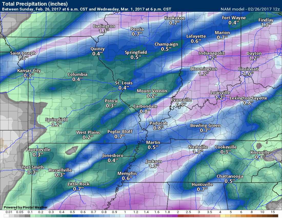
How much rain is expected over the coming days?
Here is the official NOAA rainfall predictions
Rainfall totals will be HIGHLY dependent on where individual thunderstorms track. I doubt these maps will be exact.
Thunderstorms can drop an inch or more of rain in short periods of time. Keep that in mind.
Here is what the NAM and GFS model guidance is painting for rain totals.

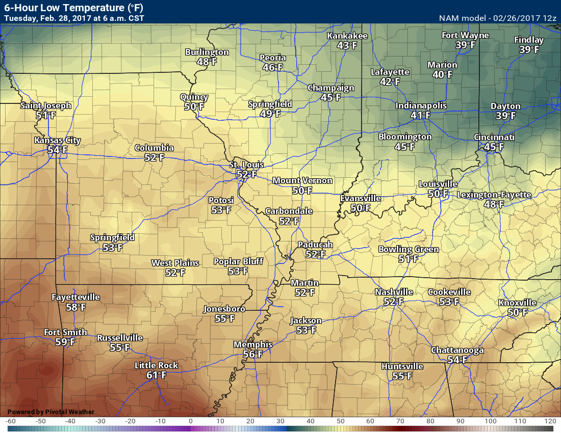
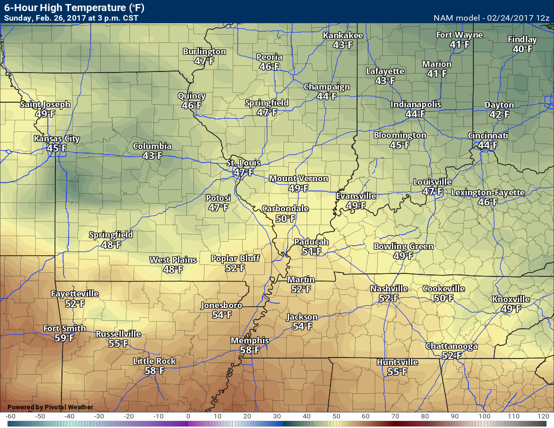
High and Low-Temperature Outlook
Monday low temperature forecast

Monday afternoon high temperature forecast

Tuesday low temperature forecast
Tuesday high temperature forecast


The main concern will be thunderstorms on Tuesday and Wednesday. Some of the storms could be intense. Be alert for updated information and changing weather.
.

We have regional radars and local city radars – if a radar does not update then try another one. Occasional browsers need their cache cleared. You may also try restarting your browser. That usually fixes the problem. Occasionally we do have a radar go down. That is why I have duplicates. Thus, if one fails then try another one.
During the winter you can track snow and ice by clicking the winterize button on the local city view interactive radars.
If you have any problems then please send me an email beaudodson@usawx.com
Interactive Weather Radar Page. Choose the city nearest your location: Click this link—
National interactive radar: Click this link.
Local interactive city radars include St Louis, Mt Vernon, Evansville, Poplar Bluff, Cape Girardeau, Marion, Paducah, Hopkinsville, Memphis, Nashville, Dyersburg, and all of eastern Kentucky. These are interactive radars. Local city radars – click here
Regional Radar


Here are the current river stage forecasts. You can click your state and then the dot for your location. It will bring up the full forecast and hydrograph.
..

The official 6-10 day and 8-14 day temperature and precipitation outlook. Check the date stamp at the top of each image (so you understand the time frame).
The forecast maps below are issued by the Weather Prediction Center (NOAA)


The latest 8-14 day temperature and precipitation outlook. Note the dates are at the top of the image. These maps DO NOT tell you how high or low temperatures or precipitation will be. They simply give you the probability as to whether temperatures or precipitation will be above or below normal.


Who do you trust for your weather information and who holds them accountable?
I have studied weather in our region since the late 1970’s. I have 39 years of experience in observing our regions weather patterns. My degree is in Broadcast Meteorology and a Bachelor’s of Science.
My resume includes:
Member of the American Meteorological Society.
NOAA Weather-Ready Nation Ambassador.
Meteorologist for McCracken County Emergency Management. I served from 2005 through 2015.
Meteorologist for McCracken County Rescue. 2015 through current
I own and operate the Southern Illinois Weather Observatory.
I am the chief meteorologist for Weather Talk LLC. I am the owner of Weather Talk LLC.
I am also a business owner in western Kentucky.
Recipient of the Mark Trail Award, WPSD Six Who Make A Difference Award, Kentucky Colonel, and the Caesar J. Fiamma” Award from the American Red Cross.
In 2005 I helped open the largest American Cross shelter in U.S. history in Houston, Texas. I was deployed to help after Hurricane Katrina and Hurricane Rita. I was a shelter manager of one of the Houston, Texas shelter divisions.
In 2009 I was presented with the Kentucky Office of Highway Safety Award.
Recognized by the Kentucky House of Representatives for my service to the State of Kentucky leading up to several winter storms and severe weather outbreaks.
If you click on the image below you can read the Kentucky House of Representatives Resolution.

I am also President of the Shadow Angel Foundation which serves portions of western Kentucky and southern Illinois.
There is a lot of noise on the internet. A lot of weather maps are posted without explanation. Over time you should learn who to trust for your weather information.
My forecast philosophy is simple and straight forward.
- Communicate in simple terms
- To be as accurate as possible within a reasonable time frame before an event
- Interact with you on Twitter, Facebook, email, texts, and this blog
- Minimize the “hype” that you might see on some television stations or through other weather sources
- Push you towards utilizing wall-to-wall LOCAL TV coverage during severe weather events
Many of the graphics on this page are from www.weatherbell.com
WeatherBell is a great resource for weather model guidance.


You can sign up for my AWARE email by clicking here I typically send out AWARE emails before severe weather, winter storms, or other active weather situations. I do not email watches or warnings. The emails are a basic “heads up” concerning incoming weather conditions