Afternoon update
Remember, I always tell you to ignore the SPC maps and focus on the forecast. Why? Because they keep changing them.
Three days ago they had us in a significant risk. Last night and this morning they took that away and barely had us in a risk. Now, they have come backed and put us back in a significant risk.
The maps are what the maps are.
Focus on the forecast and not the map colors.
There is a risk of severe storms tomorrow. It is a conditional risk.
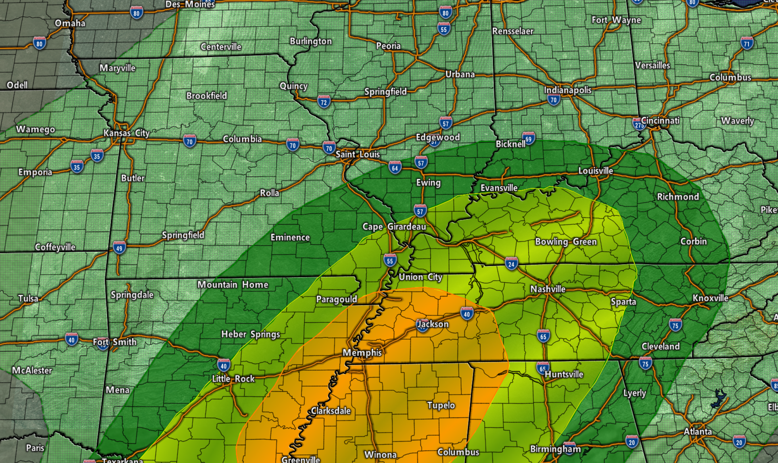
The SPC has outlined this area for severe. The orange is the highest risk. Yellow is the next highest and so on.
Bottom line is that we may have to deal with severe storms on Saturday.
What does a conditional risk mean?
It means that if we don’t have CAPE then we don’t have severe weather.
What is CAPE? CAPE is basically energy that builds in the atmosphere. It is what thunderstorms tap into to become severe.
We will have strong wind shear tomorrow and high dew points. Both are ingredients for severe weather.
IF CAPE does develop then we will have severe storms.
Damaging wind is a concern. Tornadoes would also be a concern.
Again, a conditional risk.
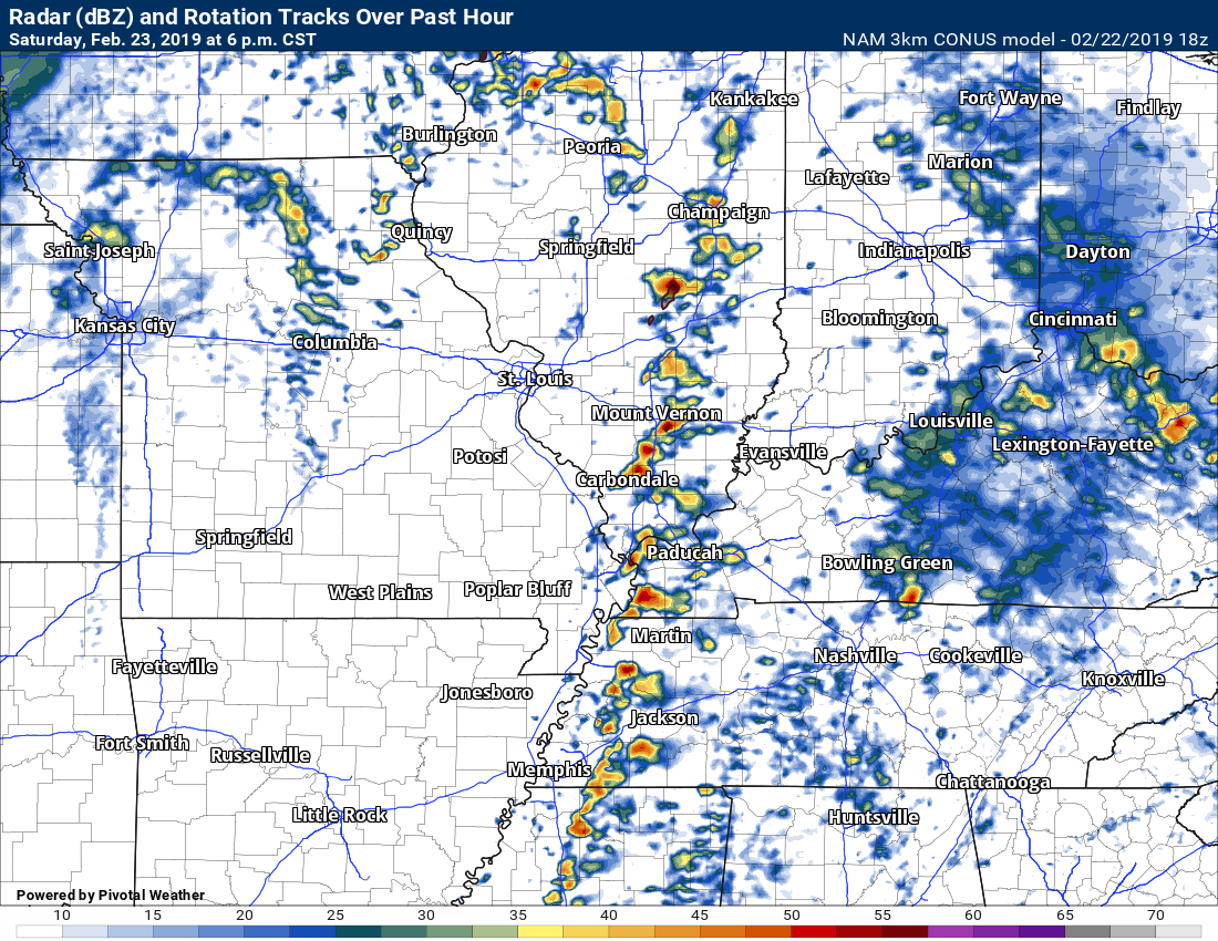
The NAM model shows supercell thunderstorms in our area tomorrow afternoon. That would mean damaging winds and possibly tornadoes.
Again, conditional risk. Not a sure bet.
Future-cast radar. There are timing differences in the model guidance. Some show storms earlier. This is 6 PM. NAM is later than some models.

Click one of the links below to take you directly to each section.
-
- Go to today’s forecast
- Go to the winter storm and severe weather outlook
- Go to the weather forecast discussion
- Go to the model future-cast radars
- Go to videos
- Go to weeks one, two, three, and four temperature and precipitation graphics
- Go to Weatherbrains
- View some of our charity work. Your subscription dollars help support these causes.

Even if your account has expired you WOULD still receive app/text messages. I have to manually stop them even if your payment method has expired.
Log into your account at this link www.weathertalk.com
Have questions? Email me at beaudodson@usawx.com
Thank you.
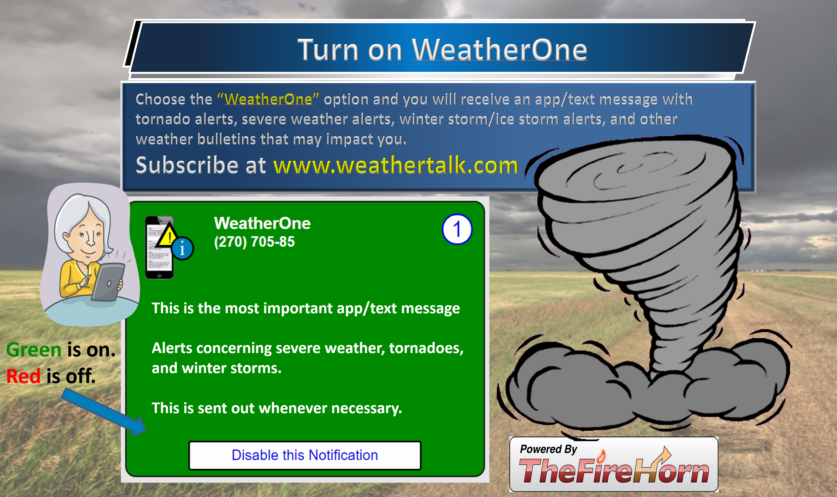
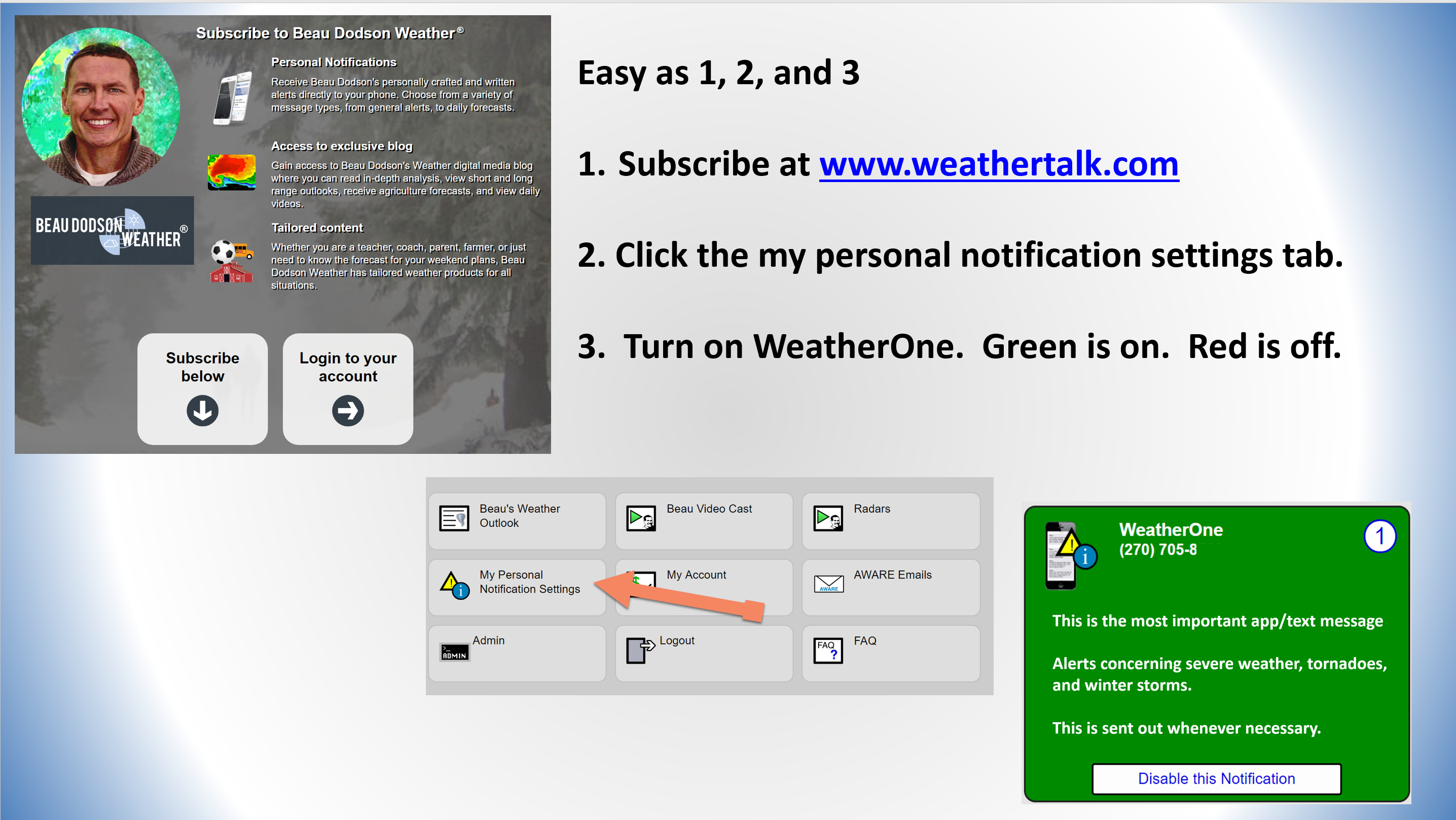
Not receiving app/text messages?
- Make sure you have the correct app/text options turned on. Do that under the personal notification settings tab at www.weathertalk.com. Red is off. Green is on.
- USE THE APP. Verizon and ATT have been throttling text messages. The app receives the same messages instantly. Texts can take longer. Please, use the app. It is under Beau Dodson Weather in the app stores.

Radar Link: Interactive local city-view radars & regional radars.
You will also find clickable warning and advisory buttons on the local city-view radars.
If the radar is not updating then try another one. If a radar does not appear to be refreshing then hit Ctrl F5. You may also try restarting your browser.
Not working? Email me at beaudodson@usawx.com
A quick look at the seven-day forecast.
My text forecast below these graphics may vary a bit.
I made the blog free today. I wanted everyone to see the changes. If you would like to subscribe then please go to www.weathertalk.com and then follow the setup process.
Click here if you would like to return to the top of the page
.
Missouri


Illinois


Kentucky


Tennessee


- Flash flooding potential tonight into Saturday evening.
- A few strong storms possible Saturday. Monitor updates.

Today: Yes. Locally heavy rain tonight could cause flooding. Avoid flooded roadways.
Tomorrow: Yes. Flash flooding is possible on Saturday. There could be some intense storms on Saturday, as well. Have WeatherOne turned on in your www.weathertalk.com accounts. These are for tornado alerts (among other alerts).
* What is a weather alert day? It is a day when flooding, severe weather, or wintry precipitation may impact your day.

Confidence rating explained.
- High confidence is 70% to 100%. This means that the forecast is likely to verify.
- Medium confidence is 40% through 60%. This means that there could be adjustments in the forecast.
- Low confidence is 0% to 30%. This means that dramatic changes in the forecast are likely.
Click here if you would like to return to the top of the page

Today through Sunday night.
Monitor the Saturday forecast. Severe storms can’t be ruled out.
- Is accumulating snow or ice in the forecast today through Sunday night? No.
- Is lightning in the forecast today through Sunday night? Yes. Lightning is possible Friday night into Saturday night.
- Is severe weather in the forecast today through Sunday night? Yes. Some storms could be intense on Saturday afternoon. Monitor updates.
* The NWS officially defines severe weather as 58 mph wind or great, 1″ hail or larger, and/or tornadoes - Is Flash flooding in the forecast today through Sunday night? Yes. Some flooding and/or flash flooding is possible Friday night and Saturday. Monitor updates, watches, and warnings.

Monday through Thursday.
- Is accumulating snow or ice in the forecast Monday through Thursday? Possible. Let’s monitor Wednesday night. Some flurries or snow showers are possible Tuesday and Wednesday night.
- Is lightning in the forecast Monday through Thursday? No.
- Is severe weather in the forecast Monday through Thursday? No.
* The NWS officially defines severe weather as 58 mph wind or great, 1″ hail or larger, and/or tornadoes - Is flash flooding in the forecast Monday through Thursday? No.
* The Missouri Bootheel includes Dunklin, New Madrid, and Pemiscot Counties
* Northwest Kentucky includes Daviess, Henderson, McLean Union, and Webster Counties
.
February 22, 2019
This is the preliminary update. The full update will be posted at 8 AM.
Friday’s Forecast: Cloudy with scattered showers.
My confidence in the forecast verifying: High (70% confidence in the forecast)
Temperature range: MO Bootheel 50° to 52° SE MO 48° to 52° South IL 48° to 52° Northwest KY (near Indiana border) 46° to 50° West KY 50° to 52° NW TN 50° to 54°
Wind direction and speed: East and northeast at 10 to 15 mph
Wind chill or heat index (feels like) temperature forecast: 44° to 54°
What is the chance/probability of precipitation? MO Bootheel 70% Southeast MO 60% Southern IL 50% Northwest KY (near Indiana border) 50% Western KY 60% NW TN 70%
Note, what does the % chance actually mean? A 20% chance of rain does not mean it won’t rain. It simply means most areas will remain dry.
Coverage of precipitation: Scattered
What impacts are anticipated from the weather? Wet roadways.
Should I cancel my outdoor plans? Monitor radars. Have a plan B. Some showers will dot radar.
UV Index: 2 Low
Sunrise: 6:36 AM
Friday night Forecast: Showers and thunderstorms developing. Locally heavy rain, especially from the Missouri Bootheel into parts of western Kentucky and Tennessee. Rising temperatures overnight.
My confidence in the forecast verifying: High (70% confidence in the forecast)
Temperature range: MO Bootheel 48° to 50° SE MO 42° to 44° South IL 42° to 45° Northwest KY (near Indiana border) 44° to 48° West KY 46° to 52° NW TN 48° to 54°
Wind direction and speed: East and southeast at 5 to 10 mph with gusts to 15
Wind chill or heat index (feels like) temperature forecast: 38° to 44°
What is the chance/probability of precipitation? MO Bootheel 100% Southeast MO 70% Southern IL 70% Northwest KY (near Indiana border) 70% Western KY 90% NW TN 100%
Note, what does the % chance actually mean? A 20% chance of rain does not mean it won’t rain. It simply means most areas will remain dry
Coverage of precipitation: Numerous
What impacts are anticipated from the weather? Wet roadways. Lightning. Flooded roadways. Flash flooding possible where heavier rain occurs.
Should I cancel my outdoor plans? Have a plan B
Sunset: 5:42 PM
Moonrise: 9:29 PM
The phase of the moon: Waning Gibbous
Moonset: 8:45 AM
February 23, 2019
Saturday’s Forecast: Note: It would not take much wind to bring trees down. Soils are super-saturated. Wind gusts of 40 or 50 mph would topple some trees. Keep this in mind. Warm. Showers and heavy thunderstorms. Locally heavy rain. Some storms could be intense.
My confidence in the forecast verifying: Medium (60% confidence in the forecast)
Temperature range: MO Bootheel 66° to 70° SE MO 64° to 68° South IL 66° to 68° Northwest KY (near Indiana border) 66° to 68° West KY 66° to 68° NW TN 66° to 70°
Wind direction and speed: South and southeast at 15 to 30 mph and gusty.
Wind chill or heat index (feels like) temperature forecast: N/A° to N/A°
What is the chance/probability of precipitation? MO Bootheel 100% Southeast MO 100% Southern IL 90% Northwest KY (near Indiana border) 100% Western KY 100% NW TN 100%
Note, what does the % chance actually mean? A 20% chance of rain does not mean it won’t rain. It simply means most areas will remain dry.
Coverage of precipitation: At times, numerous
What impacts are anticipated from the weather? Wet roadways. Flooded roadways. Flash flooding. Lightning. Strong winds. If severe storms do develop then damaging winds and even tornadoes will be possible. Again, monitor updates. Monitor the severe weather risk.
Should I cancel my outdoor plans? Have a plan B
UV Index: 2 Low
Sunrise: 6:34 AM
Saturday night Forecast: Showers and heavy thunderstorms ending west to east. A few intense storms are possible during the evening hours. Windy. Turning cooler.
My confidence in the forecast verifying: Medium (60% confidence in the forecast)
Temperature range: MO Bootheel 40° to 45° SE MO 35° to 40° South IL 35° to 40° Northwest KY (near Indiana border) 38° to 42° West KY 38° to 42° NW TN 40° to 45°
Wind direction and speed: Southwest becoming west and northwest at 15 to 30 mph and gusty.
Wind chill or heat index (feels like) temperature forecast: 25° to 35°
What is the chance/probability of precipitation? MO Bootheel 40% Southeast MO 40% Southern IL 60% Northwest KY (near Indiana border) 60% Western KY 80% NW TN 70%
Note, what does the % chance actually mean? A 20% chance of rain does not mean it won’t rain. It simply means most areas will remain dry
Coverage of precipitation: Numerous early. Ending west to east.
What impacts are anticipated from the weather? Wet roadways. Lightning. Strong winds. If severe storms do devclop then damaging winds and even tornadoes will be possible. Again, monitor updates. Monitor the severe weather risk.
Should I cancel my outdoor plans? Have a plan B
Sunset: 5:43 PM
Moonrise: 10:35 PM
The phase of the moon: Waning Gibbous
Moonset: 9:19 AM
February 24, 2019
Sunday’s Forecast: Decreasing clouds. Becoming mostly sunny. Windy.
My confidence in the forecast verifying: High (80% confidence in the forecast)
Temperature range: MO Bootheel 50° to 55° SE MO 48° to 52° South IL 46° to 50° Northwest KY (near Indiana border) 48° to 52° West KY 50° to 54° NW TN 50° to 55°
Wind direction and speed: West winds 15 to 30 mph and gusty.
Wind chill or heat index (feels like) temperature forecast: 40° to 45°
What is the chance/probability of precipitation? MO Bootheel 0% Southeast MO 0% Southern IL 0% Northwest KY (near Indiana border) 0% Western KY 0% NW TN 0%
Note, what does the % chance actually mean? A 20% chance of rain does not mean it won’t rain. It simply means most areas will remain dry.
Coverage of precipitation: None
What impacts are anticipated from the weather? There could still be ongoing flooding from Saturday night’s rain. Of course, river flooding will continue for a while..
Should I cancel my outdoor plans? No
UV Index: 4 moderate
Sunrise: 6:33 AM
Sunday night Forecast: Mostly clear. Some passing clouds. Chilly. Patchy fog.
My confidence in the forecast verifying: High (80% confidence in the forecast)
Temperature range: MO Bootheel 28° to 34° SE MO 25° to 30° South IL 25° to 30° Northwest KY (near Indiana border) 28° to 32° West KY 28° to 34° NW TN 30° to 34°
Wind direction and speed: West and northwest at 7 to 14 mph
Wind chill or heat index (feels like) temperature forecast: 20° to 25°
What is the chance/probability of precipitation? MO Bootheel 0% Southeast MO 0% Southern IL 0% Northwest KY (near Indiana border) 0% Western KY 0% NW TN 0%
Note, what does the % chance actually mean? A 20% chance of rain does not mean it won’t rain. It simply means most areas will remain dry
Coverage of precipitation: None
What impacts are anticipated from the weather? None
Should I cancel my outdoor plans? No
Sunset: 5:44 PM
Moonrise: 11:41 PM
The phase of the moon: Waning Gibbous
Moonset: 9:54 AM
Learn more about the UV index readings. Click here.
Monday: Mostly sunny. Highs in the upper 40’s to middle 50’s. Lows Monday night in the upper 30’s to middle 40’s.
Tuesday: Partly sunny. A chance of light rain or snow showers Tuesday night. Highs in the 50’s. Lows Tuesday night in the 30’s.
Wednesday: A chance of showers. A chance of snow flurries Wednesday night. Highs in the 40’s. Lows Tuesday night in the 20’s.
Thursday: Partly cloudy. Highs in the 40’s. Lows Tuesday night in the 20’s.
The wind speed and direction forecast
This will be posted at 8 AM.

The National Weather Service defines a severe thunderstorm as one that produces quarter size hail or larger, 58 mph winds or greater, and/or a tornado.
Friday through Sunday: Lightning will occur Friday night and Saturday. Some storms could be intense on Saturday. Monitor any watches and/or warnings that are issued on Saturday.
If severe storms do develop then damaging winds and even tornadoes will be possible. Again, monitor updates.
Note: It would not take much wind to bring trees down. Soils are super-saturated. Wind gusts of 40 or 50 mph would topple some trees. Keep this in mind.
Make sure you turn on your severe weather/tornado alert app/text messages. See how to do that further down in this weather update.

Today through Friday: I am monitoring Tuesday night and Wednesday night for some flurries or snow showers.
.
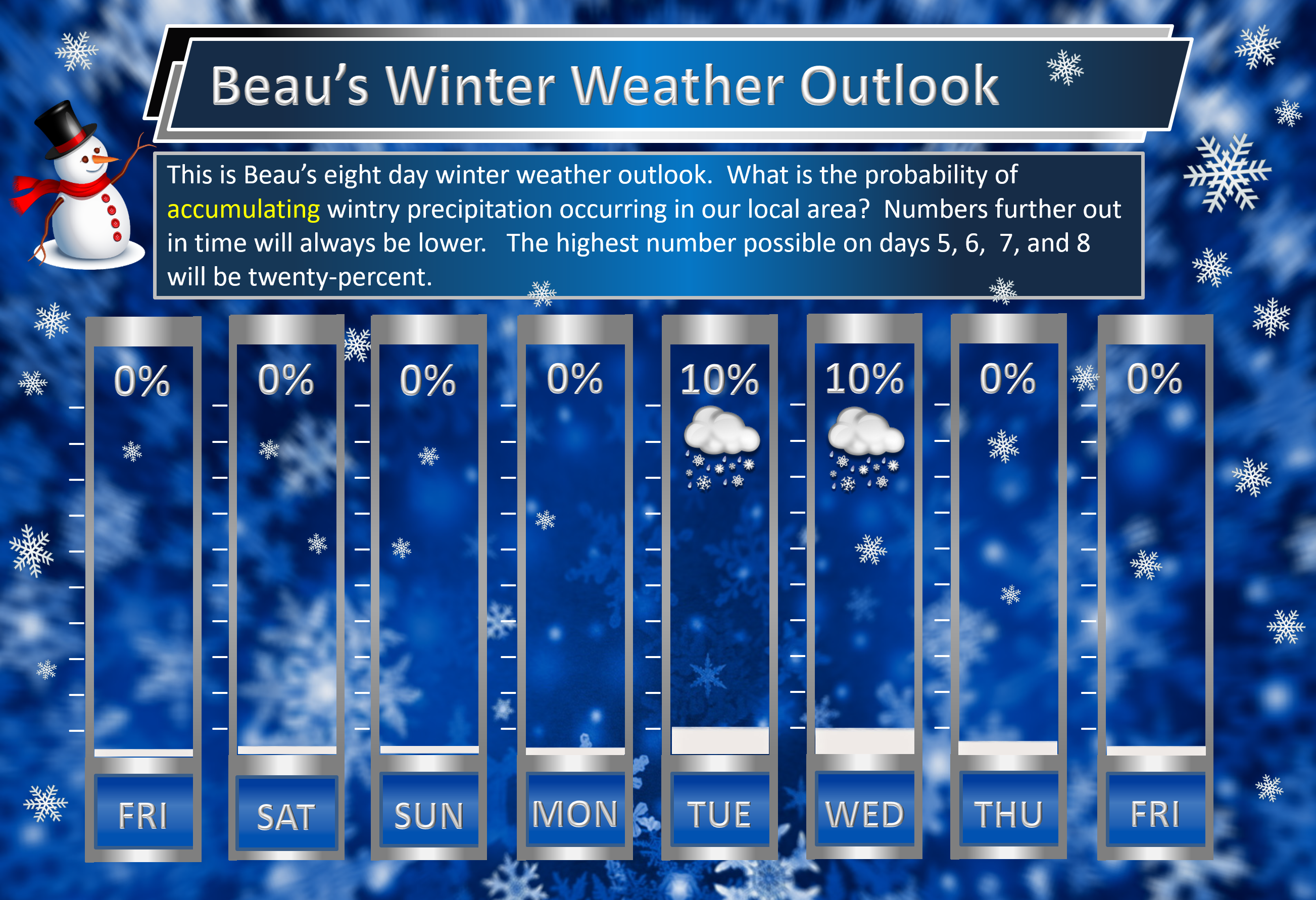
Beau’s exclusive eight-day winter weather outlook
The highest probability on days 5, 6, 7, and 8 will be twenty-percent.
Keep in mind, this includes sleet and freezing rain.

Here is the latest graphic from the WPC/NOAA.
This map shows you liquid and does not assume precipitation type. In other words, melted precipitation totals.
There are some major disagreements among the model guidance concerning rain totals.
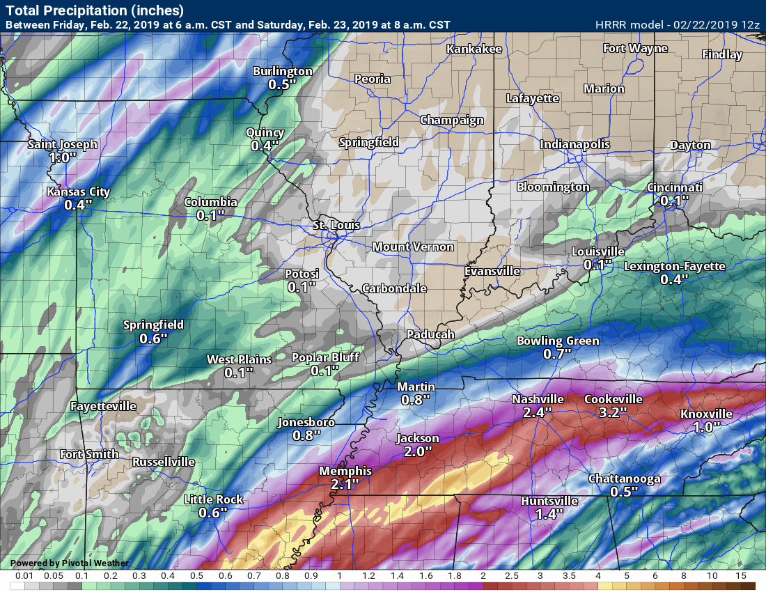
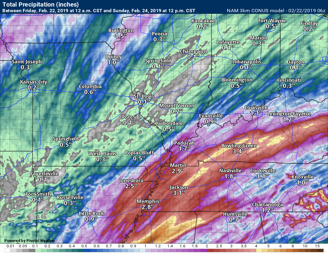
Check out these three images.
The Hrrr model, the NAM model, and the GFS model.
This does concern me a little bit (from an accurate forecast point of view). The model guidance seems to have shifted the heavier rain quite a bit southward.
I am going to monitor trends today.
For now, monitor updates and plan on locally heavy rain with this system. This is especially true from the Missouri Bootheel into parts of western Kentucky and Tennessee.
This first grapic is only through 8 AM Saturday.
This is through Sunday
This is through Sunday
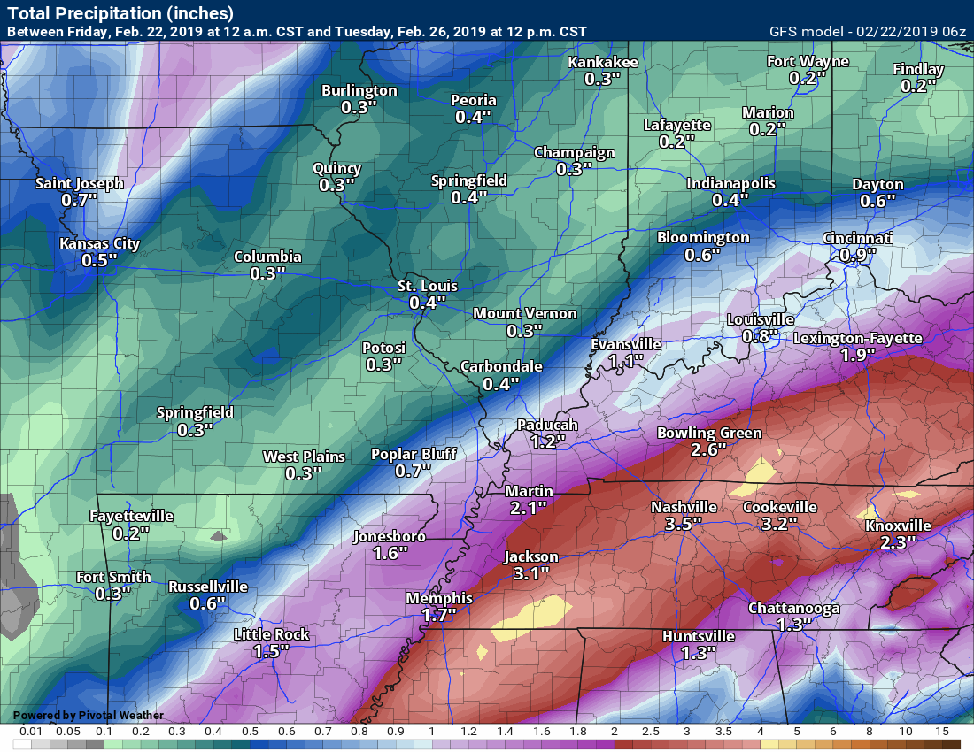
48-hour NOAA/WPC precipitation outlook.

Here is the seven-day precipitation forecast. This includes day one through seven. This is from the WPC/NOAA.

Subscribers, do you need a forecast for an outdoor event?

Did you know that you can find me on Twitter? Click here to view my Twitter weather account.

Interactive live weather radar page. Choose the city nearest your location. If one of the cities does not work then try a nearby one. Click here.
National map of weather watches and warnings. Click here.
Storm Prediction Center. Click here.
Weather Prediction Center. Click here.

Live lightning data: Click here.

Interactive GOES R satellite. Track clouds. Click here.
GOES 16 slider tool. Click here.

Here are the latest local river stage forecast numbers Click Here.
Here are the latest lake stage forecast numbers for Kentucky Lake and Lake Barkley Click Here.

- Shower chances increase today.
- Widespread showers and thunderstorms Friday night into Saturday evening. Generally, another 0.75 to 1.5″ of rain. Pockets of greater than 2″ likely.
- Monitor the risk of intense thunderstorms on Saturday. If severe storms do develop then damaging winds and even tornadoes will be possible. Again, monitor updates.
- Note: It would not take much wind to bring trees down. Soils are super-saturated. Wind gusts of 40 or 50 mph would topple some trees. Keep this in mind.
Have there been any changes in the forecast over the last 24 hours?
I am concerned that some models have shifted the heaviest rain totals quite a bit southward.
I did adjust region-wide rain totals a bit.
Otherwise, no major changes.
Does the forecast require action?
Yes. Avoid flooded roadways.
Yes. Monitor the risk of heavy rain, Some storms could be intense on Saturday. If severe storms do develop then damaging winds and even tornadoes will be possible. Again, monitor updates. This is a conditional risk (if we don’t have enough instability then severe storms won’t form).
Yes. Note: It would not take much wind to bring trees down. Soils are super-saturated. Wind gusts of 40 or 50 mph would topple some trees. Keep this in mind.
Widespread river flooding continues across the region.
Click here if you would like to return to the top of the page
Forecast discussion.
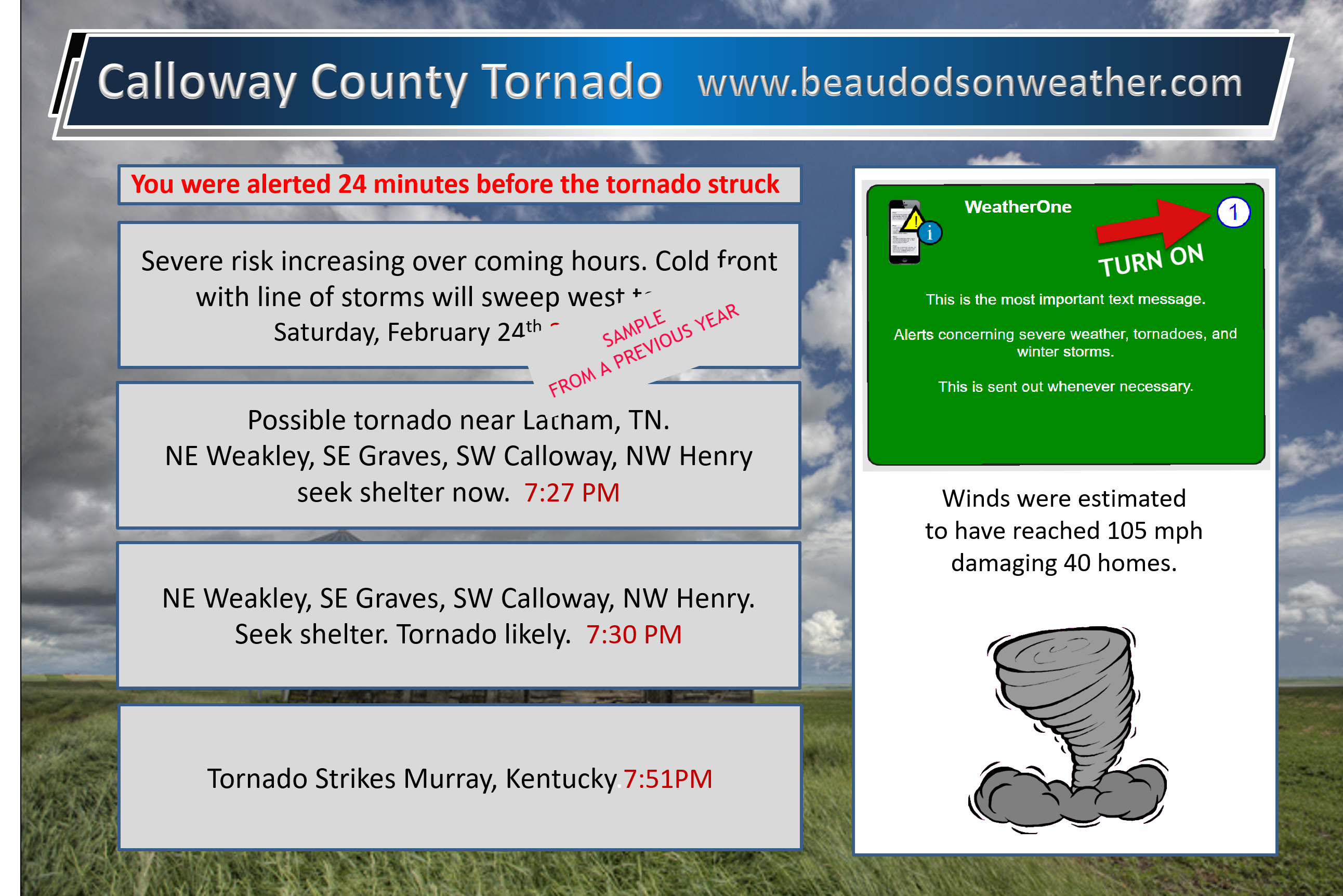
WeatherTalk subscribers, check your severe weather settings. Make sure your tornado alerts are turned on.
First, check your www.weathertalk.com settings.
Make sure you have turned on WeatherOne in your www.weathertalk.com accounts.
Samples from previous events.
We have been averaging 5 to 10 minutes ahead of other sources. Always have three or four sources to receive severe weather information. Do not rely on just one.
Click these images to enlarge them.
.
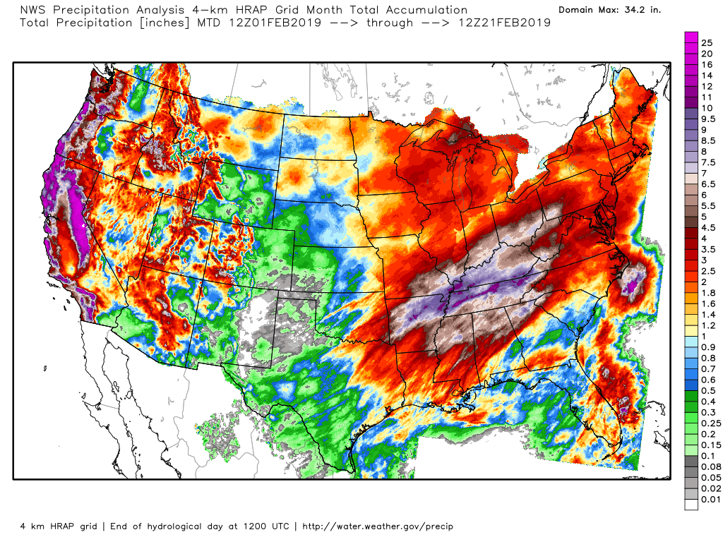
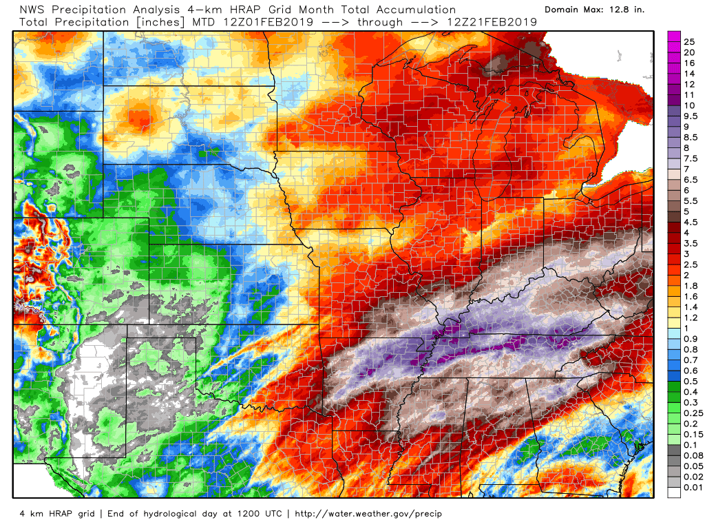
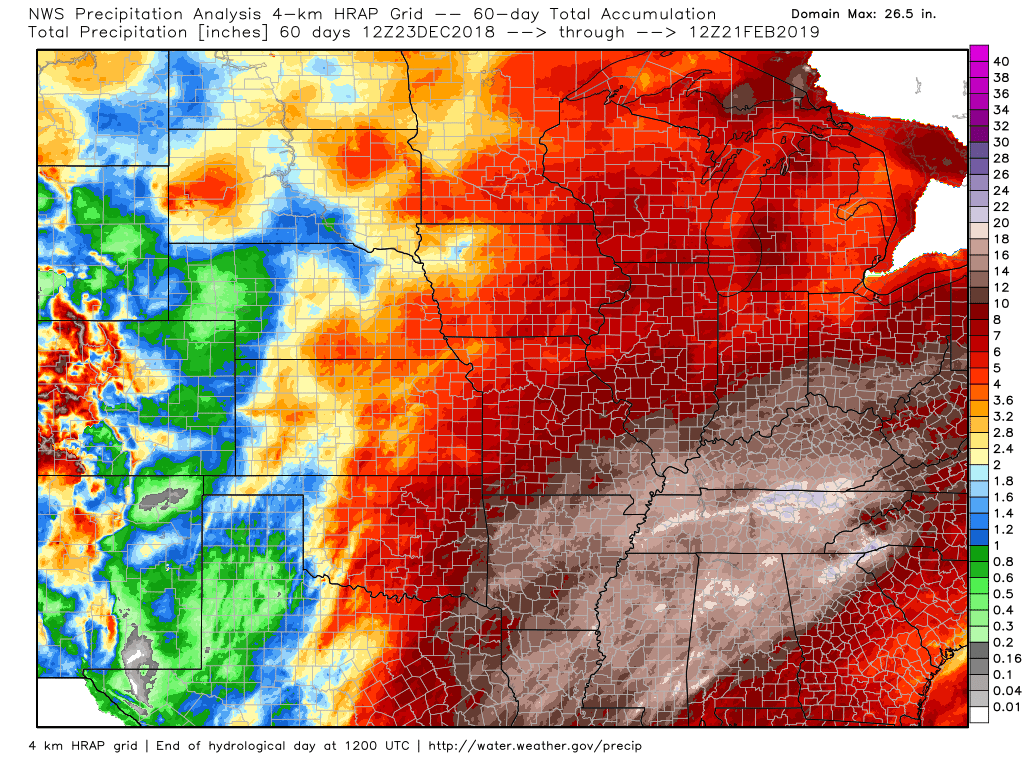
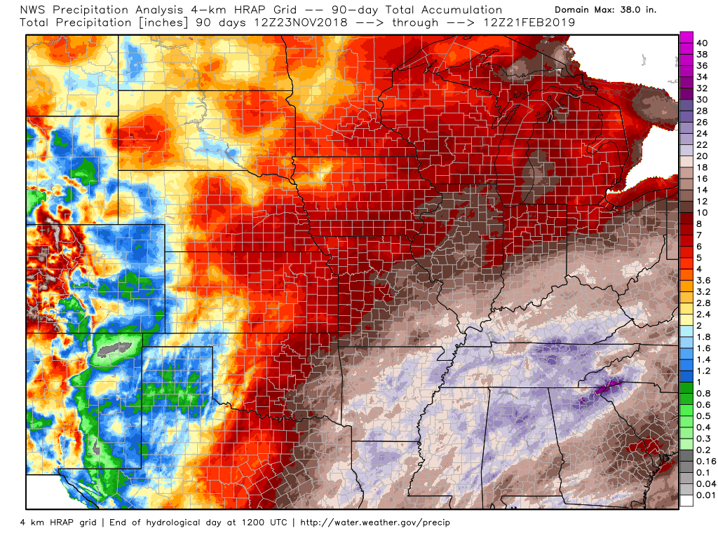
Rain, rain, rain.
I wanted to show you some amazing rainfall graphics. This is what has already fallen.
These first two graphics are the month to date rainfall totals.
Zoomed in.
These next two graphics are the percent of normal and deviation from normal precipitation numbers.
Extremely impressive coverage of above normal precipitation. This is a major concern for spring flood season.
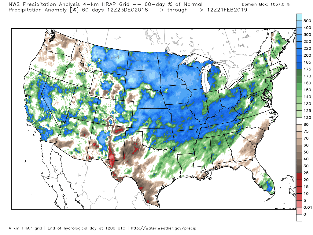
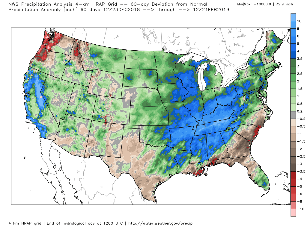
How much rain fell over the last 60 days?
How much rain fell in the last 90 days?
Another heavy rain event is already on the way. Strong storms are possible, as well.
The heaviest rain will likely fall from the Missouri Bootheel and then into parts of western Kentucky and western Tennessee. Lesser amounts as you move northward.
A widespread 0.75″ to 1.5″ of rain is likely across the region. Pockets of greater than 2″ likely.

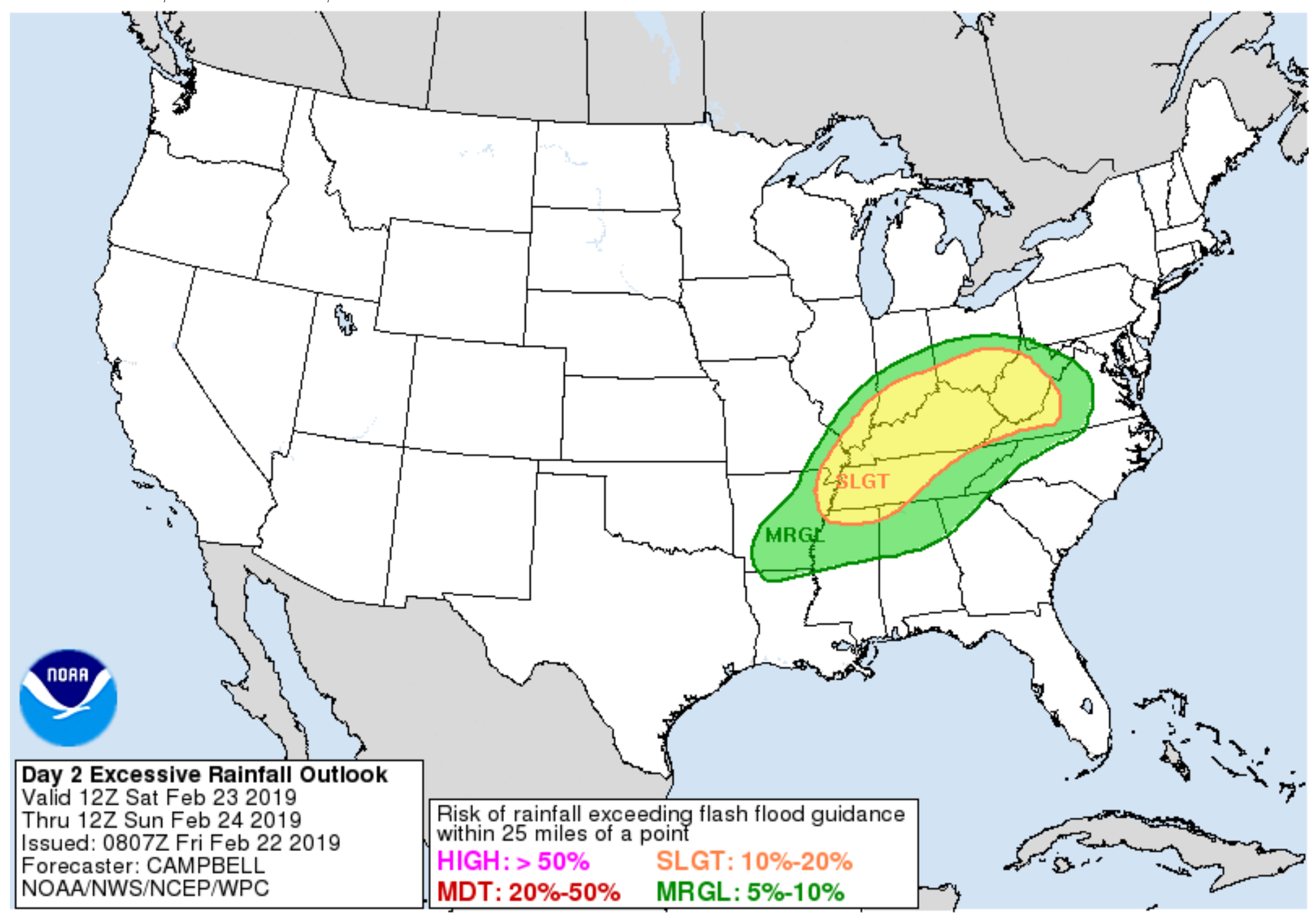
The WPC/NOAA has outlined our region for a marginal and slight risk of excessive rainfall today and a larger risk on Saturday.
Today’s outlook (this means that rain totals may be enough to trigger flooding)
Click to enlarge
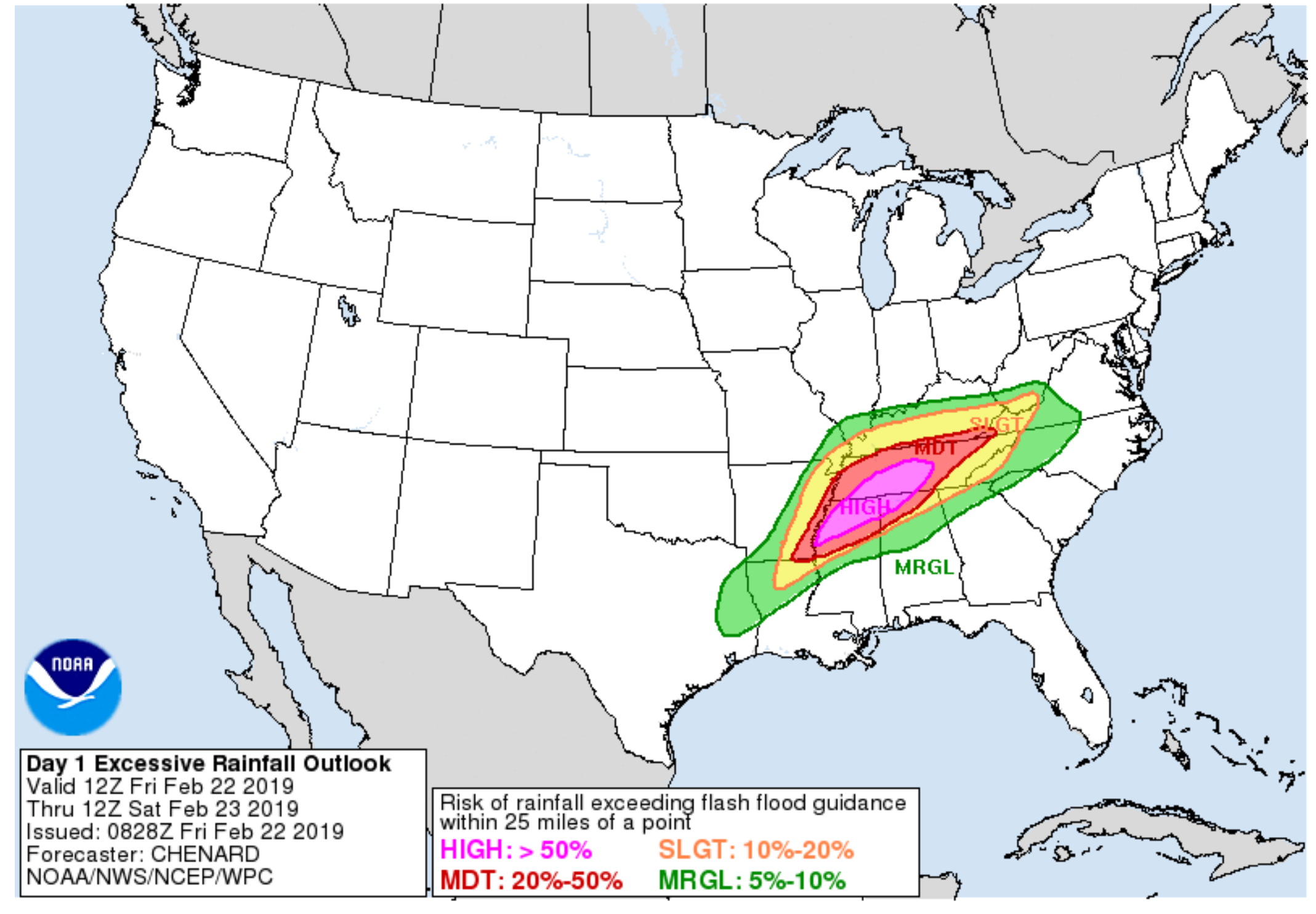
And tomorrow
You can see the moderate risk pushes close to the KY/TN border. Either way, heavy rain is likely with this event.
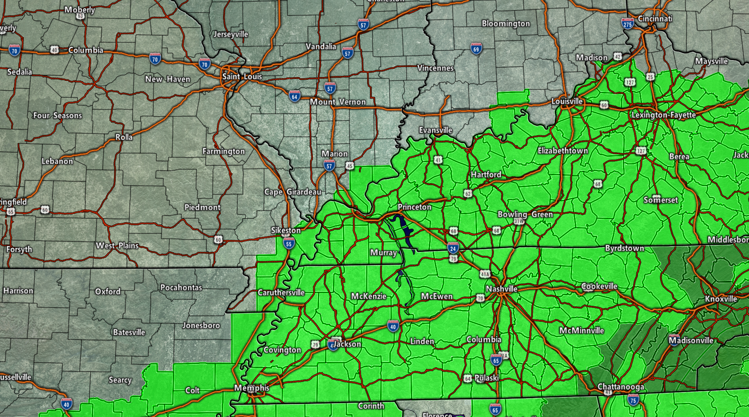
Flash flood watch in bright green. This will run from this evening into Saturday evening.
Today
Some light showers are possible today. Rain totals will be less than 0.20″. Some areas may remain completely dry.
Best chance of rain will be from the Missouri and Arkansas border into western Kentucky and Tennessee. Chances decrease as you move further north.
Tonight
Widespread showers and locally heavy thunderstorms will develop tonight. Flash flooding is possible where thunderstorms train over the same areas. Heaviest rain may hold off until after midnight.
The heaviest rain may occur after midnight.
Model guidance has backed down a bit on the rainfall numbers. I am going to monitor trends today.
For now, it appears a widespread 0.75: to 1.5″ of rain is likely across the region with pockets of greater than 2″ of rain likely.
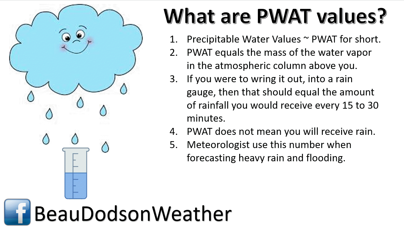
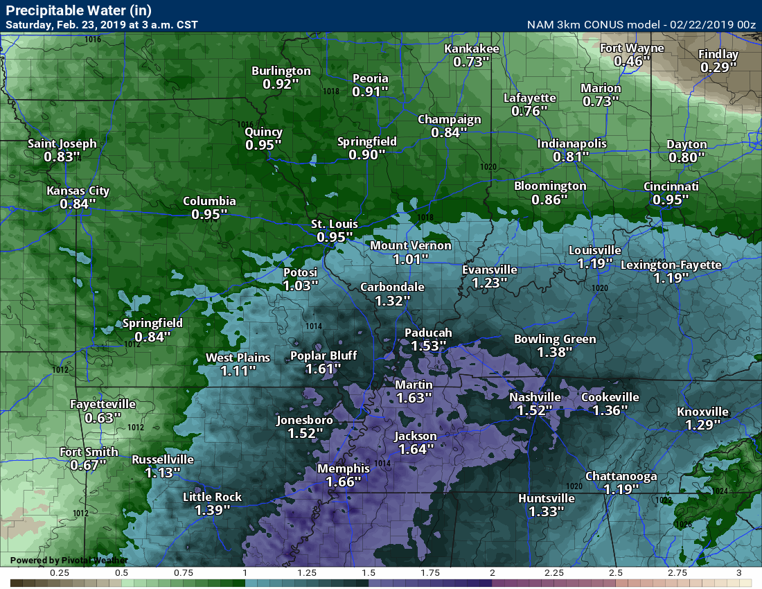
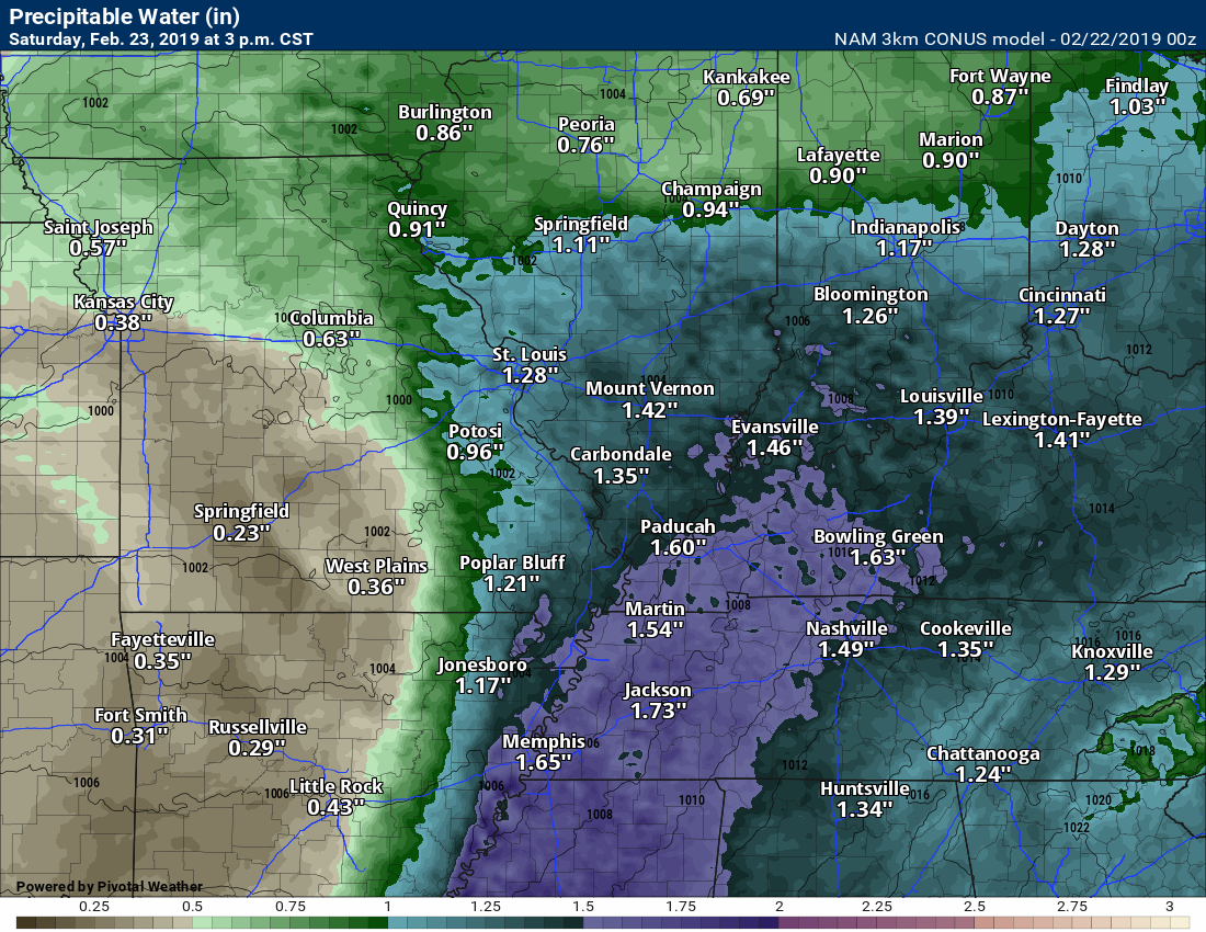
There will be a lot of moisture in the atmosphere. Thunderstorms will tap into the high PWAT values (PWAT is a measure of moisture).
These are well above normal PWAT values.
Click graphics to enlarge them.
This one is for late tonight. That is a lot of moisture.
Tomorrow at 3 PM. Again, high numbers.
A few severe thunderstorms are possible on Saturday.
If you have plans this weekend then pay a bit more attention to what is going on weather-wise. Storms will be moving at speeds in excess of 65 mph.
There could be some intense thunderstorms on Saturday. The risk is dependent on cloud cover thinning. A greater risk may occur in Arkansas into Tennessee, Mississippi, and Alabama.
Our region is not excluded. If severe storms do develop then damaging winds and even tornadoes will be possible. Again, monitor updates.
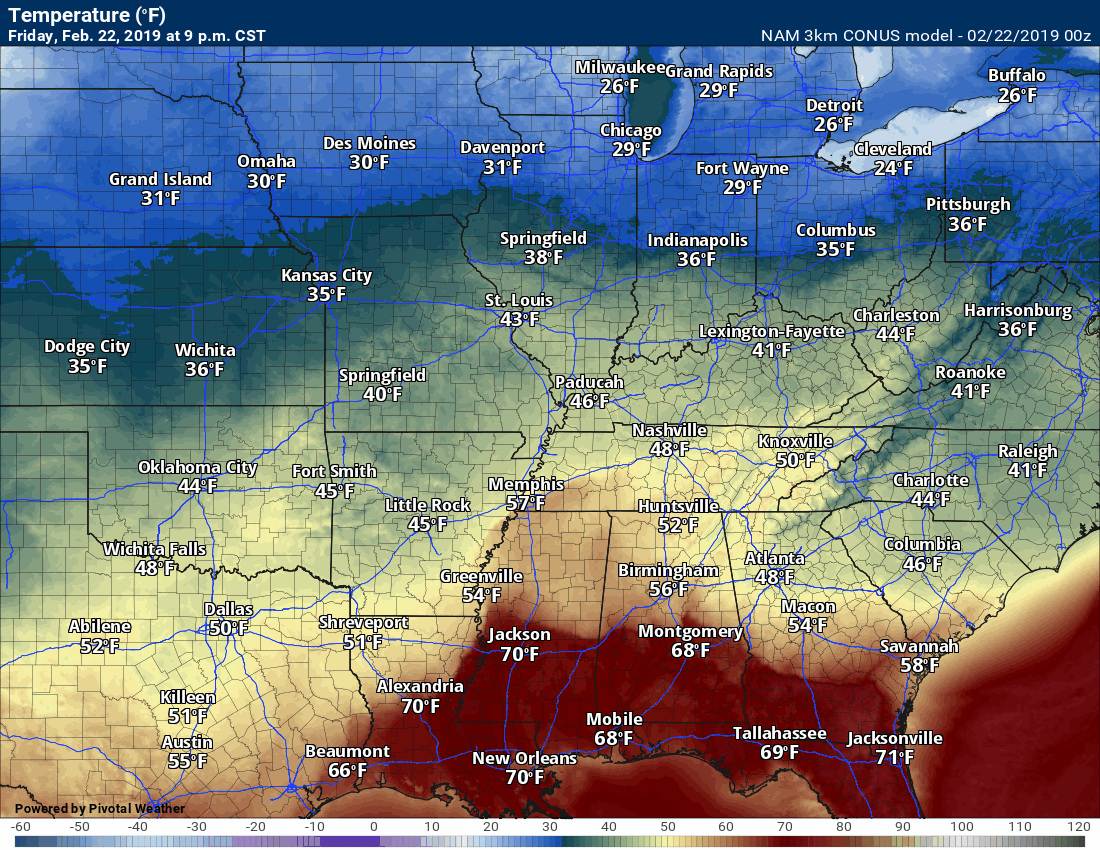
Check out this temperature animation.
Watch the surge of warm air ahead of the cold front. Low pressure rotates counter-clockwise. A low to our west/northwest would pull warm air northward. That is what will happen this weekend.
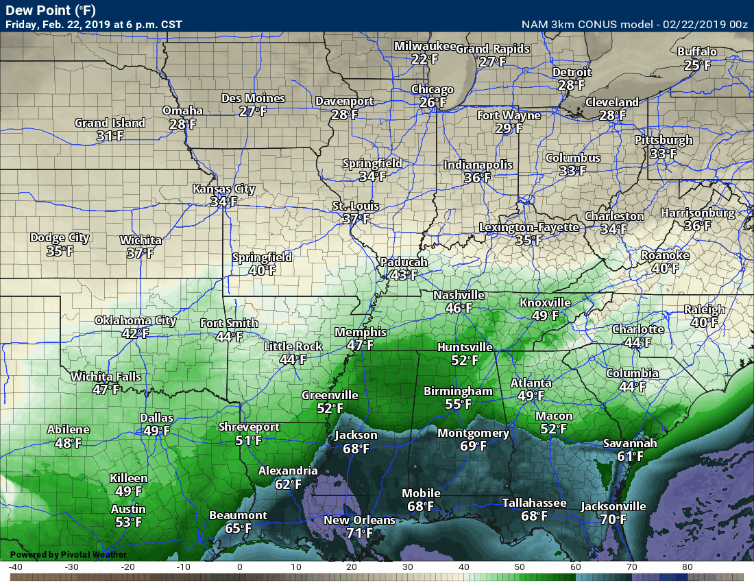
Here is the dew point map.
The low will pull moisture rapidly northward from the Gulf of Mexico. It will move up the Mississippi River Delta.
Dew point is a measure of moisture. We look for 58 degrees and above during the winter months when considering severe weather forecasting.
The forecast is for dew points to be in the 60’s. Plenty of moisture for thunderstorms to tap into.
Again, storms will be moving at speeds of 65+ mph. That is fast for thunderstorms.
There is one concern about forecasting severe thunderstorms Saturday afternoon and evening. The lack of CAPE. CAPE is a measure of energy in the atmosphere.
If CAPE does not develop then the risk of severe weather is lower. This raises questions about the severe weather part of the forecast.
We will not know this until Saturday. Why? Ongoing clouds and precipitation will squash CAPE.
Note: It would not take much wind to bring trees down. Soils are super-saturated. Wind gusts of 40 or 50 mph would topple some trees. Keep this in mind.
There should be numerous showers and thunderstorms throughout Saturday. This raises questions on whether instability will develop. Often times significant severe weather events are like this. All or nothing (severe, at least).
If the clouds thin and the sun comes out then CAPE will rapidly develop. That increases the risk of severe weather along the incoming cold front.
I would strongly suggest monitoring watches and warnings on Saturday. If CAPE does develop then large hail, damaging straight-line winds, and tornadoes will likely occur in and near our region.
Click here if you would like to return to the top of the page
Model Future-cast Radars
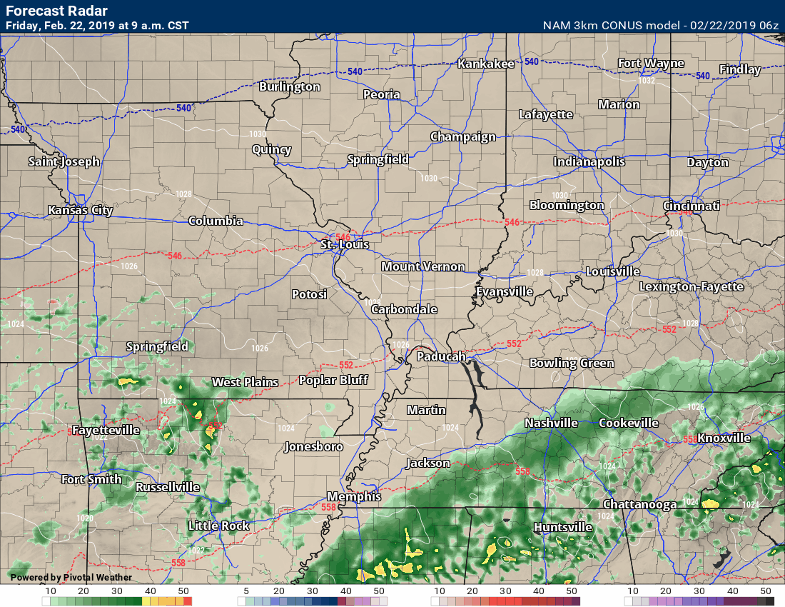
Here is the future-cast radar. You can see today’s showers develop from south to north. This also takes us into early Saturday afternoon.
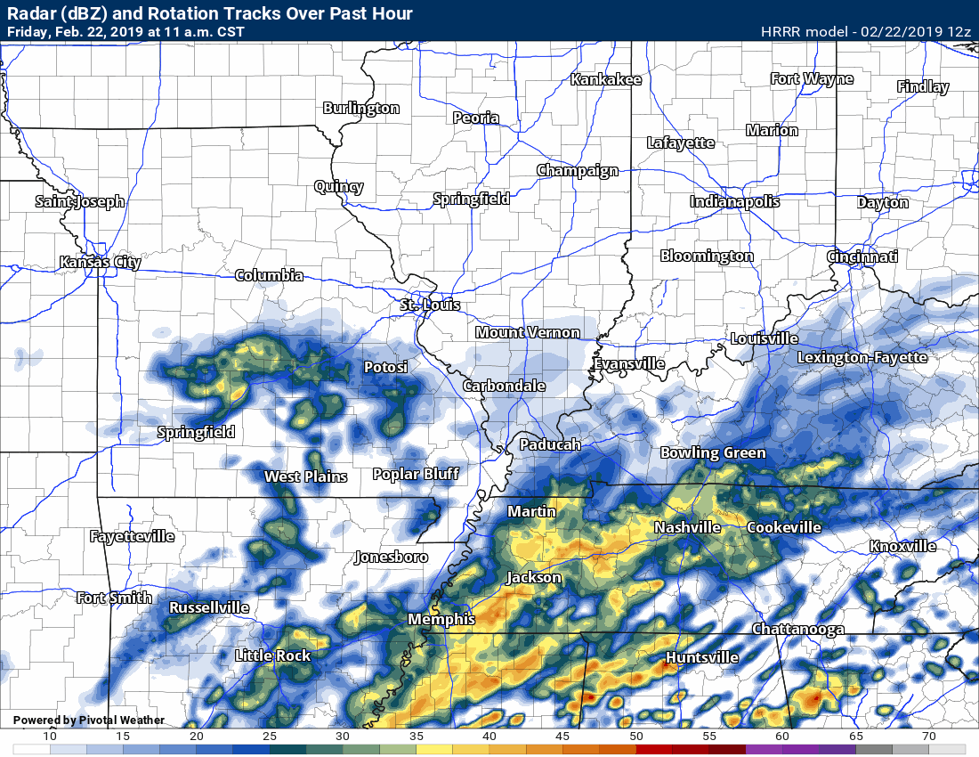
Here is the Hrrr model guidance. The Hrrr guidance shows significant severe weather on Saturday afternoon and evening.
.
Here is another view of the system that arrives today and Saturday. It is wound up tight. That blue area is a blizzard.
The low rapidly deepens as it moves out of Kansas into the upper Midwest and the Great Lakes. A classic blizzard/winter storm for some. Storms for others.
Click to enlarge.
Blue is snow. Dark blue is heavy snow. Pink would be a wintry mix. Green is rain. Dark green, yellow, and orange would be rain to heavy rain.
.
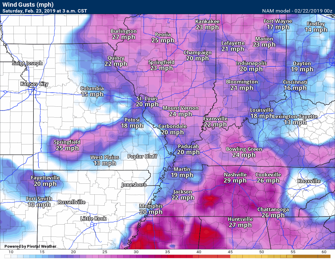
Strong and gusty winds will accompany the weekend storm.
The strongest winds (outside of storms) will be Saturday and Saturday night. Strong and gusty winds because of the tight pressure gradient.
Super-saturated ground conditions could mean that trees will topple if winds become strong and gusty.
.
Current conditions.

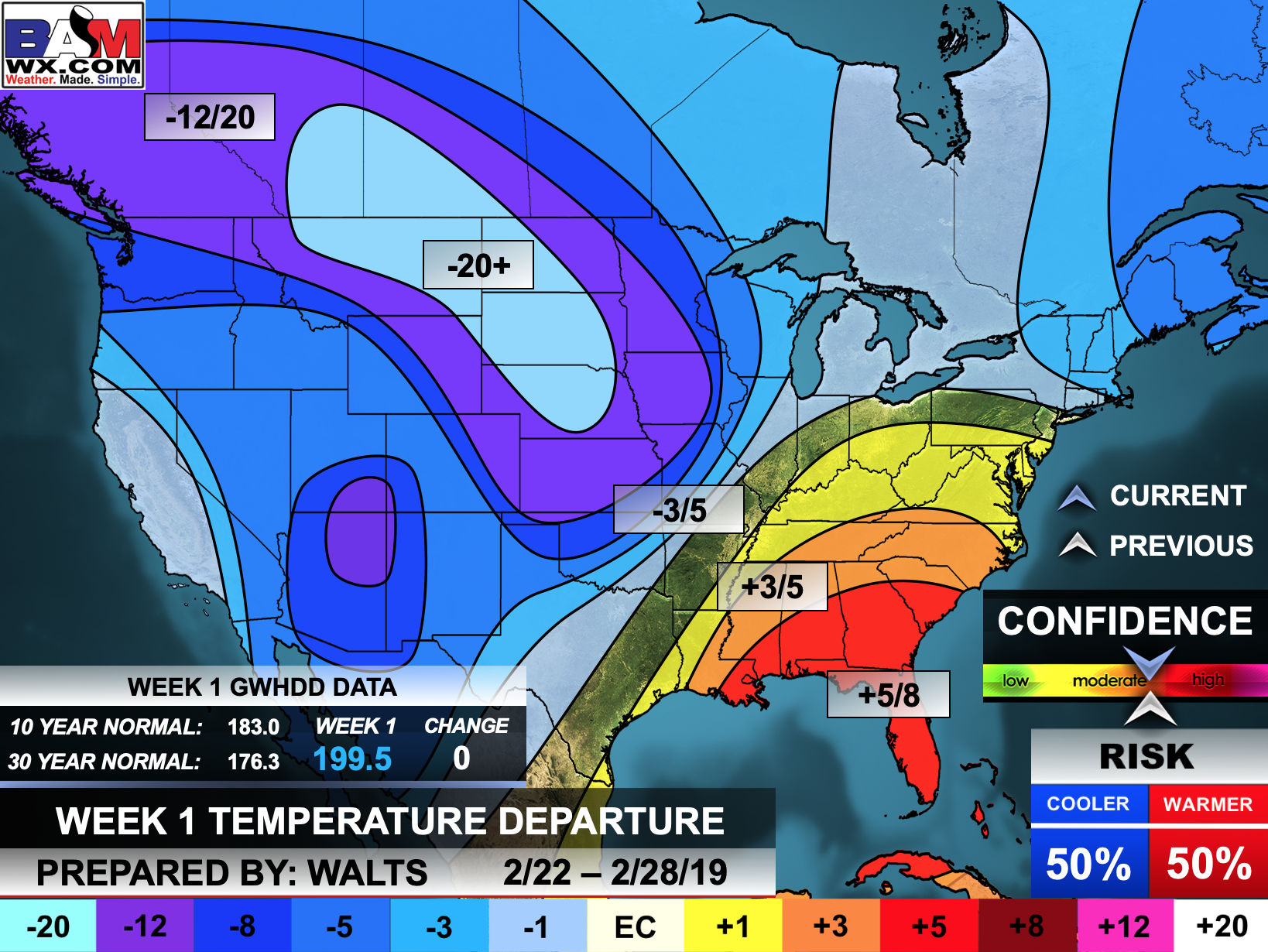
Forty-eight-hour temperature outlook.


Satellite
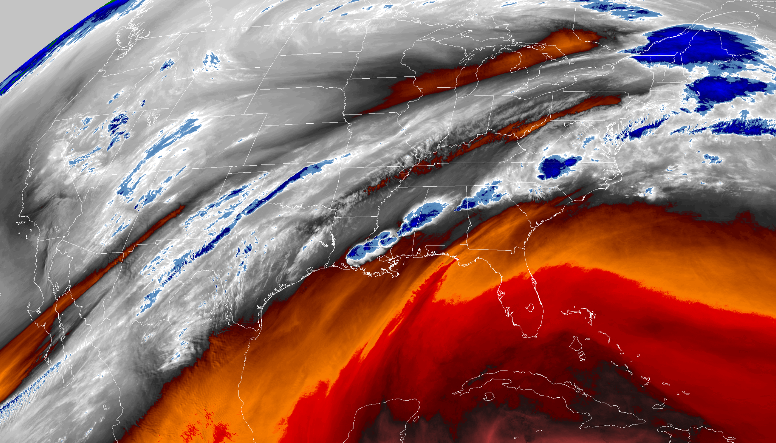
Today’s image is the IR satellite.
You can see the moisture moving our way from the southwest. This extends well back into the Pacific Ocean.
This feature has been there for days. Looks like it will be here for another 48 hours.
Interactive GOES R satellite. Track clouds. Click here.
![]()
These are bonus videos and maps for subscribers. I bring these to you from the BAMwx team. I pay them to help with videos.
The Ohio and Missouri Valley videos cover most of our area. They do not have a specific Tennessee Valley forecast but they may add one in the future.
The long-range video is a bit technical. Over time, you can learn a lot about meteorology from the long range video.
NOTE: These are usually not updated on Saturday or Sunday unless there is active weather.
Click here if you would like to return to the top of the page

The Ohio Valley video


This will be posted at 8 AM.
The Missouri Valley video (is usually updated during the late morning hours)
.![]()

Here is the latest WPC/NOAA 6 to 10 & 8 to 14-day temperature outlooks.
** NOTE: See our own more detailed in-house long-range forecast graphics below these. They may not always agree **
The cool colors indicate below normal temperatures. The darker the blue the greater the chance of below normal temperatures.
The warm colors represent the probability of above normal temperatures.
Days six through ten temperature outlook
Confidence % that it will be above or below normal?

Days six through ten precipitation outlook
Confidence % that it will be above or below normal?
The darker colors represent high confidence in above normal precipitation.

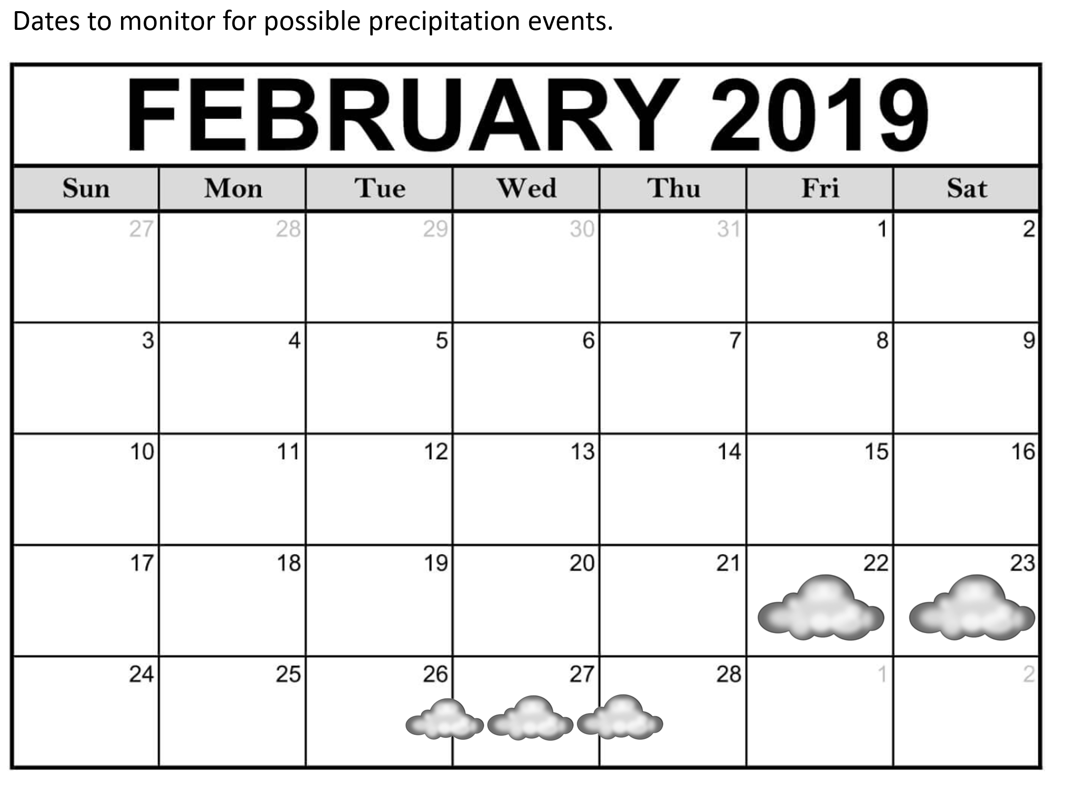
Days eight through fourteen temperature outlook
Confidence % that it will be above or below normal?

Days eight through fourteen precipitation outlook
Confidence % that it will be above or below normal?
The darker colors represent high confidence in above normal precipitation.

Remember, long-range outlooks are always going to be a lower confidence level than short-term forecasts.
Long-range forecasting is not an exact science. There are many variables that determine the eventual outcome of a long-range forecast.

.
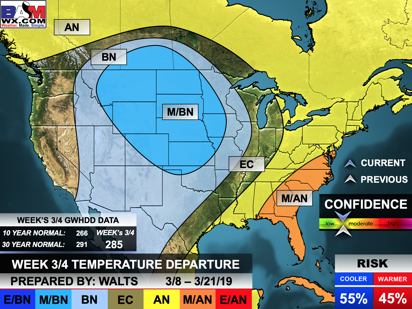
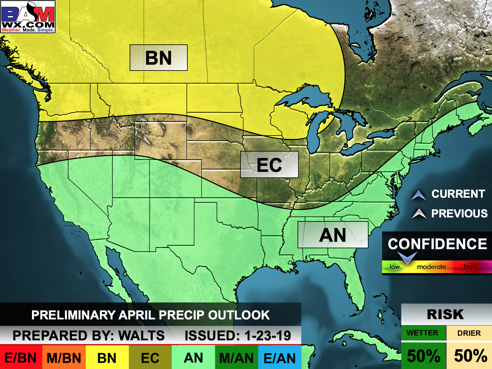
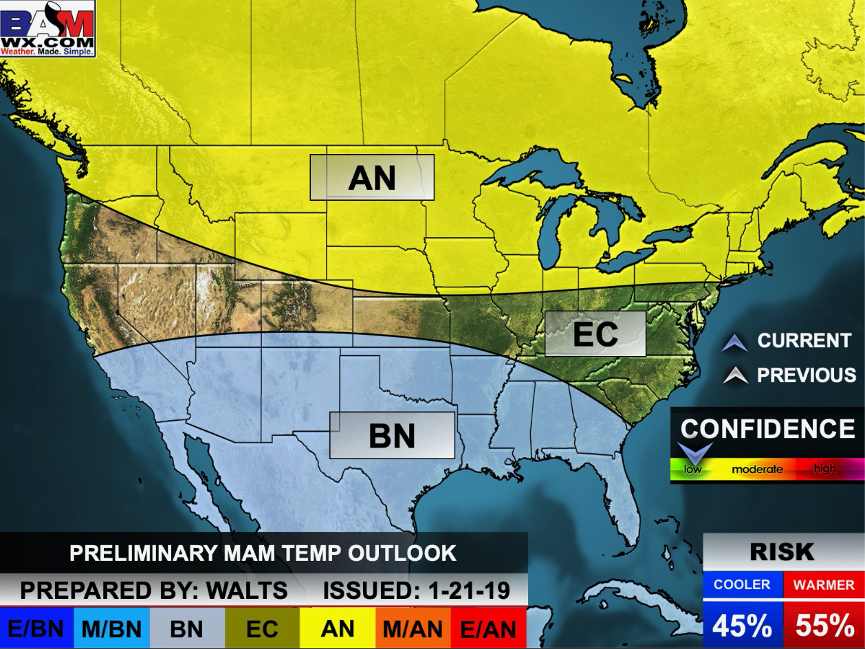
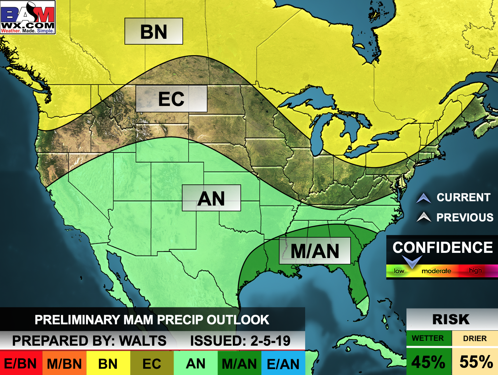
Outlook definitions
EC = Equal chances of above or below normal
BN= Below normal
M/BN = Much below normal
AN = Above normal
M/AN = Much above normal
E/AN = Extremely above normal
Normal high temperatures for this time of the year are around 50 degrees.
Normal low temperatures for this time of the year are around 28 degrees.
Normal precipitation during this time period ranges from 0.90″ to 1.15″
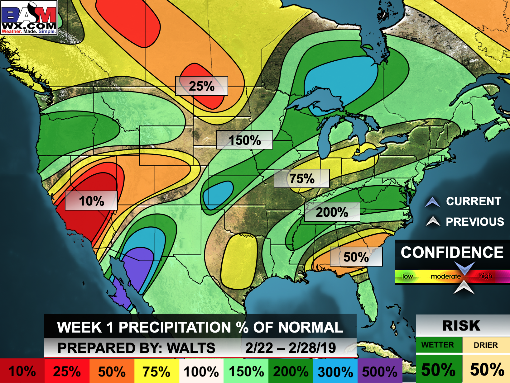
This outlook covers February 20th through February 26th
The precipitation forecast is PERCENT OF NORMAL. For example, if your normal rainfall is 1.00″ and the graphic shows 25%, then that would mean 0.25″ of rain is anticipated.

Normal high temperatures for this time of the year are around 54 degrees
Normal low temperatures for this time of the year are around 32 degrees
Normal precipitation during this time period ranges from 0.90″ to 1.15″
This outlook covers February 27th through February March 5th
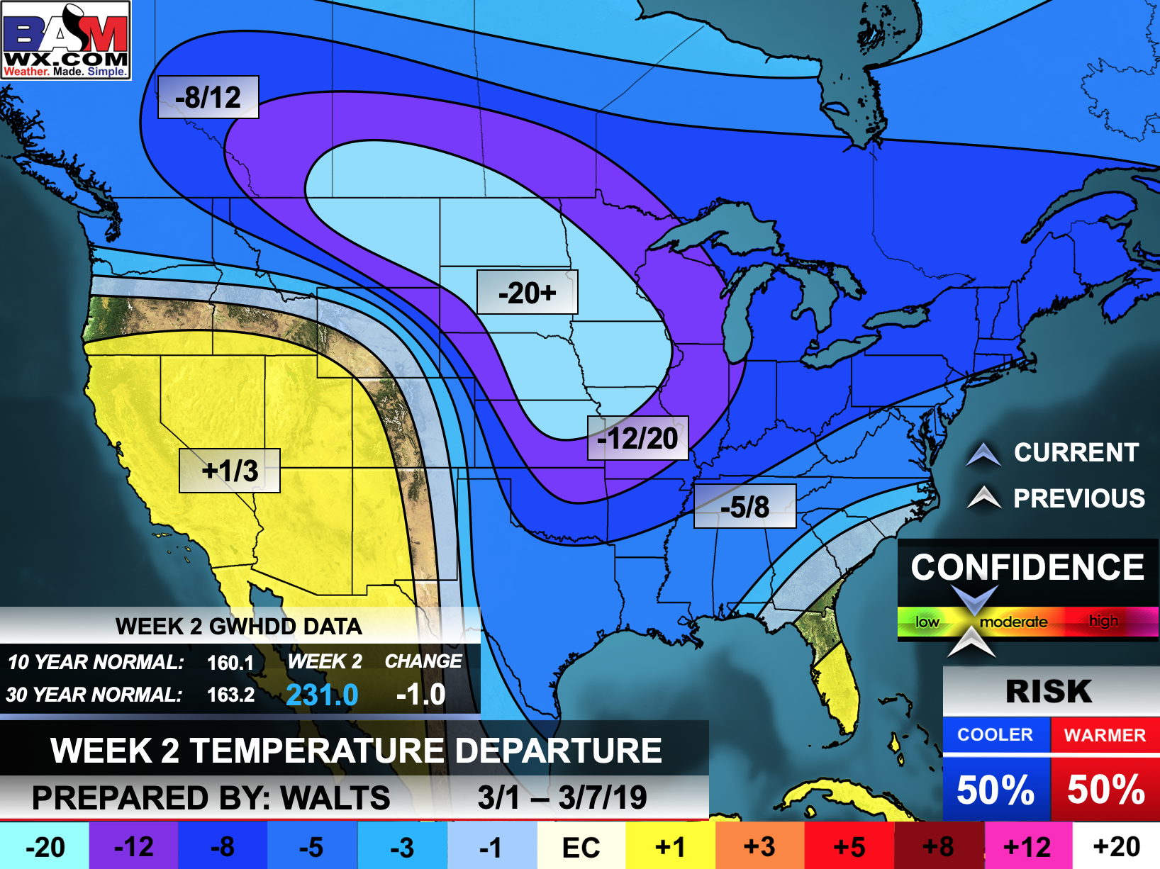
The precipitation forecast is PERCENT OF NORMAL. For example, if your normal rainfall is 1.00″ and the graphic shows 25%, then that would mean 0.25″ of rain is anticipated.

.
Outlook definitions
EC = Equal chances of above or below normal
BN= Below normal
M/BN = Much below normal
AN = Above normal
M/AN = Much above normal
E/AN = Extremely above normal
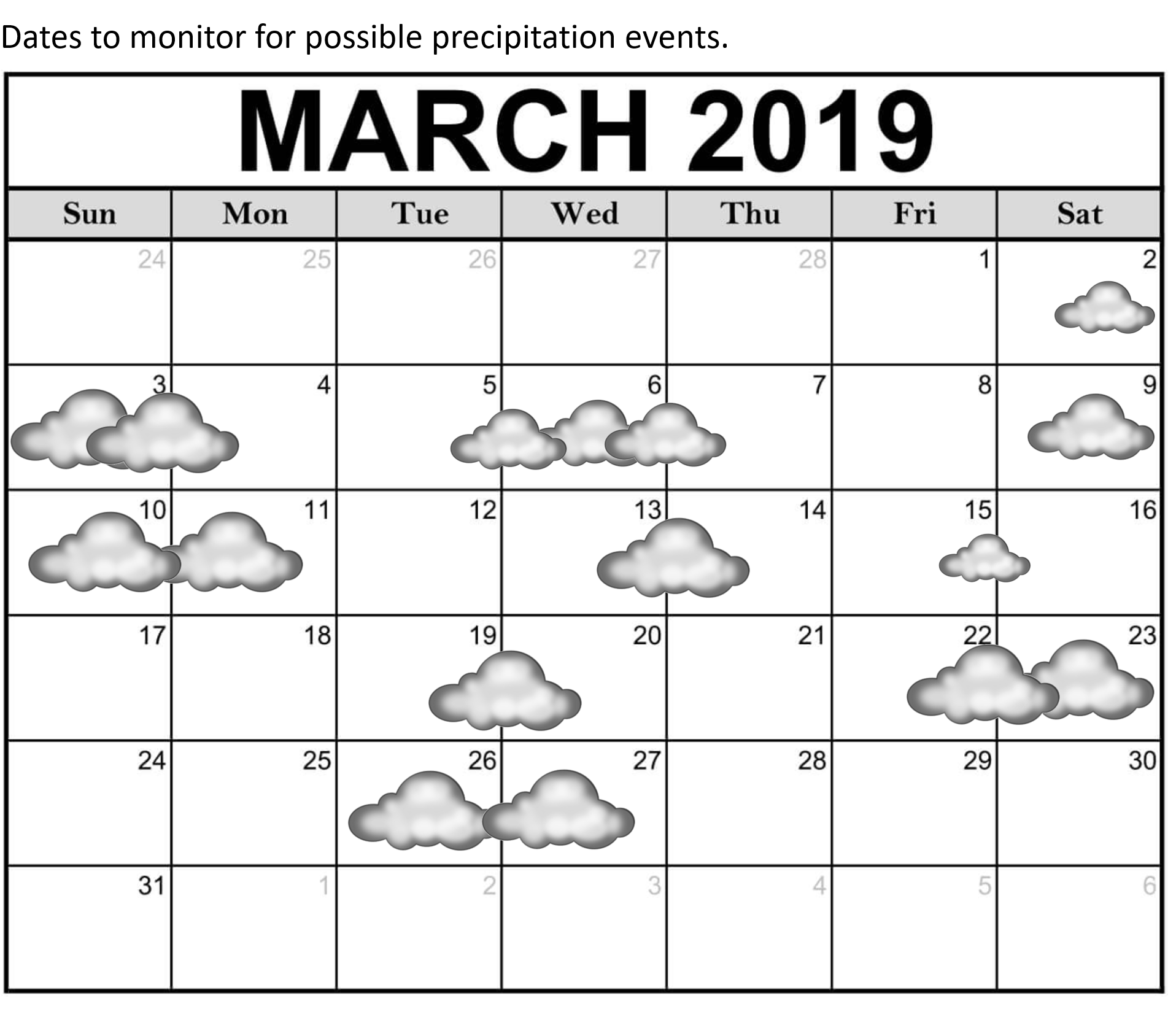
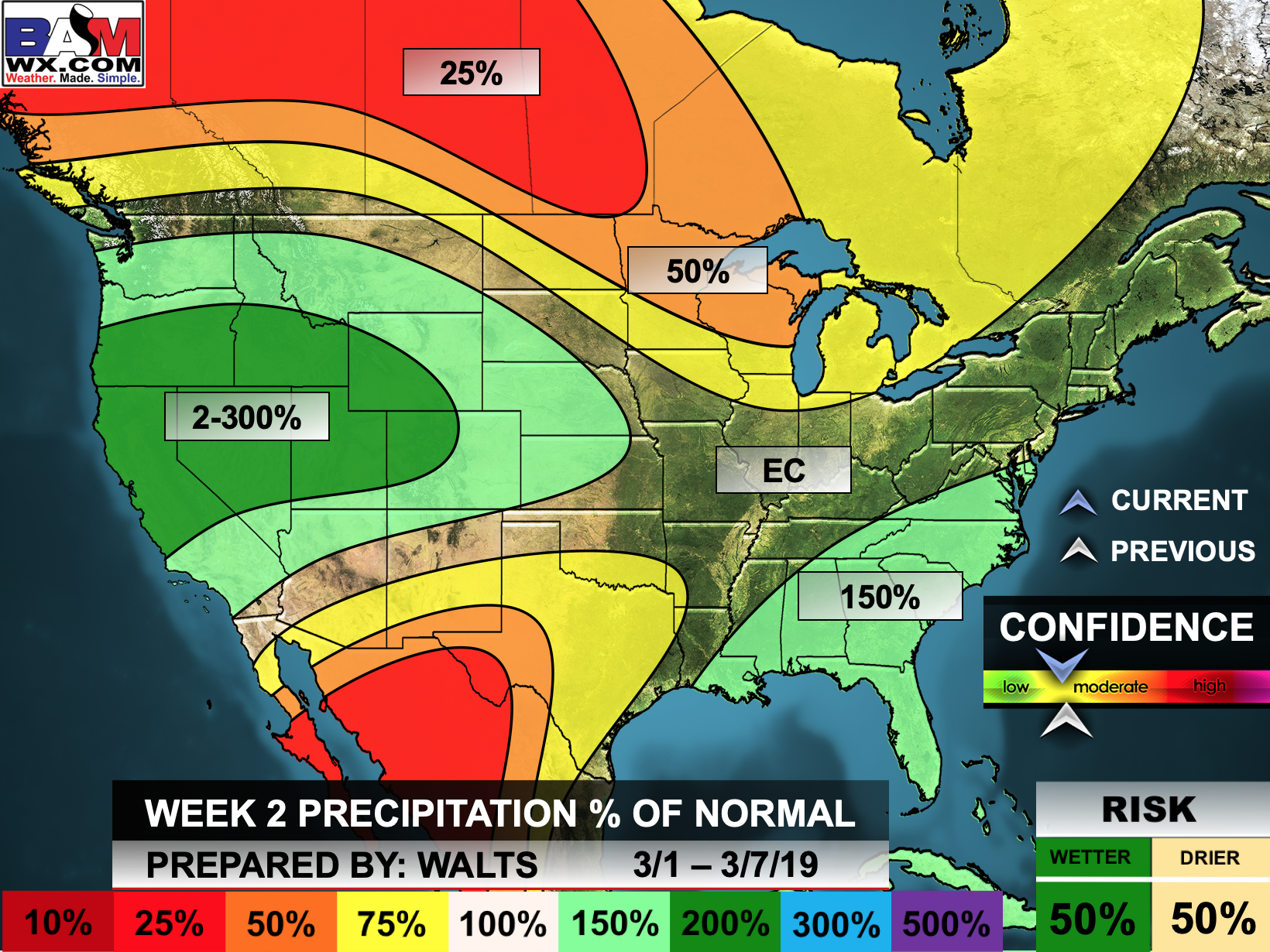
Normal high temperatures for this time of the year are around 54 degrees
Normal low temperatures for this time of the year are around 33 degrees
Normal precipitation during this time period ranges from 1.80″ to 2.10″
This outlook covers March 1st through March 14th
The precipitation forecast is PERCENT OF NORMAL. For example, if your normal rainfall is 1.00″ and the graphic shows 10%, then that would mean 0.10″ of rain is anticipated.
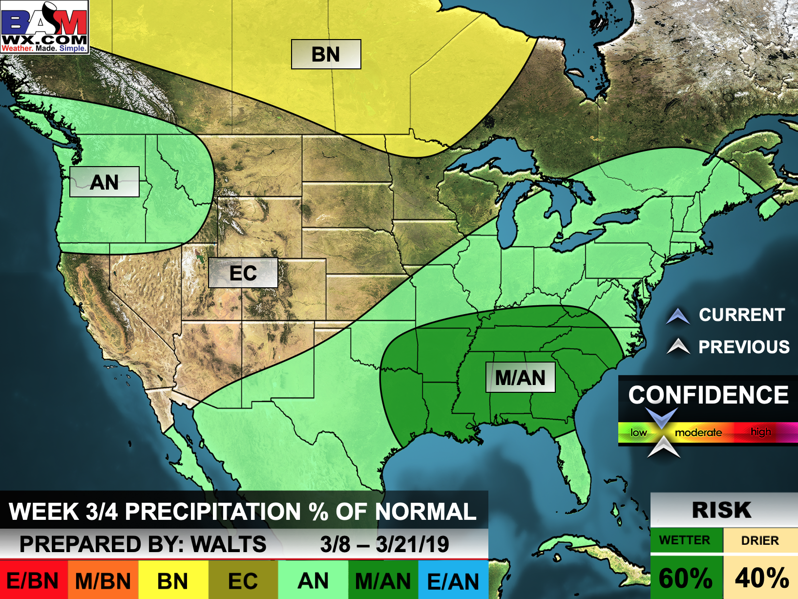

.
Outlook definitions
EC= Equal chances of above or below normal
BN= Below normal
M/BN = Much below normal
AN = Above normal
M/AN = Much above normal
E/AN = Extremely above normal
March temperature and precipitation outlook
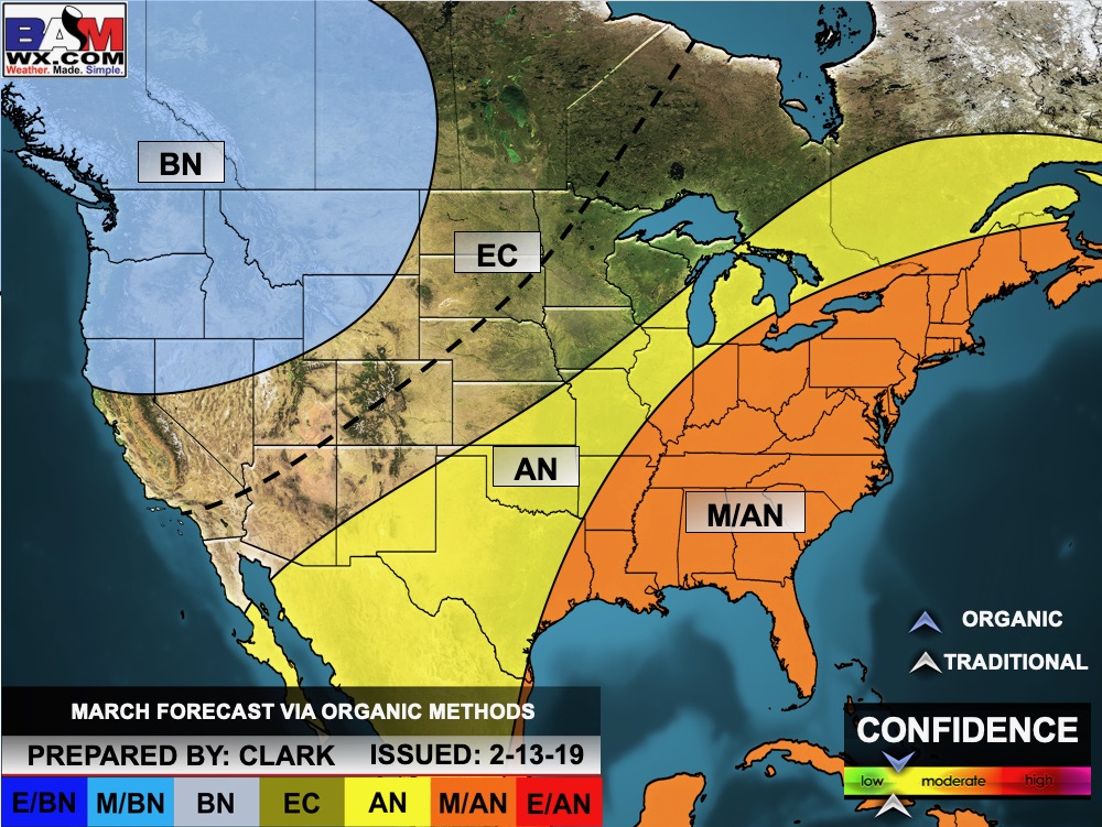
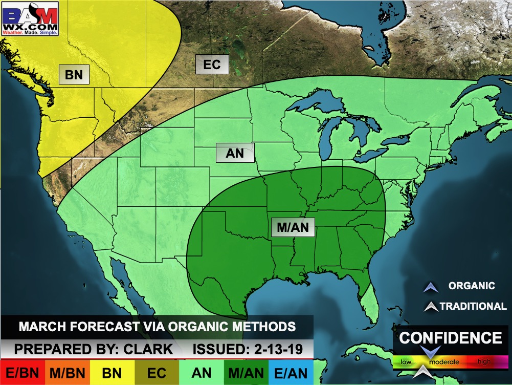
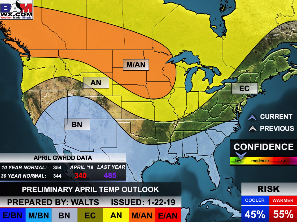
April temperature and precipitation outlook
May temperature and precipitation outlook
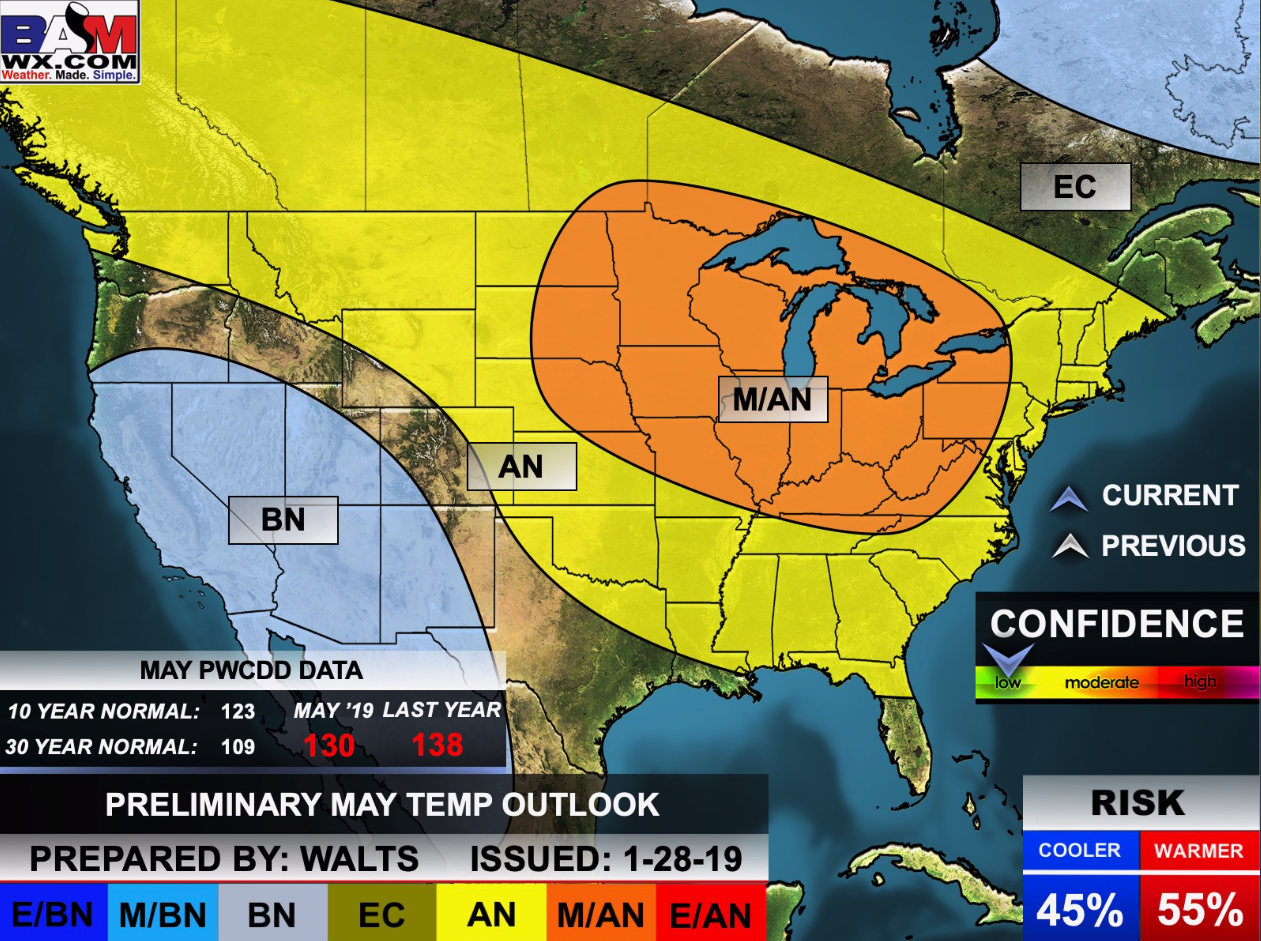
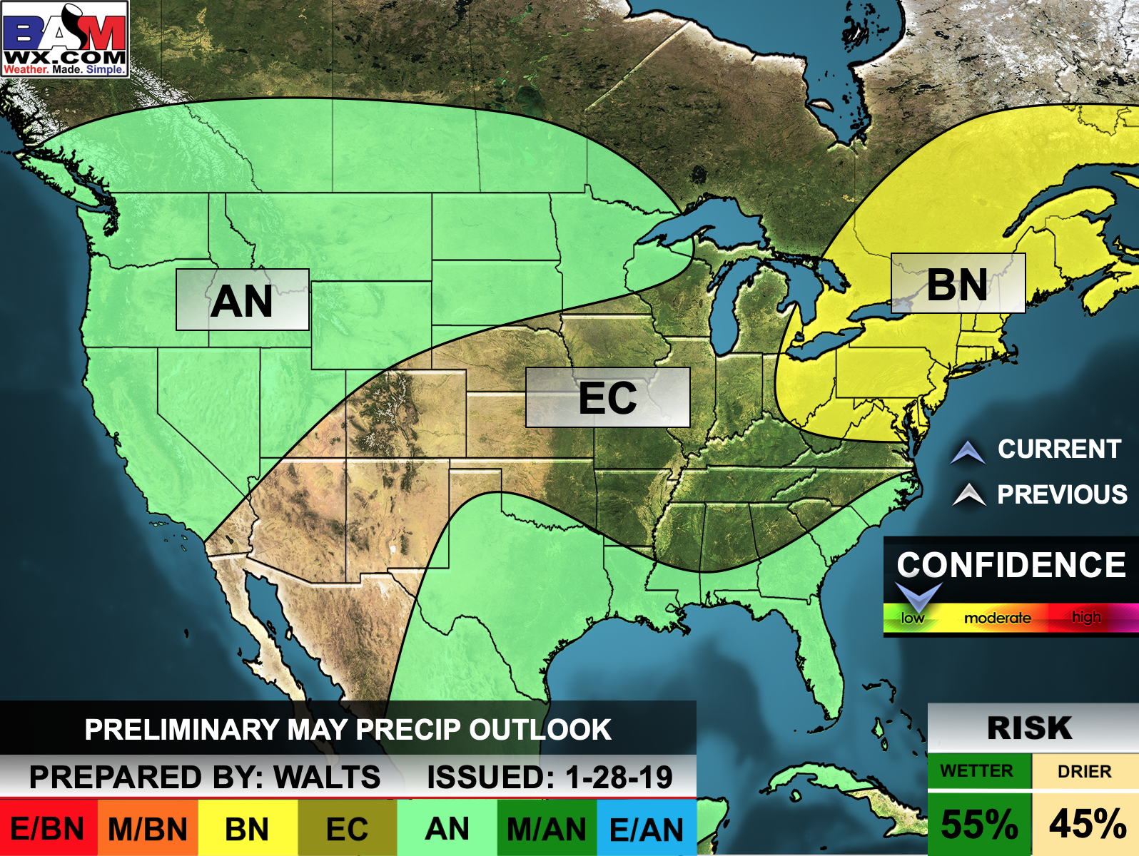
Here is the preliminary March, April, and May temperature and precipitation forecast.
Temperature outlook
Precipitation outlook

 WeatherBrains Episode 683
Tonight’s Guest WeatherBrain is a Professor in the Department of Meteorology & Atmospheric Science At Penn State University. She is also the Director at Penn State’s Institute for CyberScience. Her research areas are on hurricanes, climate change, and using advanced computer models and statistics. She is the current President of the AMS. Dr. Jenni Evans, welcome to WeatherBrains!
Other discussions in this weekly podcast include topics like:
- Tropical Cyclone Tracy (1974)
- Next Generation Global Forecast System
- Future of real time upper air data
- Flash flooding potential across Southeast
- Potential severe weather event on the horizon?
- The Astronomy Report from Tony Rice
- and more!
Link to their website https://weatherbrains.com/
.
Previous episodes can be viewed by clicking here.
Find Beau on Facebook! Click the banner.

.
Find Beau on Twitter! Share your weather photos! @beaudodson

Click here to go to the top of the page
Did you know that a portion of your monthly subscription helps support local charity projects? Not a subscriber? Becoming one at www.weathertalk.com
You can learn more about those projects by visiting the Shadow Angel Foundation website and the Beau Dodson News website.
