
Are you in need of new eye glasses? New contacts? Perhaps you need an eye exam. Then be sure and visit the Eye Care Associates of western Kentucky (the Paducah location). For all of your families eye care needs.
Visit their web-site here. Or, you can also visit their Facebook page.

Best at Enabling Body Shop Profitability since 1996. Located In Paducah Kentucky and Evansville Indiana; serving all customers in between. They provide Customer Service, along with all the tools necessary for body shops to remain educated and competitive. Click the logo above for their main web-site.
You can find McClintock Preferred Finishes on Facebook, as well

Expressway Carwash and Express Lube are a locally owned and operated full-service Carwash and Lube established in 1987.
They have been proudly serving the community for 29 years now at their Park Avenue location and 20 years at their Southside location. They have been lucky enough to partner with Sidecar Deli in 2015, which allows them to provide their customers with not only quality service, but quality food as well.
If you haven’t already, be sure to make Expressway your one-stop shop, with their carwash, lube and deli. For hours of operation and pricing visit www.expresswashlube.com or Expressway Carwash on Facebook.

The quad states area source for Precision Ag Technology. Locally owned and operated, specializing in planting, harvesting, fertilizer application and drainage. Visit them on their website and on Facebook. You can also find them on Twitter. They are located in Almo, Kentucky. Phone 270-718-0245
.———————————————–
The Beau Dodson Weather APP is ready for Apple users (Android is next). The purpose of this APP is for me to deliver your text messages instantly. ATT and Verizon have not always been reliable when it comes to speed. The APP allows instant delivery. You can keep your test messages on and use the APP. You can set the APP to turn off your text messages and just receive them through the APP.
We are working on the Android APP. Hopefully, it will be available in a week or so.
The APP is for subscribers.

The direct download can be viewed here
https://itunes.apple.com/us/app/id1190136514
If you have not signed up for the texting service then you may do so at www.beaudodsonweather.com
If you have not signed up for the texts messages, then please do. Your support helps with all of this

and


This forecast update covers far southern Illinois, far southeast Missouri, and far western Kentucky. See the coverage map on the right side of the blog
Tuesday Night Forecast Details:
Forecast: Some clouds. Isolated showers. Drizzle possible. Dense fog possible.
What impacts are anticipated from the weather? Wet roadways possible. Low visibilities in areas with fog.
Is severe weather expected? No
The NWS defines severe weather as 58 mph winds or great, 1″ hail or larger, and/or tornadoes
What is the chance of precipitation? MO ~ 30% IL ~ 30% KY ~ 30% TN ~ 30%
Coverage of precipitation: Isolated
Should I cancel my outdoor plans? No, but check radars.
My confidence in the forecast verifying: High. This forecast should verify.
Temperatures: MO ~ 52 to 56 IL ~52 to 56 KY ~ 52 to 56 TN ~52 to 56
Winds: Variable winds at 5 to 10 mph
Wind Chill when applicable:
Will there be a chance for wintry precipitation? No
Moonrise will be at 2:53 a.m. and moonset will be at 1:12 p.m. Waning Crescent
.
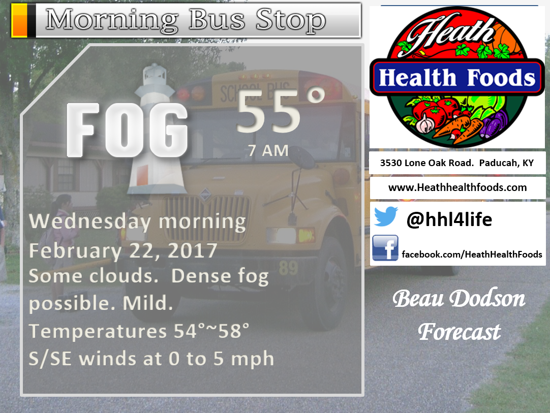
February 22, 2017
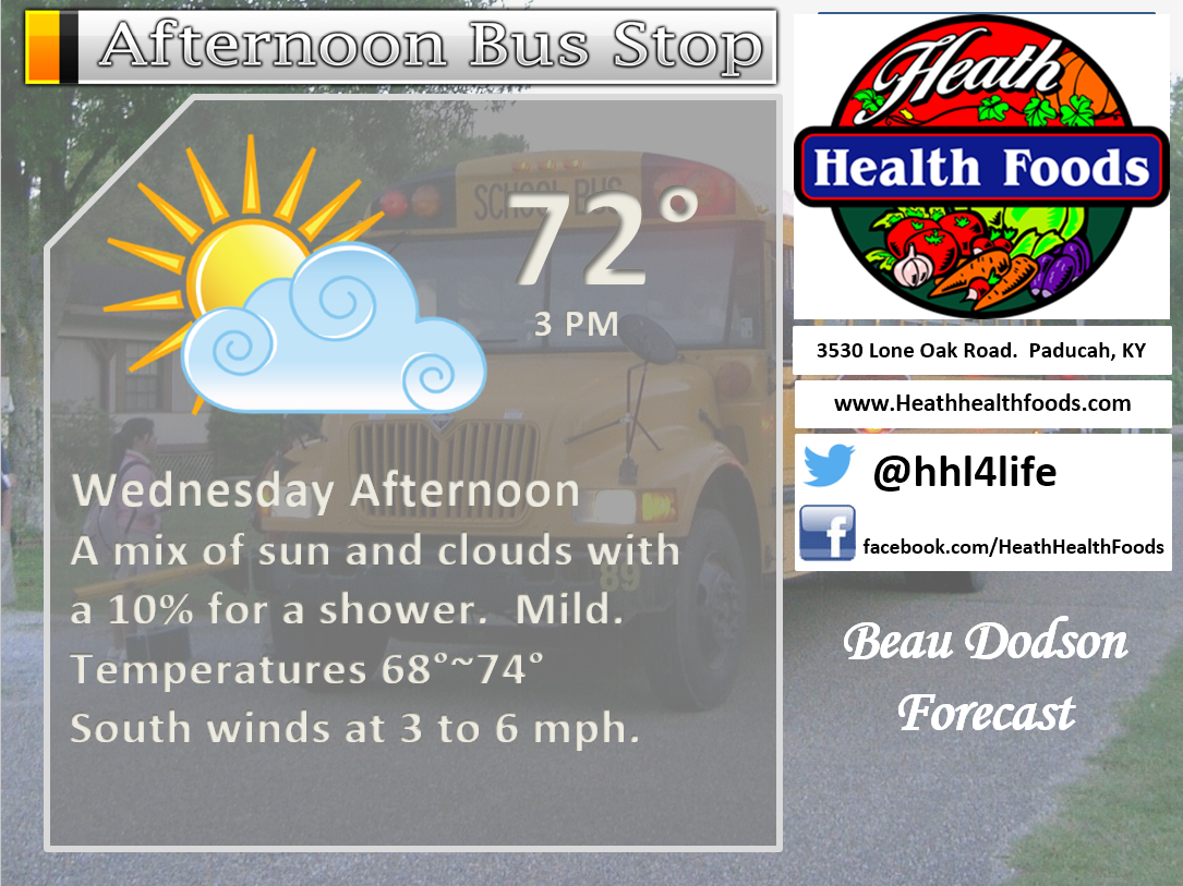
Wednesday Forecast Details
Forecast: Morning dense fog possible. Partly sunny. Mild. An isolated shower possible. Well above normal temperatures.
What impacts are anticipated from the weather? Low visibilities in fog during the morning hours. Isolated wet roadways.
Is severe weather expected? No
The NWS defines severe weather as 58 mph winds or great, 1″ hail or larger, and/or tornadoes
What is the chance of precipitation? MO ~ 20% IL ~ 20% KY ~ 20% TN ~ 20%
Coverage of precipitation: None to isolated.
Should I cancel my outdoor plans? No, but monitor dense fog during the first half of the day.
My confidence in the forecast verifying: High. This forecast should verify.
Temperatures: MO ~ 68 to 75 IL ~ 68 to 75 KY ~ 68 to 75 TN ~ 68 to 75
Winds: South 4 to 8 mph
Wind Chill when applicable:
Will there be a chance for wintry precipitation? No
Sunrise will be at 6:33 a.m. and sunset will be at 5:42 p.m.
UV Index: 1 to 3
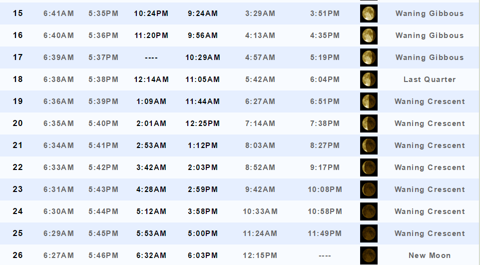
Moonrise will be at 3:42 a.m. and moonset will be at 2:03 p.m. Waning Crescent
Wednesday Night Forecast Details:
Forecast: Cloudy. An isolated shower possible.
What impacts are anticipated from the weather? Most likely none. Spotty wet roadways possible.
Is severe weather expected? No
The NWS defines severe weather as 58 mph winds or great, 1″ hail or larger, and/or tornadoes
What is the chance of precipitation? MO ~ 20% IL ~ 20% KY ~ 20% TN ~ 20%
Coverage of precipitation: Isolated
Should I cancel my outdoor plans? No
My confidence in the forecast verifying: High. This forecast should verify.
Temperatures: MO ~ 55 to 60 IL ~55 to 60 KY ~ 55 to 60 TN ~ 55 to 60
Winds: South and southwest at 5 to 10 mph
Wind Chill when applicable:
Will there be a chance for wintry precipitation? No
Moonrise will be at 3:42 a.m. and moonset will be at 2:03 p.m. Waning Crescent
.
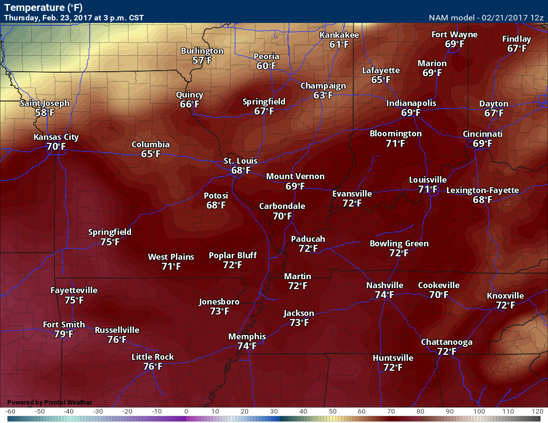
February 23, 2017
Thursday Forecast Details
Forecast: Quite a few clouds. Patchy sun. Mild. Well above normal temperatures. An isolated shower possible.
What impacts are anticipated from the weather? Most likely none. Isolated wet roadways.
Is severe weather expected? No
The NWS defines severe weather as 58 mph winds or great, 1″ hail or larger, and/or tornadoes
What is the chance of precipitation? MO ~ 10% IL ~ 10% KY ~ 10% TN ~ 10%
Coverage of precipitation: None to isolated.
Should I cancel my outdoor plans? No.
My confidence in the forecast verifying: High. This forecast should verify.
Temperatures: MO ~ 74 to 78 IL ~ 72 to 76 KY ~ 74 to 76 TN ~ 74 to 78
Winds: South and southwest 10 to 20 mph with gusts to 25 mph
Wind Chill when applicable:
Will there be a chance for wintry precipitation? No
Sunrise will be at 6:31 a.m. and sunset will be at 5:43 p.m.
UV Index: 1 to 3
Moonrise will be at 4:28 a.m. and moonset will be at 2:59 p.m. Waning Crescent
Thursday Night Forecast Details:
Forecast: Cloudy. A 20% chance for a shower. Mild.
What impacts are anticipated from the weather? Perhaps a few wet roadways. Small risk for lightning.
Is severe weather expected? No.
The NWS defines severe weather as 58 mph winds or great, 1″ hail or larger, and/or tornadoes
What is the chance of precipitation? MO ~ 20% IL ~ 20% KY ~ 20% TN ~ 20%
Coverage of precipitation: Isolated
Should I cancel my outdoor plans? No
My confidence in the forecast verifying: High. This forecast should verify.
Temperatures: MO ~ 56 to 64 IL ~56 to 64 KY ~ 56 to 64 TN ~ 56 to 64
Winds: South and southwest at 10 to 20 mph with gusts above 30 mph possible.
Wind Chill when applicable:
Will there be a chance for wintry precipitation? No
Moonrise will be at 4:28 a.m. and moonset will be at 2:59 p.m. Waning Crescent
.
February 24, 2017
Friday Forecast Details
Forecast: A mix of sun and clouds. Breezy. Very warm, for February. Scattered showers and thunderstorms possible (mainly after 1 pm). Temperatures will fall behind the cold front into the 50’s (mainly over southeast MO and southern IL). Timing of the front will need to be monitored and would impact temperatures late in the day.
What impacts are anticipated from the weather? Wet roadways. Lightning. A few strong storms possible.
Is severe weather expected? I can’t rule out some strong storms. This would mainly be over southeast Illinois and portions of western Kentucky. Monitor updates.
The NWS defines severe weather as 58 mph winds or great, 1″ hail or larger, and/or tornadoes
What is the chance of precipitation? MO ~ 30% IL ~ 50% KY ~ 50% TN ~ 40%
Coverage of precipitation: Scattered, mainly during the afternoon
Should I cancel my outdoor plans? No, but monitor updates moving forward
My confidence in the forecast verifying: Medium. Some adjustments are possible
Temperatures: MO ~ 70 to 75 with falling temperatures as a cold front sweeps eastward IL ~ 70 to 75 with falling temperatures as a cold front sweeps eastward KY ~ 72 to 76 with falling temperatures as a cold front sweeps eastward TN ~72 to 76 with falling temperatures as a cold front sweeps eastward
Winds: South and southwest 10 to 25 mph with higher gusts likely. Winds becoming west and northwest through the day as a cold front passes across the region.
Wind Chill when applicable:
Will there be a chance for wintry precipitation? No
Sunrise will be at 6:30 a.m. and sunset will be at 5:44 p.m.
UV Index: 3 to 5
Moonrise will be at 5:12 a.m. and moonset will be at 3:58 p.m. Waning Crescent
Friday Night Forecast Details:
Forecast: Cloudy. Evening showers and thunderstorms possible. Best chances over the eastern half of the region. Becoming partly cloudy late. Breezy, at times.
What impacts are anticipated from the weather? Wet roadways. Lightning. Will need to monitor whether severe weather is a concern for our eastern counties of the region.
Is severe weather expected? Monitor updates.
The NWS defines severe weather as 58 mph winds or great, 1″ hail or larger, and/or tornadoes
What is the chance of precipitation? MO ~ 30% IL ~ 50% KY ~ 50% TN ~ 40%
Coverage of precipitation: Scattered and ending from west to east.
Should I cancel my outdoor plans? Monitor updates
My confidence in the forecast verifying: Medium
Temperatures: MO ~ 36 to 42 IL ~36 to 42 KY ~ 36 to 42 TN ~ 36 to 42
Winds: Becoming north and northwest at 8 to 16 mph with gusts above 20 mph
Wind Chill when applicable: 28 to 36
Will there be a chance for wintry precipitation? No
Moonrise will be at 5:12 a.m. and moonset will be at 3:58 p.m. Waning Crescent
.
February 25, 2017
Saturday Forecast Details
Forecast: Partly to mostly sunny and cooler.
What impacts are anticipated from the weather? None.
Is severe weather expected? No
The NWS defines severe weather as 58 mph winds or great, 1″ hail or larger, and/or tornadoes
What is the chance of precipitation? MO ~ 0% IL ~ 0% KY ~ 0% TN ~ 0%
Coverage of precipitation: None
Should I cancel my outdoor plans? No, but it will be chilly.
My confidence in the forecast verifying: High. This forecast should verify.
Temperatures: MO ~ 44 to 48 IL ~ 44 to 48 KY ~ 44 to 48 TN ~ 44 to 48
Winds: West and northwest at 6 to 12 mph with gusts above 20 mph
Wind Chill when applicable: 30 to 40
Will there be a chance for wintry precipitation? No
Sunrise will be at 6:29 a.m. and sunset will be at 5:45 p.m.
UV Index: 2 to 4
Moonrise will be at 5:53 a.m. and moonset will be at 5:00 p.m. Waning Crescent
Saturday Night Forecast Details:
Forecast: Mostly clear. Patchy fog possible.
What impacts are anticipated from the weather? Perhaps some lower visibility if fog forms.
Is severe weather expected? No
The NWS defines severe weather as 58 mph winds or great, 1″ hail or larger, and/or tornadoes
What is the chance of precipitation? MO ~ 0% IL ~ 0% KY ~ 0% TN ~ 0%
Coverage of precipitation: None.
Should I cancel my outdoor plans? No
My confidence in the forecast verifying: High. This forecast should verify.
Temperatures: MO ~ 26 to 32 IL ~26 t0 32 KY ~ 26 to 34 TN ~ 26 to 32
Winds: West and northwest at 0 to 5 mph
Wind Chill when applicable: 25 to 30
Will there be a chance for wintry precipitation? No
Moonrise will be at 5:53 a.m. and moonset will be at 5:00 p.m. Waning Crescent
.
February 26, 2017
Sunday Forecast Details
Forecast: Sunshine during the morning hours. Increasing clouds during the afternoon.
What impacts are anticipated from the weather? None
Is severe weather expected? No
The NWS defines severe weather as 58 mph winds or great, 1″ hail or larger, and/or tornadoes
What is the chance of precipitation? MO ~ 20% IL ~ 10% KY ~ 10% TN ~ 20%
Coverage of precipitation: Most likely none
Should I cancel my outdoor plans? No
My confidence in the forecast verifying: Low. Significant adjustments are possible.
Temperatures: MO ~ 46 to 54 IL ~ 46 to 54 KY ~ 46 to 54 TN ~ 46 to 54
Winds: Becoming south and southwest at 4 to 8 mph
Wind Chill when applicable:
Will there be a chance for wintry precipitation? No
Sunrise will be at 6:27 a.m. and sunset will be at 5:48 p.m.
UV Index: 1 to 3
Moonrise will be at 6:32 a.m. and moonset will be at 6:03 p.m. New Moon
Sunday Night Forecast Details:
Forecast: Cloudy. Showers possible. Chilly.
What impacts are anticipated from the weather? Wet roadways.
Is severe weather expected? No
The NWS defines severe weather as 58 mph winds or great, 1″ hail or larger, and/or tornadoes
What is the chance of precipitation? MO ~ 40% IL ~ 40% KY ~ 40% TN ~ 40%
Coverage of precipitation: Scattered, but monitor because confidence is lower than normal.
Should I cancel my outdoor plans? Monitor radars, but don’t cancel plans.
My confidence in the forecast verifying: Low. Significant adjustments are possible.
Temperatures: MO ~ 34 to 40 IL ~ 34 to 40 KY ~ 34 to 40 TN ~ 34 to 40
Winds: South 5 to 10 mph
Wind Chill when applicable:
Will there be a chance for wintry precipitation? No
Moonrise will be at 6:32 a.m. and moonset will be at 6:03 p.m. New Moon
More information on the UV index. Click here
The School Bus Stop Forecast is sponsored by Heath Health and Wellness.
Located next to Crowell Pools in Lone Oak, Kentucky.
Visit their website here. Visit Heath Health Foods on Facebook!

Heath Health Foods is a locally owned and operated retail health and wellness store. Since opening in February 2006; the store has continued to grow as a ministry with an expanding inventory which also offers wellness appointments and services along with educational opportunities.
Visit their web-site here. And. visit Heath Health Foods on Facebook!.

Don’t forget to check out the Southern Illinois Weather Observatory web-site for weather maps, tower cams, scanner feeds, radars, and much more! Click here

An explanation of what is happening in the atmosphere over the coming day
Analysis
Tuesday night
Confidence: Medium
Clouds and spotty light showers will linger into Tuesday evening. Clouds overnight. There is a chance for some clearing late tonight. Patchy fog is also possible.
Temperatures will remain well above normal tonight, mostly in the 50’s.
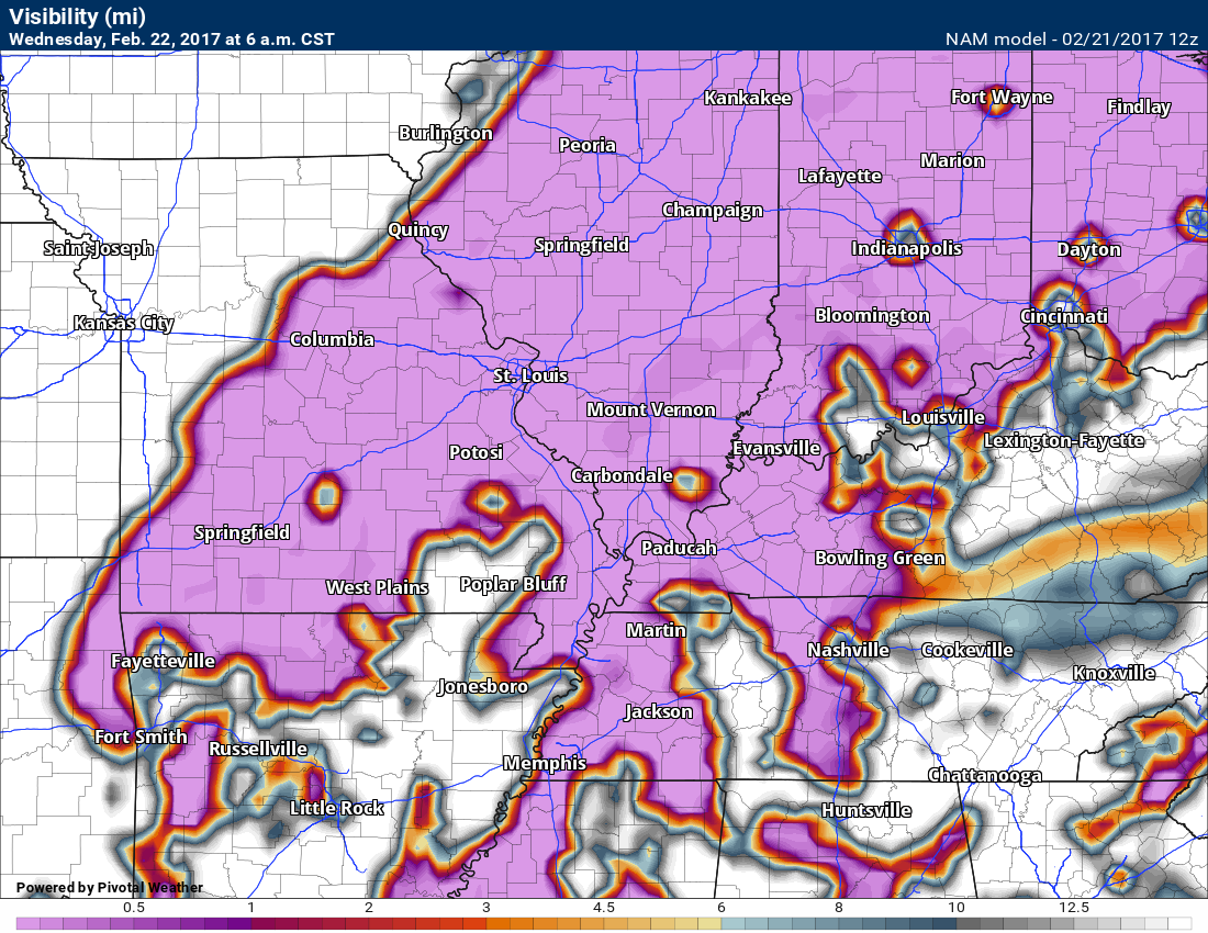
Visibility forecast map for 3 am and 6 am Wednesday. The pink area indicates lower visibilities. Fog? Perhaps. Drizzle possible, as well.
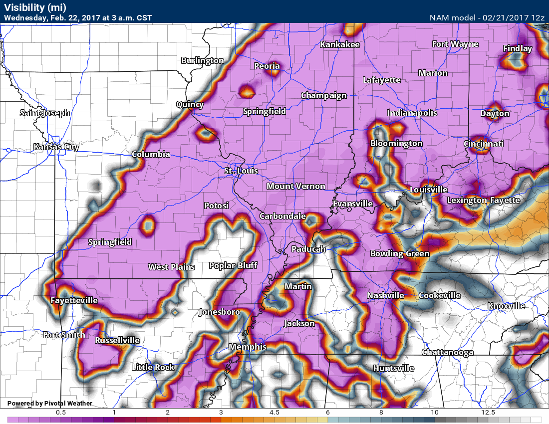
and 6 am
Wednesday through Thursday
Confidence: Medium
A mix of sun and clouds on Wednesday. Warm. Temperatures will continue to feel more like spring than February. Shocker. 🙂
You can expect 70’s on both Wednesday and Thursday. How high into the 70’s will be dependent on cloud cover. Better chance for sun on Wednesday vs Thursday. Either way, warm air.
A few spotty showers are possible Wednesday into Thursday, as well. Perhaps capping chances at around 20%. Most areas will remain dry through that time period.
Thunderstorms are not anticipated Wednesday or Thursday. No severe concerns on either of those days.
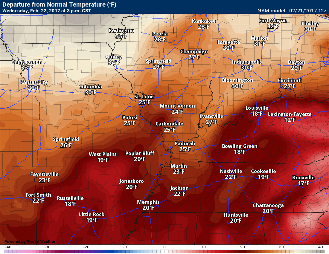
Check out the amazing temperature anomalies for Wednesday and Thursday. How many times have I said that over the past few months.
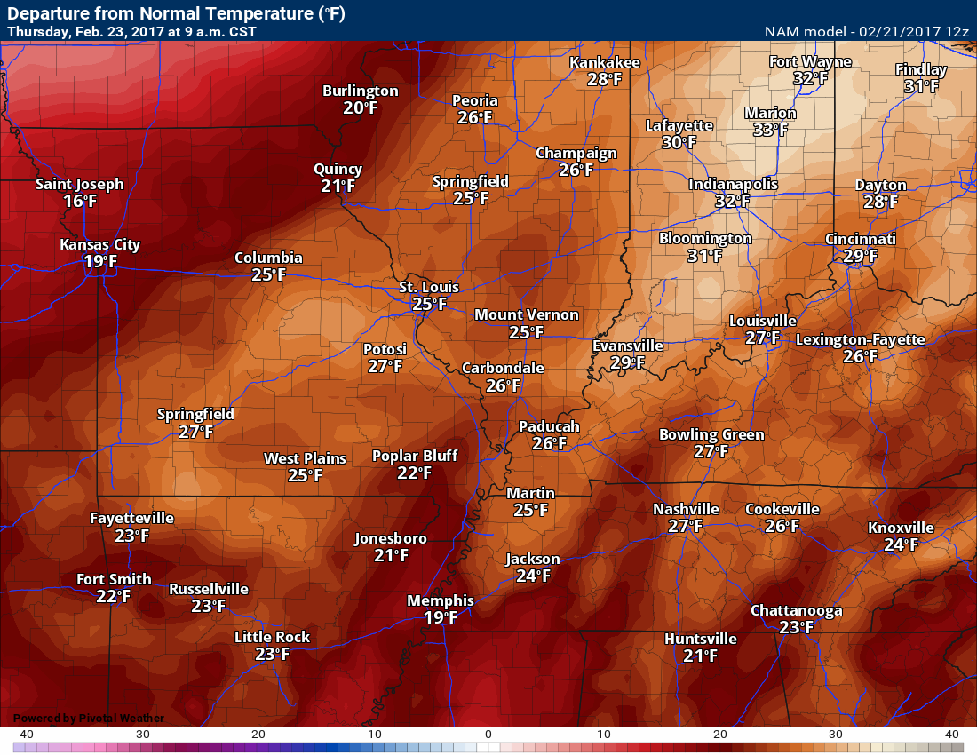
3 pm Wednesday departures. WELL above normal temperatures.
Normal high temperatures are around 50 degrees. Normal low temperatures are around 30 degrees.
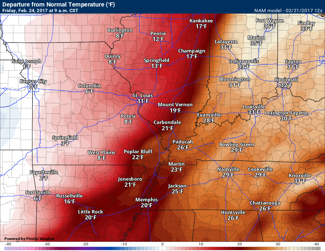
9 AM Thursday anomalies
Thursday night into Friday night
Confidence: Medium
Clouds will be on the increase Thursday night and Friday. This will occur ahead of a strong cold front. The front will sweep across our region on Friday and Friday evening.
Temperatures will fall, during the day on Friday, from west to east.
Moisture will be pulled northward ahead of this system. Warm air, as well.
Here is the 9 am Friday temperature anomaly map. How many degrees above normal? Plenty!
Gusty winds. Winds may top 30 mph on Thursday night/Friday and Friday night. Gradient winds. Gradient winds are caused by tight pressure gradients.
Here is the wind forecast map for Thursday night. Some gusts above 30 mph possible.
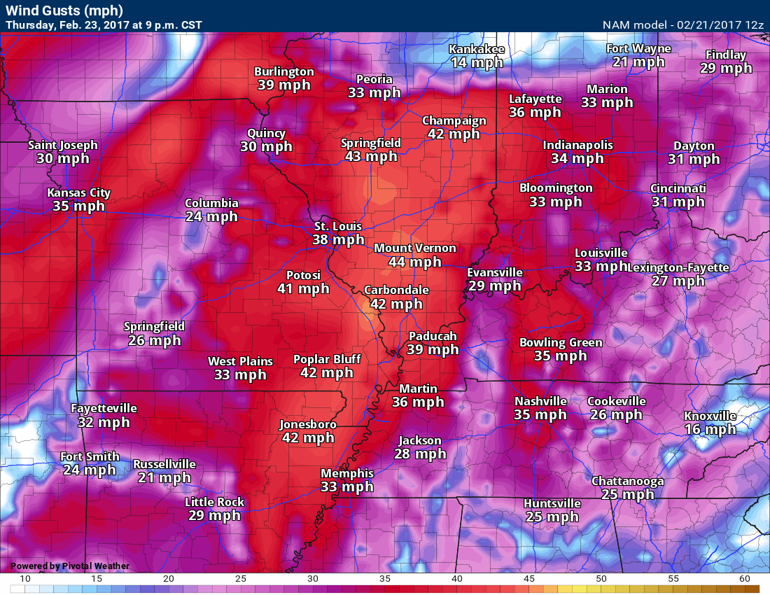
An area of low pressure will pass well to our northwest and north on Friday/Friday night. Thus, gusty winds in our region.
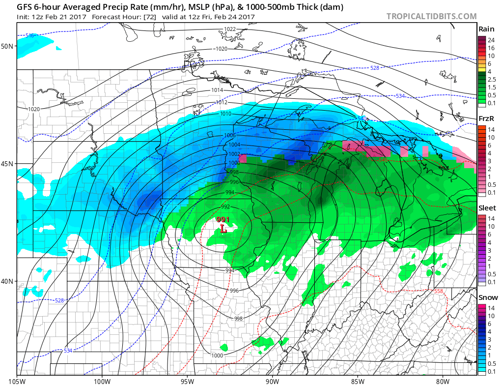
You can see the low on the map below. This is the 6 am Friday weather map. Snow north of the low (blue colors). Notice the isobars are tightly packed together near the low. That means gusty winds.
This next map is for 6 pm on Friday. The low continues to track northeast. A green band into our region represents some scattered showers and thunderstorms. We will need to monitor the thunderstorm activity. Some strong storms are possible in the Ohio Valley. Perhaps the greatest risk will be to our northeast and east. Monitor updates. Still several days away.
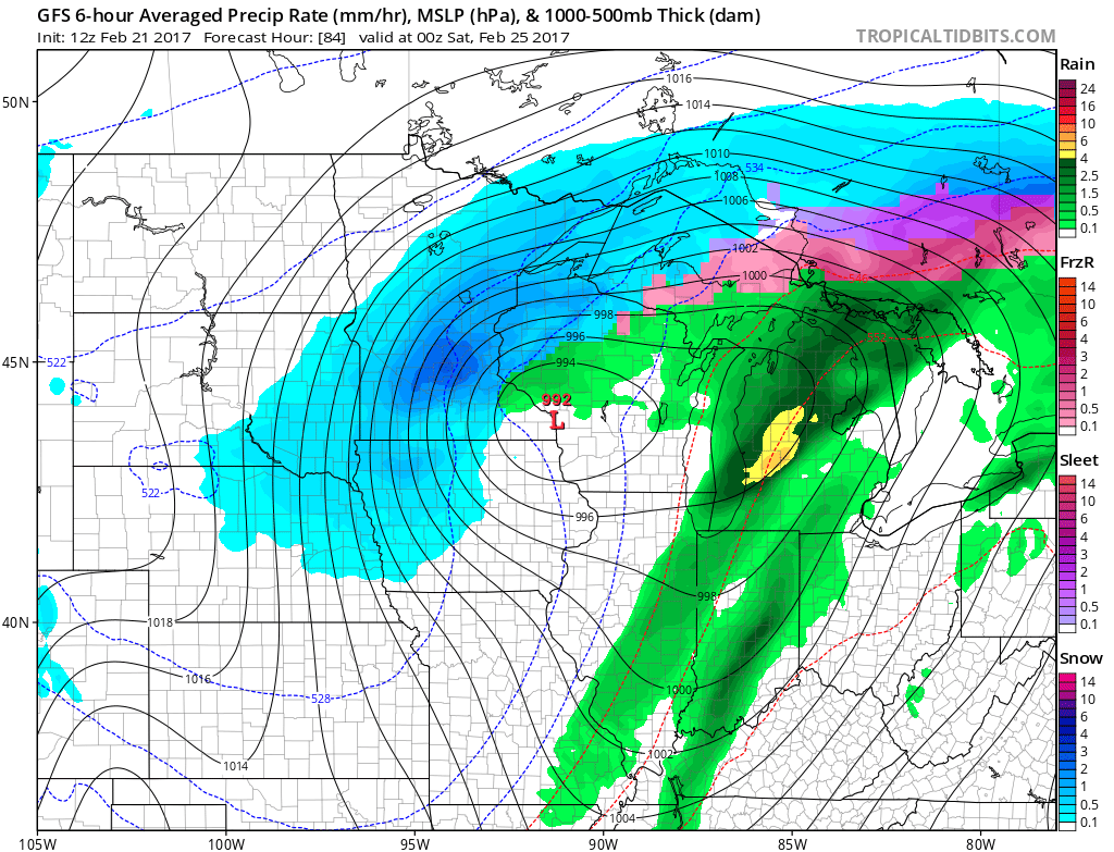
This next map is for 12 am on Saturday. Low to our north. Notice the band of thunderstorms moving to our east. Colder air will filter in behind the cold front. Saturday will be chillier than recent days.

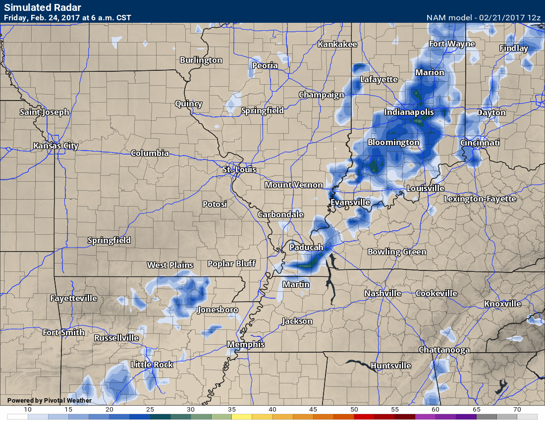
Here is the NAM future-cast radar for Friday. We might see some showers and storms ahead of the front. Quite a bit of debate about just how far west precipitation should be placed.
Let’s plan on 40% chances, for now. I will fine tune the forecast moving forward.
6 am Friday radar. Future-cast radar shows you what radar might look like.
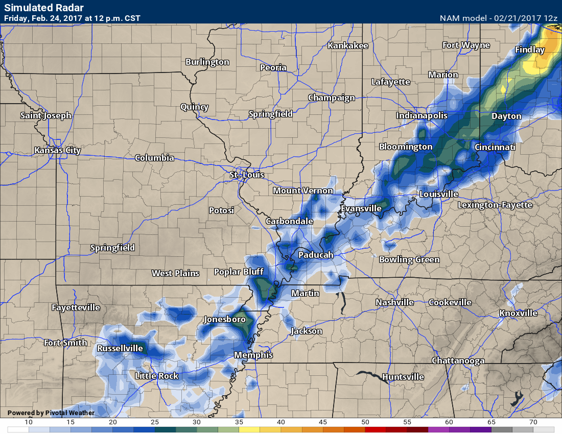
This next map is for 12 pm on Friday
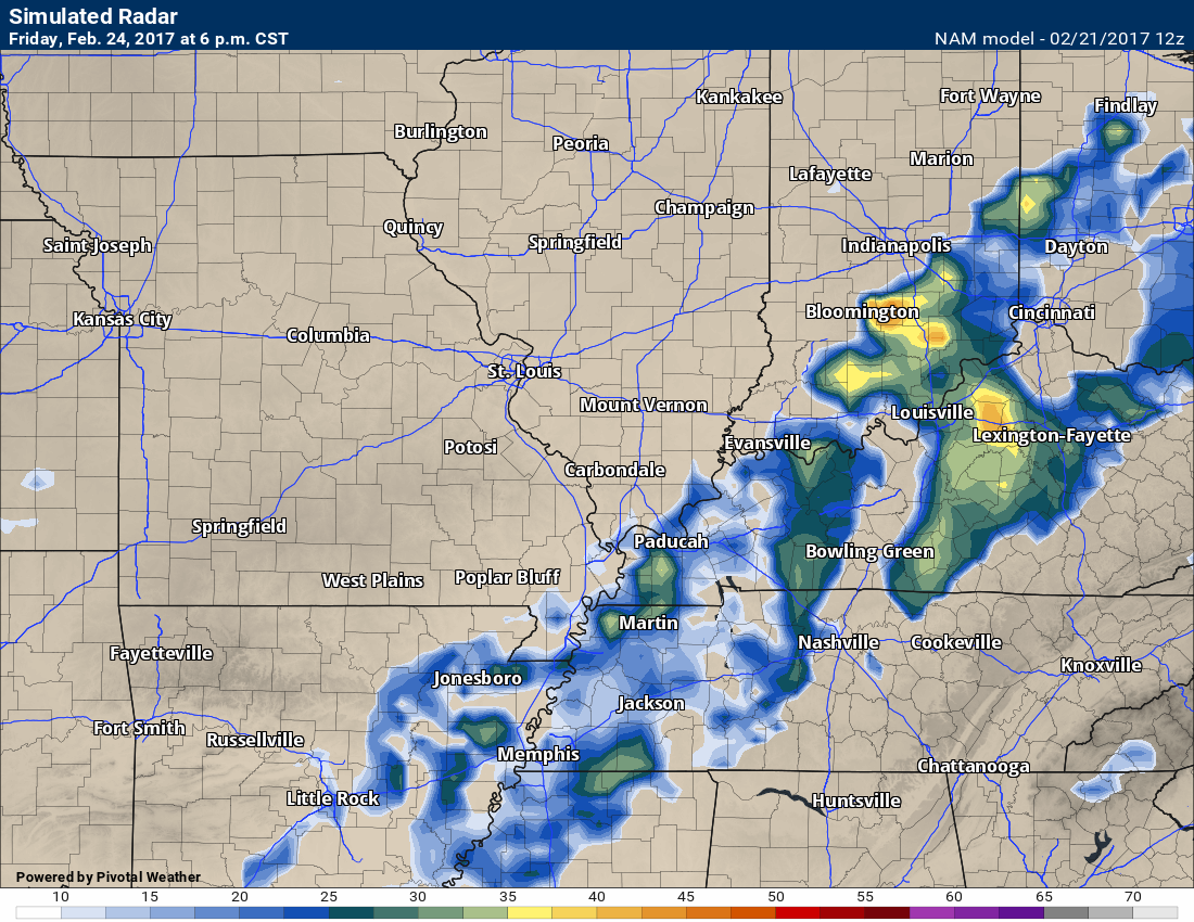
This next map is for 6 pm on Friday
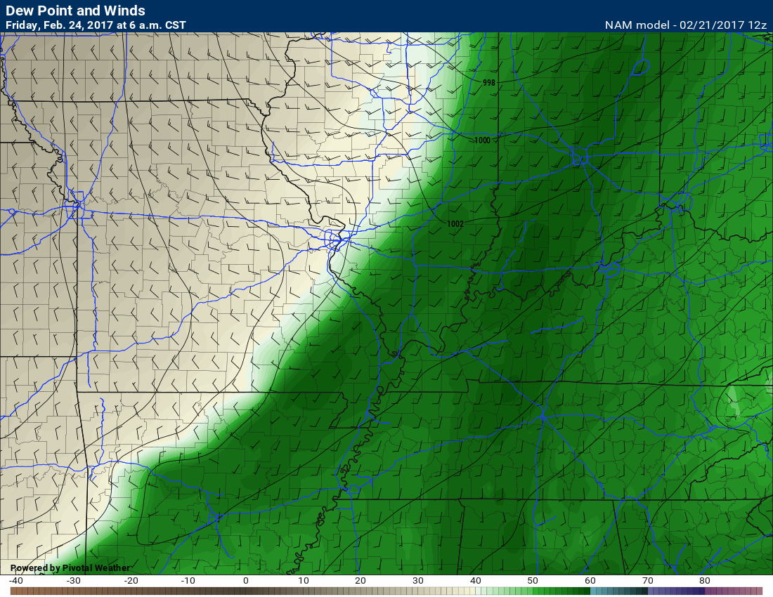
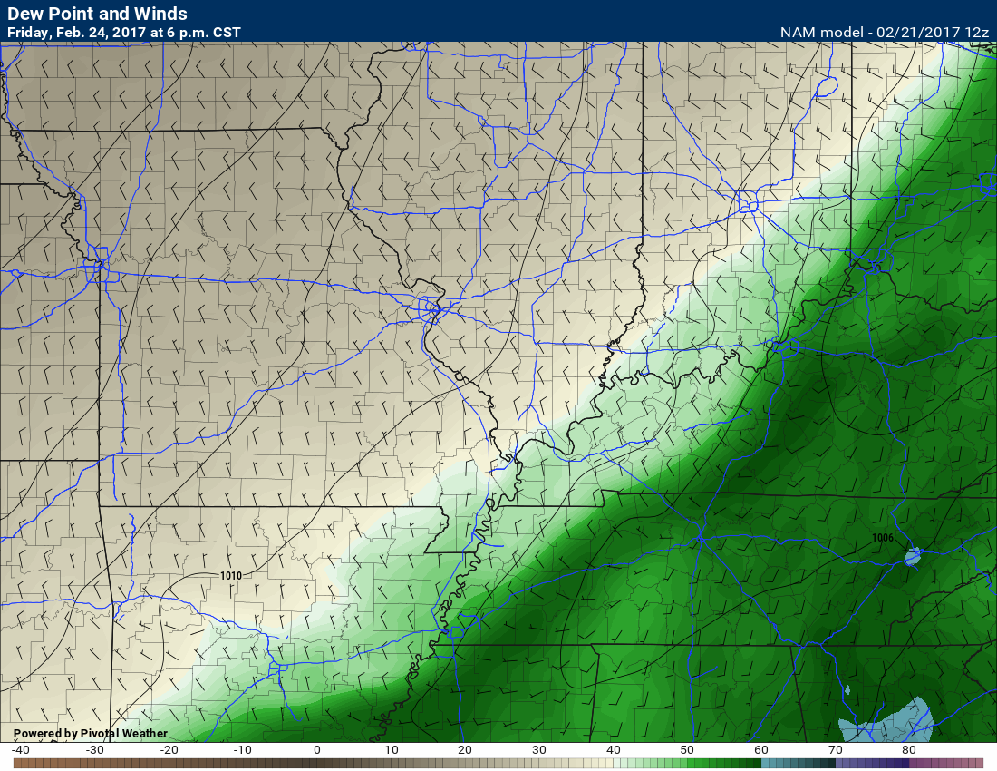
You can track the front via this dew point map on Friday. Notice the sharp drop-off in dew point temperatures. Dew point is a great way to measure moisture in the lower atmosphere (surface)
Dew points drop behind cold fronts. Nice sharp edge on this map.
Here is the 6 am dew point map for Friday
Here is the 6 pm dew point map for Friday. Dew points will quickly fall behind the cold front as moisture is swept eastward.
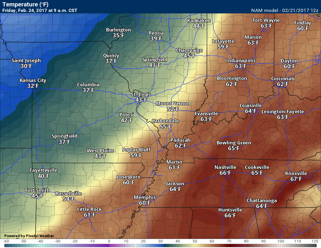
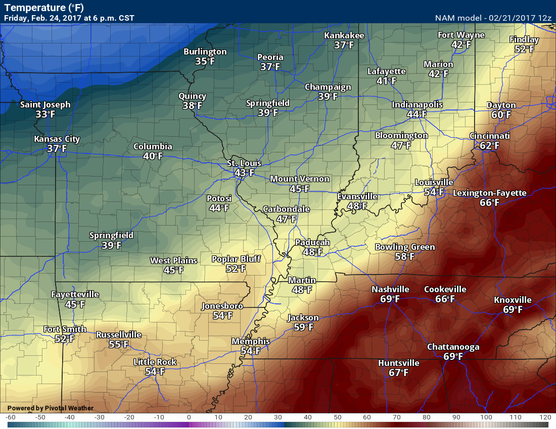
Temperatures will fall through the day on Friday. They will fall as the front moves from west to east.
Here is the 9 am temperature map (Friday)
Compare that to 6 pm on Friday. Falling temps behind the front.
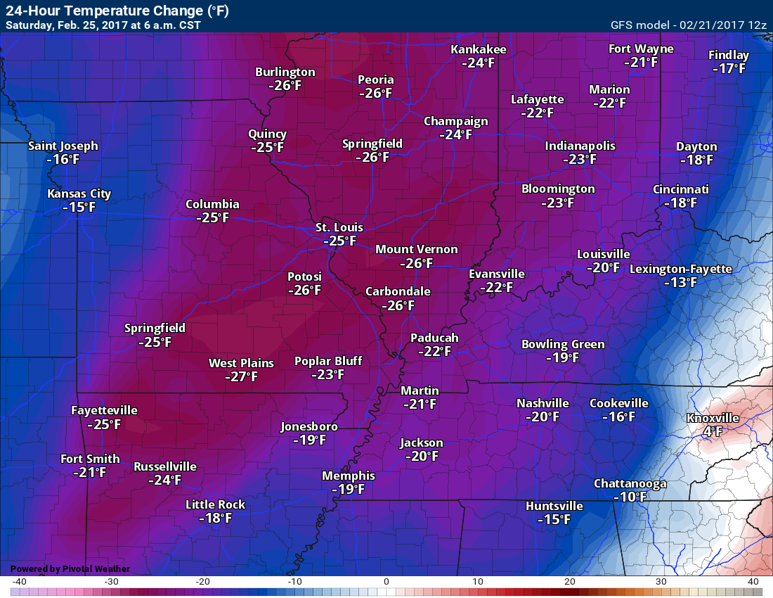
Temperatures will have fallen 20 to 30 degrees between Friday morning and Saturday morning.
Here is the 24 hour temperature change map
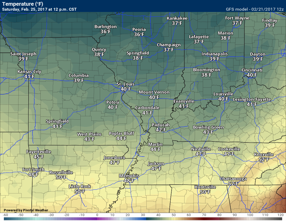
Here is the Saturday 12 pm temperature map
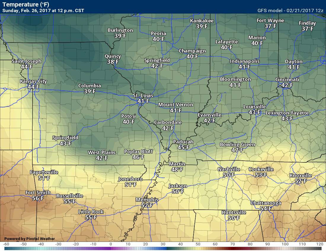
Cool air on Sunday, as well.
Sunday 12 pm temperature map
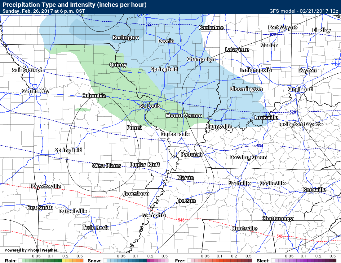
A weak system is forecast to pass through the area Sunday afternoon into Monday. Some debate about the eventual track of the area of low pressure. Colder air to the north of the low. Snow showers will be possible near our region. Perhaps just a little to the north and northeast. I will keep an eye on trends.
Either way, chilly air for our region with some chance for showers on Sunday afternoon and night.
Next week looks unsettled with a few chances for showers and perhaps thunderstorms.

Find me on Twitter

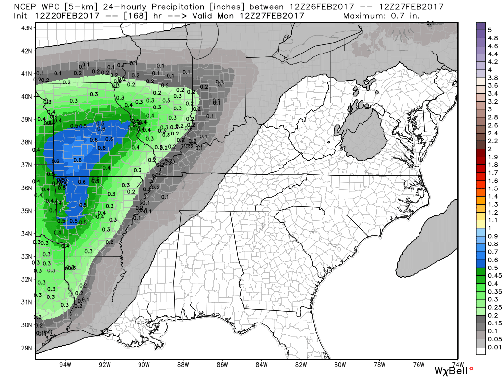
How much rain is expected over the coming days?
Another chance for rain arrives Thursday night/Friday and Friday night. Still some questions remain on placement of precipitation for that particular event.
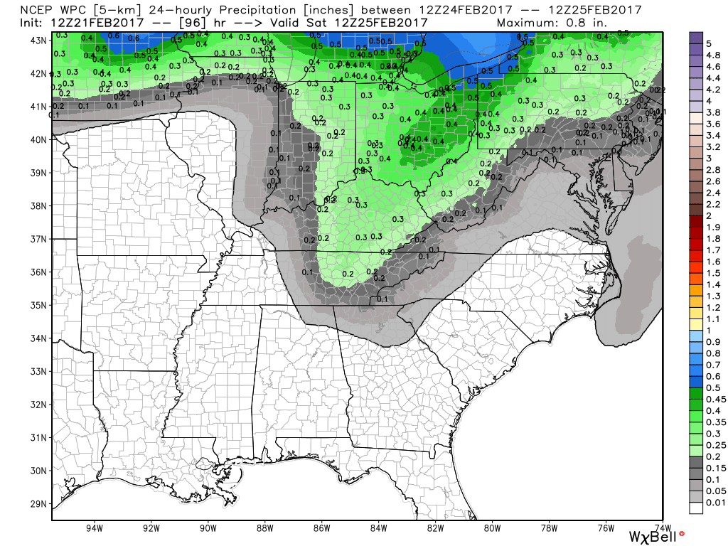
Here is the official NOAA rainfall predictions
This graphic (below) is for the Thursday night into Friday night event. Notice how far east NOAA is with the rainfall totals. This will need to be monitored. Not all data agrees. Some of the data has rain further west, as well. Low confidence.
Keep in mind, a thunderstorm can produce locally heavy rain.
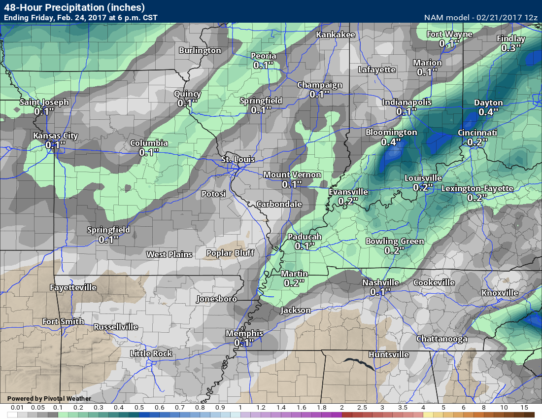
Here is the NAM model guidance for Thursday night into Friday night. It paints some showers further west than NOAA.
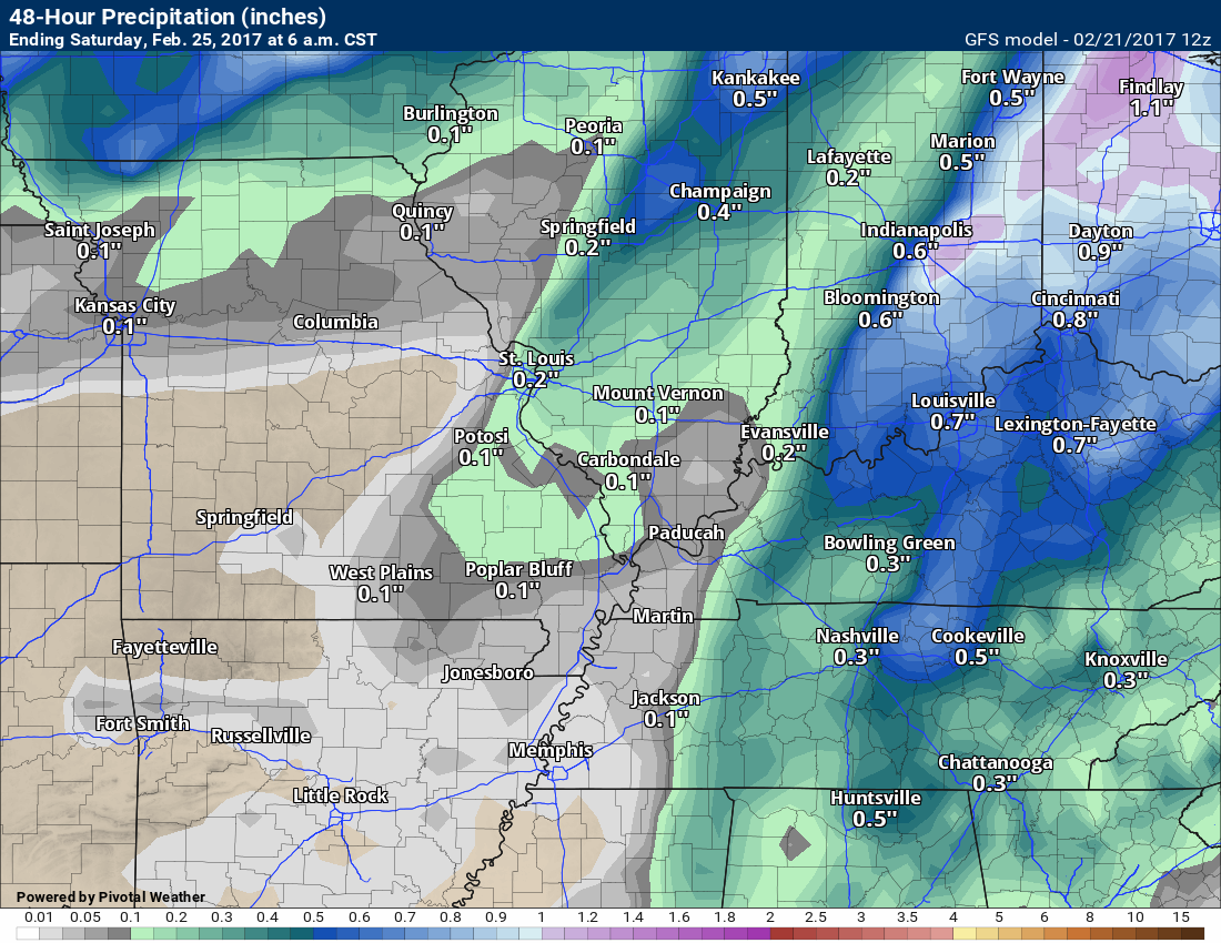
Here is the GFS model guidance for the same time period. The GFS also paints precipitation further west than NOAA.
I think there will be some showers further west of there the NWS/NOAA has painted precipitation.
Another system moves into the area late on Sunday into Monday.
High and Low-Temperature Outlook
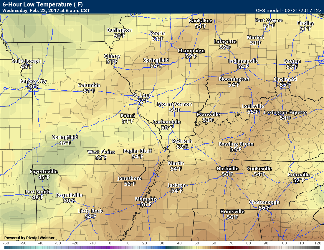
Wednesday low temperature forecast
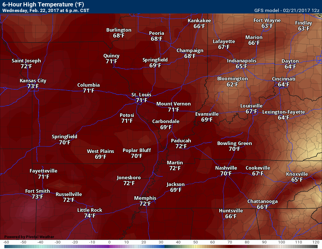
Wednesday afternoon high temperature forecast
Data does not agree on high temperatures for Wednesday afternoon. This could come down to cloud cover. Less cloud cover and you would have high temperatures.
Thursday low temperature forecast
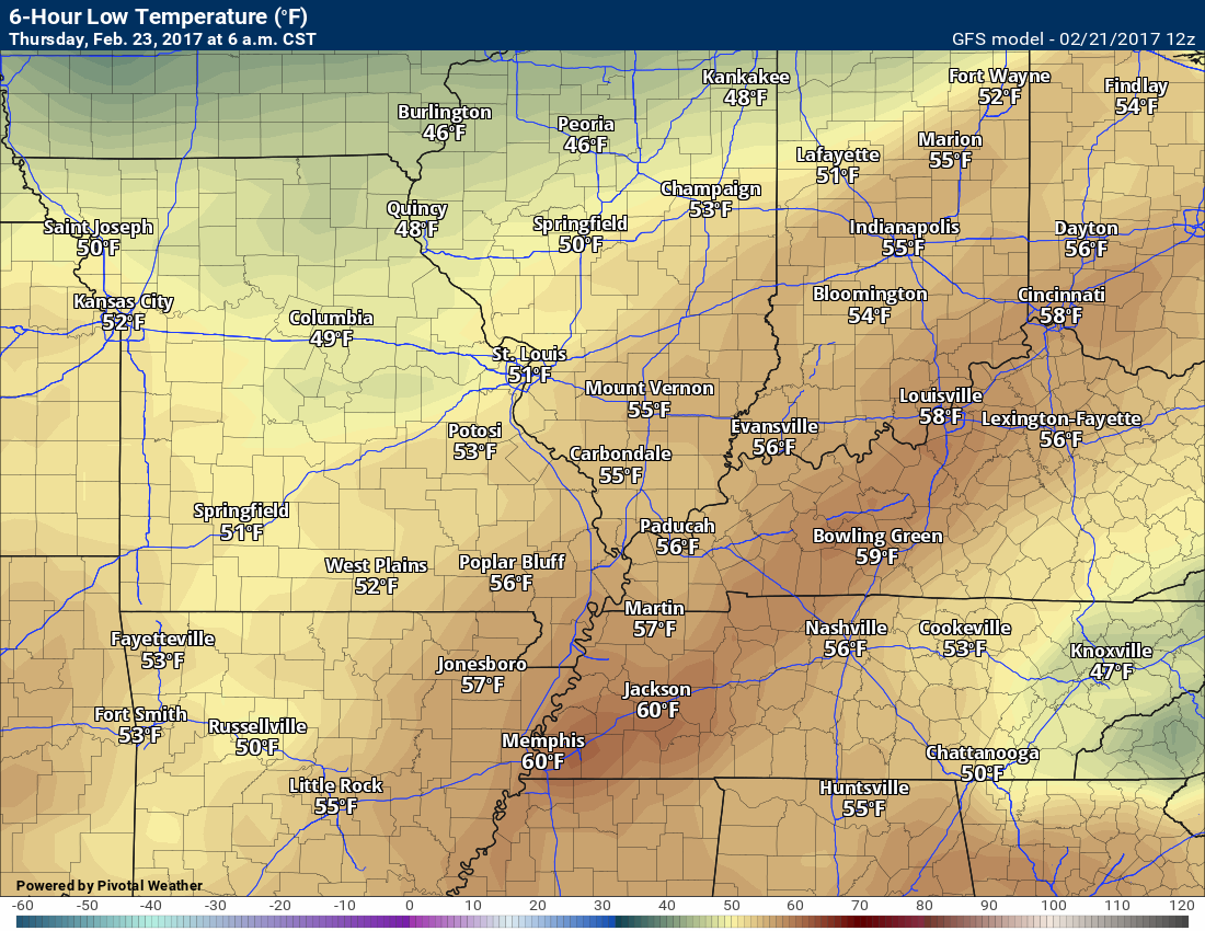
Thursday high temperature forecast
Temperatures will be dependent on cloud cover. Less clouds and you can tack on 3 to 6 degrees to this graphic.

Patchy dense fog possible Tuesday night/Wednesday morning.
Some strong storms can’t be ruled out on Friday.
.

Severe thunderstorm outlook.
Remember that a severe thunderstorm is defined as a thunderstorm that produces 58 mph winds or higher, quarter size hail or larger, and/or a tornado.
Tuesday night through Thursday: Severe weather is not anticipated. Lightning is possible on Monday night.
Thursday night into Friday night: Increasing chances for storms late Thursday night and more likely on Friday/Friday night. Some strong storms are a possibility. Monitor updated forecasts.
There remain some questions as to how far west the thunderstorm threat will be. Most of the data suggests the eastern half of our region stands a better chance for storms on Friday/Friday evening.
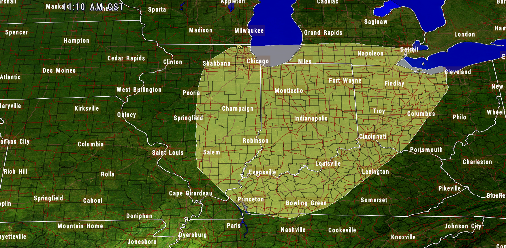
The Storm Prediction Center has outlined portions of the Ohio Valley for severe weather on Friday. Let’s monitor trends.
The yellow area is where the SPC is currently concerned. This will change several times between now and Friday.
Click image to enlarge.
.


We have regional radars and local city radars – if a radar does not update then try another one. Occasional browsers need their cache cleared. You may also try restarting your browser. That usually fixes the problem. Occasionally we do have a radar go down. That is why I have duplicates. Thus, if one fails then try another one.
During the winter you can track snow and ice by clicking the winterize button on the local city view interactive radars.
If you have any problems then please send me an email beaudodson@usawx.com
Interactive Weather Radar Page. Choose the city nearest your location: Click this link—
National interactive radar: Click this link.
Local interactive city radars include St Louis, Mt Vernon, Evansville, Poplar Bluff, Cape Girardeau, Marion, Paducah, Hopkinsville, Memphis, Nashville, Dyersburg, and all of eastern Kentucky. These are interactive radars. Local city radars – click here
Regional Radar


Here are the current river stage forecasts. You can click your state and then the dot for your location. It will bring up the full forecast and hydrograph.
..

The official 6-10 day and 8-14 day temperature and precipitation outlook. Check the date stamp at the top of each image (so you understand the time frame).
The forecast maps below are issued by the Weather Prediction Center (NOAA)


The latest 8-14 day temperature and precipitation outlook. Note the dates are at the top of the image. These maps DO NOT tell you how high or low temperatures or precipitation will be. They simply give you the probability as to whether temperatures or precipitation will be above or below normal.


Who do you trust for your weather information and who holds them accountable?
I have studied weather in our region since the late 1970’s. I have 39 years of experience in observing our regions weather patterns. My degree is in Broadcast Meteorology and a Bachelor’s of Science.
My resume includes:
Member of the American Meteorological Society.
NOAA Weather-Ready Nation Ambassador.
Meteorologist for McCracken County Emergency Management. I served from 2005 through 2015.
Meteorologist for McCracken County Rescue. 2015 through current
I own and operate the Southern Illinois Weather Observatory.
I am the chief meteorologist for Weather Talk LLC. I am the owner of Weather Talk LLC.
I am also a business owner in western Kentucky.
Recipient of the Mark Trail Award, WPSD Six Who Make A Difference Award, Kentucky Colonel, and the Caesar J. Fiamma” Award from the American Red Cross.
In 2005 I helped open the largest American Cross shelter in U.S. history in Houston, Texas. I was deployed to help after Hurricane Katrina and Hurricane Rita. I was a shelter manager of one of the Houston, Texas shelter divisions.
In 2009 I was presented with the Kentucky Office of Highway Safety Award.
Recognized by the Kentucky House of Representatives for my service to the State of Kentucky leading up to several winter storms and severe weather outbreaks.
If you click on the image below you can read the Kentucky House of Representatives Resolution.

I am also President of the Shadow Angel Foundation which serves portions of western Kentucky and southern Illinois.
There is a lot of noise on the internet. A lot of weather maps are posted without explanation. Over time you should learn who to trust for your weather information.
My forecast philosophy is simple and straight forward.
- Communicate in simple terms
- To be as accurate as possible within a reasonable time frame before an event
- Interact with you on Twitter, Facebook, email, texts, and this blog
- Minimize the “hype” that you might see on some television stations or through other weather sources
- Push you towards utilizing wall-to-wall LOCAL TV coverage during severe weather events
Many of the graphics on this page are from www.weatherbell.com
WeatherBell is a great resource for weather model guidance.


You can sign up for my AWARE email by clicking here I typically send out AWARE emails before severe weather, winter storms, or other active weather situations. I do not email watches or warnings. The emails are a basic “heads up” concerning incoming weather conditions