Milner and Orr Funeral Home and Cremation Services located in Paducah, Kentucky and three other western Kentucky towns – at Milner and Orr they believe in families helping families.
![]()

This forecast update covers far southern Illinois, far southeast Missouri, and far western Kentucky. See the coverage map on the right side of the blog.
Remember that weather evolves. Check back frequently for updates, especially during active weather.
Sunday – Cloudy with some flurries or snow showers possible. Highs in the 20’s to lower 30’s, but falling temperatures towards afternoon and evening. North wind 10-15 mph. Wind chills in the teens. My confidence in this part of the forecast verifying is high
Sunday night – Wind chills will drop below zero. Use care. Clouds, flurries, and cold. Temperatures falling to below zero over northern counties (near Mt Vernon) and towards the lower single digits over parts of southern Illinois – temperatures in the upper single digits and lower teens in far southern Illinois and western Kentucky. North wind 10-15 mph and gusty. Wind chills below zero at times. My confidence in this part of the forecast verifying is high
Monday – Bitter cold morning wind chills. Partly cloudy and cold. A flurry possible. Temperatures won’t recover much and may even fall on Monday afternoon. Morning lows will be bitterly cold. Highs in the teens. North winds 10-15 mph. My confidence in this part of the forecast verifying is high
Monday night – Some clouds early. Small chance for a flurry. Clearing and cold. Bitterly cold. Lows mostly in the single digits. Closer to 8-12 near KY/TN line. Calm winds becoming south after midnight. My confidence in this part of the forecast verifying is high
Tuesday – Some sun today (let’s all hope). Highs in the upper 20’s to middle 30’s. South or southwest winds at 5-10 mph. My confidence in this part of the forecast verifying is high

Current Temperatures Around The Local Area


An explanation of what is happening in the atmosphere over the coming days…
What a month this has turned out to be. Extreme weather for the eastern half of the United States has been the rule. It appears some extreme weather is going to continue.
Multiple snowstorm threats will occur to our south over the coming week. I am sure you will see this on the news.
For our region I am forecasting bitterly cold air to return by tonight into Tuesday morning. Additional shots of cold in the charts for the upcoming week, as well.
Let’s check out some temperature maps
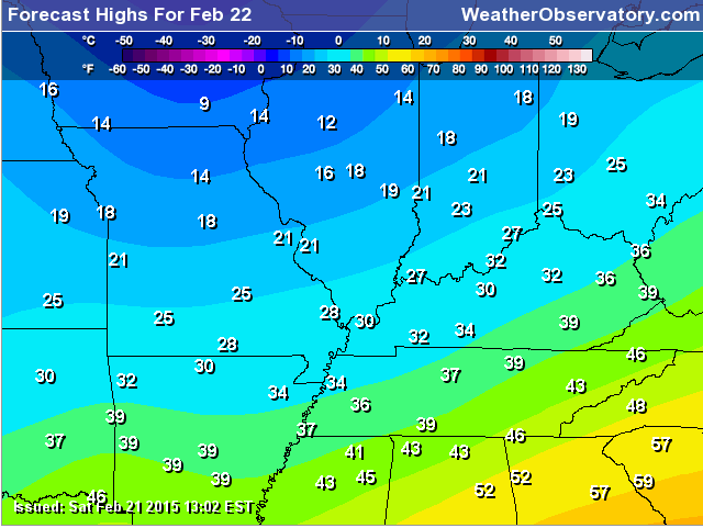
Today’s high temperatures
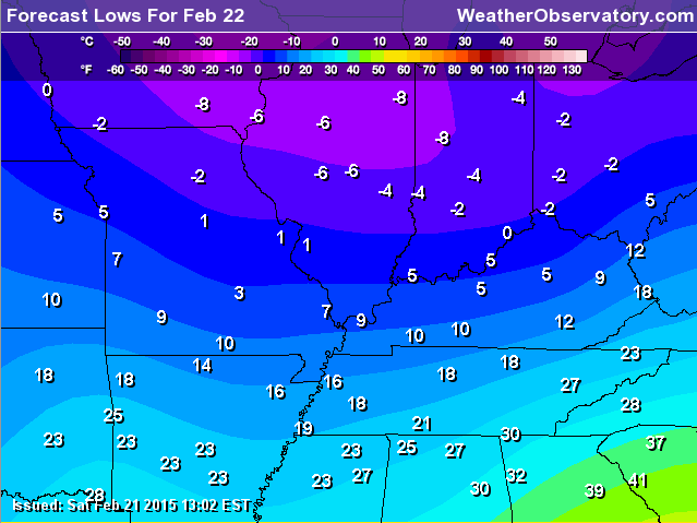
Tonight’s low temperatures
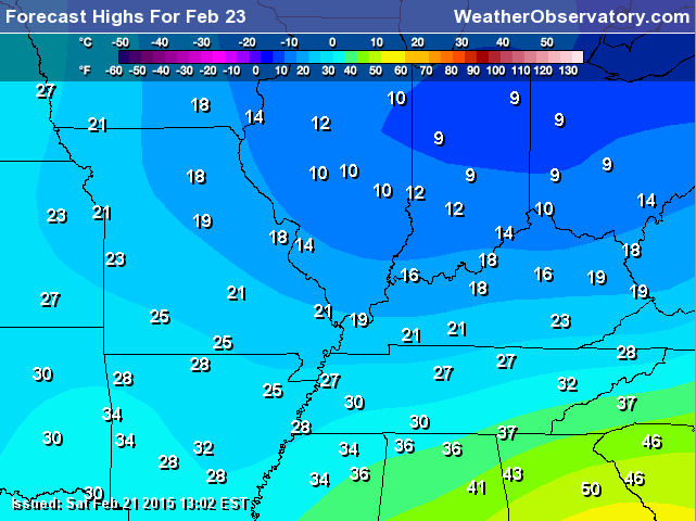
Monday’s high temperatures
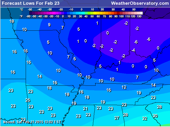
Monday night/Tuesday morning low temperatures
There is a lot of slush and ice remaining on roadways. I had hoped that some of this would melt off or wash away. Appears that has not been the case in many areas. Use care if you must be out driving on some of these roadways. There were a lot of accidents on Saturday.
Ice damming is common in our region. People are reporting water coming through their ceilings and windows. This is because of the clogged gutters. Unfortunately, this is going to continue for awhile. Although the cold temperatures might slow it down for now. Once it warms up again then it will be a problem.
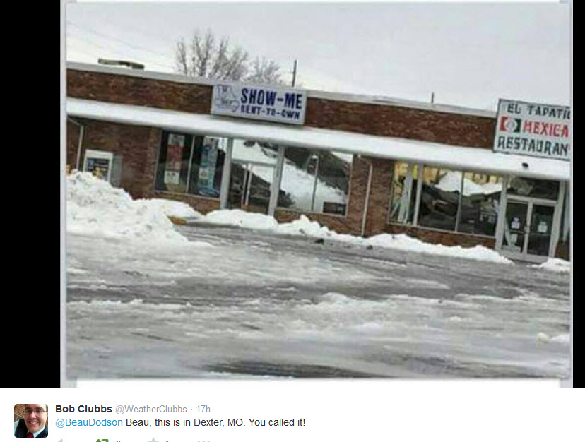
There have been several roof collapses reported over the past few days. Here is one in Dexter, Missouri. Thank you Bob Clubbs for sending me the photograph.
We will have a series of disturbances that will push through or near our region over the coming days. We will see an increase in clouds with each disturbance. Some light snow showers will also be possible. I will try to keep an eye on each one of these systems in case they pop some light snow. Not expecting anything significant.
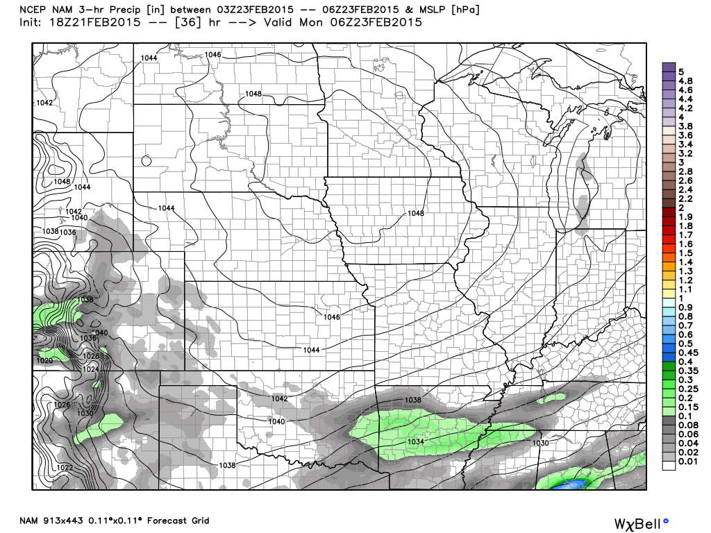
Here is one system tonight (late) – light skiff of snow down in Arkansas and Tennessee. Might clip our area with flurries. The grey area represents light flurries or a snow shower.
See the extended discussion concerning some systems to monitor towards the end of the new work week.
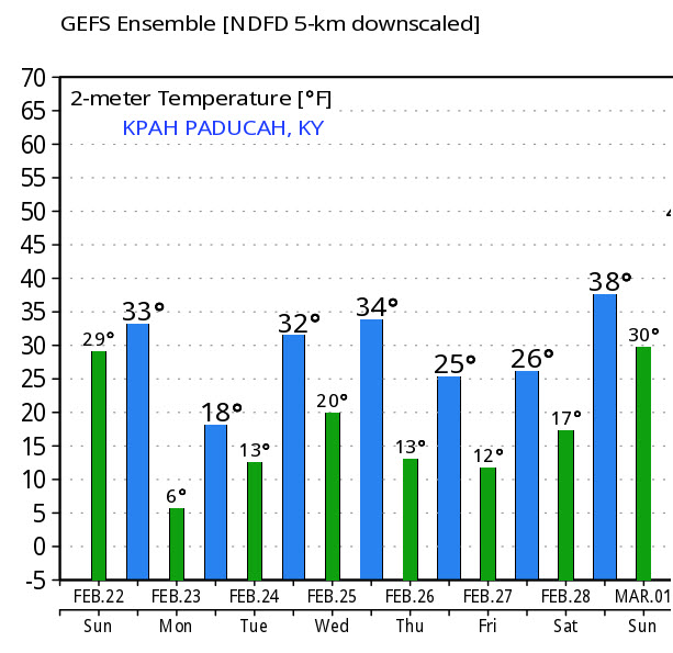
Let’s check out how many degrees below normal temperatures will be on Monday morning. These are not the actual air temperatures. These are the departures. In other words, how many degrees above or below the norms (normal highs for this time of the year are around 49 degrees and normal lows are around 29 degrees). Those are some very big departures in our region.

I pulled up the expected highs and lows for Paducah, KY through Friday. Well below normal.

Trover’s Equipment and Lawn Care Facebook Page – Family owned and operated! They are a dealer for Snapper, Simplicity, Snapper Pro, Bad Boy Mowers, and Intimidator Utility Vehicles. They are a Stihl and Dolmar power products dealer. They also are a dealer for Briggs & Stratton, Kohler gas & diesel engines, and Kawasaki engines. They service and repair just about any brand.

My big concern for Sunday morning will be slush covered roads that have iced over. Multiple accidents were reported on Sunday in the region, some serious. No doubt the roads will be slick again this morning and today. Use care if you are out and about.
Concerned about bitterly cold air tonight with lows back into the single digits or lower in some counties. Pipe busting cold is not finished with our region. Crazy weather pattern. Sustained cold like this is not the common forecast for late February. Not these temperatures and not for this period of time.
There have been numerous reports of not only water pipes freezing, but also some larger water mains. This may continue to be a problem.
Check out our newest sponsors $5 meal! The DQ Grill and Chill (located across from Noble Park in Paducah, Kentucky) is the newest WeatherTalk Blog sponsor! A local business helping to sponsor the weather information that you have come to love so much.
They have a Facebook Page and I encourage you to check it out. DQ Grill and Chill on Facebook


The wild card tells you where the uncertainties are in the forecast
Wild card in this forecast – the wild card in today’s forecast will be overnight lows tonight and tomorrow night. It appears some areas may dip into the lower single digits. I would not be surprised to see below zero readings over the northern counties of southern Illinois. Same question for Monday night. Bitterly cold air for our region, once again.

Can we expect severe thunderstorms over the next 24 to 48 hours? Remember that a severe thunderstorm is defined as a thunderstorm that produces 58 mph winds or higher, quarter size hail or larger, and/or a tornado.
Thunderstorm threat level is ZERO


Will I need to take action?
Black ice. Slick roads will cause problems this morning. Many roads are still covered in slush and ice. That will refreeze each night. Use care if you are out and about.
No doubt there will be some more school closings this week. Might take some time to remove all of this ice from roadways. This is especially true because of the cold temperatures.
More pipe busting cold is forecast for the region. I know there have already been a lot of busted pipes from the past 2 weeks. There will be more problems this week.

How much precipitation should we expect over the next few days?
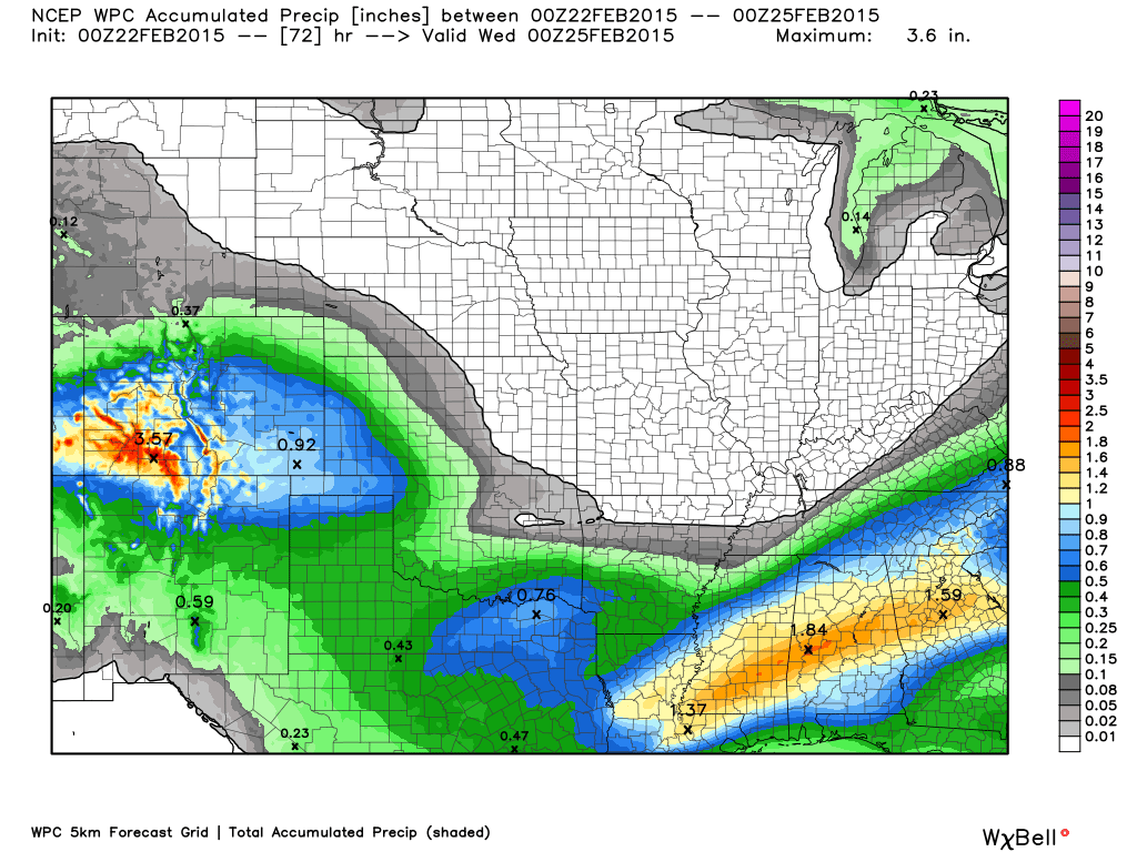
Thankfully our heavy precipitation has moved out. Some light snow showers or flurries will be possible today as another blast of cold air arrives for the region. Little or no accumulation is forecast.
Precipitation outlook
We have a new sponsor! G&C Multi-Services out of Paducah, Kentucky. G & C Multi-Services is a service provider in Western Kentucky that provides industrial and commercial equipment fabrication, machine troubleshooting, repair and maintenance, and installation. They can custom fabricate steel, stainless, and aluminum products per customer specifications.
Visit their web-site here. Or click the ad below! They have a Facebook page and it can be viewed here.


Cold weather will be the rule over the coming week. Weak disturbances will move through a fast jet stream flow and occasional snow flurries or snow showers may pop up in the forecast. There are many shortwaves (disturbances) to monitor. Most of them dive so far south that they bring little or any impact to our region.
Occasionally we get a little surprise out of these type of systems. Monitor updates this week in case some light snow pops up in the forecast.
I do have some snow flurries or showers in the forecast for today/this afternoon.
Jim Rasor has a new blog. Check it out when you have time http://mylocalweather.net/forum/home

This section of the blog is speculative forecast information. Because it is past the range of what meteorologists can forecast accurately, it should be considered speculation. Anything past day 5 is considered a long range forecast.
An active southern jet stream will keep forecasters on the toes over the next few weeks. Fast jet stream with energy diving out of the northwest and energy coming in from the southwest. These combine and we end up with precipitation.
Remember me saying this a few weeks ago. After a sleeping period for the southern jet (in our region) it suddenly came alive. And BOOM we ended up with multiple winter storms and bitter cold.
Will that happen again? We will see. There are rumors and hints of storms on the models. Many of them stay south of our region.
There is one storm in particular that I have been watching. That is the one towards next Friday and Saturday/Sunday. I see the National Weather Service mentioned it today in their area forecast discussion. I have looked over today’s data and it does show up on some of the models, but not all.
Typically in the long range we just take a wait and see approach. And so that is what we will do this time around.
The models want to develop a winter storm over Oklahoma and Texas and then diving it down into the southern United States. From there the data takes it up into the Tennessee Valley. This would be a decent storm track for precipitation in our region.
Way too far out to know whether this will come together or not. Monitor updates.
The big story over the coming 7 days will be the cold air. No warm up in sight. Not what you want to hear. I know.
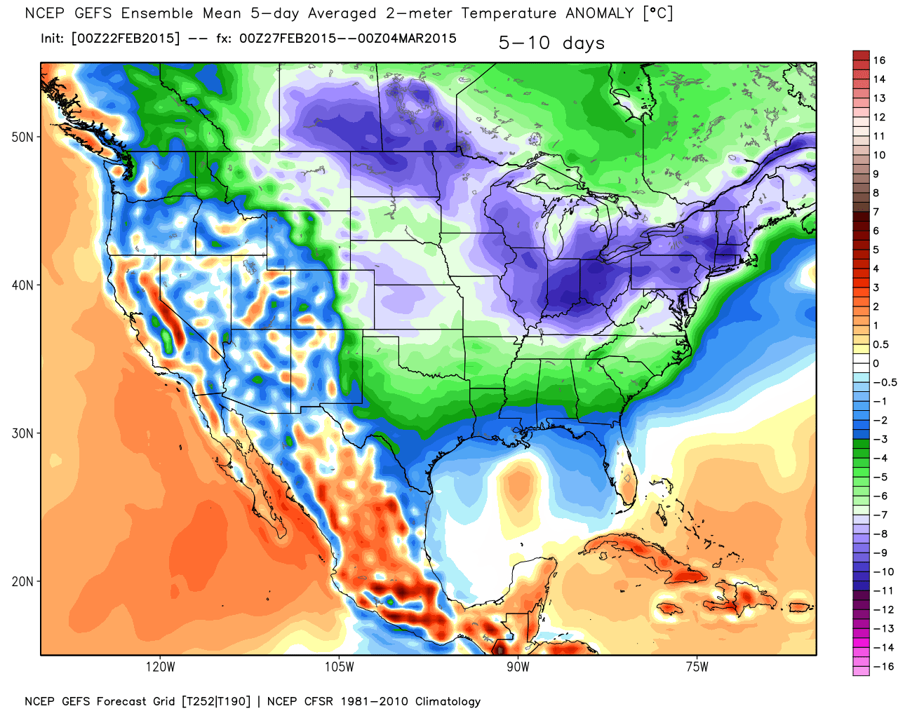
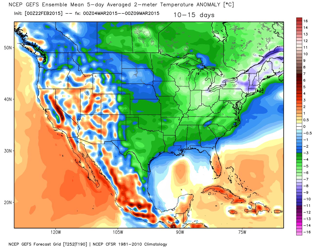
Let’s take a look at the 5 day anomalies from the GFS model. If you were to average out the 5 day periods, on each of these maps, would you be above or below normal? And, how many degrees above or below normal. These maps are not pointing towards warm weather. That is for sure.
This time of the year our normal high temperatures are 49 degrees and our normal low temperatures are around 29 degrees. Needless to say, it appears we are going to be well below those numbers.
The first five day period will run from February 23rd through February 27th
WELL below normal temperatures. These are some extreme numbers.
Remember, these are not the temperatures. These numbers represent how many degrees below normal we will average (these numbers are Celsius)

The next 5 day period runs from February 27th through March 3rd. Still below normal.
The last 5 day period runs from March 4th through March 8th. Still below normal. Looks to me like we are in for a stretch of below normal temperatures.
We have been setting records left and right. Here are some of them:
PUBLIC INFORMATION STATEMENT
NATIONAL WEATHER SERVICE PADUCAH KY
1230 AM CST SUN FEB 22 2015

...RECORD COLD FEBRUARY 2015...

RECORD COLD LATE SEASON WEATHER HAS BROKEN NUMEROUS RECORDS ACROSS
THE QUAD-STATE REGION FOR FEBRUARY. HERE IS A BREAKDOWN OF THE
NUMBERS:

PADUCAH: (RECORDS DATE BACK TO 1937)
- RECORD LOWS WERE BROKEN ON FEB 17TH (-5 DEGREES), FEB 18TH (0
DEGREES), FEB 19TH (-10 DEGREES), AND FEB 20TH (-9 DEGREES).
- THE 10 BELOW ZERO TEMPERATURE ON FEB 19TH WAS THE COLDEST
TEMPERATURE EVER RECORDED THIS LATE IN THE SEASON AND THE LOWEST
TEMPERATURE PADUCAH HAS SEEN SINCE IT DROPPED TO 13 BELOW ZERO ON
JANUARY 19TH, 1994.
- RECORD COLD HIGH WAS SET ON FEB 19TH OF 18 DEGREES. THIS WAS ALSO
IMPRESSIVE AS IT WAS ONLY THE 3RD TIME ON RECORD WITH A HIGH BELOW
20 THIS LATE IN THE SEASON. PADUCAH HASN'T SEEN A HIGH THIS COLD
BEYOND FEB 17TH SINCE IT ONLY MANAGED 17 DEGREES ON FEB 21, 1963.
- THE 10.8 INCHES OF SNOWFALL THAT FELL ON FEB 16, 2015 WAS THE
LARGEST DAILY SNOWFALL ON RECORD FOR THE MONTH OF FEBRUARY AND THE
3RD LARGEST FOR ANY MONTH.
- THE MONTHLY SNOWFALL TOTAL STANDS AT 13.0 INCHES WHICH WOULD RANK
AS THE 2ND SNOWIEST FEBRUARY BEYOND THE 15.3 INCHES THAT FELL IN
FEBRUARY 1993.
- PADUCAH IS ON PACE TO HAVE ITS 2ND COLDEST FEBRUARY ON RECORD ONLY
BEHIND 1978 WHEN THE AVERAGE TEMPERATURE WAS 24.4 DEGREES.
- PUTTING THIS ALL INTO PERSPECTIVE, PADUCAH HASN'T SEEN A COLD
STRETCH OF THIS MAGNITUDE THIS LATE IN THE SEASON SINCE 1960 WHEN
THERE WAS A 6 DAY PERIOD WITH HIGHS BELOW FREEZING FROM FEB 29TH
THROUGH MARCH 5TH AND A 17 DAY PERIOD WITH HIGHS BELOW 40 ENDING ON
MARCH 12TH. LOW TEMPERATURES DURING THAT SPAN DIPPED BELOW ZERO
TWICE IN EARLY MARCH WHICH IS STILL THE ONLY OCCURRENCES OF BELOW
ZERO READINGS IN MARCH.

EVANSVILLE: (RECORDS DATE BACK TO 1897)
- RECORD LOWS WERE BROKEN ON FEB 19TH (-6 DEGREES) AND FEB 20TH (-7
DEGREES).
- THE 7 BELOW ZERO TEMPERATURE ON FEB 20TH WAS THE COLDEST
TEMPERATURE EVANSVILLE HAS SEEN SINCE IT DROPPED TO 11 BELOW ZERO ON
CHRISTMAS 2004.
- RECORD COLD HIGH WAS SET ON FEB 19TH OF 11 DEGREES. IMPRESSIVELY
THIS IS ONLY THE 2ND TIME WITH HIGH TEMPERATURES BELOW 15 THIS LATE
IN THE SEASON. THE OTHER OCCURRENCE WAS ON FEB 21, 1963 WHEN THE
HIGH WAS ALSO 11.
- EVANSVILLE IS ON PACE TO HAVE ITS 3RD COLDEST FEBRUARY ON RECORD
BEHIND 1978 WHEN THE AVERAGE TEMPERATURE WAS 21.0 AND 1979 WITH AN
AVERAGE OF 24.6.
- PUTTING THIS ALL INTO PERSPECTIVE, EVANSVILLE HASN'T SEEN A COLD
STRETCH OF THIS MAGNITUDE THIS LATE IN THE SEASON SINCE 1960 WHEN
THERE WAS A 9 DAY PERIOD WITH HIGHS BELOW FREEZING FROM FEB 29TH
THROUGH MARCH 8TH AND 19 STRAIGHT DAYS BELOW 40 ENDING ON MARCH
14TH. LOW TEMPERATURES DIPPED AS LOW AS 9 BELOW ZERO DURING THAT
SPAN WHICH IS THE COLDEST TEMPERATURE ON RECORD IN MARCH.

CAPE GIRARDEAU: (RECORDS DATE BACK TO JUNE 1960)
- RECORD LOWS WERE BROKEN ON FEB 16TH (-2 DEGREES), FEB 17TH (-11
DEGREES), FEB 18TH (-7 DEGREES), FEB 19TH (-14 DEGREES), AND FEB
20TH (11 DEGREES).
- THE 14 BELOW ZERO TEMPERATURE ON FEB 19TH WAS THE COLDEST
TEMPERATURE EVER RECORDED IN FEBRUARY AND FOR THIS LATE IN THE
SEASON. THE PREVIOUS FEBRUARY RECORD WAS 8 BELOW ZERO MOST RECENTLY
SET ON FEB 3, 1996.
- TEMPERATURES BELOW ZERO ARE RARE THIS LATE IN THE SEASON AND IN
FACT THE -14 ON FEB 19TH IS NOW THE LATEST OCCURRENCE OF A
TEMPERATURE BELOW ZERO ON RECORD. THE PREVIOUS RECORD WAS -2 SET ON
FEBRUARY 18TH 1993.
- RECORD COLD HIGHS WERE SET ON FEB 15TH (23 DEGREES), FEB 16TH (22
DEGREES), AND FEB 19TH (18 DEGREES). THE 18 DEGREES ON FEB 19TH WAS
ONLY THE 3ND TIME ON RECORD WITH A HIGH BELOW 20 THIS LATE IN THE
SEASON. THE LATEST OCCURRENCE WAS SET ON FEB 21, 1963 WHEN IT ONLY
HIT 18.
- CAPE GIRARDEAU IS ON PACE TO HAVE ITS 2ND COLDEST FEBRUARY ON
RECORD BEHIND 1978 WHEN THE AVERAGE TEMPERATURE WAS 23.9.
- CAPE GIRARDEAU HASN'T SEEN A COLD STRETCH OF THIS MAGNITUDE THIS
LATE IN THE SEASON SINCE RECORDS BEGAN IN JUNE OF 1960.

WELL BELOW AVERAGE TEMPERATURES ARE EXPECTED TO CONTINUE THROUGH
THIS COMING WEEK SO MORE RECORDS ARE BOUND TO BE SET ESPECIALLY ON
MONDAY AND POSSIBLY AGAIN LATER IN THE WEEK. THIS LIST WILL BE
UPDATED ACCORDINGLY WHEN THIS HAPPENS.

$$

Who do you trust for your weather information and who holds them accountable?
I have studied weather in our region since the late 1970’s. I have 37 years of experience in observing our regions weather patterns. My degree is in Broadcast Meteorology from Mississippi State University and an Associate of Science (AS). I am currently working on my Bachelor’s Degree in Geoscience. Just need to finish two Spanish classes!
I am a member of the American Meteorological Society. I am a NOAA Weather-Ready Nation Ambassador. And, I am the Meteorologist for McCracken County Emergency Management.
I own and operate the Southern Illinois Weather Observatory.
There is a lot of noise on the internet. A lot of weather maps are posted without explanation. Over time you should learn who to trust for your weather information.
My forecast philosophy is simple and straight forward.
- Communicate in simple terms
- To be as accurate as possible within a reasonable time frame before an event
- Interact with you on Twitter, Facebook, and the blog
- Minimize the “hype” that you might see on television or through other weather sources
- Push you towards utilizing wall-to-wall LOCAL TV coverage during severe weather events
I am a recipient of the Mark Trail Award, WPSD Six Who Make A Difference Award, Kentucky Colonel, and the Caesar J. Fiamma” Award from the American Red Cross. In 2009 I was presented with the Kentucky Office of Highway Safety Award. I was recognized by the Kentucky House of Representatives for my service to the State of Kentucky leading up to several winter storms and severe weather outbreaks.
If you click on the image below you can read the Kentucky House of Representatives Resolution.

I am also President of the Shadow Angel Foundation which serves portions of western Kentucky and southern Illinois.

We have regional radars and local city radars – if a radar does not seem to be updating then try another one. Occasional browsers need their cache cleared. You may also try restarting your browser. That usually fixes the problem. Occasionally we do have a radar go down. That is why I have duplicates. Thus, if one fails then try another one.
If you have any problems then please send me an email beaudodson@usawx.com
WEATHER RADAR PAGE – Click here —
We also have a new national interactive radar – you can view that radar by clicking here.
Local interactive city radars include St Louis, Mt Vernon, Evansville, Poplar Bluff, Cape Girardeau, Marion, Paducah, Hopkinsville, Memphis, Nashville, Dyersburg, and all of eastern Kentucky – these are interactive radars. Local city radars – click here
NOTE: Occasionally you will see ground clutter on the radar (these are false echoes). Normally they show up close to the radar sites – including Paducah.

Regional Radar – Click on radar to take you our full radar page.


Regional Radar
![]()
Current WARNINGS (a warning means take action now). Click on your county to drill down to the latest warning information. Keep in mind that there can be a 2-3 minute delay in the updated warning information.
I strongly encourage you to use a NOAA Weather Radio or warning cell phone app for the most up to date warning information. Nothing is faster than a NOAA weather radio.


Color shaded counties are under some type of watch, warning, advisory, or special weather statement. Click your county to view the latest information.

Missouri Warnings

Illinois Warnings

Kentucky Warnings

Please visit your local National Weather Service Office by clicking here. The National Weather Service Office, for our region, is located in Paducah, Kentucky. They have a lot of maps and information on their site. Local people…local forecasters who care about our region.


Here is the official 6-10 day and 8-14 day temperature and precipitation outlook. Check the date stamp at the top of each image (so you understand the time frame).
The forecast maps below are issued by the Weather Prediction Center (NOAA).


The latest 8-14 day temperature and precipitation outlook. Note the dates are at the top of the image. These maps DO NOT tell you how high or low temperatures or precipitation will be. They simply give you the probability as to whether temperatures or precipitation will be above or below normal.


Many of my graphics are from www.weatherbell.com – a great resource for weather data, model data, and more


This blog was inspired by ABC 33/40’s Alabama Weather Blog – view their blog
Current tower cam view from the Weather Observatory- Click here for all cameras.

Southern Illinois Weather Observatory

The Weather Observatory

Southern Illinois Weather Observatory
WSIL TV 3 has a number of tower cameras. Click here for their tower camera page & Illinois Road Conditions

Marion, Illinois
WPSD TV 6 has a number of tower cameras. Click here for their tower camera page & Kentucky Road Conditions & Kentucky Highway and Interstate Cameras

Downtown Paducah, Kentucky
Benton, Kentucky Tower Camera – Click here for full view

Benton, Kentucky

I24 Paducah, Kentucky

I24 Mile Point 9 – Paducah, KY

I24 – Mile Point 3 Paducah, Kentucky

You can sign up for my AWARE email by clicking here I typically send out AWARE emails before severe weather, winter storms, or other active weather situations. I do not email watches or warnings. The emails are a basic “heads up” concerning incoming weather conditions.