
5 PM
Ice event underway. Sleet and freezing rain is spreading across the area. Numerous accidents have been reported in western Kentucky and southeast Missouri. Some serious accidents with serious injuries.
Avoid travel tonight if at all possible. This is a dangerous driving event with ice covered roads.
Precipitation will increase through the overnight hours. Heaviest precipitation will be later this evening – after 7 or 8 pm. This will last into the wee hours of the morning.
There continues to be low confidence as to where the freezing line will end up later tonight. Hope for sleet. Sleet will help keep the damage to trees down.
The heaviest ice accumulation is likely to be somewhere along a line from Piedmont, Missouri towards Paducah, Kentucky – northward. Areas of northwest Kentucky will have a lot of sleet and freezing rain, as well.
I am thinking the freezing line makes it into west Kentucky later tonight. Not sure about southern Illinois. Perhaps far southern Illinois. Ice accumulation of 0.25″-0.40″ will be possible. Locally higher amounts.
Thunderstorms will enhance totals tonight. Thunderstorms with freezing rain and sleet are likely to occur.
3 PM UPDATE
I am increasing ice totals to 0.15 to 0.30″ with locally heavy amounts possible. Extreme driving conditions are likely to develop this evening and tonight.
Travel is not recommended tonight. Please avoid travel once the freezing rain begins – roads will become very slick.
Thunderstorms with freezing rain and sleet are likely to develop. This will enhance totals.
9 AM Update
The winter storm warning has been upgraded to a winter weather advisory for southern Illinois and western Kentucky – southeast Missouri (other NWS Paducah forecast area)
Winter storm warnings cover parts of AR and TN. Ice storm warnings for part of west Tennessee, as well.
Everything is on track for precipitation to begin later this morning and mainly this afternoon and evening.
Ice will accumulate on trees to about 0.10″-0.15″ with locally higher amounts likely over parts of southeast MO, southern IL, and northwest KY.
To bring down power lines you need about 0.50″ of freezing rain.
Gusty winds could be an issue during this ice event. Keep that in mind.
Here are the times that I have the freezing rain changing over to plain old rain
We have our first sponsor for the blog. Milner and Orr Funeral Home and Cremation Services located in Paducah, Kentucky and three other western Kentucky towns – at Milner and Orr they believe in families helping families.
![]()

This forecast update covers far southern Illinois, far southeast Missouri, and far western Kentucky. See the coverage map on the right side of the blog.
Remember that weather evolves. Check back frequently for updates, especially during active weather.
*** CHECK BACK OFTEN TODAY HERE AND ON THE FACEBOOK WEATHER PAGE…
MULTIPLE UPDATES WILL BE NECESSARY *** I will post updates at the very top of the page.
Friday – Winter storm developing with hazardous driving conditions likely later today. Cloudy with flurries possible this morning. Snow and sleet rapidly developing late morning into the afternoon hours. Precipitation will spread from southwest to northeast over the area. Precipitation will develop overhead. Temperatures starting out in the single digits and lower teens and then rising into the 20’s this afternoon. Roads will become slick this afternoon as precipitation develops and becomes heavier. Once freezing rain develops then roads will become a skating rink. Travel will be discouraged later today. My confidence in this part of the forecast verifying is high
Morning School Bus Stop Weather – Cloudy in the morning. Bitter cold. Snow flurries possible. Temperatures will be around 10 degrees. Light winds. Chances of schools being delayed because of the weather HIGH
—————————————————————————————-
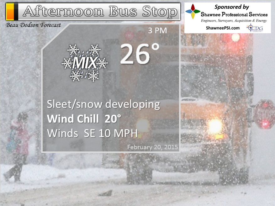
Afternoon School Bus Stop Weather – Cloudy with snow and sleet forming. Temperatures will be in the 20’s. Southeast winds at 10 mph.
Friday night – Sleet and freezing rain. Roads will be a skating rink when the freezing rain is occurring. Do not drive if you don’t have to. Freezing rain may change to all rain after midnight. Locally heavy rain possible. Temperatures rising into the 30’s. Southeast winds at 10-20 mph. My confidence in this part of the forecast verifying is medium
IF THE 32 DEGREE LINE DOES NOT MOVE NORTH QUICK ENOUGH THEN WE ARE IN TROUBLE WITH SIGNIFICANT FREEZING RAIN/ICE
Saturday – Rain likely. Locally heavy rain possible. Rainfall totals may exceed 1″ in many counties. Temperatures will mostly be in the 30’s. Southeast winds at 10-20 mph and gusty. Winds switching to the northwest in the afternoon. My confidence in this part of the forecast verifying is low
Saturday night – Rain ending. A chance for snow showers. Low temperatures in the 20’s. Northwest winds at 10 mph. My confidence in this part of the forecast verifying is medium
Sunday – Cloudy with a chance for flurries or snow showers. Cold. Highs in the 20’s. My confidence in this part of the forecast verifying is medium


The School Bus Stop Forecast is brought to your by Shawnee Professional Services. For more information click here

Shawnee Professional Services & Civil Design Group have been providing Land Surveying, Engineering, Grant Administration and Acquisition services for the past 20 years.
Currently Licensed in Illinois, Kentucky, Missouri, Indiana, and Tennessee; please contact Shawnee for any Land Surveying or Engineering needs.
Shawnee’s company size allows them to devote individual attention to each client and to approach each project with the required thoroughness to successfully complete the project, large or small.
Shawnee combines innovative thinking and proven techniques, completing projects cost-effectively for their clients. Visit Shawnee’s website at shawneepsi.com for more information. Shawnee has offices in Paducah, KY, Vienna, IL and Benton, IL.
Current Temperatures Around The Local Area


WEATHER RADAR PAGE – Click here —
We also have a new national interactive radar – you can view that radar by clicking here.

An explanation of what is happening in the atmosphere over the coming days…
Anyone tired of this yet? Thought so.
Our next winter storm is already moving into the area. Radar will light up later this morning and through the afternoon hours. Precipitation will develop from the southwest towards the northeast. It will also form directly overhead. Radar will quickly fill in with each passing hour later today.
I do not recommend travel later this afternoon into tonight. Roads may become a skating rink once freezing rain develops.
There are a lot of uncertainties in this forecast. The exact position of the 32 degree line is going to be critical in this event forecast verifying.
IF THE 32 DEGREE LINE DOES NOT MOVE NORTH QUICK ENOUGH THEN WE ARE IN TROUBLE WITH SIGNIFICANT FREEZING RAIN/ICE
Snow accumulations for far southeast Missouri, southern Illinois, and western Kentucky should be less than 3″. This is more of a sleet and freezing rain event that will transition into a rain event.
Sleet may accumulate one quarter inch. Sleet are the little round bouncy bb like ice pellets.
Freezing rain may accumulate in the 0.10″-0.15″ range. If the freezing line does not move in as forecast then heavier amounts of freezing rain will occur.
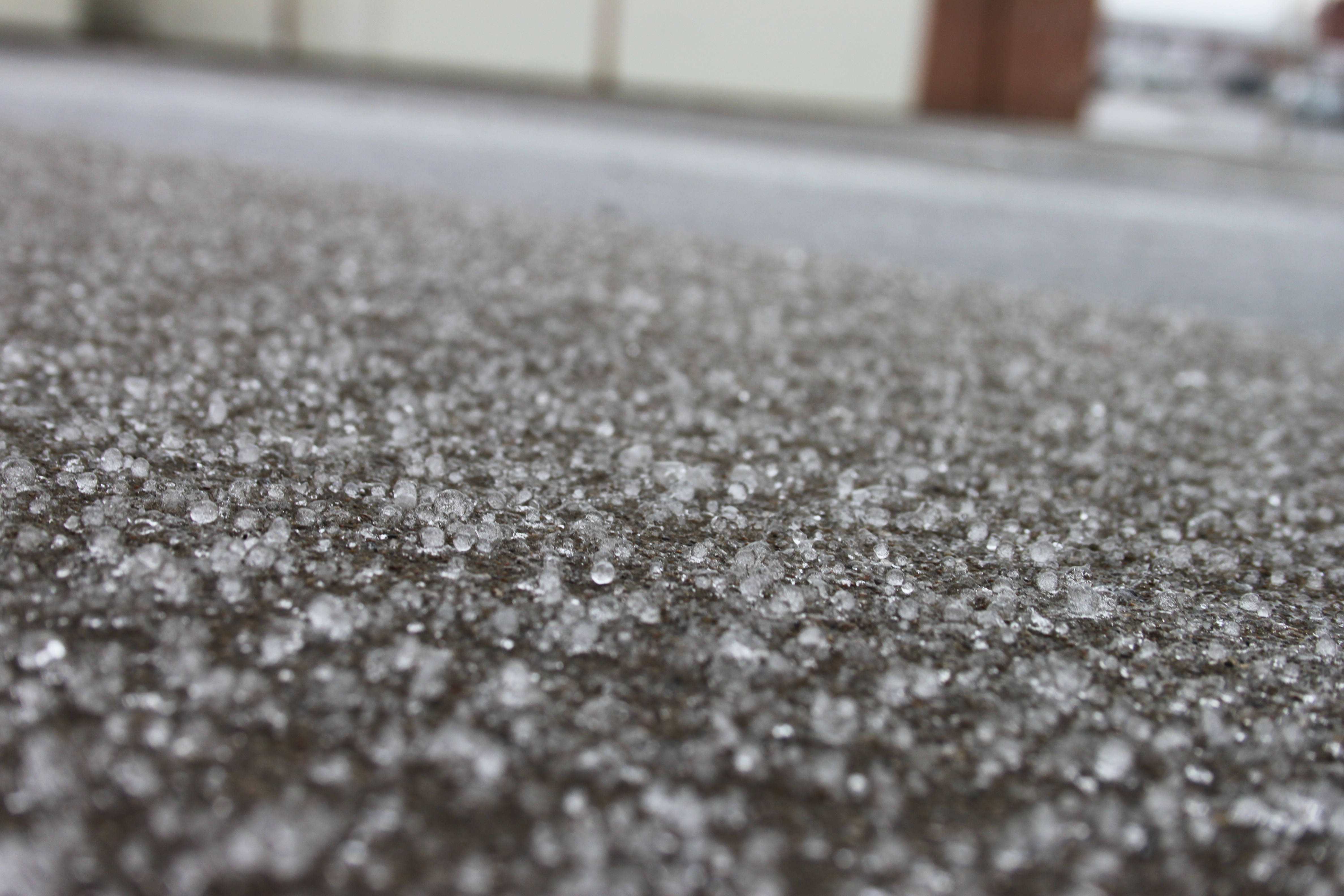
This is sleet – little pellets of ice.
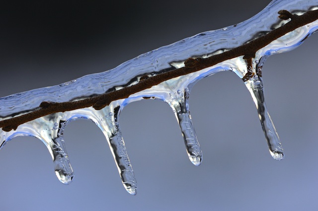
This is freezing rain. Rain that falls from the sky and instantly freezes on objects.
The million dollar question is what time does the 32 degree line reach your location. Right now I have it reaching western Kentucky between 9 pm and 1 am. I have it moving through far southern Illinois between 10 pm and 2 am. Northern parts of the region and northeast counties it will take longer to arrive there. That means Owensboro, Kentucky will stay snow, sleet, and freezing rain longer.
IF IF IF the freezing line does not accelerate through the area then heavier freezing rain totals will occur. This could be a problem.
Right now I feel pretty good about the 32 degree line moving into and through our area by the hours mentioned above. As new information arrives I will update this page throughout the day – watch for updates at the top of the page.
Rainfall totals could cause some problems. Many storm drains are clogged with snow and ice. This means the water may not be able to swiftly drain away. Ponding of water could occur.
Some large span roofs may collapse under the weight of the snow and ice combined with more rain. This is already being reported in some areas just from the snow that has already fallen.
Heavy rain could quickly cause stream rises, as well. Monitor any warnings that may need to be issued.
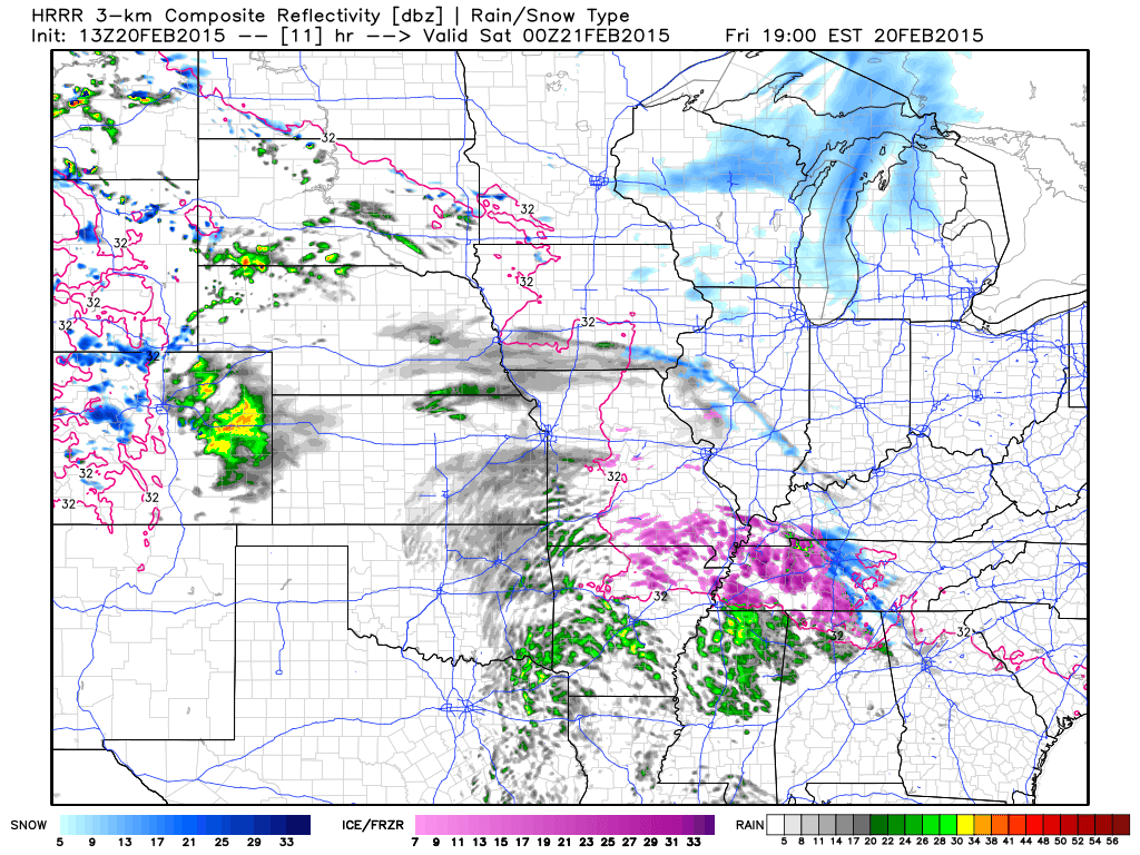
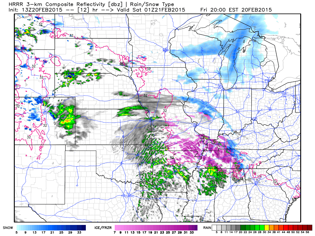
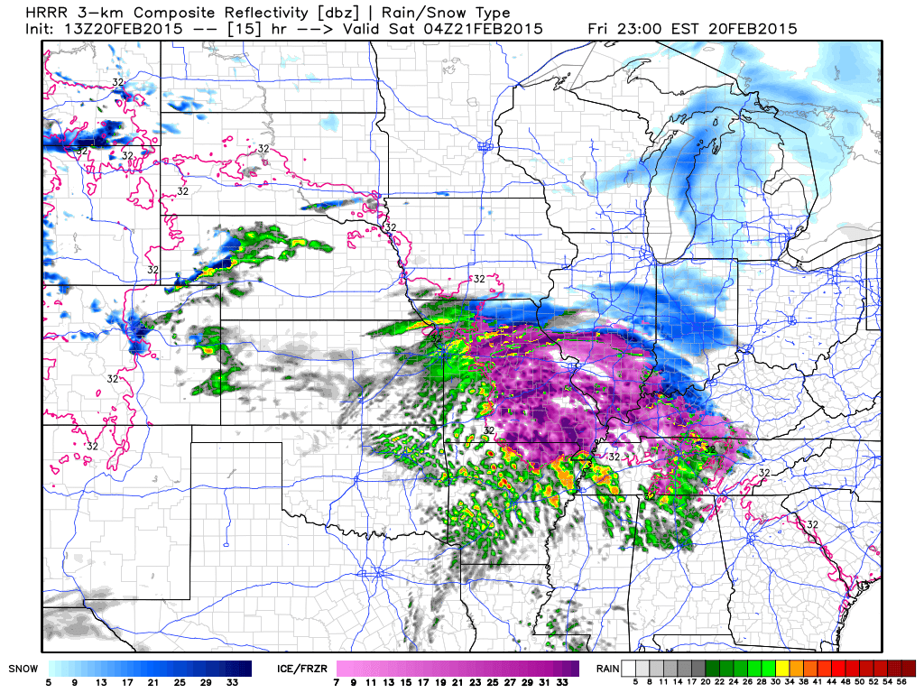
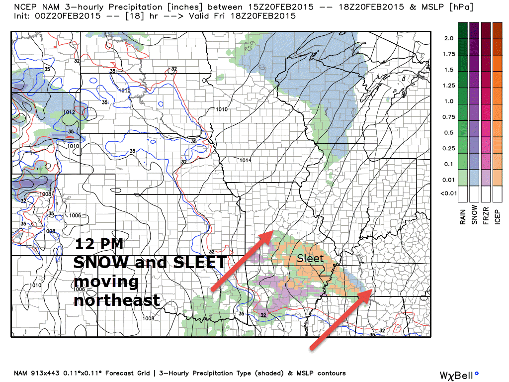
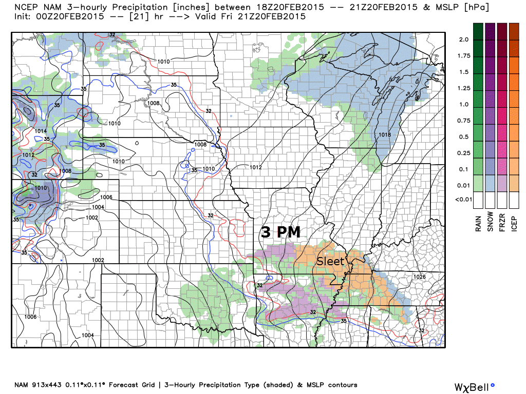
Here is what the future-cast radar is showing for this event
By 12 pm you can see snow and sleet moving northeast through southeast Missouri
By 3 pm precipitation has already spread northeast into much of the area. Snow and sleet.
Rainfall totals will be in the 1-2″ range. Here is one model’s opinion on totals. You can see the streaks of locally heavy rain across the area. Note the moisture spreading northward from the Gulf of Mexico. Pretty cool to see that on the models.
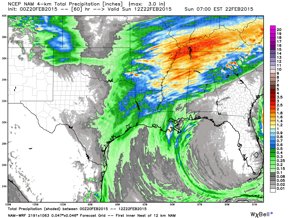
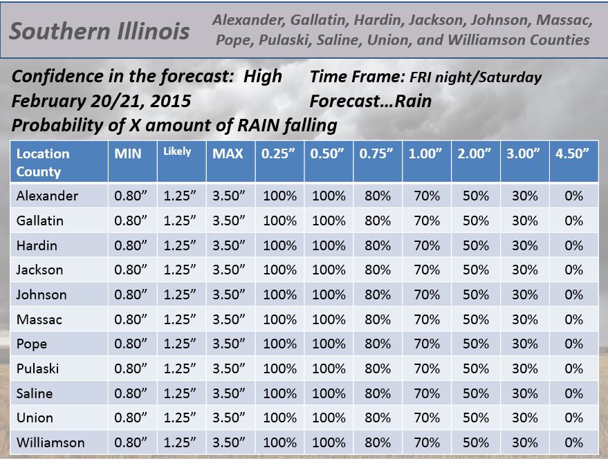
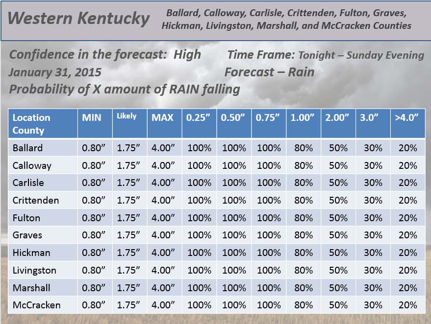
Here are my handmade rainfall probabilities (these are not computer generated)

We have a new sponsor! G&C Multi-Services out of Paducah, Kentucky. G & C Multi-Services is a service provider in Western Kentucky that provides industrial and commercial equipment fabrication, machine troubleshooting, repair and maintenance, and installation. They can custom fabricate steel, stainless, and aluminum products per customer specifications.
Visit their web-site here. Or click the ad below! They have a Facebook page and it can be viewed here.


Extremely slick roadways later today into tonight. Roads will become an ice skating rink once freezing rain develops. Any freezing rain on these cold road surfaces will be a travel nightmare.
Ice accumulation on trees could cause some issues later tonight. This will depend on what time the 32+ degree line crosses each county. It will first reach southeast Missouri and then more northeast into southern Illinois and western Kentucky. Once temperatures rise above 32 degrees then freezing rain will come to an end and plain old rain will fall.
Freezing rain may accumulate 0.10″-0.15″ in some areas. If the freezing line is slower than expected then 0.25″+ of freezing rain will be possible. The higher totals could cause problems. Again, everything will hinge on temperatures rising above freezing.
Monitor updates today – there will be several.
Flash flooding or flooded roadways on Saturday could be an issue. If heavy rain does develop then rapid rises in creeks can be expected. Also…storm drains are clogged in some areas by snow and ice. This is a concern, as well.
Check out our newest sponsors $5 meal! The DQ Grill and Chill (located across from Noble Park in Paducah, Kentucky) is the newest WeatherTalk Blog sponsor! A local business helping to sponsor the weather information that you have come to love so much.
They have a Facebook Page and I encourage you to check it out. DQ Grill and Chill on Facebook


The wild card tells you where the uncertainties are in the forecast
Wild card in this forecast – there are so many wild cards in this forecast, I don’t know where to start.
The timing of the freezing line reaching western Kentucky and southern Illinois. This is a big question mark. I am leaning towards the 10 pm to 3 am time frame. It will take longer over northern parts of the area and into southwest Indiana. Let’s hope that time frame is correct. We do not want the freezing rain to continue any longer than it has to.
Rainfall amounts on Saturday. Could there be some 3″ totals in the region? That is one wild card.
Will there be a few rumbles of thunder with this event? It is possible.

Can we expect severe thunderstorms over the next 24 to 48 hours? Remember that a severe thunderstorm is defined as a thunderstorm that produces 58 mph winds or higher, quarter size hail or larger, and/or a tornado.
Thunderstorm threat level is ONE Some thunder and lightning possible on Saturday. Maybe gusty winds if a thunderstorm does form. Most likely this would be over Kentucky and Tennessee.


Will I need to take action?
Yes – extremely dangerous road conditions this afternoon into tonight. Do not travel if you don’t have to. Freezing rain is going to cause roads to become like skating rinks.
Ice accumulations may cause some tree branches to fall. This is more likely if temperatures don’t rise above freezing as quickly as forecast. Monitor updates through today.
Locally heavy rain on Saturday could cause ponding of water on roads. Ditches may flood. Small stream may rise.

How much precipitation should we expect over the next few days?
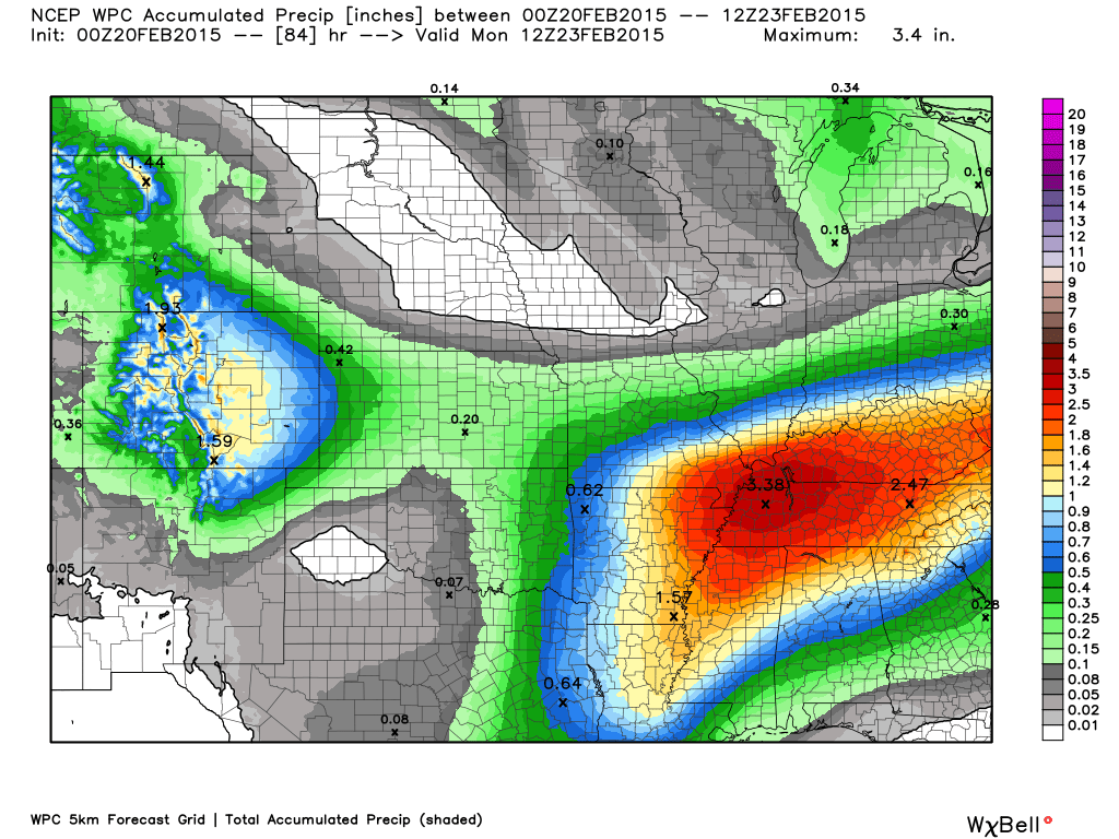
Heavy precipitation over the coming 48 hours. Expect widespread 1.00″-2.00″ amounts in the region.
Here are the latest numbers

All of our winter weather concerns surround today. That has been covered above.
Winter storm watches and warnings cover the area – click on your county for more details.


This section of the blog is speculative forecast information. Because it is past the range of what meteorologists can forecast accurately, it should be considered speculation. Anything past day 5 is considered a long range forecast.
Another couple of rounds of bitterly cold air Sunday into the end of next week. We are not finished with single digit readings.

Who do you trust for your weather information and who holds them accountable?
I have studied weather in our region since the late 1970’s. I have 37 years of experience in observing our regions weather patterns. My degree is in Broadcast Meteorology from Mississippi State University and an Associate of Science (AS). I am currently working on my Bachelor’s Degree in Geoscience. Just need to finish two Spanish classes!
I am a member of the American Meteorological Society. I am a NOAA Weather-Ready Nation Ambassador. And, I am the Meteorologist for McCracken County Emergency Management.
I own and operate the Southern Illinois Weather Observatory.
There is a lot of noise on the internet. A lot of weather maps are posted without explanation. Over time you should learn who to trust for your weather information.
My forecast philosophy is simple and straight forward.
- Communicate in simple terms
- To be as accurate as possible within a reasonable time frame before an event
- Interact with you on Twitter, Facebook, and the blog
- Minimize the “hype” that you might see on television or through other weather sources
- Push you towards utilizing wall-to-wall LOCAL TV coverage during severe weather events
I am a recipient of the Mark Trail Award, WPSD Six Who Make A Difference Award, Kentucky Colonel, and the Caesar J. Fiamma” Award from the American Red Cross. In 2009 I was presented with the Kentucky Office of Highway Safety Award. I was recognized by the Kentucky House of Representatives for my service to the State of Kentucky leading up to several winter storms and severe weather outbreaks.
If you click on the image below you can read the Kentucky House of Representatives Resolution.

I am also President of the Shadow Angel Foundation which serves portions of western Kentucky and southern Illinois.

We have regional radars and local city radars – if a radar does not seem to be updating then try another one. Occasional browsers need their cache cleared. You may also try restarting your browser. That usually fixes the problem. Occasionally we do have a radar go down. That is why I have duplicates. Thus, if one fails then try another one.
If you have any problems then please send me an email beaudodson@usawx.com
WEATHER RADAR PAGE – Click here —
We also have a new national interactive radar – you can view that radar by clicking here.
Local interactive city radars include St Louis, Mt Vernon, Evansville, Poplar Bluff, Cape Girardeau, Marion, Paducah, Hopkinsville, Memphis, Nashville, Dyersburg, and all of eastern Kentucky – these are interactive radars. Local city radars – click here
NOTE: Occasionally you will see ground clutter on the radar (these are false echoes). Normally they show up close to the radar sites – including Paducah.

Regional Radar – Click on radar to take you our full radar page.

Regional Radar

Live Lightning Data – zoom and pan: Click here
Live Lightning Data with sound (click the sound button on the left side of the page): Click here
![]()
Current WARNINGS (a warning means take action now). Click on your county to drill down to the latest warning information. Keep in mind that there can be a 2-3 minute delay in the updated warning information.
I strongly encourage you to use a NOAA Weather Radio or warning cell phone app for the most up to date warning information. Nothing is faster than a NOAA weather radio.


Color shaded counties are under some type of watch, warning, advisory, or special weather statement. Click your county to view the latest information.

Missouri Warnings

Illinois Warnings

Kentucky Warnings

Please visit your local National Weather Service Office by clicking here. The National Weather Service Office, for our region, is located in Paducah, Kentucky. They have a lot of maps and information on their site. Local people…local forecasters who care about our region.


Here is the official 6-10 day and 8-14 day temperature and precipitation outlook. Check the date stamp at the top of each image (so you understand the time frame).
The forecast maps below are issued by the Weather Prediction Center (NOAA).


The latest 8-14 day temperature and precipitation outlook. Note the dates are at the top of the image. These maps DO NOT tell you how high or low temperatures or precipitation will be. They simply give you the probability as to whether temperatures or precipitation will be above or below normal.


Many of my graphics are from www.weatherbell.com – a great resource for weather data, model data, and more


This blog was inspired by ABC 33/40’s Alabama Weather Blog – view their blog
Current tower cam view from the Weather Observatory- Click here for all cameras.

Southern Illinois Weather Observatory

The Weather Observatory

Southern Illinois Weather Observatory
WSIL TV 3 has a number of tower cameras. Click here for their tower camera page & Illinois Road Conditions

Marion, Illinois
WPSD TV 6 has a number of tower cameras. Click here for their tower camera page & Kentucky Road Conditions & Kentucky Highway and Interstate Cameras

Downtown Paducah, Kentucky
Benton, Kentucky Tower Camera – Click here for full view

Benton, Kentucky

I24 Paducah, Kentucky

I24 Mile Point 9 – Paducah, KY

I24 – Mile Point 3 Paducah, Kentucky

You can sign up for my AWARE email by clicking here I typically send out AWARE emails before severe weather, winter storms, or other active weather situations. I do not email watches or warnings. The emails are a basic “heads up” concerning incoming weather conditions.