We have our first sponsor for the blog. Milner and Orr Funeral Home and Cremation Services located in Paducah, Kentucky and three other western Kentucky towns – at Milner and Orr they believe in families helping families.
![]()

This forecast update covers far southern Illinois, far southeast Missouri, and far western Kentucky. See the coverage map on the right side of the blog.
Remember that weather evolves. Check back frequently for updates, especially during active weather.
Saturday – All freezing rain ending. Rain continuing but ending from north to south during the afternoon. Heavy rain likely at times and some thunderstorms. Flooding could occur in some locations. Temperatures will mostly remain in the 30’s. Temperatures will start to fall again this afternoon. Any moisture left on roadways could freeze again tonight. Keep this in mind. NOT calling for precipitation falling tonight and freezing – just saying if there is moisture left on the roadways. Winds becoming north at 10-15 mph. My confidence in this part of the forecast verifying is medium
WEATHER RADAR PAGE – Click here —
Saturday night – Cloudy. A snow shower possible. Black ice possible if moisture remains on roadways (that is just moisture that refreezes – black ice is not something that falls from the sky) Colder with lows in the 15 to 24 degree range. North winds at 10 mph. My confidence in this part of the forecast verifying is medium
Sunday – Cloudy. A chance for a snow flurry. Colder. Temperatures falling into the teens during the afternoon. North winds at 10-15 mph. My confidence in this part of the forecast verifying is medium
Sunday night – Cloudy. Very cold. Lows near -5 north around Mt Vernon and single digits over most of southern Illinois. North winds light. Perhaps in the 6 to 12 range for western Kentucky. My confidence in this part of the forecast verifying is high
Monday – Cloudy. Cold. Highs may not recover much – single digit perhaps in some counties. Some data actually shows temperatures falling even lower during the day on Monday. I will monitor this. Light north winds. My confidence in this part of the forecast verifying is medium

Current Temperatures Around The Local Area


Watches and warnings – click your county for the latest advisories or warnings

We have a new sponsor! G&C Multi-Services out of Paducah, Kentucky. G & C Multi-Services is a service provider in Western Kentucky that provides industrial and commercial equipment fabrication, machine troubleshooting, repair and maintenance, and installation. They can custom fabricate steel, stainless, and aluminum products per customer specifications.
Visit their web-site here. Or click the ad below! They have a Facebook page and it can be viewed here.


An explanation of what is happening in the atmosphere over the coming days…
Oh, the weatherman has been busy busy. What a week! Snowstorm to record cold to ice storm to heavy rain and even thunder-ice last night.
Go figure!
This has been a very complicated weather system. Was very worried about being off by 1-3 degrees in my temperature forecast yesterday. The colder data verified. Just another reminder as to why it is important to check back often for the latest information.
It has been a long 48 hours – I will cover the upcoming 24 hours as the focus for this forecast update.
Please, be sure and check out the blog sponsors on this page. They are doing a great job of keeping the weather data flowing.
THANK YOU to everyone who has made donations over the past 2 days. Amazing number of you have given. It is so appreciated.
Okay…
Ice feel overnight across the region. Ice accumulations of 0.10″ to 0.40″ were common place. The heaviest ice totals were over southeast Missouri and southern Illinois. Scattered broken tree branches and power outages were reported in the region.
Temperatures during the wee hours of the morning were slow to rise. Very slow. As of this writing all of western Kentucky and southern Illinois were still below freezing. But, I am sure by sunrise that most areas will be above freezing over western Kentucky and parts of far southern Illinois.
The next concern will be rainfall today. The rain will end from north to south. A band of rain will continue into the afternoon hours over far southern Illinois and much of Kentucky. This band of rain could produce another 0.50″ to 1.00″ of rainfall. More towards the Kentucky and Tennessee border.
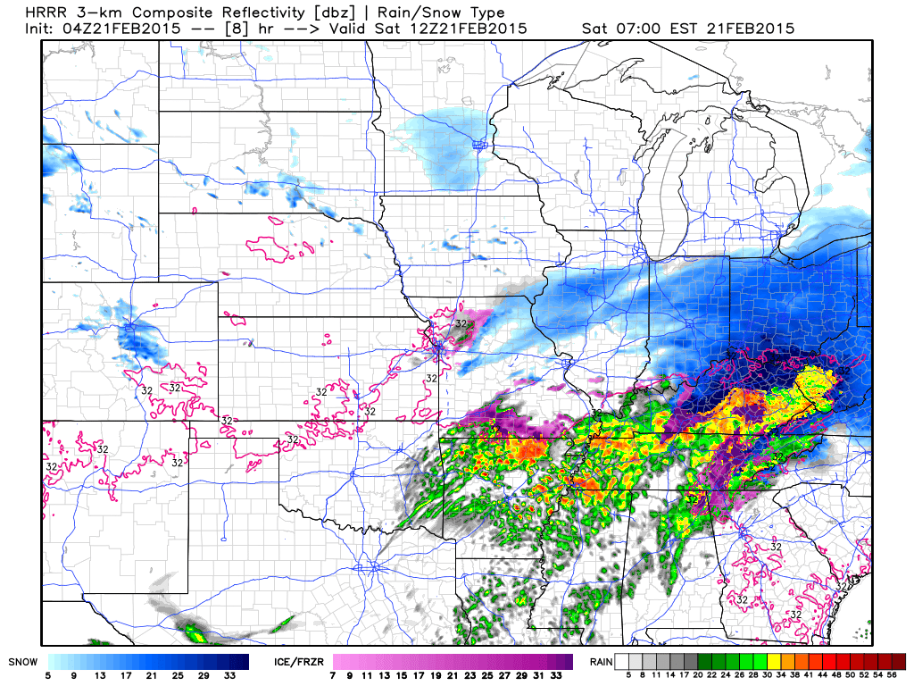
Future-cast radar for today shows it nicely.
6 AM Future-cast radar – see round 3 coming? BE VERY thankful that most of us are above freezing.
Images are from www.weatherbell.com
Future-cast radar for around 8 AM
You can see precipitation pushing back into our area. Locally heavy rain and even thunderstorms. The purple area represents possible ice.

Future-cast radar for around 11 am – locally heavy rain over western Kentucky

Future-cast radar for around 1 pm this afternoon – you can see the rain shifting south and southeast
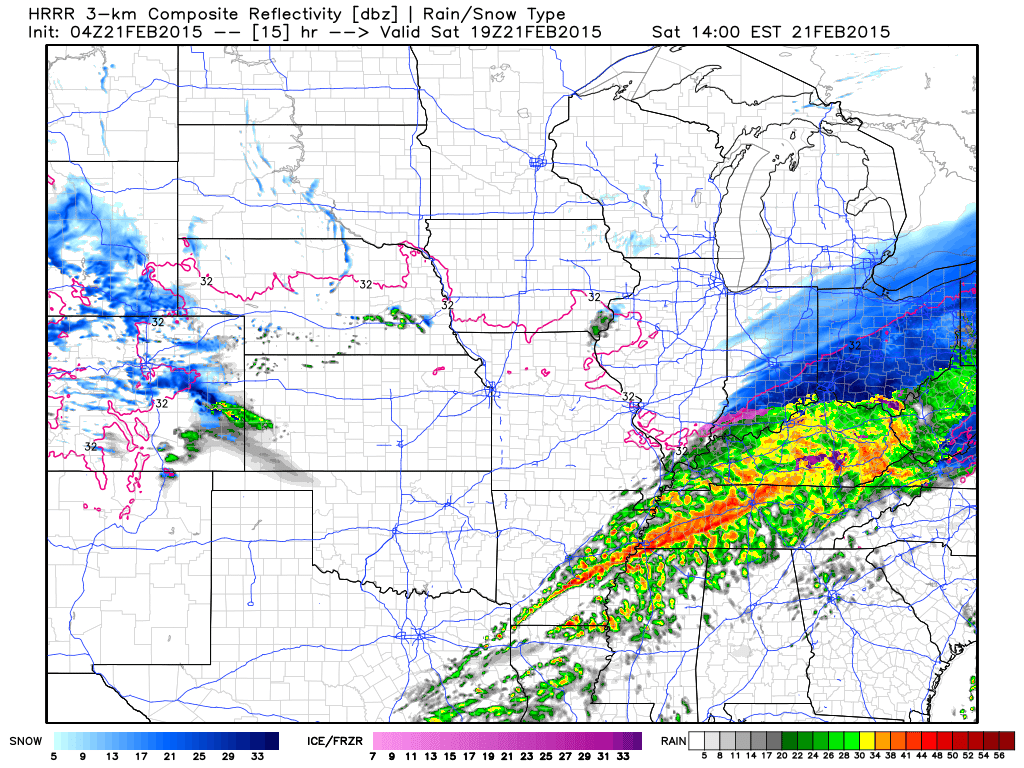
Thunderstorms likely at times. Locally heavy rain will enhance rainfall totals.
This could be enough to cause some ponding of water on roadways and flooding in spots. Streams will also be on the rise.
Monitor any warnings that the National Weather Service might issue.
Rain will end later this afternoon. Colder air will then filter into the region. By tonight we will be back down into the middle teens to lower 20’s.
If there is any moisture left on the roadways then it could refreeze.
VERY cold air arrives for Monday morning – likely back below zero over northern parts of southern Illinois and single digits over much of southern Illinois. Single digits to lower teens for western Kentucky. Did you think winter was over yet?
The rest of the week will be cold to bitter cold, as well.
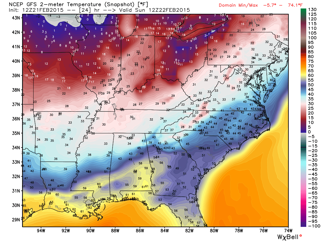
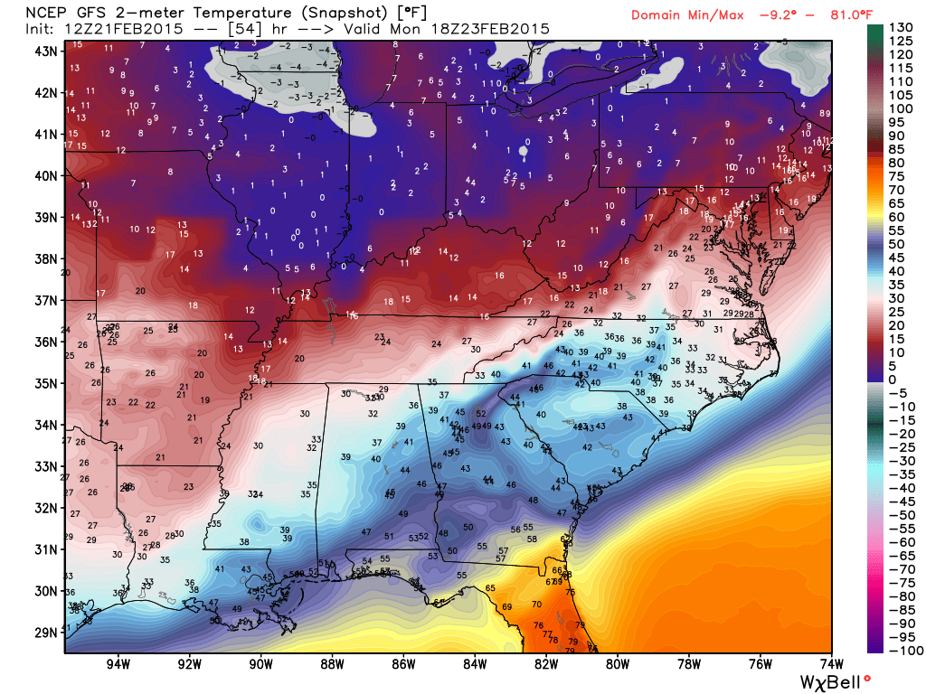
Let’s look at some temperature maps from the GFS mode – images from www.weatherbell.com
Click image for full view size
6 AM to 7 AM on Sunday morning
Sunday afternoon temperatures – they have actually fallen

Monday morning bitter cold

Monday afternoon – very cold
How many degrees below normal will temperatures be on Monday? These are not TEMPERATURES – these numbers represent how many degrees above or below the norms we will be.

I am watching additional storm systems towards next weekend and into the following week. Too soon to know if any of them will verify.
The southern jet stream has suddenly become very active. Active it will remain.

Morning slick roads. It should be melting over much of far southern Illinois and western Kentucky – but it might take some time in some places.
Moderate to heavy rain today. We could see some ponding of water on roadways and even some stream flooding. Monitor NWS watches and warnings
Check out our newest sponsors $5 meal! The DQ Grill and Chill (located across from Noble Park in Paducah, Kentucky) is the newest WeatherTalk Blog sponsor! A local business helping to sponsor the weather information that you have come to love so much.
They have a Facebook Page and I encourage you to check it out. DQ Grill and Chill on Facebook


The wild card tells you where the uncertainties are in the forecast
Wild card in this forecast – how much additional rain falls today. Data indicates additional rain this morning. It should taper off this afternoon. Heaviest rains should be over southern and southeast half of the region – especially Kentucky/Tennessee. Perhaps far southern Illinois. We will see how quickly we can push this line southward. We don’t need a lot of rain on top of this mess.

Can we expect severe thunderstorms over the next 24 to 48 hours? Remember that a severe thunderstorm is defined as a thunderstorm that produces 58 mph winds or higher, quarter size hail or larger, and/or a tornado.
Thunderstorm threat level is ONE – some thunderstorms are possible


Will I need to take action?
Yes – roads may still be slick in some areas this morning.
Some flooding will be possible today. Monitor any NWS watches and warnings.
Cold temperatures tonight could refreeze moisture on roadways. Keep this in mind.

How much precipitation should we expect over the next few days?
Rain will continue today with additional periods of heavy rain – especially over far southern Illinois and western Kentucky – northwest Tennessee. Some flooding possible in spots. Not the best situation.
Rainfall forecast
Most of today’s rainfall (from 7 am to 2 pm) will be over far southern IL and western KY. I am thinking another 0.35″ for northern and central parts of southern Illinois and another 0.50″ to 1.00″ or so for far southern Illinois. Another 0.75″-1.25″ for western Kentucky. If training of precipitation occurs then locally heavier totals likely.
WEATHER RADAR PAGE – Click here —

This section of the blog is speculative forecast information. Because it is past the range of what meteorologists can forecast accurately, it should be considered speculation. Anything past day 5 is considered a long range forecast.
It has been a VERY long 8 days of weather. I have not spent much time on the long range because of the current ongoing weather event.
Next week will be cold. Some days may be back into the single digits.
I continue to forecast a very active southern jet stream. Remember over the last two weeks I said the end of February would be crazy
Multiple winter storms may move into our region or south of us over the coming 1 1/2 week. Stay tuned for updates
I believe most of this upcoming week will be calm for us locally – mostly dry. Maybe some snow showers. That is Monday through Thursday. Beyond that I am going to have to monitor for more winter weather. Stay tuned.

Who do you trust for your weather information and who holds them accountable?
I have studied weather in our region since the late 1970’s. I have 37 years of experience in observing our regions weather patterns. My degree is in Broadcast Meteorology from Mississippi State University and an Associate of Science (AS). I am currently working on my Bachelor’s Degree in Geoscience. Just need to finish two Spanish classes!
I am a member of the American Meteorological Society. I am a NOAA Weather-Ready Nation Ambassador. And, I am the Meteorologist for McCracken County Emergency Management.
I own and operate the Southern Illinois Weather Observatory.
There is a lot of noise on the internet. A lot of weather maps are posted without explanation. Over time you should learn who to trust for your weather information.
My forecast philosophy is simple and straight forward.
- Communicate in simple terms
- To be as accurate as possible within a reasonable time frame before an event
- Interact with you on Twitter, Facebook, and the blog
- Minimize the “hype” that you might see on television or through other weather sources
- Push you towards utilizing wall-to-wall LOCAL TV coverage during severe weather events
I am a recipient of the Mark Trail Award, WPSD Six Who Make A Difference Award, Kentucky Colonel, and the Caesar J. Fiamma” Award from the American Red Cross. In 2009 I was presented with the Kentucky Office of Highway Safety Award. I was recognized by the Kentucky House of Representatives for my service to the State of Kentucky leading up to several winter storms and severe weather outbreaks.
If you click on the image below you can read the Kentucky House of Representatives Resolution.

I am also President of the Shadow Angel Foundation which serves portions of western Kentucky and southern Illinois.

We have regional radars and local city radars – if a radar does not seem to be updating then try another one. Occasional browsers need their cache cleared. You may also try restarting your browser. That usually fixes the problem. Occasionally we do have a radar go down. That is why I have duplicates. Thus, if one fails then try another one.
If you have any problems then please send me an email beaudodson@usawx.com
WEATHER RADAR PAGE – Click here —
We also have a new national interactive radar – you can view that radar by clicking here.
Local interactive city radars include St Louis, Mt Vernon, Evansville, Poplar Bluff, Cape Girardeau, Marion, Paducah, Hopkinsville, Memphis, Nashville, Dyersburg, and all of eastern Kentucky – these are interactive radars. Local city radars – click here
NOTE: Occasionally you will see ground clutter on the radar (these are false echoes). Normally they show up close to the radar sites – including Paducah.

Regional Radar – Click on radar to take you our full radar page.


Regional Radar

Live Lightning Data – zoom and pan: Click here
Live Lightning Data with sound (click the sound button on the left side of the page): Click here
![]()
Current WARNINGS (a warning means take action now). Click on your county to drill down to the latest warning information. Keep in mind that there can be a 2-3 minute delay in the updated warning information.
I strongly encourage you to use a NOAA Weather Radio or warning cell phone app for the most up to date warning information. Nothing is faster than a NOAA weather radio.


Color shaded counties are under some type of watch, warning, advisory, or special weather statement. Click your county to view the latest information.

Missouri Warnings

Illinois Warnings

Kentucky Warnings

Please visit your local National Weather Service Office by clicking here. The National Weather Service Office, for our region, is located in Paducah, Kentucky. They have a lot of maps and information on their site. Local people…local forecasters who care about our region.


Here is the official 6-10 day and 8-14 day temperature and precipitation outlook. Check the date stamp at the top of each image (so you understand the time frame).
The forecast maps below are issued by the Weather Prediction Center (NOAA).


The latest 8-14 day temperature and precipitation outlook. Note the dates are at the top of the image. These maps DO NOT tell you how high or low temperatures or precipitation will be. They simply give you the probability as to whether temperatures or precipitation will be above or below normal.


Many of my graphics are from www.weatherbell.com – a great resource for weather data, model data, and more


This blog was inspired by ABC 33/40’s Alabama Weather Blog – view their blog
Current tower cam view from the Weather Observatory- Click here for all cameras.

Southern Illinois Weather Observatory

The Weather Observatory

Southern Illinois Weather Observatory
WSIL TV 3 has a number of tower cameras. Click here for their tower camera page & Illinois Road Conditions

Marion, Illinois
WPSD TV 6 has a number of tower cameras. Click here for their tower camera page & Kentucky Road Conditions & Kentucky Highway and Interstate Cameras

Downtown Paducah, Kentucky
Benton, Kentucky Tower Camera – Click here for full view

Benton, Kentucky

I24 Paducah, Kentucky

I24 Mile Point 9 – Paducah, KY

I24 – Mile Point 3 Paducah, Kentucky

You can sign up for my AWARE email by clicking here I typically send out AWARE emails before severe weather, winter storms, or other active weather situations. I do not email watches or warnings. The emails are a basic “heads up” concerning incoming weather conditions.