We have some great sponsors for the Weather Talk Blog. Please let our sponsors know that you appreciate their support for the Weather Talk Blog.
Milner and Orr Funeral Home and Cremation Services located in Paducah, Kentucky and three other western Kentucky towns – at Milner and Orr they believe in families helping families. You can find Milner and Orr on Facebook, as well.
![]()
.

For all of your families eye care needs. Visit their web-site here. Or, you can also visit their Facebook page.
.

Best at Enabling Body Shop Profitability since 1996. Located In Paducah Kentucky and Evansville Indiana; serving all customers in between. They provide Customer Service, along with all the tools necessary for body shops to remain educated and competitive. Click the logo above for their main web-site. You can find McClintock Preferred Finishes on Facebook, as well
.

Duck/goose decoys? Game calls? Optics? We have you covered! Click the logo above or visit Final Flight on Facebook, as well.
.
I have launched the new weather texting service! I could use your help. Be sure and sign up and fully support all of the weather data you see each day.
This is a monthly subscription service. Supporting this helps support everything else. The cost is $3 a month for one phone, $5 a month for three phones, and $10 a month for seven phones.
For more information visit BeauDodsonWeather.com
Or directly sign up at Weathertalk.com


This forecast update covers far southern Illinois, far southeast Missouri, and far western Kentucky. See the coverage map on the right side of the blog.
Remember that weather evolves. Check back frequently for updates, especially during active weather.

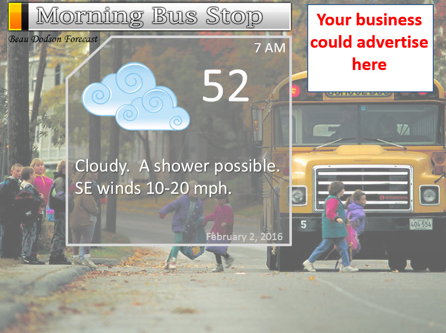
Monday night – Showers possible. Thunderstorms possible. Some storms could produce locally heavy rain. Windy. Mild.
Temperatures: Lows from 46 to 52 degrees
Winds: Southwest winds at 10-20 mph. Gusty at times, especially towards Tuesday morning.
What is the chance for precipitation? 30% after midnight
Coverage of precipitation? Scattered
My confidence in this part of the forecast verifying is High
Should I be concerned about snow or ice? No
Should I cancel my outdoor plans? No, but some showers are possible. Monitor updates.
Is severe weather expected? No
What impact is expected? Wet roadways and gusty winds. Lightning possible after midnight.
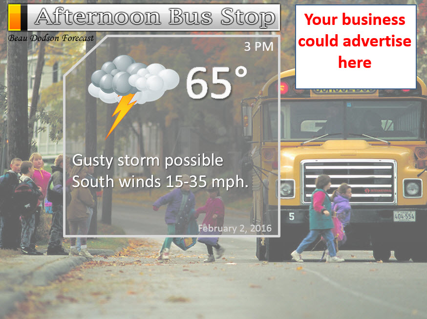
Tuesday – Windy. Showers and thunderstorms likely. Locally heavy rain. Very mild ahead of the cold front. A few storms could be quite strong.
Temperatures: Highs will range 62 to 68 degree range.
Winds: Southeast winds at 15-35 mph. Gusts above 35 mph possible on Tuesday morning. Strong winds possible with thunderstorms. Winds turning southwest late in the day.
What is the chance for precipitation? 70%
Coverage of precipitation? Scattered to perhaps widespread.
My confidence in this part of the forecast verifying is High
Should I be concerned about snow or ice? No
Should I cancel my outdoor plans? Have another plan if you have outdoor activities.
Is severe weather expected? Severe weather can not be ruled out. Monitor updates.
What impact is expected? Gusty winds, heavy rain, lightning, and perhaps a few storms reaching severe levels. Monitor updates.
Tuesday night – Showers and thunderstorms ending. Turning colder. Breezy.
Temperatures: Lows from 38 to 42 degrees
Winds: West/southwest winds at 8-16 mph. Gusty.
What is the chance for precipitation? 40% early and then 10% after midnight.
Coverage of precipitation? Scattered early. Ending from west to east.
My confidence in this part of the forecast verifying is Medium
Should I be concerned about snow or ice? No
Should I cancel my outdoor plans? No, but some evening showers/storms still possible as the system exits our region.
Is severe weather expected? Believe the severe weather risk will come to an end on Tuesday evening. Eastern counties will need to see how quick this system exits. That would include the Pennyrile area of western Kentucky.
What impact is expected? Wet roadways, gusty winds, severe weather threat ending from west to east.
Questions? Email me at beaudodson@usawx.com
Wednesday – Partly cloudy and colder.
Temperatures: Highs will range 36 to 42 degrees.
Winds: West winds at 6-12 mph. Gusts to 18 mph.
What is the chance for precipitation? 0%
Coverage of precipitation? None
My confidence in this part of the forecast verifying is High
Should I be concerned about snow or ice? No
Should I cancel my outdoor plans? No
Is severe weather expected? No
What impact is expected? None
Wednesday night – Mostly clear and colder.
Temperatures: Lows from 25-30 degrees
Winds: West and northwest winds at 4-8 mph.
What is the chance for precipitation? 0%
Coverage of precipitation? None
My confidence in this part of the forecast verifying is High
Should I be concerned about snow or ice? No
Should I cancel my outdoor plans? No
Is severe weather expected? No
What impact is expected? None
Thursday – Mostly sunny and cool.
Temperatures: Highs will range 40-45 degrees.
Winds: Northwest winds at 5 mph becoming southwest winds during the afternoon at 4-8 mph.
What is the chance for precipitation? 0%
Coverage of precipitation? None
My confidence in this part of the forecast verifying is High
Should I be concerned about snow or ice? No
Should I cancel my outdoor plans? No
Is severe weather expected? No
What impact is expected? None


Don’t forget to check out the Southern Illinois Weather Observatory web-site for weather maps, tower cams, scanner feeds, radars, and much more! Click here

An explanation of what is happening in the atmosphere over the coming days…
Highlights
1. Gusty winds on Tuesday into Tuesday evening. Some wind gusts above 40 mph possible.
2. Thunderstorms possible Tuesday morning into Tuesday afternoon. A few storms could be quite intense.
3. Much colder by Wednesday into the weekend. Say goodbye to the 60s.
The big weather story continues to be our storm system on Tuesday. We have been tracking this for more than ten days now! And, one thing has remained consistent, we will be on the warm side of the low. This won’t be a snow producer for our region. You will have to travel into Kansas, Nebraska, and Iowa to experience heavy snow and blizzard conditions.
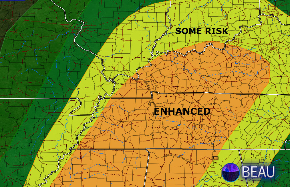
We will have to deal with showers and thunderstorms in our local area. Some of the storms could be intense. We are outlined, by the Storm Prediction Center, for a few severe thunderstorms. The higher probability risk zone covers southeast Illinois, western Kentucky, and western Tennessee. Our western counties may not have to deal with severe weather. That would include Poplar Bluff, Missouri to Farmington, Missouri. But, areas along the Mississippi River eastward will have at least some chance for heavy thunderstorms.
The SPC issued this map below. Keep in mind, they change these maps around with every update. Normally there is a shift east or west. So, expect adjustments. I don’t like to show these maps. People get too caught up in the colors. The atmosphere doesn’t know a line made by man. If your county is sliced in half by one color or another then please don’t think that carries too much weight. It does not. Again, these are man-made lines.
The orange is a greater risk zone than the yellow. The yellow is a greater risk zone than the dark green. The green on the very far left is the least amount of risk.
Wind fields aloft will be very strong with this system. And, if thunderstorms can tap into those winds, some damaging wind gusts will be possible in our area. I would be surprised if there were not a few reports of damaging winds with this system. And, there is even a small risk for short lived tornadoes.
This is not a classic supercell tornado setup. This is more along the lines of what we call QLCS tornadoes. Those are short lived tornadoes that form in squall lines. Bow segments (areas where thunderstorms bow outward) can produce them or little inflow notch areas along the line. Very common in our area. Often times we may not even know they have occurred. I have seen some of them last a few hundreds yards and be less than 20′ in width.
Bottom line for Tuesday is that I suspect we will see a severe thunderstorm or tornado watch issued for parts of the area. And some warnings will be possible. Nothing out of the usual for a system like this.
As always, monitor updates on Tuesday. If a warning is issued then seek shelter until the storm has moved passed your local area. I will be utilizing the texting service on Tuesday. If you have subscribed to the severe weather alerts then you can expect some text messages.
Colder air returns on Wednesday. High temperatures will remain in the upper 30s and lower 40s.
Dry into Friday.
Let’s look at the timing of the system on Tuesday. Keep in mind this is a rough estimate.
The EC guidance brings the line through about 3-5 hours faster than the NAM and GFS.
That would mean southern IL and western KY could have storms between 9 am and 1 pm. If the slower models are correct then it will be more like 11 am to 3 pm.
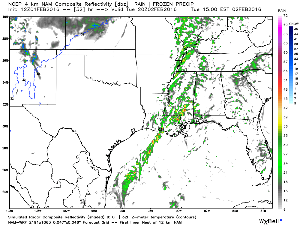
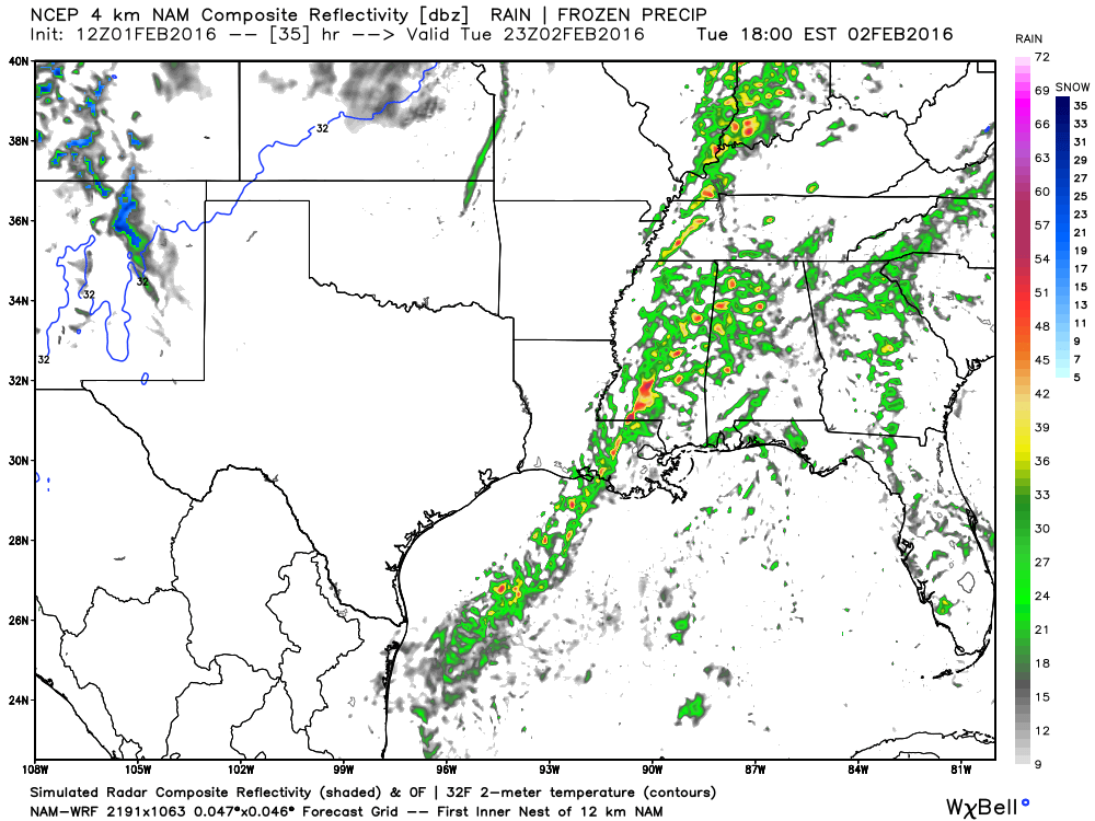
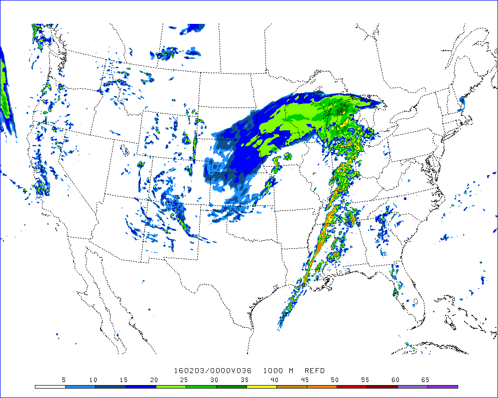
This is the future-cast radar for Tuesday around 1 pm to 3 pm. You can see a broken band of showers and some gusty thunderstorms from Illinois down into the Missouri Bootheel. The thinking is that this will be the beginning of the heaviest band of storms that will form moving forward.
Some data develops this activity a bit sooner. Keep that in mind. The main idea is that it will intensify as it moves further east.
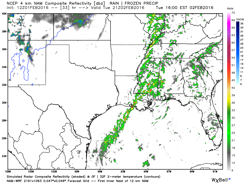
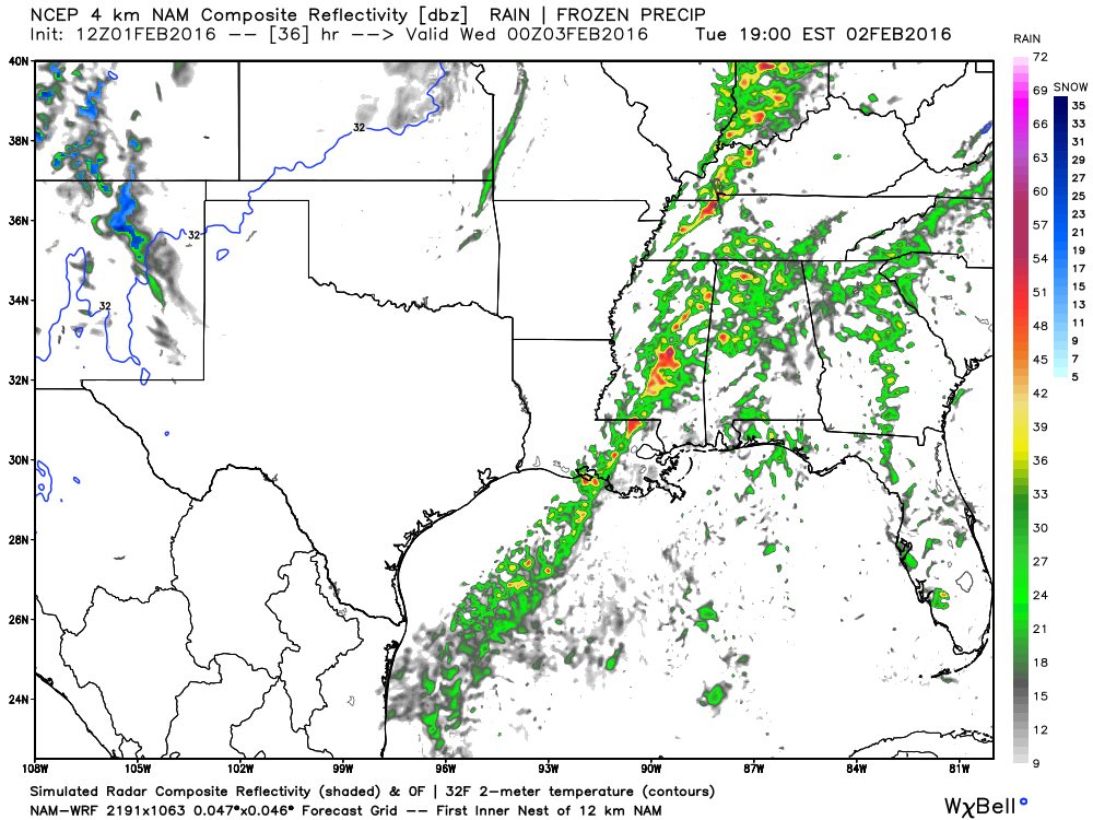
This is the 2 pm to 3 pm time frame. You can see the band shifting eastward. And, those yellow and orange areas represent heavier thunderstorms. This won’t be exact, of course. It is simply model guidance. But, you get the general idea.
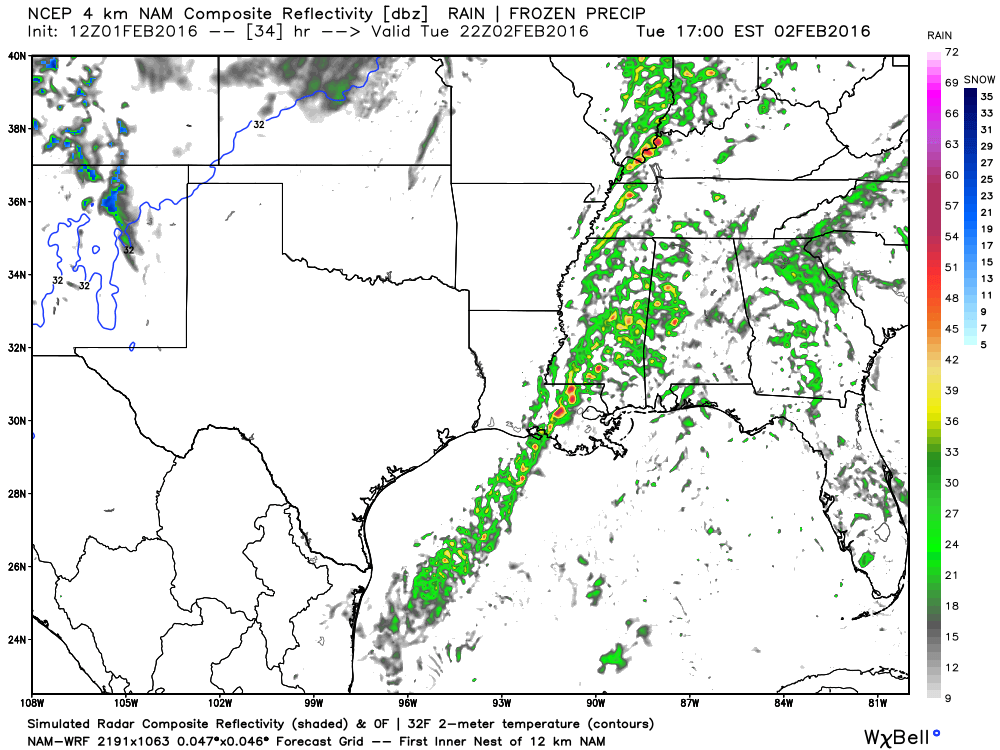
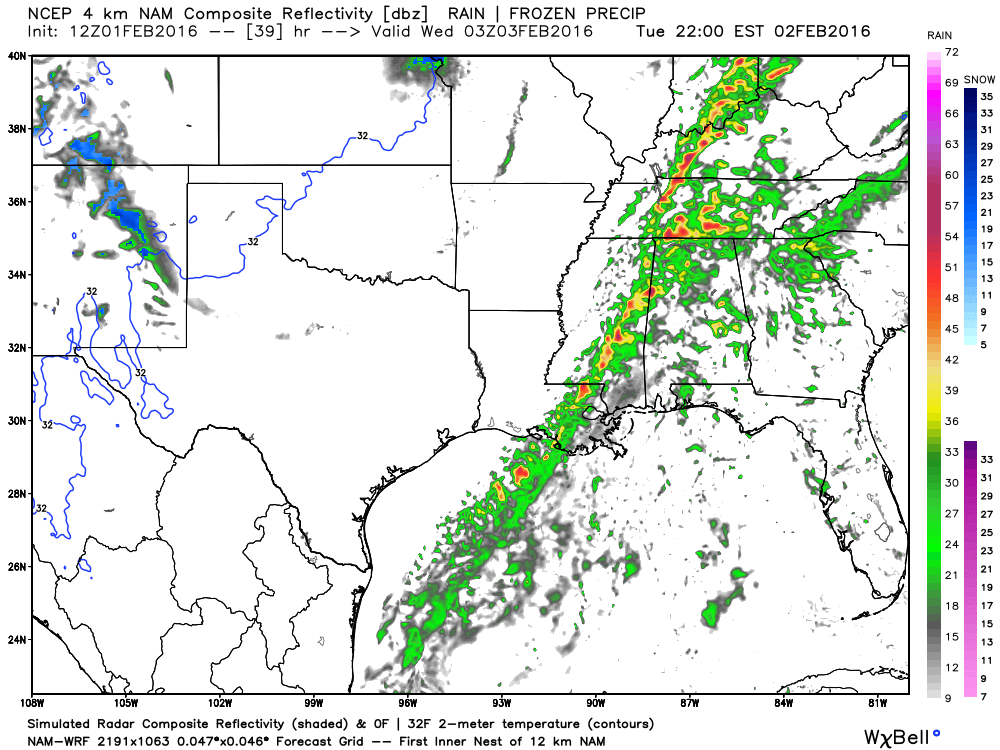
This is the 4 pm hour. Storms are increased in intensity and are moving east/northeast. Zipping along.
This is the 5 pm hour. Storms continue to move east.
And, this is the 6 pm hour.
This is the 8-9 pm hour. Intense line of gusty thunderstorms pushing out of our local area.
Here is another model from the SPC. I like this one. It typically does quite well. This is for 5 pm. It shows the storms over western KY into western TN
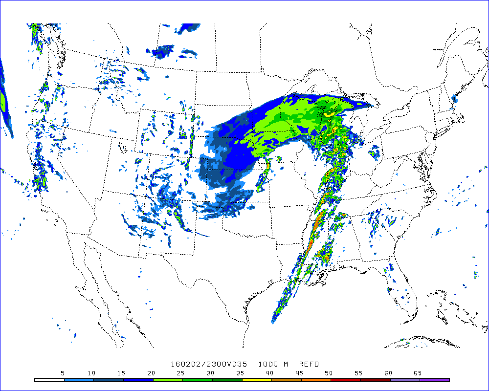
And, it is moving eastward through the evening hours.

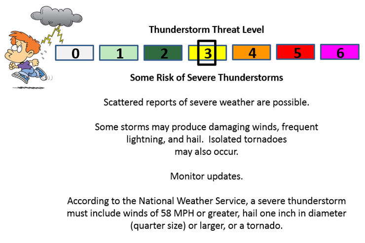
Can we expect severe thunderstorms over the next 24 to 48 hours? Remember that a severe thunderstorm is defined as a thunderstorm that produces 58 mph winds or higher, quarter size hail or larger, and/or a tornado.
The thunderstorm threat level will be a Three on Tuesday. Mainly over southern Illinois, western Kentucky, and western Tennessee. Lesser risk over southeast Missouri. Or so it would appear at this time.
A few storms could produce damaging wind gusts on Tuesday. Small hail will also be possible. There is a risk for a few short lived tornadoes if the squall line matures enough.

No winter weather anticipated.

Tuesday – No snow or ice anticipated
Wednesday – Small chance for flurries
Thursday – No snow or ice anticipated
Friday – No snow or ice anticipated
Saturday – No significant snow or ice anticipated.

No major adjustments in this forecast package update.

Gusty winds will be a concern on Tuesday. Winds gusting in the 35-40 mph range will be possible as a cold front passes through the region during the morning and afternoon hours.
A few thunderstorms could produce winds in excess of 55 mph on Tuesday. A line of storms will push through the region. Best chances for the strongest storms will be over southeast Illinois and western Kentucky/western Tennessee. There is a small risk for short lived tornadoes, as well.

Yes. Monitor updated watches and warnings on Tuesday. A few may be issued for heavy thunderstorms. Damaging wind being the main concern.

The wild card will be severe weather chances on Tuesday. A few storms could become quite strong with high winds. Small brief tornado risk.

How much precipitation should we expect over the next few days?
Showers and thunderstorms will be possible late Monday night into Tuesday. Some of the storms on Tuesday could be on the heavy side.
Broad-brushed rainfall totals on Tuesday. The eastern half of the region should experience more than the western half. Not much has chanced in that part of the forecast. Totals of 0.25″-0.50″ with locally heavier amounts possible.
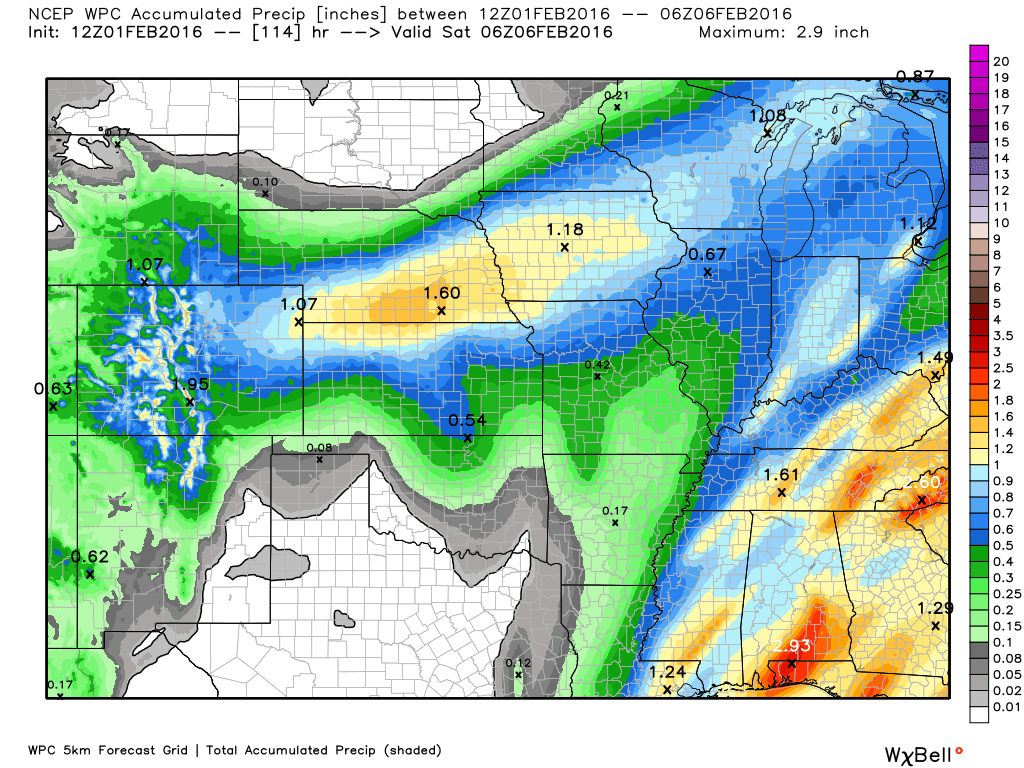

Here is the official 6-10 day and 8-14 day temperature and precipitation outlook. Check the date stamp at the top of each image (so you understand the time frame).
The forecast maps below are issued by the Weather Prediction Center (NOAA).


The latest 8-14 day temperature and precipitation outlook. Note the dates are at the top of the image. These maps DO NOT tell you how high or low temperatures or precipitation will be. They simply give you the probability as to whether temperatures or precipitation will be above or below normal.


Here are the current river stage forecasts. You can click your state and then the dot for your location. It will bring up the full forecast and hydrograph.
Click Here For River Stage Forecasts…

Who do you trust for your weather information and who holds them accountable?
I have studied weather in our region since the late 1970’s. I have 37 years of experience in observing our regions weather patterns. My degree is in Broadcast Meteorology from Mississippi State University and an Associate of Science (AS). I am currently working on my Bachelor’s Degree in Geoscience.
My resume includes:
Member of the American Meteorological Society.
NOAA Weather-Ready Nation Ambassador.
Meteorologist for McCracken County Emergency Management. I served from 2005 through 2015.
I own and operate the Southern Illinois Weather Observatory.
Recipient of the Mark Trail Award, WPSD Six Who Make A Difference Award, Kentucky Colonel, and the Caesar J. Fiamma” Award from the American Red Cross.
In 2009 I was presented with the Kentucky Office of Highway Safety Award.
Recognized by the Kentucky House of Representatives for my service to the State of Kentucky leading up to several winter storms and severe weather outbreaks.
I am also President of the Shadow Angel Foundation which serves portions of western Kentucky and southern Illinois.
There is a lot of noise on the internet. A lot of weather maps are posted without explanation. Over time you should learn who to trust for your weather information.
My forecast philosophy is simple and straight forward.
- Communicate in simple terms
- To be as accurate as possible within a reasonable time frame before an event
- Interact with you on Twitter, Facebook, and the blog
- Minimize the “hype” that you might see on television or through other weather sources
- Push you towards utilizing wall-to-wall LOCAL TV coverage during severe weather events
I am a recipient of the Mark Trail Award, WPSD Six Who Make A Difference Award, Kentucky Colonel, and the Caesar J. Fiamma” Award from the American Red Cross. In 2009 I was presented with the Kentucky Office of Highway Safety Award. I was recognized by the Kentucky House of Representatives for my service to the State of Kentucky leading up to several winter storms and severe weather outbreaks.
If you click on the image below you can read the Kentucky House of Representatives Resolution.

Many of my graphics are from www.weatherbell.com – a great resource for weather data, model data, and more


You can sign up for my AWARE email by clicking here I typically send out AWARE emails before severe weather, winter storms, or other active weather situations. I do not email watches or warnings. The emails are a basic “heads up” concerning incoming weather conditions.