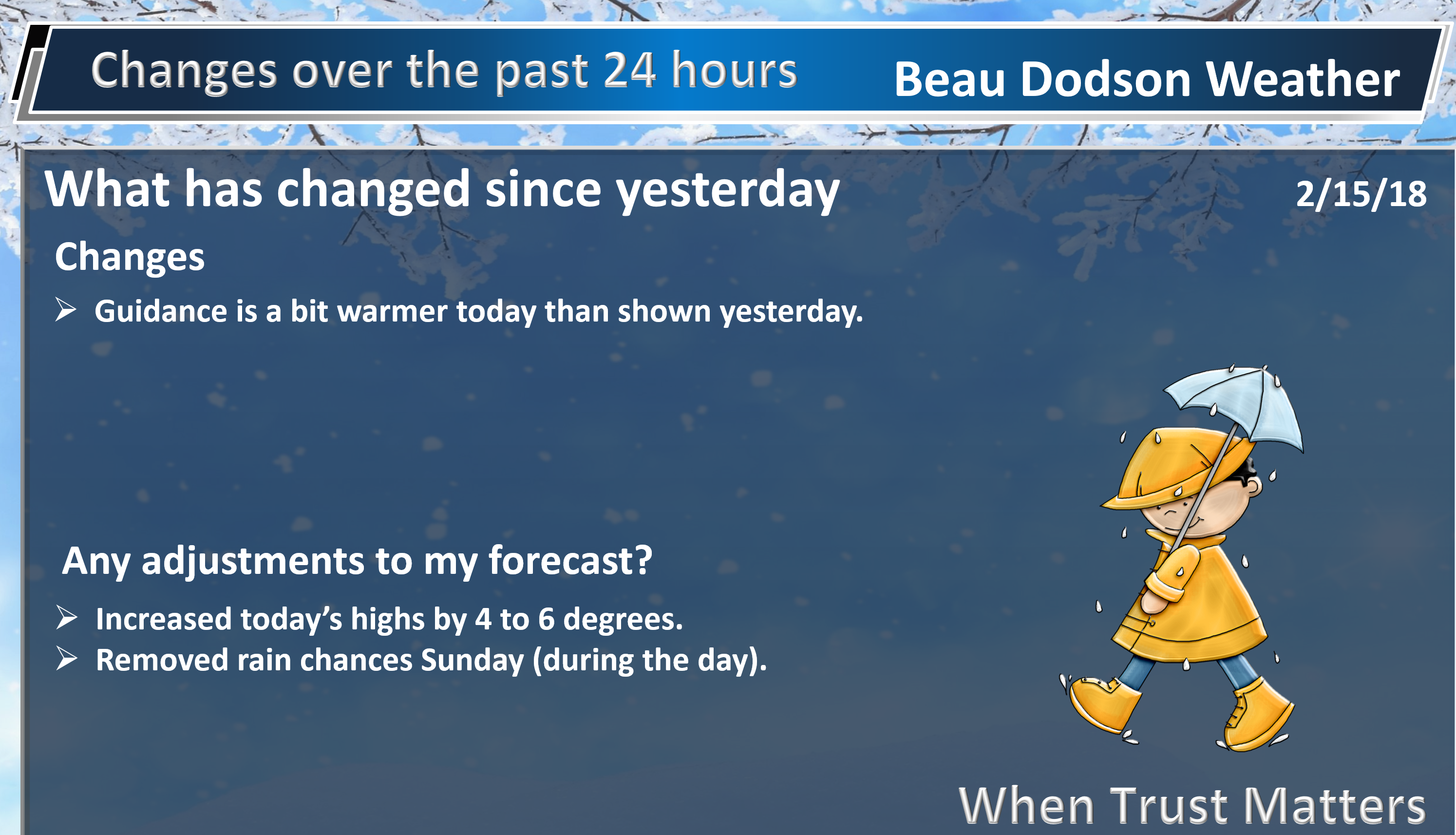
Thursday evening update
Not many changes to the going forecast. A cold front will swing through the region tonight. This front will trigger a band of showers and perhaps a few thunderstorms.
You can track the precipitation on our city view radars.
We offer regional radars and local city radars – if a radar does not update then try another one. Occasional browsers need their cache cleared. You may also try restarting your browser. This will usually fix any problems.
During the winter you can track snow and ice by clicking the winterize button on the local city view interactive radars.
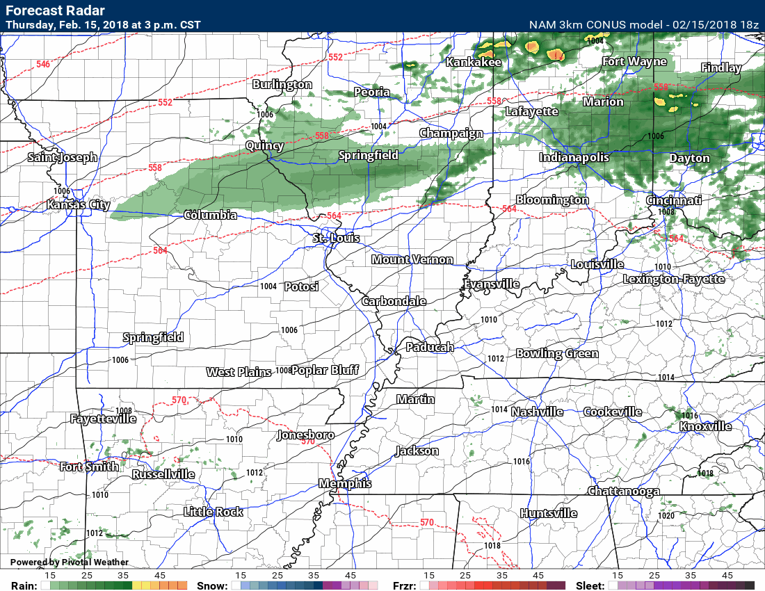
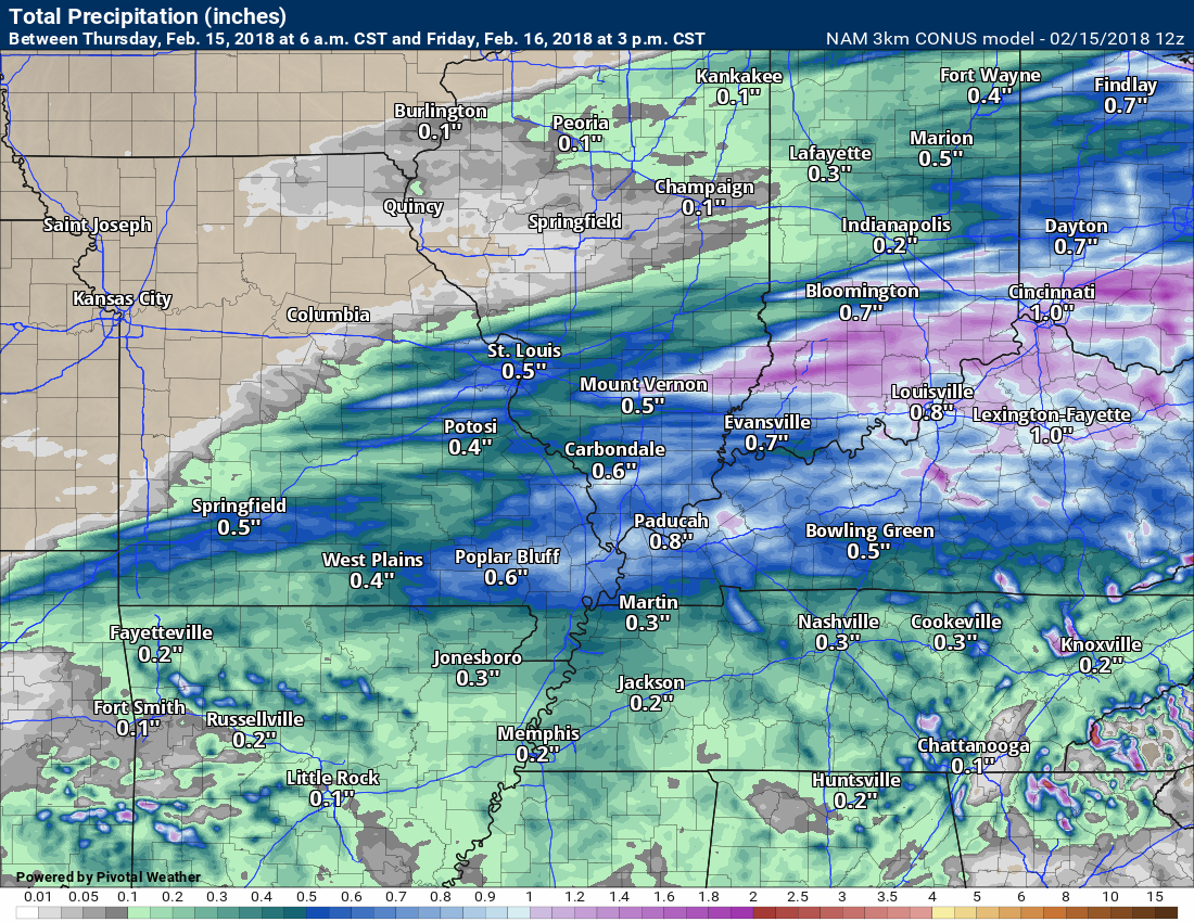
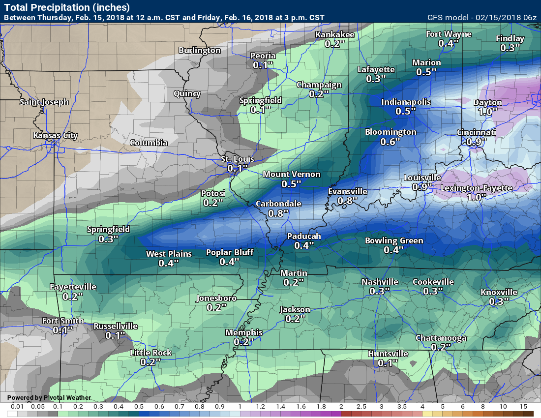
Here is the latest high-resolution 3K NAM model guidance future-cast radar. This is what radar might look like tonight into tomorrow morning.
Timestamp upper left.
Green is rain. Yellow is moderate rain. Blue is snow.
.
.
.

.
The videos have been updated for subscribers. Click here for the video updates.
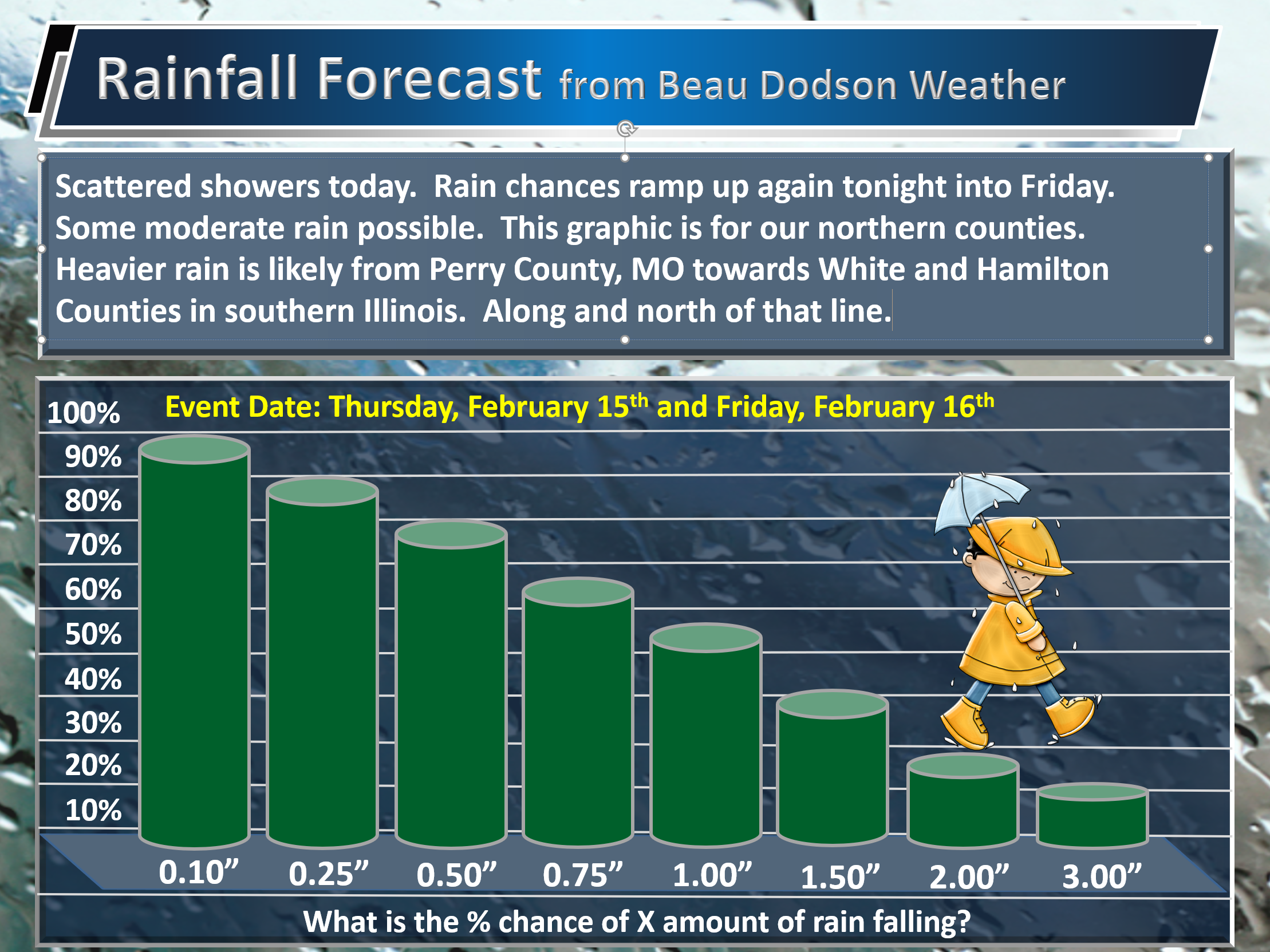
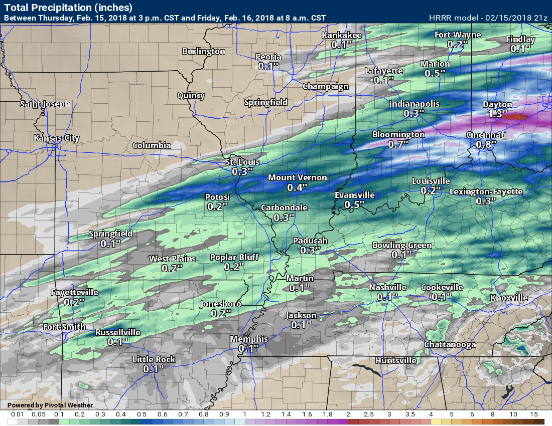
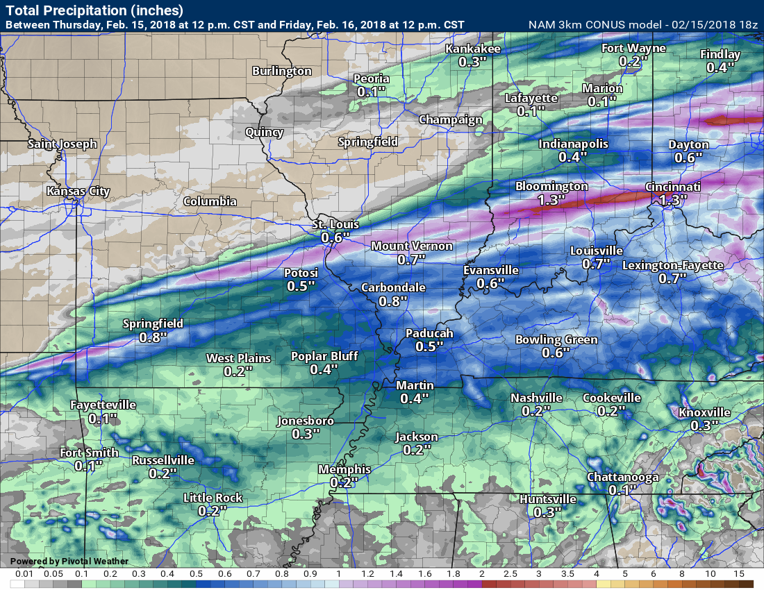
Rainfall totals:
Rainfall totals of 0.25″ to 0.50″ are anticipated with this band. There could be higher totals if a few thunderstorms form.
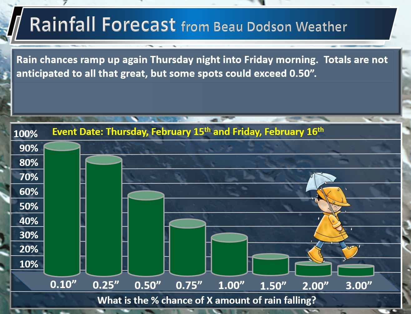
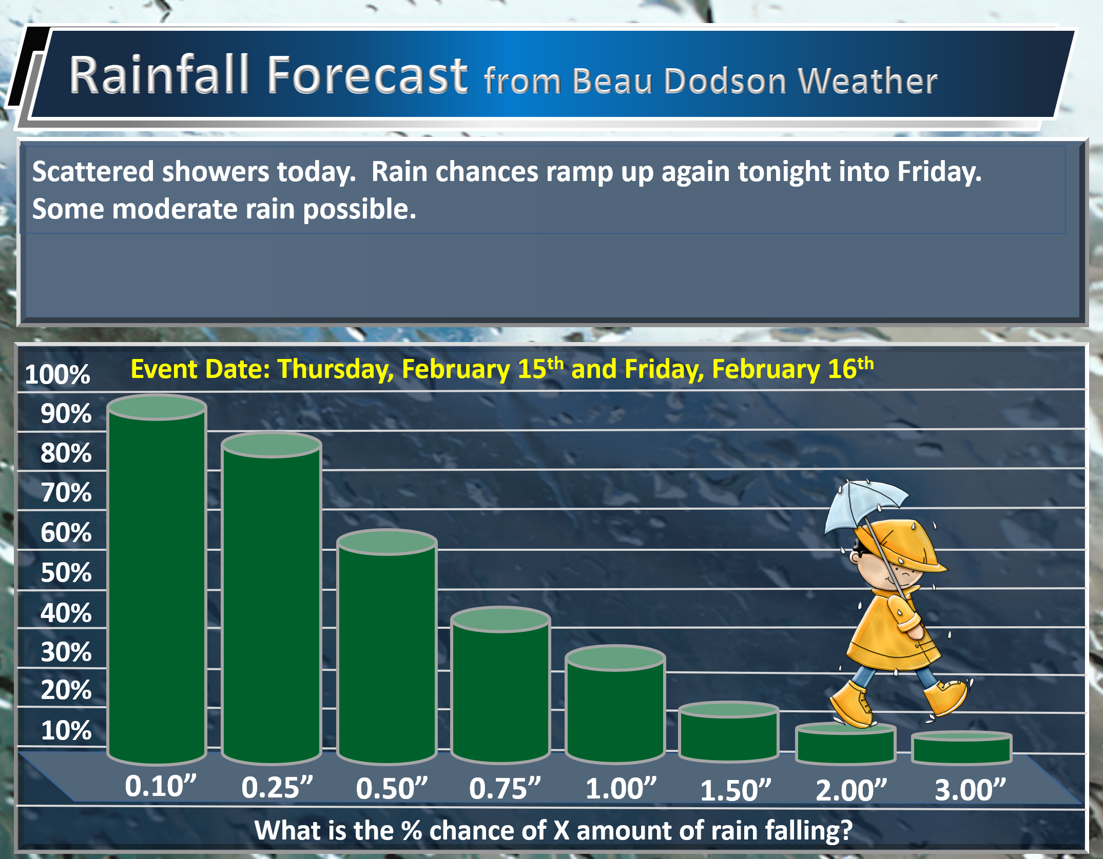
Here is my rainfall outlook for tonight into Friday morning. This is the % chance of X amount of rain falling.
.
.
Rain totals over our northern counties may be more. Training precipitation is possible before 2 AM.
.
.
Let me show you two graphics. Two different models. This is how much rain they believe will fall. Notice that higher band over our far northern counties.
.
.
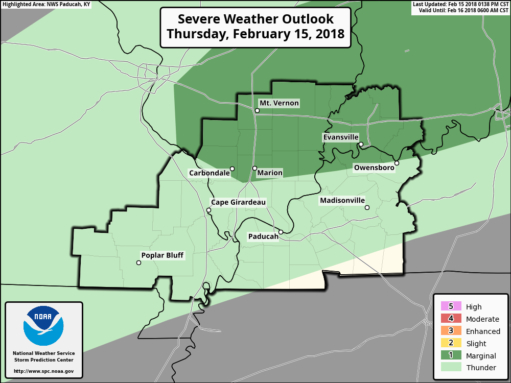
The Storm Prediction Center believes a couple of the storms could produce small hail and high winds. A small tornado risk. This would mainly be across portions of southern Illinois.
Here is the graphic for the severe weather risk zone. This is a level one of out of five risk zone. One being the lowest risk.
The dark green color is the marginal risk zone. They will update this graphic around 6 or 7 PM tonight.
.
.
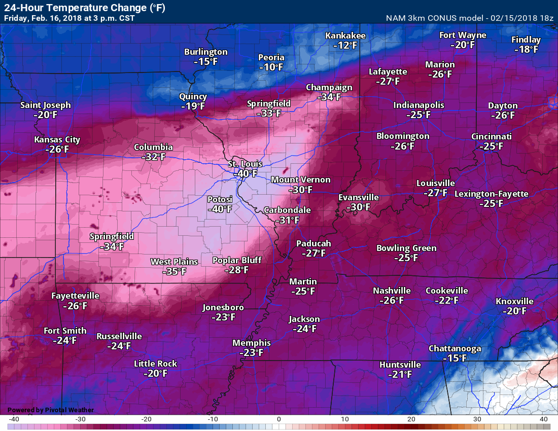
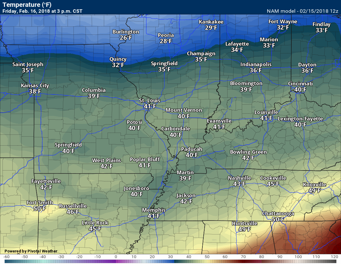
Colder air arrives Friday. Temperatures will struggle to move out of the upper 30’s to middle 40’s. Big difference from today.
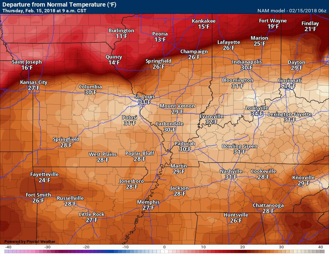
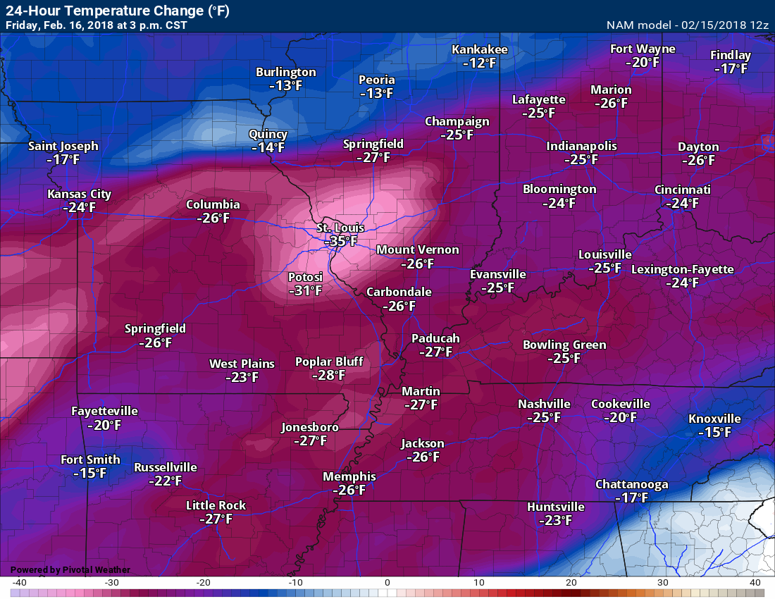
Check out the 24-hour temperature change map. This is from 3 PM Thursday to 3 PM Friday. How many degrees colder will it be?
.
.
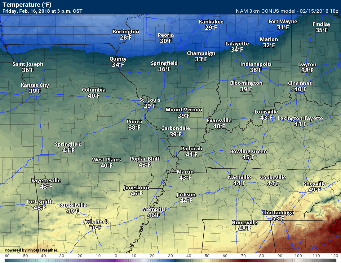
3 PM Friday actual air temperature forecast graphic
.
.
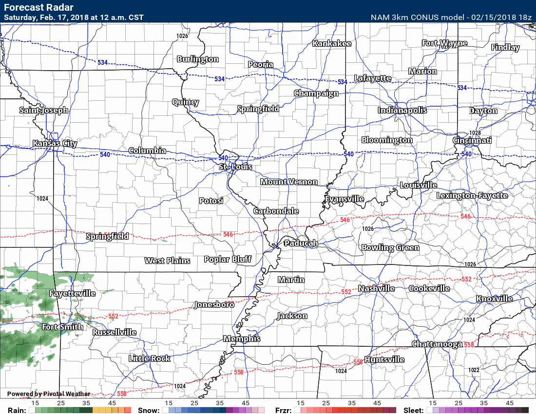
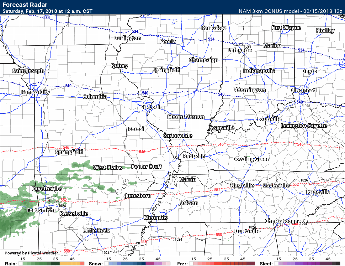
Yet another system will push through the region Friday night into Saturday morning. There could be enough cold air for a brief period of a wintry mix of freezing rain, snow, and rain. The best chance of that happening would be across southeast Missouri and southern Illinois.
Here is the latest high-resolution 3K NAM model guidance future-cast radar. This is what radar might look like Friday night into Saturday.
Notice the NAM guidance does produce some snow. We will see.
Temperatures will rise above freezing and into the 40’s Saturday. If snow does fall it won’t last. A slushy dusting to an inch or so of snow is possible.
Timestamp upper left.
Green is rain. Yellow is moderate rain. Blue is snow.
.
.
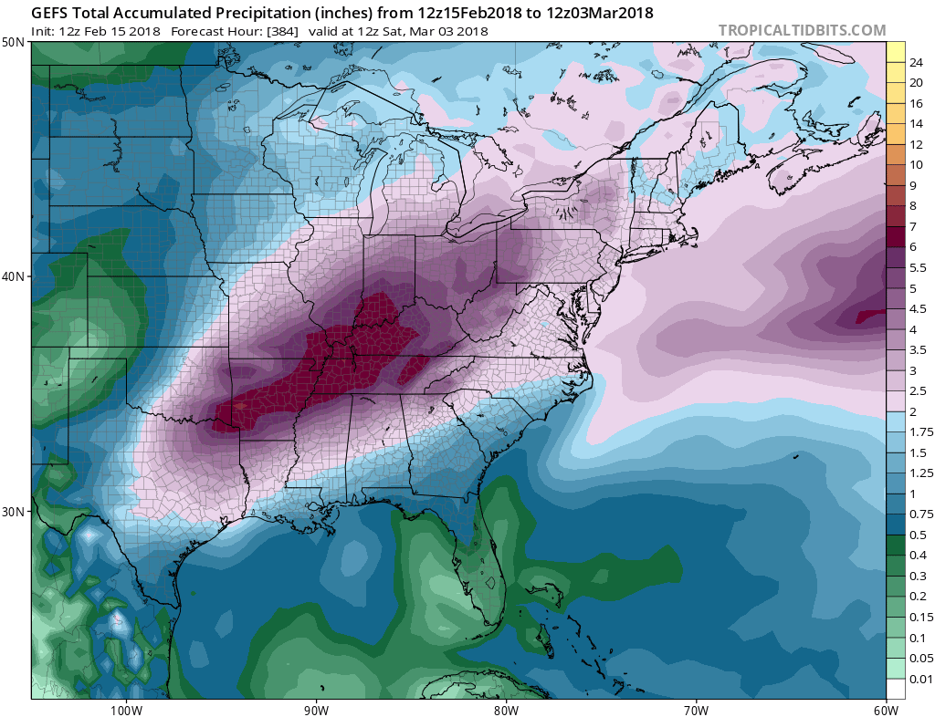
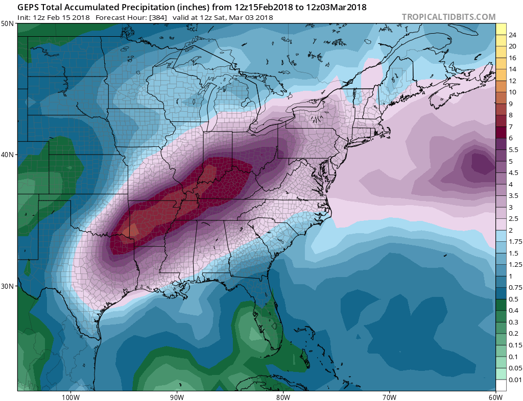
The next weather concern will be the potential of heavy rain over the next two weeks.
Rivers are already near or at flood stage. This will aggravate the flooding situation. If you have river interests then monitor updates.
Here is what two ensembles are painting for rainfall totals.
.
.
Keep in mind, these are models. Models are for guidance and are not gospel.
The models are showing a lot of rain. It remains to be seen just how much rain we will receive.
There is a strong signal for heavy rain.
.
.
and
.
.
Monitor updates moving forward. Rivers will rise.
.
This is what you are missing out on if you are not a $3 a month subscriber!
- Daily forecast texts from my computer to your app/cell phone
- Severe weather app/text alerts from my keyboard to your app/cell phone
- Social media links sent directly to your app/cell phone. When I update the blog, videos, or Facebook you will receive the link.
- Missouri Valley centered video updates
- Ohio Valley centered video updates
- Long-range video updates
- Week one temperature and precipitation outlook
- Week two temperature and precipitation outlook
- Week three and four temperature and precipitation outlook
- Monthly outlooks
Monthly operating costs for Weather Talk can top $2000.00. Your $3 subscription helps pay for those costs. I work for you.
.

.
Your $3 per month also helps support these local charity projects.
.

.
.

.
Interactive Weather Radar Page. Choose the city nearest your location: Click this link.
.
February 15, 2018
Thursday Forecast Details
Forecast: Mostly cloudy. Perhaps some sun here and there. Mild. Windy. A 30% of scattered showers and perhaps thunderstorms.. Some of the storms could produce gusty winds and brief downpours. There is a small risk of severe weather across mainly southern Illinois.
Temperatures: MO ~ 68 to 74 IL ~ 66 to 72 KY ~ 68 to 74
What is the chance of precipitation? MO ~ 30% IL ~ 30% KY ~ 30% TN ~ 30%
Coverage of precipitation: Widely scattered.
Wind chill values: N/A
Accumulating snow or ice: No
Winds: South and southwest at 15 to 35 mph and gusty. Wind gusts above 40 mph are possible today.
What impacts are anticipated from the weather? Wet roadways.
My confidence in the forecast verifying: High
Is severe weather expected? Low risk. The concern would be high winds and an isolated tornado risk.
The NWS defines severe weather as 58 mph wind or great, 1″ hail or larger, and/or tornadoes
Should I cancel my outdoor plans? No, but monitor radars.
.
Thursday Night Forecast Details:
Forecast: Cloudy. Mild. Breezy. Rain likely. Rain becoming more widespread as a front moves north to south. A rumble of thunder possible. A couple of thunderstorms could be intense. The main concern will be high winds. There is an isolated tornado risk. There is not a lot of CAPE to work with. CAPE is energy for thunderstorms. Wind fields aloft are strong. Bottom line, a couple of intense storms possible in the marginal risk zone.
Temperatures: MO ~ 38 to 44 IL ~ 38 to 44 KY ~ 42 to 46
What is the chance of precipitation? MO ~ 80% IL ~ 80% KY ~ 80% TN ~ 80%
Coverage of precipitation: Scattered showers followed by a period of widespread precipitation.
Wind chill values: N/A
Accumulating snow or ice: No. I can’t rule out a flurry over our northern counties towards Farmington, MO over towards Mt. Vernon, IL. Nothing to worry about.
Winds: South and southwest at 10 to 20 mph with gusts above 30 mph. Winds becoming west and northwest at 10 to 20 mph and gusty.
What impacts are anticipated from the weather? Wet roadways. Gusty winds.
My confidence in the forecast verifying: High
Is severe weather expected? No
The NWS defines severe weather as 58 mph wind or great, 1″ hail or larger, and/or tornadoes
Should I cancel my outdoor plans: Have a plan B and monitor updates.
.
February 16, 2018
Friday Forecast Details
Forecast: Mostly cloudy. Colder. Rain ending from north to south. Rain may end as light snow, but no accumulation anticipated. Steady temperatures or slowly falling. Gusty winds.
Temperatures: MO ~ 38 to 46 IL ~ 38 to 44 KY ~ 40 to 45
What is the chance of precipitation? MO ~ 60% IL ~ 60% KY ~ 70% TN ~ 70%
Coverage of precipitation: Perhaps widespread early in the day. Precipitation diminishing as the day wears on.
Wind chill values: 20 to 32
Accumulating snow or ice: Most likely no.
Winds: North and northwest at 10 to 20 mph. Higher gusts likely.
What impacts are anticipated from the weather? Wet roadways. Gusty winds.
My confidence in the forecast verifying: Medium
Is severe weather expected? No
The NWS defines severe weather as 58 mph wind or great, 1″ hail or larger, and/or tornadoes
Should I cancel my outdoor plans? Have a plan B and monitor updates.
.
Friday Night Forecast Details:
Forecast: Partly cloudy early. Becoming cloudy late. Colder. Rain may redevelop late Friday night into Saturday morning. The rain may be mixed with freezing rain or snow for a few hours. Snow accumulation of an inch or less. Many areas may not experience snow, but monitor updates.
Temperatures: MO ~ 26 to 32 IL ~ 25 to 30 KY ~ 26 to 32
What is the chance of precipitation? MO ~ 60% late IL ~ 50% late KY ~ 40% late TN ~ 40% late
Coverage of precipitation: Increasing coverage late Friday night.
Wind chill values: 20 to 26
Accumulating snow or ice: A slushy inch or so possible.
Winds: North and northeast at 6 to 12 mph with gusts to 20 mph
What impacts are anticipated from the weather? Monitor updates. Wet roadways, at least.
My confidence in the forecast verifying: Medium
Is severe weather expected? No
The NWS defines severe weather as 58 mph wind or great, 1″ hail or larger, and/or tornadoes
Should I cancel my outdoor plans: No, but monitor updates.
.
Confidence in the Saturday forecast is lower than normal. Monitor updates.
.
February 17, 2018
Saturday Forecast Details
Forecast: Mostly cloudy. A chance of snow or snow/freezing rain/rain mix. Precipitation becoming all rain. An inch or less accumulation.
Temperatures: MO ~ 38 to 44 IL ~ 38 to 44 KY ~ 40 to 45
What is the chance of precipitation? MO ~ 70% IL ~ 70% KY ~ 60% TN ~ 60%
Coverage of precipitation: A period of widespread precipitation likely.
Wind chill values: 28 to 38
Accumulating snow or ice: A slushy dusting to an inch or so possible over portions of southeast Missouri and southern Illinois. Elsewhere, monitor.
Winds: Variable 4 to 8 mph
What impacts are anticipated from the weather? Wet roadways. Monitor updates.
My confidence in the forecast verifying: LOW to medium
Is severe weather expected? No
The NWS defines severe weather as 58 mph wind or great, 1″ hail or larger, and/or tornadoes
Should I cancel my outdoor plans? Have a plan B and monitor updated forecasts.
.
Saturday Night Forecast Details:
Forecast: Clearing. Cool.
Temperatures: MO ~ 26 to 34 IL ~ 26 to 34 KY ~ 26 to 34
What is the chance of precipitation? MO ~ 10% IL ~ 10% KY ~ 20% TN ~ 20%
Coverage of precipitation: Any remaining precipitation will come to an end.
Wind chill values: 20 to 30
Accumulating snow or ice: Unlikely
Winds: Winds west and southwest at 4 to 8 mph
What impacts are anticipated from the weather? Wet roadways.
My confidence in the forecast verifying: Medium
Is severe weather expected? No
The NWS defines severe weather as 58 mph wind or great, 1″ hail or larger, and/or tornadoes
Should I cancel my outdoor plans: No
.
February 18, 2018
Sunday Forecast Details
Forecast: Partly sunny.
Temperatures: MO ~ 55 to 60 IL ~ 55 to 60 KY ~ 55 to 60
What is the chance of precipitation? MO ~ 0% IL ~ 0% KY ~ 0% TN ~ 0%
Coverage of precipitation: Most likely none
Wind chill values: N/A
Accumulating snow or ice: No
Winds: South and southeast winds at 5 to 10 mph
What impacts are anticipated from the weather? Most likely none
My confidence in the forecast verifying: Medium
Is severe weather expected? No
The NWS defines severe weather as 58 mph wind or great, 1″ hail or larger, and/or tornadoes
Should I cancel my outdoor plans? No
.
Sunday Night Forecast Details:
Forecast: Cloudy. Scattered showers developing.
Temperatures: MO ~ 48 to 54 IL ~ 48 to 54 KY ~ 48 to 54
What is the chance of precipitation? MO ~ 40% IL ~ 40% KY ~ 40% TN ~ 40%
Coverage of precipitation: Scattered
Wind chill values: N/A
Accumulating snow or ice: No
Winds: South and southwest winds at 8 to 16 mph
What impacts are anticipated from the weather? Wet roadways.
My confidence in the forecast verifying: Medium
Is severe weather expected? No
The NWS defines severe weather as 58 mph wind or great, 1″ hail or larger, and/or tornadoes
Should I cancel my outdoor plans: No, but monitor updates.
.
February 19, 2018
Monday Forecast Details
Forecast: Mostly cloudy. Scattered showers.
Temperatures: MO ~ 64 to 68 IL ~ 64 to 68 KY ~ 64 to 68
What is the chance of precipitation? MO ~ 60% IL ~ 60% KY ~ 60% TN ~ 60%
Coverage of precipitation: Scattered to perhaps widespread
Wind chill values: N/A
Accumulating snow or ice: No
Winds: South and southeast winds at 10 to 20 mph and gusty.
What impacts are anticipated from the weather? Wet roadways.
My confidence in the forecast verifying: Medium
Is severe weather expected? No
The NWS defines severe weather as 58 mph wind or great, 1″ hail or larger, and/or tornadoes
Should I cancel my outdoor plans? Have a plan B and monitor updates
.
Monday Night Forecast Details:
Forecast: Cloudy. Scattered showers re-developing.
Temperatures: MO ~ 52 to 56 IL ~ 52 to 56 KY ~ 52 to 56
What is the chance of precipitation? MO ~ 40% IL ~ 40% KY ~ 40% TN ~ 40%
Coverage of precipitation: Scattered to perhaps widespread
Wind chill values: N/A
Accumulating snow or ice: No
Winds: South and southwest winds at 8 to 16 mph and gusty
What impacts are anticipated from the weather? Wet roadways.
My confidence in the forecast verifying: Medium
Is severe weather expected? No
The NWS defines severe weather as 58 mph wind or great, 1″ hail or larger, and/or tornadoes
Should I cancel my outdoor plans: No, but monitor updates.
.

.
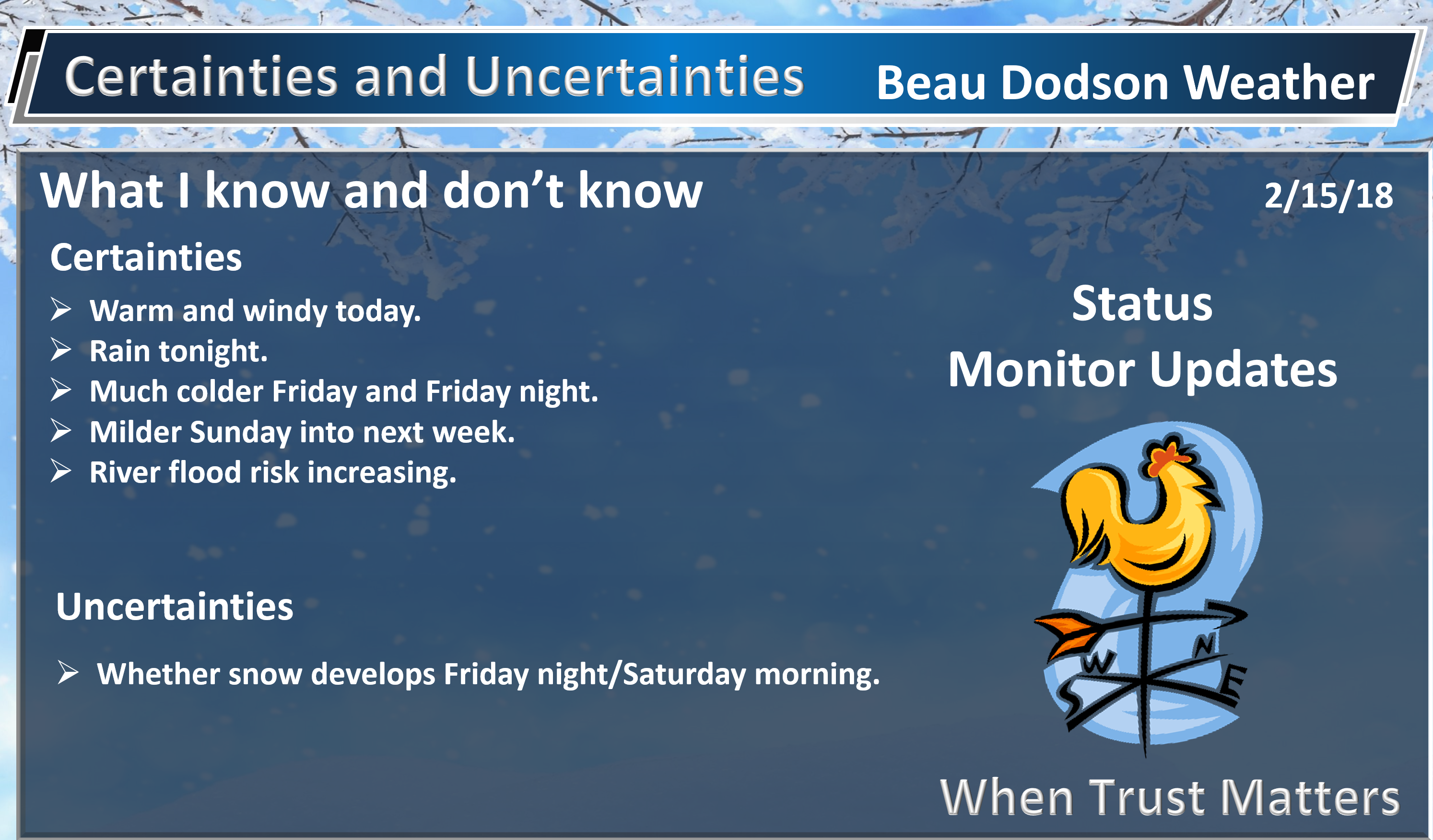
Thursday and Thursday night: Winter weather is not anticipated.
Friday: There is a small chance that the rain will end as light snow flurries. No accumulation (if it occurs).
Late Friday night through Saturday morning: Precipitation will return late Friday night into Saturday. A mixture of rain, freezing rain, and snow may occur across portions of the region late Friday night. The greatest chance of a wintry mix would be across southeast Missouri and southern Illinois. Temperatures should rise above freezing area-wide by late Saturday morning. Accumulation of one inch or less. Many areas may remain rain. Monitor updates.
Saturday afternoon into Wednesday: Winter weather is not anticipated.
.

.
The National Weather Service definition of a severe thunderstorm is one that produces quarter size hail or larger, 58 mph winds or greater, and/or a tornado.
Now through Friday: Severe weather is not in the forecast. I can’t rule out a few lightning strikes Thursday into Thursday night.
.

.
The daily outlook can be found at the bottom of this post.

We offer regional radars and local city radars – if a radar does not update then try another one. Occasional browsers need their cache cleared. You may also try restarting your browser. This will usually fix any problems.
During the winter you can track snow and ice by clicking the winterize button on the local city view interactive radars.
.
.
.
.
.
Rainfall forecast through Friday afternoon.
A few scattered showers are possible today. Rain totals will be less than 0.20″.
Rain chances ramp up tonight into Friday. Widespread rain is anticipated.
Rainfall totals from this event will likely range from 0.25″ to 0.50″. Pockets of higher totals are certainly possible.
This is my “what is the % chance of X amount of rain falling” graphic.
.
.
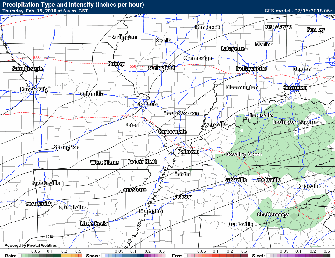
Here is what the NAM model guidance shows for the Thursday night into Friday event.
.
.
Here is what the GFS guidance shows for the Thursday night into Friday event.
.
.
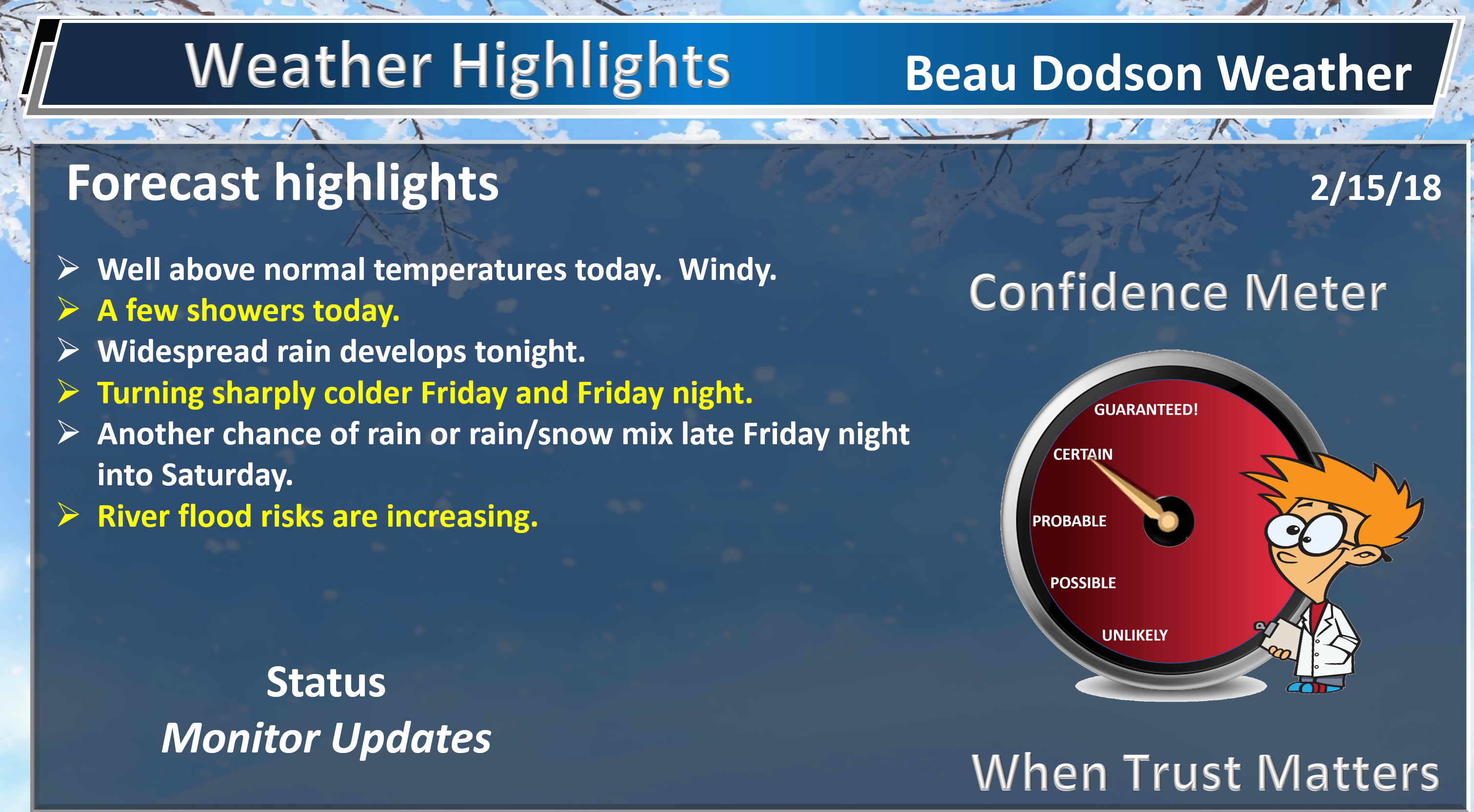
Forecast:
HIGHLIGHTS
- Warm today with well above normal temperatures. Windy, as well.
- A strong cold front arrives late Thursday night into Friday morning. Falling temperatures behind the front.
- Rain may briefly mix with or change to snow Friday morning/afternoon. At this time, no accumulation anticipated. Most areas will likely not see snowflakes.
- Another round of precipitation likely Friday night into Saturday. A rain or rain/snow mix changing to rain.
High confidence today through Friday afternoon.
Low confidence in the forecast Friday night through Monday.
Scattered showers are possible today. Temperatures will be quite warm. It has been awhile since we have experienced temperatures this warm. Many areas may top 70 degrees. Yes, 70 degrees!
Check out the temperature departure map for today. How many degrees above normal will temperatures be?
.
.
That is a warm map!
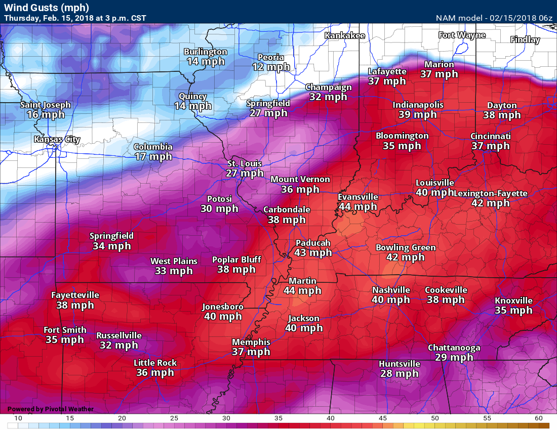
It will be windy today. Winds will gust between 20 to 30 mph. Higher gusts likely from time to time.
Thursday 3 PM wind gust map.
.
.
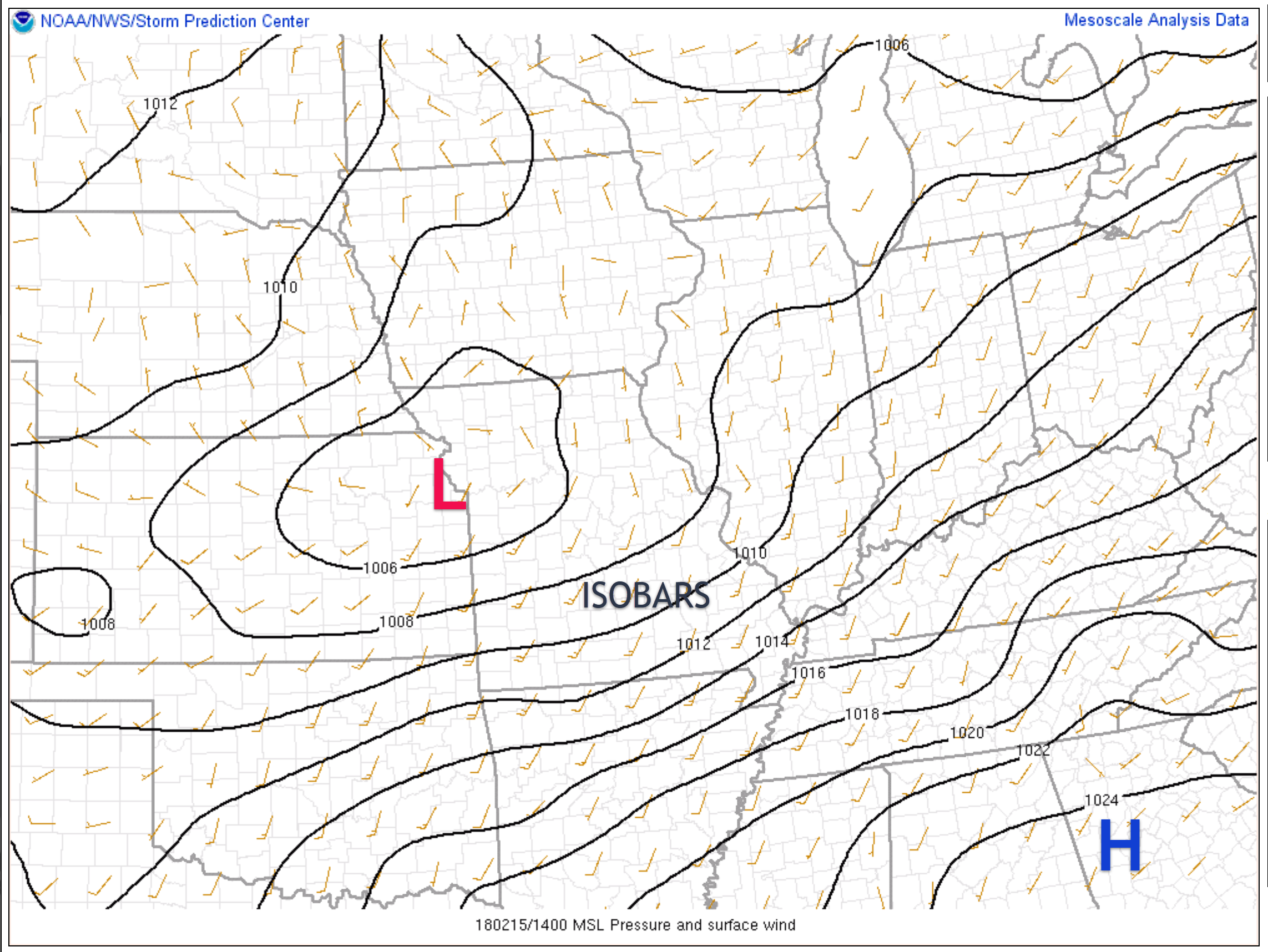
The winds will be gusty in response to a tightening pressure gradient across our region. Barometric pressure. These black lines, on the map below, are called isobars. When these lines are closely packed together it means gusty winds are likely to occur.
Here is the 9 AM surface map. You can see an area of low pressure over Kansas City. High pressure to our southeast.
.
.
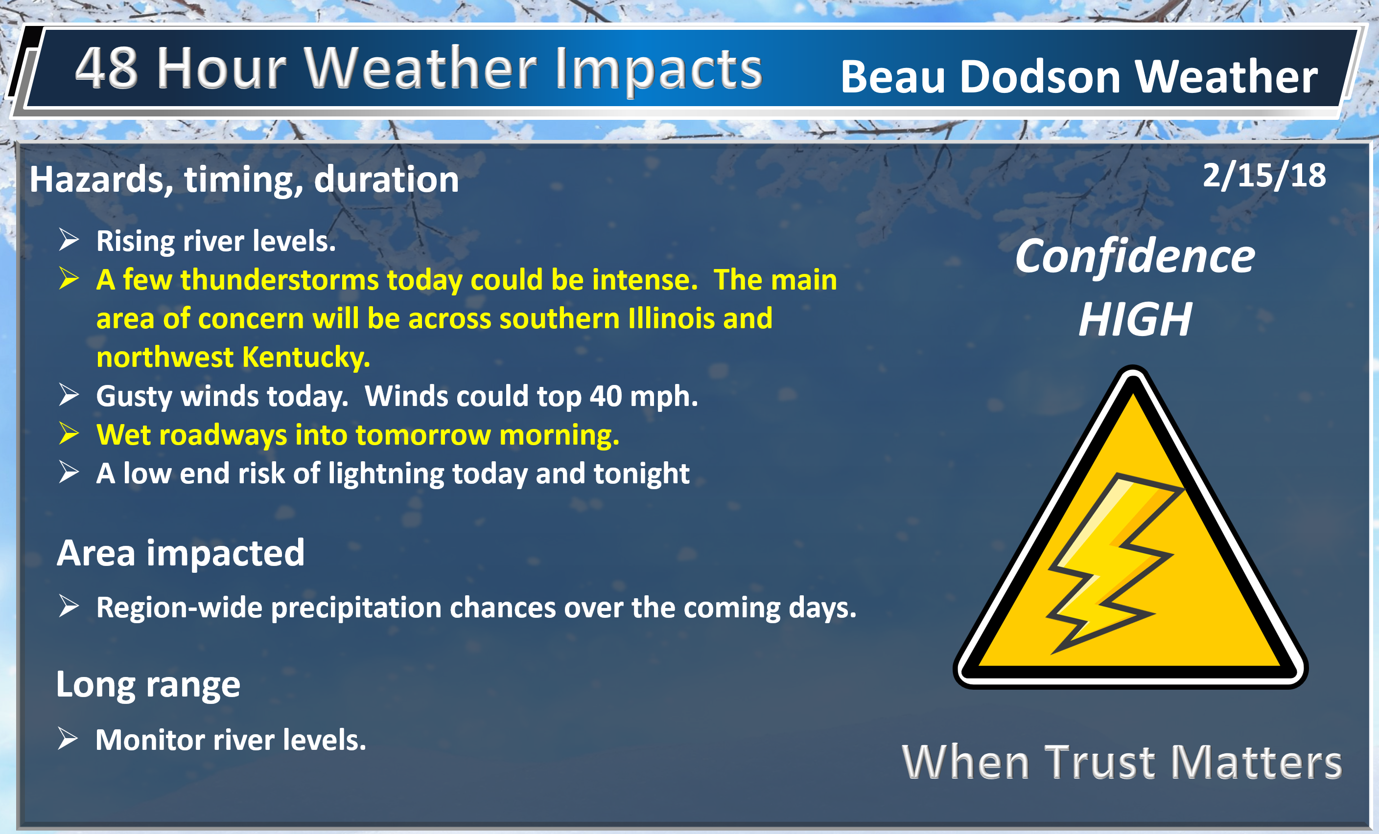
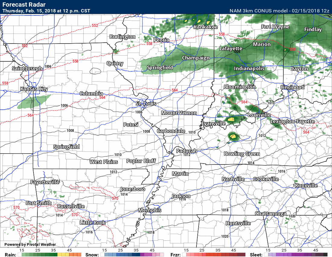
A strong cold front will push through the region late Thursday night into Friday morning. This front will be accompanied by showers and a few thunderstorms. Gusty winds, as well.
Here is the future-cast radar for later tonight into Friday afternoon. Green is rain. Yellow is heavier downpours. Blue is snow.
Timestamp upper left. Click to enlarge the graphics on this page.
.
.
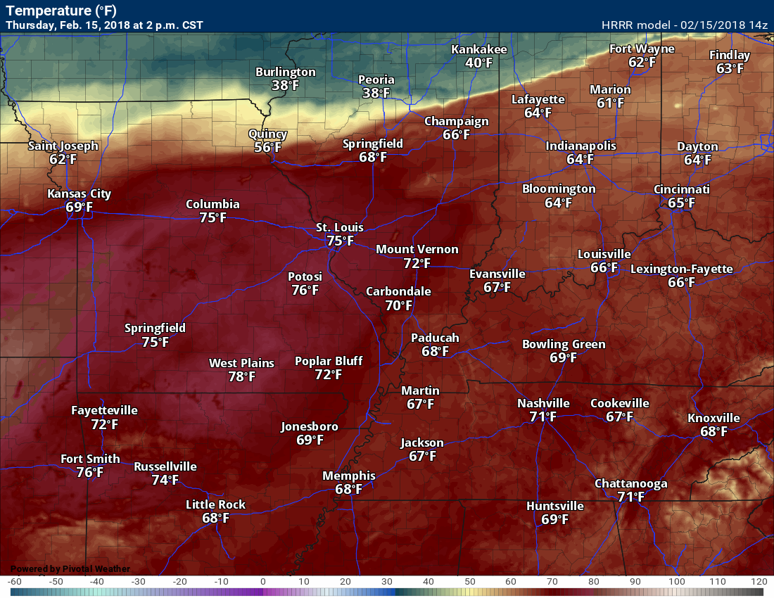
Temperatures will be colder behind the cold front.
Highs today will top out in the 68 to 74-degree range. Temperatures on Friday will dip into the 30’s. Big swing, but not unusual for the Month of February.
Thursday high-temperature map from the GFS guidance (it is on the warmer side of guidance).
It has a stripe of upper 60’s across portions of the region. This is in response to some showers. We will have to see how that pans out. Either way, it will be warm.
.
.
Friday 3 PM temperature map. Big change. Don’t worry, the milder air will return next week.
.
.
Here is the temperature change map centered on Friday afternoon. How many degrees colder will it be from 3 PM Thursday to 3 PM Friday?
.
.
There remain questions about the Friday night into Saturday forecast.
The differences in guidance center around how far north a frontal boundary moves. If it remains well to our south then we will not have to deal with precipitation. If it is further north, then rain and wintry mix chances ramp back up Friday night into Saturday.
At this time, it does appear that another widespread rain event is likely Friday night into Saturday. The rain may begin as a wintry mix. Accumulation, if any, will be light.
The wintry mix would only last a few hours. Temperatures will rise into the 40’s Saturday. That would mean everything changes back over to rain.
.
.
A wet pattern is developing. There are concerns about just how wet.
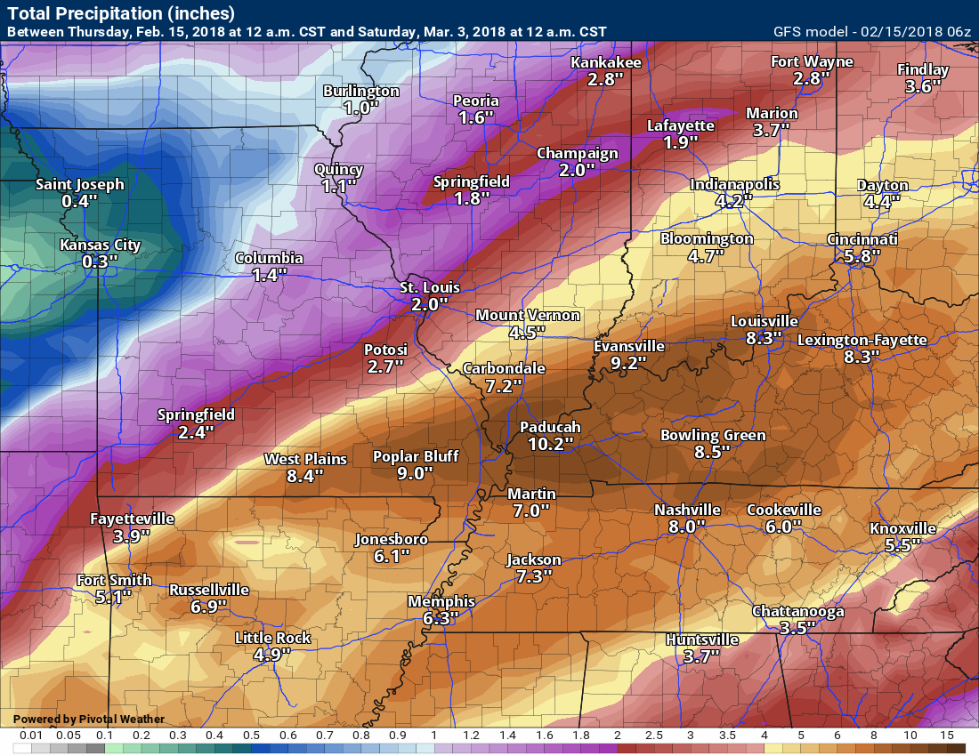
Here is the future-cast radar from the GFS model. This takes us into the first few days of March. Granted, there is no way the model will be accurate that far out. What I wanted to show you was just how active the pattern is forecast to be.
I will need to work out the forecast details. The bottom line is that we may experience several inches of rain over the coming weeks. Rivers are already high across much of the region. Additional rain will only worsen the problem.
Timestamp upper left.
Green represents rain. Blue would be snow.
.
.
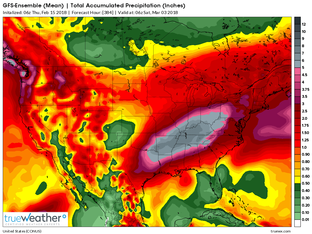
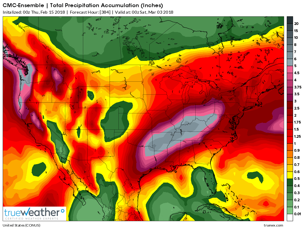
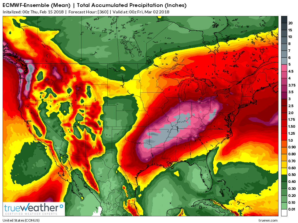
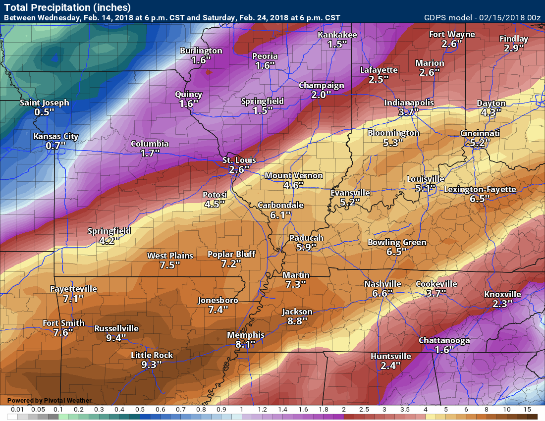
Here are three different models. The GFS, the GEM, and the EC.
All three show the same thing. Heavy rain in our region.
Will we receive THIS much rain? That is an unknown.
I am showing you these maps to show you that there is the signal for heavy rain in our region over the coming weeks. The details will need to be worked out.
.
.
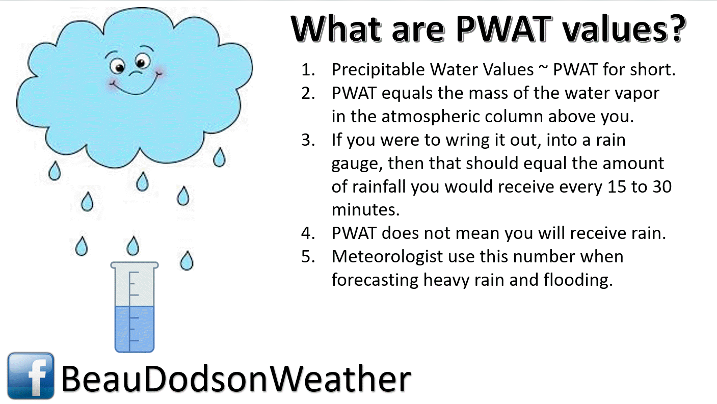
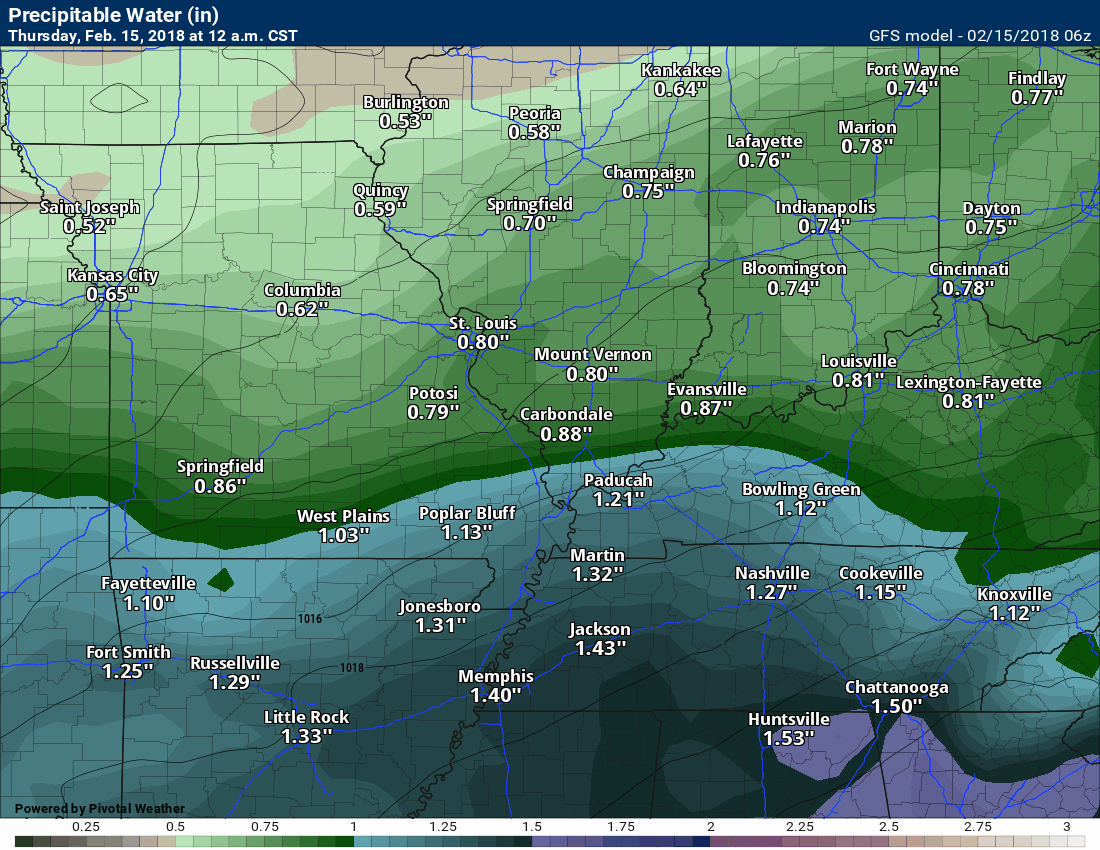
An extended period of high PWAT values is showing up in the charts. What is PWAT?
More information here. Click here.
.
.
Here are the GFS model guidance PWAT values into the first of March. The high values keep returning.
This may take awhile to load on some devices. Loop.
.
.
The GFS model has been painting some extreme rainfall totals for our region. This graphic takes us into the first couple of days of March.
Of course, the model won’t be exactly right. What is concerning is the number of runs that keep showing the same thing. The GFS runs four times each day. It has been showing significant rainfall each time.
It is not alone in painting big numbers. The GEM and EC model guidance does the same.
AGAIN, THIS IS NOT A FORECAST MAP. I am only showing you this graphic to give you an idea of what the models are showing.
There is the potential of heavy rain over the coming weeks. The details will need to be ironed out.
.
.
Here is the Canadian model. Rainfall totals through February 24th.
Just one model’s opinion.
.
 .
.
.
We will need to monitor river stages. Rivers are going to rise over the coming weeks.
.
.
The preliminary summer forecast has been posted on the subscription website. Subscribe at www.beaudodsonweather.com
Summer outlook – Click here
.


We offer regional radars and local city radars – if a radar does not update then try another one. Occasional browsers need their cache cleared. You may also try restarting your browser. This will usually fix any problems.
During the winter you can track snow and ice by clicking the winterize button on the local city view interactive radars.
You may email me at beaudodson@usawx.com
Interactive Weather Radar Page. Choose the city nearest your location: Click this link
National interactive radar: Click this link.