A general spring and summer outlook has been posted. More details will be posted over time.
Bonus maps and videos have been updated.
Link to the long range outlooks (Scroll down to the 2nd post at this link for the latest long range outlook) and videos (for subscribers) – Click here
You haven’t subscribed? Subscribe at www.beaudodsonweather.com
Monthly operating costs for Weather Talk can top $2000.00. Your $3 subscription helps pay for those costs. I work for you.
.

.
Tuesday Night Forecast Details:
Forecast: Becoming cloudy. Rain chances will increase through the night. A few thunderstorms possible after midnight. Moderate rain possible.
Temperatures: MO ~ 38 to 44 IL ~ 38 to 44 KY ~ 38 to 44
What is the chance of precipitation? MO ~ 60% IL ~ 60% KY ~ 90% TN ~ 100%
Coverage of precipitation: Scattered far northern counties (Farmington, MO towards Mt Vernon, IL). Becoming widespread the rest of the region.
Wind chill values: 30 to 40
Accumulating snow or ice: No
Winds: South and southwest at 4 to 8 mph with gusts to 12 mph
What impacts are anticipated from the weather? Wet roadways. Lightning possible.
My confidence in the forecast verifying: High
Is severe weather expected? No
The NWS defines severe weather as 58 mph wind or great, 1″ hail or larger, and/or tornadoes
Should I cancel my outdoor plans: No
.
February 14, 2018
Wednesday Forecast Details
Forecast: Mostly cloudy. Morning rain likely. A rumble of thunder possible early. Rain chances will decrease during the mid morning to mid afternoon time frame from west to east. Rainfall totals from Tuesday night through Wednesday mid-day will likely range from 0.20″ to 0.70″. Highest totals from the Missouri Bootheel into extreme southern Illinois, western Kentucky, and northwest Tennessee.
Temperatures: MO ~ 56 to 62 IL ~ 56 to 62 KY ~ 56 to 62
What is the chance of precipitation? MO ~ 60% before 12 pm IL ~ 60% before 12 pm KY ~ 80% before 12 pm TN ~ 70% before 12 pm
Coverage of precipitation: Widespread early in the day. Diminishing as the day wears on.
Wind chill values: N/A
Accumulating snow or ice: No
Winds: South and southwest at 7 to 14 mph with gusts to 20
What impacts are anticipated from the weather? Wet roadways. Lightning possible early in the day.
My confidence in the forecast verifying: High
Is severe weather expected? No
The NWS defines severe weather as 58 mph wind or great, 1″ hail or larger, and/or tornadoes
Should I cancel my outdoor plans? Have a plan B and monitor updates.
.
Wednesday Night Forecast Details:
Forecast: Cloudy. Mild. Breezy. A few scattered showers possible. Temperatures holding steady or slowly rising.
Temperatures: MO ~ 53 to 56 IL ~ 52 to 56 KY ~ 54 to 58
What is the chance of precipitation? MO ~ 40% IL ~ 40% KY ~ 40% TN ~ 40%
Coverage of precipitation: Scattered
Wind chill values: N/A
Accumulating snow or ice: No
Winds: South and southwest at 10 to 20 mph with gusts above 25 mph.
What impacts are anticipated from the weather? Wet roadways
My confidence in the forecast verifying: Medium
Is severe weather expected? No
The NWS defines severe weather as 58 mph wind or great, 1″ hail or larger, and/or tornadoes
Should I cancel my outdoor plans: Have a plan B and monitor updates.
.
February 15, 2018
Thursday Forecast Details
Forecast: Mostly cloudy. Perhaps some patches of sunshine, as well. A chance of showers and maybe a thunderstorm mainly after 12 pm and more likely into Thursday night. Mild. Breezy.
Temperatures: MO ~ 64 to 68 IL ~ 64 to 68 KY ~ 65 to 70
What is the chance of precipitation? MO ~ 40% IL ~ 40% KY ~ 40% TN ~ 40%
Coverage of precipitation: Scattered
Wind chill values: N/A
Accumulating snow or ice: No
Winds: South and southwest at 10 to 20 mph with gusts to 35 mph
What impacts are anticipated from the weather? Wet roadways. Windy conditions Perhaps lightning.
My confidence in the forecast verifying: Medium
Is severe weather expected? No
The NWS defines severe weather as 58 mph wind or great, 1″ hail or larger, and/or tornadoes
Should I cancel my outdoor plans? Have a plan B and monitor updates.
.
Thursday Night Forecast Details:
Forecast: Cloudy. Showers increasing from north to south. Widespread rain developing. A rumble of thunder possible. Breezy.
Temperatures: MO ~ 34 to 43 IL ~ 34 to 38 KY ~ 38 to 46 (warmest towards Hopkinsville vs Paducah)
What is the chance of precipitation? MO ~ 80% IL ~ 80% KY ~ 80% TN ~ 80%
Coverage of precipitation: Becoming widespread.
Wind chill values: N/A
Accumulating snow or ice: No
Winds: South and southwest at 10 to 25 mph and gusty. Winds will shift behind the cold front to west and northwest.
What impacts are anticipated from the weather? Wet roadways. Gusty winds. Lightning possible.
My confidence in the forecast verifying: Medium
Is severe weather expected? No
The NWS defines severe weather as 58 mph wind or great, 1″ hail or larger, and/or tornadoes
Should I cancel my outdoor plans: Have a plan B and monitor updates.
.
February 16, 2018
Friday Forecast Details
Forecast: Mostly cloudy. Colder. Rain showers. Rain may end as light snow showers.
Temperatures: MO ~ 38 to 46 IL ~ 38 to 44 KY ~ 40 to 45
What is the chance of precipitation? MO ~ 50% IL ~ 50% KY ~ 60% TN ~ 60%
Coverage of precipitation: Scattered to perhaps widespread. Precipitation chances decreasing as the day wears on.
Wind chill values: N/A
Accumulating snow or ice: Most likely no, but monitor updates.
Winds: North and northwest at 10 to 20 mph.
What impacts are anticipated from the weather? Wet roadways.
My confidence in the forecast verifying: Medium
Is severe weather expected? No
The NWS defines severe weather as 58 mph wind or great, 1″ hail or larger, and/or tornadoes
Should I cancel my outdoor plans? Have a plan B and monitor updates.
.
Friday Night Forecast Details:
Forecast: Mostly cloudy. Colder. A 30% of light rain and snow or wintry mix.
Temperatures: MO ~ 24 to 28 IL ~ 24 to 28 KY ~ 24 to 28
What is the chance of precipitation? MO ~ 30% IL ~ 30% KY ~ 30% TN ~ 30%
Coverage of precipitation: Scattered mainly over our southern counties (Bootheel of MO into western KY)
Wind chill values: N/A
Accumulating snow or ice: Most likely no, but monitor updates.
Winds: North and northeast at 5 to 10 mph with gusts to 14 mph
What impacts are anticipated from the weather? Monitor
My confidence in the forecast verifying: LOW
Is severe weather expected? No
The NWS defines severe weather as 58 mph wind or great, 1″ hail or larger, and/or tornadoes
Should I cancel my outdoor plans: Have a plan B and monitor updates.
.
Confidence in the Saturday and Sunday forecast is LOW. Monitor updates.
.
February 17, 2018
Saturday Forecast Details
Forecast: Mostly cloudy. A 30% of rain or wintry mix. Low confidence on precipitation chances. A second system may bring additional precipitation chances into the region.
Temperatures: MO ~ 44 to 48 IL ~ 44 to 48 KY ~ 44 to 48
What is the chance of precipitation? MO ~ 30% IL ~ 30% KY ~ 30% TN ~ 30%
Coverage of precipitation: Monitor
Wind chill values: N/A
Accumulating snow or ice: Monitor
Winds: North and northwest at 7 to 14 mph. Winds becoming variable late in the day.
What impacts are anticipated from the weather? Monitor
My confidence in the forecast verifying: LOW
Is severe weather expected? No
The NWS defines severe weather as 58 mph wind or great, 1″ hail or larger, and/or tornadoes
Should I cancel my outdoor plans? No
.
Saturday Night Forecast Details:
Forecast: Mostly cloudy. Monitor precipitation chances. Low confidence.
Temperatures: MO ~ 26 to 34 IL ~ 26 to 34 KY ~ 26 to 34
What is the chance of precipitation? MO ~ 30% IL ~ 30% KY ~ 30% TN ~ 30%
Coverage of precipitation: Monitor
Wind chill values: N/A
Accumulating snow or ice: Monitor
Winds: North and northeast at 5 to 10 mph with gusts to 14 mph
What impacts are anticipated from the weather? Monitor
My confidence in the forecast verifying: LOW
Is severe weather expected? No
The NWS defines severe weather as 58 mph wind or great, 1″ hail or larger, and/or tornadoes
Should I cancel my outdoor plans: Monitor
.
February 18, 2018
Sunday Forecast Details
Forecast: Increasing clouds. Showers possible. A bit milder.
Temperatures: MO ~ 48 to 54 IL ~ 48 to 54 KY ~ 48 to 54
What is the chance of precipitation? MO ~ 30% IL ~ 30% KY ~ 30% TN ~ 30%
Coverage of precipitation: Scattered
Wind chill values: N/A
Accumulating snow or ice: No
Winds: South and southwest winds at 6 to 12 mph
What impacts are anticipated from the weather? Wet roadways
My confidence in the forecast verifying: LOW
Is severe weather expected? No
The NWS defines severe weather as 58 mph wind or great, 1″ hail or larger, and/or tornadoes
Should I cancel my outdoor plans? No, but monitor updates.
.
Sunday Night Forecast Details:
Forecast: Cloudy. Scattered showers.
Temperatures: MO ~ 36 to 44 IL ~ 36 to 44 KY ~ 36 to 44
What is the chance of precipitation? MO ~ 40% IL ~ 40% KY ~ 40% TN ~ 40%
Coverage of precipitation: Scattered
Wind chill values: N/A
Accumulating snow or ice: No
Winds: South and southwest winds at 6 to 12 mph becoming west.
What impacts are anticipated from the weather? Wet roadways.
My confidence in the forecast verifying: LOW
Is severe weather expected? No
The NWS defines severe weather as 58 mph wind or great, 1″ hail or larger, and/or tornadoes
Should I cancel my outdoor plans: No, but monitor updates.
.
Interactive Weather Radar Page. Choose the city nearest your location: Click this link.
.

.
Tuesday through Thursday night: Winter weather is not anticipated.
Friday: Snow flurries or snow showers are possible as the cold front pushes southward through the region. This would occur as the rain comes to an end. Accumulation appears unlikely.
Late Friday night through Sunday: Monitor updates. Another system might move into the region late Friday night into Saturday. There is significant disagreement about the forecast during this time frame.
.

.
The National Weather Service definition of a severe thunderstorm is one that produces quarter size hail or larger, 58 mph winds or greater, and/or a tornado.
Now through Friday: Severe weather is not in the forecast. Lightning is possible Tuesday night and Wednesday morning and again Thursday night.
.

.
Interactive Weather Radar Page. Choose the city nearest your location: Click this link.
.
.
.
.
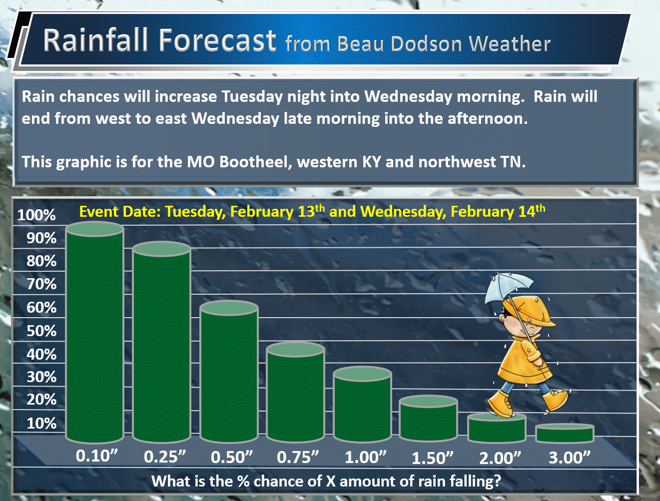
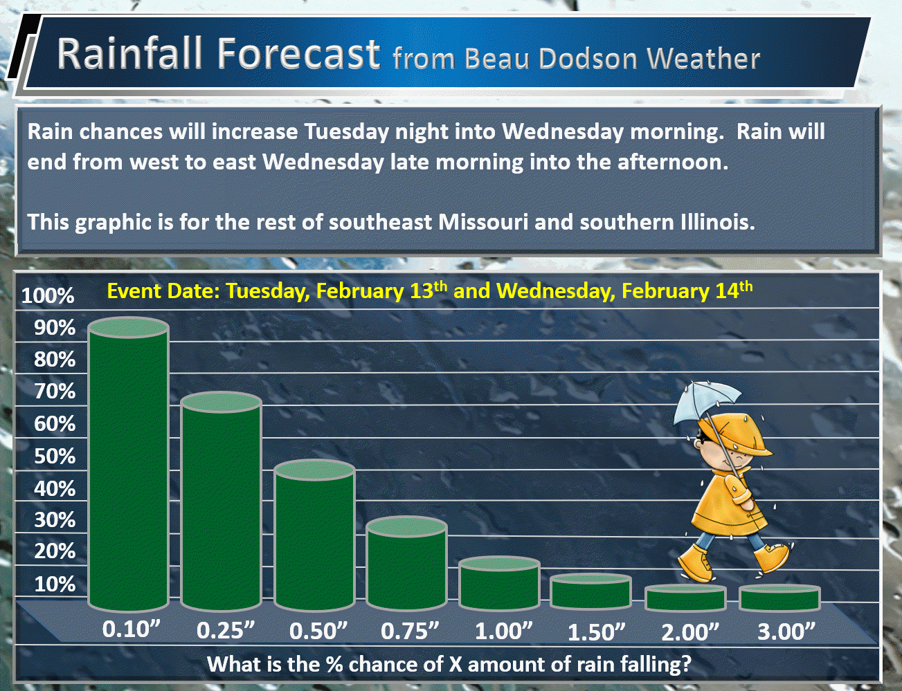
Rainfall forecast.
What is the % chance of X amount of rain falling.
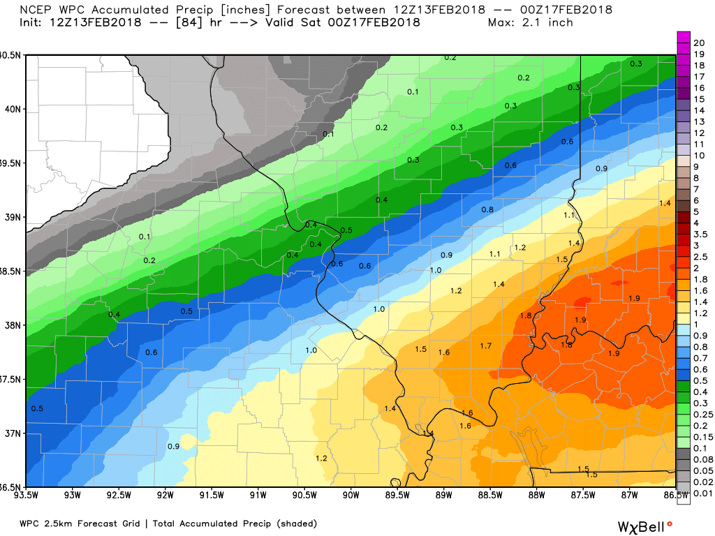
The Missouri Bootheel, western Kentucky, and northwest Tennessee
.
.
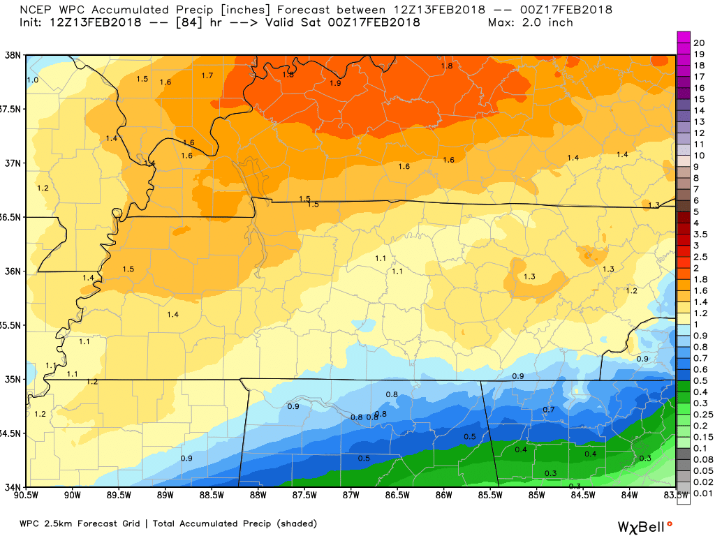
The rest of southeast Missouri and southern Illinois.
.
.
We will need to monitor river stages over the coming weeks.
.

.
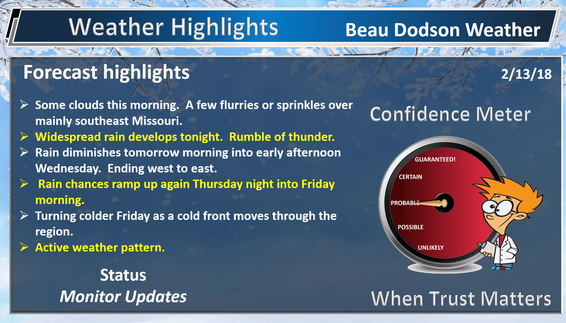
Forecast:
HIGHLIGHTS
- Clouds today. A mix of sun and clouds.
- Rain chances ramp up tonight with a few thunderstorms after midnight.
- A strong cold front arrives on Friday. Falling temperatures behind the front.
- Rain may briefly mix with or change to snow Friday morning/afternoon. At this time, no accumulation anticipated.
- Confidence in the Friday night (late) into Sunday forecast is low. Monitor updates concerning precipitation.
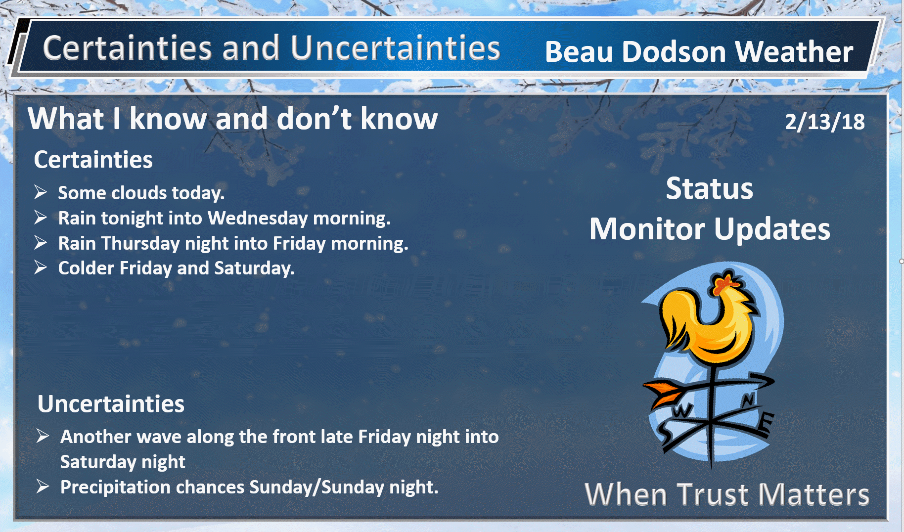
High confidence today through Thursday.
Medium confidence from Thursday night into Friday.
Low confidence in the forecast Friday night through Monday.
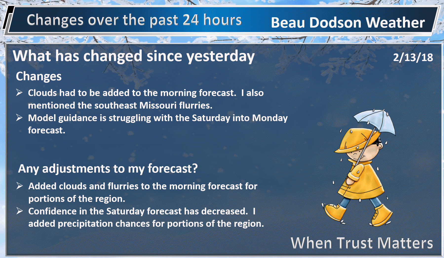
We have a few more clouds than anticipated this morning. Gulf of Mexico air is streaming northward. This is helping with the cloud development. There have even been a few flurries over southeast Missouri.
Here is what radar looked like at 7 AM. The orange color represents snow flurries. Perhaps a few sleet pellets, as well. Nothing significant.
.
.
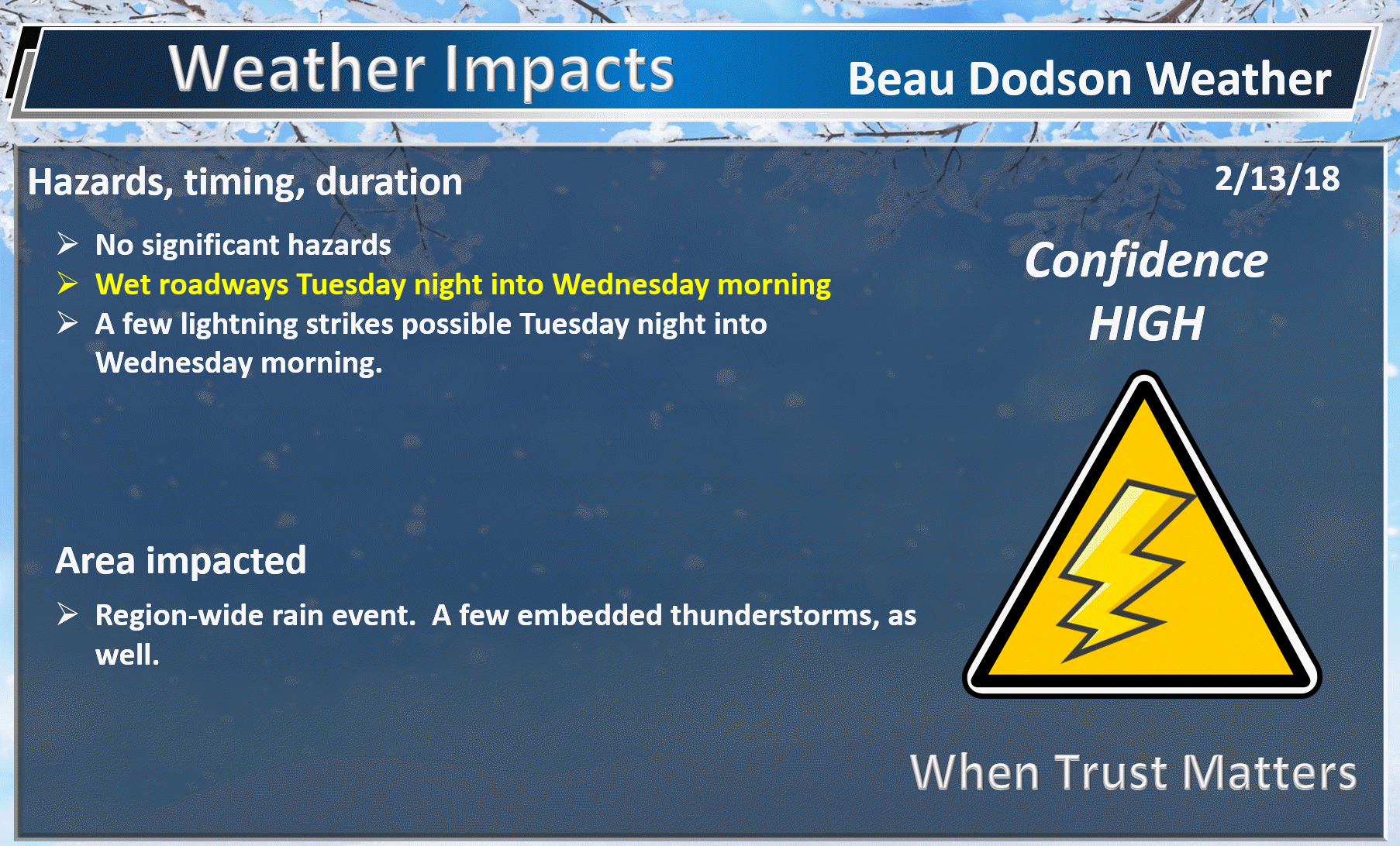
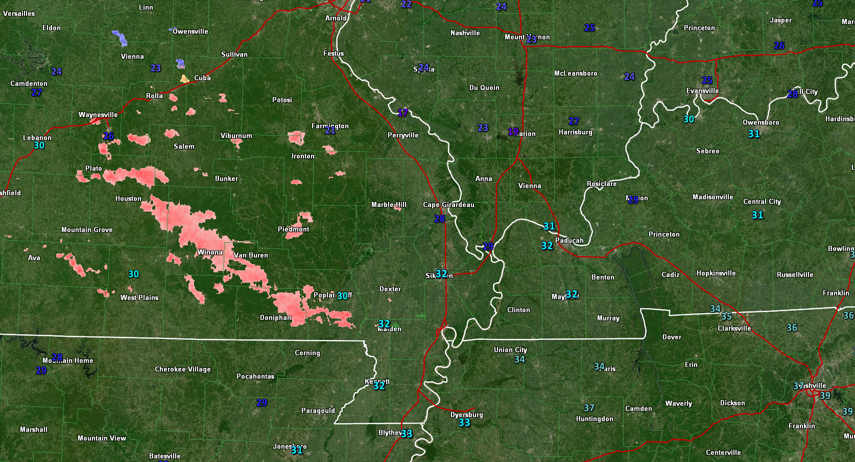
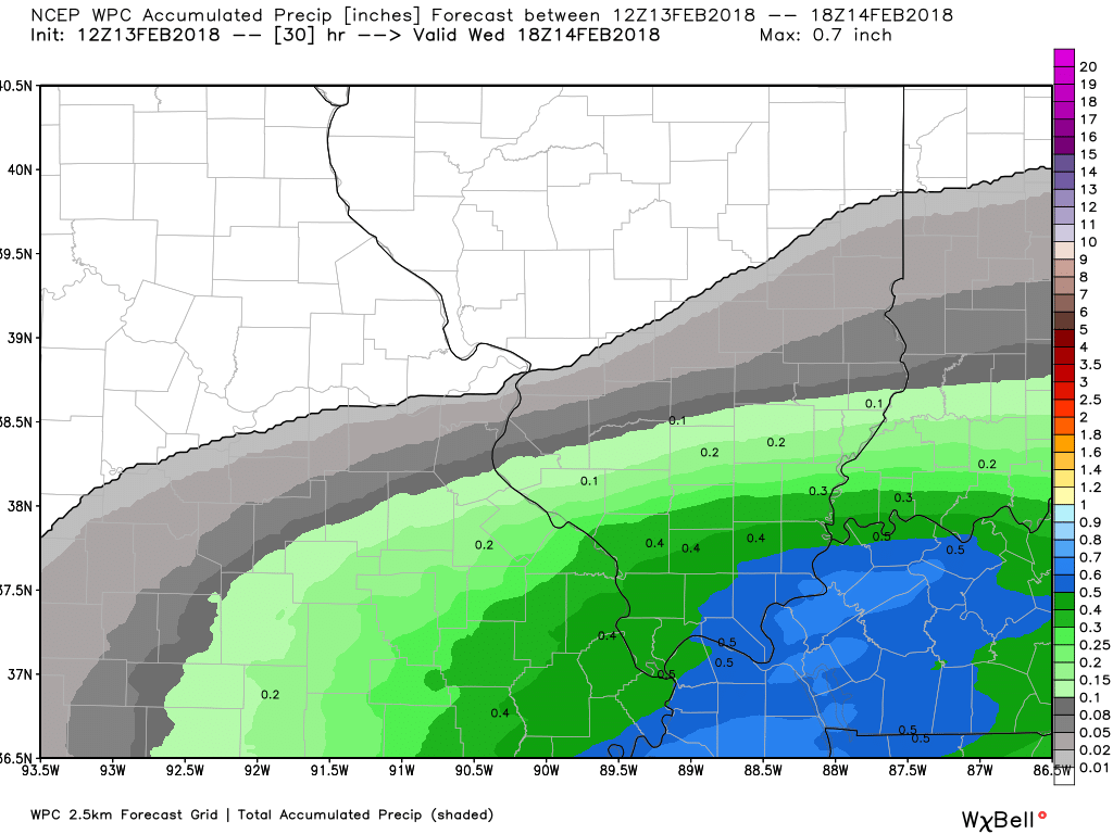
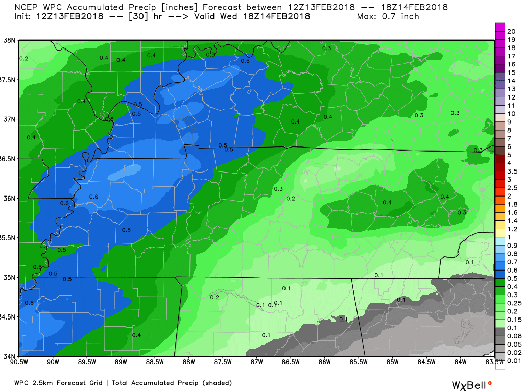
The big weather story over the next few days will be rain chances. Rain will develop from south to north tonight. A few lightning bolts are possible after midnight.
Rainfall totals between tonight and tomorrow morning will likely range from 0.30″ to 0.60″ with pockets of slightly higher totals possible.
Here is the latest WPC rainfall for the northwest and the southeast half of the region.
Click images to enlarge
.
.
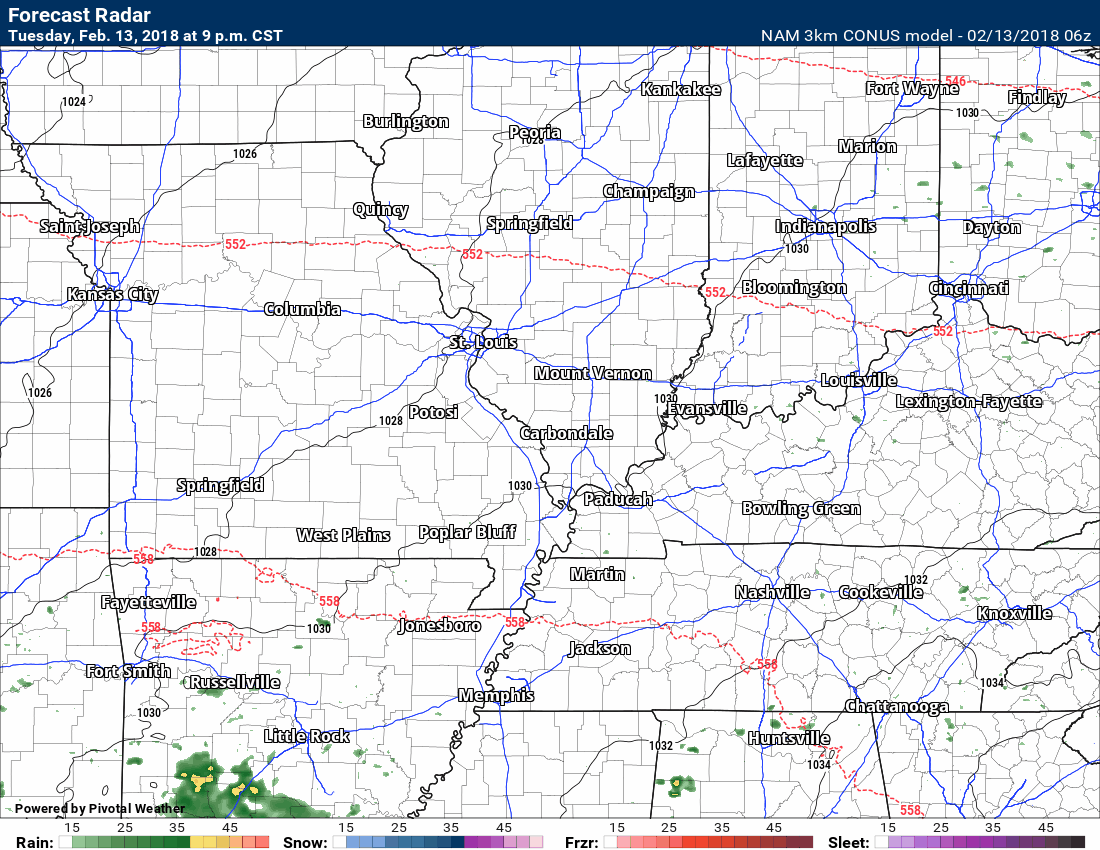
Rain showers will taper tomorrow morning and end by the early afternoon. Precipitation will end from west to east.
Here is the future-cast radar from the high resolution NAM 3K model. This is showing you what radar might look like over the next 24 to 36 hours.
Those yellow and orange colors represent heavier downpours. Perhaps a few thunderstorms.
Time stamp upper left
.
.
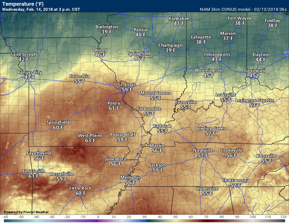
Wednesday will be milder, as well. Even with the clouds and rain, temperatures should rise into the 50’s.
Wednesday 3 PM Temperature map
.
.
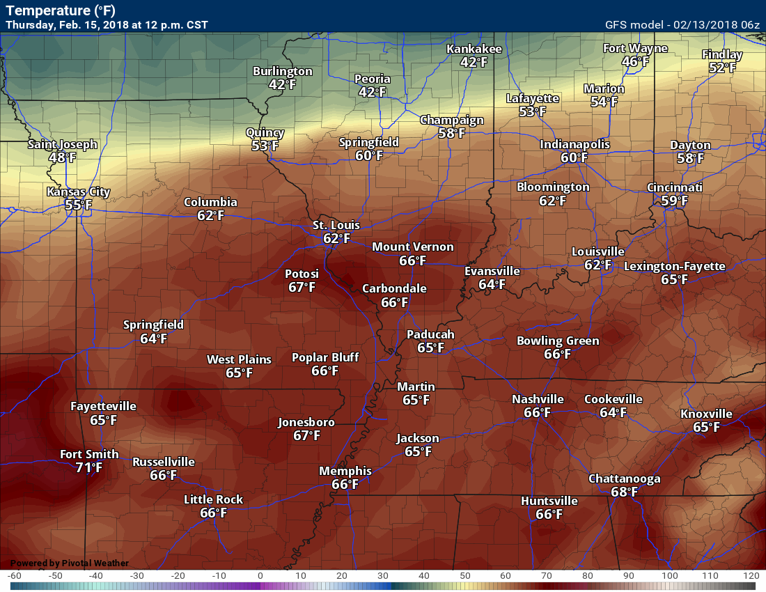
Our next weather maker will arrive Thursday night. A strong cold front will enter the region from the north and west. This front will help produce widespread showers and perhaps some thunderstorms. Severe weather appears unlikely.
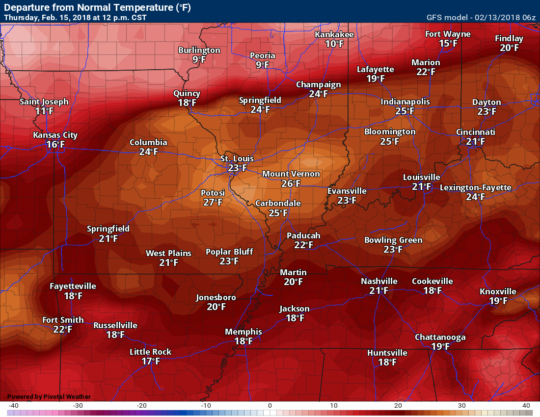
Temperatures on Thursday will feel more like spring than February. Here is the Thursday high temperature map.
.
.
Here is the 24 temperature change map from 12 PM Wednesday to 12 PM Thursday.
How many degrees warmer will it be?
.
.
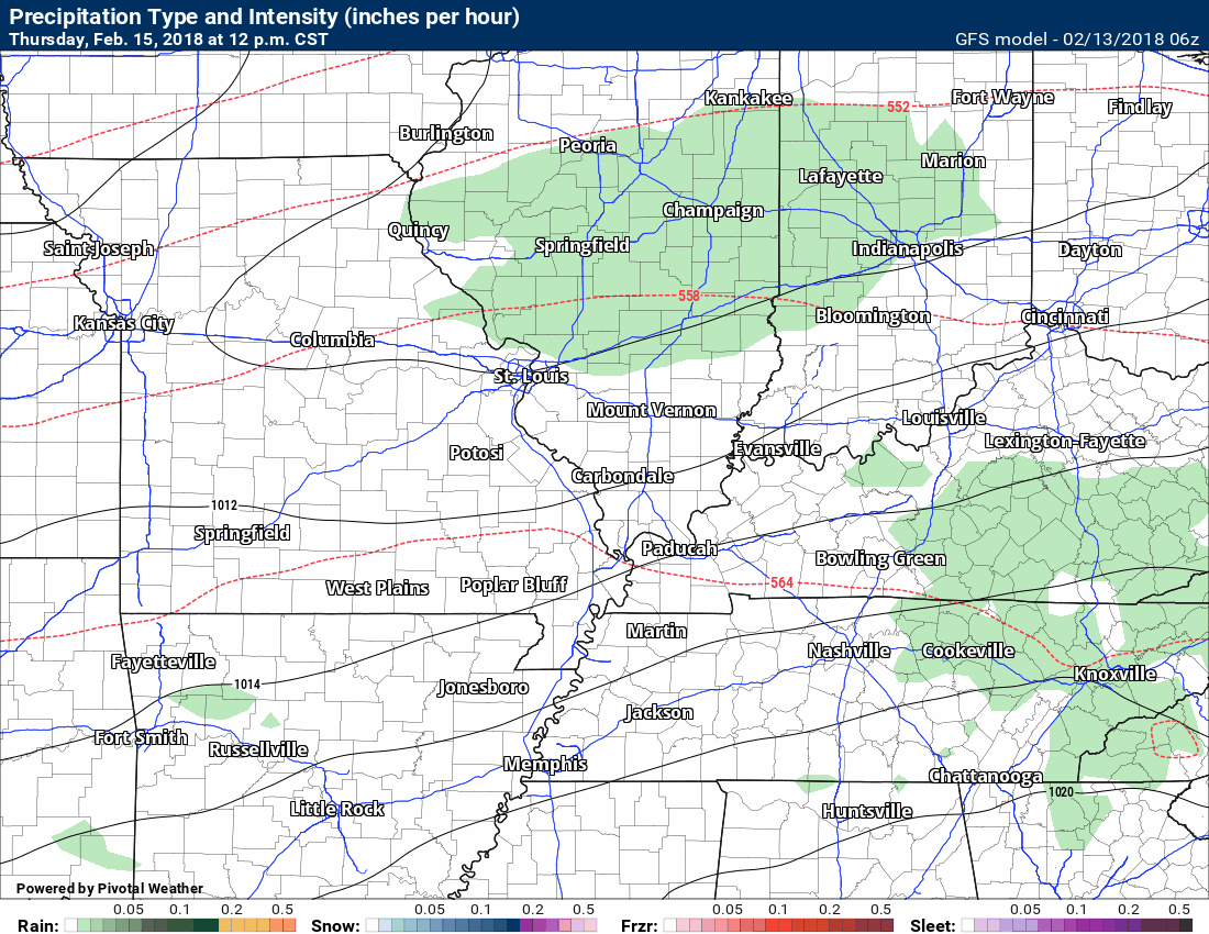
Here is the future-cast radar for that event, as well.
Some moderate rain is possible Thursday night into Friday morning, as well.
Green represents rain. Dark green is moderate rain. Blue is snow.
The precipitation may end as a brief period of snow showers. At this time, accumulating snow appears unlikely. Monitor updates.
.
.
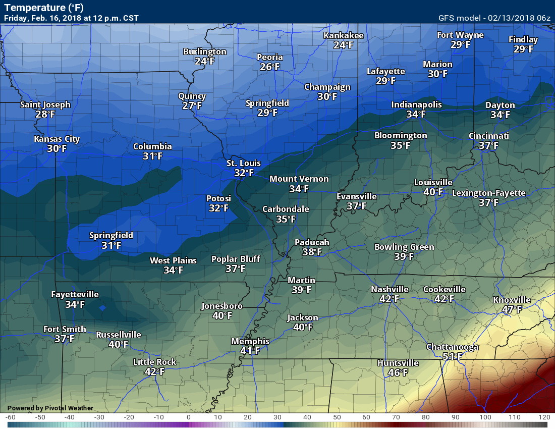
Temperatures Friday will be quite a bit colder. Here is the 12 PM Friday temperature map.
.
.
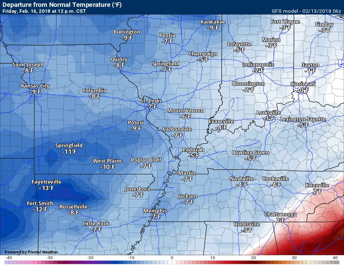
Let’s look at the 24 hour temperature change from 12 PM Thursday to 12 PM Friday
How many degrees colder will it be?
.
.
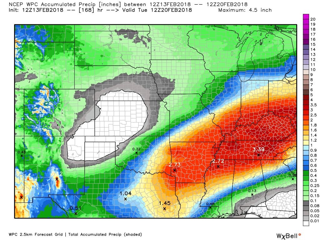
Rainfall totals between Tuesday night and Friday.
Here is the northwest and southeast view.
Click images to enlarge
.
.
Confidence in the foreacst decreases as we move into late Friday night through Sunday night.
I am closely monitoring a wave/disturbance along the cold front. This disturbance could cause the cold front to slow down or even stall in or near our region. If this happens, then additional precipitation chances will arrive late Friday night into Saturday night. It might be cold enough for a wintry mix.
Confidence on the front stalling, at least for now, is low. Monitor updated forecasts.
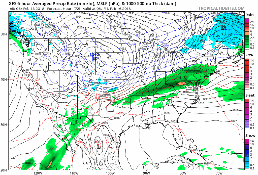
Here is the GFS model radar animation for Friday night into Sunday. Notice the second wave of precipitation.
Time stamp upper left. This is Zulu time. That means 12z is 6 am. 18z is 12 pm. 0z is 6 pm. 06z is 12 am.
You can see the wave of precipitation bulge northward late Friday night into Saturday. Confidence on this second disturbance is low.
Green is rain. Blue is snow.
.
.
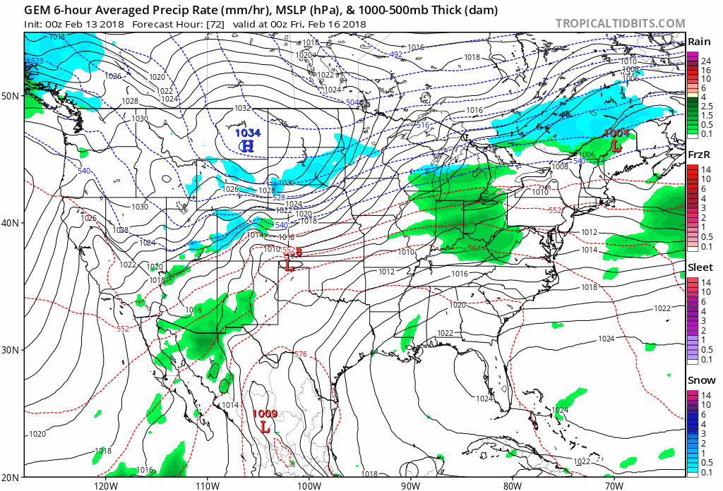
Here is the GEM model for the same time period. Future-cast radar.
The GEM is even more impressive with the second wave. It develops a full fledged storm system with an area of low pressure. This needs to be monitored. With colder air near our region late Friday night into Saturday, there could be a wintry mix. Confidence is low.
.
.
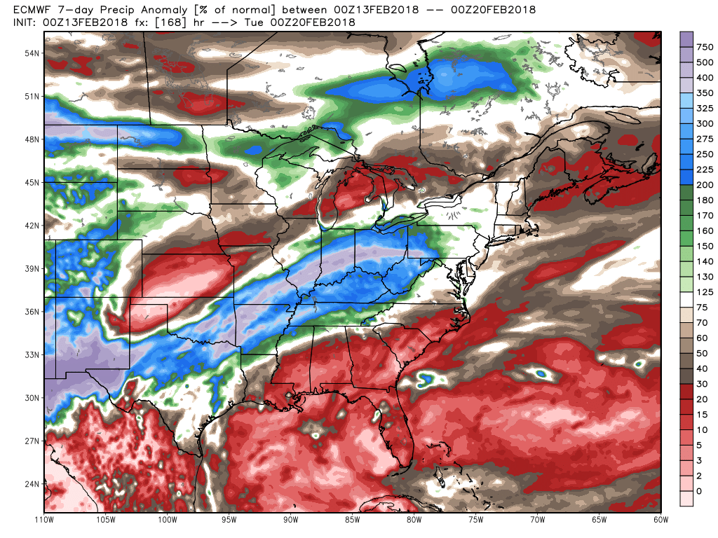
We continue with the active pattern into next week.
Let me show you some more maps.
Here is the EC model guidance precipitation anomaly for the next seven days. WELL above normal.
This is the % of normal precipitation. The EC guidance is showing 300 to 500 percent of normal rainfall. That would mean sevearl inches of rain across our region between now and next Tuesday.
Portions of the region remain in drought. This is especially true for Missouri.
.
.
Here is the seven day WPC rainfall forecast.
.
.
The preliminary summer forecast has been posted on the subscription website. Subscribe at www.beaudodsonweather.com
Summer outlook – Click here
.


We offer regional radars and local city radars – if a radar does not update then try another one. Occasional browsers need their cache cleared. You may also try restarting your browser. This will usually fix any problems.
During the winter you can track snow and ice by clicking the winterize button on the local city view interactive radars.
You may email me at beaudodson@usawx.com
Interactive Weather Radar Page. Choose the city nearest your location: Click this link
National interactive radar: Click this link.