A general spring and summer outlook has been posted. More details will be posted over time.
Bonus maps and videos have been updated.
Link to the long range outlooks (Scroll down to the 2nd post at this link for the latest long range outlook) and videos (for subscribers) – Click here
You haven’t subscribed? Subscribe at www.beaudodsonweather.com
Monthly operating costs for Weather Talk can top $2000.00. Your $3 subscription helps pay for those costs. I work for you.
.

.
February 12, 2018
Monday Forecast Details
Forecast: Mostly sunny. Any clouds will clear and move off to the east. Cold.
Temperatures: MO ~ 38 to 44 IL ~ 38 to 44 KY ~ 40 to 45
What is the chance of precipitation? MO ~ 0% IL ~ 0% KY ~ 0% TN ~ 0%
Coverage of precipitation: None anticipated
Wind chill values: 20 to 30
Accumulating snow or ice: No
Winds: North and northeast winds 6 to 12 mph with gusts to 18 mph
What impacts are anticipated from the weather? None
My confidence in the forecast verifying: High
Is severe weather expected? No
The NWS defines severe weather as 58 mph wind or great, 1″ hail or larger, and/or tornadoes
Should I cancel my outdoor plans? No
.
Monday Night Forecast Details:
Forecast: Mostly clear. Cold. Patchy fog possible.
Temperatures: MO ~ 20 to 25 IL ~ 18 to 24 KY ~ 22 to 26
What is the chance of precipitation? MO ~ 0% IL ~ 0% KY ~ 0% TN ~ 0%
Coverage of precipitation: None
Wind chill values: 22 to 30
Accumulating snow or ice: No
Winds: East and northeast winds 5 to 10 mph
What impacts are anticipated from the weather? None
My confidence in the forecast verifying: High
Is severe weather expected? No
The NWS defines severe weather as 58 mph wind or great, 1″ hail or larger, and/or tornadoes
Should I cancel my outdoor plans: No
.
February 13, 2018
Tuesday Forecast Details
Forecast: Intervals of clouds and sun. A few morning flurries over southeast Missouri. A few sprinkles possible over southwest Illinois, far western Kentucky, and northwest Tennessee. Cool.
Temperatures: MO ~ 45 to 50 IL ~ 45 to 52 KY ~ 46 to 54
What is the chance of precipitation? MO ~ 30% morning IL ~ 20% KY ~ 20% TN ~20%
Coverage of precipitation: Spotty over southeast Missouri
Wind chill values: N/A
Accumulating snow or ice: No, but a few morning flurries possible over southeast Missouri.
Winds: Winds becoming variable at 4 to 8 mph. Winds become southeast as the day wears on.
What impacts are anticipated from the weather? None.
My confidence in the forecast verifying: High
Is severe weather expected? No
The NWS defines severe weather as 58 mph wind or great, 1″ hail or larger, and/or tornadoes
Should I cancel my outdoor plans? No
.
Tuesday Night Forecast Details:
Forecast: Mostly cloudy. Rain chances will increase through the night. A few thunderstorms possible.
Temperatures: MO ~ 38 to 44 IL ~ 38 to 44 KY ~ 38 to 44
What is the chance of precipitation? MO ~ 70% IL ~ 70% KY ~ 90% TN ~ 100%
Coverage of precipitation: Becoming widespread
Wind chill values: 30 to 40
Accumulating snow or ice: No
Winds: South and southwest at 4 to 8 mph.
What impacts are anticipated from the weather? Wet roadways
My confidence in the forecast verifying: High
Is severe weather expected? No
The NWS defines severe weather as 58 mph wind or great, 1″ hail or larger, and/or tornadoes
Should I cancel my outdoor plans: No
.
February 14, 2018
Wednesday Forecast Details
Forecast: Mostly cloudy. Morning rain likely. A rumble of thunder possible. Rain chances will decrease during the mid morning to mid afternoon time frame.
Temperatures: MO ~ 56 to 62 IL ~ 56 to 62 KY ~ 56 to 62
What is the chance of precipitation? MO ~ 60% IL ~ 60% KY ~ 70% TN ~ 70%
Coverage of precipitation: Scattered to perhaps widespread early in the day. Diminishing as the day wears on.
Wind chill values: N/A
Accumulating snow or ice: No
Winds: South and southwest at 7 to 14 mph with gusts to 20
What impacts are anticipated from the weather? Wet roadways.
My confidence in the forecast verifying: High
Is severe weather expected? No
The NWS defines severe weather as 58 mph wind or great, 1″ hail or larger, and/or tornadoes
Should I cancel my outdoor plans? Have a plan B and monitor updates.
.
Wednesday Night Forecast Details:
Forecast: Cloudy. Mild. Breezy. Scattered showers possible.
Temperatures: MO ~ 53 to 56 IL ~ 52 to 56 KY ~ 54 to 58
What is the chance of precipitation? MO ~ 50% IL ~ 50% KY ~ 60% TN ~ 50%
Coverage of precipitation: Scattered
Wind chill values: N/A
Accumulating snow or ice: No
Winds: South and southwest at 10 to 20 mph with gusts above 20 mph.
What impacts are anticipated from the weather? Wet roadways
My confidence in the forecast verifying: Medium
Is severe weather expected? No
The NWS defines severe weather as 58 mph wind or great, 1″ hail or larger, and/or tornadoes
Should I cancel my outdoor plans: Have a plan B and monitor updates.
.
February 15, 2018
Thursday Forecast Details
Forecast: Mostly cloudy. A chance of showers. Mild. Breezy.
Temperatures: MO ~ 64 to 66 IL ~ 62 to 66 KY ~ 64 to 68
What is the chance of precipitation? MO ~ 40% IL ~ 40% KY ~ 40% TN ~ 40%
Coverage of precipitation: Scattered
Wind chill values: N/A
Accumulating snow or ice: No
Winds: South and southwest at 10 to 20 mph with gusts to 30 mph
What impacts are anticipated from the weather? Wet roadways.
My confidence in the forecast verifying: Medium
Is severe weather expected? No
The NWS defines severe weather as 58 mph wind or great, 1″ hail or larger, and/or tornadoes
Should I cancel my outdoor plans? Have a plan B and monitor updates.
.
Thursday Night Forecast Details:
Forecast: Cloudy. Turning colder. Windy. Rain. Falling temperatures.
Temperatures: MO ~ 34 to 40 IL ~ 34 to 38 KY ~ 38 to 46 (warmest towards Hopkinsville vs Paducah)
What is the chance of precipitation? MO ~ 60% IL ~ 60% KY ~ 60% TN ~ 60%
Coverage of precipitation: Perhaps widespread.
Wind chill values: N/A
Accumulating snow or ice: No
Winds: South and southwest at 8 to 16 mph and gusty. Winds becoming west and northwest at 10 to 20 mph and gusty.
What impacts are anticipated from the weather? Wet roadways
My confidence in the forecast verifying: Medium
Is severe weather expected? No
The NWS defines severe weather as 58 mph wind or great, 1″ hail or larger, and/or tornadoes
Should I cancel my outdoor plans: Have a plan B and monitor updates.
.
February 16, 2018
Friday Forecast Details
Forecast: Mostly cloudy. Colder. Rain showers. Rain may end as light snow showers.
Temperatures: MO ~ 44 to 48 IL ~ 44 to 48 KY ~ 44 to 48
What is the chance of precipitation? MO ~ 40% IL ~ 40% KY ~ 40% TN ~ 40%
Coverage of precipitation: Scattered to perhaps widespread
Wind chill values: N/A
Accumulating snow or ice: Most likely no, but monitor updates.
Winds: North and northwest at 10 to 20 mph.
What impacts are anticipated from the weather? Wet roadways.
My confidence in the forecast verifying: Medium
Is severe weather expected? No
The NWS defines severe weather as 58 mph wind or great, 1″ hail or larger, and/or tornadoes
Should I cancel my outdoor plans? Have a plan B and monitor updates.
.
Friday Night Forecast Details:
Forecast: Mostly cloudy. Colder. A flurry possible.
Temperatures: MO ~ 24 to 28 IL ~ 24 to 28 KY ~ 24 to 28
What is the chance of precipitation? MO ~ 30% IL ~ 30% KY ~ 30% TN ~ 30%
Coverage of precipitation:
Wind chill values: N/A
Accumulating snow or ice: Most likely no, but monitor updates.
Winds: North and northeast at 5 to 10 mph with gusts to 14 mph
What impacts are anticipated from the weather? Wet roadways. Monitor snow chances.
My confidence in the forecast verifying: Medium
Is severe weather expected? No
The NWS defines severe weather as 58 mph wind or great, 1″ hail or larger, and/or tornadoes
Should I cancel my outdoor plans: Have a plan B and monitor updates.
.
February 17, 2018
Saturday Forecast Details
Forecast: Mostly sunny.
Temperatures: MO ~ 44 to 48 IL ~ 44 to 48 KY ~ 44 to 48
What is the chance of precipitation? MO ~ 0% IL ~ 0% KY ~ 0% TN ~ 0%
Coverage of precipitation: None
Wind chill values: N/A
Accumulating snow or ice: No
Winds: North and northwest at 7 to 14 mph. Winds becoming variable late in the day.
What impacts are anticipated from the weather? None
My confidence in the forecast verifying: Medium
Is severe weather expected? No
The NWS defines severe weather as 58 mph wind or great, 1″ hail or larger, and/or tornadoes
Should I cancel my outdoor plans? No
.
Saturday Night Forecast Details:
Forecast: Mostly clear early. Some increase in clouds after midnight.
Temperatures: MO ~ 26 to 34 IL ~ 26 to 34 KY ~ 26 to 34
What is the chance of precipitation? MO ~ 0% IL ~ 0% KY ~ 0% TN ~ 0%
Coverage of precipitation: None
Wind chill values: N/A
Accumulating snow or ice: No
Winds: North and northeast at 5 to 10 mph with gusts to 14 mph
What impacts are anticipated from the weather? None
My confidence in the forecast verifying: Medium
Is severe weather expected? No
The NWS defines severe weather as 58 mph wind or great, 1″ hail or larger, and/or tornadoes
Should I cancel my outdoor plans: No
.
February 18, 2018
Sunday Forecast Details
Forecast: Increasing clouds. Isolated showers possible. A bit milder.
Temperatures: MO ~ 48 to 54 IL ~ 48 to 54 KY ~ 48 to 54
What is the chance of precipitation? MO ~ 30% IL ~ 30% KY ~ 30% TN ~ 30%
Coverage of precipitation: Scattered
Wind chill values: N/A
Accumulating snow or ice: No
Winds: South and southwest winds at 6 to 12 mph
What impacts are anticipated from the weather? Wet roadways
My confidence in the forecast verifying: Medium
Is severe weather expected? No
The NWS defines severe weather as 58 mph wind or great, 1″ hail or larger, and/or tornadoes
Should I cancel my outdoor plans? No, but monitor updates.
.
Sunday Night Forecast Details:
Forecast: Cloudy. Scattered showers.
Temperatures: MO ~ 36 to 44 IL ~ 36 to 44 KY ~ 36 to 44
What is the chance of precipitation? MO ~ 40% IL ~ 40% KY ~ 40% TN ~ 40%
Coverage of precipitation: Scattered
Wind chill values: N/A
Accumulating snow or ice: No
Winds: South and southwest winds at 6 to 12 mph becoming west.
What impacts are anticipated from the weather? Wet roadways.
My confidence in the forecast verifying: Medium
Is severe weather expected? No
The NWS defines severe weather as 58 mph wind or great, 1″ hail or larger, and/or tornadoes
Should I cancel my outdoor plans: No, bu monitor updates.
.
Interactive Weather Radar Page. Choose the city nearest your location: Click this link.
.

.
Monday through Thursday night: Winter weather is not anticipated.
Friday afternoon and night: Snow flurries are possible as the rain winds down.
.

.
The National Weather Service definition of a severe thunderstorm is one that produces quarter size hail or larger, 58 mph winds or greater, and/or a tornado.
Now through Friday: Severe weather is not in the forecast. Lightning is possible Tuesday night and Wednesday and again Thursday/Thursday night.
.

.
The daily outlook can be found at the bottom of this post.
Interactive Weather Radar Page. Choose the city nearest your location: Click this link.
Forecast:
HIGHLIGHTS
- A quiet 24 to 36 hours ahead of us
- Warming trend through Thursday
- Several chances of rain this week
- Cold snap Friday and Saturday
High confidence today through Thursday afternoon.
I hope everyone had a nice weekend. We experienced several rounds of freezing rain, sleet, and snow. Some picked up enough to cause problems and others missed out entirely.
We will begin the work-week cool, but nothing extreme. Below normal temperatures. Winds will begin to turn out of the south over the next 24 hours and that will mark the beginning of a significant warming trend. We will even push into above normal temperatures as the week wears on.
Tuesday will deliver widespread 40’s over the northern half of the region and 50’s south. Everyone will be in the 50’s on Wednesday and perhaps even some 60’s.
Thursday will be the warmest day with widespread 60’s! Yes, widespread 60’s!
Showers will accompany the surge of warmer air. Typical for this time of the year. Scattered showers and perhaps thunderstorms will develop Tuesday night into Wednesday morning. This will be along a warm front that will push northward through our region.
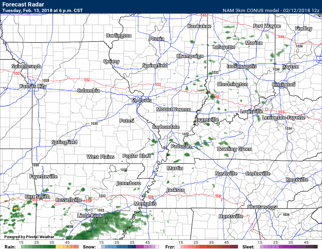
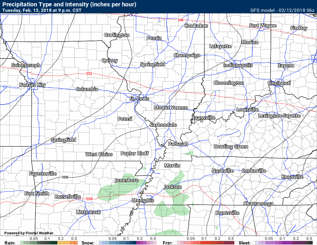
Let’s take a look at the high resolution NAM model guidance. This is the future-cast radar.
Spotty showers and perhaps thunderstorms as we move into Tuesday evening and night.
Time stamp upper left.
.
.
A better organized system develops Wednesday night into Thursday night. An area of low pressure will form well to our west. This system will eventually move northeast into the Great Lakes by Thursday night and Friday.
A cold front will accompany this system. Warm air ahead of the cold front will help showers and perhaps thunderstorms develop in our region Thursday and Thursday night. The best chance of rain may end up being Thursday afternoon and night.
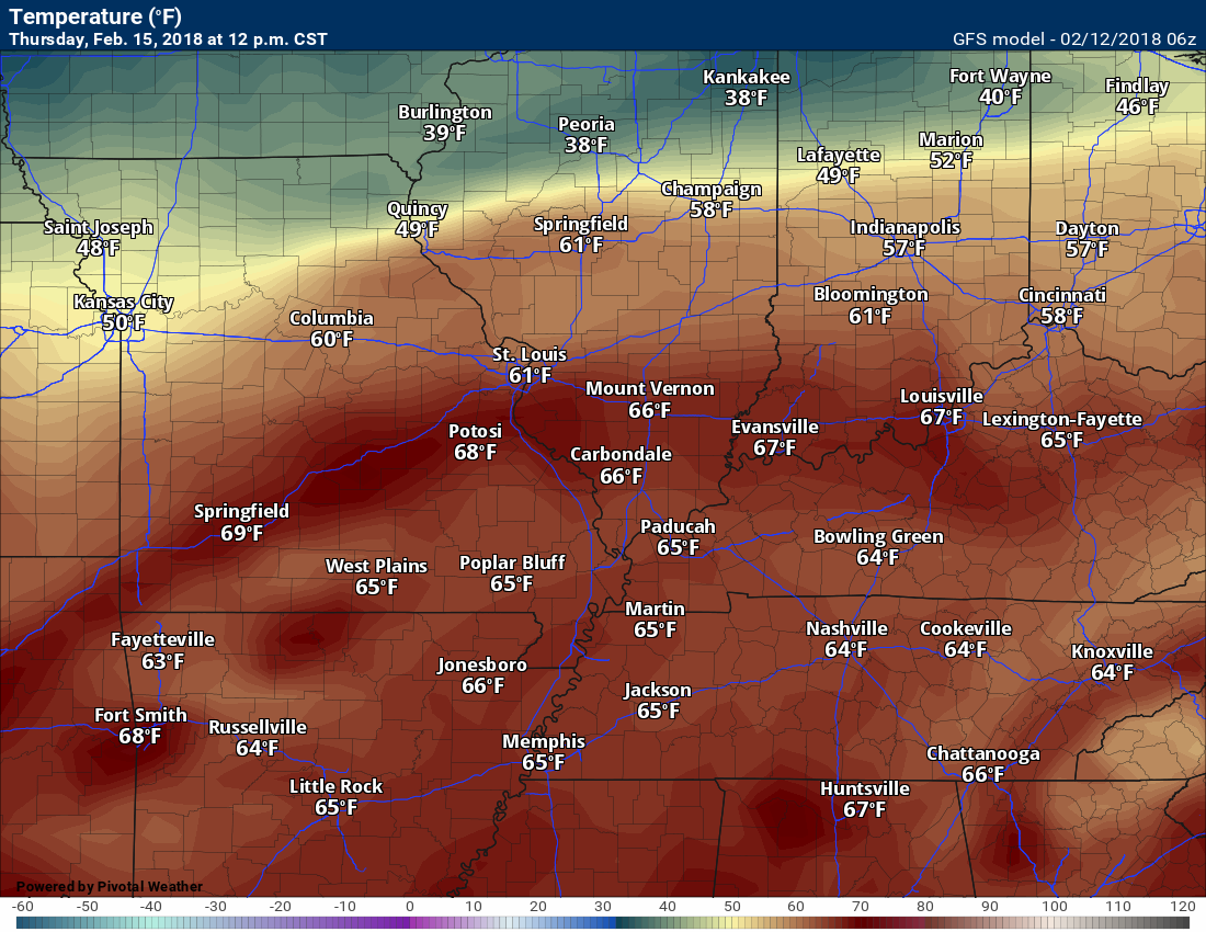
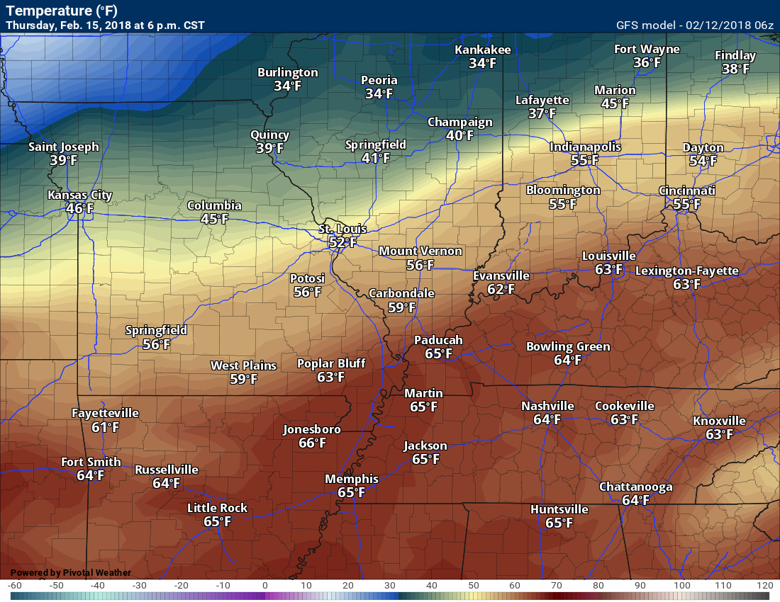
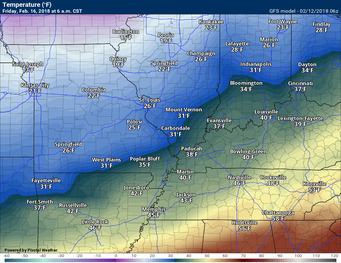
Check out the surge of warm air ahead of the cold front.
12 PM Thursday
.
.
6 PM Thursday
.
.
6 AM Friday. Colder air wraps back around the system into our local area.
.
.
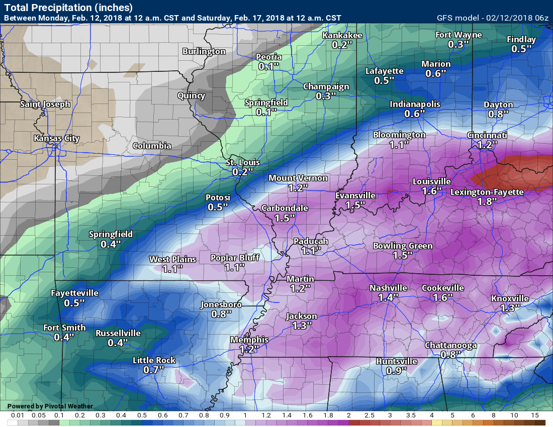
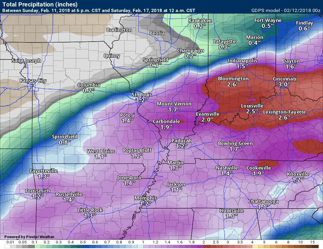
Models have done horribly lately with QPF (rainfall totals). It does appear this should be a widespread rain event. Rain totals of 0.60″ to 1.20″ are possible. Models are showing one to three inches. I will monitor that part of the forecast. Portions of the region do need rain.
Here is the GFS model and GEM model guidance rainfall forecast totals for the Thursday/Friday system.
GFS model
.
.
Canadian GEM model rainfall forecast
.
.
Rain is forecast to end on Friday as colder air filters into the region. There could be a quick change-over to a wintry mix as the precipitation ends. Typically, without another wave on the front, this does not result in much of the way of measurable precipitation. If the system were to slow, then that portion of the forecast would change. Let’s keep an eye on it. For now, this looks like a rain event ending perhaps as some sleet pellets or light flurries.
The region will dry out on Friday into Saturday. Another quick moving system may bring rain back into the region as early as Sunday and Sunday night.
Let’s look at a couple of charts.
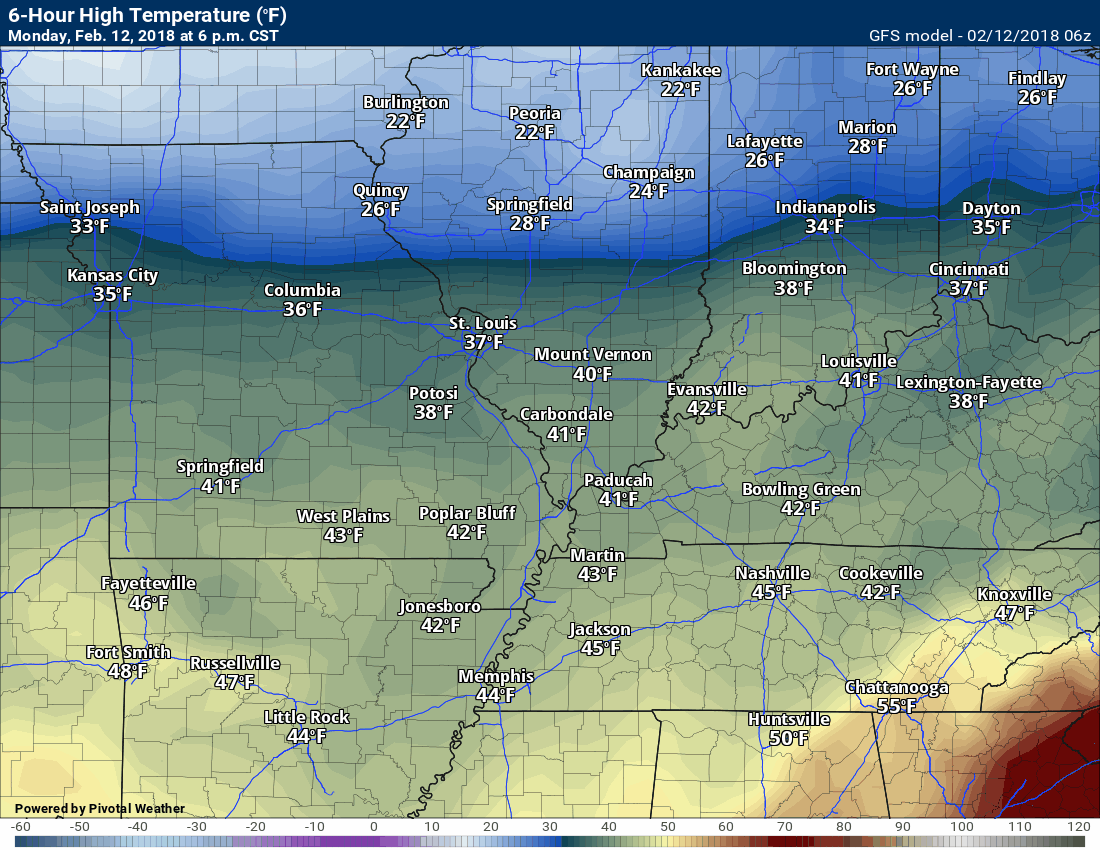
Here is the high temperature forecast from the GFS guidance. This takes us into the weekend.
Time stamp upper left. Notice that surge of warm air ahead of the cold front on Thursday!
.
.
Here is the future-cast radar from the GFS guidance. Green would be rain.
.
.
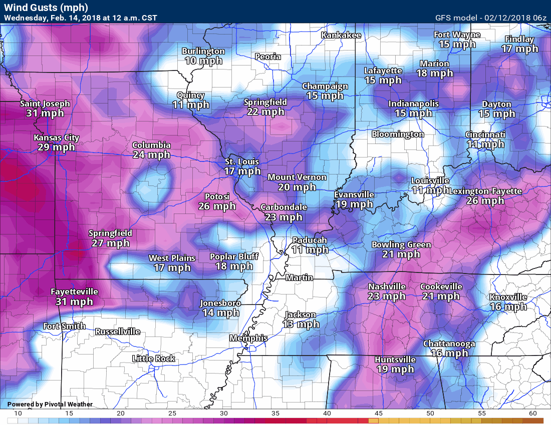
Here is the wind gust map. We will have periodic gusty winds this week.
.
.
The preliminary summer forecast has been posted on the subscription website. Subscribe at www.beaudodsonweather.com
Summer outlook – Click here
.


We offer regional radars and local city radars – if a radar does not update then try another one. Occasional browsers need their cache cleared. You may also try restarting your browser. This will usually fix any problems.
During the winter you can track snow and ice by clicking the winterize button on the local city view interactive radars.
You may email me at beaudodson@usawx.com
Interactive Weather Radar Page. Choose the city nearest your location: Click this link
National interactive radar: Click this link.