LONG RANGE OUTLOOKS/Videos/Graphics
February and March outlooks have been updated.
Bonus maps and videos have been updated.
Link to the long range outlooks and videos (for subscribers) – Click here
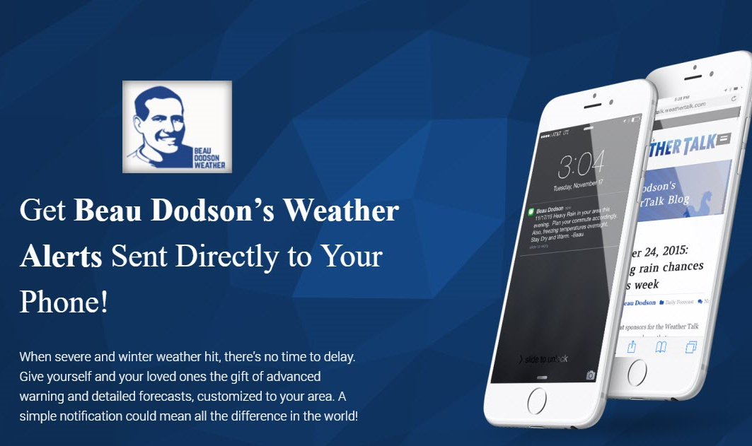
Subscribe at www.beaudodsonweather.com
Monthly costs to run Weather Talk can top $2000.00
Please consider subscribing!
Here are my monthly out of pocket costs to deliver you the weather.
.

.
Do you want more? How about short and long range outlooks, videos, and more detailed analysis!
Subscribe at www.beaudodsonweather.com
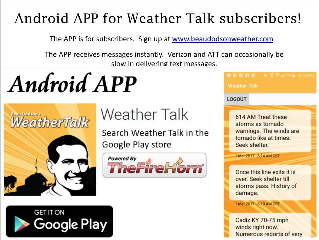
Once subscribed you can choose from four different app/text messages!
.
.
Be sure and download the app (subscribers). The app receives the messages much faster than regular text messaging (same messages, but faster).
.

.

.
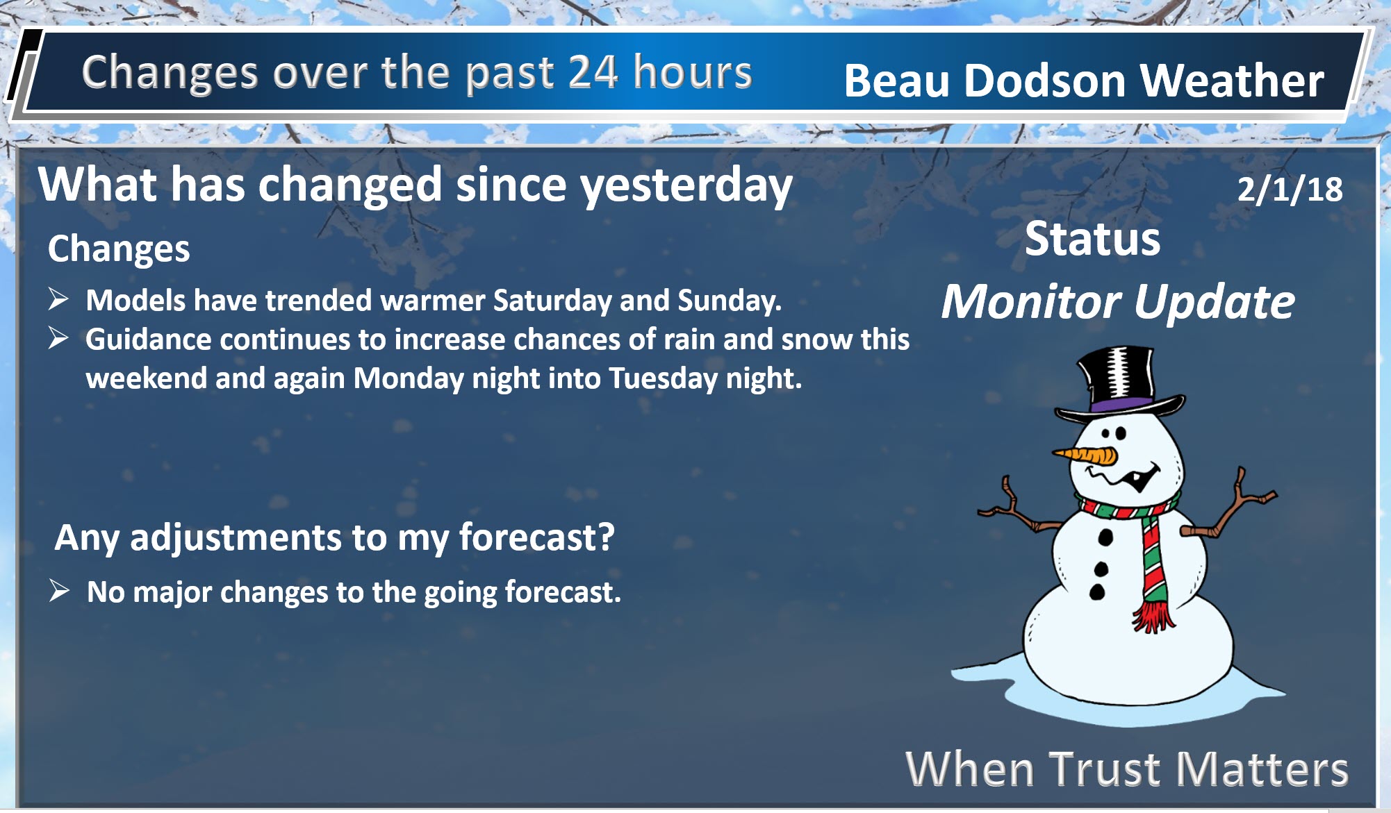
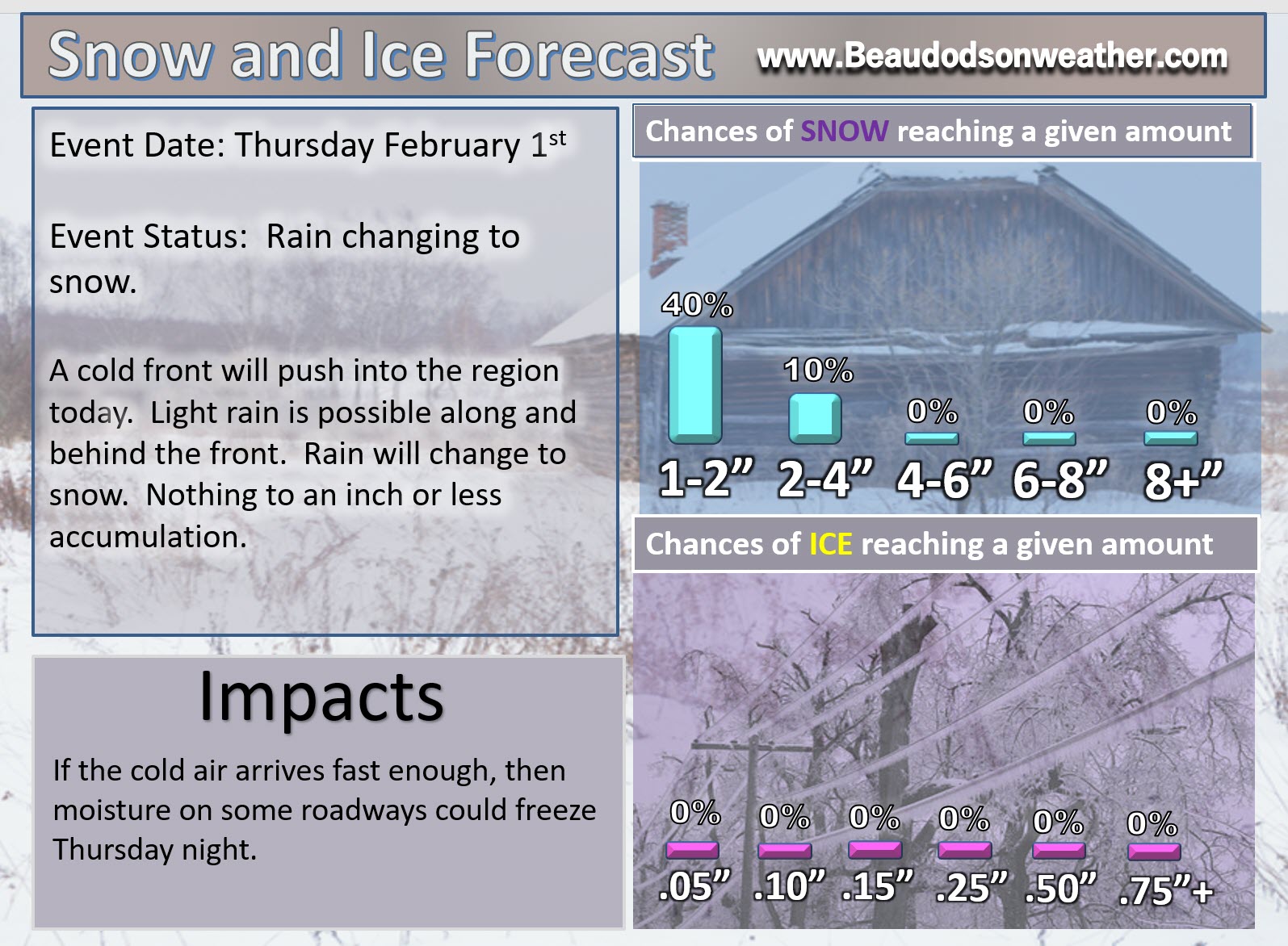
February 1, 2018
Thursday Forecast Details
Forecast: Mostly cloudy. Light rain possible over extreme southern Illinois, far southeast Missouri, western Kentucky, and western Tennessee. Lesser rain chances as you move north of Cape Girardeau towards Harrisburg. Some areas may remain dry. Turning colder during the afternoon. Rain may mix with or change to snow showers. No accumulation to less than an inch accumulation. Best chance of a little snow accumulation would be across southeast Illinois and western Kentucky.
Temperatures: MO ~ 42 to 46 temperatures may fall during the afternoon IL ~ 40 to 45 temperatures may fall during the afternoon KY ~ 46 to 48 with falling temperatures during the afternoon and evening
What is the chance of precipitation? MO ~ 30% IL ~ 40% KY ~ 60% TN ~ 60%
Coverage of precipitation: Isolated northern counties. Scattered to perhaps a band of light rain across extreme southern Illinois/far southeast Missouri into Kentucky/Tennessee
Wind chill values: 25 to 38
Accumulating snow or ice: No snow accumulation to less than an inch of snow.
Winds: Winds becoming north and northwest behind the cold front (northern portions of the area). Wind speeds of 6 to 12 mph with gusts to 25 mph.
What impacts are anticipated from the weather? Wet roadways.
My confidence in the forecast verifying: High
Is severe weather expected? No
The NWS defines severe weather as 58 mph wind or great, 1″ hail or larger, and/or tornadoes
Should I cancel my outdoor plans? Have a plan B
.
Thursday Night Forecast Details:
Forecast: Cloudy early. Light flurries or snow showers possible across mostly western Kentucky and northwest Tennessee. The rest of the area should dry out fairly quick. Monitor moisture on roadways as temperatures fall into the upper teens and lower 20’s (some slick spots possible). Clearing and colder overnight.
Temperatures: MO ~ 14 to 20 IL ~ 10 to 16 (colder near Mt Vernon vs Metropolis) KY ~ 18 to 22
What is the chance of precipitation? MO ~ 10% IL ~ 20% KY ~ 30% TN ~ 30%
Coverage of precipitation: Ending.
Wind chill values: 2 to 12
Accumulating snow or ice: No snow accumulation to less than an inch or snow accumulation. Watch standing water areas overnight, they may freeze.
Winds: North and northwest at 10 to 20 mph
What impacts are anticipated from the weather? Wet roadways. Monitor moisture on roads overnight. Moisture could freeze.
My confidence in the forecast verifying: High
Is severe weather expected? No
The NWS defines severe weather as 58 mph wind or great, 1″ hail or larger, and/or tornadoes
Should I cancel my outdoor plans: No, but monitor updates.
.
February 2, 2018
Friday Forecast Details
Forecast: Mostly sunny. Some passing clouds. Much colder.
Temperatures: MO ~ 28 to 32 IL ~ 26 to 34 KY ~ 28 to 34
What is the chance of precipitation? MO ~ 0% IL ~ 0% KY ~ 0% TN ~ 0%
Coverage of precipitation: None
Wind chill values: 20 to 30
Accumulating snow or ice: No
Winds: North and northwest at 5 to 10 mph
What impacts are anticipated from the weather? None
My confidence in the forecast verifying: High
Is severe weather expected? No
The NWS defines severe weather as 58 mph wind or great, 1″ hail or larger, and/or tornadoes
Should I cancel my outdoor plans? No
.
Friday Night Forecast Details:
Forecast: Mostly clear early and then increasing clouds late. Cold. Snow flurries possible after 2 am.
Temperatures: MO ~ 18 to 24 IL ~ 16 to 22 KY ~ 18 to 24
What is the chance of precipitation? MO ~ 10% IL ~ 10% KY ~ 10% TN ~ 10%
Coverage of precipitation: None to isolated.
Wind chill values: 10 to 20
Accumulating snow or ice: No
Winds: Light and variable winds. Winds becoming south.
What impacts are anticipated from the weather? Most likely none.
My confidence in the forecast verifying: High
Is severe weather expected? No
The NWS defines severe weather as 58 mph wind or great, 1″ hail or larger, and/or tornadoes
Should I cancel my outdoor plans: No
.
February 3, 2018
Saturday Forecast Details
Forecast: Becoming mostly cloudy. Isolated rain or rain / snow showers developing across southeast Missouri and spreading eastward during evening hours.
Temperatures: MO ~ 36 to 42 IL ~ 36 to 42 KY ~ 38 to 44
What is the chance of precipitation? MO ~ 40% IL ~ 20% KY ~ 30% TN ~ 30%
Coverage of precipitation: Scattered during the late afternoon and evening
Wind chill values: 30 to 40
Accumulating snow or ice: Monitor updates
Winds: South at 6 to 12 mph
What impacts are anticipated from the weather? Wet roadways. Monitor the snow forecast.
My confidence in the forecast verifying: High
Is severe weather expected? No
The NWS defines severe weather as 58 mph wind or great, 1″ hail or larger, and/or tornadoes
Should I cancel my outdoor plans? Have a plan B and monitor radars.
.
Saturday Night Forecast Details:
Forecast: Mostly cloudy. Rain or rain/snow mix. Rain may change to snow at times. Temperatures will be marginal for snow accumulation. This may end up being mostly a rain event, but confidence remains low. Check back frequently for updates.
Temperatures: MO ~ 30 to 35 IL ~ 30 to 35 KY ~ 32 to 36
What is the chance of precipitation? MO ~ 70% IL ~ 70% KY ~ 70% TN ~ 70%
Coverage of precipitation: Becoming widespread
Wind chill values: 20 to 30
Accumulating snow or ice: Possible, but confidence is low.
Winds: South 7 to 14 mph with gusts to 20 mph
What impacts are anticipated from the weather? Wet roadways. Perhaps icy roadways, across portions of the region, but confidence on that remains low.
My confidence in the forecast verifying: LOW
Is severe weather expected? No
The NWS defines severe weather as 58 mph wind or great, 1″ hail or larger, and/or tornadoes
Should I cancel my outdoor plans: Have a plan B
.
February 4, 2018
Sunday Forecast Details
Forecast: Mostly cloudy. Rain or rain/snow mix likely early in the day.
Temperatures: MO ~ 36 to 42 IL ~ 36 to 42 KY ~ 36 to 42
What is the chance of precipitation? MO ~ 40% IL ~ 50% KY ~ 50% TN ~ 50%
Coverage of precipitation: Scattered before 10 am and then ending.
Wind chill values: 20 to 30
Accumulating snow or ice: Unlikely, but monitor updates.
Winds: North at 7 to 14 mph with gusts to 16 mph
What impacts are anticipated from the weather? At least wet roadways. Monitor updates.
My confidence in the forecast verifying: LOW
Is severe weather expected? No
The NWS defines severe weather as 58 mph wind or great, 1″ hail or larger, and/or tornadoes
Should I cancel my outdoor plans? Have a plan B
.
Sunday Night Forecast Details:
Forecast: Cloudy. Flurries or snow showers possible. Cold.
Temperatures: MO ~ 16 to 20 IL ~ 16 to 20 KY ~ 18 to 22
What is the chance of precipitation? MO ~ 30% IL ~ 30% KY ~ 20% TN ~ 20%
Coverage of precipitation: Isolated to perhaps scattered
Wind chill values: 8 to 16
Accumulating snow or ice: Monitor updates.
Winds: North 7 to 14 mph with gusty winds possible
What impacts are anticipated from the weather? Monitor updates.
My confidence in the forecast verifying: Medium
Is severe weather expected? No
The NWS defines severe weather as 58 mph wind or great, 1″ hail or larger, and/or tornadoes
Should I cancel my outdoor plans: No.
.
February 5, 2018
Monday Forecast Details
Forecast: Quite a few clouds. Morning snow flurries or snow showers possible.
Temperatures: MO ~ 35 to 40 IL ~ 34 to 38 KY ~ 35 to 40
What is the chance of precipitation? MO ~ 20% IL ~ 20% KY ~ 20% TN ~ 20%
Coverage of precipitation:
Wind chill values: 25 to 35
Accumulating snow or ice: Most likely no, but monitor updates.
Winds: North 6 to 12 mph
What impacts are anticipated from the weather? None anticipated, at this time. Monitor updates.
My confidence in the forecast verifying: Medium
Is severe weather expected? No
The NWS defines severe weather as 58 mph wind or great, 1″ hail or larger, and/or tornadoes
Should I cancel my outdoor plans? No.
.
Monday Night Forecast Details:
Forecast: Increasing clouds. A chance of snow after 10 pm.
Temperatures: MO ~ 25 to 30 IL ~ 25 to 30 KY ~ 25 to 30
What is the chance of precipitation? MO ~ 30% IL ~ 30% KY ~ 30% TN ~ 30%
Coverage of precipitation: Scattered late
Wind chill values: 15 to 25
Accumulating snow or ice: Monitor updates
Winds: South 5 to 10 with gusts to 12 mph
What impacts are anticipated from the weather? Monitor updates
My confidence in the forecast verifying: LOW
Is severe weather expected? No
The NWS defines severe weather as 58 mph wind or great, 1″ hail or larger, and/or tornadoes
Should I cancel my outdoor plans: Monitor updates
.
February 6, 2018
Tuesday Forecast Details
Forecast: Cloudy. Rain or rain and snow likely.
Temperatures: MO ~ 38 to 44 IL ~ 38 to 44 KY ~ 38 to 44
What is the chance of precipitation? MO ~ 50% IL ~ 50% KY ~ 50% TN ~ 50%
Coverage of precipitation:
Wind chill values: 25 to 35
Accumulating snow or ice: Monitor updates
Winds: North 8 to 16 mph
What impacts are anticipated from the weather? Monitor updates.
My confidence in the forecast verifying: LOW
Is severe weather expected? No
The NWS defines severe weather as 58 mph wind or great, 1″ hail or larger, and/or tornadoes
Should I cancel my outdoor plans? Have a plan B.
.
Tuesday Night Forecast Details:
Forecast: Cloudy. Rain ending as snow.
Temperatures: MO ~ 25 to 30 IL ~ 25 to 30 KY ~ 25 to 30
What is the chance of precipitation? MO ~ 40% IL ~ 40% KY ~ 40% TN ~ 40%
Coverage of precipitation:
Wind chill values: 15 to 25
Accumulating snow or ice: Monitor updates
Winds:
What impacts are anticipated from the weather? Monitor updates
My confidence in the forecast verifying: LOW
Is severe weather expected? No
The NWS defines severe weather as 58 mph wind or great, 1″ hail or larger, and/or tornadoes
Should I cancel my outdoor plans: Have a plan B
Interactive Weather Radar Page. Choose the city nearest your location: Click this link.
.

.
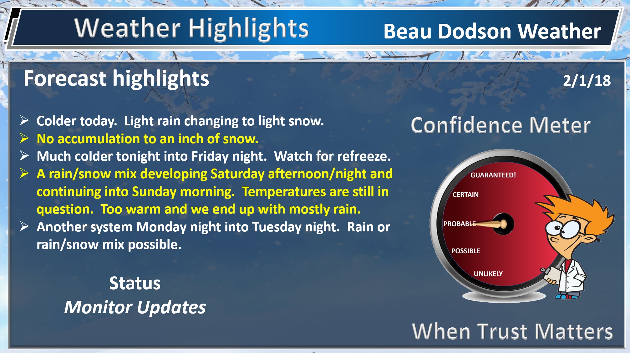
Thursday into Thursday night: Flurries or snow showers are possible Thursday late morning into the evening. No snow accumulation to less than an inch of snow. Monitor roadways Thursday night. If moisture remains on the roads, then it could freeze. Winds may help dry the roads.
Rain and snow possible Saturday afternoon/evening into early Sunday morning. At this time, temperatures appears to be marginal for snow accumulation. If the system tracks further south then snow chances increase. At this time, it appears to be a rain and rain/snow mix event. That would mean very little in the way of accumulation. Confidence is low to medium on this forecast. Monitor updates. The forecast will evolve over the next 24 to 36 hours.
A chance of snow flurries or snow showers Sunday night.
I am monitoring another system late Monday night into Tuesday night. That would likely be rain or rain/snow mix. Temperatures are questionable.
.

.
The National Weather Service definition of a severe thunderstorm is one that produces quarter size hail or larger, 58 mph winds or greater, and/or a tornado.
Now through next Friday No severe weather concerns.
.

.
.
.
.
Forecast:
Winter Weather Radar
Be sure and turn on the winterize button above the local city view radars
Interactive Weather Radar Page. Choose the city nearest your location: Click this link.
Sorry for the late update. I wanted to review the morning data.
Wednesday night into Friday night:
HIGHLIGHTS
- Colder today into the weekend
- Light rain today may end as snow showers. No accumulation to less than an inch of snow.
- Watch for moisture refreezing tonight (any standing water on sidewalks, parking lots, and roads).
- Wind chill values tonight into Friday morning will drop into the single digits to lower teens.
High confidence in the forecast through Saturday afternoon.
A cold front has been moving through the area.
Clouds and light rain will hold temperatures down today. You can expect highs in the 36 to 46 degree range. Temperatures will hold steady or fall this afternoon as colder air pushes into the region from the north.
A band of light rain has formed behind the front. This light rain will move south and southeast over the next 12 hours. See the interactive city view radars.
Rain may mix with or change to snow showers this afternoon into the early evening hours. If moisture remains on roadways, then it could refreeze.
A few locations may have a burst of snow later today/this afternoon that could produce a dusting to an inch. Ground conditions are warm. The light nature of the precipitation also is a negative factor for accumulation. With that said, if there were heavier bursts of snow showers, then a quick dusting or so could occur in some locations.
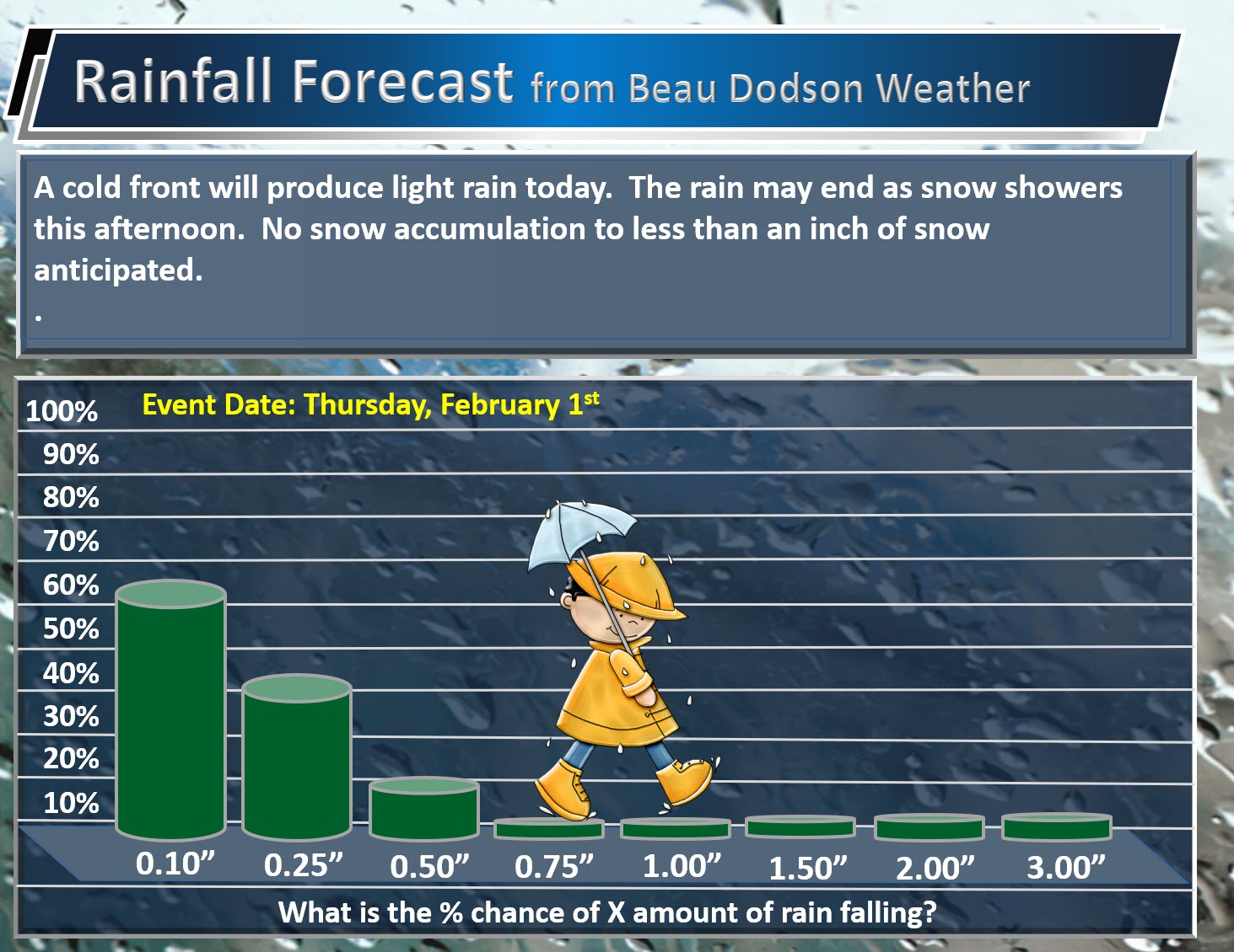
Some areas may receive no measurable rain or snow today.
Here is my rainfall totals forecast.
What is the % chance of X amount of rain falling?
.
.
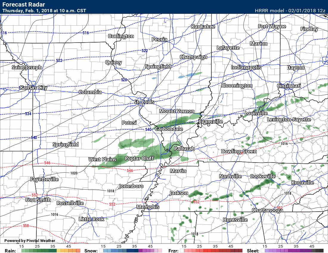
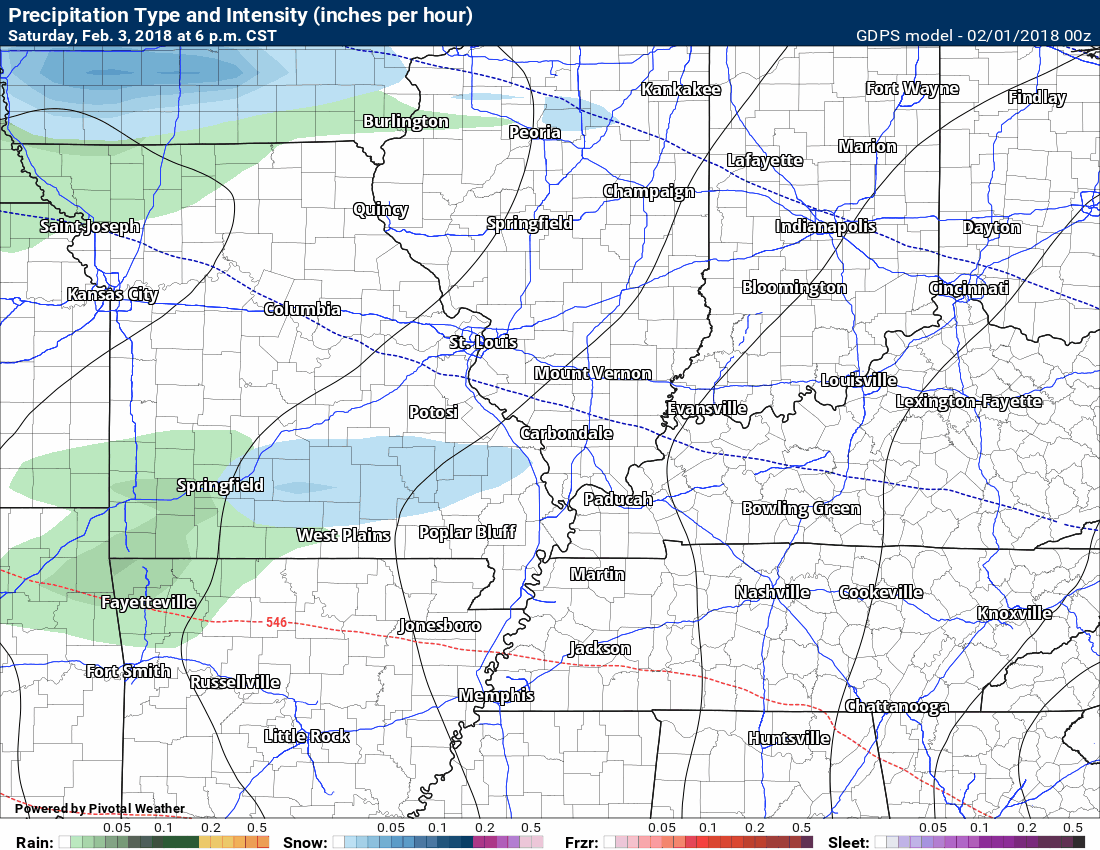
Here is the latest Hrrr model guidance future-cast radar. Green represents rain. Blue represents snow. Rain may change to snow later today.
.
.
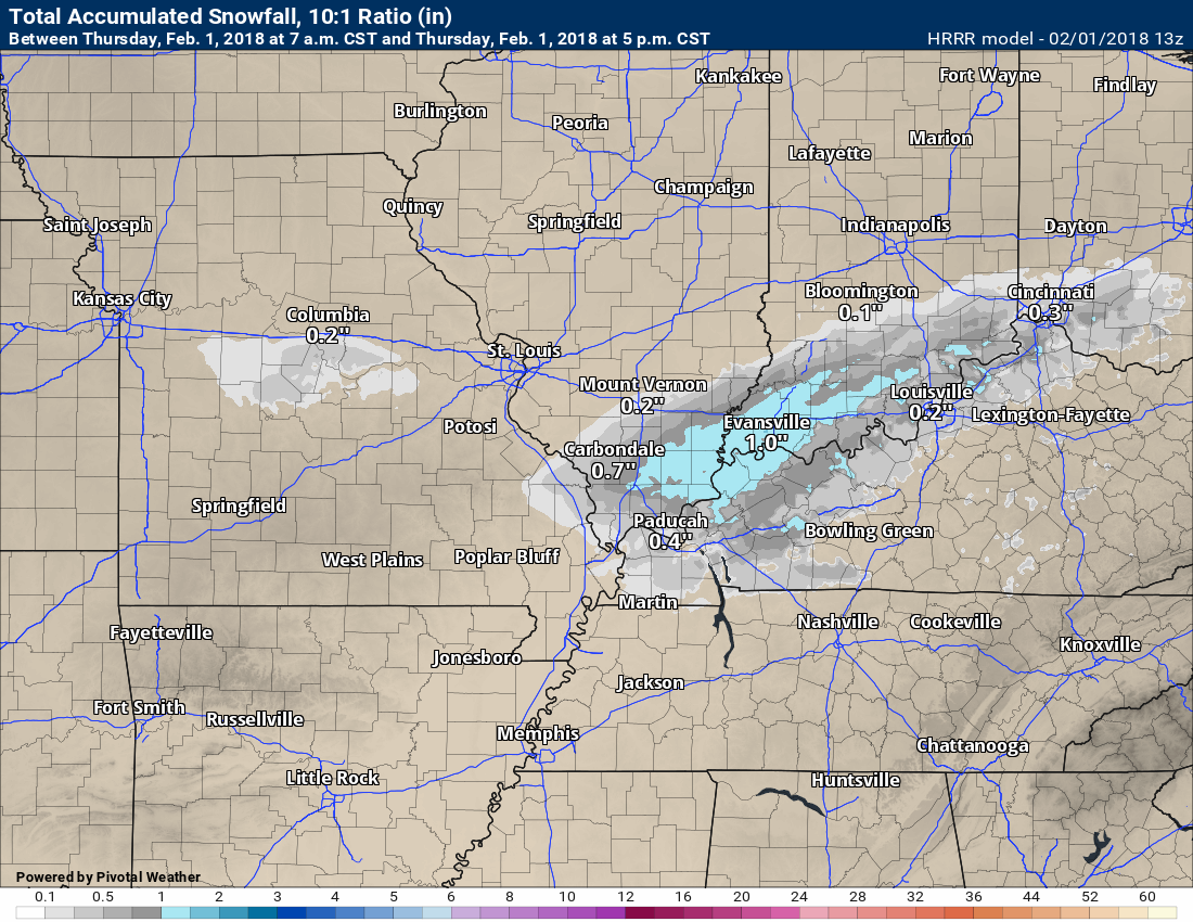
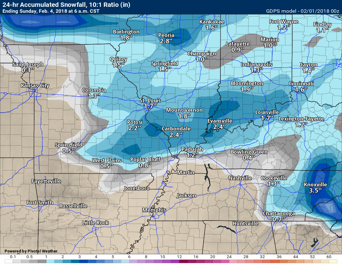
The Hrrr model does show light snow accumulation in our local area. I can’t rule it out, but warm ground conditions won’t make it easy for snow to accumulate.
No snow accumulation to less than an inch of snow is the going forecast.
Snow accumulation map (below) from the Hrrr model.
.
.
I will be monitoring wet roadways Thursday night. If moisture remains on roads, then patchy slick spots are possible. Gusty winds may help dry the roads fairly quickly.
Here is my latest snow probability forecast map for today.
.
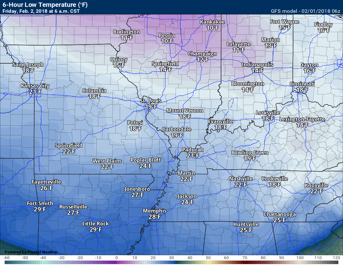
Temperatures, by Friday morning, will have dropped into the upper teens to lower 20’s. Brrr.
6 AM Friday temperature map.
.
.
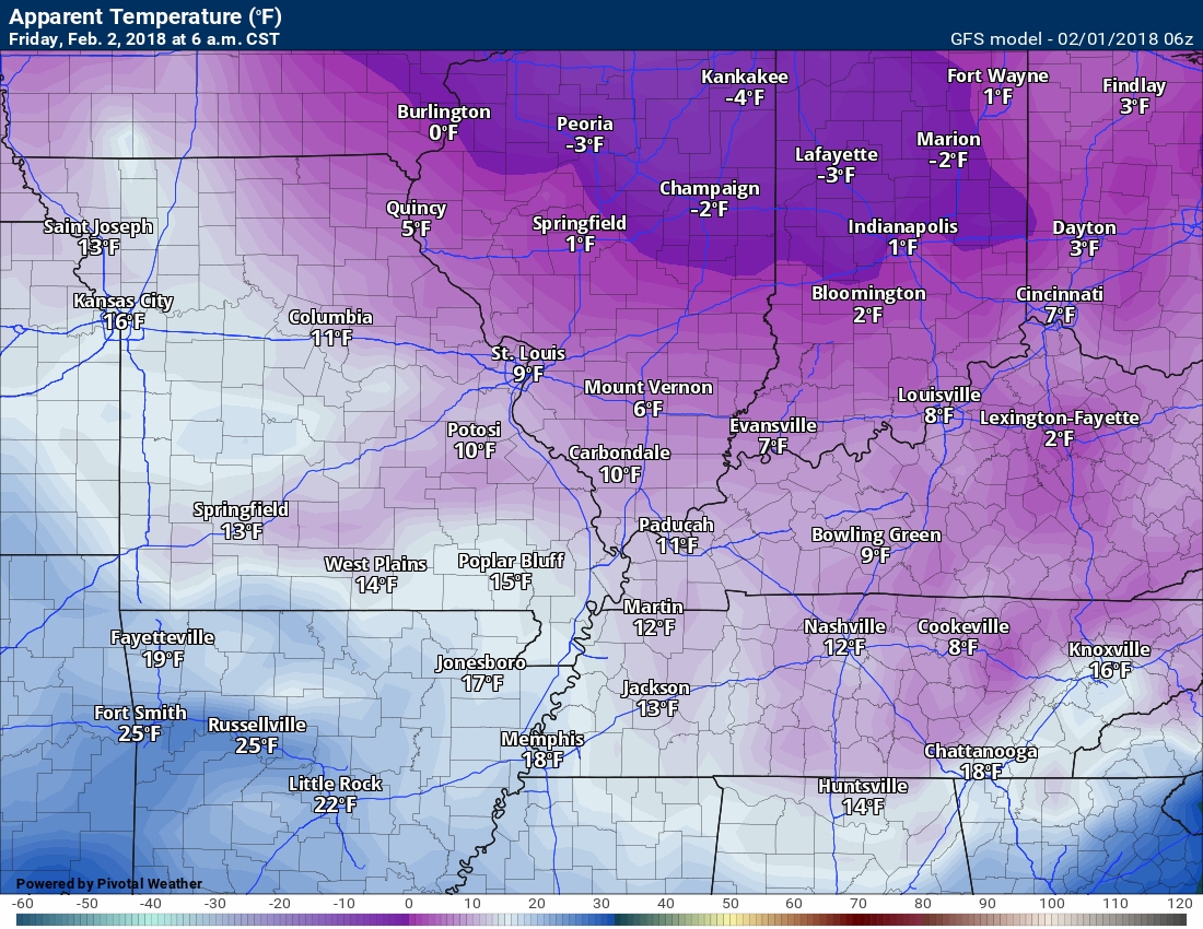
Wind chills will be even colder. Wind chill is what the temperature feels like to your skin.
Here is the 6 AM Friday wind chill map.
.
.
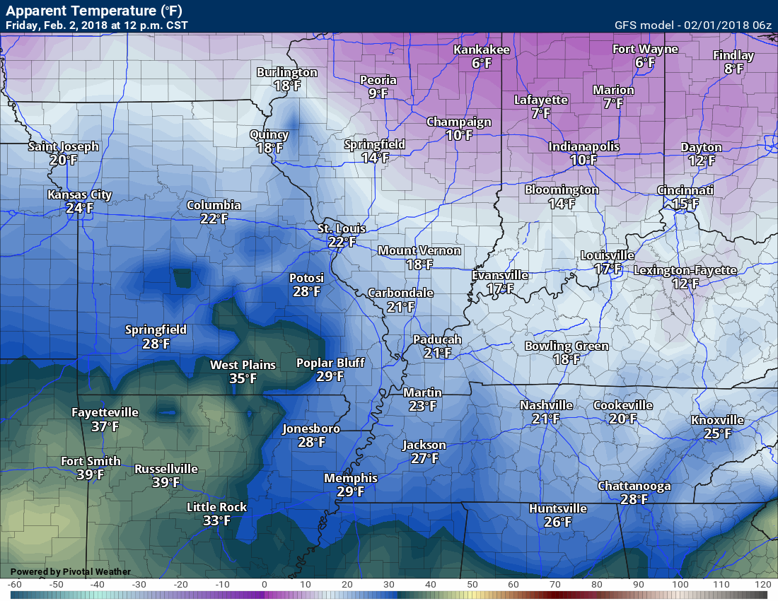
Here is the 12 PM Friday wind chill map
.
.
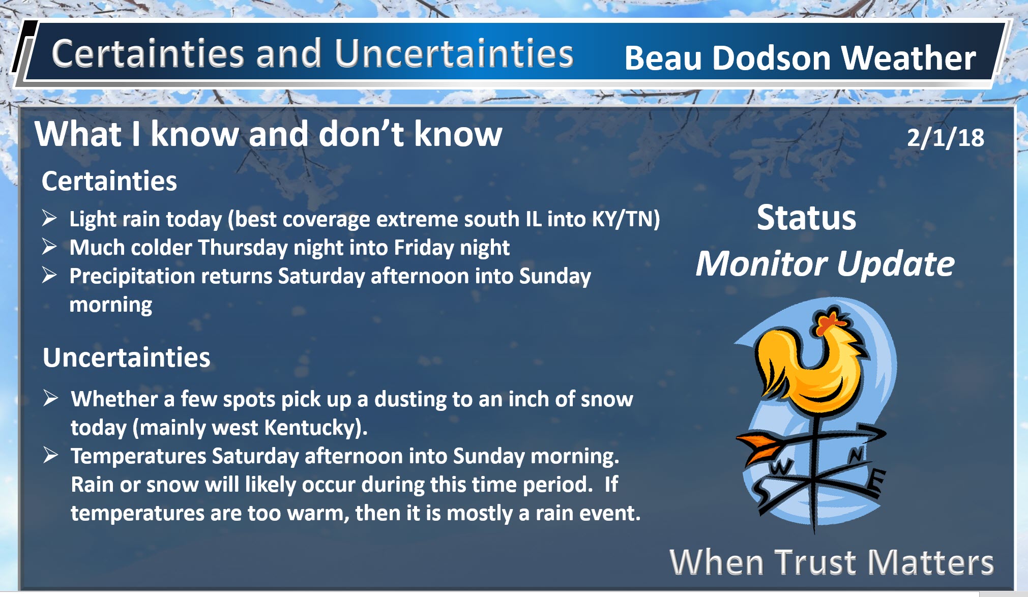
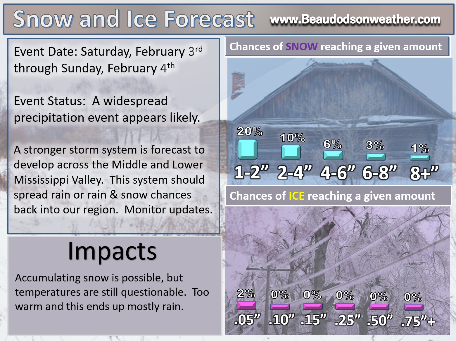
Saturday into Sunday night:
HIGHLIGHTS
- Increasing chances of rain and snow Saturday afternoon into Sunday
- There is a chance of accumulating snow, but confidence on the finer details remains low. It may be mostly a rain event.
- Monitor travel forecasts for the weekend. Icy roads are possible in or near our region, but confidence remains low.
High confidence there will be precipitation
Low confidence on accumulating snow and ice
We have been tracking these systems for over two weeks. As always, the devil is in the details. It is easier for me to forecast an upcoming weather pattern than how an individual system will unfold within that pattern.
Winter storms are particularly difficult to forecast. The reason for this is because the exact track of the upper level features is what is important. A shift of 25 to 50 miles can completely change a snow forecast to rain.
Our region is known for tricky weather forecasting.
The weekend system will be no difficult. The details will need to be ironed out. Guidance has been trending warmer and warmer. That would mean more rain vs wintry precipitation.
There remain a lot of questions with this event. Confidence on whether accumulating wintry precipitation will occur probably won’t increase until late Thursday night or Friday morning. I don’t like to forecast snow totals more than 24 to 36 hours out. Even then, most forecasts still need adjusting as the storm unfolds. This is the nature of the beast.
Again, guidance has been trending warmer. If guidance continues to trend warmer, then this will mostly be a rain event.
Did you know, a total of 0.10″ of rain equals approximately 1″ of snow. In other words if you melted one inch of snow, then it would equal approximately 0.10″ of water. If it rained 0.10″ on a Tuesday night in August, then you probably would wake up and never know it rained. Do the same in the winter and you have a morning travel headache with school closings.
Slight increases in moisture numbers can mean the difference between a dusting of snow and two or three inches of snow.
With all of that said, let’s break it down.
The track and intensity of the system is key to our sensible weather. In other words, it is key in determining whether we have rain, snow, or both.
If the system is mature/stronger, then colder air will filter into our region and we will have rain changing to sleet and snow.
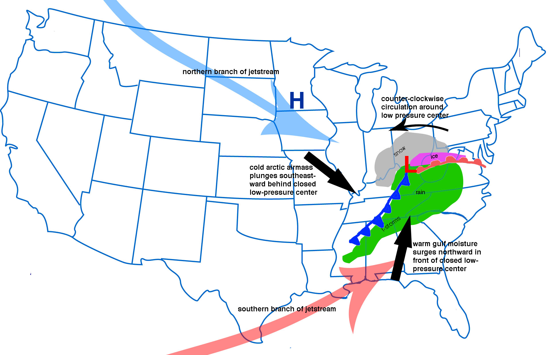
Remember, low pressure rotates counter-clockwise. If the low pressure center tracks to our south and southeast, then we end up on the cold side of the system. That is where your better snow chances are situated.
Here, let me show you an example (this is just a random weather map and is not current).
.
.
Let’s look at what the GFS and NAM guidance is showing for Saturday and Sunday.
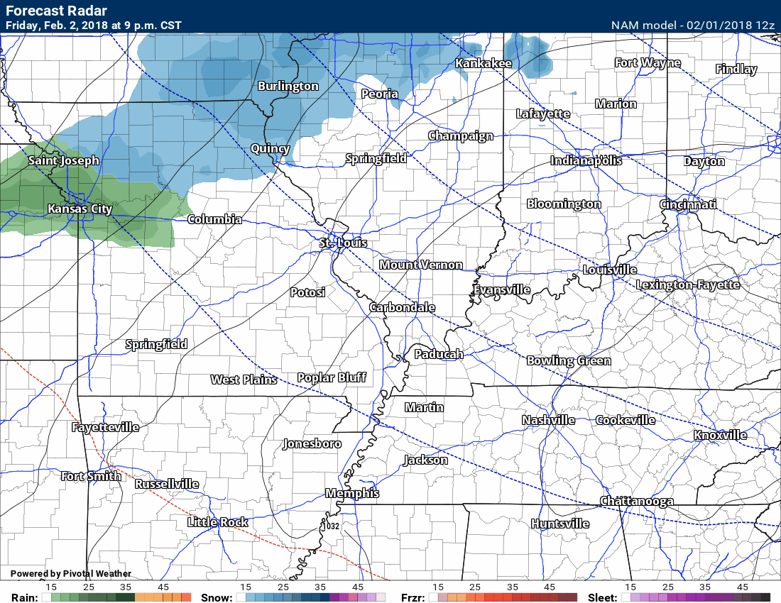
This is the NAM model guidance future-cast radar (precipitation). This is one of many models. This is the main run of the NAM.
This graphic is showing mostly a rain event. There are periods of rain/snow mix, but mostly rain. Temperatures on the NAM are warm enough for mostly rain.
The NAM shows some precipitation as early as late Friday night/Saturday morning. This seems to be suspect. Most of the guidance is dry. I will keep an eye on that part of the forecast. Temperatures Friday night will be cold.
Green is rain. Blue is snow. Other colors are a wintry mix.
Time stamp upper left.
.
.
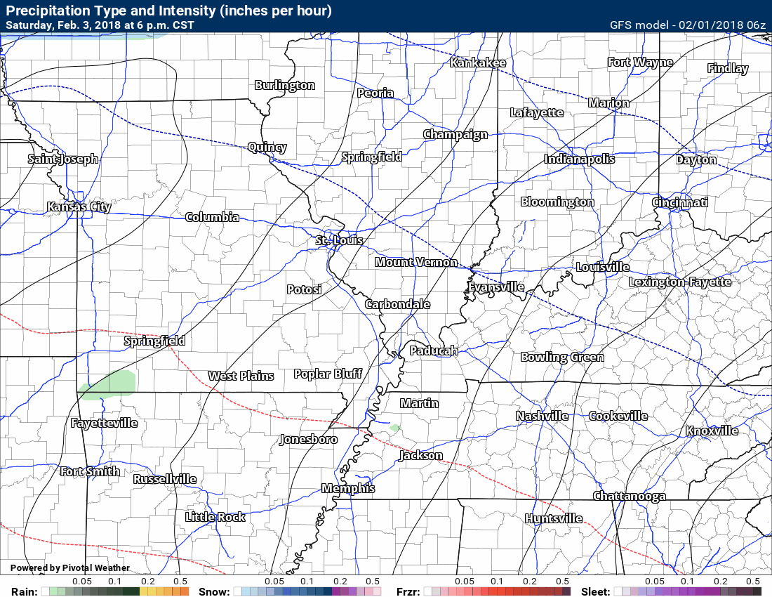
Here is the GFS future-cast radar. It does not show any precipitation Friday night or Saturday morning.
It does show the Saturday evening into Sunday morning precipitation.
.
.
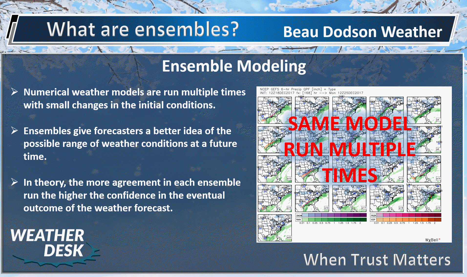
Let’s look at the GFS ensembles. Want to learn more about ensembles? Click here to read more about them.
.
.
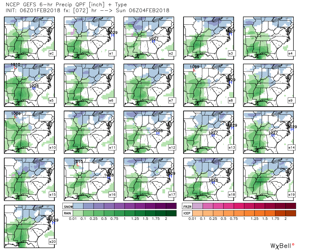
What is this graphic showing you?
This is showing you the GEFS (GFS model) ensemble precipitation forecast through 12 AM Sunday. Again, read about ensembles in the graphic above or the link I provided to you.
Most of the GEFS forecast panels are showing widespread precipitation. Many of them are showing rain Saturday. Rain perhaps changing to snow. Each panel is one run of the GEFS model.
This first graphic is the six hour precipitation totals from 6 PM Saturday through 12 AM Sunday.
Confidence is high that we will have precipitation on radar Saturday night into Sunday. Odds are favoring rain or rain/snow mix.
Green is rain. Blue is snow.
Click image to enlarge.
.
.
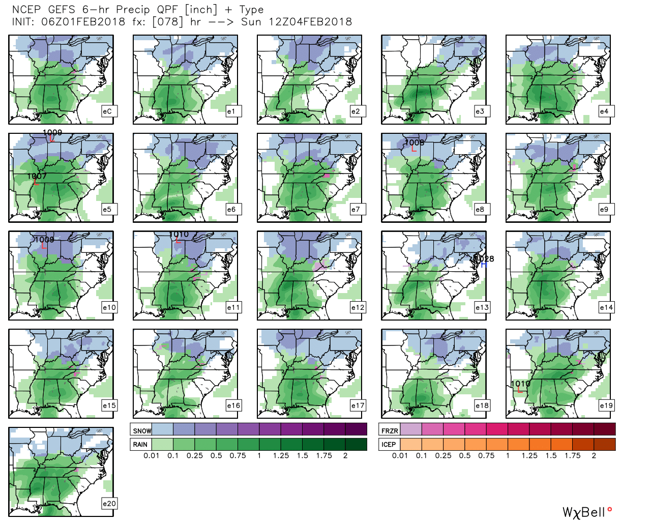
This next graphic is 12 AM Sunday through 6 AM Sunday
These are the six hour precipitation totals. The scale can be found at the bottom of the graphic.
Most of the panels are showing widespread rain or snow in our local area.
.
.
Let’s move to another model.
This is the Canadian GEM model future-cast radar from Saturday 6 PM through Sunday 6 PM. The GEM shows rain and rain/snow mix. It is a bit cooler than other models. This will need to be monitored, of course.
Green is rain and blue is snow.
.
.
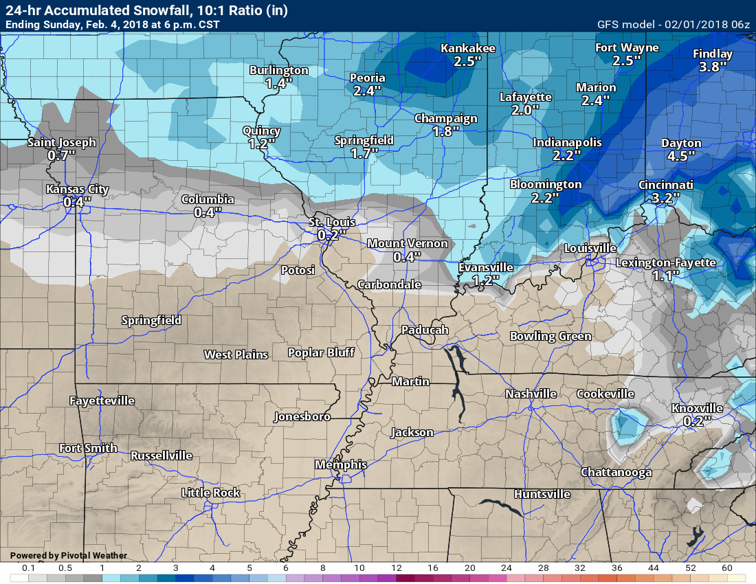
Let me show you what some of the models are forecasting for snow totals.
I will show you the graphics, but keep in mind, this isn’t my forecast. I am simply showing you what the model is spitting out.
The Canadian model shows the higher accumulating snow totals over Missouri and Illinois. It is the coldest model.
Click to enlarge.
.
.
The GFS model shows little or no snow accumulation.
.
.
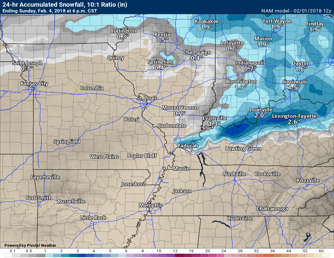
The NAM guidance
Attempts to paint some patchy snow accumulation. NAM is mostly rain.
.
.
My Forecast
Currently my forecast calls for rain or rain/snow mix (few sleet pellets possible) developing Saturday afternoon and then a rain/snow mix Saturday night into Sunday morning. Monitor updates. The forecast will evolve with time.
This is my graphic showing you snow accumulation probabilities. This could, of course, change as confidence in the final forecast increases.
There is the potential of wintry precipitation, but confidence in accumulating snow is low.
If you have travel plans Saturday through Wednesday, then you should monitor updates.
.
.
The pattern is going to remain active. Numerous disturbances will track through the region over the coming 14 day period.
There are strong indications of several shots of bitterly cold air during the Month of February. A prolonged period of cold weather is possible. If this happens, then electric bills will once again be higher than normal. Plan accordingly.
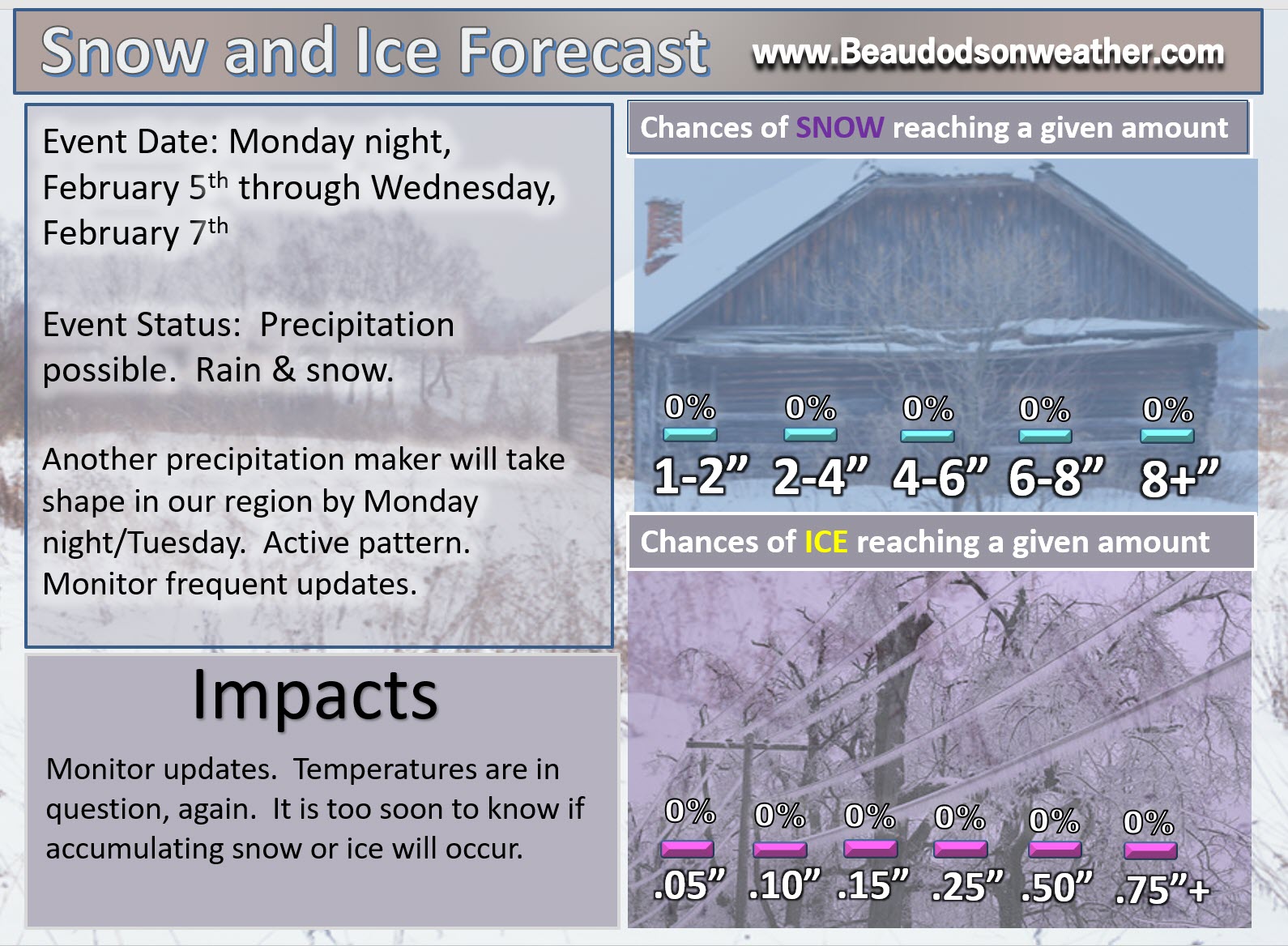
Another disturbance will bring additional rain or snow chances Monday night into Tuesday night.
This graphic covers the Monday night into Tuesday night event. Models are all over the place, once again. Confidence is low.
.
.
Everything below is for Weather Talk subscribers. Subscribe at www.beaudodsonweather.com
https://weathertalk.com/app/dailysummary
LONG RANGE OUTLOOKS
Preliminary Spring Outlook
Week one temperature outlook
Week one precipitation departure outlook
Week two temperature outlook
Week two precipitation outlook
Week three and four temperature and precipitation outlook
February Outlook
March preliminary temperature and precipitation outlook.
Long Range Video update.
Illinois centered video (includes portions of Kentucky)
Missouri Valley centered video
.


We offer regional radars and local city radars – if a radar does not update then try another one. Occasional browsers need their cache cleared. You may also try restarting your browser. This will usually fix any problems.
During the winter you can track snow and ice by clicking the winterize button on the local city view interactive radars.
You may email me at beaudodson@usawx.com
Interactive Weather Radar Page. Choose the city nearest your location: Click this link
National interactive radar: Click this link.