We have some great sponsors for the Weather Talk Blog. Please let our sponsors know that you appreciate their support for the Weather Talk Blog.
Milner and Orr Funeral Home and Cremation Services located in Paducah, Kentucky and three other western Kentucky towns – at Milner and Orr they believe in families helping families. You can find Milner and Orr on Facebook, as well.
![]()
.

Wortham Dental Care located in Paducah, Kentucky. The gentle dentist. Mercury free dentistry. They also do safe Mercury removal. You can find Wortham Dental Care on Facebook, as well
.

For all of your families eye care needs. Visit their web-site here. Or, you can also visit their Facebook page.
.

Endrizzi’s Storm Shelters – For more information click here. Endrizzi Contracting and Landscaping can be found on Facebook, as well – click here
.

Best at Enabling Body Shop Profitability since 1996. Located In Paducah Kentucky and Evansville Indiana; serving all customers in between. They provide Customer Service, along with all the tools necessary for body shops to remain educated and competitive. Click the logo above for their main web-site. You can find McClintock Preferred Finishes on Facebook, as well
.

Duck/goose decoys? Game calls? Optics? We have you covered! Click the logo above or visit Final Flight on Facebook, as well.
.
.
I have launched the new weather texting service! I could use your help. Be sure and sign up and fully support all of the weather data you see each day.
This would make a great Christmas present for someone 🙂
This is a monthly subscription service. Supporting this helps support everything else. The cost is $3 a month for one phone, $5 a month for three phones, and $10 a month for seven phones.
For more information visit BeauDodsonWeather.com
Or directly sign up at Weathertalk.com


This forecast update covers far southern Illinois, far southeast Missouri, and far western Kentucky. See the coverage map on the right side of the blog.
Remember that weather evolves. Check back frequently for updates, especially during active weather.
Monday night – Rain ending. Gusty winds. Colder. Winds will die down after midnight.
Temperatures: Lows in the upper 30s to around 40.
Winds: Southwest winds at 8-16 mph and gusty at times. Winds will die down after midnight into the 4-8 mph range.
What is the chance for precipitation? 20% early
Coverage of precipitation? Scattered early
My confidence in this part of the forecast verifying is High
Should I be concerned about snow or ice? No
Should I cancel my outdoor plans? No, but a few showers may remain in the area.
Is severe weather expected? No
What impact is expected? Wet roadways. Potential for large rises on some rivers and streams.
River Crest Forecasts are posted further down in the blog.
Click Here For River Stage Forecasts…
Tuesday – Quiet a few clouds. Colder than recent days. Finally, it might feel like winter?
Temperatures: Highs in the 38 to 45 degree range
Winds: West/southwest winds at 6-12 mph. Gusts to 15 mph during the morning hours.
What is the chance for precipitation? 0%
Coverage of precipitation? None
My confidence in this part of the forecast verifying is High
Should I be concerned about snow or ice? No
Should I cancel my outdoor plans? No
Is severe weather expected? No
What impact is expected? Rivers and streams may have flooding problems. Large rises on rivers are possible over the coming week.
Tuesday night – Quiet a few clouds. Chilly. But, nothing unusual for late December. Just a small chance for a sprinkle.
Temperatures: Lows 32 to 36 degrees
Winds: Southwest winds at 0-5 mph. Light.
What is the chance for precipitation? 10%
Coverage of precipitation? None
My confidence in this part of the forecast verifying is High
Should I be concerned about snow or ice? No
Should I cancel my outdoor plans? No
Is severe weather expected? No
What impact is expected? Rivers and streams may have flooding problems. Large rises on rivers are possible over the coming week.
Wednesday – Mostly cloudy. Cool.
Temperatures: Highs in the middle 40s
Winds: West winds 3-6 mph. Winds in the afternoon may gust into the 10-12 mph range.
What is the chance for precipitation? 0%
Coverage of precipitation? None
My confidence in this part of the forecast verifying is High
Should I be concerned about snow or ice? No
Should I cancel my outdoor plans? No
Is severe weather expected? No
What impact is expected? Rivers and streams may have flooding problems. Large rises on rivers are possible over the coming week.
Wednesday night – Just a few clouds and colder.
Temperatures: Lows in the upper 20s
Winds: North and northwest winds at 5 mph
What is the chance for precipitation? 0%
Coverage of precipitation? None
My confidence in this part of the forecast verifying is High
Should I be concerned about snow or ice? No
Should I cancel my outdoor plans? No
Is severe weather expected? No
What impact is expected? Rivers and streams may have flooding problems. Large rises on rivers are possible over the coming week.
Thursday – Quite a bit of sun anticipated. But, it will be cold.
Temperatures: Highs in the 30s
Winds: Northwest at 6-12 mph
What is the chance for precipitation? 0%
Coverage of precipitation? None
My confidence in this part of the forecast verifying is High
Should I be concerned about snow or ice? No
Should I cancel my outdoor plans? No
Is severe weather expected? No
What impact is expected? Rivers and streams may have flooding problems. Large rises on rivers are possible over the coming week.
Click their ad below to visit their web-site or click here reedelec.com


Don’t forget to check out the Southern Illinois Weather Observatory web-site for weather maps, tower cams, scanner feeds, radars, and much more! Click here

An explanation of what is happening in the atmosphere over the coming days…
Highlights
1. River flooding is the concern
2. Major river flooding will occur over the next ten days. Especially the Mississippi River
3. Much colder weather Tuesday into the first ten days of January.
4. Avoid flooded roadways.
5. Colder temperatures will last into the first week of January
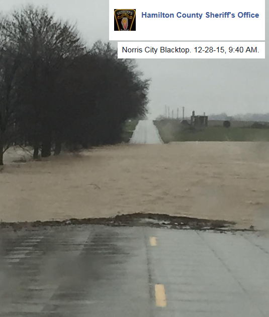
Wow. Have we been through the wringer. But, it could always be worse. The tornadoes in Texas and Mississippi have damaged or destroyed over 1500 homes. The flooding is now destroying even more.
This has been a destructive week in weather history. It will certainly go down in to the books as one of the more serious severe weather and flood events for the Month of December. The year 1982 was very similar to this. We had tornadoes on Christmas Eve that year. It also was an El Nino year. This is a large El Nino and it is having an impact. It is not the only reason for this pattern, but it is a significant factor.
I have spent most of today covering the weather via Facebook and the texting service. I encourage you to sign up for the texting. This supports all of the information I bring to you on a daily basis.
Weather…
The good news is that dry weather is forecast into the weekend. Outside of some clouds on Tuesday into Wednesday (maybe a light shower), I don’t have anything major I am tracking in the short term forecast.
The data does indicate a potential event about 8-10 days from now. Let’s keep an eye on it. Another southern jet stream system. Those typically produce a lot of precipitation.
Please avoid flooded roadways. Also, deer will be out and about more than normal. They are being flooded out of their nesting areas.
Here are just a few images from the storm system
Just look at this map. A 994 low over southeast Missouri. TIGHTLY wound system. Those lines are isobars. Equal lines of pressure. We are fortunate that we did not have a larger severe weather outbreak in our region from this storm system. We are fortunate.

Here is what the precipitation map looked like on Monday at 11 am. Blue/purple snow. Orange and pink would be ice. Green is rain.


Here are the current river stage forecasts. You can click your state and then the dot for your location. It will bring up the full forecast and hydrograph.
Click Here For River Stage Forecasts…
Here are some current forecast hydrographs. These will be updated each day with new information.


Smithland Lock and Dam

Paducah, Kentucky Forecast Stage

Cairo, Illinois

Cape Girardeau, Missouri
Clickable map


Here are the current river stage forecasts. You can click your state and then the dot for your location. It will bring up the full forecast and hydrograph.
Click Here For River Stage Forecasts…

No snow anticipated.

Monday – No snow or ice anticipated.
Tuesday – No snow or ice anticipated.
Wednesday – No snow or ice anticipated.
Thursday- No snow or ice anticipated.
Friday – No snow or ice anticipated.

No major changes in this update.

The main concern for the coming week will be sharp rises on area rivers. Some historic crest numbers are being forecast for the Mississippi River. Large rises are expected on the Ohio River.
Monitor the latest crest forecast numbers.
Avoid flooded roadways.

Monitor river stages.

The wild card in the forecast will be crest levels on the Mississippi River and Ohio River. It appears there will be sharp rises on both rivers. Will Cape Girardeau, Missouri reach their highest crest in recorded history? It does appear possible.

How much precipitation should we expect over the next few days?
No significant rainfall anticipated through Friday. There could be some light rain or sprinkles, but nothing of significance.

Can we expect severe thunderstorms over the next 24 to 48 hours? Remember that a severe thunderstorm is defined as a thunderstorm that produces 58 mph winds or higher, quarter size hail or larger, and/or a tornado.
The thunderstorm threat level will be a ZERO for Tuesday through Friday.
.
Tuesday – Severe weather is not anticipated.
Wednesday through next Friday – Severe weather is not anticipated.

We have regional radars and local city radars – if a radar does not seem to be updating then try another one. Occasional browsers need their cache cleared. You may also try restarting your browser. That usually fixes the problem. Occasionally we do have a radar go down. That is why I have duplicates. Thus, if one fails then try another one.
If you have any problems then please send me an email beaudodson@usawx.com
WEATHER RADAR PAGE – Click here —
We also have a new national interactive radar – you can view that radar by clicking here.
Local interactive city radars include St Louis, Mt Vernon, Evansville, Poplar Bluff, Cape Girardeau, Marion, Paducah, Hopkinsville, Memphis, Nashville, Dyersburg, and all of eastern Kentucky – these are interactive radars. Local city radars – click here
NOTE: Occasionally you will see ground clutter on the radar (these are false echoes). Normally they show up close to the radar sites – including Paducah.


Here is the official 6-10 day and 8-14 day temperature and precipitation outlook. Check the date stamp at the top of each image (so you understand the time frame).
The forecast maps below are issued by the Weather Prediction Center (NOAA).


The latest 8-14 day temperature and precipitation outlook. Note the dates are at the top of the image. These maps DO NOT tell you how high or low temperatures or precipitation will be. They simply give you the probability as to whether temperatures or precipitation will be above or below normal.


Here are the current river stage forecasts. You can click your state and then the dot for your location. It will bring up the full forecast and hydrograph.
Click Here For River Stage Forecasts…

Who do you trust for your weather information and who holds them accountable?
I have studied weather in our region since the late 1970’s. I have 37 years of experience in observing our regions weather patterns. My degree is in Broadcast Meteorology from Mississippi State University and an Associate of Science (AS). I am currently working on my Bachelor’s Degree in Geoscience.
My resume includes:
Member of the American Meteorological Society.
NOAA Weather-Ready Nation Ambassador.
Meteorologist for McCracken County Emergency Management. I served from 2005 through 2015.
I own and operate the Southern Illinois Weather Observatory.
Recipient of the Mark Trail Award, WPSD Six Who Make A Difference Award, Kentucky Colonel, and the Caesar J. Fiamma” Award from the American Red Cross.
In 2009 I was presented with the Kentucky Office of Highway Safety Award.
Recognized by the Kentucky House of Representatives for my service to the State of Kentucky leading up to several winter storms and severe weather outbreaks.
I am also President of the Shadow Angel Foundation which serves portions of western Kentucky and southern Illinois.
There is a lot of noise on the internet. A lot of weather maps are posted without explanation. Over time you should learn who to trust for your weather information.
My forecast philosophy is simple and straight forward.
- Communicate in simple terms
- To be as accurate as possible within a reasonable time frame before an event
- Interact with you on Twitter, Facebook, and the blog
- Minimize the “hype” that you might see on television or through other weather sources
- Push you towards utilizing wall-to-wall LOCAL TV coverage during severe weather events
I am a recipient of the Mark Trail Award, WPSD Six Who Make A Difference Award, Kentucky Colonel, and the Caesar J. Fiamma” Award from the American Red Cross. In 2009 I was presented with the Kentucky Office of Highway Safety Award. I was recognized by the Kentucky House of Representatives for my service to the State of Kentucky leading up to several winter storms and severe weather outbreaks.
If you click on the image below you can read the Kentucky House of Representatives Resolution.

Many of my graphics are from www.weatherbell.com – a great resource for weather data, model data, and more


You can sign up for my AWARE email by clicking here I typically send out AWARE emails before severe weather, winter storms, or other active weather situations. I do not email watches or warnings. The emails are a basic “heads up” concerning incoming weather conditions.