
WeatherTalk monthly operating costs can top $2000.00. Your $5 subscription helps pay for those costs. I work for you.
The $5 will allow you to register up to seven phones!
For $5 a month you can receive the following. You may choose to receive these via your WeatherTalk app or regular text messaging.
Severe weather app/text alerts from my keyboard to your app/cell phone. These are hand typed messages from me to you. During tornado outbreaks, you will receive numerous app/text messages telling you exactly where the tornado is located.
- Daily forecast app/texts from my computer to your app/cell phone.
- Social media links sent directly to your app/cell phone. When I update the blog, videos, or Facebook you will receive the link.
- AWARE emails. These emails keep you well ahead of the storm. They give you several days of lead time before significant weather events.
- Direct access to Beau via text and email. Your very own personal meteorologist. I work for you!
- Missouri and Ohio Valley centered video updates
- Long-range weather videos
- Week one, two, three and four temperature and precipitation outlooks.
Monthly outlooks. - Your subscription also will help support several local charities.
Would you like to subscribe? Subscribe at www.beaudodsonweather.com
Typical progression on a severe weather day for subscribers.


I encourage subscribers to use the app vs regular text messaging. We have found text messaging to be delayed during severe weather. The app typically will receive the messages instantly. I recommend people have three to four methods of receiving their severe weather information.
Remember, my app and text alerts are hand typed and not computer generated. You are being given my personal attention during significant weather events.

WWW.WEATHERTALK.COM subscribers, here is my day to day schedule for your weather products.
These are bonus videos and maps for subscribers. I bring these to you from the BAMwx team. I pay them to help with videos.
The Ohio and Missouri Valley videos cover most of our area. They do not have a specific Tennessee Valley forecast but may add one in the future.
The long-range video is technical. Over time, you can learn a lot about meteorology from the long range video. Just keep in mind, it is a bit more technical.


Subscribe at www.weathertalk.com
![]()

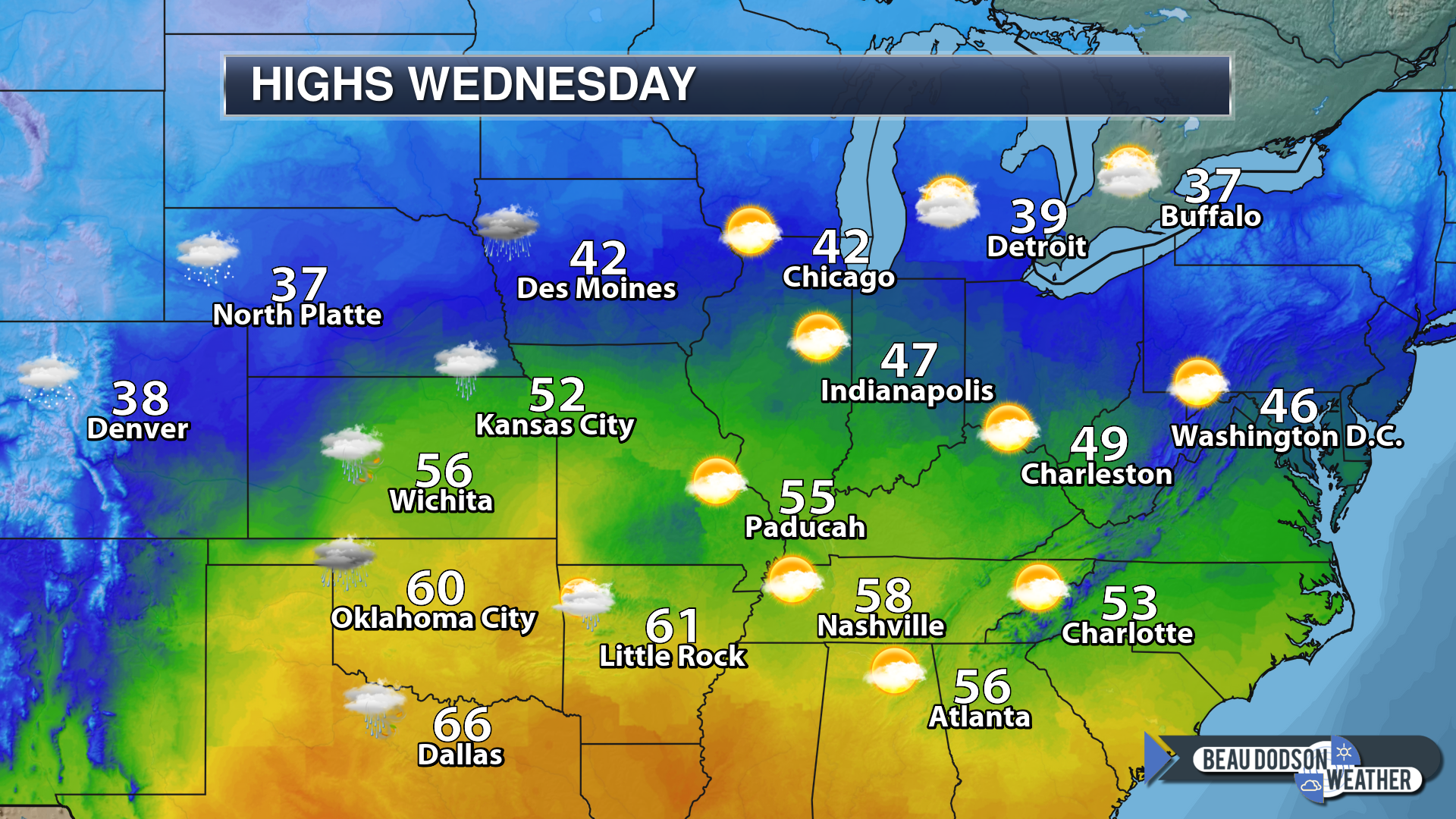
December 26, 2018
Wednesday Forecast: Mostly cloudy. Mild for the end of December. Becoming breezy. A few southeast Missouri showers are possible. Lower chances elsewhere.
My confidence in the forecast verifying: Medium (50% confidence in the forecast)
Temperature range: MO ~ 53 to 56 IL ~ 52 to 54 KY ~ 53 to 56 TN ~ 55 to 60
Wind chill (feels like) temperature forecast:
What is the chance/probability of precipitation? MO ~ 30% IL ~ 20% KY ~ 20% TN ~ 20%
Coverage of precipitation: Isolated (mainly PM hours over southeast Missouri)
Is flash flooding anticipated? No
Is accumulating snow or ice anticipated? No
Is non-accumulating snow or ice anticipated? No
Are icy road conditions anticipated? No
Wind direction and speed: East and southeast at 7 to 14 mph with gusts to 20 mph
What impacts are anticipated from the weather? A few wet roadways across southeast Missouri. Smaller chances elsewhere.
Is severe weather expected? No
The NWS officially defines severe weather as 58 mph wind or great, 1″ hail or larger, and/or tornadoes
Will lightning be possible? No
Should I cancel my outdoor plans? No
Will the weather impact my outdoor plans? For most areas, no. A few showers could produce damp conditions. Rain chances increase Wednesday night.
UV Index: 2 Low
Sunrise: 7:08 AM
Wednesday Night Forecast Details:
Forecast: Cloudy. Rain showers developing. Temperatures steady or rising. Breezy.
My confidence in the forecast verifying: High (70% confidence in the forecast)
Temperature range: MO ~ 50 IL ~ 50 KY ~ 50 TN ~ 50
Wind chill (feels like) temperature forecast:
What is the chance/probability of precipitation? MO ~ 70% IL ~ 50% KY ~ 50% TN ~ 50%
Coverage of precipitation: Increasing coverage overnight.
Is flash flooding anticipated? No
Is accumulating snow or ice anticipated? No
Is non-accumulating snow or ice anticipated? No
Are icy road conditions anticipated? No
Wind direction and speed: East and southeast at 6 to 12 mph with gusts to 25 mph
What impacts are anticipated from the weather? Wet roadways.
Is severe weather expected? No
The NWS officially defines severe weather as 58 mph wind or great, 1″ hail or larger, and/or tornadoes
Will lightning be possible? Most likely no, but monitor updates.
Should I cancel my outdoor plans? Don’t cancel outdoor plans but monitor radars.
Will the weather impact my outdoor plans? Rain could cause damp conditions. This may interfere with some activities.
Sunset: 4:43 PM
Moonrise: 9:30 PM Waning Gibbous
Moonset: 10:28 AM
December 27, 2018
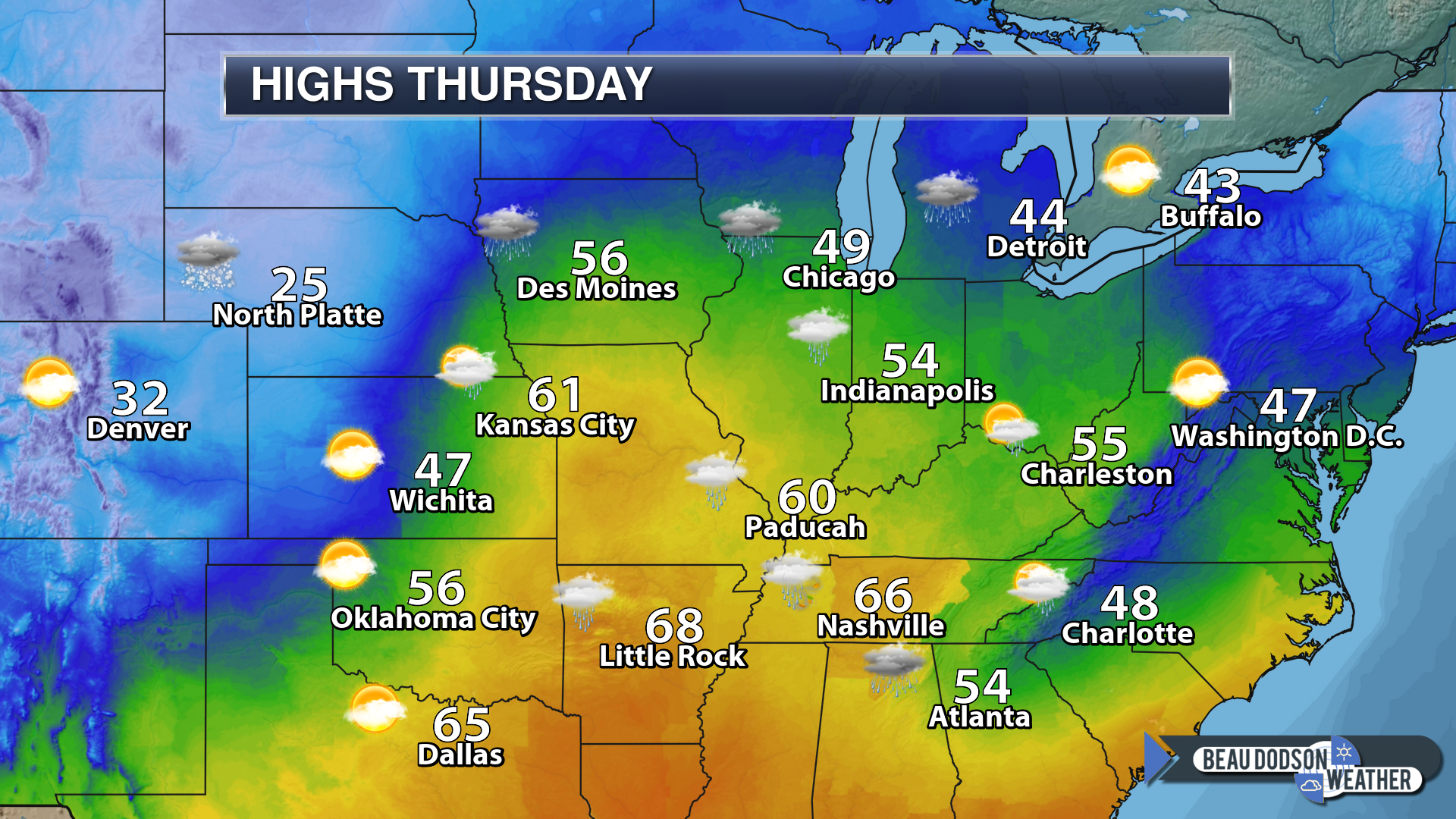
Thursday Forecast: Windy. Cloudy. Rain. A thunderstorm possible. Mild. Moderate rain possible.
My confidence in the forecast verifying: High (90% confidence in the forecast)
Temperature range: MO ~ 56 to 62 IL ~ 56 to 62 KY ~ 56 to 62 TN ~ 56 to 62
Wind chill (feels like) temperature forecast:
What is the chance/probability of precipitation? MO ~ 100% IL ~ 100% KY ~ 90% TN ~ 100%
Coverage of precipitation: Widespread
Is flash flooding anticipated? Low risk
Is accumulating snow or ice anticipated? No
Is non-accumulating snow or ice anticipated? No
Are icy road conditions anticipated? No
Wind direction and speed: South and southeast at 20 to 40 mph. Gusty.
What impacts are anticipated from the weather? Wet roadways. Lightning possible. Strong winds.
Is severe weather expected? There is a small risk of a severe thunderstorm. Monitor updates.
The NWS officially defines severe weather as 58 mph wind or great, 1″ hail or larger, and/or tornadoes
Will lightning be possible? Yes
Should I cancel my outdoor plans? Have a plan B
Will the weather impact my outdoor plans? Rain will cause wet conditions for outdoor activities. Windy conditions will also be an issue for high profile vehicles and hunters.
UV Index: 2 Low
Sunrise: 7:08 AM
Thursday Night Forecast Details:
Forecast: Cloudy before 12 AM. Showers and possible thunderstorms. The rain will end west to east through the evening and overnight hours. Strong and gusty winds.
My confidence in the forecast verifying: Medium (60% confidence in the forecast)
Temperature range: MO ~ 36 to 42 IL ~ 38 to 44 KY ~ 45 to 50 TN ~ 45 to 50
Wind chill (feels like) temperature forecast: 35 to 45
What is the chance/probability of precipitation? MO ~ 50% IL ~ 60% KY ~ 60% TN ~ 60%
Coverage of precipitation: Widespread early and then becoming less and less coverage as we move through the night.
Is flash flooding anticipated? Low risk
Is accumulating snow or ice anticipated? No
Is non-accumulating snow or ice anticipated? No
Are icy road conditions anticipated? No
Wind direction and speed: West and southwest at 7 to 14 mph and gusty.
What impacts are anticipated from the weather? Wet roadways. Lightning. Gusty winds.
Is severe weather expected? There is a small risk of a severe thunderstorm during the evening hours.
The NWS officially defines severe weather as 58 mph wind or great, 1″ hail or larger, and/or tornadoes
Will lightning be possible? Yes
Should I cancel my outdoor plans? Have a plan B
Will the weather impact my outdoor plans? Rain could cause damp conditions. Gusty wind conditions could also be an issue for some.
Sunset: 4:44PM
Moonrise: 10:35 PM Waning Gibbous
Moonset: 11:08 AM
December 28, 2018
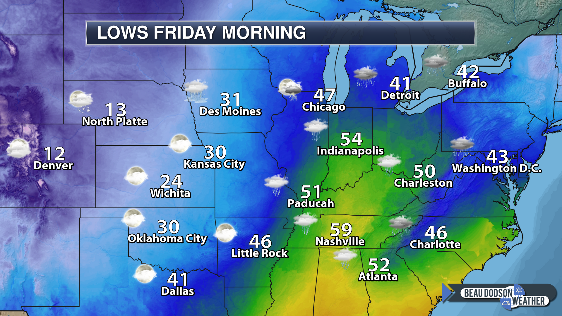
Friday Forecast: Cloudy early. Becoming partly cloudy. Not as mild as it was on Thursday. Rain should have come to an end.
My confidence in the forecast verifying: Medium (50% confidence in the forecast)
Temperature range: MO ~ 45 to 50 IL ~ 48 to 54 KY ~ 50 to 55 TN ~ 50 to 55
Wind chill (feels like) temperature forecast:
What is the chance/probability of precipitation? MO ~ 10% IL ~ 10% KY ~ 10% TN ~ 10%
Coverage of precipitation: Most likely none.
Is flash flooding anticipated? No
Is accumulating snow or ice anticipated? No
Is non-accumulating snow or ice anticipated? No
Are icy road conditions anticipated? No
Wind direction and speed: Becoming west and northwest at 7 to 14 mph and gusty
What impacts are anticipated from the weather? None
Is severe weather expected? No
The NWS officially defines severe weather as 58 mph wind or great, 1″ hail or larger, and/or tornadoes
Will lightning be possible? No
Should I cancel my outdoor plans? No
Will the weather impact my outdoor plans? It may be damp because of the Thursday and Thursday night rain event. Otherwise, no other impacts.
UV Index: 2 Low
Sunrise: 7:09 AM
Friday Night Forecast Details:
Forecast: Mostly clear. Colder. Patchy fog possible.
My confidence in the forecast verifying: Medium (60% confidence in the forecast)
Temperature range: MO ~ 25 to 30 IL ~ 28 to 32 KY ~ 28 to 34 TN ~ 30 to 34
Wind chill (feels like) temperature forecast: 22 to 30
What is the chance/probability of precipitation? MO ~ 0% IL ~ 0% KY ~ 0% TN ~ 0%
Coverage of precipitation: None
Is flash flooding anticipated? No
Is accumulating snow or ice anticipated? No
Is non-accumulating snow or ice anticipated? No
Are icy road conditions anticipated? No
Wind direction and speed: North and northwest at 5 to 10 mph
What impacts are anticipated from the weather? Monitor the risk of fog. Lower visibility in areas with fog.
Is severe weather expected? No
The NWS officially defines severe weather as 58 mph wind or great, 1″ hail or larger, and/or tornadoes
Will lightning be possible? No
Should I cancel my outdoor plans? No
Will the weather impact my outdoor plans? Fog could cause some issues late at night. If temperatures are cold enough then a few slick spots could form on roadways.
Sunset: 4:45 PM
Moonrise: 11:46 PM Waning Gibbous
Moonset: 11:43 AM
December 29, 2018
Saturday Forecast: Partly cloudy. Colder.
My confidence in the forecast verifying: Medium (60% confidence in the forecast)
Temperature range: MO ~ 38 to 44 IL ~ 38 to 44 KY ~ 38 to 44 TN ~ 40 to 45
Wind chill (feels like) temperature forecast: 30 to 40
What is the chance/probability of precipitation? MO ~ 0% IL ~ 0% KY ~ 0% TN ~ 0%
Coverage of precipitation: None
Is flash flooding anticipated? No
Is accumulating snow or ice anticipated? No
Is non-accumulating snow or ice anticipated? No
Are icy road conditions anticipated? No
Wind direction and speed: North at 5 to 10 mph
What impacts are anticipated from the weather? Early morning fog could lower visibility.
Is severe weather expected? No
The NWS officially defines severe weather as 58 mph wind or great, 1″ hail or larger, and/or tornadoes
Will lightning be possible? No
Should I cancel my outdoor plans? No
Will the weather impact my outdoor plans? Chilly conditions may make it uncomfortable for those outdoors. Typical December cold.
UV Index: 2 Low
Sunrise: 7:09 AM
Saturday Night Forecast Details:
Forecast: A fast-moving system will produce some clouds Saturday night and Sunday. This system may push through the region dry. some models produce hints of a light wintry mix. I will monitor trends and update as needed.
My confidence in the forecast verifying: Medium (40% confidence in the forecast)
Temperature range: MO ~ 28 to 34 IL ~ 28 to 32 KY ~ 28 to 34 TN ~ 30 to 34
Wind chill (feels like) temperature forecast: 24 to 30
What is the chance/probability of precipitation? MO ~ 20% IL ~ 20% KY ~ 20% TN ~ 20%
Coverage of precipitation: None to isolated
Is flash flooding anticipated? No
Is accumulating snow or ice anticipated? No
Is non-accumulating snow or ice anticipated? Small chance
Are icy road conditions anticipated? No
Wind direction and speed: Variable at 4 to 8 mph
What impacts are anticipated from the weather? None to a few wet roadways.
Is severe weather expected? No
The NWS officially defines severe weather as 58 mph wind or great, 1″ hail or larger, and/or tornadoes
Will lightning be possible? No
Should I cancel my outdoor plans? No
Will the weather impact my outdoor plans? Most likely no but monitor updates.
Sunset: 4:45 PM
Moonrise: 11:56 PM Waning Gibbous
Moonset: 12:15 PM
December 30, 2018
Sunday Forecast: A fast-moving system will produce some clouds Saturday night and Sunday. This system may push through the region dry. I am monitoring the rain chances. Morning clouds. A slight chance of rain or rain/snow showers. Clearing. Cool.
My confidence in the forecast verifying: Low (30% confidence in the forecast)
Temperature range: MO ~ 38 to 44 IL ~ 38 to 42 KY ~ 40 to 45 TN ~ 42 to 45
Wind chill (feels like) temperature forecast:
What is the chance/probability of precipitation? MO ~ 20% IL ~ 20% KY ~ 20% TN ~ 20%
Coverage of precipitation: None to isolated
Is flash flooding anticipated? No
Is accumulating snow or ice anticipated? No
Is non-accumulating snow or ice anticipated? Small chance
Are icy road conditions anticipated? No
Wind direction and speed: Becoming north and west at 6 to 12 mph
What impacts are anticipated from the weather? Most likely none but monitor updates
Is severe weather expected? No
The NWS officially defines severe weather as 58 mph wind or great, 1″ hail or larger, and/or tornadoes
Will lightning be possible? No
Should I cancel my outdoor plans? No
Will the weather impact my outdoor plans? Most likely no
UV Index: 2 Low
Sunrise: 7:09 AM
Sunday Night Forecast Details:
Forecast: Increasing clouds. A chance of a wintry mix.
My confidence in the forecast verifying: Medium (50% confidence in the forecast)
Temperature range: MO ~ 30 to 34 IL ~ 28 to 32 KY ~ 28 to 34 TN ~ 30 to 34
Wind chill (feels like) temperature forecast: 20 to 25
What is the chance/probability of precipitation? MO ~ 20% IL ~ 20% KY ~ 20% TN ~ 20%
Coverage of precipitation: Widely scattered
Is flash flooding anticipated? No
Is accumulating snow or ice anticipated? Monitor updates
Is non-accumulating snow or ice anticipated?
Are icy road conditions anticipated? Monitor updates
Wind direction and speed: South and southwest at 5 to 10 mph
What impacts are anticipated from the weather? Some wintry mix may develop Sunday night and Monday morning. Monitor updates. Low confidence on this event.
Is severe weather expected? No
The NWS officially defines severe weather as 58 mph wind or great, 1″ hail or larger, and/or tornadoes
Will lightning be possible? No
Should I cancel my outdoor plans? No
Will the weather impact my outdoor plans? Monitor updates
Sunset: 4:46 PM
Moonrise: 12:46 AM Last Quarter
Moonset: 12:47 PM
December 31, 2018
Monday Forecast: Cloudy. A chance of a wintry mix changing to rain.
My confidence in the forecast verifying: LOW (30% confidence in the forecast)
Temperature range: MO ~ 44 to 48 IL ~ 44 to 48 KY ~ 46 to 50 TN ~ 46 to 50
Wind chill (feels like) temperature forecast:
What is the chance/probability of precipitation? MO ~ 30% IL ~ 30% KY ~ 30% TN ~ 30%
Coverage of precipitation: Widely scattered
Is flash flooding anticipated? No
Is accumulating snow or ice anticipated? Monitor updates
Is non-accumulating snow or ice anticipated?
Are icy road conditions anticipated? Monitor updates
Wind direction and speed: South at 5 to 10 mph
What impacts are anticipated from the weather? Wet roadways are possible. I will monitor Monday morning conditions in case a wintry mix occurs.
Is severe weather expected? No
The NWS officially defines severe weather as 58 mph wind or great, 1″ hail or larger, and/or tornadoes
Will lightning be possible? No
Should I cancel my outdoor plans? I would not cancel. I would suggest monitoring updates.
Will the weather impact my outdoor plans? Some wintry mix or rain showers would cause damp conditions. Monitor updates.
UV Index: 2 Low
Sunrise: 7:10 AM
My apologies. Yesterday the Monday/Tuesday update did not load for some reason and an old forecast showed up.
That has been corrected.
There is a fast-moving system that arrives Monday night/Tuesday. For now, confidence on this system producing precipitation is low. Monitor updates.
Monday Night Forecast Details:
Forecast: Cloudy. A slight chance of rain showers or a wintry mix. Low confidence in this event.
My confidence in the forecast verifying: LOW (20% confidence in the forecast)
Temperature range: MO ~ 26 to 32 IL ~ 28 to 34 KY ~ 30 to 34 TN ~ 30 to 34
Wind chill (feels like) temperature forecast: 20 to 25
What is the chance/probability of precipitation? MO ~ 20% IL ~ 20% KY ~ 30% TN ~ 30%
Coverage of precipitation: Monitor updates
Is flash flooding anticipated? No
Is accumulating snow or ice anticipated? Monitor updates
Is non-accumulating snow or ice anticipated?
Are icy road conditions anticipated? Monitor updates
Wind direction and speed: Northwest at 5 to 10 mph
What impacts are anticipated from the weather? Low confidence. Monitor precipitation chances. Some wet roadways are possible. If temperatures drop enough then monitor the risk of icy patches.
Is severe weather expected? No
The NWS officially defines severe weather as 58 mph wind or great, 1″ hail or larger, and/or tornadoes
Will lightning be possible? No
Should I cancel my outdoor plans? I would not cancel plans. I would monitor updates.
Will the weather impact my outdoor plans? I will be monitoring the chance of a wintry mix.
Sunset: 4:47 PM
Moonrise: 1:54 AM Waning Crescent
Moonset: 1:20 PM
January 1, 2018
Tuesday Forecast: Mostly cloudy. A chance of rain or a wintry mix.
My confidence in the forecast verifying: LOW (30% confidence in the forecast)
Temperature range: MO ~ 36 to 42 IL ~ 38 to 44 KY ~ 38 to 44 TN ~ 38 to 44
Wind chill (feels like) temperature forecast: 25 to 35
What is the chance/probability of precipitation? MO ~ 20% IL ~ 20% KY ~ 30% TN ~ 30%
Coverage of precipitation: Monitor
Is flash flooding anticipated? No
Is accumulating snow or ice anticipated? Monitor
Is non-accumulating snow or ice anticipated? Monitor
Are icy road conditions anticipated? Monitor
Wind direction and speed: Northwest at 6 to 12 mph
What impacts are anticipated from the weather? Monitor
Is severe weather expected? No
The NWS officially defines severe weather as 58 mph wind or great, 1″ hail or larger, and/or tornadoes
Will lightning be possible? No
Should I cancel my outdoor plans? Monitor
Will the weather impact my outdoor plans? Monitor
UV Index: 2 Low
Sunrise: 7:10 AM
Tuesday Night Forecast Details:
Forecast: Mostly clear. Chilly. Patchy fog.
My confidence in the forecast verifying: Medium (50% confidence in the forecast)
Temperature range: MO ~ 22 to 26 IL ~ 22 to 26 KY ~ 22 to 26 TN ~ 22 to 26
Wind chill (feels like) temperature forecast: 20 to 25
What is the chance/probability of precipitation? MO ~ 0% IL ~ 0% KY ~ 0% TN ~ 0%
Coverage of precipitation: None
Is flash flooding anticipated? No
Is accumulating snow or ice anticipated? No
Is non-accumulating snow or ice anticipated? No
Are icy road conditions anticipated? No
Wind direction and speed:
What impacts are anticipated from the weather? Patchy fog could reduce visibility
Is severe weather expected? No
The NWS officially defines severe weather as 58 mph wind or great, 1″ hail or larger, and/or tornadoes
Will lightning be possible? No
Should I cancel my outdoor plans? No
Will the weather impact my outdoor plans? No
Sunset: 4:48 PM
Moonrise: 2:56 AM Waning Crescent
Moonset: 1:53 PM
.
January 2, 2018
Wednesday Forecast: Mostly sunny. Chilly.
My confidence in the forecast verifying: Medium (40% confidence in the forecast)
Temperature range: MO ~ 35 IL ~ 35 KY ~ 36 TN ~ 38
Wind chill (feels like) temperature forecast: 30 to 40
What is the chance/probability of precipitation? MO ~ 0% IL ~ 0% KY ~ 0% TN ~ 0%
Coverage of precipitation: None
Is flash flooding anticipated? No
Is accumulating snow or ice anticipated? No
Is non-accumulating snow or ice anticipated? No
Are icy road conditions anticipated? No
Wind direction and speed: North at 7 to 14 mph
What impacts are anticipated from the weather? None
Is severe weather expected? No
The NWS officially defines severe weather as 58 mph wind or great, 1″ hail or larger, and/or tornadoes
Will lightning be possible? Yes
Should I cancel my outdoor plans? No
Will the weather impact my outdoor plans? None
UV Index: 2 Low
Sunrise: 7:10 AM
Wednesday Night Forecast Details:
Forecast: Mostly clear. Patchy fog. Chilly.
My confidence in the forecast verifying: Medium (40% confidence in the forecast)
Temperature range: MO ~ 25 to 30 IL ~ 26 to 30 KY ~ 28 to 34 TN ~ 30 to 34
Wind chill (feels like) temperature forecast: 25 to 30
What is the chance/probability of precipitation? MO ~ 0% IL ~ 0% KY ~ 0% TN ~ 0%
Coverage of precipitation: None
Is flash flooding anticipated? No
Is accumulating snow or ice anticipated? No
Is non-accumulating snow or ice anticipated? No
Are icy road conditions anticipated? No
Wind direction and speed: North at 3 to 6 mph
What impacts are anticipated from the weather? Monitor fog conditions for lower visibility.
Is severe weather expected? No
The NWS officially defines severe weather as 58 mph wind or great, 1″ hail or larger, and/or tornadoes
Will lightning be possible? No
Should I cancel my outdoor plans? No
Will the weather impact my outdoor plans? Most likely no. Monitor fog.
Sunset: 4:49 PM
Moonrise: 3:56 AM Waning Crescent
Moonset: 2:30 PM
Learn more about the UV index readings. Click here.
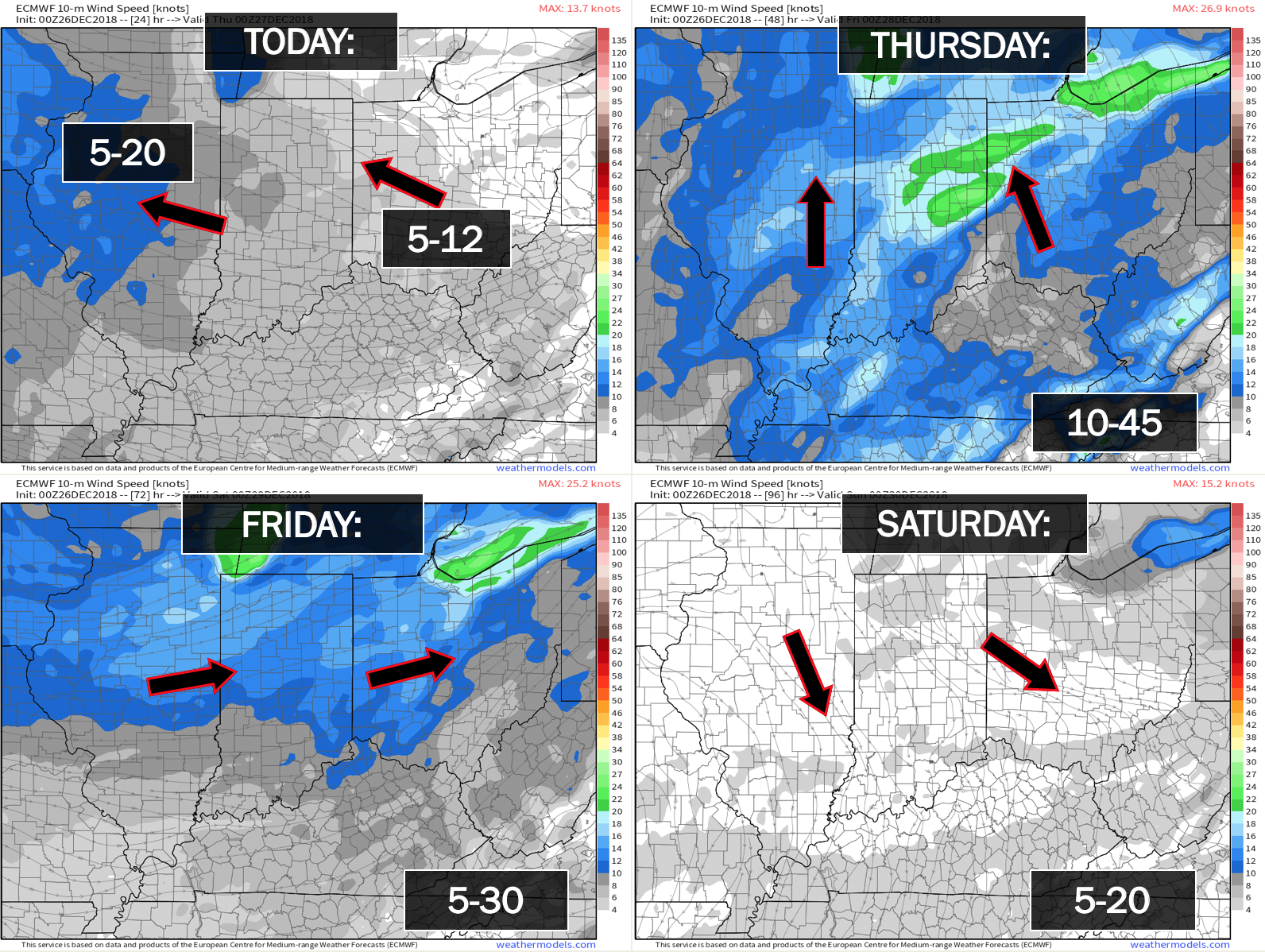
Wind forecast
Click to enlarge
.

Wednesday: Wintry precipitation is not anticipated.
Thursday: Wintry precipitation is not anticipated.
Friday: Wintry precipitation is not anticipated.
Saturday: Dry on Saturday. Late Saturday night a fast moving system could produce a light wintry mix. This system has little in the way of moisture to work with. It may end up completely dry.
Sunday: Most likely no precipitation. I will monitor late Saturday night/early Sunday morning.
Monday and Monday night: Two fast moving systems could produce some light wintry mix.
Tuesday: For now, the risk of wintry precipitation appears low. I am closely monitoring a storm system that could produce precipitation Monday night and Tuesday. Questions remain on track and inensity. Monitor updates.
Wednesday: Wintry precipitation is not anticipated.
Wednesday night and Thursday: A fast-moving clipper may bring some precipitation into the area. Monitor updates. Low confidence this far out.

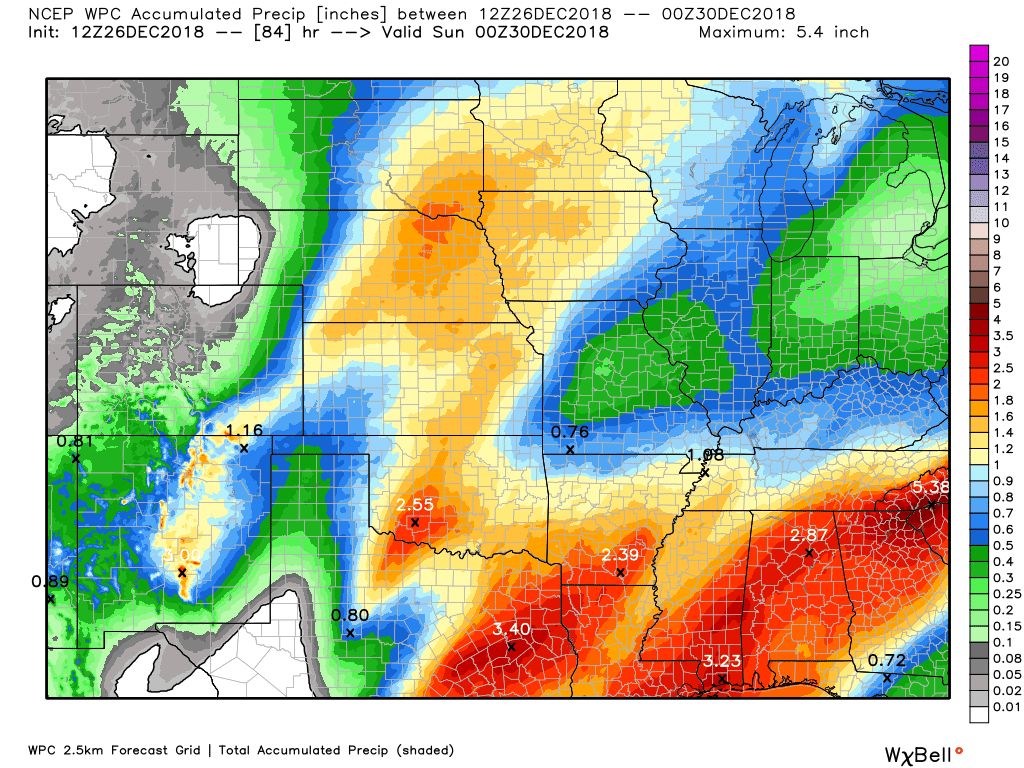
Here is the WPC/NOAA rainfall outlook.
Click to enlarge graphics on the blog.
Widespread rain is forecast to develop tonight into Thursday night. Some moderate rain will be possible.
If thunderstorms develop then locally higher totals are likely to occur.
Subscribers, do you need a forecast for an outdoor event?

Did you know that you can find me on Twitter?


We offer interactive local city live radars and regional radars.
If a radar does not update then try another one. If a radar does not appear to be refreshing then hit Ctrl F5 on your keyboard.
You may also try restarting your browser. The local city view radars also have clickable warnings.
During the winter months, you can track snow and ice by clicking the winterize button on the local city view interactive radars.

Questions? Broken links? Other questions?
You may email me at beaudodson@usawx.com

The National Weather Service defines a severe thunderstorm as one that produces quarter size hail or larger, 58 mph winds or greater, and/or a tornado.
Wednesday through Thursday night: Thunderstorms are possible late Wednesday night and more likely Thursday and Thursday night. Monitor updates. There is a low end risk that a thunderstorm could produce strong wind gusts.
Friday through Wednesday: Severe weather is not anticipated.
Interactive live weather radar page. Choose the city nearest your location. If one of the cities does not work then try a nearby one. Click here.
National map of weather watches and warnings. Click here.
Storm Prediction Center. Click here.
Weather Prediction Center. Click here.

Live lightning data: Click here.

Interactive GOES R satellite. Track clouds. Click here.

Here are the latest local river stage forecast numbers Click Here.
Here are the latest lake stage forecast numbers for Kentucky Lake and Lake Barkley Click Here.

- Increasing clouds today
- Rain chances quickly ramp up tonight into Thursday
- Rain ends Thursday night
- Monitoring a couple of fast moving/weak systems this weekend into early next week
FORECAST
Today:
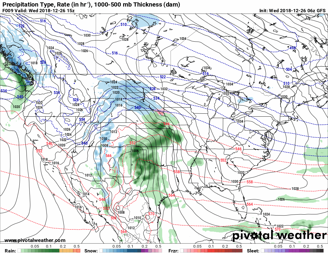
Today we find ourselves in-between weather systems.
Clouds will thicken through the day. A few rain showers may even spread into southeast Missouri during the afternoon hours. Smaller chances as you move east of the Mississippi River.
You can see the morning satellite view. Plenty of clouds pushing into the region.
Live satellite views. Click here
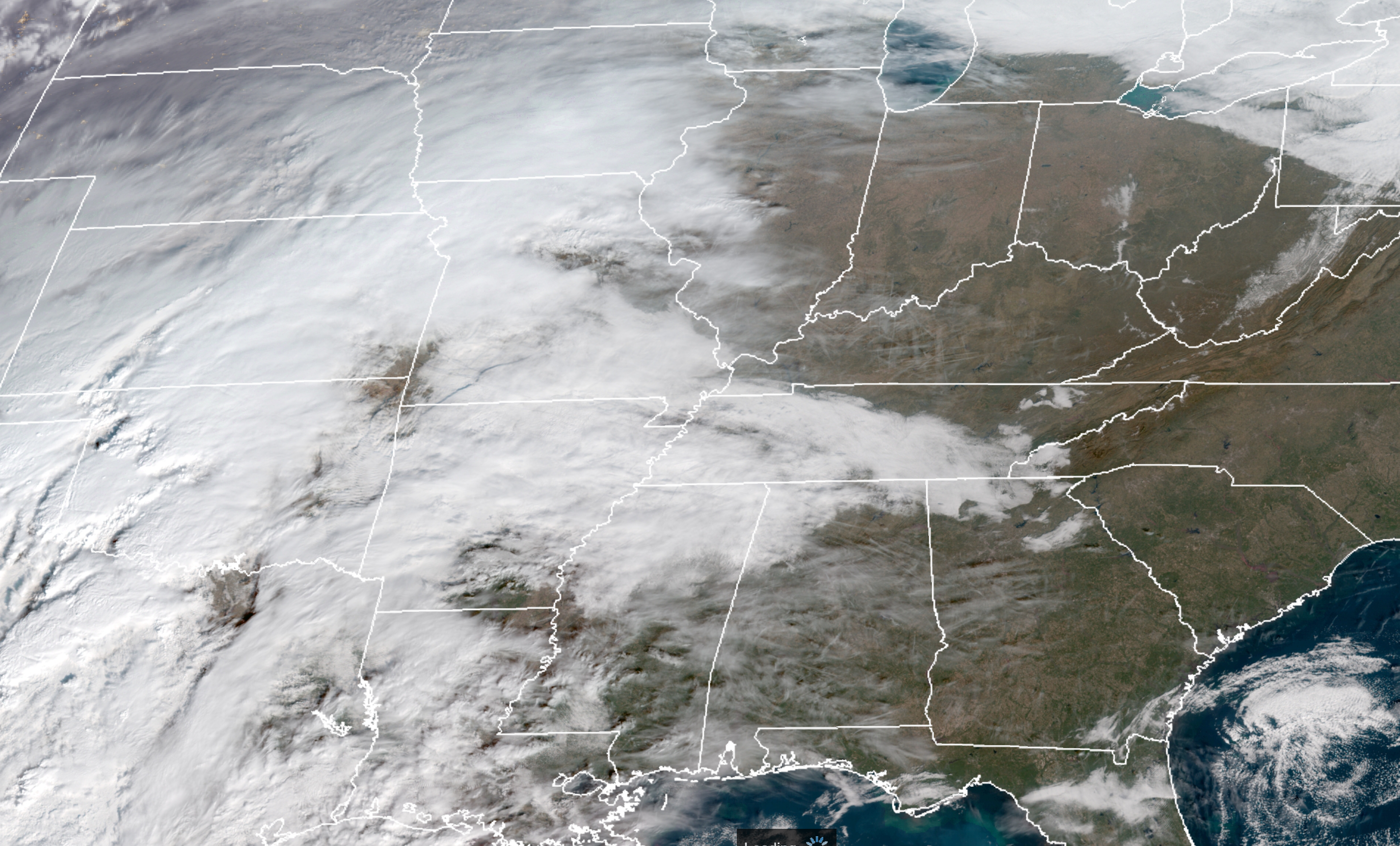
You can see the warm surge of air pushing northward from the Gulf of Mexico.
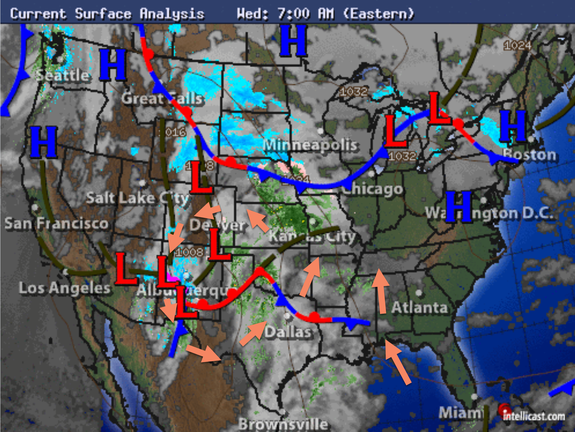
This is in response to a developing area of low pressure in the central United States.
You can see the red L’s to our west. That is low pressure. You can see the wind stream arrows moving northward.
Low pressure rotates counter-clockwise.
Tonight:
Tonight, in response to a deepening area of low pressure to our west, widespread showers will overspread the region. It will be warm enough for all liquid. Sorry, snow fans.
The rain will continue into Thursday evening.
A few thunderstorms are possible Thursday. We will have a strong low-level jet about 5000′ aloft. If thunderstorms form then they could tap into some of these winds and bring them to the surface.
The overall risk of severe weather is low/limited.
I can’t rule out a thunderstorm producing high winds. That would be the exception vs the norm.
We will be in the warm sector of this storm system. That means the snow will remain well to our north and northwest. Blizzard conditions are possible across portions of the central and northern plains.
Here is the NAM model-guidance future-cast radar. You can see how it tracks the rain showers across our region.
It is possible that the bulk of the rain will occur before 3 PM on Thursday. The rain should diminish from west to east during Thursday afternoon.
The cold front will remain to our west during the afternoon and evening hours. A few additional thunderstorms could form along the front. This will need to be monitored.
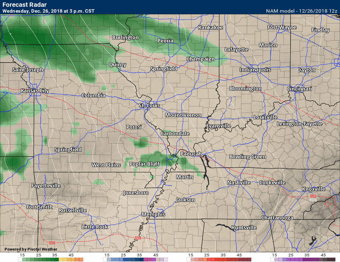
The rain will come to an end as we move deeper into Thursday night. It will also turn colder behind the cold front.
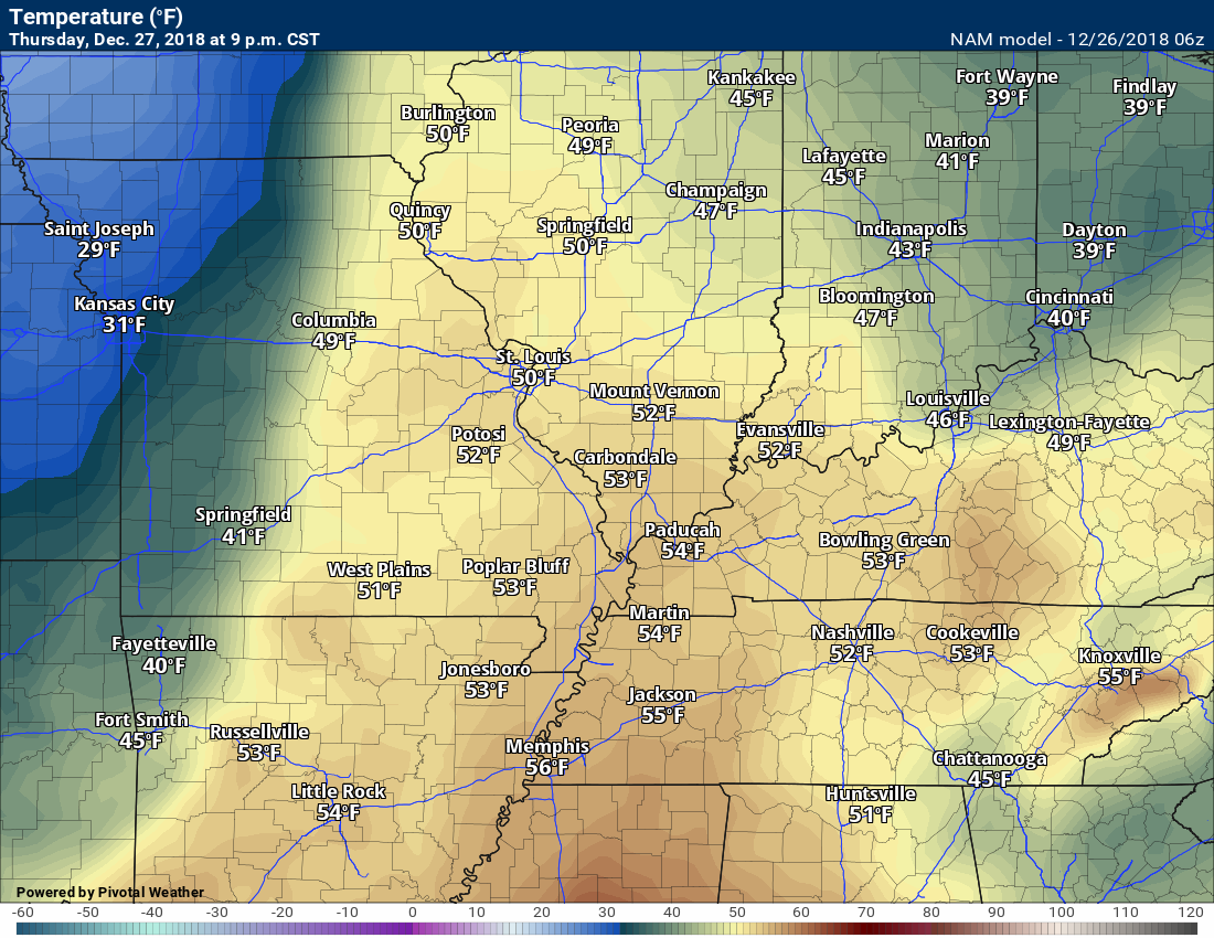
Here are the temperature forecast numbers for Thursday evening.
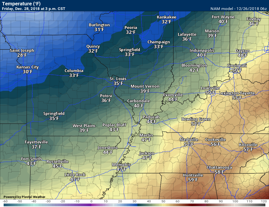
Here are the forecast numbers for Friday afternoon. Turning somewhat cooler. Nothing extreme.
Here is the GFS model guidance animation of this event. I wanted to show you the heavy snow well to our north, as well.
This will be a big snow event for some. I would not be surprised if some areas receive more than 15 inches of snow!
Click to enlarge.
The blue represents snow. Dark blue would be heavy snow.
Green, dark green, yellow, and orange represents varying intensities of rain. Yellow and orange are heavier rain than the greens.
Pink are the winter storm warning zones. Some areas may be upgraded to a blizzard warning.
Here is the snow totals forecast map that the long range team made earlier this morning. Sorry, snow lovers. YOu will have to travel north to find your white gold.

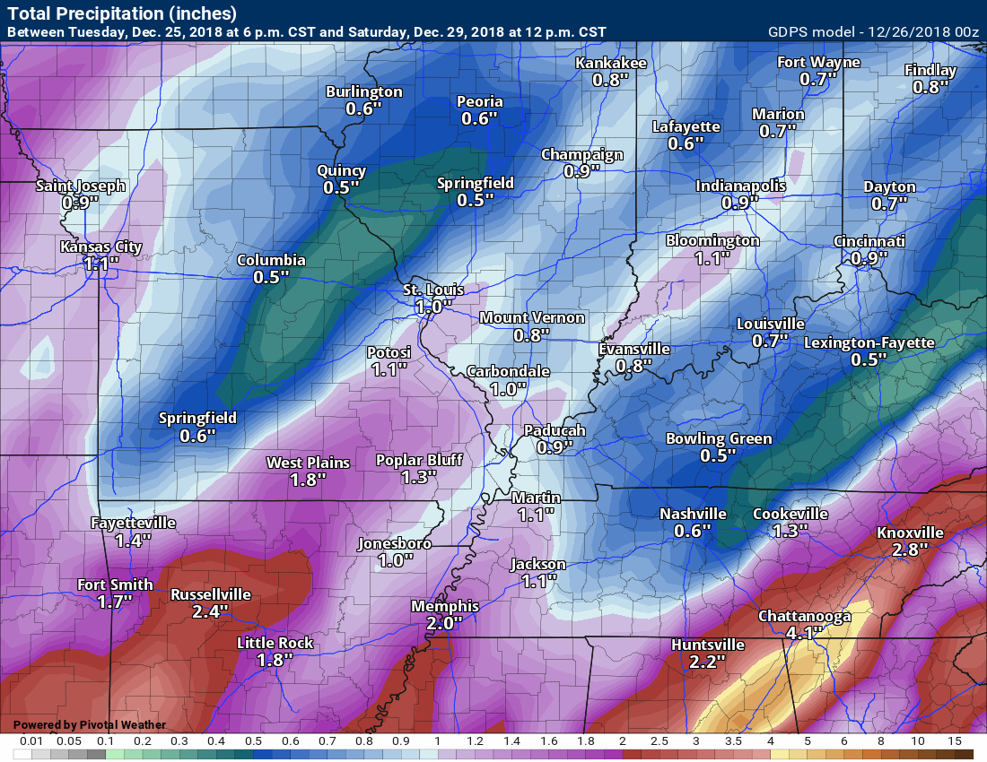
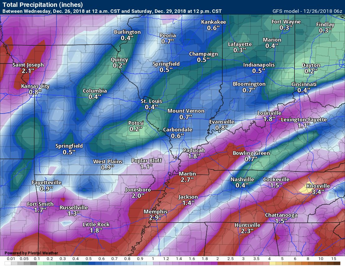
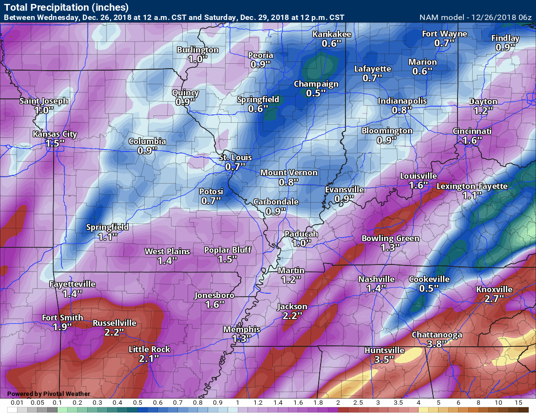
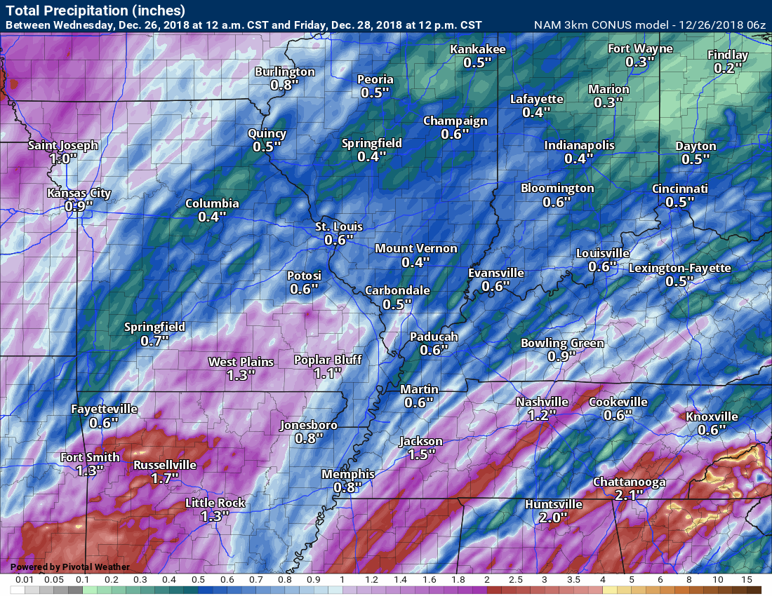
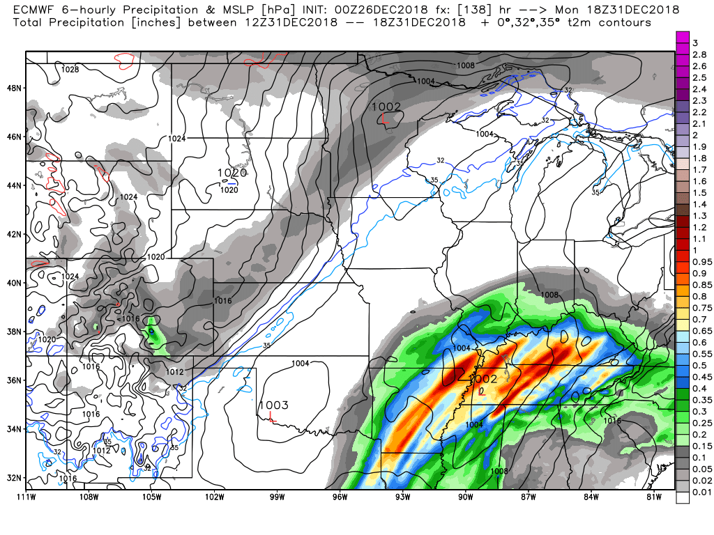
Here are the model predictions on rainfall totals. They vary. These are also higher than the WPC/NOAA are calling for.
The risk of heavier rain my center on the risk of thunderstorms. Thunderstorms would produce higher rain totals.
I am expecting a widespread 0.40″ and 0.80″ of rain. Again, thunderstorms will produce higher totals.
This is the Canadian model guidance.
This is the GFS model guidance
This is the NAM model guidance.
This is the high-resolution NAM model guidance.
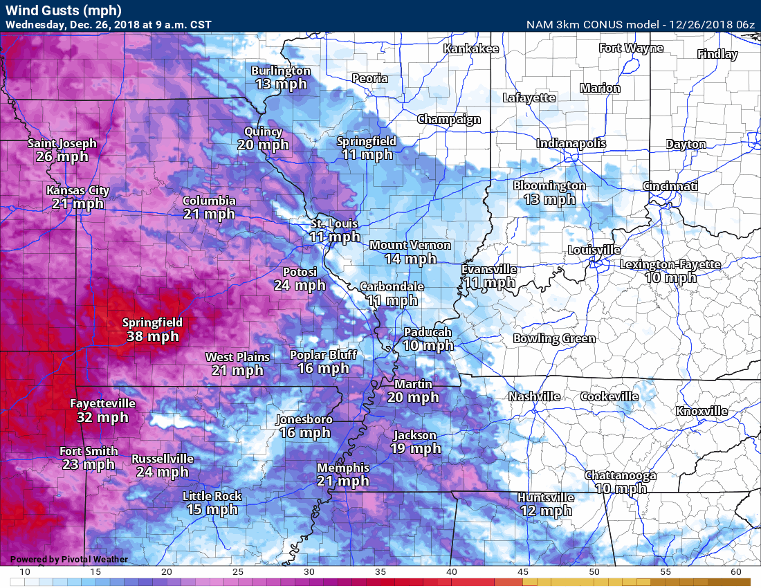
This system will have a tight pressure gradient. Pressure would be barometric pressure. Those barometers on your wall will show falling pressure. A tight pressure gradient will mean strong and gusty winds.
The highest winds will occur Thursday and Thursday night. Some areas will top 40 mph.
The NAM model goes hog wild with wind numbers.
I doubt they will be quite this high but you get a general idea that some strong winds will occur as this system pushes eastward.
Friday into Tuesday
Calm weather returns by Friday and that will last into Saturday evening. It will be cooler.
Our next two weather makers will be fast-moving and weak. They will struggle to find enough moisture to produce precipitation.
One of those will arrive Saturday night/Sunday morning. That system won’t have much moisture to work with. Plan on some clouds Saturday night and perhaps a slight chance of light rain or a wintry mix. It is possible that no precipitation develops.
Another system arrives Monday and Monday night. Some scattered rain or snow/wintry mix showers will be possible with it, as well. It may have a bit more moisture to work with. Monitor updates on this system. Confidence in the details remains low.
The EC model guidance is bullish on precipitation for event number two. Other model guidance disagrees.
Here is what the EC model shows for six-hour rain totals ending at 12 PM Monday.
The Canadian model takes the system further south and misses most of us.
Green represents the rain. This is 12 AM Tuesday morning.
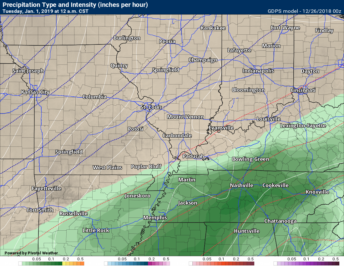
The GFS is mostly dry.
I will monitor the trends in guidance concerning the Monday/Monday night precipitation event. I am sure there will be adjustments moving forward.
Temperature Anomalies
Let’s look at the temperature anomaly forecast map from the GFS model guidance.
Red colors indicate above normal temperatures. Blue colors represent below normal temperatures.
The time-stamp is located in the upper left portion of the map animation.
Those orange and brown colors are WELL above normal temperatures.
I am watching the first two weeks of January for some cold shots. Time will tell.
Click to enlarge. Date stamp upper left.

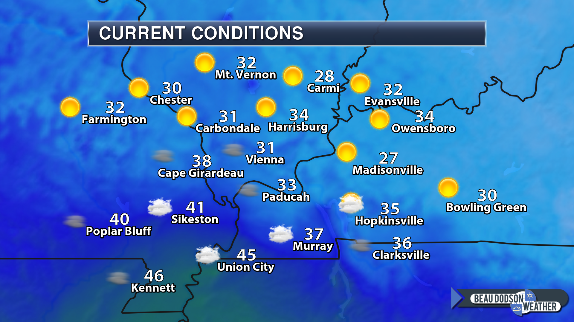
Temperatures at 8 AM this morning were chilly.
![]()

I bring these to you from the BAMwx team. They are excellent long-range forecasters.
Remember, long-range outlooks are a bit of skill, understanding weather patterns, and luck combined. It is not an exact science.

This product is for subscribers.
Subscribe at www.weathertalk.com
Subscriber graphics can be viewed on this page CLICK HERE

This product is for subscribers.

This product is for subscribers.
Subscribe at www.weathertalk.com
Subscriber graphics can be viewed on this page CLICK HERE
![]()
.
Winter Outlook!
These products are for subscribers.
December temperature and precipitation outlook
January temperature outlook
February temperature outlook
Winter snow outlook
.These products are for subscribers.
![]()

A new weather podcast is now available! Weather Geeks (which you might remember is on The Weather Channel each Sunday)
To learn more visit their website. Click here.
![]()

WeatherBrains Episode 674
Tonight’s Guest Panelist is a meteorologist recently retired as MIC from the NWS Birmingham. Jim Stefkovitch, welcome to the show!
Our second Guest Panelist is the MIC of the NWS in Atlanta. Keith Stellman, welcome to the show!
Tonight’s Guest WeatherBrain is a Professional of Sociology at Northwestern University. His PhD is from Harvard, and he has received numerous fellowships. In fact, he is probably the smartest person we have ever had on the show. Dr. Gary Alan Fine, welcome to WeatherBrains.
Other discussions in this weekly podcast include topics like:
- TV meteorologist tragically lost to suicide
- The role of politics in the day-to-day operations of the NWS
- Upcoming 5th anniversary of “Snowmageddon”
- Astronomy Outlook with Tony Rice
- and more!
Link to their website https://weatherbrains.com/
Previous episodes can be viewed by clicking here.

We offer interactive local city live radars and regional radars. If a radar does not update then try another one. If a radar does not appear to be refreshing then hit Ctrl F5. You may also try restarting your browser.
The local city view radars also have clickable warnings.
During the winter months, you can track snow and ice by clicking the winterize button on the local city view interactive radars.
You may email me at beaudodson@usawx.com
Find me on Facebook!

Find me on Twitter!

Did you know that a portion of your monthly subscription helps support local charity projects?
You can learn more about those projects by visiting the Shadow Angel Foundation website and the Beau Dodson News website.

I encourage subscribers to use the app vs regular text messaging. We have found text messaging to be delayed during severe weather. The app typically will receive the messages instantly. I recommend people have three to four methods of receiving their severe weather information.
Remember, my app and text alerts are hand typed and not computer generated. You are being given personal attention during significant weather events.
