Christmas snow update.
Click the winterize button on the city-view live radars. That will show you the lighter snow echoes.
Interactive Weather Radar Page. Choose the city nearest your location: Click this link
I am tracking multiple snow chances over the next 14 days.
Winter has arrived. We will have cold weather all week. Below normal temperatures.
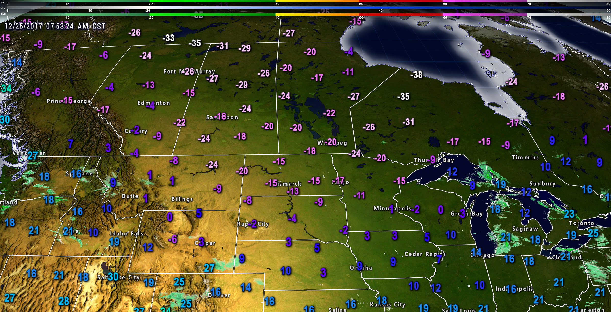
Check out these Christmas morning air temperatures. These are not wind chills. Brrr
Click to enlarge
.
.
Wind chills on Wednesday night and Thursday night could be in the single digits. Some data indicates below zero wind chills. Brrr will be the word.
Actual air temperatures will depend on whether we have snow on the ground. If we have snow on the ground then lows will dip into the single digits to lower teens. Without the snow I am forecasting temperatures to drop into the teens on Tuesday night, Wednesday night, and perhaps Thursday night.
Even colder temperatures are possible late this weekend into early next week.
Here is the Wednesday and Thursday morning wind chill maps.
Click images to enlarge
.
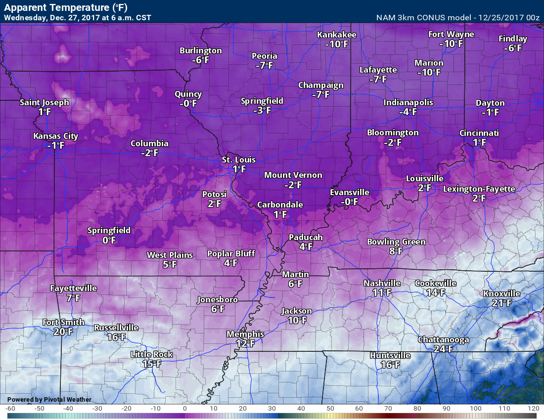
.
Thursday morning
.
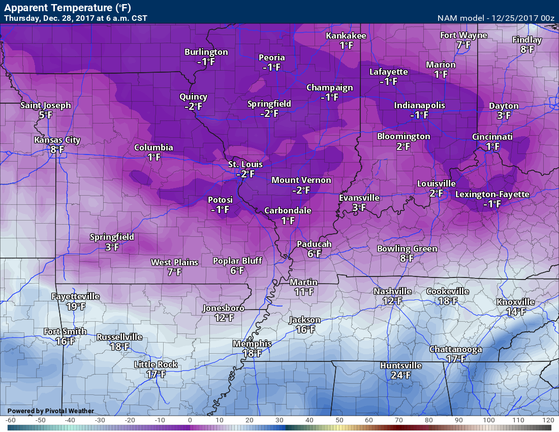
.
Snow probability maps
The probabilities will be adjusted as each event comes into view. The probability numbers will never be all that high days in advance of an event. Winter precipitation is difficult to forecast a day or two in advance, let alone a week in advance.
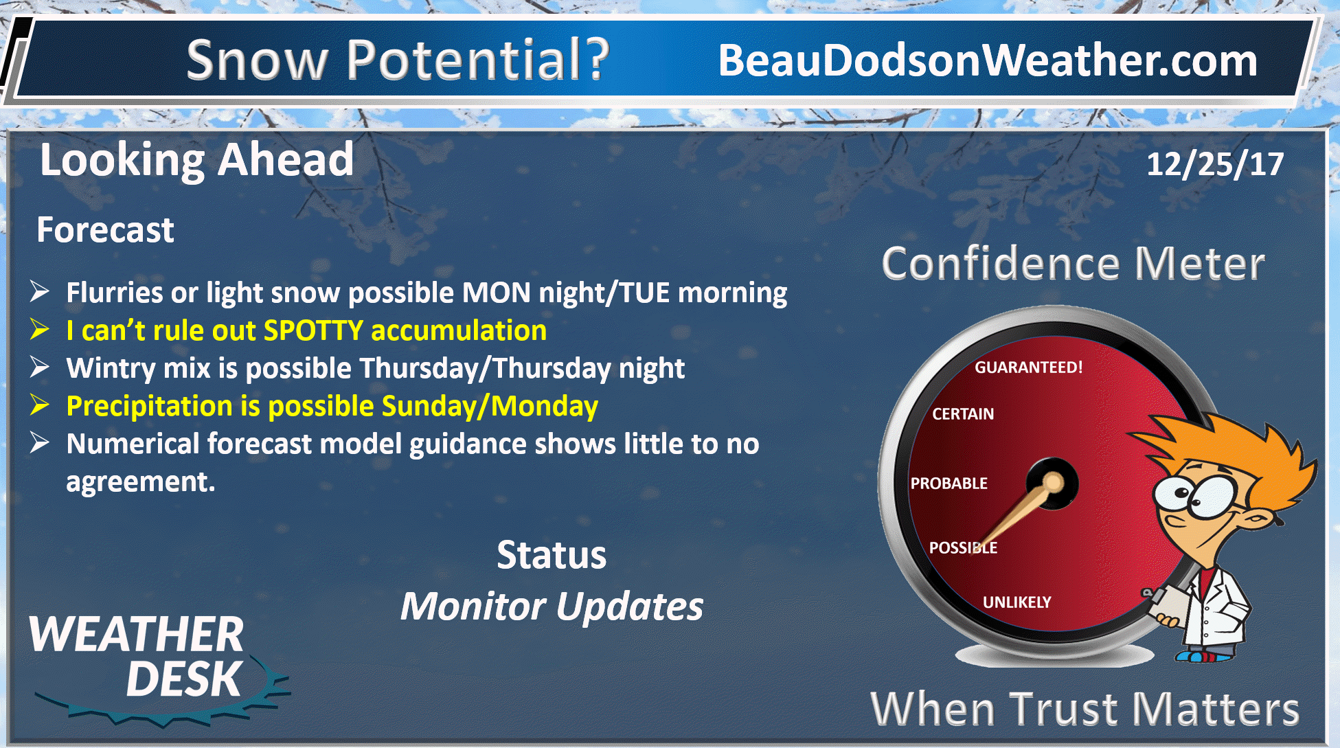
Forecast:
A weak system will push into the area tonight (Christmas night). This disturbance may have just enough moisture and lift to produce a period of light snow flurries and spotty snow showers.
This is the type of situation where some areas could receive a light accumulation and neighboring areas may not. Think of summer showers.
Snow showers are likely later tonight and especially tonight, but it is not a given that everyone will receive accumulation.
It will be cold enough for the snow to stick to surfaces. This is not a slam dunk forecast. Model guidance ranges from no snow to an inch or two.
I increased my probability numbers for Christmas night (see below).
Here is the future-cast NAM radar. Again, spotty snow showers. Light accumulation possible. Not a slam dunk forecast. Remember those three comments.
.

.
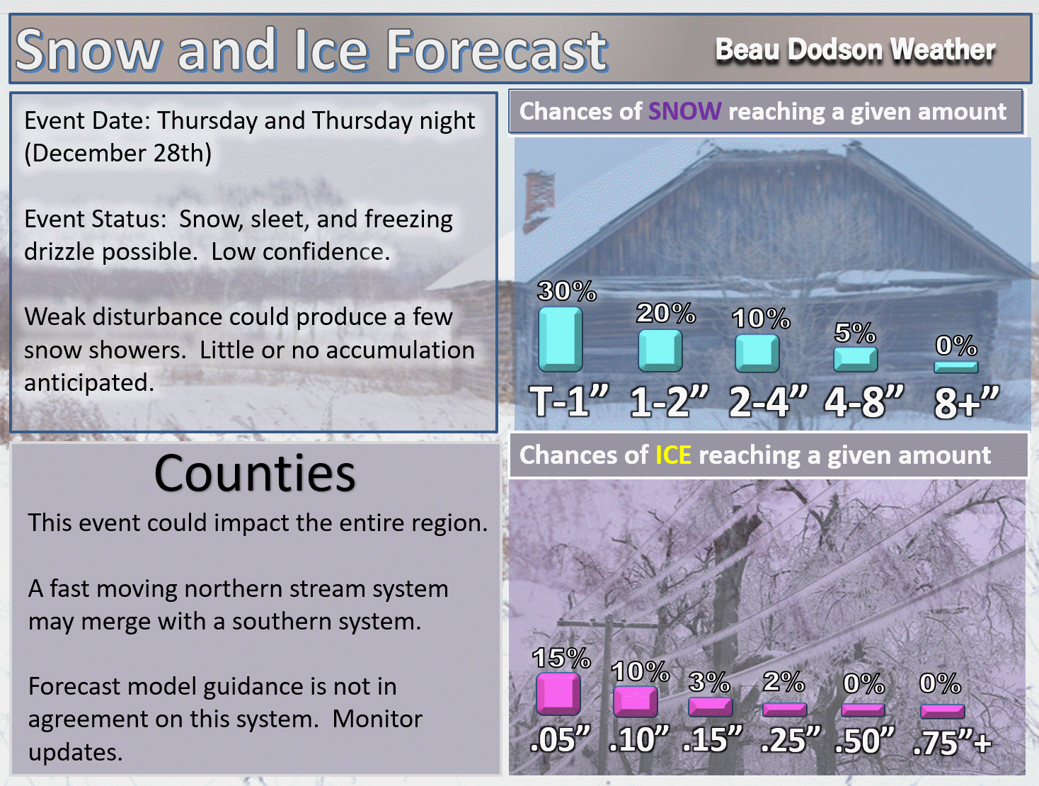
A stronger system could bring precipitation into the region on Thursday and Thursday night.
Another system may bring precipitation next Sunday/Monday. Monitor updates.
Confidence on the Thursday and Sunday system remains low. I hope to have a better handle on the forecast by Tuesday night.
Here are my current snow probability numbers.
.
.

.
.
.
Monitor updates through the week. We do have a decent chance of wintry precipitation between now and the first few days of January.
Where you see LOW confidence, that means significant adjustments in the forecast are possible.
December 25, 2017
Monday Forecast Details
Forecast: Some morning sun. Increasing clouds during the day. Cold. Flurries possible late in the day.
Temperatures: MO ~ 30 to 35 IL ~ 30 to 35 KY ~ 34 to 38
What is the chance of precipitation? MO ~ 20% IL ~ 20% KY ~ 20%
Coverage of precipitation: None to isolated
Wind chill values: Upper teens to upper 20’s
Accumulating snow or ice: Unlikely
Winds: Variable at 5 to 10 mph
What impacts are anticipated from the weather? Most likely none
My confidence in the forecast verifying: High
Is severe weather expected? No
The NWS defines severe weather as 58 mph wind or great, 1″ hail or larger, and/or tornadoes
Should I cancel my outdoor plans? No
.
Monday Night Forecast Details:
Forecast: Some snow accumulation is possible tonight and Tuesday. It might be spotty. Mostly cloudy. Cold. Spotty flurries or snow showers possible. I can’t rule out accumulation, but confidence is low to medium. Not a slam dunk forecast. A weak system could produce enough lift for snow showers to develop. It is possible that some areas receive accumulation and neighboring areas do not. The most likely area for snow would be our northern counties. Northern parts of southeast Missouri and northern parts of southern Illinois. Lesser chances as you go south.
Temperatures: MO ~ 18 to 24 IL ~ 16 to 24 KY ~ 22 to 26
What is the chance of precipitation? MO ~ 50% IL ~ 60% KY ~ 50%
Coverage of precipitation: Scattered
Wind chill values: 15 to 20
Accumulating snow or ice: There is a chance of spotty accumulation. Confidence is low to medium.
Winds: East and southeast at 4 to 8 mph
What impacts are anticipated from the weather? Monitoring light snow chances. Slick roadways possible if the snow does develop.
My confidence in the forecast verifying: Low to medium
Is severe weather expected? No
The NWS defines severe weather as 58 mph wind or great, 1″ hail or larger, and/or tornadoes
Should I cancel my outdoor plans: No, but monitor radars in case snow develops.
.
December 26, 2017
Tuesday Forecast Details
Forecast: A mix of sun and clouds. Cold. A few flurries or snow showers possible. Colder north vs south.
Temperatures: MO ~ 18 to 34 IL ~ 20 to 28 KY ~ 33 to 36
What is the chance of precipitation? MO ~ 20% IL ~ 30% KY ~ 30%
Coverage of precipitation: Isolated
Wind chill values: 15 to 25
Accumulating snow or ice: Unlikely. Dusting at most.
Winds: North and northeast at 5 to 10 mph
What impacts are anticipated from the weather? Most likely none. I will be watching for snow showers. Low wind chills.
My confidence in the forecast verifying: High
Is severe weather expected? No
The NWS defines severe weather as 58 mph wind or great, 1″ hail or larger, and/or tornadoes
Should I cancel my outdoor plans? Cold
.
Tuesday Night Forecast Details:
Forecast: Some clouds. A flurry possible. Bitterly cold. Low wind chills.
Temperatures: MO ~ 10 to 15 IL ~ 8 to 14 KY ~ 12 to 16
What is the chance of precipitation? MO ~ 10% IL ~ 10% KY ~ 10%
Coverage of precipitation: None to isolated
Wind chill values: -5 to 15
Accumulating snow or ice: No
Winds: North winds at 5 to 10 mph with gusts to 15
What impacts are anticipated from the weather? Cold wind chills
My confidence in the forecast verifying: High
Is severe weather expected? No
The NWS defines severe weather as 58 mph wind or great, 1″ hail or larger, and/or tornadoes
Should I cancel my outdoor plans: Bitterly cold
.
December 27, 2017
Wednesday Forecast Details
Forecast: Partly to mostly sunny. Cold.
Temperatures: MO ~ 22 to 26 IL ~ 22 to 26 KY ~ 24 to 28
What is the chance of precipitation? MO ~ 10% IL ~ 10% KY ~ 10%
Coverage of precipitation: Most likely none
Wind chill values: 5 above to 20 above
Accumulating snow or ice: No
Winds: North and northeast at 5 to 10 mph
What impacts are anticipated from the weather? Cold wind chills
My confidence in the forecast verifying: High
Is severe weather expected? No
The NWS defines severe weather as 58 mph wind or great, 1″ hail or larger, and/or tornadoes
Should I cancel my outdoor plans? Cold
.
Wednesday Night Forecast Details:
Forecast: Partly cloudy. Cold. Low wind chills.
Temperatures: MO ~ 8 to 14 IL ~ 8 to 12 KY ~ 10 to 15
What is the chance of precipitation? MO ~ 10% IL ~ 10% KY ~ 10%
Coverage of precipitation: Most likely none
Wind chill values: -5 to 10 above
Accumulating snow or ice: Unlikely
Winds: Northeast at 5 to 10 mph
What impacts are anticipated from the weather? Low wind chills.
My confidence in the forecast verifying: High
Is severe weather expected? No
The NWS defines severe weather as 58 mph wind or great, 1″ hail or larger, and/or tornadoes
Should I cancel my outdoor plans: Bitterly cold
.
December 28, 2017
Thursday Forecast Details
Forecast: A mix of sun and clouds.
Temperatures: MO ~ 26 to 32 IL ~ 26 to 32 KY ~ 28 to 34
What is the chance of precipitation? MO ~ 10% IL ~ 10% KY ~ 10%
Coverage of precipitation: Most likely none
Wind chill values: -5 to 15
Accumulating snow or ice: No
Winds: East and northeast at 5 to 10 mph with gusts to 15
What impacts are anticipated from the weather? Low wind chills.
My confidence in the forecast verifying: High
Is severe weather expected? No
The NWS defines severe weather as 58 mph wind or great, 1″ hail or larger, and/or tornadoes
Should I cancel my outdoor plans? Cold
.
Thursday Night Forecast Details:
Forecast: Partly cloudy and cold.
Temperatures: MO ~ 14 to 18 IL ~ 14 to 18 KY ~ 14 to 18
What is the chance of precipitation? MO ~ 10% IL ~ 10% KY ~ 10%
Coverage of precipitation: Most likely none
Wind chill values: -5 to 15
Accumulating snow or ice: No
Winds: North and northwest at 5 to 10 mph
What impacts are anticipated from the weather? Low wind chills.
My confidence in the forecast verifying: High
Is severe weather expected? No
The NWS defines severe weather as 58 mph wind or great, 1″ hail or larger, and/or tornadoes
Should I cancel my outdoor plans: Bitterly cold
.
December 29, 2017
Friday Forecast Details
Forecast: Partly sunny morning. Afternoon clouds. A few snow flurries or snow showers possible (esp southern Illinois into northwest Kentucky).
Temperatures: MO ~ 30 to 35 IL ~ 30 to 35 KY ~ 30 to 35
What is the chance of precipitation? MO ~ 10% IL ~ 30% KY ~ 30%
Coverage of precipitation: Isolated over our north and northeast counties
Wind chill values: 15 to 25
Accumulating snow or ice: Monitor updates
Winds: North and northwest at 5 to 10 mph with gusts to 18 mph
What impacts are anticipated from the weather? Cold wind chills. I will monitor the snow chances.
My confidence in the forecast verifying: Medium
Is severe weather expected? No
The NWS defines severe weather as 58 mph wind or great, 1″ hail or larger, and/or tornadoes
Should I cancel my outdoor plans? Cold
.
Friday Night Forecast Details:
Forecast: Cloudy and cold. Flurries or snow showers possible.
Temperatures: MO ~ 16 to 22 IL ~ 16 to 22 KY ~ 16 to 22
What is the chance of precipitation? MO ~ 20% IL ~ 30% KY ~ 30%
Coverage of precipitation: Isolated
Wind chill values: 5 to 15 degrees
Accumulating snow or ice: No
Winds: North at 5 to 10 mph
What impacts are anticipated from the weather? Monitor updates. Cold wind chills.
My confidence in the forecast verifying: Medium
Is severe weather expected? No
The NWS defines severe weather as 58 mph wind or great, 1″ hail or larger, and/or tornadoes
Should I cancel my outdoor plans: Cold
.
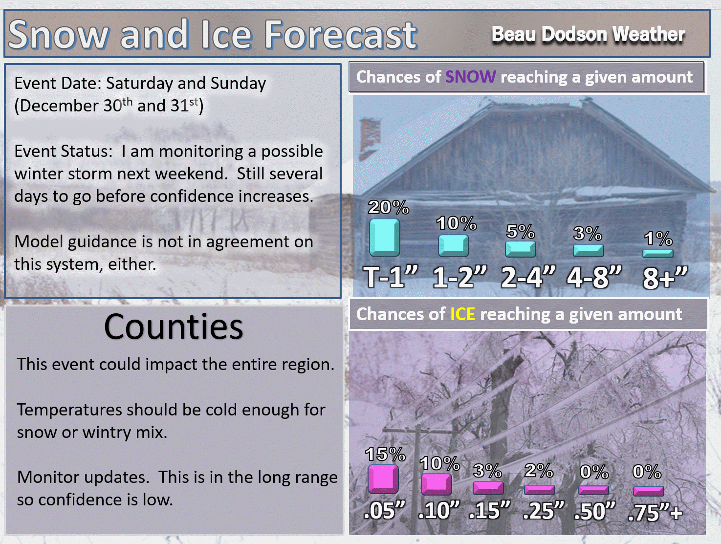
December 30, 2017
Saturday Forecast Details
Forecast: Partly sunny during the morning. Increasing afternoon clouds. I will monitor snow chances.
Temperatures: MO ~ 26 to 32 IL ~ 26 to 32 KY ~ 26 to 32
What is the chance of precipitation? MO ~ 20% IL ~ 20% KY ~ 20%
Coverage of precipitation: Monitor
Wind chill values: 15 to 25
Accumulating snow or ice: Monitor updates
Winds: North and northeast at 6 to 12 mph
What impacts are anticipated from the weather? Low wind chills
My confidence in the forecast verifying: Medium
Is severe weather expected? No
The NWS defines severe weather as 58 mph wind or great, 1″ hail or larger, and/or tornadoes
Should I cancel my outdoor plans? Cold
.
Saturday Night Forecast Details:
Forecast: Cloudy with snow showers possible.
Temperatures: MO ~ 10 to 15 IL ~ 10 to 15 KY ~ 10 to 15
What is the chance of precipitation? MO ~ 30% IL ~ 30% KY ~ 30%
Coverage of precipitation: Monitor updates
Wind chill values: -5 to 15 above
Accumulating snow or ice: Monitor updates
Winds: North at 5 to 10 mph
What impacts are anticipated from the weather? Monitor updates
My confidence in the forecast verifying: Medium
Is severe weather expected? No
The NWS defines severe weather as 58 mph wind or great, 1″ hail or larger, and/or tornadoes
Should I cancel my outdoor plans: Monitor updates
.
December 31, 2017
Sunday Forecast Details
Forecast: Cloudy. Snow showers possible. Low confidence.
Temperatures: MO ~ 20 to 25 IL ~ 20 to 25 KY ~ 23 to 26
What is the chance of precipitation? MO ~ 30% IL ~ 30% KY ~ 30%
Coverage of precipitation: Monitor updates
Wind chill values: -5 to 15 above
Accumulating snow or ice: Monitor updates
Winds: North and northeast at 6 to 12 mph with gusts to 20 mph
What impacts are anticipated from the weather? Monitor updates
My confidence in the forecast verifying: LOW
Is severe weather expected? No
The NWS defines severe weather as 58 mph wind or great, 1″ hail or larger, and/or tornadoes
Should I cancel my outdoor plans? Monitor updates
.
Sunday Night Forecast Details:
Forecast: Cloudy with snow showers possible.
Temperatures: MO ~ 5 to 10 IL ~ 5 to 10 KY ~ 5 to 10
What is the chance of precipitation? MO ~ 20% IL ~ 20% KY ~ 20%
Coverage of precipitation: Monitor updates
Wind chill values: -10 to 10 degrees above
Accumulating snow or ice: Monitor updates
Winds: Northeast and east at 10 to 20 mph
What impacts are anticipated from the weather? Monitor updates
My confidence in the forecast verifying: LOW
Is severe weather expected? No
The NWS defines severe weather as 58 mph wind or great, 1″ hail or larger, and/or tornadoes
Should I cancel my outdoor plans: Monitor updates
.
January 1, 2018
Monday Forecast Details
Forecast: Partly sunny. Cold. Flurries possible.
Temperatures: MO ~ 20 to 25 IL ~ 20 to 25 KY ~ 23 to 26
What is the chance of precipitation? MO ~ 10% IL ~ 10% KY ~ 10%
Coverage of precipitation: Scattered
Wind chill values: -5 to 15 above
Accumulating snow or ice: No
Winds: North and northeast at 6 to 12 mph
What impacts are anticipated from the weather? Cold wind chills.
My confidence in the forecast verifying: Medium
Is severe weather expected? No
The NWS defines severe weather as 58 mph wind or great, 1″ hail or larger, and/or tornadoes
Should I cancel my outdoor plans? Cold
.
Monday Night Forecast Details:
Forecast: Mostly clear and bitterly cold.
Temperatures: MO ~ 0 to 8 IL ~ 0 to 8 KY ~ 4 to 8 above
What is the chance of precipitation? MO ~ 0% IL ~ 0% KY ~ 0%
Coverage of precipitation: Most likely none
Wind chill values: -15 to 5 degrees above
Accumulating snow or ice: No
Winds: North winds at 5 to 10 mph with gusts to 14
What impacts are anticipated from the weather? Cold wind chills
My confidence in the forecast verifying: Medium
Is severe weather expected? No
The NWS defines severe weather as 58 mph wind or great, 1″ hail or larger, and/or tornadoes
Should I cancel my outdoor plans: Cold


We offer regional radars and local city radars – if a radar does not update then try another one. Occasional browsers need their cache cleared. You may also try restarting your browser. This will usually fix any problems.
During the winter you can track snow and ice by clicking the winterize button on the local city view interactive radars.
You may email me at beaudodson@usawx.com
Interactive Weather Radar Page. Choose the city nearest your location: Click this link
National interactive radar: Click this link.