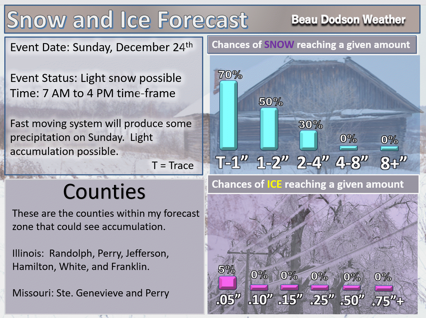
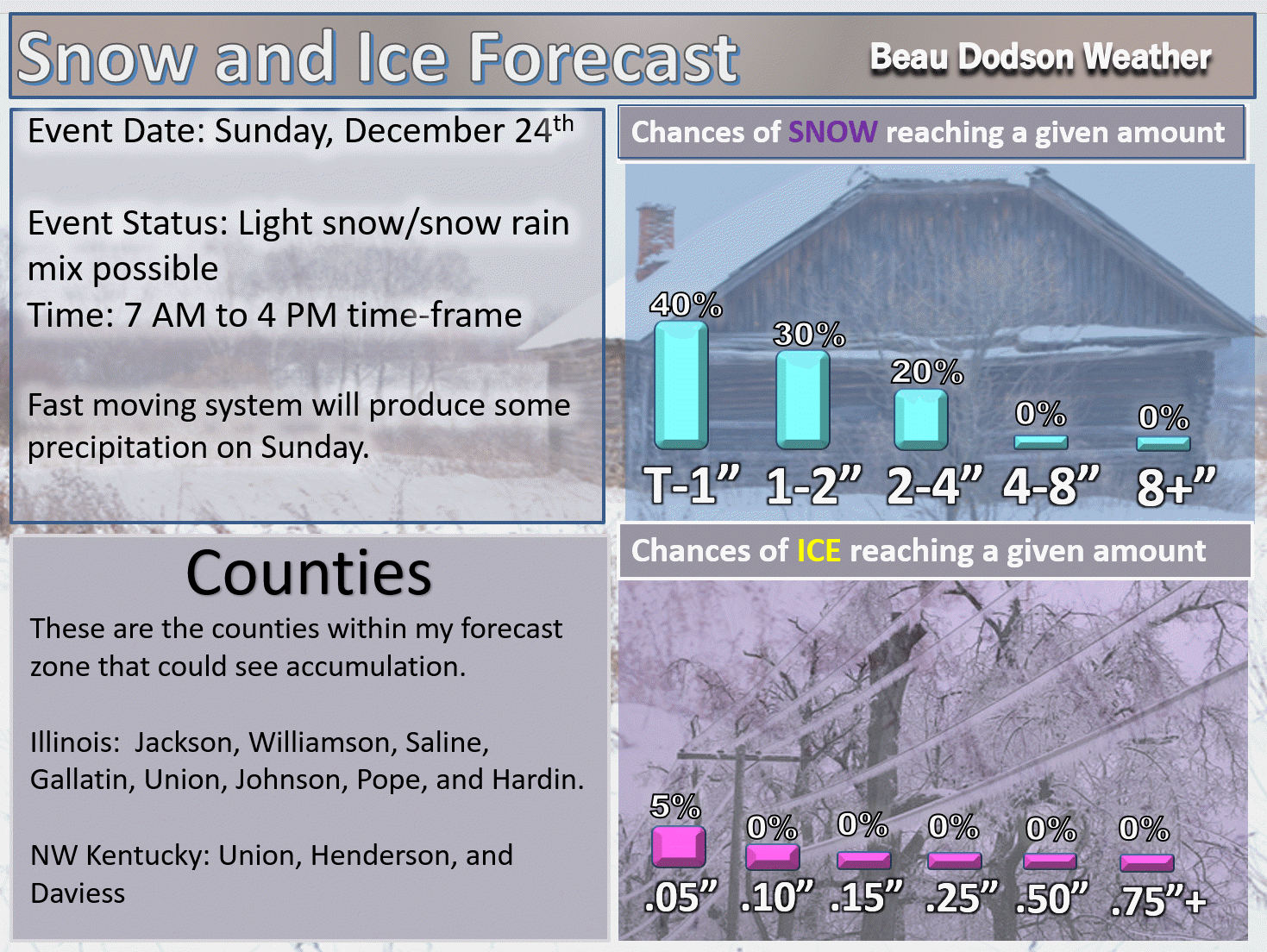
A light snow event is possible on Sunday (northern counties). Here are my latest forecast numbers.
Quick update. I will keep the blog updated (shorter entries) this weekend.
.
and
.
December 23, 2017
Saturday Forecast Details
Forecast: Mostly cloudy this morning. Snow or rain showers ending. It will be cold today and breezy.
Temperatures: MO ~ 36 to 42 IL ~ 36 to 42 KY ~ 38 to 44
What is the chance of precipitation? Ending
Coverage of precipitation: Decreasing coverage from west to east.
Wind chill values: 20’s and 30’s
Accumulating snow or ice: Whatever snow fell will likely melt this morning. Several of you had a dusting.
Winds: Northwest at 5 to 10 mph with gusts to 20 mph
What impacts are anticipated from the weather? Wet roadways.
My confidence in the forecast verifying: High
Is severe weather expected? No
The NWS defines severe weather as 58 mph wind or great, 1″ hail or larger, and/or tornadoes
Should I cancel my outdoor plans? Have a plan B
.
Saturday Night Forecast Details:
Forecast: Mostly cloudy. Colder. Flurries possible.
Temperatures: MO ~ 25 to 30 IL ~ 24 to 28 KY ~ 26 to 30
What is the chance of precipitation? MO ~ 10% IL ~ 10% KY ~ 10%
Coverage of precipitation: Small flurry chances.
Wind chill values: 18 to 26
Accumulating snow or ice: No
Winds: North and northeast at 5 to 10 mph
What impacts are anticipated from the weather? None
My confidence in the forecast verifying: High
Is severe weather expected? No
The NWS defines severe weather as 58 mph wind or great, 1″ hail or larger, and/or tornadoes
Should I cancel my outdoor plans: No
.
December 24, 2017
Sunday Forecast Details
Forecast: Quite a few clouds. Becoming breezy. A chance for light snow or snow/rain mix. Best chance of all snow would be northern counties of southeast Missouri and northern portions of southern Illinois. See graphics above.
Temperatures: MO ~ 34 to 38 IL ~ 34 to 38 KY ~ 35 to 40
What is the chance of precipitation? MO ~ 40% IL ~ 50% KY ~ 40%
Coverage of precipitation: Scattered to perhaps a period of widespread precipitation (esp northern counties of the area)
Wind chill values: Teens and 20’s
Accumulating snow or ice: A chance for an inch or less across northern portions of southeast Missouri and northern portions of southern Illinois (see graphics above for county forecast).
Winds: West and northwest at 10 to 20 mph with gusts above 20 mph possible
What impacts are anticipated from the weather? Small chance of snow sticking to bridges and roads over our far northern counties. Low confidence.
My confidence in the forecast verifying: Medium
Is severe weather expected? No
The NWS defines severe weather as 58 mph wind or great, 1″ hail or larger, and/or tornadoes
Should I cancel my outdoor plans? Monitor radars. It will be cold and there might be some light precipitation.
.
Sunday Night Forecast Details:
Forecast: Clearing overnight. Colder.
Temperatures: MO ~ 16 to 22 IL ~ 16 to 22 KY ~ 20 to 25
What is the chance of precipitation? MO ~ 0% IL ~ 10% KY ~ 10%
Coverage of precipitation: None
Wind chill values: 10 to 20
Accumulating snow or ice: No
Winds: West and northwest at 5 to 10 mph with gusts to 18 mph
What impacts are anticipated from the weather? Most likely none
My confidence in the forecast verifying: High
Is severe weather expected? No
The NWS defines severe weather as 58 mph wind or great, 1″ hail or larger, and/or tornadoes
Should I cancel my outdoor plans: No
.
December 25, 2017
Monday Forecast Details
Forecast: Partly to mostly sunny. Cold. Flurries possible.
Temperatures: MO ~ 34 to 38 IL ~ 32 to 38 KY ~ 35 to 40
What is the chance of precipitation? MO ~ 20% IL ~ 20% KY ~ 20%
Coverage of precipitation: None to isolated
Wind chill values: Upper teens to upper 20’s
Accumulating snow or ice: Unlikely
Winds: Variable at 5 to 10 mph
What impacts are anticipated from the weather? Most likely none
My confidence in the forecast verifying: High
Is severe weather expected? No
The NWS defines severe weather as 58 mph wind or great, 1″ hail or larger, and/or tornadoes
Should I cancel my outdoor plans? No
.
Monday Night Forecast Details:
Forecast: A period of clouds. Flurries possible.
Temperatures: MO ~ 22 to 26 IL ~ 22 to 26 KY ~ 22 to 26
What is the chance of precipitation? MO ~ 10% IL ~ 10% KY ~ 10%
Coverage of precipitation: None to isolated
Wind chill values: 15 to 20
Accumulating snow or ice: No
Winds: East and southeast at 4 to 8 mph
What impacts are anticipated from the weather? Most likely none
My confidence in the forecast verifying: High
Is severe weather expected? No
The NWS defines severe weather as 58 mph wind or great, 1″ hail or larger, and/or tornadoes
Should I cancel my outdoor plans: No
.
December 26, 2017
Tuesday Forecast Details
Forecast: Partly to mostly sunny. Cold. A few flurries possible.
Temperatures: MO ~ 35 to 40 IL ~ 34 to 38 KY ~ 35 to 40
What is the chance of precipitation? MO ~ 20% IL ~ 20% KY ~ 20%
Coverage of precipitation: None to isolated
Wind chill values: 20;s and 30’s
Accumulating snow or ice: No
Winds: North and northeast at 5 to 10 mph
What impacts are anticipated from the weather? Most likely none
My confidence in the forecast verifying: High
Is severe weather expected? No
The NWS defines severe weather as 58 mph wind or great, 1″ hail or larger, and/or tornadoes
Should I cancel my outdoor plans? No
.
Tuesday Night Forecast Details:
Forecast: Some clouds. A flurry possible.
Temperatures: MO ~ 14 to 18 IL ~ 14 to 18 KY ~ 15 to 20
What is the chance of precipitation? MO ~ 10% IL ~ 10% KY ~ 10%
Coverage of precipitation: None to isolated
Wind chill values: 8 to 16
Accumulating snow or ice: No
Winds: East at 4 to 8 mph
What impacts are anticipated from the weather? Cold wind chills
My confidence in the forecast verifying: High
Is severe weather expected? No
The NWS defines severe weather as 58 mph wind or great, 1″ hail or larger, and/or tornadoes
Should I cancel my outdoor plans: No
.
December 27, 2017
Wednesday Forecast Details
Forecast: Partly sunny. Cold. I will be monitoring precipitation chances.
Temperatures: MO ~ 28 to 34 IL ~ 28 to 34 KY ~ 32 to 36
What is the chance of precipitation? MO ~ 10% IL ~ 10% KY ~ 10%
Coverage of precipitation: Most likely none, but monitor
Wind chill values: 20’s and 30’s
Accumulating snow or ice: No
Winds: Variable at 5 to 10 mph
What impacts are anticipated from the weather? Most likely none
My confidence in the forecast verifying: Medium
Is severe weather expected? No
The NWS defines severe weather as 58 mph wind or great, 1″ hail or larger, and/or tornadoes
Should I cancel my outdoor plans? No
.
Wednesday Night Forecast Details:
Forecast: Increasing clouds.
Temperatures: MO ~ 16 to 22 IL ~ 16 to 22 KY ~ 16 to 22
What is the chance of precipitation? MO ~ 10% IL ~ 10% KY ~ 10%
Coverage of precipitation: Monitor updates
Wind chill values: 20’s and 30’s
Accumulating snow or ice: Monitor updates
Winds: Variable at 5 to 10 mph
What impacts are anticipated from the weather? Monitor updates
My confidence in the forecast verifying: LOW
Is severe weather expected? No
The NWS defines severe weather as 58 mph wind or great, 1″ hail or larger, and/or tornadoes
Should I cancel my outdoor plans: No
.
.
December 28, 2017
Thursday Forecast Details
Forecast: Cloudy. A chance for snow or rain/snow.
Temperatures: MO ~ 30 to 35 IL ~ 28 to 34 KY ~ 32 to 36
What is the chance of precipitation? MO ~ 30% IL ~ 30% KY ~ 30%
Coverage of precipitation: Monitor
Wind chill values: 20’s and 30’s
Accumulating snow or ice: Monitor
Winds: Northeast at 5 to 10 mph
What impacts are anticipated from the weather? Monitor
My confidence in the forecast verifying: LOW
Is severe weather expected? No
The NWS defines severe weather as 58 mph wind or great, 1″ hail or larger, and/or tornadoes
Should I cancel my outdoor plans? Monitor
.
Thursday Night Forecast Details:
Forecast: Cloudy. Snow possible. Low confidence.
Temperatures: MO ~ 16 to 22 IL ~ 16 to 22 KY ~ 16 to 22
What is the chance of precipitation? MO ~ 30% IL ~ 30% KY ~ 30%
Coverage of precipitation: Monitor updates
Wind chill values: 15 to 20
Accumulating snow or ice: Monitor updates
Winds: North at 6 to 12 mph
What impacts are anticipated from the weather? Monitor updates
My confidence in the forecast verifying: LOW
Is severe weather expected? No
The NWS defines severe weather as 58 mph wind or great, 1″ hail or larger, and/or tornadoes
Should I cancel my outdoor plans: Monitor


We offer regional radars and local city radars – if a radar does not update then try another one. Occasional browsers need their cache cleared. You may also try restarting your browser. This will usually fix any problems.
During the winter you can track snow and ice by clicking the winterize button on the local city view interactive radars.
You may email me at beaudodson@usawx.com
Interactive Weather Radar Page. Choose the city nearest your location: Click this link
National interactive radar: Click this link.