
.
Your daily forecast into the coming weekend.
Thursday Night Forecast Details:
Forecast: Increasing clouds. A chance of late night showers.
Temperatures: MO ~ 46 to 52 IL ~ 46 to 52 KY ~ 46 to 52
What is the chance of precipitation? MO ~ 40% IL ~ 40% KY ~ 40%
Coverage of precipitation: Scattered (late)
Wind chill values: 40’s
Accumulating snow or ice: No
Winds: South and southwest winds at 5 to 10 mph with gusts to 15 mph
What impacts are anticipated from the weather? Perhaps wet roadways late
My confidence in the forecast verifying: High
Is severe weather expected? No
The NWS defines severe weather as 58 mph wind or great, 1″ hail or larger, and/or tornadoes
Should I cancel my outdoor plans: No
.
December 22, 2017
Friday Forecast Details
Forecast: Mostly cloudy. Showers increasing through the day. Falling temperatures behind a cold front that will slowly push west to east. Temperatures will fall into the 40’s over portions of southeast Missouri and southern Illinois. High temperatures will be during the morning hours.
Temperatures: MO ~ 52 to 58 IL ~ 52 to 56 KY ~ 54 to 58
What is the chance of precipitation? MO ~ 60% IL ~ 60% KY ~ 70%
Coverage of precipitation: Scattered to perhaps widespread. Rain coverage will increase from the south and southwest as we move through the day.
Wind chill values: N/A
Accumulating snow or ice: No
Winds: South and southwest at 5 to 10 mph with gusts to 12. Winds becoming west and northwest behind the cold front.
What impacts are anticipated from the weather? Wet roadways.
My confidence in the forecast verifying: High
Is severe weather expected? No
The NWS defines severe weather as 58 mph wind or great, 1″ hail or larger, and/or tornadoes
Should I cancel my outdoor plans? Have a plan B
.
Friday Night Forecast Details:
Forecast: Rain likely. Locally heavy rain possible, especially over the Missouri Bootheel, west TN and west KY. Rain may mix with or change to a rain/snow mix or wet snow over southeast Missouri and southern Illinois. Perhaps western Kentucky, as well. Confidence remains low on the snow portion of the forecast. Turning colder.
Temperatures: MO ~ 32 to 36 IL ~ 32 to 38 KY ~ 34 to 40
What is the chance of precipitation? MO ~ 70% IL ~ 80% KY ~ 90%
Coverage of precipitation: Widespread
Wind chill values: 20 to 30
Accumulating snow or ice: Unlikely. A small risk over southeast Missouri and southern Illinois. It would be a rain/snow mix or wet snowflakes.
Winds: Becoming north and northwest at 5 to 10 mph with gusts to 14.
What impacts are anticipated from the weather? Wet roadways. Where the heaviest rain occurs you could have water over roadways. Low end flash flood risk.
My confidence in the forecast verifying: High
Is severe weather expected? Unlikely, but heavy rain is a possibility
The NWS defines severe weather as 58 mph wind or great, 1″ hail or larger, and/or tornadoes
Should I cancel my outdoor plans: Have a plan B
.
December 23, 2017
Saturday Forecast Details
Forecast: Mostly cloudy. Rain/snow mix or snow showers possible. Precipitation ending west to east. A burst of wet snow is possible over southeast Missouri and southern Illinois/northwest Kentucky.
Temperatures: MO ~ 36 to 42 IL ~ 36 to 42 KY ~ 38 to 44
What is the chance of precipitation? MO ~ 60% IL ~ 60% KY ~ 60%
Coverage of precipitation: Widespread during the morning. Decreasing coverage through the afternoon.
Wind chill values: 30’s
Accumulating snow or ice: Small chance of accumulating snow on grassy surfaces (SE MO int south IL and NW KY)
Winds: Northwest at 5 to 10 mph with gusts to 15 mph
What impacts are anticipated from the weather? Wet roadways.
My confidence in the forecast verifying: Medium
Is severe weather expected? No
The NWS defines severe weather as 58 mph wind or great, 1″ hail or larger, and/or tornadoes
Should I cancel my outdoor plans? Have a plan B
.
Saturday Night Forecast Details:
Forecast: Mostly cloudy. Colder. Flurries possible.
Temperatures: MO ~ 24 to 28 IL ~ 22 to 26 KY ~ 24 to 28
What is the chance of precipitation? MO ~ 10% IL ~ 20% KY ~ 10%
Coverage of precipitation: Most of the precipitation should have ended. Small flurry chances.
Wind chill values: 20 to 25
Accumulating snow or ice: No
Winds: North and northwest at 5 to 10 mph
What impacts are anticipated from the weather? None
My confidence in the forecast verifying: High
Is severe weather expected? No
The NWS defines severe weather as 58 mph wind or great, 1″ hail or larger, and/or tornadoes
Should I cancel my outdoor plans: No
.
December 24, 2017
Sunday Forecast Details
Forecast: Partly cloudy. Rain/snow or snow showers possible. Greatest chance will be over extreme northern portions of southeast Missouri and extreme northern portions of southern Illinois. Chances decrease rapidly as you move southward.
Temperatures: MO ~ 34 to 38 IL ~ 34 to 38 KY ~ 35 to 40
What is the chance of precipitation? MO ~ 20% IL ~ 40% KY ~ 20%
Coverage of precipitation: Low confidence for scattered rain/snow or snow showers.
Wind chill values: 20’s
Accumulating snow or ice: Odds are low.
Winds: North and northwest at 6 to 12 mph with gusts to 16 mph
What impacts are anticipated from the weather? Most likely none. Monitor updated forecasts.
My confidence in the forecast verifying: Medium
Is severe weather expected? No
The NWS defines severe weather as 58 mph wind or great, 1″ hail or larger, and/or tornadoes
Should I cancel my outdoor plans? No
.
Sunday Night Forecast Details:
Forecast: Mostly cloudy the first half of the night. Clearing overnight. Colder.
Temperatures: MO ~ 16 to 22 IL ~ 16 to 22 KY ~ 20 to 25
What is the chance of precipitation? MO ~ 10% IL ~ 10% KY ~ 10%
Coverage of precipitation: Most likely none
Wind chill values: 10 to 20
Accumulating snow or ice: Most likely no
Winds: West and northwest at 5 to 10 mph
What impacts are anticipated from the weather? Most likely none
My confidence in the forecast verifying: Medium
Is severe weather expected? No
The NWS defines severe weather as 58 mph wind or great, 1″ hail or larger, and/or tornadoes
Should I cancel my outdoor plans: No
.
December 25, 2017
Monday Forecast Details
Forecast: Partly to mostly sunny. Cold. Flurries possible.
Temperatures: MO ~ 35 to 40 IL ~ 32 to 38 KY ~ 35 to 40
What is the chance of precipitation? MO ~ 20% IL ~ 20% KY ~ 20%
Coverage of precipitation: Most likely none to isolated
Wind chill values: Upper teens to upper 20’s
Accumulating snow or ice: Unlikely
Winds: Variable at 5 to 10 mph
What impacts are anticipated from the weather? Most likely none
My confidence in the forecast verifying: High
Is severe weather expected? No
The NWS defines severe weather as 58 mph wind or great, 1″ hail or larger, and/or tornadoes
Should I cancel my outdoor plans? It will be cold
.
Monday Night Forecast Details:
Forecast: A period of clouds. Flurries possible.
Temperatures: MO ~ 22 to 26 IL ~ 22 to 26 KY ~ 22 to 26
What is the chance of precipitation? MO ~ 10% IL ~ 10% KY ~ 10%
Coverage of precipitation: None to isolated
Wind chill values: 15 to 20
Accumulating snow or ice: No
Winds: East and southeast at 4 to 8 mph
What impacts are anticipated from the weather? Most likely none
My confidence in the forecast verifying: High
Is severe weather expected? No
The NWS defines severe weather as 58 mph wind or great, 1″ hail or larger, and/or tornadoes
Should I cancel my outdoor plans: It will be quite cold
.
December 26, 2017
Tuesday Forecast Details
Forecast: Partly to mostly sunny. Cold.
Temperatures: MO ~ 35 to 40 IL ~ 34 to 38 KY ~ 35 to 40
What is the chance of precipitation? MO ~ 0% IL ~ 0% KY ~ 0%
Coverage of precipitation: None
Wind chill values: 20;s and 30’s
Accumulating snow or ice: No
Winds: Variable at 5 to 10 mph
What impacts are anticipated from the weather? Most likely none
My confidence in the forecast verifying: High
Is severe weather expected? No
The NWS defines severe weather as 58 mph wind or great, 1″ hail or larger, and/or tornadoes
Should I cancel my outdoor plans? No
.
Tuesday Night Forecast Details:
Forecast: Partly cloudy and cold.
Temperatures: MO ~ 20 to 25 IL ~ 20 to 25 KY ~ 20 to 25
What is the chance of precipitation? MO ~ 0% IL ~ 0% KY ~ 0%
Coverage of precipitation: None anticipated
Wind chill values: 20’s and 30’s
Accumulating snow or ice: No
Winds: East at 4 to 8 mph
What impacts are anticipated from the weather? None anticipated
My confidence in the forecast verifying: High
Is severe weather expected? No
The NWS defines severe weather as 58 mph wind or great, 1″ hail or larger, and/or tornadoes
Should I cancel my outdoor plans: No
.
December 27, 2017
Wednesday Forecast Details
Forecast: Partly sunny. Cold. I will be monitoring precipitation chances.
Temperatures: MO ~ 35 to 40 IL ~ 32 to 36 KY ~ 34 to 38
What is the chance of precipitation? MO ~ 10% IL ~ 10% KY ~ 10%
Coverage of precipitation: Most likely none, but monitor
Wind chill values: 20’s and 30’s
Accumulating snow or ice: No
Winds: Variable at 5 to 10 mph
What impacts are anticipated from the weather? Most likely none
My confidence in the forecast verifying: LOW
Is severe weather expected? No
The NWS defines severe weather as 58 mph wind or great, 1″ hail or larger, and/or tornadoes
Should I cancel my outdoor plans? No
.
Wednesday Night Forecast Details:
Forecast: Partly cloudy. I will be monitoring precipitation chances.
Temperatures: MO ~ 24 to 28 IL ~ 24 to 28 KY ~ 24 to 28
What is the chance of precipitation? MO ~ 10% IL ~ 10% KY ~ 10%
Coverage of precipitation: Monitor updates
Wind chill values: 20’s and 30’s
Accumulating snow or ice: Monitor updates
Winds: Variable at 5 to 10 mph
What impacts are anticipated from the weather? Monitor updates
My confidence in the forecast verifying: LOW
Is severe weather expected? No
The NWS defines severe weather as 58 mph wind or great, 1″ hail or larger, and/or tornadoes
Should I cancel my outdoor plans: No
.

.
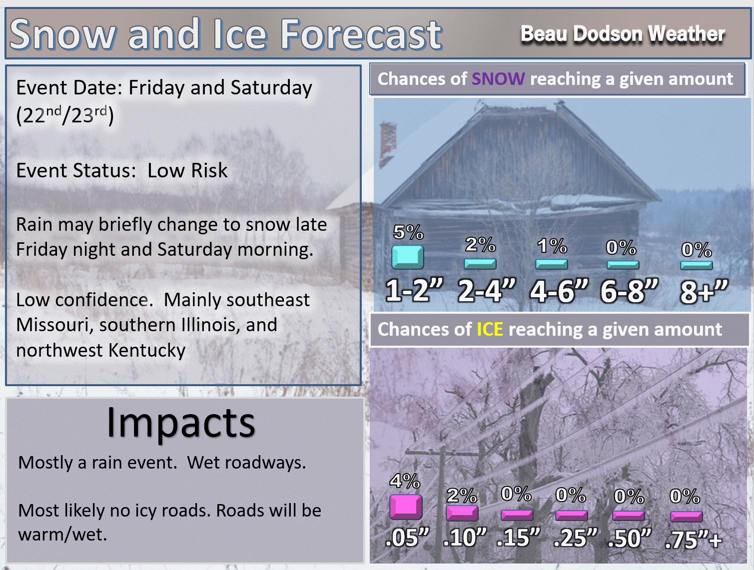
Friday night and Saturday morning: High confidence. Accumulating snow or ice is unlikely.
There will be a chance of a rain/snow mix or snow showers late Friday night and Saturday morning. This would mainly be over southeast Missouri and southern Illinois. Perhaps northwest Kentucky. Lesser chances elsewhere.
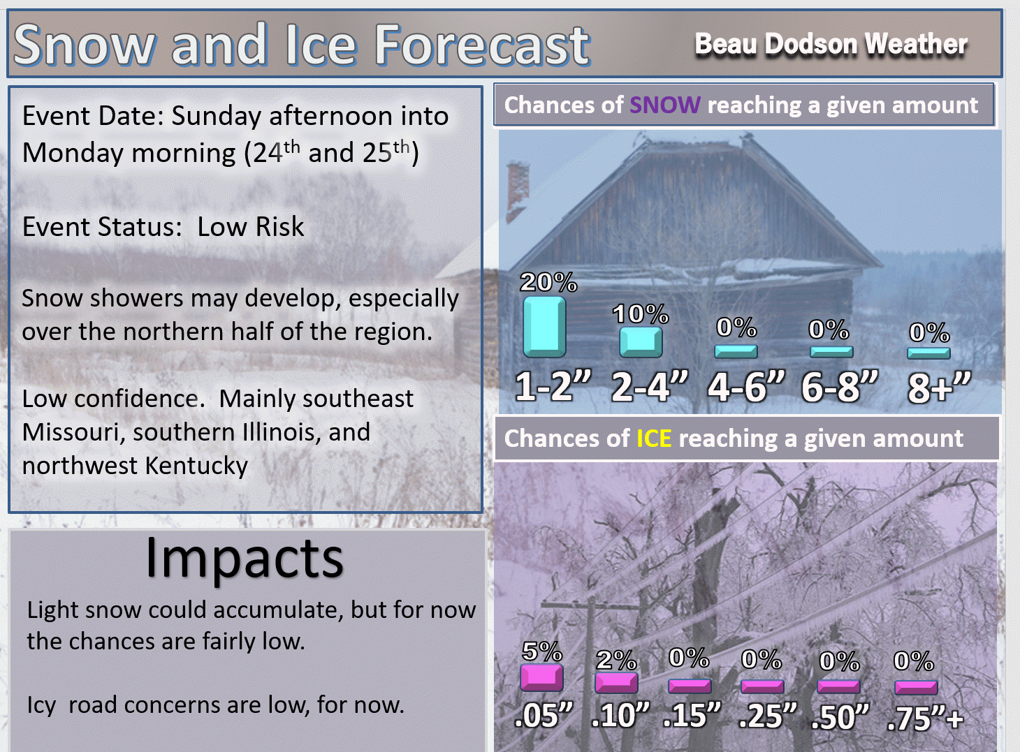
Sunday into Monday: Medium confidence. A fast moving system could produce a few snow showers on Sunday and Sunday night. The greatest chance would be over northern parts of southeast Missouri, northern parts of southern Illinois, and northwest Kentucky. Accumulation is unlikely.
Wednesday through Friday of next week: Some wintry weather is possible, but confidence is low.
.

.
The National Weather Service definition of a severe thunderstorm is one that produces quarter size hail or larger, 58 mph winds or greater, and/or a tornado.
Thursday night through next Thursday: High confidence. Severe weather is unlikely.
Friday and Friday night: Locally heavy rain is possible. The greatest concern for heavy rain will be across the Missouri Bootheel into western Kentucky and northwest Tennessee.
.

.
Forecast
Interactive Weather Radar Page. Choose the city nearest your location: Click this link
Changeable forecasts are likely over the coming two weeks. Confidence in the forecast guidance is medium.
Interactive Weather Radar Page. Choose the city nearest your location: Click this link
Friday into Saturday
A rain maker will impact the region Friday into Saturday.
Widespread rain is anticipated with this event. Heavy rain is possible, especially over Kentucky and Tennessee.
There is a low end risk for flash flooding. The WPC/NOAA has outlined a region for excessive rainfall. Excessive rainfall means rain that could cause some flooding of roads/other areas.
They have a four level scale. One being the lowest risk. Four being the highest risk.
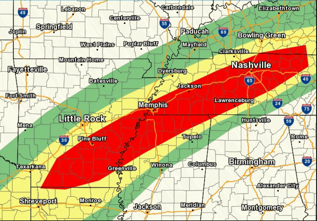
Here is their graphic for Friday night and Saturday morning.
Red is the level three risk zone (highest risk on this map)
Yellow is the level two risk zone
Green is the level one risk zone (lowest)
.
.
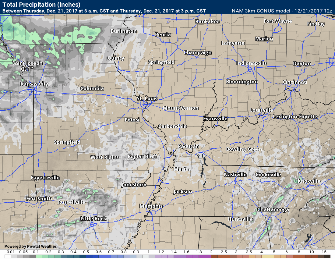
Here is the NAM model future-cast radar returns. Time stamp upper left.
This graphic shows you rain and snow on radar. It is a forecast of what radar should look like moving forward. Green is rain. Yellow is heavier rain. Blue would be snow.
.

.
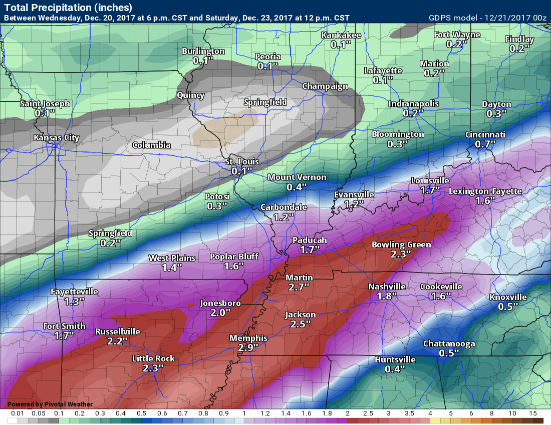
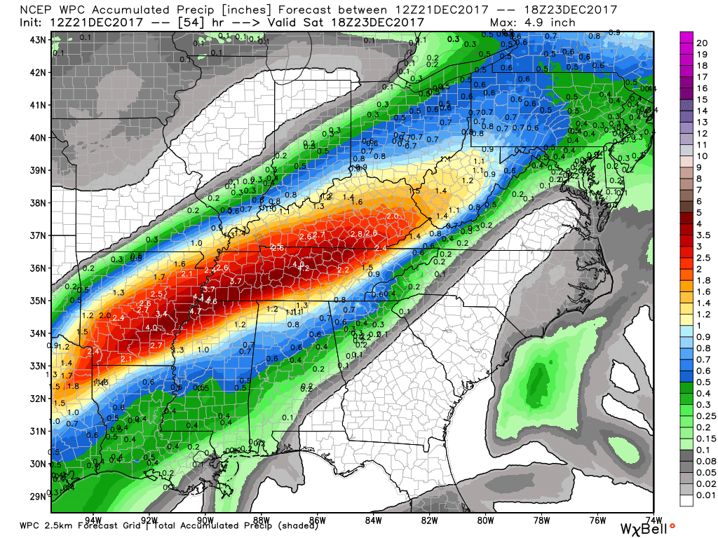
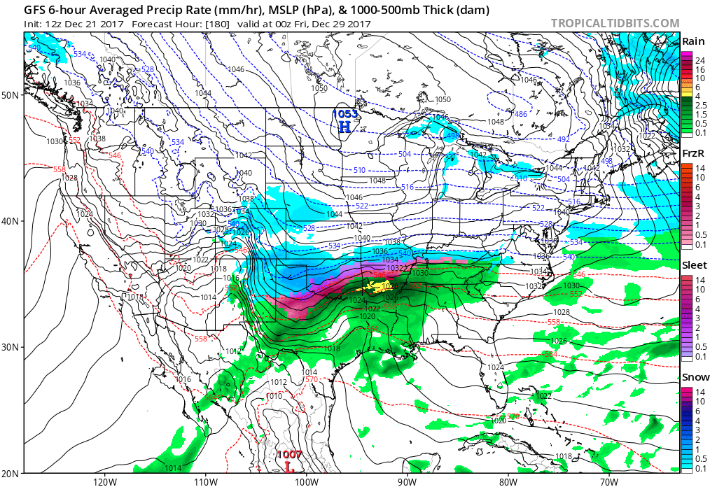
Here is the NAM model future-cast rain totals. Remember, this is a model. Models are for guidance and are not gospel.
Rain totals will vary, as always.
.
.
Couple more model packages. We desperately need this rain.
This is the GEM model rainfall forecast.
.
.
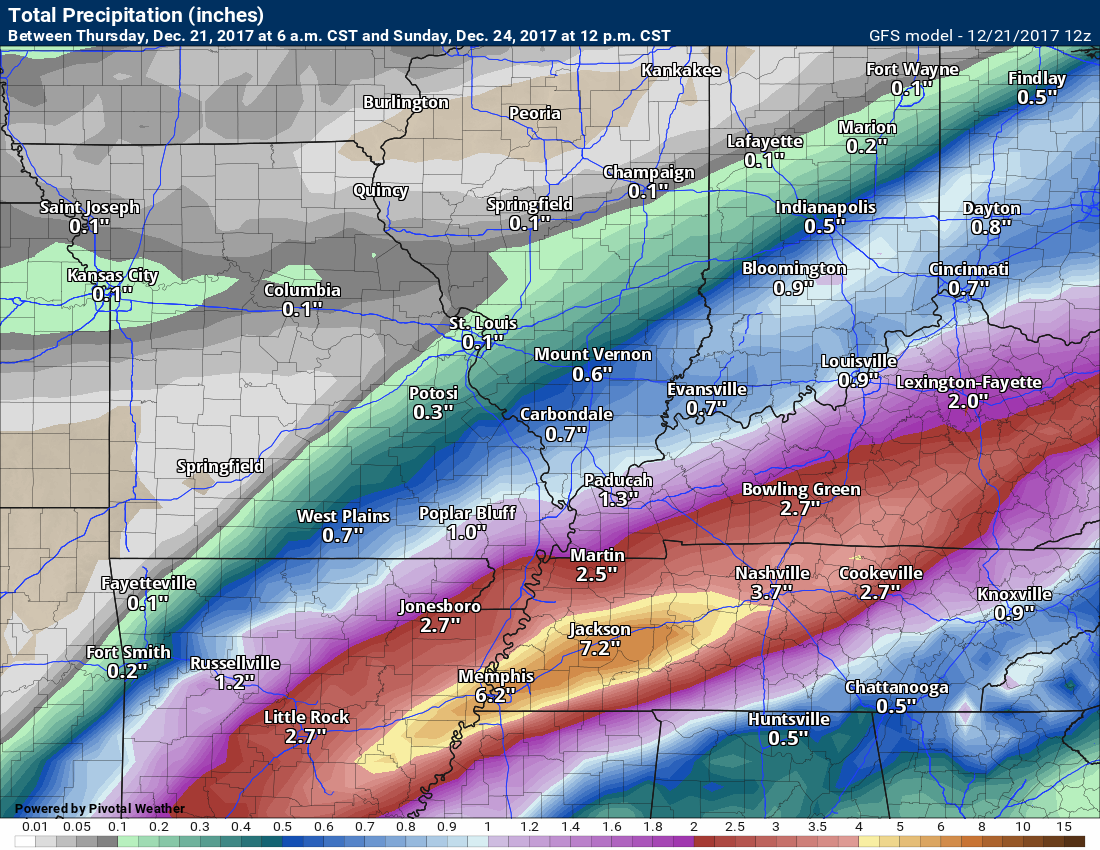
This is the GFS model rainfall forecast.
.
.
Here is the NOAA rainfall forecast. Click to enlarge.
.
.
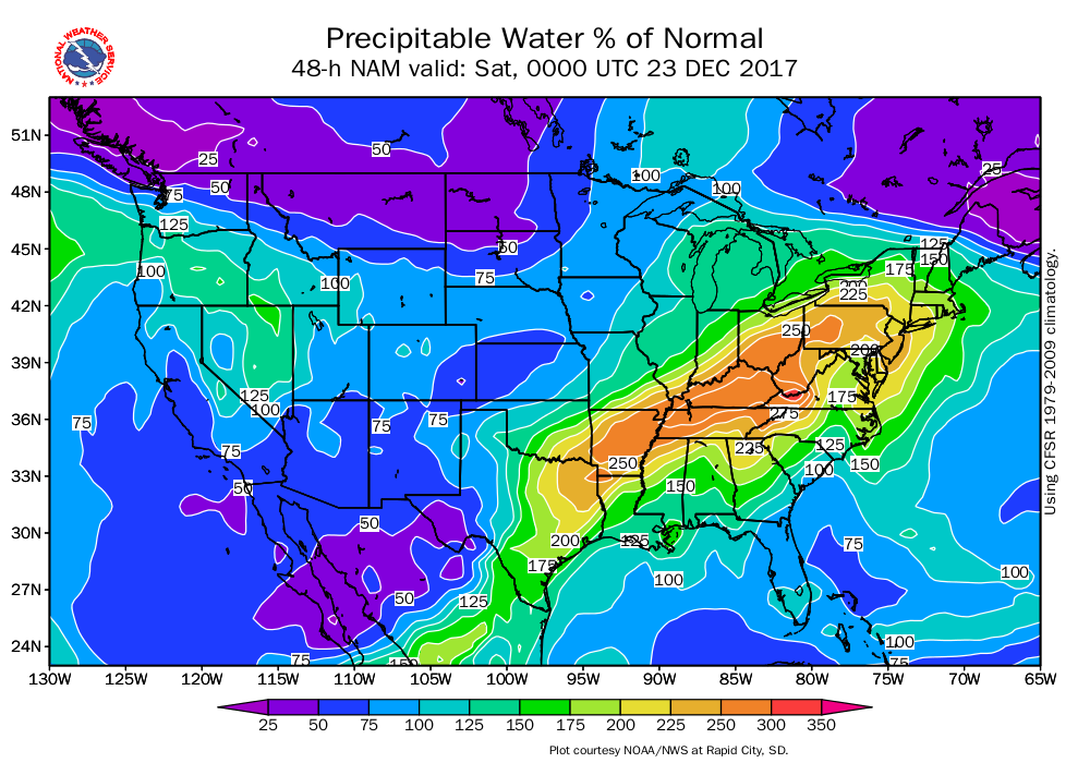
PWAT values are going to be very high. 150% to 200%+ above normal. PWAT is a measure of moisture in the entire atmosphere.
.
.
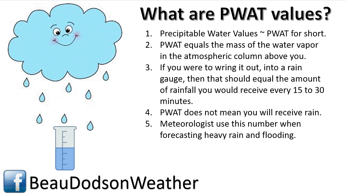
What are PWAT values?
.
.
.
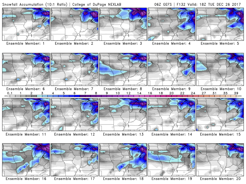
Here are the GFS snow ensembles
Click to enlarge the images on this page. The colors represent snow totals.
This first set of ensembles is through Christmas Day. You can see hints of snow, but not much. Ensembles show better odds for accumulating snow over Indiana and then and east of there.
There are hints of snow in our area. We will see how Sunday trends. That is the best chance of precipitation.
Most of them do have a smattering of light grey in our local area. That represents a dusting to an inch of snow. This would mainly be over Missouri and Illinois.
.
.
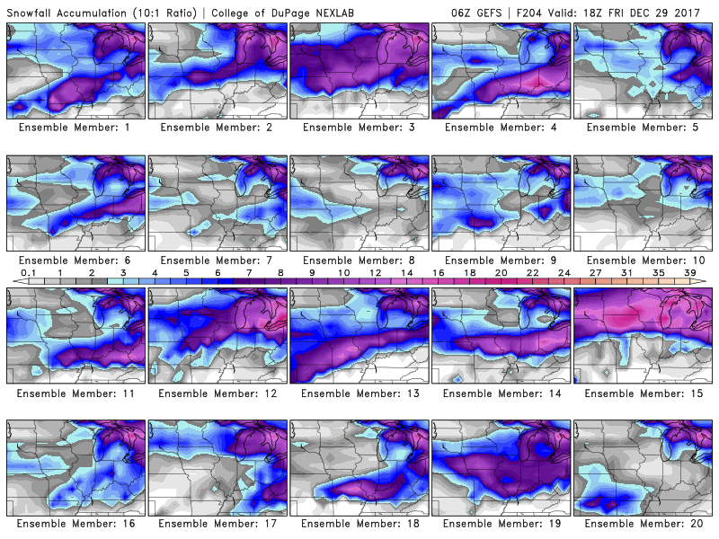
Pulling further out, you can see chances of snow through next week. Several of the ensemble members give decent chances for a winter storm. Too early for certainties.
The pattern remains favorable for winter storms.
Ignore the actual amounts. Just focus on the idea that there could be snow in our region over the next 7 to 14 days.
It is luck of the draw on each systems track.
.
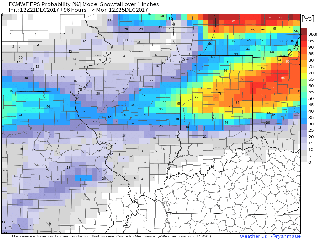
Christmas Eve and Christmas Day
This map pretty much sums up my thinking on the white Christmas chances. It remains a long shot. Not a zero chance, but a low chance for southeast Missouri and southern Illinois/northwest Kentucky.
This is the % chance of 1″ or more of snow. This is from the EC guidance.
Notice the odds increase as you travel north.
.
.
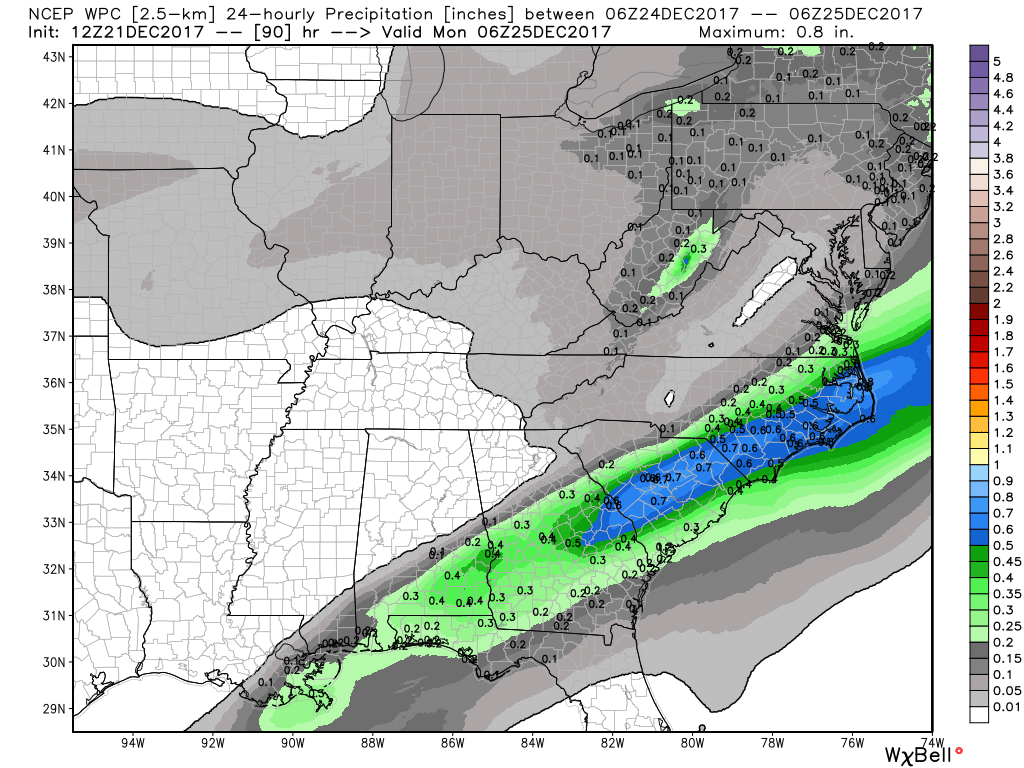
I am tracking a system for Sunday and Sunday night. The system could spread a rain/snow mix or snow into some of our local counties. The best chance would be over northern portions of southeast Missouri, northern half of southern Illinois, and northwest Kentucky. Even there, it is a bit of a long shot.
Accumulation chances are low.
Here is the official WPC/NOAA precipitation forecast for the Sunday event.
Light grey colors. Light precipitation.
Taken at face value, these colors represent less than 0.10″ of precipitation. That would mean one inch or less of snow.
.
.
It will be colder starting Saturday and lasting into next week. Below normal temperatures are anticipated. Normal high temperatures are in the middle 40’s and normal low temperatures are in the upper 20’s.
We will be several degrees below those numbers.
Tuesday through Friday of next week
I am tracking a system towards the middle of next week. This could bring wintry precipitation into our region. There remain questions on the eventual track and intensity of the system.
If the track is too far north then we will have mostly rain.
Here are what some of the early model runs are showing.
GFS model guidance
This is for Wednesday night and Thursday. You can see some precipitation in our area. The GFS has a wintry mix.
Blue is snow. Pink is sleet. Green would be rain.
.
.
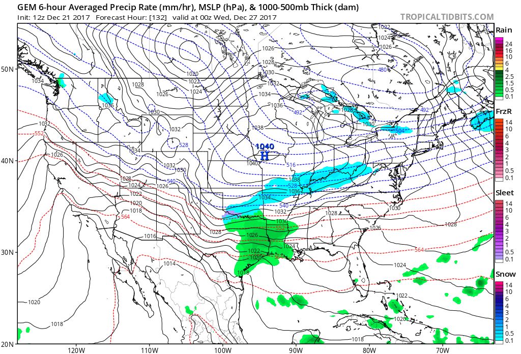
GEM/Canadian model guidance
This is for Wednesday evening. The GEM model guidance has some snow in our area.
Way too soon to know specifics. At this point, it is something I am watching.
.
.
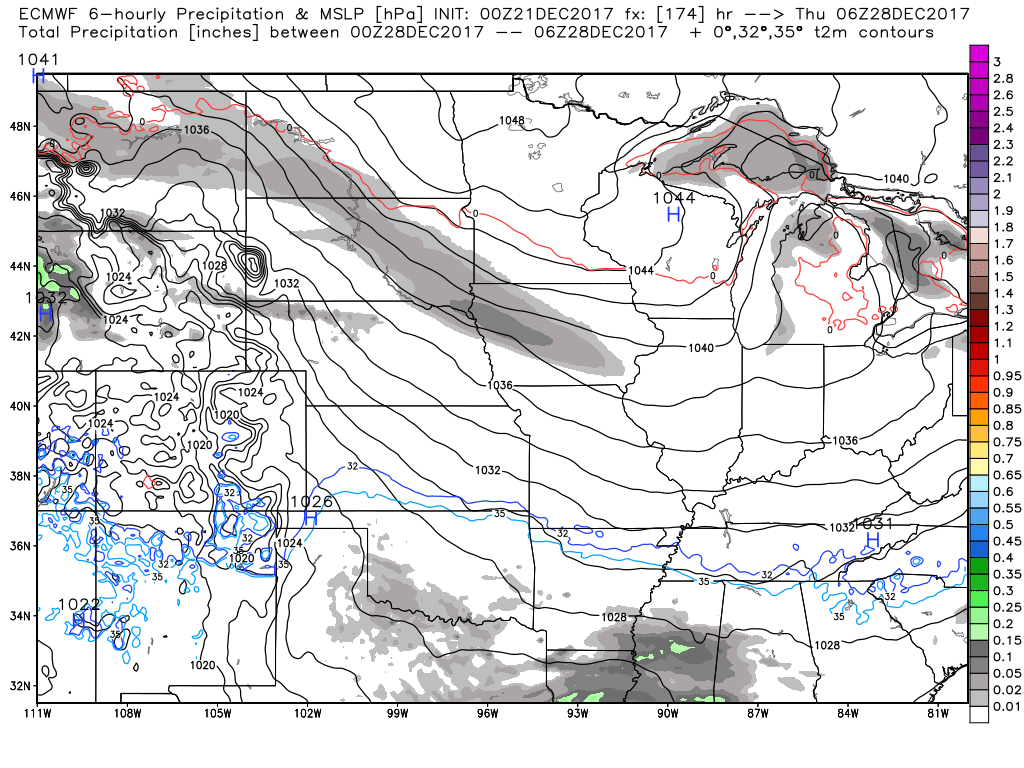
European/EC model guidance
The EC is the driest of these three model packages. It does show some potential for precipitation in the region, but not as defined as the other two guidance packages.
I believe the pattern favors more moisture than the EC is showing.
.
 .
.
.
This system will need to be monitored.
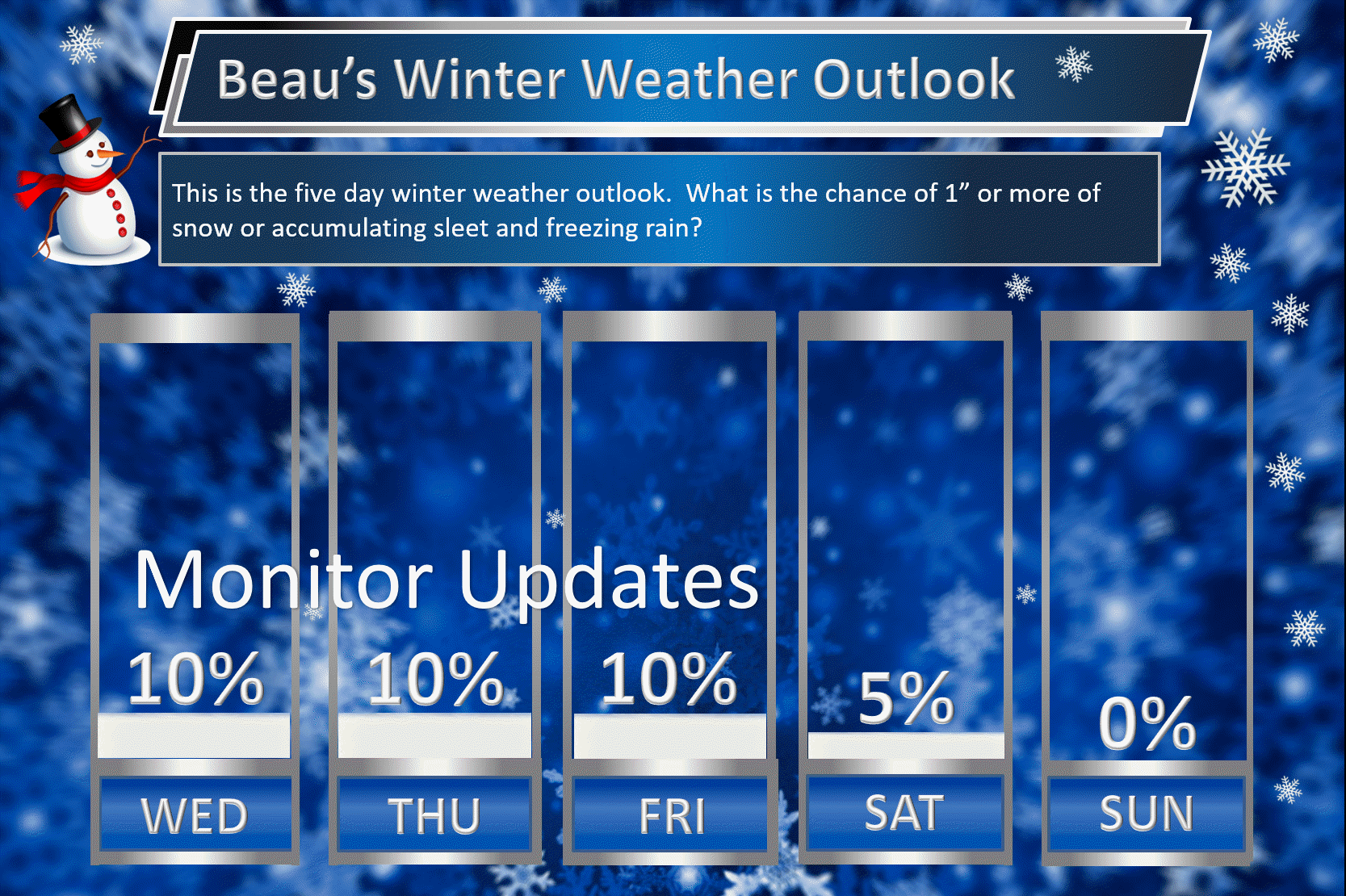
Beau’s Winter Weather Outlook
It is important to remember that this pattern is fluid. There is always going to be lower than normal confidence, during the winter months, for the forecast past day three or four.
.
.
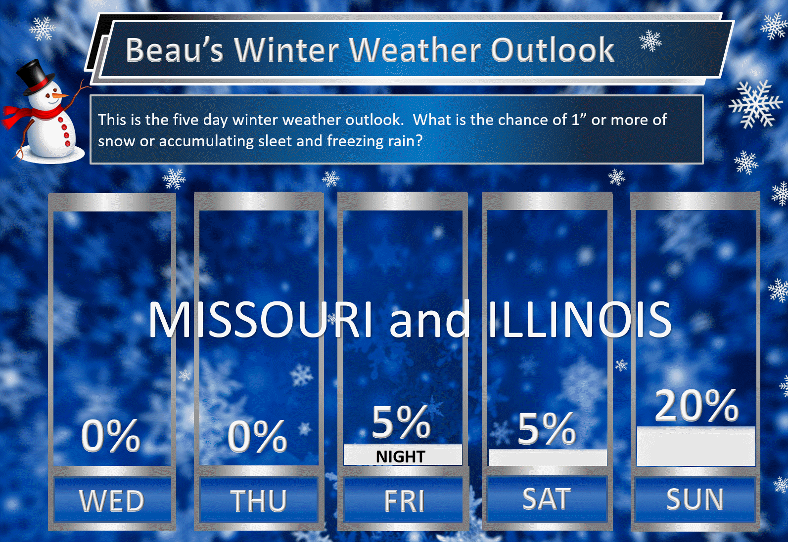
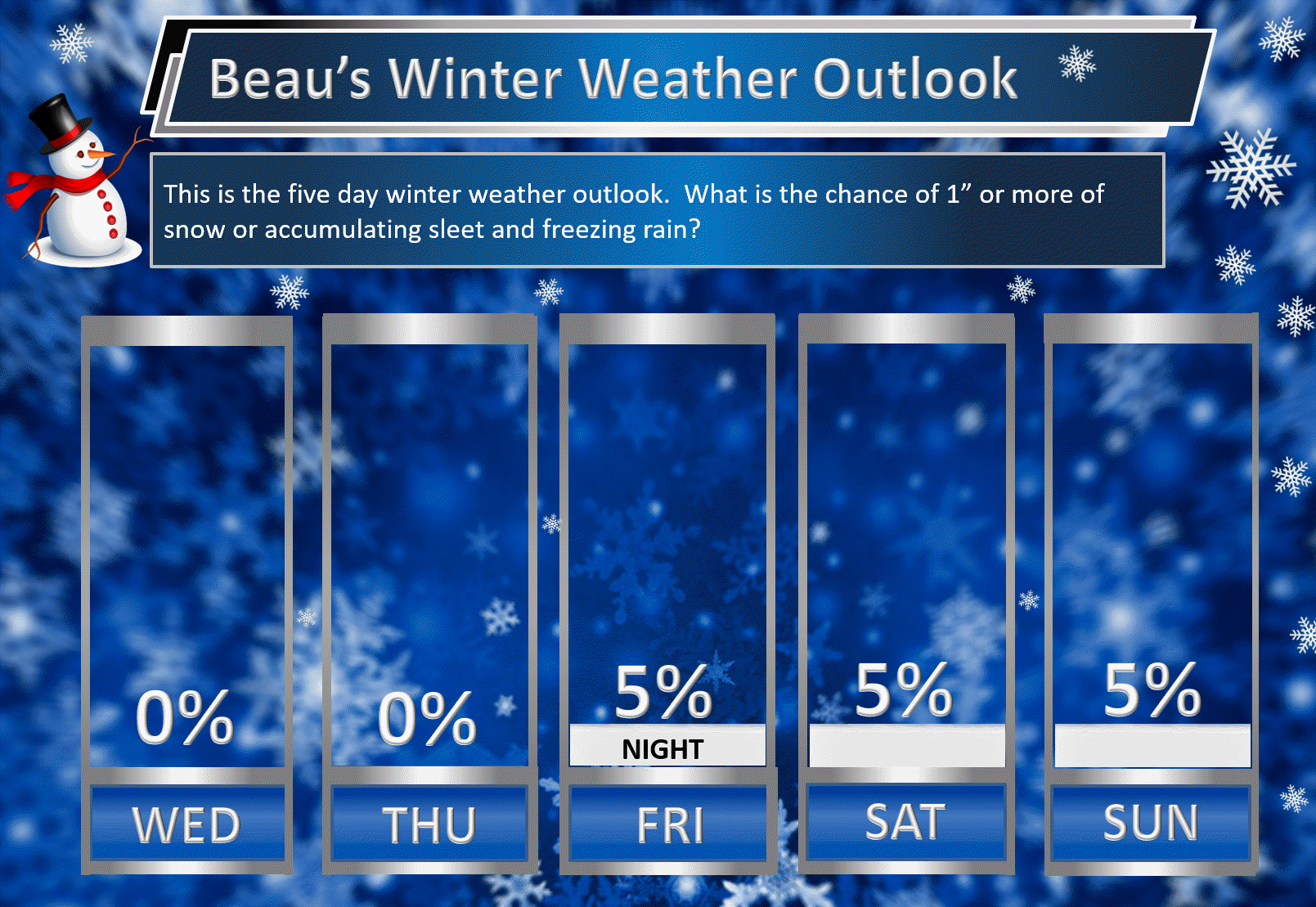
Here are my latest snow probability maps for the week ahead.
Breaking it down between snow and ice.
.
.
These have been updated with the latest data.
These graphics show you the % chance of one inch or more of snow and/or accumulating sleet and freezing rain.
I do not anticipate winter weather through Friday evening. I am monitoring Friday night and Saturday for a late night change to rain/snow mix of snow. This would occur as the rain system is pulling away. Accumulation appears unlikely.
Here is the Missouri and Illinois forecast
.
.
Here is the Kentucky and Tennessee forecast
.
.
Christmas week. Model guidance shows an active pattern that could mean multiple precipitation events. Monitor updates moving forward. Confidence is low (it is in the long range).
Keep in mind, I rarely go above 10% chances past day five. That means 10% is a max number for days six through ten.
Let’s keep an eye on the middle/end of next week for another system. Whether we end up on the warm side of that system is questionable. Odds favor at least some wintry precipitation.
This graphic is for the entire area.
.
.
The pattern remains favorable for wintry weather. The question is going to be storm track and the placement of a boundary in or near our region.
.


We offer regional radars and local city radars – if a radar does not update then try another one. Occasional browsers need their cache cleared. You may also try restarting your browser. This will usually fix any problems.
During the winter you can track snow and ice by clicking the winterize button on the local city view interactive radars.
You may email me at beaudodson@usawx.com
Interactive Weather Radar Page. Choose the city nearest your location: Click this link
National interactive radar: Click this link.