
.
Your daily forecast into the coming weekend.
Tuesday Night Forecast Details:
Forecast: Cloudy with dense fog possible. Scattered light showers over at least the southern half of the region. Mostly cloudy for our northern counties with small rain chances.
Temperatures: MO ~ 40 to 45 IL ~ 38 to 44 KY ~ 43 to 46
Wind chill values: 30’s and 40’s
Accumulating snow or ice: No
Winds: North and northeast winds at 5 to 10 mph
What impacts are anticipated from the weather? Wet roadways
My confidence in the forecast verifying: High
Is severe weather expected? No
The NWS defines severe weather as 58 mph wind or great, 1″ hail or larger, and/or tornadoes
What is the chance of precipitation? MO ~ 60% south a 20% north IL ~ 30% south and 10% north KY ~ 60% along the KY/TN border and 20% near the KY/IN border
Coverage of precipitation: Scattered
Should I cancel my outdoor plans: Monitor radars
.
December 20, 2017
Wednesday Forecast Details
Forecast: Mostly cloudy with showers possible, especially before 10 am. The northern half of the region may remain dry. The Bootheel into the KY/TN border area will stand the best chance of a light shower.
Temperatures: MO ~ 46 to 54 IL ~ 46 to 54 KY ~ 46 to 54
Wind chill values: N/A
Accumulating snow or ice: No
Winds: Northeast 5 to 10 mph with gusts to 12 mph
What impacts are anticipated from the weather? Wet roadways
My confidence in the forecast verifying: High
Is severe weather expected? No
The NWS defines severe weather as 58 mph wind or great, 1″ hail or larger, and/or tornadoes
What is the chance of precipitation? MO ~ 50% south and 20% north IL ~ 30% south and 10% north KY ~ 50% near KY/TN border and 20% near the KY/IN border
Coverage of precipitation: Scattered
Should I cancel my outdoor plans? Monitor radars
.
December 20, 2017
Wednesday Forecast Details
Forecast: Mostly cloudy with showers possible. Greater coverage over our southern counties (Bootheel into the KY/TN border area). Becoming partly cloudy during the afternoon.
Temperatures: MO ~ 46 to 54 IL ~ 46 to 54 KY ~ 46 to 54
Wind chill values: N/A
Accumulating snow or ice: No
Winds: Northeast 5 to 10 mph with gusts to 12 mph
What impacts are anticipated from the weather? Wet roadways
My confidence in the forecast verifying: High
Is severe weather expected? No
The NWS defines severe weather as 58 mph wind or great, 1″ hail or larger, and/or tornadoes
What is the chance of precipitation? MO ~ 60% IL ~ 60% KY ~ 80%
Coverage of precipitation: Scattered to widespread. Widespread would be our southern counties (as mentioned above).
Should I cancel my outdoor plans? Monitor radars
.
Wednesday Night Forecast Details:
Forecast: Clearing. Colder. Patchy fog possible.
Temperatures: MO ~ 30 to 35 IL ~ 30 to 35 KY ~ 30 to 35
Wind chill values: 25 to 35
Accumulating snow or ice: No
Winds: North and northeast winds at 4 to 8 mph
What impacts are anticipated from the weather? Patchy fog
My confidence in the forecast verifying: High
Is severe weather expected? No
The NWS defines severe weather as 58 mph wind or great, 1″ hail or larger, and/or tornadoes
What is the chance of precipitation? MO ~ 0% IL ~ 0% KY ~ 0%
Coverage of precipitation: None
Should I cancel my outdoor plans: No
.
December 21, 2017
Thursday Forecast Details
Forecast: Mostly sunny with a few passing clouds. Warmer
Temperatures: MO ~ 54 to 58 IL ~ 54 to 58 KY ~ 54 to 58
Wind chill values: N/A
Accumulating snow or ice: No
Winds: South winds at 5 to 10 mph
What impacts are anticipated from the weather? None
My confidence in the forecast verifying: High
Is severe weather expected? No
The NWS defines severe weather as 58 mph wind or great, 1″ hail or larger, and/or tornadoes
What is the chance of precipitation? MO ~ 0% IL ~ 0% KY ~ 0%
Coverage of precipitation: None
Should I cancel my outdoor plans? No
.
Thursday Night Forecast Details:
Forecast: Increasing clouds. A chance of late night showers.
Temperatures: MO ~ 45 to 50 IL ~ 45 to 50 KY ~ 45 to 50
Wind chill values: 40’s
Accumulating snow or ice: No
Winds: South and southwest winds at 5 to 10 mph
What impacts are anticipated from the weather? Perhaps wet roadways
My confidence in the forecast verifying: High
Is severe weather expected? No
The NWS defines severe weather as 58 mph wind or great, 1″ hail or larger, and/or tornadoes
What is the chance of precipitation? MO ~ 30% IL ~ 30% KY ~ 20%
Coverage of precipitation: Scattered
Should I cancel my outdoor plans: No
.
December 22, 2017
Friday Forecast Details
Forecast: Mostly cloudy. Showers likely. Low confidence.
Temperatures: MO ~50 to 55 IL ~ 50 to 55 KY ~ 54 to 58
Wind chill values: N/A
Accumulating snow or ice: Monitor updates
Winds: South and southwest at 8 to 16 mph and gusty
What impacts are anticipated from the weather? Wet roadways.
My confidence in the forecast verifying: LOW
Is severe weather expected? No
The NWS defines severe weather as 58 mph wind or great, 1″ hail or larger, and/or tornadoes
What is the chance of precipitation? MO ~ 40% IL ~ 50% KY ~ 50%
Coverage of precipitation: Scattered
Should I cancel my outdoor plans? Monitor updates
Friday Night Forecast Details:
Forecast: Mostly cloudy. Showers possible. Rain may mix with or change to snow. Turning colder late. Breezy.
Temperatures: MO ~ 28 to 34 IL ~ 30 to 34 KY ~ 30 to 35
Wind chill values: 20 to 30
Accumulating snow or ice: Monitor updates
Winds: Southwest winds becoming west and northwest at 7 to 14 mph. Gusty winds possible.
What impacts are anticipated from the weather? Wet roadways. I will monitor the snow potential.
My confidence in the forecast verifying: LOW
Is severe weather expected? Monitor updates
The NWS defines severe weather as 58 mph wind or great, 1″ hail or larger, and/or tornadoes
What is the chance of precipitation? MO ~ 40% IL ~ 60% KY ~ -60%
Coverage of precipitation: Scattered to perhaps widespread
Should I cancel my outdoor plans: Have a plan B
.
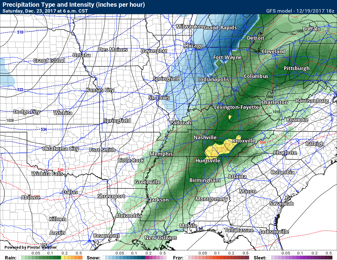
December 23, 2017
Saturday Forecast Details
Forecast: Clouds early. Snow possible.
Temperatures: MO ~ 36 to 42 IL ~ 36 to 42 KY ~ 40 to 45
Wind chill values: 30’s
Accumulating snow or ice: Monitor updates
Winds: Northwest at 10 to 20 mph
What impacts are anticipated from the weather? Monitor updates
My confidence in the forecast verifying: LOW
Is severe weather expected? No
The NWS defines severe weather as 58 mph wind or great, 1″ hail or larger, and/or tornadoes
What is the chance of precipitation? MO ~ 40% IL ~ 50% KY ~ 50%
Coverage of precipitation: Scattered
Should I cancel my outdoor plans? Monitor updates
.
Saturday Night Forecast Details:
Forecast: Mostly cloudy. Colder. Snow showers or flurries possible. Temperatures will be colder if we have snow on the ground.
Temperatures: MO ~ 24 to 28 IL ~ 24 to 28 KY ~ 24 to 28
Wind chill values: 20 to 25
Accumulating snow or ice: No
Winds: North and northwest at 5 to 10 mph
What impacts are anticipated from the weather? None
My confidence in the forecast verifying: Medium
Is severe weather expected? No
The NWS defines severe weather as 58 mph wind or great, 1″ hail or larger, and/or tornadoes
What is the chance of precipitation? MO ~ 20% IL ~ 20% KY ~ 20%
Coverage of precipitation:
Should I cancel my outdoor plans: No
.
December 24, 2017
Sunday Forecast Details
Forecast: Some clouds. Snow showers possible.
Temperatures: MO ~ 35 to 40 IL ~ 35 to 40 KY ~ 35 to 40
Wind chill values: 30’s
Accumulating snow or ice: Monitor updates
Winds: Northwest at 6 to 12 mph
What impacts are anticipated from the weather? Most likely none, but monitor updates
My confidence in the forecast verifying: LOW
Is severe weather expected? No
The NWS defines severe weather as 58 mph wind or great, 1″ hail or larger, and/or tornadoes
What is the chance of precipitation? MO ~ 30% IL ~ 30% KY ~ 30%
Coverage of precipitation: Scattered
Should I cancel my outdoor plans? Monitor updates
.
Sunday Night Forecast Details:
Forecast: Mostly cloudy. Cold. Snow showers possible.
Temperatures: MO ~ 20 to 25 IL ~ 20 to 25 KY ~ 20 to 25
Wind chill values: 15 to 25
Accumulating snow or ice: Monitor updates
Winds: West and northwest at 5 to 10 mph
What impacts are anticipated from the weather?
My confidence in the forecast verifying: LOW
Is severe weather expected? No
The NWS defines severe weather as 58 mph wind or great, 1″ hail or larger, and/or tornadoes
What is the chance of precipitation? MO ~ 30% IL ~ 40% KY ~ 30%
Coverage of precipitation: Scattered, but monitor updates
Should I cancel my outdoor plans: Monitor updates
Christmas Day: Cloudy with a chance of snow showers. High temperatures 30 to 35. Low confidence.
.

.
Tuesday night through Thursday: High confidence. The risk for freezing rain, sleet, and snow is near zero.
Friday through Tuesday: Low confidence. Wintry precipitation can’t be ruled out Friday night and Saturday morning. At this time, the chance of accumulation appears small. Monitor updates.
A winter storm may develop Sunday into Christmas Day. Low confidence. This system is forecast to deliver a wintry mix. The track of the system is unclear. Monitor updates. I can’t rule out our region being impacted by this system.
.

.
The National Weather Service definition of a severe thunderstorm is one that produces quarter size hail or larger, 58 mph winds or greater, and/or a tornado.
Tuesday night through Thursday: High confidence. Severe weather is unlikely.
Friday and Friday night: Low confidence. A stronger system will develop across the Central United States on Friday into Friday night. Showers and thunderstorms will be possible along an incoming cold front. I can’t rule out strong thunderstorms, but this is highly dependent on storm track. Monitor updates.
.

.
December 18th and 19th, 2017
Forecast
Interactive Weather Radar Page. Choose the city nearest your location: Click this link
The pattern remains favorable for wintry weather. The question is going to be storm track and the placement of a boundary in or near our region.
Thursday
Thursday should remain dry. Perhaps some clouds. Temperatures are forecast to rise into the middle to upper 50’s.
Friday
Our next system will move into the region on Friday and Friday night. This will be one of the systems that delivers colder air to the region.
There are differing opinions on the exact timing of the cold front. There are not differing opinions on the warm air ahead of it or the cold air behind it.
This system will likely produce a band of showers and perhaps thunderstorms along a cold front. Locally heavy rain is possible with this system.
Cold air working in behind the system could change the rain to snow over some of our counties. Monitor updates. This is a complex forecast and a fluid one.
The weather may remain active into the weekend and next week.
I am monitoring several waves of low pressure. Each one could produce precipitation. Whether we manage to end up with a wintry mix or all rain is still a question.
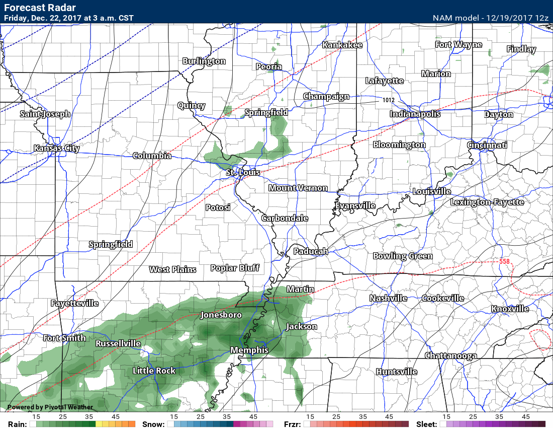
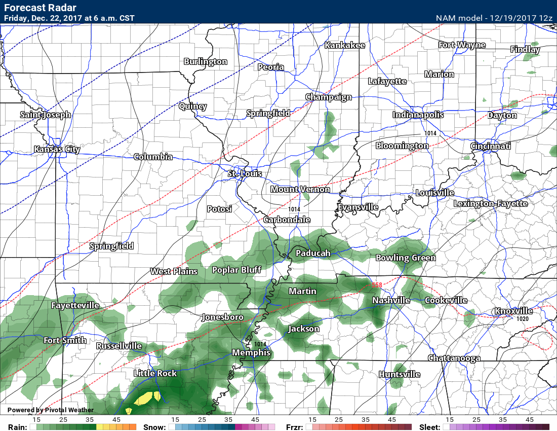
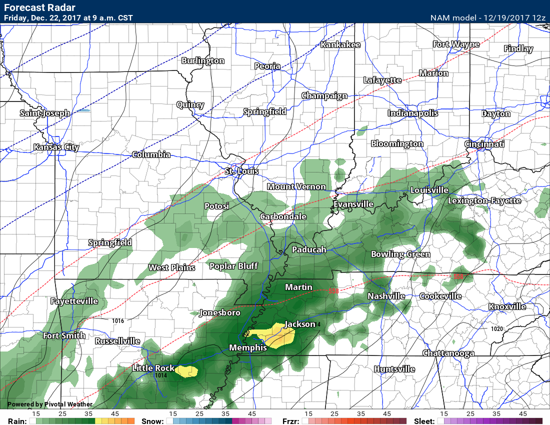
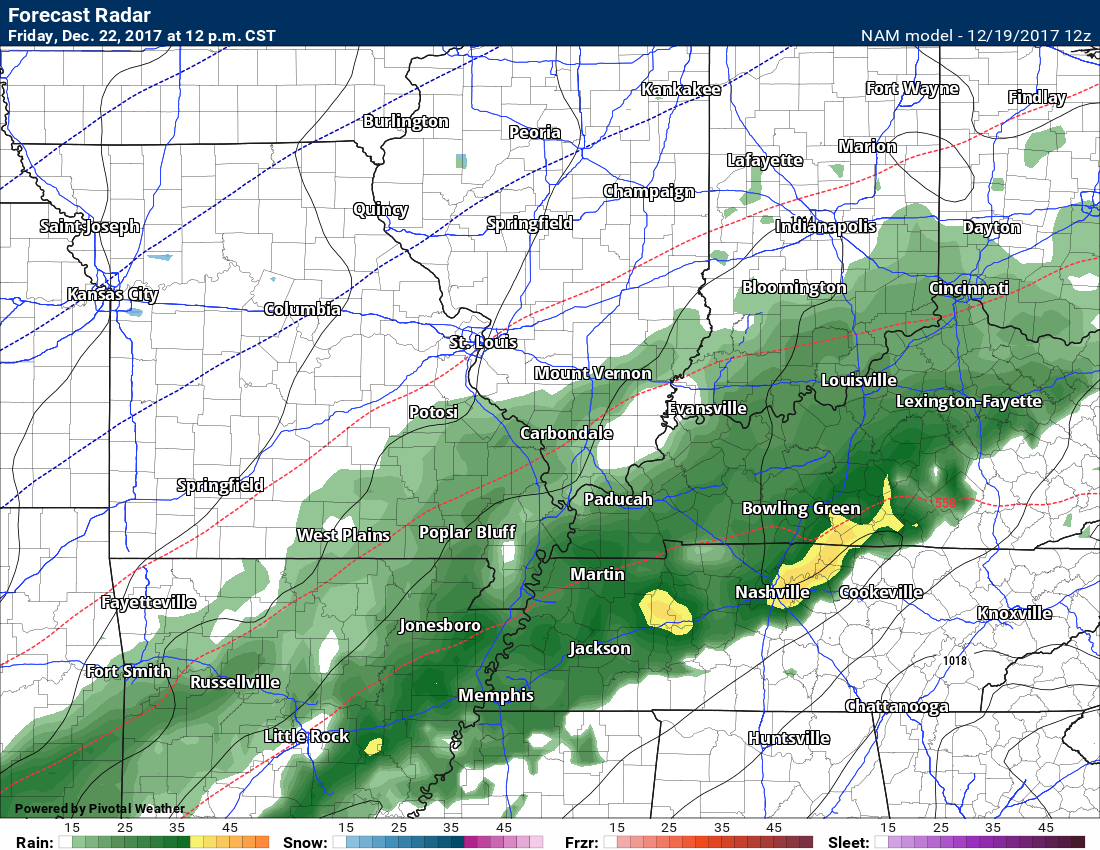
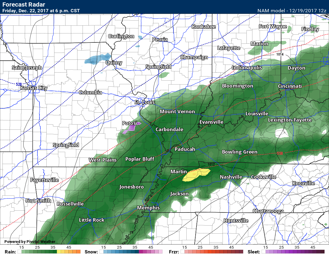
Here is the future-cast radar for Friday. Rain may move into the area during the morning hours. Colder air will trail the system and that might change the rain to a wintry mix across portions of the area Friday night.
THESE MAPS ARE NOT A FORECAST. It is simply a map from the NAM model. Models are not gospel, they are guidance.
3 AM Friday
.
.
6 AM Friday
.
.
9 AM Friday
.
.
12 PM Friday
.
.
6 PM Friday
.
.
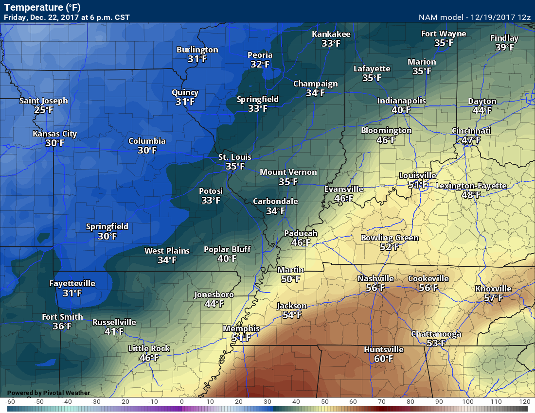
Here comes the colder air on Friday evening.
6 PM temperature map
.
.
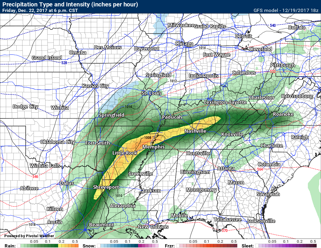
Meanwhile, the GFS guidance is stronger and colder with the Friday and Saturday system.
Here is the map 6 PM Friday
THESE MAPS ARE NOT A FORECAST. It is simply a map from the GFS model. Models are not gospel, they are guidance.
Blue would be snow.
.
.
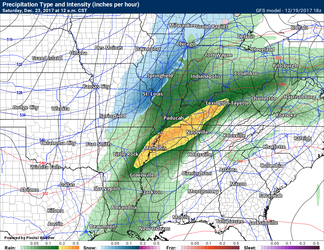
Here is the 12 AM Saturday map
.
.
Here is the 6 AM Saturday map
.
.
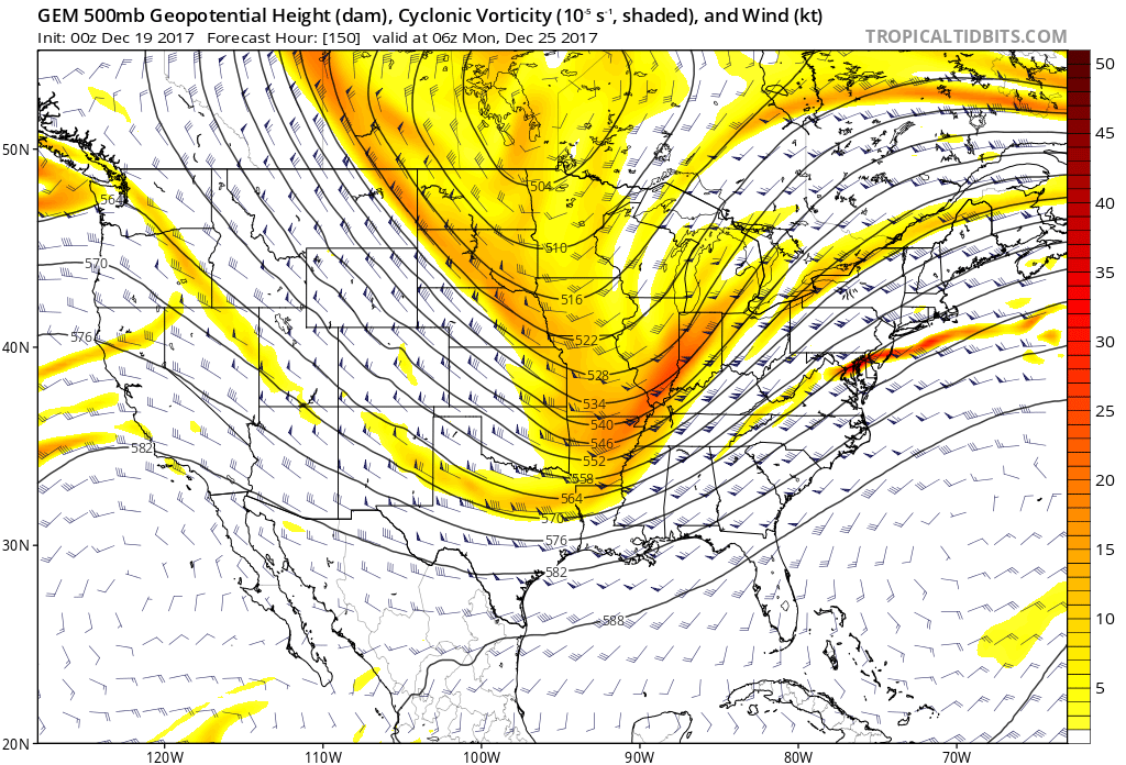
I am tracking a series of disturbances that will move through the region this weekend into next week.
Model guidance has been all but useless with this setup.
These systems are fast moving and models are not handling them all that well. Models also are not handling the cold temperatures.
Typically models struggle with shallow cold air. This causes forecast headaches.
We have one disturbance that may bring snow to the area Sunday night and Monday. Confidence remains low in the eventual outcome of this system. Monitor updates.
Here is the system on the 500 mb vort map from the Canadian model guidance.
You can see those yellows and reds. Those are disturbances moving through the fast jet stream flow.
This particular model is even showing a partial phasing. If true, that would increase snow chances in or near our region on Sunday night and Christmas Day. Those wanting a white Christmas should not give up hope. There is at least a chance.
.
.
The surface map reflects that potential of snow. This map is for Christmas Eve.
.
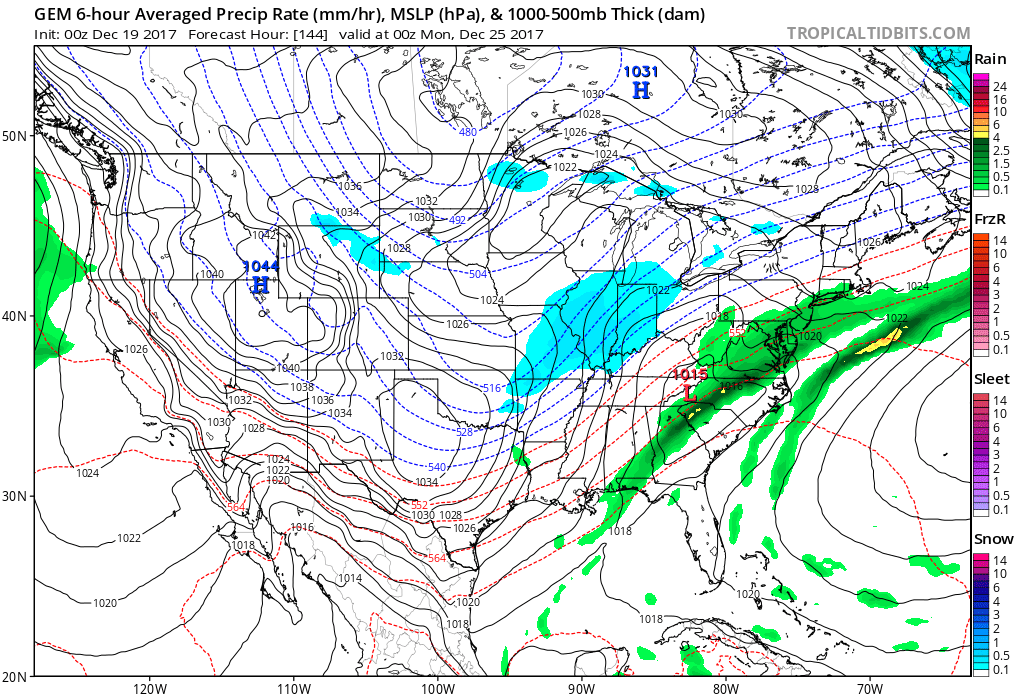
Monitor updates.
A couple of disturbances are possible next week. Still early for confidence levels to rise.
.
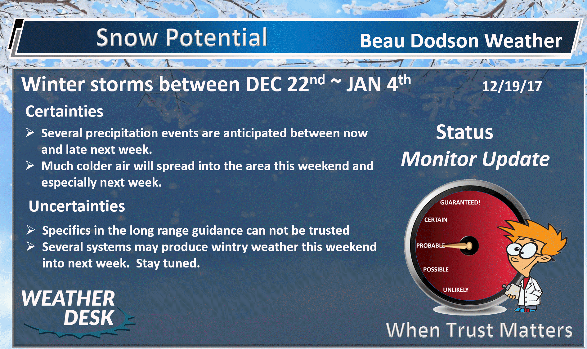
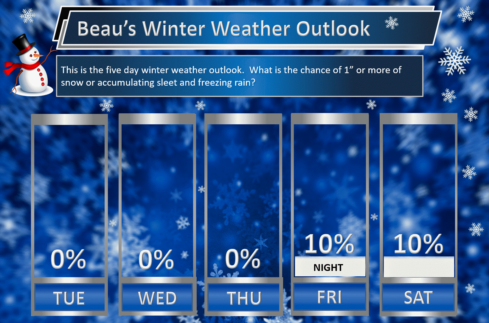
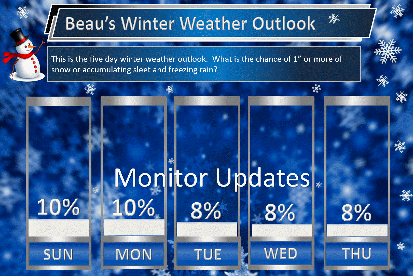
Beau’s Winter Weather Outlook
It is important to remember that this pattern is fluid. There is always going to be lower than normal confidence, during the winter months, for the forecast past day three or four.
.
.
Here are my latest snow probability maps for the week ahead.
These have been updated with the latest data.
These graphics show you the % chance of one inch or more of snow and/or accumulating sleet and freezing rain.
I do not anticipate winter weather through Friday evening. I will monitor late Friday night/Saturday for a brief change-over to snow. Low confidence.
.
.
Christmas week. Model guidance shows a very active pattern that could mean multiple precipitation events. Monitor updates moving forward. Confidence is low (it is in the long range).
Keep in mind, I rarely go above 10% chances past day five. That means 10% is a max number for days six through ten.
.
.
The pattern remains favorable for wintry weather. The question is going to be storm track and the placement of a boundary in or near our region.
.


We offer regional radars and local city radars – if a radar does not update then try another one. Occasional browsers need their cache cleared. You may also try restarting your browser. This will usually fix any problems.
During the winter you can track snow and ice by clicking the winterize button on the local city view interactive radars.
You may email me at beaudodson@usawx.com
Interactive Weather Radar Page. Choose the city nearest your location: Click this link
National interactive radar: Click this link.