
.
Your daily forecast into the coming weekend.
Monday Night Forecast Details:
Forecast: Quite a few clouds. A slight chance of light rain. Clouds may thin from west to east.
Temperatures: MO ~ 42 to 46 IL ~ 40 to 45 KY ~ 43 to 46
Wind chill values: 35 to 45
Accumulating snow or ice: No
Winds: Southwest winds at 5 to 10 mph
What impacts are anticipated from the weather? Most likely none, but I will monitor a slight chance of precipitation
My confidence in the forecast verifying: Medium
Is severe weather expected? No
The NWS defines severe weather as 58 mph wind or great, 1″ hail or larger, and/or tornadoes
What is the chance of precipitation? MO ~ 20% IL ~ 20% KY ~ 20%
Coverage of precipitation: None to isolated
Should I cancel my outdoor plans: No
.
Tuesday Night Forecast Details:
Forecast: Cloudy. Rain likely over at least the southern half of the region. Greatest coverage will be from Poplar Bluff towards Cape Girardeau and then towards Vienna, Illinois and then eastward towards Madisonville, Kentucky. From there southward the coverage will be greater than areas to the north.
Temperatures: MO ~ 40 to 45 IL ~ 38 to 44 KY ~ 43 to 46
Wind chill values: 30’s and 40’s
Accumulating snow or ice: No
Winds: North and northeast winds at 5 to 10 mph
What impacts are anticipated from the weather? Wet roadways
My confidence in the forecast verifying: High
Is severe weather expected? No
The NWS defines severe weather as 58 mph wind or great, 1″ hail or larger, and/or tornadoes
What is the chance of precipitation? MO ~ 60% south a 30% north IL ~ 60% south and 30% north KY ~ 70% along the KY/TN border and 30% near the KY/IN border
Coverage of precipitation: Scattered early and widespread late
Should I cancel my outdoor plans: Monitor radars
.
December 20, 2017
Wednesday Forecast Details
Forecast: Mostly cloudy with showers possible, especially before 10 am. Greater coverage over our southern counties (Bootheel into the KY/TN border area). Becoming partly cloudy during the afternoon.
Temperatures: MO ~ 46 to 54 IL ~ 46 to 54 KY ~ 46 to 54
Wind chill values: N/A
Accumulating snow or ice: No
Winds: Northeast 5 to 10 mph with gusts to 12 mph
What impacts are anticipated from the weather? Wet roadways
My confidence in the forecast verifying: High
Is severe weather expected? No
The NWS defines severe weather as 58 mph wind or great, 1″ hail or larger, and/or tornadoes
What is the chance of precipitation? MO ~ 60% south and 30% north IL ~ 60% south and 30% north KY ~ 70% near KY/TN border and 30% near the KY/IN border
Coverage of precipitation: Scattered to widespread. Widespread would be our southern counties (as mentioned above).
Should I cancel my outdoor plans? Monitor radars
.
December 20, 2017
Wednesday Forecast Details
Forecast: Mostly cloudy with showers possible. Greater coverage over our southern counties (Bootheel into the KY/TN border area). Becoming partly cloudy during the afternoon.
Temperatures: MO ~ 46 to 54 IL ~ 46 to 54 KY ~ 46 to 54
Wind chill values: N/A
Accumulating snow or ice: No
Winds: Northeast 5 to 10 mph with gusts to 12 mph
What impacts are anticipated from the weather? Wet roadways
My confidence in the forecast verifying: High
Is severe weather expected? No
The NWS defines severe weather as 58 mph wind or great, 1″ hail or larger, and/or tornadoes
What is the chance of precipitation? MO ~ 60% IL ~ 60% KY ~ 80%
Coverage of precipitation: Scattered to widespread. Widespread would be our southern counties (as mentioned above).
Should I cancel my outdoor plans? Monitor radars
.
Wednesday Night Forecast Details:
Forecast: Clearing. Colder. Patchy fog possible.
Temperatures: MO ~ 30 to 35 IL ~ 30 to 35 KY ~ 30 to 35
Wind chill values: 25 to 35
Accumulating snow or ice: No
Winds: North and northeast winds at 4 to 8 mph
What impacts are anticipated from the weather? Patchy fog
My confidence in the forecast verifying: High
Is severe weather expected? No
The NWS defines severe weather as 58 mph wind or great, 1″ hail or larger, and/or tornadoes
What is the chance of precipitation? MO ~ 0% IL ~ 0% KY ~ 0%
Coverage of precipitation: None
Should I cancel my outdoor plans: No
.
December 21, 2017
Thursday Forecast Details
Forecast: Mostly sunny with a few passing clouds. Warmer
Temperatures: MO ~ 54 to 58 IL ~ 54 to 58 KY ~ 54 to 58
Wind chill values: N/A
Accumulating snow or ice: No
Winds: South winds at 5 to 10 mph
What impacts are anticipated from the weather? None
My confidence in the forecast verifying: High
Is severe weather expected? No
The NWS defines severe weather as 58 mph wind or great, 1″ hail or larger, and/or tornadoes
What is the chance of precipitation? MO ~ 0% IL ~ 0% KY ~ 0%
Coverage of precipitation: None
Should I cancel my outdoor plans? No
.
Thursday Night Forecast Details:
Forecast: Increasing clouds. A chance of late night showers.
Temperatures: MO ~ 45 to 50 IL ~ 45 to 50 KY ~ 45 to 50
Wind chill values: 40’s
Accumulating snow or ice: No
Winds: South and southwest winds at 5 to 10 mph
What impacts are anticipated from the weather? Perhaps wet roadways
My confidence in the forecast verifying: High
Is severe weather expected? No
The NWS defines severe weather as 58 mph wind or great, 1″ hail or larger, and/or tornadoes
What is the chance of precipitation? MO ~ 30% IL ~ 30% KY ~ 20%
Coverage of precipitation: Scattered
Should I cancel my outdoor plans: No
.
December 22, 2017
Friday Forecast Details
Forecast: Mostly cloudy. A chance of showers and perhaps thunderstorms. Breezy and warmer.
Temperatures: MO ~ 56 to 62 IL ~ 56 to 62 KY ~ 56 to 62
Wind chill values: N/A
Accumulating snow or ice: No
Winds: South and southwest at 8 to 16 mph and gusty
What impacts are anticipated from the weather? Lightning, gusty winds, and wet roadways.
My confidence in the forecast verifying: Medium
Is severe weather expected? Strong storms can’t be ruled out
The NWS defines severe weather as 58 mph wind or great, 1″ hail or larger, and/or tornadoes
What is the chance of precipitation? MO ~ 40% IL ~ 50% KY ~ 50%
Coverage of precipitation: Scattered to widespread
Should I cancel my outdoor plans? Have a plan B
.
Friday Night Forecast Details:
Forecast: Mostly cloudy. Showers possible. An evening thunderstorm possible. Rain may mix with or change to snow after midnight. Turning colder late. Breezy.
Temperatures: MO ~ 28 to 34 IL ~ 30 to 34 KY ~ 30 to 35
Wind chill values: 20 to 30
Accumulating snow or ice: Monitor updates
Winds: Southwest winds becoming west and northwest at 7 to 14 mph. Gusty winds possible.
What impacts are anticipated from the weather? Wet roadways. I will monitor the snow potential.
My confidence in the forecast verifying: LOW
Is severe weather expected? Monitor updates
The NWS defines severe weather as 58 mph wind or great, 1″ hail or larger, and/or tornadoes
What is the chance of precipitation? MO ~ 40% IL ~ 50% KY ~ -50%
Coverage of precipitation: Scattered to perhaps widespread
Should I cancel my outdoor plans: Have a plan B
.
December 23, 2017
Saturday Forecast Details
Forecast: Clouds early. Becoming partly sunny. Snow showers possible. Colder.
Temperatures: MO ~ 40 to 45 IL ~ 38 to 44 KY ~ 40 to 45
Wind chill values: 30’s
Accumulating snow or ice: Monitor updates
Winds: Northwest at 10 to 20 mph
What impacts are anticipated from the weather? Most likely none, but monitor updates
My confidence in the forecast verifying: LOW
Is severe weather expected? No
The NWS defines severe weather as 58 mph wind or great, 1″ hail or larger, and/or tornadoes
What is the chance of precipitation? MO ~ 30% IL ~ 30% KY ~ 30%
Coverage of precipitation: Scattered
Should I cancel my outdoor plans? Monitor updates
.
Saturday Night Forecast Details:
Forecast: Mostly cloudy. Cold. Snow showers or flurries possible.
Temperatures: MO ~ 24 to 28 IL ~ 24 to 28 KY ~ 24 to 28
Wind chill values: 20 to 25
Accumulating snow or ice: No
Winds: North and northwest at 5 to 10 mph
What impacts are anticipated from the weather? None
My confidence in the forecast verifying: Medium
Is severe weather expected? No
The NWS defines severe weather as 58 mph wind or great, 1″ hail or larger, and/or tornadoes
What is the chance of precipitation? MO ~ 20% IL ~ 20% KY ~ 20%
Coverage of precipitation:
Should I cancel my outdoor plans: No
.
December 24, 2017
Sunday Forecast Details
Forecast: Some clouds. Snow showers possible.
Temperatures: MO ~ 35 to 40 IL ~ 35 to 40 KY ~ 35 to 40
Wind chill values: 30’s
Accumulating snow or ice: Monitor updates
Winds: Northwest at 6 to 12 mph
What impacts are anticipated from the weather? Most likely none, but monitor updates
My confidence in the forecast verifying: LOW
Is severe weather expected? No
The NWS defines severe weather as 58 mph wind or great, 1″ hail or larger, and/or tornadoes
What is the chance of precipitation? MO ~ 30% IL ~ 30% KY ~ 30%
Coverage of precipitation: Scattered
Should I cancel my outdoor plans? Monitor updates
.
Sunday Night Forecast Details:
Forecast: Mostly cloudy. Cold. Snow showers possible.
Temperatures: MO ~ 20 to 25 IL ~ 20 to 25 KY ~ 20 to 25
Wind chill values: 15 to 25
Accumulating snow or ice: Monitor updates
Winds: West and northwest at 5 to 10 mph
What impacts are anticipated from the weather?
My confidence in the forecast verifying: LOW
Is severe weather expected? No
The NWS defines severe weather as 58 mph wind or great, 1″ hail or larger, and/or tornadoes
What is the chance of precipitation? MO ~ 30% IL ~ 40% KY ~ 30%
Coverage of precipitation: Scattered, but monitor updates
Should I cancel my outdoor plans: Monitor updates
Christmas Day: Cloudy with a chance of snow. High temperatures 30 to 35.
.

.
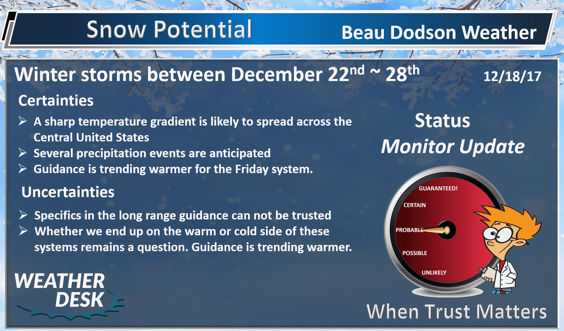
Monday night through next Thursday: High confidence. The risk for freezing rain, sleet, and snow is near zero.
Friday through Tuesday: Low confidence. Wintry precipitation can’t be ruled out Friday night and Saturday morning. At this time, the chance of accumulation appears small. Monitor updates.
A winter storm may develop late Sunday into Christmas Day. This system is forecast to deliver a wintry mix. The track of the system is unclear. Monitor updates. I can’t rule out our region being impacted by this system.
.

.
The National Weather Service definition of a severe thunderstorm is one that produces quarter size hail or larger, 58 mph winds or greater, and/or a tornado.
Monday night through Thursday: High confidence. Severe weather is unlikely. Lightning will be possible on Tuesday afternoon into Wednesday morning.
Friday and Friday night: Medium confidence. A stronger system will develop across the Central United States on Friday into Friday night. Showers and thunderstorms will be possible along an incoming cold front. I can’t rule out strong thunderstorms. Monitor updates.
.

.
December 18th and 19th, 2017
Forecast
Interactive Weather Radar Page. Choose the city nearest your location: Click this link
A complicated forecast over the coming seven to fourteen days. We have multiple systems to track. Let’s break it down.
Tonight into Tuesday morning
Low temperatures tonight will drop into the upper 30’s and lower 40’s. Clouds and patchy fog are possible tonight, as well.
Temperatures will remain above freezing. I can’t rule out some drizzle.
Tuesday afternoon into Wednesday night
Our next storm system will already be knocking on our door by Tuesday morning and afternoon. Clouds will increase from the south and rain will develop in Arkansas and the Tennessee Valley.
It will be mild on Tuesday with temperatures in the 56 to 62 degree range. Well above normal.
I can’t rule out a few rumbles of thunder with this event, as well. The risk for severe weather is near zero.
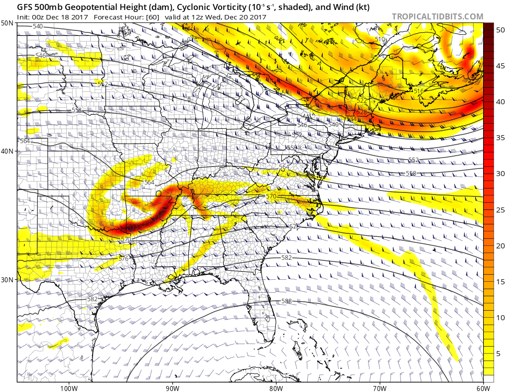
Here is the 500 mb vort map for Wednesday. The bright colors are areas will lift is occurring. This is our storm system.
.
.
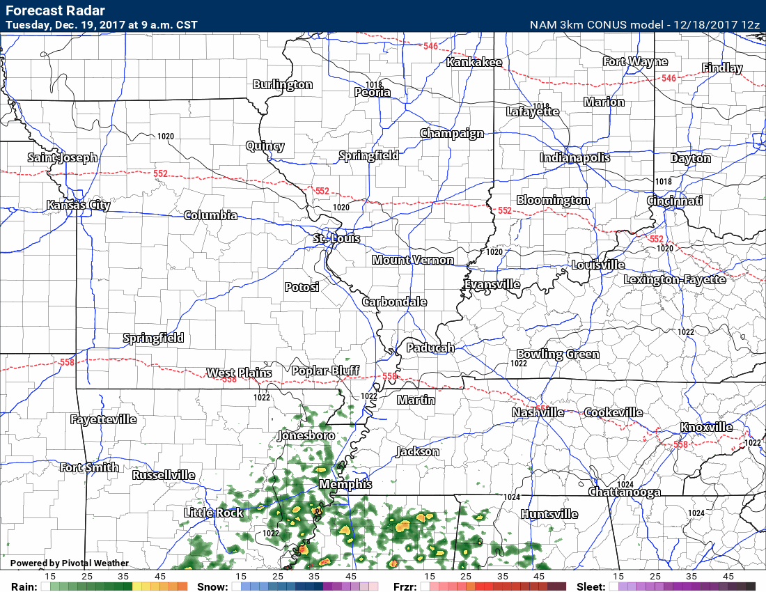
Here is the future-cast radar from the NAM model guidance. There is some question about rain showers on Tuesday (before 5 pm).
Time stamp upper left portion of the image.
Most of the rain will likely occur Tuesday night into Wednesday morning. I will keep an eye on the timing.
.
.
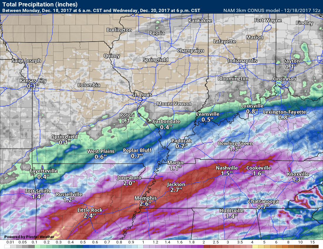
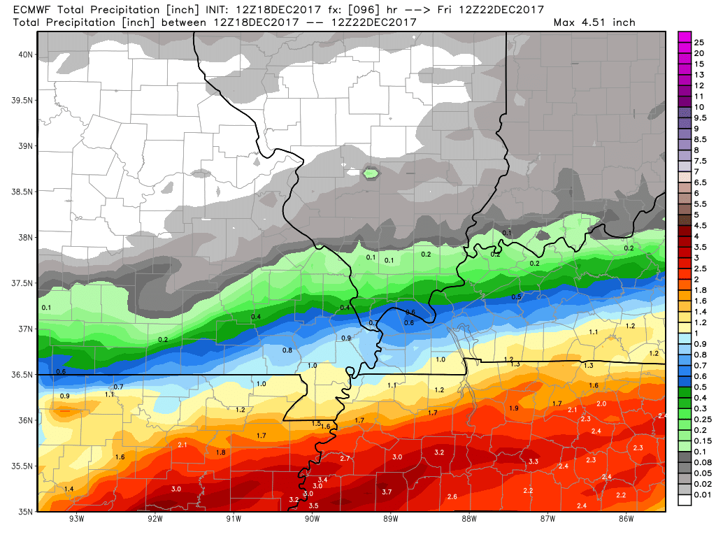
As far as rainfall totals. This could be a moderate rain event for portions of the region.
The system has trended a bit further north over the last two days.
Here is the NAM model guidance rainfall outlook.
Light totals are forecast across the northern half of the area. Heavier totals across the Missouri Bootheel into portions of western Kentucky and Tennessee.
SHARP cut-off on rain totals.
Adjustments would be necessary if the system shifts a bit further north. Medium confidence on the map below.
.
.
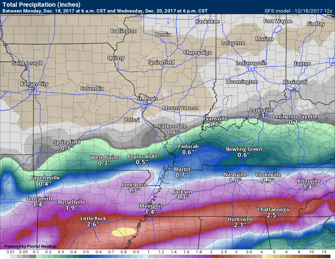
Here is the GFS model guidance. It is similar to the NAM. Again, notice the sharp precipitation totals gradient.
.
.
Here is the EC model guidance rainfall totals. Click image to enlarge.
.
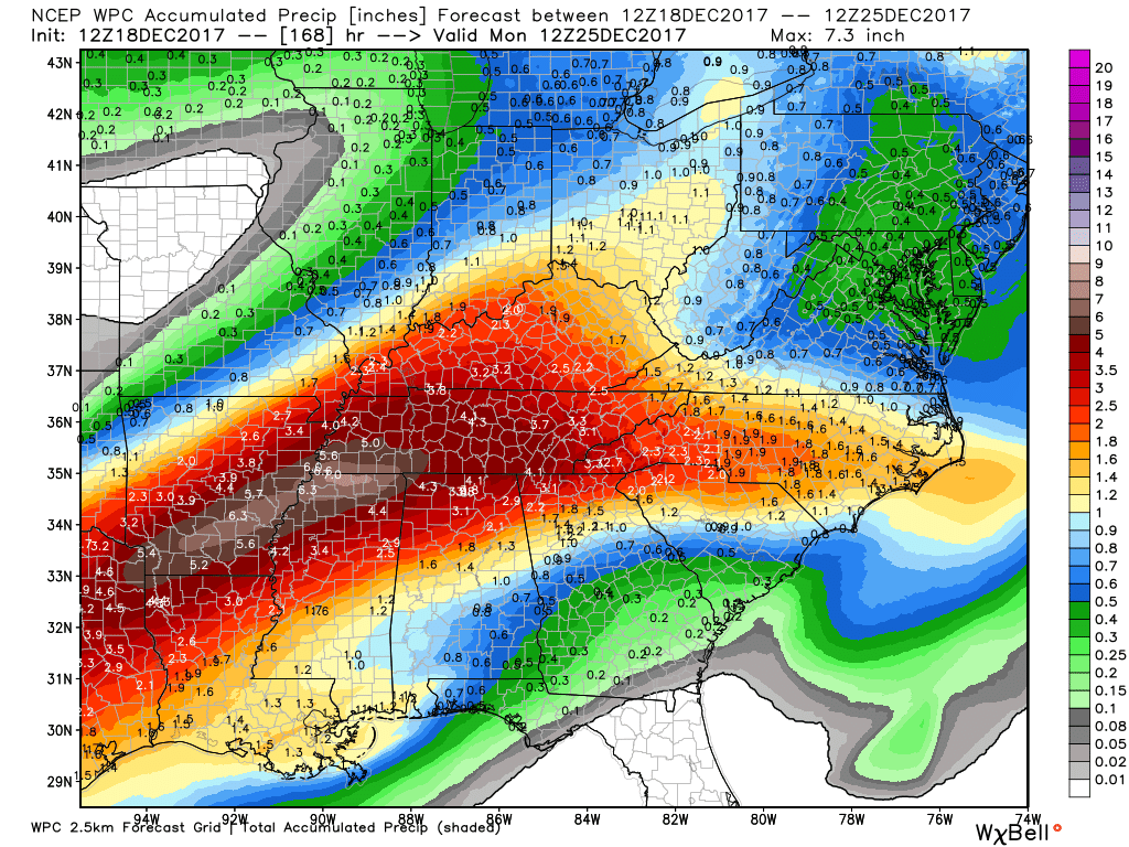
Here is the NOAA/WPC forecast totals
This is for the Tuesday/Wednesday system only.
.
.
Thursday
Thursday should remain dry. Perhaps some clouds. Temperatures are forecast to rise into the middle to upper 50’s.
Friday
Our next system will move into the region on Friday and Friday night. This will be the system to delivers colder air to the region.
I have been monitoring this system for about a month.
Almost all of the guidance has trended towards a deeper low to our north. That would mean warm air in our region with rain and perhaps thunderstorms.
There is some debate about how widespread the rain coverage will be on Friday and Friday night. This part of the forecast will need fine tuning.
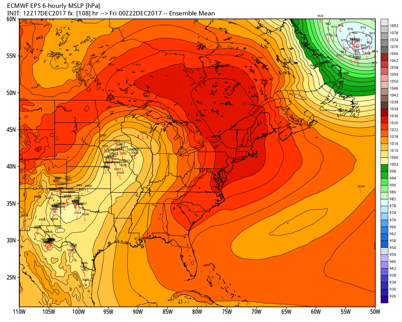
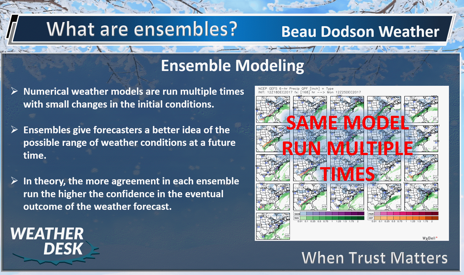
Here is the EC ensemble map tracking the area of low pressure. Ensembles are the same model repeatedly run with different initial variables. The idea is that if most of the ensembles agree, then the confidence in the forecast will be higher.
The track of this low will keep us in the warm sector.
You can see the little red L’s. Nice clustering of the L’s. That means a higher than normal confidence on the eventual track of the area of low pressure. Either way, this keeps us in the warm sector of this system.
.
.
The risk for snow and ice through Friday is near zero. I can’t rule out a brief change to snow behind the cold front late Friday night into Saturday. This is questionable, for the time being.
Let’s take a look at some of the charts.
Dew points will rise into the upper 50’s and lower 60’s ahead of the cold front. That is quite a bit of moisture for December. We might need to think about thunderstorms.
It is a bit early to know if severe weather will be a concern. For now, the risk appears to be small. Monitor updates.
Here is the Friday dew point map. Notice how the system pulls moisture northward from the Gulf of Mexico.
.

.
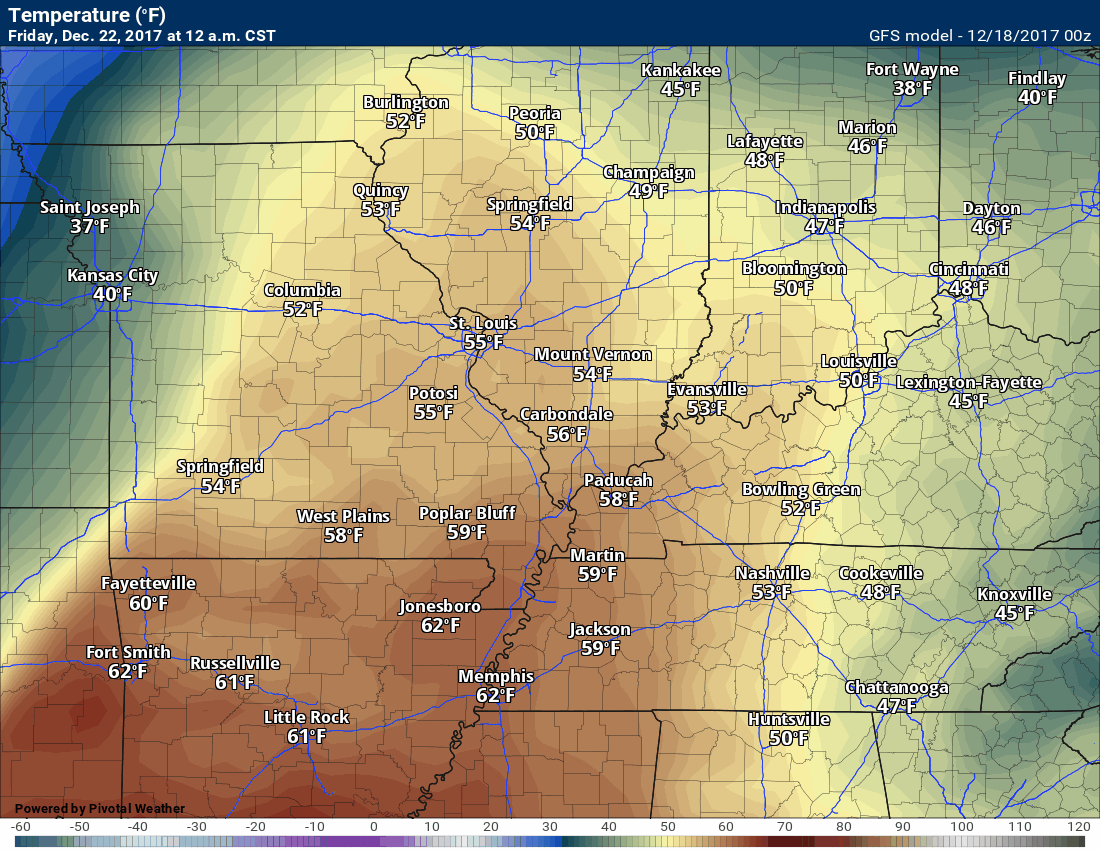
Here is the Friday temperature animation. Notice the colder air pushing in behind the cold front.
.
.
These next maps are the precipitation maps. This is the six hour precipitation rate.
This first map is for Thursday 6 PM.
You can see the red L. That is the area of low pressure. It is located near Kansas City, Missouri. It is moving northeast.
That places our region in the warm sector. Remember, lows rotate counter-clockwise. Thus, they pull warm air northward from the Gulf of Mexico.
The blue represents snow. Light blue is light snow. Dark blue is heavier snow. Pink and red would be ice. Green would be rain. Yellow would be heavier rain.
It is possible that quite a bit of this precipitation event will end up over the eastern half of our region. That will need to be monitored. Rain totals might be less over SE MO than say the Pennyrile area of western Kentucky.
.
.
This next map is Friday at 12 AM. The low has deepened and continues to track northeast. A cold front will trail back into Oklahoma. Some showers and thunderstorms should form ahead of the cold front. Not much showing up on the GFS at midnight on Friday.
.
.
This next map is for 6 AM Friday. You can see a mature storm system with heavy snow well to our north. A trailing band of showers and thunderstorms back into Missouri.
.
.
This next graphic is for 12 PM Friday. The low continues to move northeast. A cold front will be pushing through our region. The timing of all of this will need to be monitored.
Showers and thunderstorms should be occurring ahead of the front in our local region.
.
.
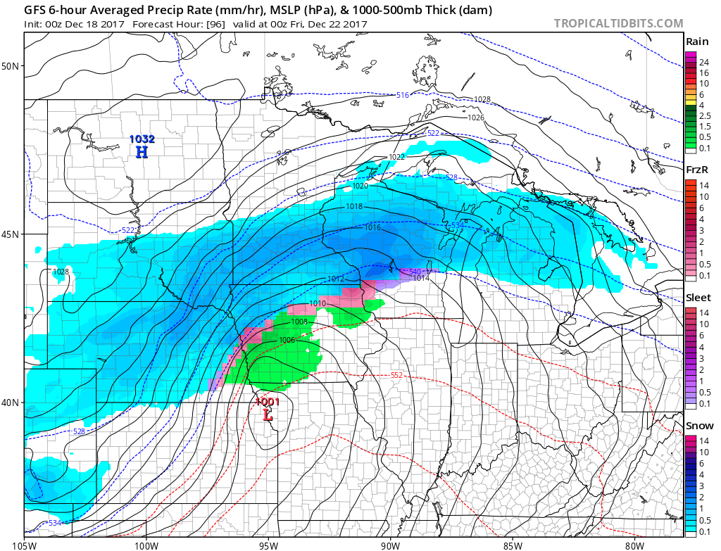
This next map is for 6 PM Friday. The system continues to move northeast into Canada. Rain in our local area.
Those brighter colors in Kentucky and Tennessee represent heavy downpours.
.
.
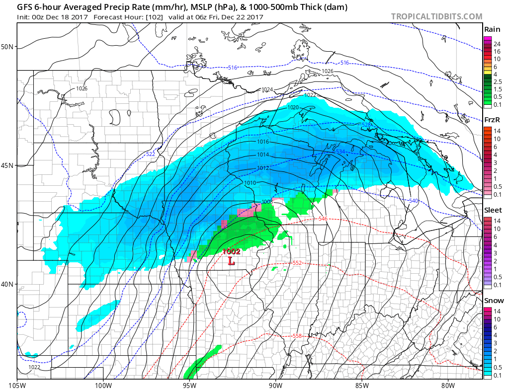
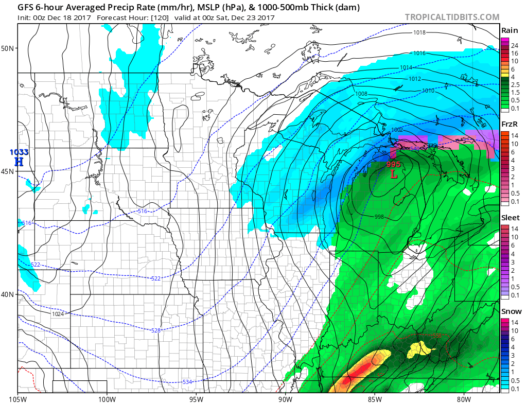
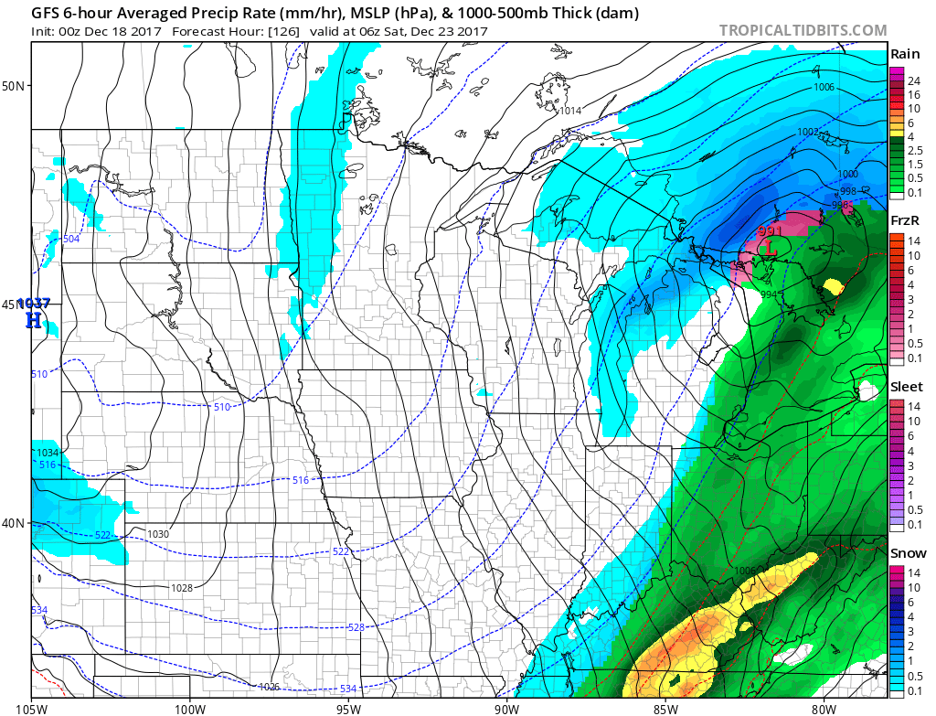
This next image is 12 AM Saturday.
The GFS shows a brief change-over to light snow. This is questionable. I will keep an eye on trends.
.
. .
.
.
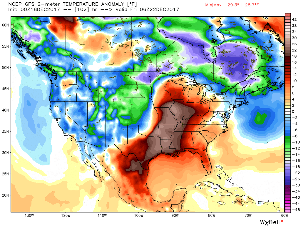
Let me show you the temperature anomaly maps. These maps show you how many degrees above or below normal temperatures will be.
Well above normal ahead of the cold front.
Notice the surge of red and tan colors into our region ahead of the front.
Friday
.
.
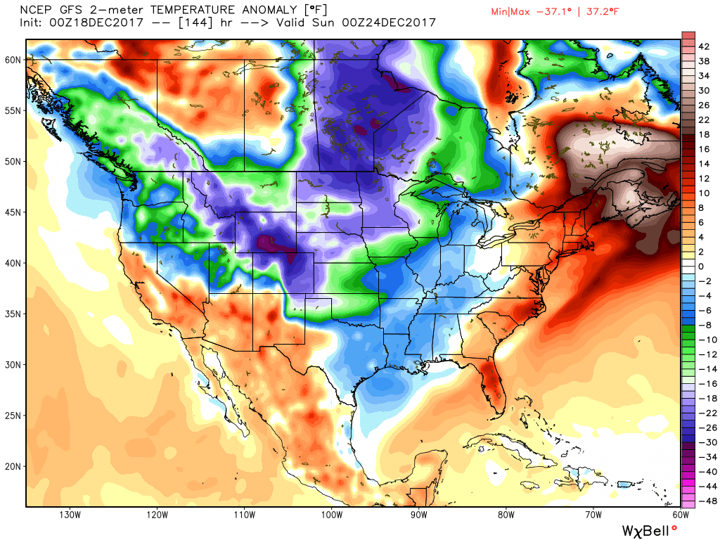
Then on Saturday we dip below normal in the temperature department. Temperatures may remain in the 30’s for highs Saturday afternoon.
.
.
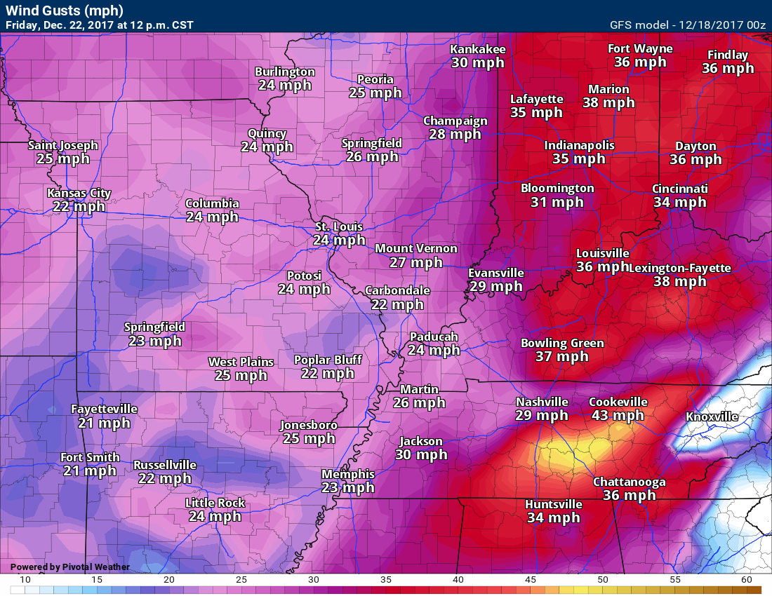
We will have gusty winds on Thursday into Saturday. Highest winds will likely be on Friday. We could see wind gusts into the 30 to 35 mph range. The wind gusts will depend on the strength of the area of low pressure.
.
Wind gust map for 12 PM Friday.
.
.
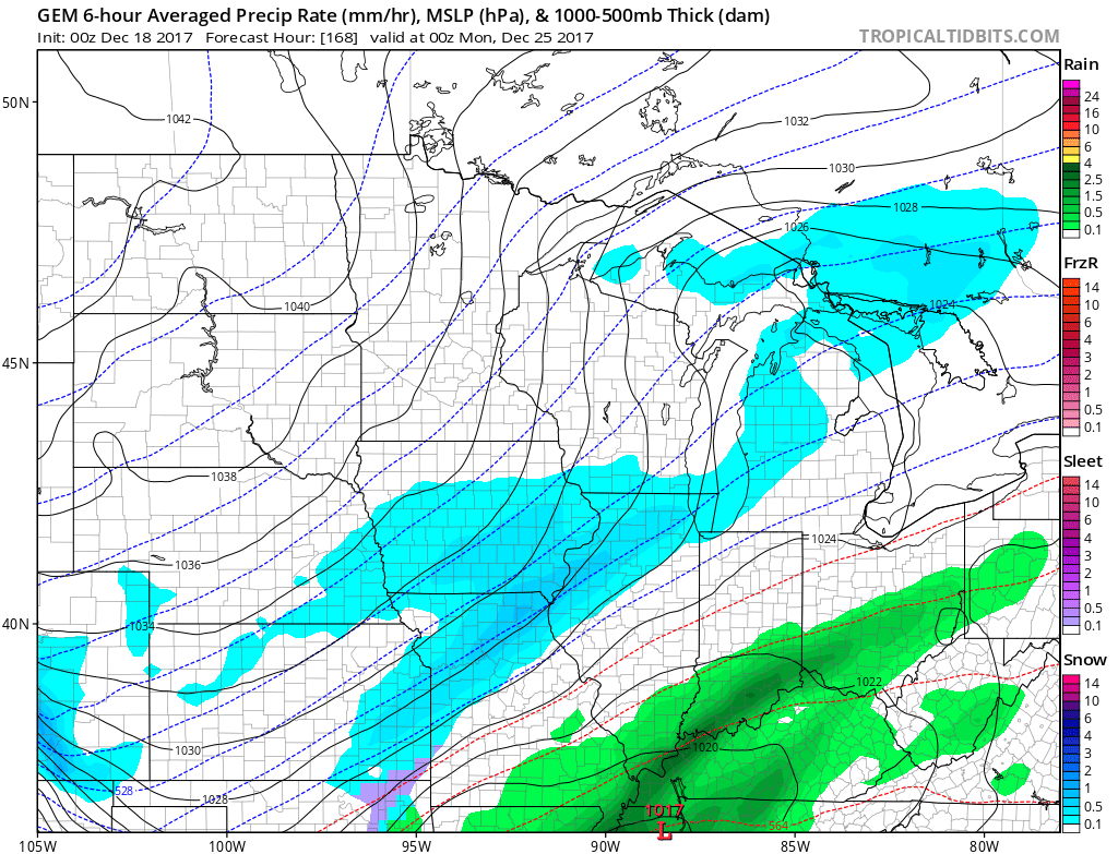
The weather may remain active into the weekend and next week.
I am monitoring several waves of low pressure. Each one could produce precipitation. Whether we manage to end up with a wintry mix or all rain is still a question. Whether the system even impact our region is a question.
.
The Canadian model generates enough lift for snow to develop to our west on Sunday. This will need to be monitored.
.

.
Here is the Sunday night map. Rain? Wintry mix? Nothing at all? Too soon to know.
.
.
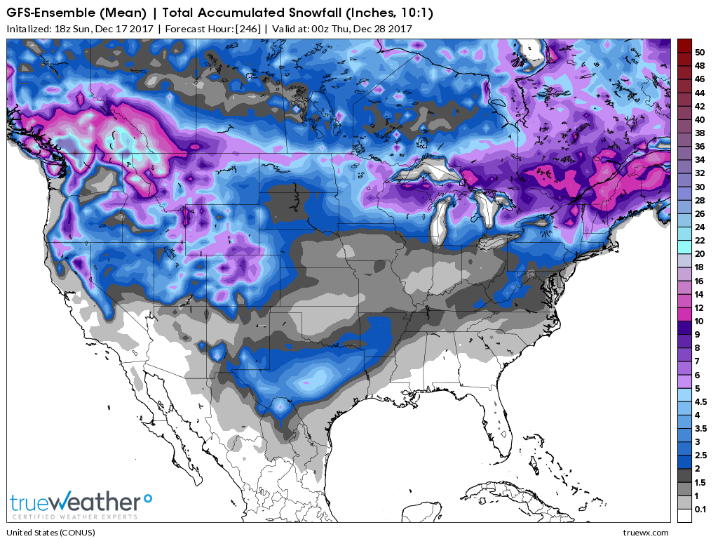
Bitterly cold air is possible next week. Still a bit early to know how cold, but single digits can’t be ruled out. This will partly depend on snow cover.
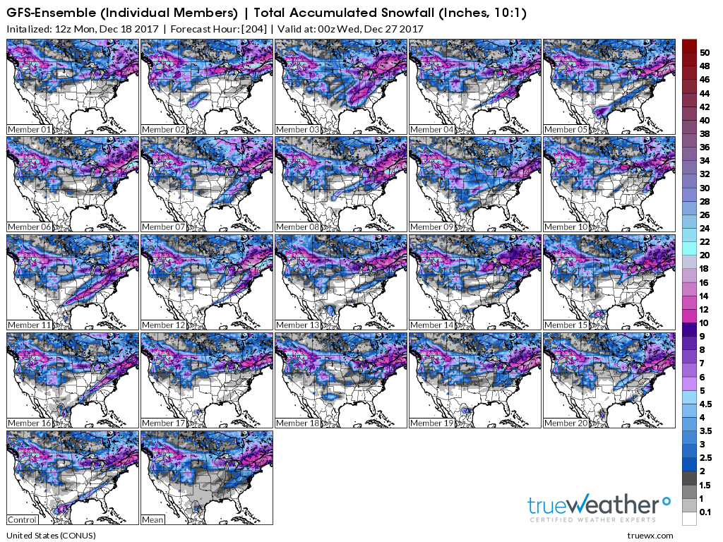
Here is the GFS ensemble mean snowfall totals through the 27th.
Basically, this graphic takes all the GFS ensembles and determines the mean.
It is showing at least the POTENTIAL of some snow in our region. No promises.
.
.
The individual ensemble members are showing the potential for a snow event around Christmas.
Low confidence.
This map shows you each ensemble member. Again, ensembles are the same model run over and over again with slightly different beginning variables.
In theory, the more that agree the higher the confidence in the forecast.
.
.
Several of the ensembles do show a snow event around Christmas. Just too far out for confidence levels to be all that great.
Click to enlarge.
.
The pattern remains active for winter storms. It is just a matter of one of the systems being able to tap into the cold air. We will have cold air in place.
The pattern should remain active into the first part of January. If you are a snow fan, then there is quite a bit to monitor.
.
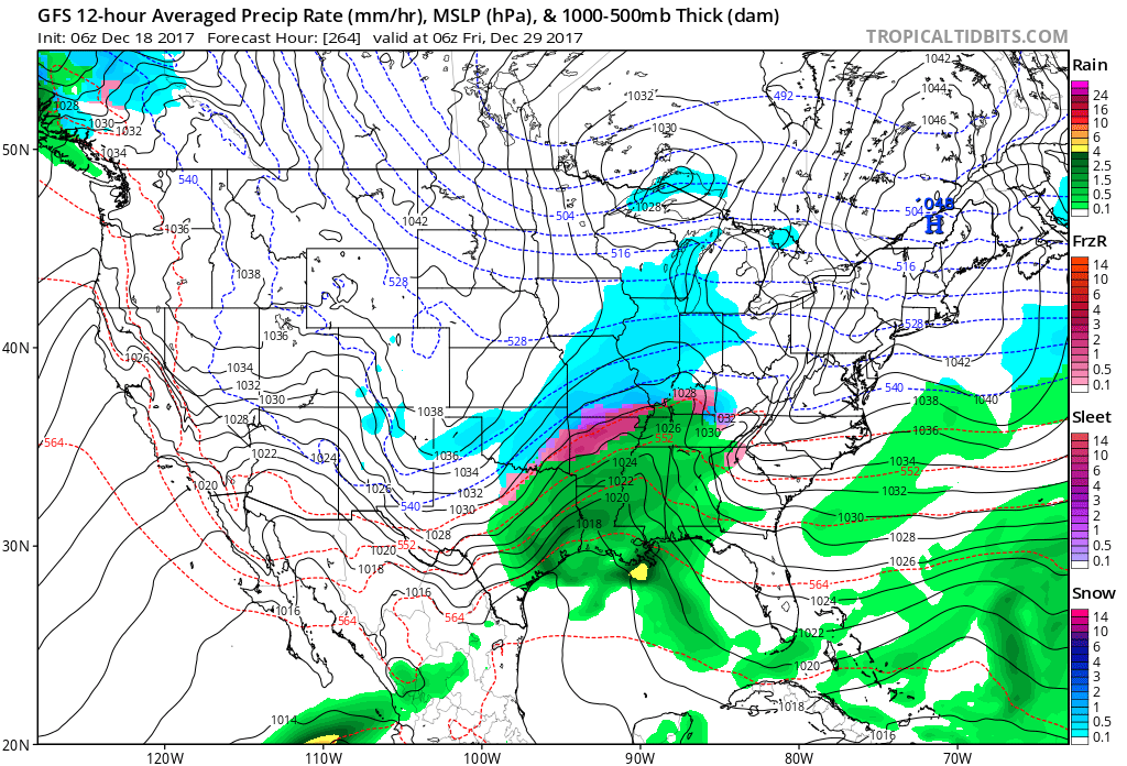
The GFS guidance is showing another system around the 28th/29th and another around the 1st/2nd. Too far out to know if these systems will actually verify. I am just showing you that the pattern is active.
.
.
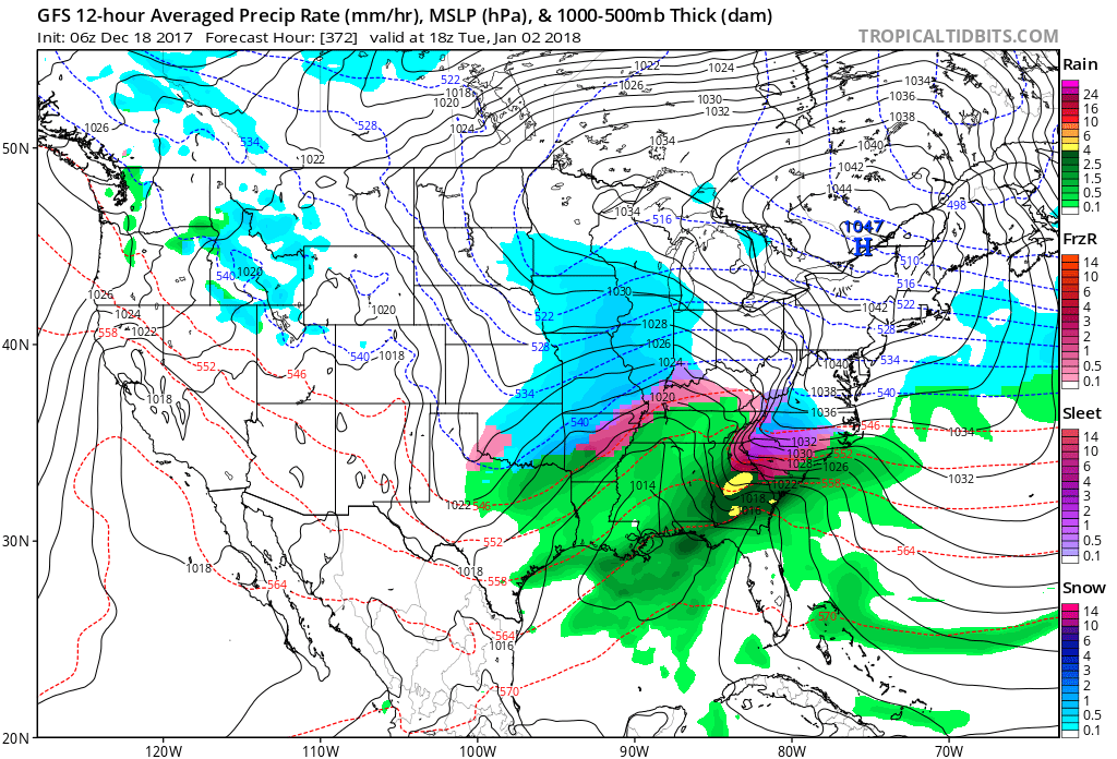
Another around the 1st/2nd
.
.
.
Beau’s Winter Weather Outlook
It is important to remember that this pattern is fluid. There is always going to be lower than normal confidence, during the winter months, for the forecast past day three or four.
.
.
Here are my latest snow probability maps for the week ahead.
These have been updated with the latest data.
These graphics show you the % chance of one inch or more of snow and/or accumulating sleet and freezing rain.
I do not anticipate winter weather through Friday evening. I will monitor late Friday night/Saturday for a brief change-over to snow. Low confidence on that occurring.
.
.
Christmas week. Model guidance shows a very active pattern that could mean multiple precipitation events. Monitor updates moving forward. Confidence is low (it is in the long range).
Keep in mind, I rarely go above 10% chances past day five. That means 10% is a max number for days six through ten.
.
.
The pattern remains favorable for wintry weather. The question is going to be storm track and the placement of a boundary in or near our region.
This boundary will separate cold air from warmer air.
.


We offer regional radars and local city radars – if a radar does not update then try another one. Occasional browsers need their cache cleared. You may also try restarting your browser. This will usually fix any problems.
During the winter you can track snow and ice by clicking the winterize button on the local city view interactive radars.
You may email me at beaudodson@usawx.com
Interactive Weather Radar Page. Choose the city nearest your location: Click this link
National interactive radar: Click this link.