
.
Your daily forecast into the coming weekend.
.
December 15, 2017
Friday Night Forecast Details:
Forecast: Mostly clear. A few passing clouds. Chilly temperatures.
Temperatures: MO ~ 25 to 30 IL ~ 25 to 30 KY ~ 28 to 34
Wind chill values: 20’s
Accumulating snow or ice: No
Winds: South and southwest winds 4 to 8 mph
What impacts are anticipated from the weather? None
My confidence in the forecast verifying: High
Is severe weather expected? No
The NWS defines severe weather as 58 mph wind or great, 1″ hail or larger, and/or tornadoes
Is freezing rain, sleet, or snow expected? None
What is the chance of precipitation? MO ~ 0% IL ~ 0% KY ~ 0%
Coverage of precipitation: None
Should I cancel my outdoor plans: No
.
December 16, 2017
Saturday Forecast Details
Forecast: Mostly sunny. Warmer. Clouds may increase during the afternoon.
Temperatures: MO ~ 52 to 56 IL ~ 52 to 55 KY ~ 52 to 56
Wind chill values: N/A
Accumulating snow or ice: No
Winds: South and southwest winds 8 to 16 mph with gusts above 25 mph
What impacts are anticipated from the weather? None
My confidence in the forecast verifying: High
Is severe weather expected? No
The NWS defines severe weather as 58 mph wind or great, 1″ hail or larger, and/or tornadoes
Is freezing rain, sleet, or snow expected? No
What is the chance of precipitation? MO ~ 0% IL ~ 0% KY ~ 0%
Coverage of precipitation: None
Should I cancel my outdoor plans? No
.
Saturday Night Forecast Details:
Forecast: Becoming cloudy. Breezy. Showers increasing from the south and west.
Temperatures: MO ~ 35 to 40 IL ~ 35 to 40 KY ~ 35 to 40
Wind chill values: 30 to 40
Accumulating snow or ice: No
Winds: South and southwest winds 7 to 14 mph with gusts to 25 mph
What impacts are anticipated from the weather? Wet roadways
My confidence in the forecast verifying: High
Is severe weather expected? No
The NWS defines severe weather as 58 mph wind or great, 1″ hail or larger, and/or tornadoes
Is freezing rain, sleet, or snow expected? None
What is the chance of precipitation? MO ~ 70% IL ~ 60% KY ~ 70%
Coverage of precipitation: Increasing coverage from the south and west.
Should I cancel my outdoor plans: No
.
December 17, 2017
Sunday Forecast Details
Forecast: Mostly cloudy. A period of gusty winds possible. Widespread rain is anticipated during the morning. Greatest coverage before 2 pm. Rain should decrease during the afternoon.
Temperatures: MO ~ 46 to 48 IL ~ 44 to 48 KY ~ 46 to 48
Wind chill values: N/A
Accumulating snow or ice: No
Winds: South and southwest becoming west and northwest at 6 to 12 mph with gusts to 18 mph. There is a chance of some stronger winds on Sunday, but confidence is low (on that subject).
What impacts are anticipated from the weather? Wet roadways. Maybe some gusty winds.
My confidence in the forecast verifying: High
Is severe weather expected? No
The NWS defines severe weather as 58 mph wind or great, 1″ hail or larger, and/or tornadoes
Is freezing rain, sleet, or snow expected? No
What is the chance of precipitation? MO ~ 80% IL ~ 70% KY ~ 80%
Coverage of precipitation: Widespread first half of the day with decreasing coverage as we move into the afternoon
Should I cancel my outdoor plans? Have a plan B
.
Sunday Night Forecast Details:
Forecast: Partly to mostly cloudy. Most of the precipitation should have ended.
Temperatures: MO ~ 36 to 42 IL ~ 35 to 40 KY ~ 36 to 42
Wind chill values: 20’s and 30’s
Accumulating snow or ice: No
Winds: South and southwest wind at 5 to 10 mph.
What impacts are anticipated from the weather? Most likely none
My confidence in the forecast verifying: Medium
Is severe weather expected? No
The NWS defines severe weather as 58 mph wind or great, 1″ hail or larger, and/or tornadoes
Is freezing rain, sleet, or snow expected? None
What is the chance of precipitation? MO ~ 20% IL ~ 30% KY ~ 30%
Coverage of precipitation: Ending
Should I cancel my outdoor plans: Monitor updates
.
December 18, 2017
Monday Forecast Details
Forecast: Partly cloudy. A slight chance of a shower.
Temperatures: MO ~ 54 to 58 IL ~ 52 to 58 KY ~ 54 to 58
Wind chill values: N/A
Accumulating snow or ice: No
Winds: West and southwest winds 5 to 10 mph
What impacts are anticipated from the weather? Probably none. Small chance of a wet roadway
My confidence in the forecast verifying: Medium
Is severe weather expected? No
The NWS defines severe weather as 58 mph wind or great, 1″ hail or larger, and/or tornadoes
Is freezing rain, sleet, or snow expected? No
What is the chance of precipitation? MO ~ 10% IL ~ 10% KY ~ 10%
Coverage of precipitation: Most likely none. Isolated shower possible.
Should I cancel my outdoor plans? No
.
Monday Night Forecast Details:
Forecast: Quite a few clouds. A slight chance of light rain.
Temperatures: MO ~ 35 to 40 IL ~ 35 to 40 KY ~ 35 to 40
Wind chill values: 25 to 35
Accumulating snow or ice: No
Winds: Southwest winds at 5 to 10 mph
What impacts are anticipated from the weather? Most likely none, but I will monitor a slight chance of precipitation
My confidence in the forecast verifying: LOW
Is severe weather expected? No
The NWS defines severe weather as 58 mph wind or great, 1″ hail or larger, and/or tornadoes
Is freezing rain, sleet, or snow expected? None
What is the chance of precipitation? MO ~ 20% IL ~ 20% KY ~ 20%
Coverage of precipitation: None to isolated
Should I cancel my outdoor plans: No
.
December 19, 2017
Tuesday Forecast Details
Forecast: Partly to mostly sunny. Warmer.
Temperatures: MO ~ 53 to 56 IL ~ 53 to 56 KY ~ 54 to 56
Wind chill values: N/A
Accumulating snow or ice: No
Winds: West 6 to 12 mph
What impacts are anticipated from the weather? Probably none
My confidence in the forecast verifying: Medium
Is severe weather expected? No
The NWS defines severe weather as 58 mph wind or great, 1″ hail or larger, and/or tornadoes
Is freezing rain, sleet, or snow expected? No
What is the chance of precipitation? MO ~ 10% IL ~ 10% KY ~ 10%
Coverage of precipitation: Most likely none
Should I cancel my outdoor plans? No
.
Tuesday Night Forecast Details:
Forecast: Mostly clear and cool.
Temperatures: MO ~ 30 to 35 IL ~ 30 to 35 KY ~ 30 to 35
Wind chill values: 25 to 35
Accumulating snow or ice: No
Winds: West winds at 5 to 10 mph
What impacts are anticipated from the weather? Most likely none
My confidence in the forecast verifying: Medium
Is severe weather expected? No
The NWS defines severe weather as 58 mph wind or great, 1″ hail or larger, and/or tornadoes
Is freezing rain, sleet, or snow expected? None
What is the chance of precipitation? MO ~ 0% IL ~ 0% KY ~ 0%
Coverage of precipitation: None
Should I cancel my outdoor plans: No
.
December 20, 2017
Wednesday Forecast Details
Forecast: Increasing clouds. A shower possible. Low confidence.
Temperatures: MO ~ 50 to 55 IL ~ 50 to 55 KY ~ 50 to 55
Wind chill values: N/A
Accumulating snow or ice: No
Winds: Northwest 5 to 10 mph with gusts to 12 mph
What impacts are anticipated from the weather? Wet roadways
My confidence in the forecast verifying: LOW
Is severe weather expected? No
The NWS defines severe weather as 58 mph wind or great, 1″ hail or larger, and/or tornadoes
Is freezing rain, sleet, or snow expected? No
What is the chance of precipitation? MO ~ 20% IL ~ 20% KY ~ 20%
Coverage of precipitation:
Should I cancel my outdoor plans? Monitor updates
.
Wednesday Night Forecast Details:
Forecast: Mostly cloudy. A shower possible.
Temperatures: MO ~ 33 to 36 IL ~ 32 to 35 KY ~ 33 to 36
Wind chill values: 25 to 35
Accumulating snow or ice: No
Winds: West and northwest winds at 5 to 10 mph
What impacts are anticipated from the weather? Wet roadways.
My confidence in the forecast verifying: Medium
Is severe weather expected? No
The NWS defines severe weather as 58 mph wind or great, 1″ hail or larger, and/or tornadoes
Is freezing rain, sleet, or snow expected? None
What is the chance of precipitation? MO ~ 20% IL ~ 20% KY ~ 20%
Coverage of precipitation:
Should I cancel my outdoor plans:
.
December 21, 2017
Thursday Forecast Details
Forecast: Mostly sunny with a few passing clouds.
Temperatures: MO ~ 50 to 55 IL ~ 50 to 55 KY ~ 50 to 55
Wind chill values: N/A
Accumulating snow or ice: No
Winds: Northwest 5 to 10 mph with gusts to 12 mph
What impacts are anticipated from the weather? None
My confidence in the forecast verifying: Medium
Is severe weather expected? No
The NWS defines severe weather as 58 mph wind or great, 1″ hail or larger, and/or tornadoes
Is freezing rain, sleet, or snow expected? No
What is the chance of precipitation? MO ~ 0% IL ~ 0% KY ~ 0%
Coverage of precipitation: None
Should I cancel my outdoor plans? No
.
Thursday Night Forecast Details:
Forecast: Increasing clouds. A chance of late night showers.
Temperatures: MO ~ 33 to 36 IL ~ 32 to 35 KY ~ 33 to 36
Wind chill values: 28 to 34
Accumulating snow or ice: Monitor updates
Winds: South and southwest winds at 5 to 10 mph
What impacts are anticipated from the weather? Perhaps wet roadways
My confidence in the forecast verifying: LOW
Is severe weather expected? No
The NWS defines severe weather as 58 mph wind or great, 1″ hail or larger, and/or tornadoes
Is freezing rain, sleet, or snow expected? Monitor updates
What is the chance of precipitation? MO ~ 30% IL ~ 20% KY ~ 20%
Coverage of precipitation:
Should I cancel my outdoor plans: No
.

.
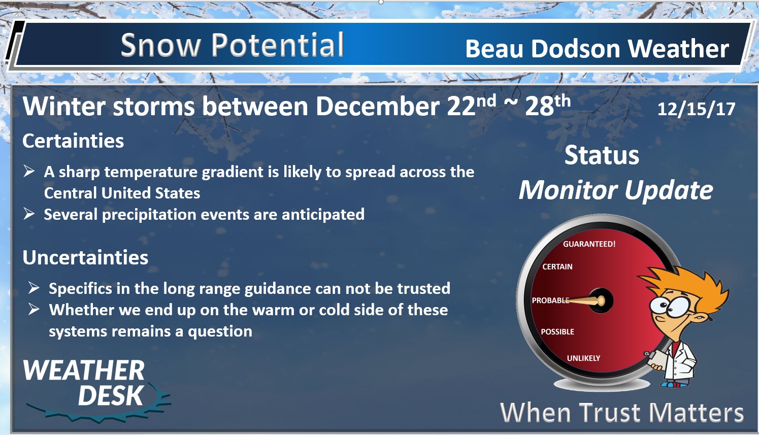
Thursday through next Thursday: At this time, accumulation appears unlikely.
I am monitoring next Thursday night into Christmas week. A few systems could bring wintry weather to the region. Low confidence (too far out).
.

The National Weather Service definition of a severe thunderstorm is one that produces quarter size hail or larger, 58 mph winds or greater, and/or a tornado.
Friday through next Thursday: No severe weather.
.

.
December 15, 2017
Forecast
Dry today and tonight. We will have some a mix of sun and clouds. Temperatures will top out in the forties.
Dry weather will continue into Saturday afternoon across the area.
Saturday is the pick day of the weekend. Temperatures will rise into the fifties. That means above normal temperatures.
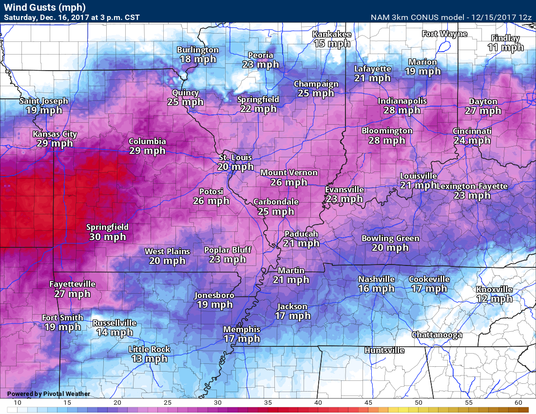
We will have gusty winds on Saturday.
You can expect winds to range from 10 to 20 mph. Gusts above 20 mph are possible.
Gusty winds are possible pretty much all day. Here is the 3 PM wind map.
.
.
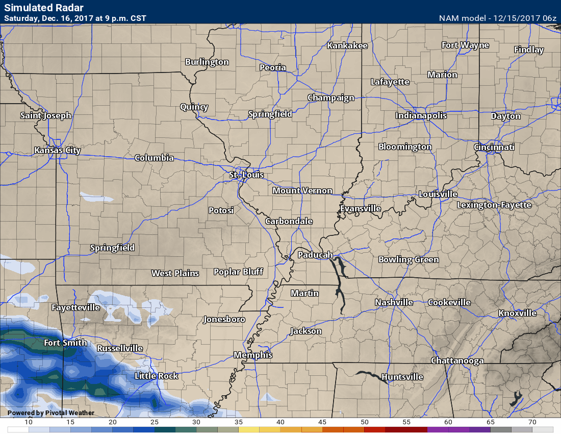
Rain chances rapidly ramp up Saturday night and Sunday.
A system will move into our region from the south and southwest late Saturday night. This system will spread clouds and rain showers into the region. Rainfall totals will mainly range from 0.10″ to 0.25″ over northern parts of southeast Missouri and northern parts of southern Illinois to 0.25″ to 0.50″ across far southeast Missouri, extreme southern Illinois, western Kentucky, and northwest Tennessee.
Severe weather is not anticipated.
Here is the future-cast radar from the NAM model guidance. Time stamp is located on the upper left portion of the graphic.
.
.
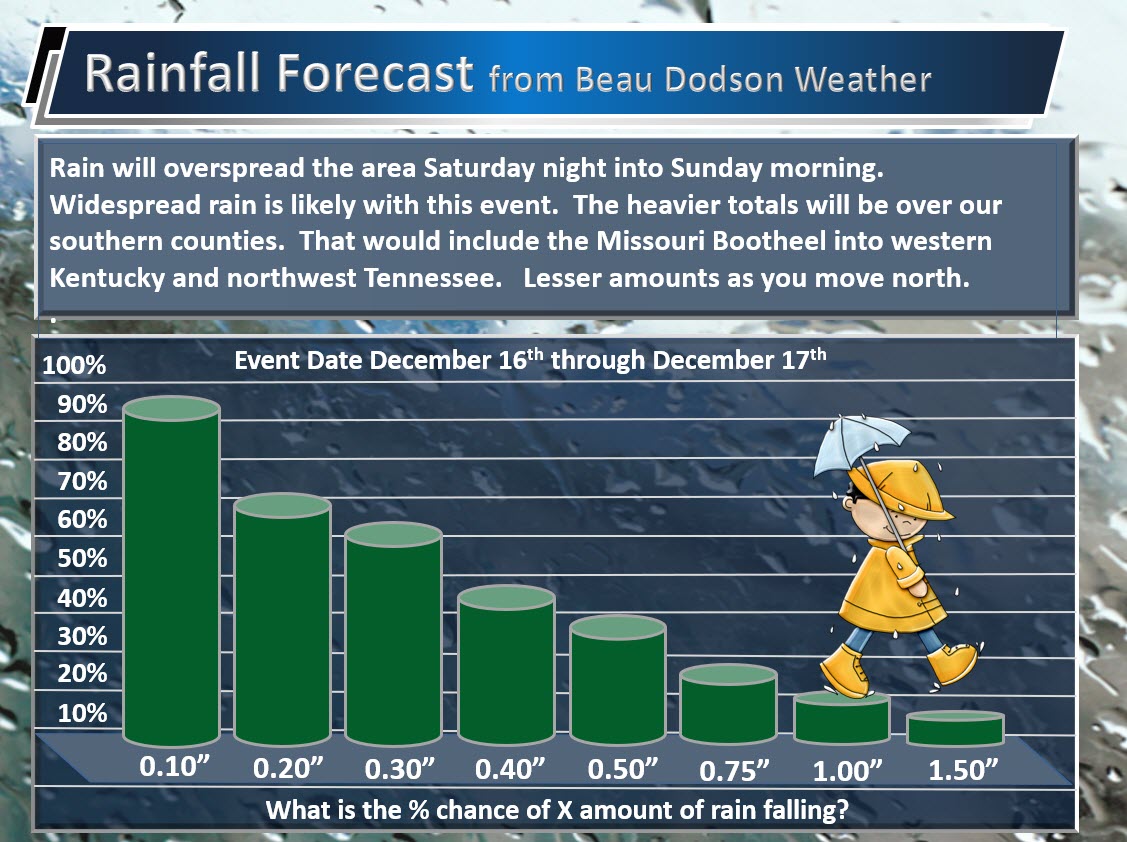
Here is my rainfall forecast for the Saturday night/Sunday event.
.
.
Next Week’s Forecast.
Monday and Tuesday will deliver a mix of sun and clouds. Small rain chances. Milder Monday through Thursday with highs in the 50’s.
I continue to monitor a series of storm systems late next week into the following. This is a classic set-up for precipitation in our region.
If the guidance is correct, then several chances of precipitation will develop starting next late Thursday night or Friday.
This set-up needs to be closely monitored. Historically this type of pattern produces copious amounts of precipitation.
Although I can forecast the pattern, I can’t forecast the specifics. At least not, yet. It is too far out for specifics.
A sharp temperature gradient is forecast to occur across the Central United States late next week into the following. This boundary would set the stage for overrunning precipitation.
Overrunning precipitation is when warm air moves up and over cold air. This produces clouds and precipitation.
It is still too early to know if guidance is correct in sniffing out the potential set-up. Long range models are not all that accurate past a few days during the winter months. The pattern indicates above normal chances of wintry weather late next week into the following.
Remember, potential does not always make reality when it comes to weather.
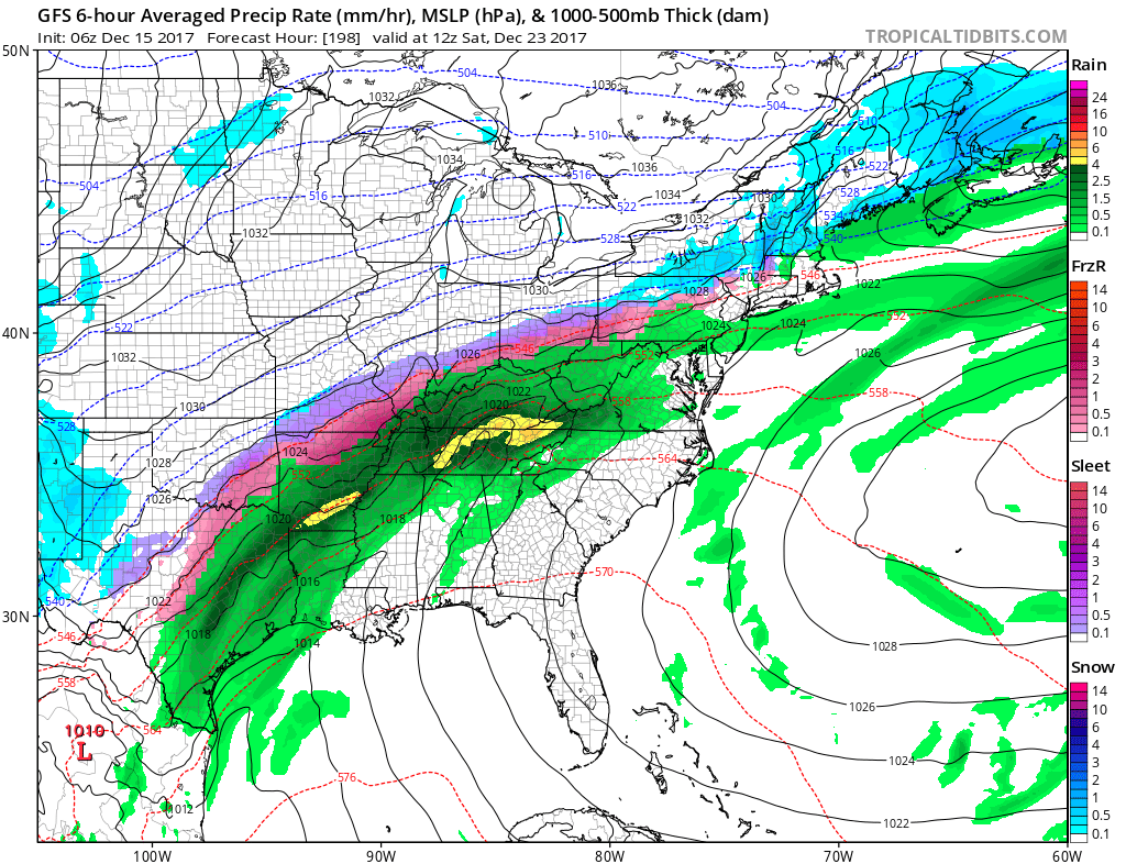
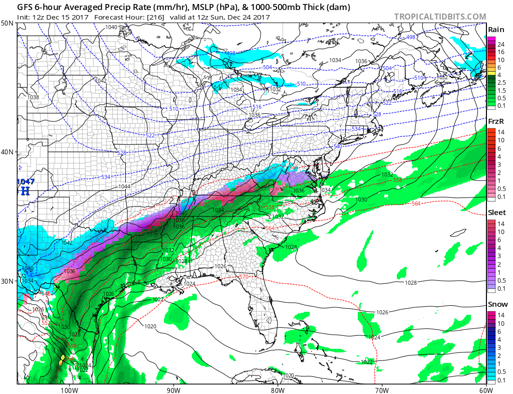
The GFS guidance is showing frozen precipitation in our region as early as next Friday and Saturday.
Here is what the GFS shows.
A frontal boundary will be draped across our region. This will separate the cold air from the warmer air. The boundary will provide the opportunity for overrunning precipitation.
The model has been showing wild swings from one run to the next. It runs four times each day. This is one reason your app forecast changes constantly. Those app’s are based off of the GFS model.
My app is a human forecast. I type the forecast and send it to you. So, when I say your app forecast I am not talking about mine.
This may is for next Friday night and Saturday morning.
Will it verify? Too soon to know that.
.
.
The map above was the Thursday night run of the GFS.
Now, look at this mornings run of the GFS. Storm is south of us. We have a long way to go before we know the details of this potential event.
.
.
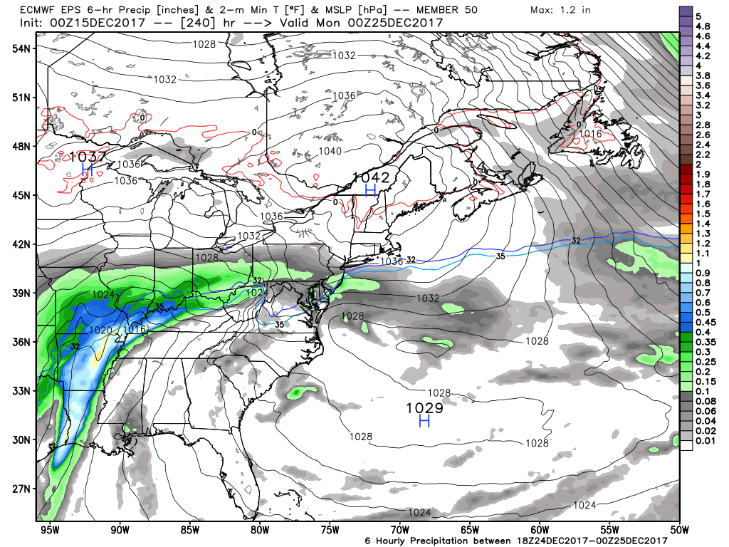
The EC ensemble model guidance shows widespread precipitation, as well. This would be for next Friday, Saturday, and Sunday.
Some of it rain. Some of it wintry mix. The front will determine who ends up with what type of precipitation.
.
.
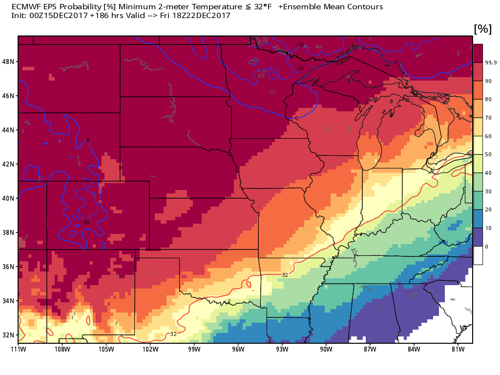
Where will the 32 degree line find itself? That is a good question. Here is the EC model guidance ensemble mean. That thin red line is the 32 degree line. The EC places us right over our region.
North of that line would receive freezing rain, sleet, and snow. South of the line would receive rain. This is assuming there is precipitation in the region. Still early for certainties.
Long way to go to monitor this event.
This is for next Friday into Sunday.
.
.
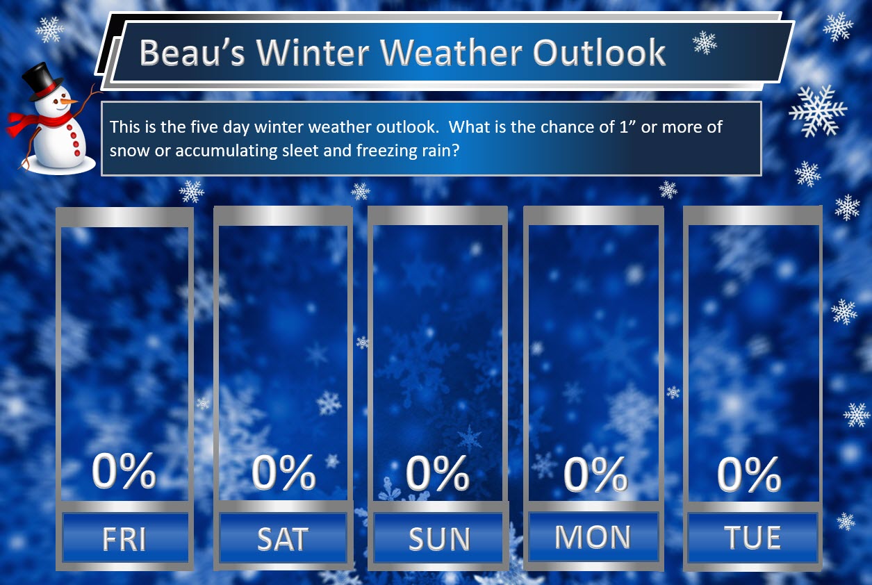
Beau’s Winter Weather Outlook
It is important to remember that this pattern is fluid. There is always going to be lower than normal confidence, during the winter months, for the forecast past day three or four.
.
.
.
Here are my latest snow probability maps for the week ahead.
These graphics show you the % chance of one inch or more of snow and/or accumulating sleet and freezing rain.
.
.
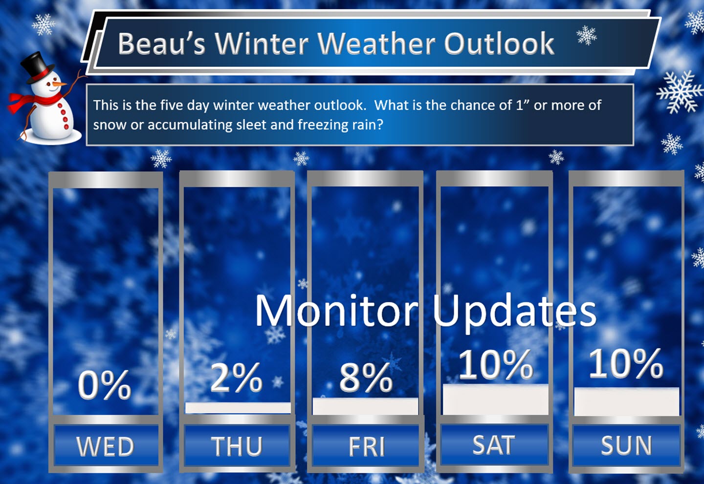
We need to monitor late next week into Christmas week. Model guidance shows a very active pattern that could mean multiple precipitation events. Monitor updates moving forward. Confidence is low (it is in the long range).
I am monitoring next Thursday, Friday, Saturday, and Sunday (then into Christmas week, as well). All types of wintry precipitation will be possible.
If we end up on the warm side of the boundary then precipitation type would be rain. Too soon to know the answer to that question.
Keep in mind, I rarely go above 10% chances past day five. That means 10% is a max number for days six through ten.
.
.
Christmas weekend into Christmas week. Is an active pattern developing?
There is an above normal risk for a storm system(s) between December 22nd and December 28th.
For those of you wanting cold and snow you may be in luck. Several winter storms are being portrayed on model guidance late next week into the following week.
The pattern remains favorable for wintry weather. The question is going to be storm track and the placement of a boundary in or near our region.
This boundary will separate cold air from warmer air.
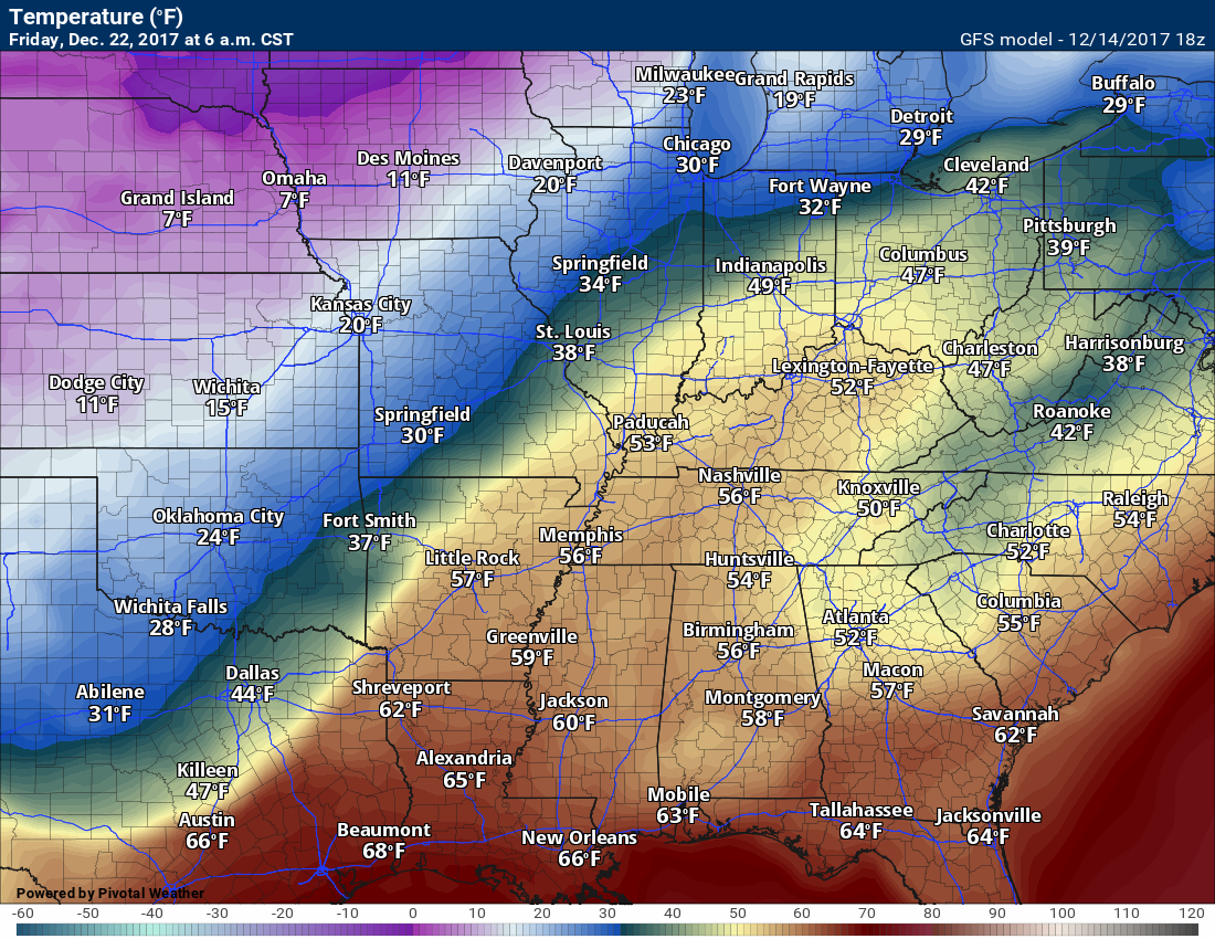
You can see the boundary depicted on this GFS map late next week. When these boundaries occur we typically see widespread precipitation.
This map is next Friday morning. Warm air over our region according to the GFS model guidance. Cold air to our north.
It is too soon to know which side of the boundary we will be on. That is key to precipitation type. Rain? Snow? Wintry mix?
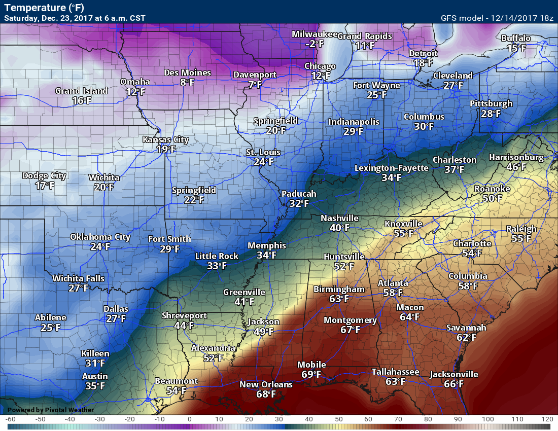
This is the 6 a.m. map for Friday, December 22nd. Notice the sharp boundary. Eleven degrees in Des Moines, Iowa, and 52 degrees in Paducah, Kentucky.
.
.
This next map is for 6 a.m. next Saturday. Notice that temperatures have fallen. Long way to go until we know if these maps will verify.
..
.
Let me show you the GFS model guidance 5 day running averages for temperatures. Normal temperatures are around 47 degrees for highs and 28 degrees for lows.
This first map is for December 15th through the 20th
Notice most of the nation will experience above normal temperatures.
You can see the orange colors. That represents above normal temperatures. We will have a bit of a mild spell ahead of the next potential cold snap.
.

.
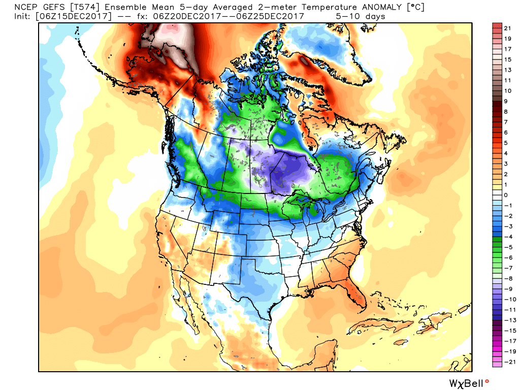
This next map is for December 20th through the 25th. Now you can see the changes. Blue and green colors developing. That represents below normal temperatures.
A strong cold front will push into the United States from the north. This could develop a lot of cold air.
.
.
Finally, let’s look at December 25th through the 29th
Much below normal temperatures across a large chunk of the United States.
.

.


We offer regional radars and local city radars – if a radar does not update then try another one. Occasional browsers need their cache cleared. You may also try restarting your browser. This will usually fix any problems.
During the winter you can track snow and ice by clicking the winterize button on the local city view interactive radars.
You may email me at beaudodson@usawx.com
Interactive Weather Radar Page. Choose the city nearest your location: Click this link
National interactive radar: Click this link.