
December 14, 2017
Your daily forecast into the coming weekend.
.
December 14, 2017
Thursday Forecast Details
Forecast: Quite a few clouds. Chilly temperatures.
Temperatures: MO ~ 38 to 42 IL ~ 36 to 44 KY ~ 38 to 44
Wind chill values: 30 to 40
Accumulating snow or ice: No
Winds: West and northwest at 5 to 10 mph
What impacts are anticipated from the weather? None
My confidence in the forecast verifying: High
Is severe weather expected? No
The NWS defines severe weather as 58 mph wind or great, 1″ hail or larger, and/or tornadoes
Is freezing rain, sleet, or snow expected? No
What is the chance of precipitation? MO ~ 0% IL ~ 0% KY ~ 0%
Coverage of precipitation: None
Should I cancel my outdoor plans? No
.
Thursday Night Forecast Details:
Forecast: Partly cloudy. A slight chance of a flurry.
Temperatures: MO ~ 24 to 28 IL ~ 22 to 26 KY ~ 24 to 28
Wind chill values: 20 to 25
Accumulating snow or ice: No
Winds: North and northwest winds of 0 to 6 mph
What impacts are anticipated from the weather? Most likely none.
My confidence in the forecast verifying: High
Is severe weather expected? No
The NWS defines severe weather as 58 mph wind or great, 1″ hail or larger, and/or tornadoes
Is freezing rain, sleet, or snow expected? Small chance of a flurry
What is the chance of precipitation? MO ~ 20% IL ~ 20% KY ~ 20%
Coverage of precipitation: Isolated
Should I cancel my outdoor plans: No
.
December 15, 2017
Friday Forecast Details
Forecast: Morning clouds. Becoming partly sunny. Chilly.
Temperatures: MO ~ 44 to 46 IL ~ 40 to 45 KY ~ 42 to 46
Wind chill values: 35 to 40
Accumulating snow or ice: No
Winds: West and northwest at 5 to 10 mph with gusts to 15 mph
What impacts are anticipated from the weather? None
My confidence in the forecast verifying: High
Is severe weather expected? No
The NWS defines severe weather as 58 mph wind or great, 1″ hail or larger, and/or tornadoes
Is freezing rain, sleet, or snow expected? No
What is the chance of precipitation? MO ~ 10% IL ~ 10% KY ~ 10%
Coverage of precipitation:Most likely none
Should I cancel my outdoor plans? No
.
Friday Night Forecast Details:
Forecast: Mostly clear. Chilly temperatures.
Temperatures: MO ~ 25 to 30 IL ~ 25 to 30 KY ~ 28 to 34
Wind chill values: 20’s
Accumulating snow or ice: No
Winds: South and southwest winds 4 to 8 mph
What impacts are anticipated from the weather? None
My confidence in the forecast verifying: High
Is severe weather expected? No
The NWS defines severe weather as 58 mph wind or great, 1″ hail or larger, and/or tornadoes
Is freezing rain, sleet, or snow expected? None
What is the chance of precipitation? MO ~ 0% IL ~ 0% KY ~ 0%
Coverage of precipitation: None
Should I cancel my outdoor plans: No
.
December 16, 2017
Saturday Forecast Details
Forecast: Mostly sunny. Warmer. Clouds may increase during the afternoon.
Temperatures: MO ~ 52 to 56 IL ~ 52 to 55 KY ~ 52 to 56
Wind chill values: N/A
Accumulating snow or ice: No
Winds: South and southwest winds 8 to 16 mph with gusts above 25 mph
What impacts are anticipated from the weather? None
My confidence in the forecast verifying: High
Is severe weather expected? No
The NWS defines severe weather as 58 mph wind or great, 1″ hail or larger, and/or tornadoes
Is freezing rain, sleet, or snow expected? No
What is the chance of precipitation? MO ~ 0% IL ~ 0% KY ~ 0%
Coverage of precipitation: None
Should I cancel my outdoor plans? No
.
Saturday Night Forecast Details:
Forecast: Becoming cloudy. Breezy. Showers increasing from the south and west.
Temperatures: MO ~ 35 to 40 IL ~ 35 to 40 KY ~ 35 to 40
Wind chill values: 30 to 40
Accumulating snow or ice: No
Winds: South and southwest winds 7 to 14 mph with gusts to 25 mph
What impacts are anticipated from the weather? Wet roadways
My confidence in the forecast verifying: High
Is severe weather expected? No
The NWS defines severe weather as 58 mph wind or great, 1″ hail or larger, and/or tornadoes
Is freezing rain, sleet, or snow expected? None
What is the chance of precipitation? MO ~ 70% IL ~ 60% KY ~ 70%
Coverage of precipitation:Increasing coverage from the south and west.
Should I cancel my outdoor plans: No
.
December 17, 2017
Sunday Forecast Details
Forecast: Mostly cloudy. Widespread rain is anticipated. Greatest coverage before 1 pm. Rain may decrease during the afternoon.
Temperatures: MO ~ 44 to 48 IL ~ 44 to 48 KY ~ 45 to 48
Wind chill values: N/A
Accumulating snow or ice: No
Winds: Southwest becoming west and northwest at 6 to 12 mph with gusts to 18 mph
What impacts are anticipated from the weather? Wet roadways
My confidence in the forecast verifying: High
Is severe weather expected? No
The NWS defines severe weather as 58 mph wind or great, 1″ hail or larger, and/or tornadoes
Is freezing rain, sleet, or snow expected? No
What is the chance of precipitation? MO ~ 80% IL ~ 70% KY ~ 80%
Coverage of precipitation: Widespread first half of the day with decreasing coverage as we move into the afternoon
Should I cancel my outdoor plans? Have a plan B
.
Sunday Night Forecast Details:
Forecast: Partly cloudy. A slight chance of rain showers or flurries. Most of the precipitation should have ended.
Temperatures: MO ~ 34 to 38 IL ~ 34 to 38 KY ~ 34 to 38
Wind chill values: 20’s and 30’s
Accumulating snow or ice: No
Winds: West and northwest winds 5 to 10 mph with gusts to 15 mph.
What impacts are anticipated from the weather? Wet roadways
My confidence in the forecast verifying: Medium
Is severe weather expected? No
The NWS defines severe weather as 58 mph wind or great, 1″ hail or larger, and/or tornadoes
Is freezing rain, sleet, or snow expected? None
What is the chance of precipitation? MO ~ 20% IL ~ 30% KY ~ 30%
Coverage of precipitation: Ending
Should I cancel my outdoor plans: Monitor updates
.
December 18, 2017
Monday Forecast Details
Forecast: Partly cloudy. A slight chance of a shower.
Temperatures: MO ~ 52 to 58 IL ~ 52 to 58 KY ~ 52 to 58
Wind chill values: N/A
Accumulating snow or ice: No
Winds: West and southwest winds 5 to 10 mph
What impacts are anticipated from the weather? Probably none. Small chance of a wet roadway
My confidence in the forecast verifying: Medium
Is severe weather expected? No
The NWS defines severe weather as 58 mph wind or great, 1″ hail or larger, and/or tornadoes
Is freezing rain, sleet, or snow expected? No
What is the chance of precipitation? MO ~ 10% IL ~ 10% KY ~ 10%
Coverage of precipitation: Most likely none. Isolated shower possible.
Should I cancel my outdoor plans? No
.
Monday Night Forecast Details:
Forecast: Partly cloudy. Increasing clouds late.
Temperatures: MO ~ 30 to 35 IL ~ 30 to 35 KY ~ 30 to 35
Wind chill values: 25 to 35
Accumulating snow or ice: No
Winds: Southwest winds at 5 to 10 mph
What impacts are anticipated from the weather? Most likely none, but I will monitor a slight chance of precipitation
My confidence in the forecast verifying: LOW
Is severe weather expected? No
The NWS defines severe weather as 58 mph wind or great, 1″ hail or larger, and/or tornadoes
Is freezing rain, sleet, or snow expected? None
What is the chance of precipitation? MO ~ 10% IL ~ 10% KY ~ 10%
Coverage of precipitation: None to isolated
Should I cancel my outdoor plans: No
.
December 19, 2017
Tuesday Forecast Details
Forecast: Partly cloudy. Warmer. A slight chance of a shower.
Temperatures: MO ~ 53 to 56 IL ~ 53 to 56 KY ~ 53 to 56
Wind chill values: N/A
Accumulating snow or ice: No
Winds: Southwest 6 to 12 mph
What impacts are anticipated from the weather? Perhaps wet roadways.
My confidence in the forecast verifying: LOW
Is severe weather expected? No
The NWS defines severe weather as 58 mph wind or great, 1″ hail or larger, and/or tornadoes
Is freezing rain, sleet, or snow expected? No
What is the chance of precipitation? MO ~ 20% IL ~ 20% KY ~ 20%
Coverage of precipitation: Isolated
Should I cancel my outdoor plans? No
.
Tuesday Night Forecast Details:
Forecast: Some clouds. Cool.
Temperatures: MO ~ 30 to 35 IL ~ 30 to 35 KY ~ 30 to 35
Wind chill values: 25 to 35
Accumulating snow or ice: No
Winds: West winds at 5 to 10 mph
What impacts are anticipated from the weather? Most likely none
My confidence in the forecast verifying: LOW
Is severe weather expected? No
The NWS defines severe weather as 58 mph wind or great, 1″ hail or larger, and/or tornadoes
Is freezing rain, sleet, or snow expected? None
What is the chance of precipitation? MO ~ 10% IL ~ 10% KY ~ 10%
Coverage of precipitation:
Should I cancel my outdoor plans: No
.

.
Thursday through next Thursday: At this time, accumulation appears unlikely.
.

The National Weather Service definition of a severe thunderstorm is one that produces quarter size hail or larger, 58 mph winds or greater, and/or a tornado.
Thursday through next Thursday: No severe weather.
.

.
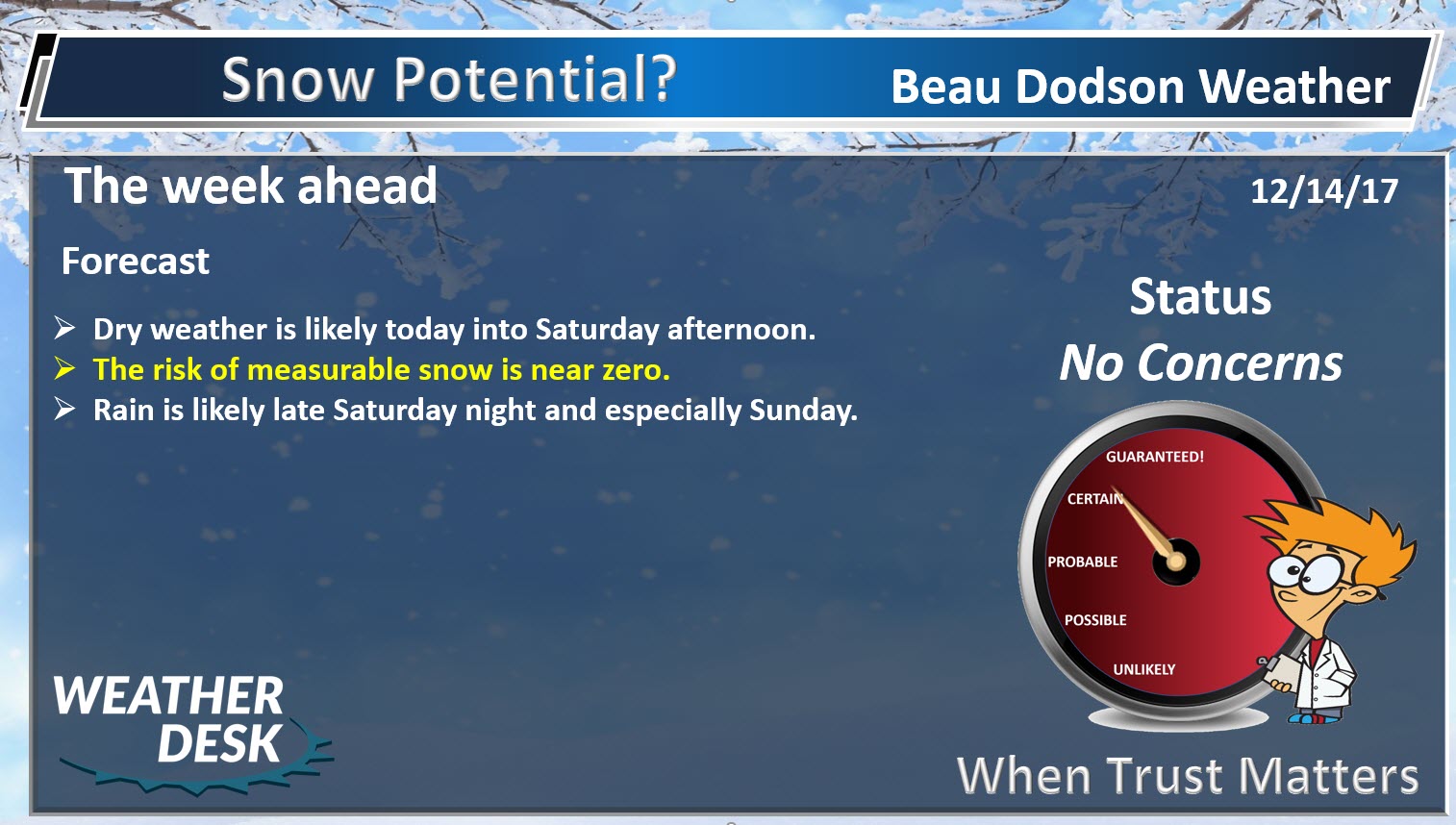
A short update today. Today is a travel day.
Dry weather will continue into Saturday afternoon across the area.
Temperatures today will be held down by clouds. You can expect highs in the upper 30’s to lower 40’s. Highs on Friday will rise into the 40’s. A bit warmer on Saturday with 50’s anticipated. Gusty winds are likely on Saturday.
Saturday is the pick day of the weekend.
Rain chances rapidly ramp up Saturday night and Sunday.
A system will move into our region from the south and southwest late Saturday night. This system will spread clouds and rain showers into the region. Rainfall totals will mainly range from 0.10″ to 0.25″ over northern parts of southeast Missouri and northern parts of southern Illinois to 0.25″ to 0.50″ across far southeast Missouri, extreme southern Illinois, western Kentucky, and northwest Tennessee.
Severe weather is not anticipated.
I continue to monitor a series of storm systems late next week into the following. This is a classic set-up for precipitation in our region.
If the guidance is correct, then several chances of precipitation will develop starting next Friday.
This set-up needs to be closely monitored. Historically this type of pattern produces copious amounts of precipitation.
A sharp temperature gradient is forecast to occur across the Central United States late next week into the following. This boundary would set the stage for overrunning precipitation.
Overrunning precipitation is when warm air moves up and over cold air. This produces clouds and precipitation.
It is still too early to know if guidance is correct in sniffing out the potential set-up. Long range models are not all that accurate past a few days during the winter months.
.
Beau’s Winter Weather Outlook
.
.
.
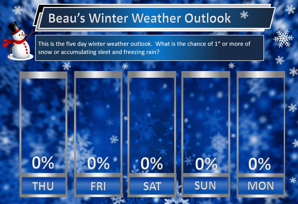
Here are my latest snow probability maps for the week ahead.
These graphics show you the % chance of one inch or more of snow and/or accumulating sleet and freezing rain.
.
.
We need to monitor late next week into Christmas week. Model guidance shows a very active pattern that could mean multiple precipitation events. Monitor updates moving forward. Confidence is low (it is in the long range).
I am monitoring next Friday, Saturday, and Sunday (then into Christmas week, as well).
If we end up on the warm side of the boundary then rain will fall. Too soon to know the answer to that question.
.

.
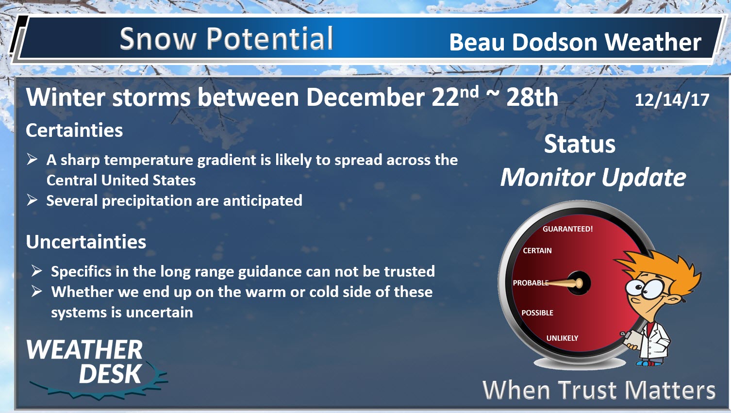
Christmas weekend into Christmas week. Is an active pattern developing?
There is an above normal risk for a storm system(s) between December 22nd and December 28th.
For those of you wanting cold and snow you may be in luck. Several winter storms are being portrayed on model guidance late next week into the following week.
The pattern remains favorable for wintry weather. The question is going to be storm track and the placement of a boundary in or near our region.
This boundary will separate cold air from warmer air.
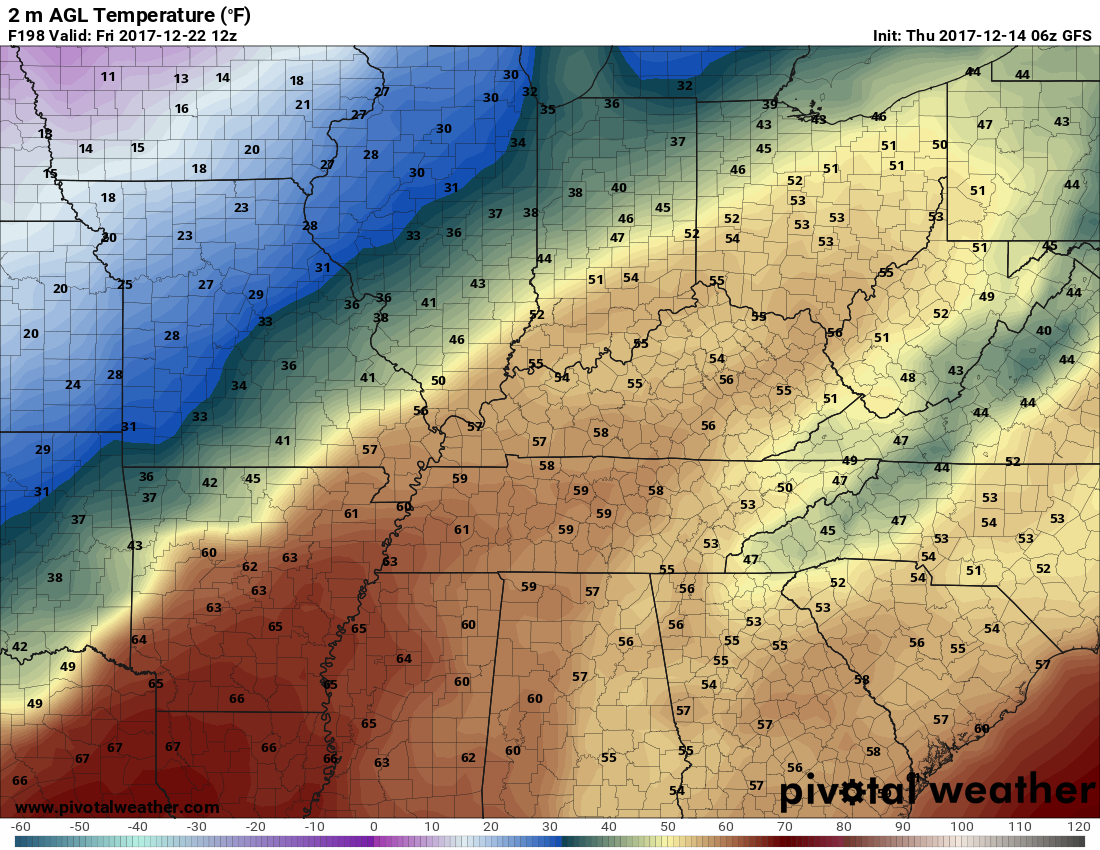
You can see the boundary depicted on this GFS map late next week. When these boundaries occur we typically see widespread precipitation.
This map is next Friday morning. Warm air over our region according to the GFS model guidance. Cold air to our north.
It is too soon to know which side of the boundary we will be on. That is key to precipitation type. Rain? Snow? Wintry mix?
.
.


We offer regional radars and local city radars – if a radar does not update then try another one. Occasional browsers need their cache cleared. You may also try restarting your browser. This will usually fix any problems.
During the winter you can track snow and ice by clicking the winterize button on the local city view interactive radars.
You may email me at beaudodson@usawx.com
Interactive Weather Radar Page. Choose the city nearest your location: Click this link
National interactive radar: Click this link.