
.
Beau’s Daily forecast
.
Your daily forecast into the coming weekend.
.
December 11, 2017
Monday Night Forecast Details:
Forecast: Partly to mostly cloudy. Breezy. Cold wind chills. Isolated flurries possible late over southeast Illinois and northwest Kentucky.
Temperatures: MO ~ 25 to 32 IL ~ 25 to 32 KY ~ 26 to 32
Wind chill values: 16 to 25 degrees
Accumulating snow or ice: Unlikely
Winds: Northwest winds 8 to 16 mph with gusts to 25 mph
What impacts are anticipated from the weather? Most likely none
My confidence in the forecast verifying: High
Is severe weather expected? No
The NWS defines severe weather as 58 mph wind or great, 1″ hail or larger, and/or tornadoes
Is freezing rain, sleet, or snow expected? None
What is the chance of precipitation? MO ~ 10% IL ~ 20% KY ~ 20%
Coverage of precipitation: Isolated after midnight over southeast Illinois and northwest Kentucky.
Should I cancel my outdoor plans: No
.
December 12, 2017
Tuesday Forecast Details
Forecast: Partly sunny. Breezy. A chance of morning flurries. Colder.
Temperatures: MO ~ 34 to 38 IL ~ 34 to 38 KY ~ 34 to 38
Wind chill values: 15 to 25
Accumulating snow or ice: No
Winds: Northwest 6 to 12 mph with gusts to 25 mph
What impacts are anticipated from the weather? None
My confidence in the forecast verifying: High
Is severe weather expected? No
The NWS defines severe weather as 58 mph wind or great, 1″ hail or larger, and/or tornadoes
Is freezing rain, sleet, or snow expected? No
What is the chance of precipitation? MO ~ 10% IL ~ 10% KY ~ 10%
Coverage of precipitation: None to isolated
Should I cancel my outdoor plans? No
.
Tuesday Night Forecast Details:
Forecast: Mostly clear. Cold.
Temperatures: MO ~ 20 to 25 IL ~ 20 to 25 KY ~ 23 to 26
Wind chill values: 16 to 24 degrees
Accumulating snow or ice: No
Winds: Northwest winds 5 to 10 mph with gusts to 14 mph
What impacts are anticipated from the weather? None
My confidence in the forecast verifying: High
Is severe weather expected? No
The NWS defines severe weather as 58 mph wind or great, 1″ hail or larger, and/or tornadoes
Is freezing rain, sleet, or snow expected? None
What is the chance of precipitation? MO ~ 0% IL ~ 0% KY ~ 0%
Coverage of precipitation: None
Should I cancel my outdoor plans: No
.
December 13, 2017
Wednesday Forecast Details
Forecast: Mostly sunny. Some passing clouds. Breezy. Cool temperatures.
Temperatures: MO ~ 46 to 50 IL ~ 44 to 48 KY ~ 45 to 50
Wind chill values: N/A
Accumulating snow or ice: No
Winds: South and southwest winds at 10 to 20 mph
What impacts are anticipated from the weather? None
My confidence in the forecast verifying: High
Is severe weather expected? No
The NWS defines severe weather as 58 mph wind or great, 1″ hail or larger, and/or tornadoes
Is freezing rain, sleet, or snow expected? No
What is the chance of precipitation? MO ~ 0% IL ~ 0% KY ~ 0%
Coverage of precipitation: None
Should I cancel my outdoor plans? No
.
Wednesday Night Forecast Details:
Forecast: A few clouds. Chilly.
Temperatures: MO ~ 28 to 33 IL ~ 26 to 32 KY ~ 28 to 34
Wind chill values: 25 to 35 degrees
Accumulating snow or ice: No
Winds: West and northwest winds 7 to 14 mph. Winds may become variable in direction.
What impacts are anticipated from the weather? Most likely none
My confidence in the forecast verifying: High
Is severe weather expected? No
The NWS defines severe weather as 58 mph wind or great, 1″ hail or larger, and/or tornadoes
Is freezing rain, sleet, or snow expected? None
What is the chance of precipitation? MO ~ 10% IL ~ 10% KY ~ 10%
Coverage of precipitation: None to isolated
Should I cancel my outdoor plans: No
.
December 14, 2017
Thursday Forecast Details
Forecast: Quite a few clouds. Chilly temperatures.
Temperatures: MO ~ 40 to 45 IL ~ 38 to 44 KY ~ 42 to 46
Wind chill values: N/A
Accumulating snow or ice: No
Winds: West and northwest at 5 to 10 mph
What impacts are anticipated from the weather? None
My confidence in the forecast verifying: High
Is severe weather expected? No
The NWS defines severe weather as 58 mph wind or great, 1″ hail or larger, and/or tornadoes
Is freezing rain, sleet, or snow expected? No
What is the chance of precipitation? MO ~ 0% IL ~ 0% KY ~ 0%
Coverage of precipitation: None
Should I cancel my outdoor plans? No
.
Thursday Night Forecast Details:
Forecast: Partly cloudy. Snow showers or rain showers possible.
Temperatures: MO ~ 24 to 28 IL ~ 24 to 28 KY ~ 24 to 28
Wind chill values: 20 to 25
Accumulating snow or ice: No
Winds: Northwest winds 5 to 10 mph
What impacts are anticipated from the weather? Perhaps wet roadways.
My confidence in the forecast verifying: LOW
Is severe weather expected? No
The NWS defines severe weather as 58 mph wind or great, 1″ hail or larger, and/or tornadoes
Is freezing rain, sleet, or snow expected? None
What is the chance of precipitation? MO ~ 30% IL ~ 30% KY ~ 30%
Coverage of precipitation: Isolated to perhaps scattered
Should I cancel my outdoor plans: No
.
December 15, 2017
Friday Forecast Details
Forecast: Morning clouds. A chance of a shower or snow shower before 10 am.
Temperatures: MO ~ 42 to 46 IL ~ 40 to 45 KY ~ 44 to 48
Wind chill values: N/A
Accumulating snow or ice: Unlikely
Winds: West and northwest at 5 to 10 mph with gusts to 15 mph
What impacts are anticipated from the weather? Perhaps wet roadways.
My confidence in the forecast verifying: LOW
Is severe weather expected? No
The NWS defines severe weather as 58 mph wind or great, 1″ hail or larger, and/or tornadoes
Is freezing rain, sleet, or snow expected? Monitor updates
What is the chance of precipitation? MO ~ 20% IL ~ 20% KY ~ 20%
Coverage of precipitation: Isolated to scattered
Should I cancel my outdoor plans? No
.
Friday Night Forecast Details:
Forecast: Mostly clear.
Temperatures: MO ~ 25 to 30 IL ~ 25 to 30 KY ~ 28 to 34
Wind chill values: 20’s
Accumulating snow or ice: No
Winds: South and southwest winds 4 to 8 mph
What impacts are anticipated from the weather? None
My confidence in the forecast verifying: Medium
Is severe weather expected? No
The NWS defines severe weather as 58 mph wind or great, 1″ hail or larger, and/or tornadoes
Is freezing rain, sleet, or snow expected? None
What is the chance of precipitation? MO ~ 0% IL ~ 0% KY ~ 0%
Coverage of precipitation: None
Should I cancel my outdoor plans: No
.
December 16, 2017
Saturday Forecast Details
Forecast: Mostly sunny. Warmer.
Temperatures: MO ~ 52 to 56 IL ~ 50 to 55 KY ~ 52 to 56
Wind chill values: N/A
Accumulating snow or ice: No
Winds: South and southwest winds 8 to 16 mph
What impacts are anticipated from the weather? None
My confidence in the forecast verifying: Medium
Is severe weather expected? No
The NWS defines severe weather as 58 mph wind or great, 1″ hail or larger, and/or tornadoes
Is freezing rain, sleet, or snow expected? No
What is the chance of precipitation? MO ~ 0% IL ~ 0% KY ~ 0%
Coverage of precipitation: None
Should I cancel my outdoor plans? No
.
Saturday Night Forecast Details:
Forecast: Becoming cloudy. Breezy. A slight chance of a shower.
Temperatures: MO ~ 35 to 40 IL ~ 35 to 40 KY ~ 35 to 40
Wind chill values: 30 to 40
Accumulating snow or ice: No
Winds: South and southwest winds 7 to 14 mph with gusts to 25 mph
What impacts are anticipated from the weather? Wet roadways
My confidence in the forecast verifying: Medium
Is severe weather expected? No
The NWS defines severe weather as 58 mph wind or great, 1″ hail or larger, and/or tornadoes
Is freezing rain, sleet, or snow expected? None
What is the chance of precipitation? MO ~ 10% IL ~ 10% KY ~ 10%
Coverage of precipitation: Isolated
Should I cancel my outdoor plans: No
.
December 17, 2017
Sunday Forecast Details
Forecast: Mostly cloudy. Showers possible.
Temperatures: MO ~ 54 to 58 IL ~ 54 to 58 KY ~ 54 to 58
Wind chill values: N/A
Accumulating snow or ice: No
Winds: Southwest becoming west and northwest at 6 to 12 mph with gusts to 18 mph
What impacts are anticipated from the weather? Wet roadways
My confidence in the forecast verifying: LOW
Is severe weather expected? No
The NWS defines severe weather as 58 mph wind or great, 1″ hail or larger, and/or tornadoes
Is freezing rain, sleet, or snow expected? No
What is the chance of precipitation? MO ~ 30% IL ~ 40% KY ~ 40%
Coverage of precipitation: Scattered
Should I cancel my outdoor plans? Monitor updates
.
Sunday Night Forecast Details:
Forecast: Partly cloudy. Snow or rain showers possible.
Temperatures: MO ~ 30 to 35 IL ~ 30 to 35 KY ~ 30 to 35
Wind chill values: 20’s and 30’s
Accumulating snow or ice: No
Winds: West and northwest winds 5 to 10 mph with gusts to 15 mph
What impacts are anticipated from the weather?
My confidence in the forecast verifying: LOW
Is severe weather expected? No
The NWS defines severe weather as 58 mph wind or great, 1″ hail or larger, and/or tornadoes
Is freezing rain, sleet, or snow expected? None
What is the chance of precipitation? MO ~ 20% IL ~ 20% KY ~ 20%
Coverage of precipitation: Scattered
Should I cancel my outdoor plans: Monitor updates
.
December 18, 2017
Monday Forecast Details
Forecast: Mostly cloudy. A shower possible.
Temperatures: MO ~ 40 to 45 IL ~ 40 to 45 KY ~ 40 to 45
Wind chill values: N/A
Accumulating snow or ice: No
Winds:Northwest winds at 5 to 10 mph with gusts to 15 mph
What impacts are anticipated from the weather? Wet roadways
My confidence in the forecast verifying: LOW
Is severe weather expected? No
The NWS defines severe weather as 58 mph wind or great, 1″ hail or larger, and/or tornadoes
Is freezing rain, sleet, or snow expected? No
What is the chance of precipitation? MO ~ 30% IL ~ 40% KY ~ 40%
Coverage of precipitation: Scattered
Should I cancel my outdoor plans? Monitor updates
.
Monday Night Forecast Details:
Forecast: Decreasing clouds.
Temperatures: MO ~ 30 to 35 IL ~ 30 to 35 KY ~ 30 to 35
Wind chill values: 20’s and 30’s
Accumulating snow or ice: No
Winds: Northwest winds at 5 to 10 mph
What impacts are anticipated from the weather? None
My confidence in the forecast verifying: LOW
Is severe weather expected? No
The NWS defines severe weather as 58 mph wind or great, 1″ hail or larger, and/or tornadoes
Is freezing rain, sleet, or snow expected? None
What is the chance of precipitation? MO ~ 10% IL ~ 10% KY ~ 10%
Coverage of precipitation:
Should I cancel my outdoor plans:
.

.
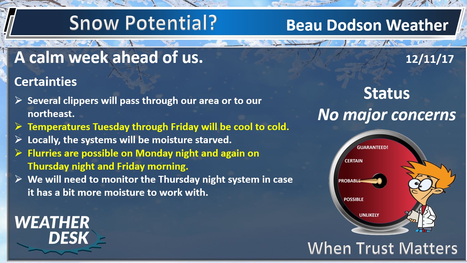
Monday night through Saturday: Flurries are possible on Monday night and early Tuesday morning. No accumulation.
I can’t rule out snow showers with another front around Thursday/Thursday night.
I am also monitoring Sunday night.
.

The National Weather Service definition of a severe thunderstorm is one that produces quarter size hail or larger, 58 mph winds or greater, and/or a tornado.
Monday night through Saturday: No severe weather.
.

.
A fairly calm week ahead of us. The weather might become a bit more active as we move into next week.
We will have a series of clippers pass to our northeast over the coming days. Clippers are fast moving systems that move out of Canada and typically travel southeast. Occasionally, they can bring snow into our local area.
Here they are
One on Monday night and Tuesday
.
.
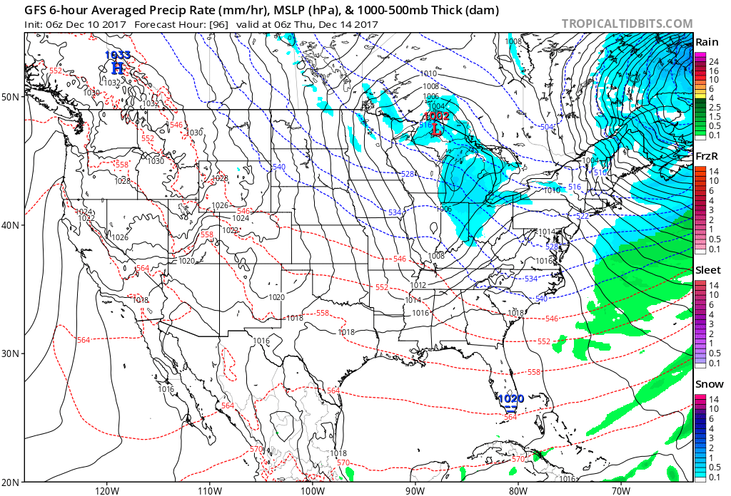
Another one on Wednesday night and Thursday
.
.
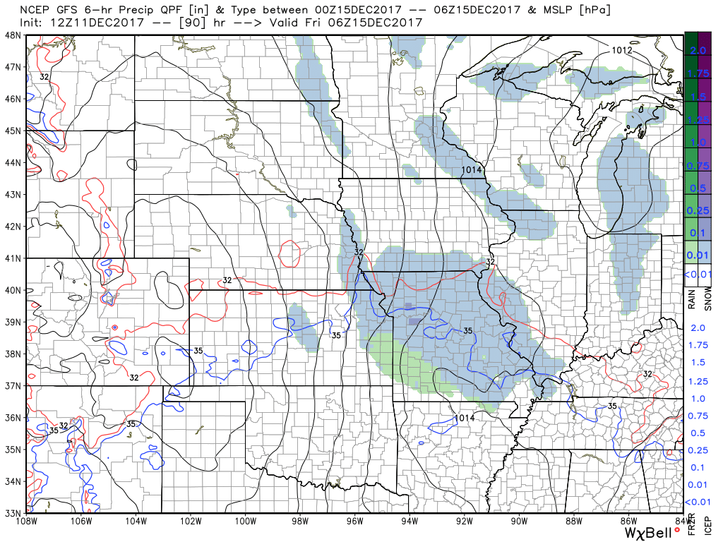
Another one on Thursday night
.
.
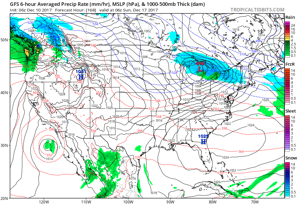
Another one on Saturday
.
.
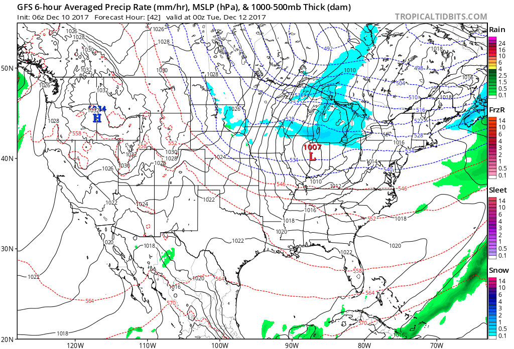
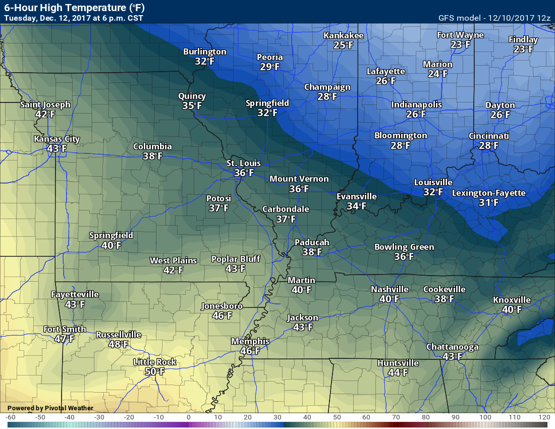
Temperatures on Monday peaked in the middle and upper 50’s. Well above normal. Colder air is already on the way.
A cold front will move through the region later tonight into Tuesday morning. Some clouds and flurries may accompany the front. Nothing significant.
Colder temperatures will follow the frontal passage.
Here are the Tuesday afternoon temperatures. Several degrees colder than today.
.
.
Chilly temperatures will last through Friday. You can expect daily highs in the 40’s. Overnight lows will mostly be in the 20’s.
Temperatures might rebound into the 50’s by Saturday.
I will keep an eye on the Thursday night/Friday morning system. It might have a bit more moisture to work with. Low confidence.
Drought conditions will worsen for southeast Missouri. Little or no measurable rainfall/snowfall is expected through Saturday.
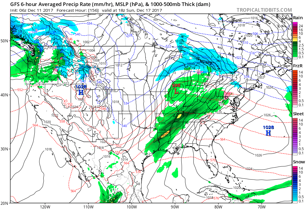
A precipitation event is possible on Sunday and Monday of next week. Right now the guidance indicates that it will be warm enough for rain. I should note, however, that data on this is mixed. Some models shower no rain or snow, some show all rain, some show rain and snow.
You can see the depiction of that system on the map below. The GFS shows an area of low pressure over northern Illinois. There is a cold front trailing into our local area. The green represents rain showers and perhaps thunderstorms along the front.
.
.
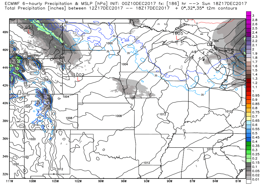
The EC guidance, during the same time frame, shows no system. I will monitor the trends in the guidance over the coming days and update accordingly. Remember, models are for guidance. They are not for determining the forecast.
Here is the EC weather map (below).
.
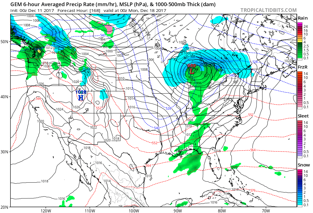
Finally, here is the Canadian model guidance. It shows a system, but it is moisture starved.
I would imagine the truth is somewhere in between the GFS and EC guidance. A cold front will move through the region with some showers. How widespread the rain will be is questionable.
.
. .
.
.
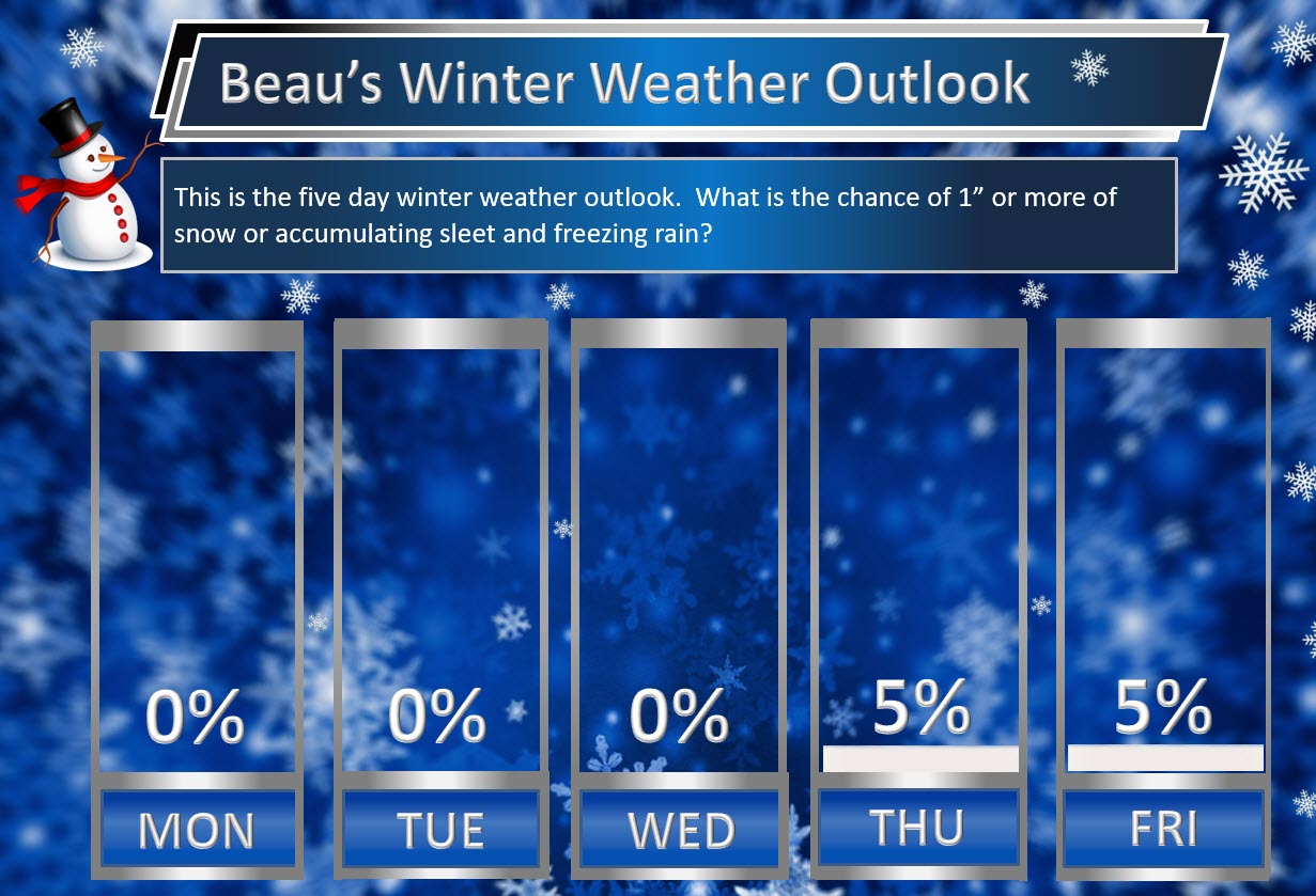
Beau’s Winter Weather Outlook
.
.
Here is my latest snow probability map for the week ahead.
These graphics show you the % chance of one inch or more of snow and/or accumulating sleet and freezing rain.
A few flurries possible Monday night and Tuesday morning. The chance of one inch or more of snow is zero.
I am monitoring Thursday night and Friday morning for snow showers.
.
.

.
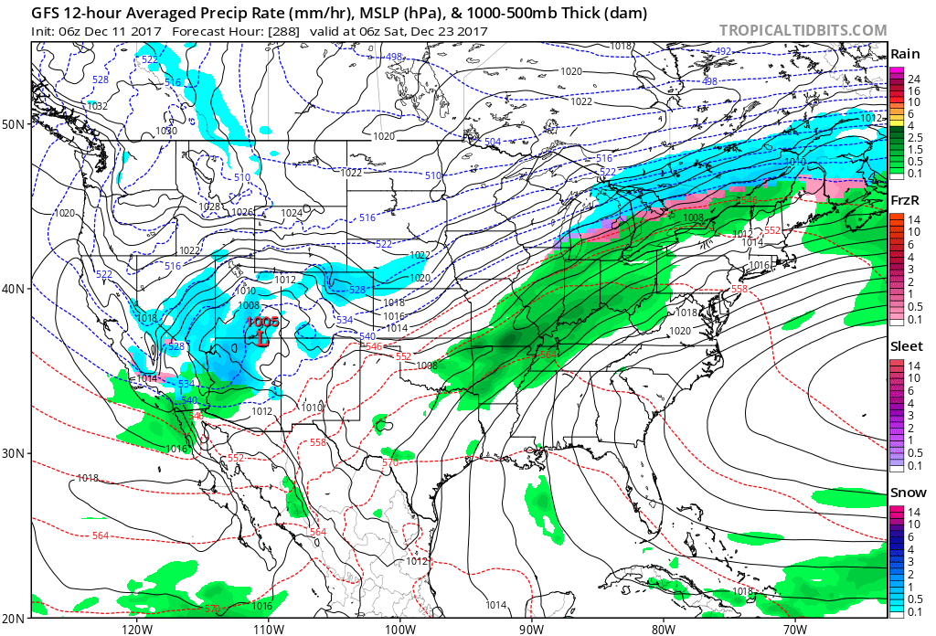
I am closely monitoring a system around the 23rd through the 26th. Confidence is low, because it is so far out in time. Models don’t handle winter forecasts all that great two or three days out.
Models are showing precipitation in our region during this time frame. Whether cold air will be in place is the question. Both the GFS and EC guidance indicate the potential for precipitation.
Here is the GFS for the 23rd. You can see green in our region. That would be rain. Again, it is too early to even know if there will be a system. I am just showing you the GFS model guidance.
.
.
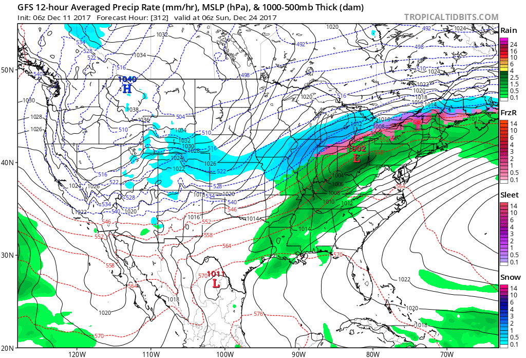
This next image is for December 24th. The GFS is showing heavy rain in our region. Snow to our north. Again, just this models take on the setup. Yesterday this same model was showing heavy snow in our region.
.
.
This next map is for Christmas Day. This particular run of the GFS (it runs four times each day) is showing snow.
.

.
So what does all of this mean? Not much.
It means we have a possible precipitation event in the long range that may or may not actually verify. There could be cold air in place in or near our region for the precipitation to interact with.
It is just too soon to know if we will have snow or rain on or around Christmas.
I will track the potential and update you over the coming days.
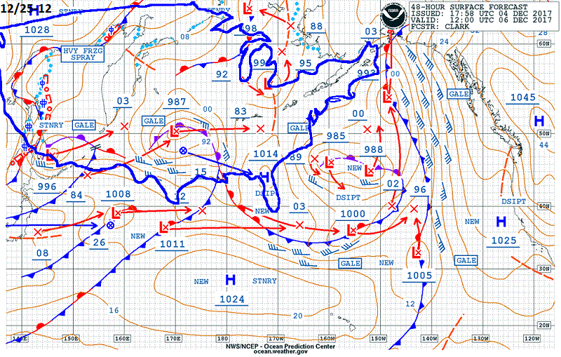
I did notice the BSR indicates a possible system around the 25th and 26th
Here is an explanation of the BSR. Click here for that
In a nutshell
The Bering Sea Rule was a pattern that was recognized back in 2011/2012. If there are significant storm systems in the Bering Sea, that within 3 weeks of those storms we saw storms for the middle and eastern USA. This is not always true, but the rule does have a decent track record.
The map below is the BSR for around Christmas. An area of low pressure in Oklahoma and Texas. A warm front near our region. Precipitation in our region, as well.
.
.


We offer regional radars and local city radars – if a radar does not update then try another one. Occasional browsers need their cache cleared. You may also try restarting your browser. This will usually fix any problems.
During the winter you can track snow and ice by clicking the winterize button on the local city view interactive radars.
You may email me at beaudodson@usawx.com
Interactive Weather Radar Page. Choose the city nearest your location: Click this link
National interactive radar: Click this link.