
WeatherTalk monthly operating costs can top $2000.00. Your $5 subscription helps pay for those costs. I work for you.
The $5 will allow you to register up to seven phones!
For $5 a month you can receive the following. You may choose to receive these via your WeatherTalk app or regular text messaging.
Severe weather app/text alerts from my keyboard to your app/cell phone. These are hand typed messages from me to you. During tornado outbreaks, you will receive numerous app/text messages telling you exactly where the tornado is located.
- Daily forecast app/texts from my computer to your app/cell phone.
- Social media links sent directly to your app/cell phone. When I update the blog, videos, or Facebook you will receive the link.
- AWARE emails. These emails keep you well ahead of the storm. They give you several days of lead time before significant weather events.
- Direct access to Beau via text and email. Your very own personal meteorologist. I work for you!
- Missouri and Ohio Valley centered video updates
- Long-range weather videos
- Week one, two, three and four temperature and precipitation outlooks.
Monthly outlooks. - Your subscription also will help support several local charities.
Would you like to subscribe? Subscribe at www.beaudodsonweather.com
Typical progression on a severe weather day for subscribers.


I encourage subscribers to use the app vs regular text messaging. We have found text messaging to be delayed during severe weather. The app typically will receive the messages instantly. I recommend people have three to four methods of receiving their severe weather information.
Remember, my app and text alerts are hand typed and not computer generated. You are being given my personal attention during significant weather events.

WWW.WEATHERTALK.COM subscribers, here is my day to day schedule for your weather products.
These are bonus videos and maps for subscribers. I bring these to you from the BAMwx team. I pay them to help with videos.
The Ohio and Missouri Valley videos cover most of our area. They do not have a specific Tennessee Valley forecast but may add one in the future.
The long-range video is technical. Over time, you can learn a lot about meteorology from the long range video. Just keep in mind, it is a bit more technical.


Subscribe at www.weathertalk.com
![]()

December 10, 2018
Monday forecast: Mostly sunny. Not quite as cold.
My confidence in the forecast verifying: High (90% confidence)
Temperature range: MO ~ 40 to 45 IL ~40 to 45 KY ~ 40 to 45 TN ~ 40 to 45
Wind chill (feels like) temperature forecast: 35 to 45
What is the chance/probability of precipitation? MO ~ 0% IL ~ 0% KY ~ 0% TN ~ 0%
Coverage of precipitation: None
Is flooding anticipated? No
Is accumulating snow or ice anticipated? No
Is non-accumulating snow or ice anticipated? No
Are icy road conditions anticipated? No
Wind direction and speed: North at 5 to 10 mph
What impacts are anticipated from the weather? No
Is severe weather expected? No
The NWS officially defines severe weather as 58 mph wind or great, 1″ hail or larger, and/or tornadoes
Will lightning be possible? No
Should I cancel my outdoor plans? No
Will the weather impact my outdoor plans? No
UV Index: 4 Medium
Sunrise: 6:59 AM
Monday Night Forecast Details:
Forecast: Mostly clear and cold.
My confidence in the forecast verifying: High (90% confidence)
Temperature range: MO ~ 20 to 25 IL ~ 20 to 25 KY ~ 22 to 26 TN ~ 22 to 26
Wind chill (feels like) temperature forecast: 15 to 20
What is the chance/probability of precipitation? MO ~ 0% IL ~ 0% KY ~ 0% TN ~ 0%
Coverage of precipitation: None
Is flooding anticipated? No
Is accumulating snow or ice anticipated? No
Is non-accumulating snow or ice anticipated? No
Are icy road conditions anticipated? No
Wind direction and speed: Light and variable wind conditions.
What impacts are anticipated from the weather? None
Is severe weather expected? No
The NWS officially defines severe weather as 58 mph wind or great, 1″ hail or larger, and/or tornadoes
Will lightning be possible? No
Should I cancel my outdoor plans? No
Will the weather impact my outdoor plans? No
Sunset: 4:37 PM
Moonrise: 9:38 AM Waxing Crescent
Moonset: 7:43 PM
December 11, 2018
Tuesday forecast: Morning fog mixing out. Mostly sunny. Not quite as cold.
My confidence in the forecast verifying: High (80% confidence)
Temperature range: MO ~ 46 to 52 IL ~45 to 50 KY ~ 46 to 50 TN ~ 48 to 52
Wind chill (feels like) temperature forecast: 38 to 44
What is the chance/probability of precipitation? MO ~ 0% IL ~ 0% KY ~ 0% TN ~ 0%
Coverage of precipitation: None
Is flooding anticipated? No
Is accumulating snow or ice anticipated? No
Is non-accumulating snow or ice anticipated? No
Are icy road conditions anticipated? No
Wind direction and speed: Southwest at 5 to 10 mph
What impacts are anticipated from the weather? No
Is severe weather expected? No
The NWS officially defines severe weather as 58 mph wind or great, 1″ hail or larger, and/or tornadoes
Will lightning be possible? No
Should I cancel my outdoor plans? No
Will the weather impact my outdoor plans? No
UV Index: 3 Low to medium
Sunrise: 6:59 AM
Tuesday Night Forecast Details:
Forecast: Partly to mostly clear sky conditions. Chilly. Some increase in clouds late.
My confidence in the forecast verifying: Medium (50%)
Temperature range: MO ~ 32 to 36 IL ~ 28 to 34 KY ~ 30 to 35 TN ~ 30 to 35
Wind chill (feels like) temperature forecast: 25 to 35
What is the chance/probability of precipitation? MO ~ 0% IL ~ 0% KY ~ 0% TN ~ 0%
Coverage of precipitation: None
Is flooding anticipated? No
Is accumulating snow or ice anticipated? No
Is non-accumulating snow or ice anticipated? No
Are icy road conditions anticipated? No
Wind direction and speed: South and southwest at 4 to 8 mph
What impacts are anticipated from the weather? None
Is severe weather expected? No
The NWS officially defines severe weather as 58 mph wind or great, 1″ hail or larger, and/or tornadoes
Will lightning be possible? No
Should I cancel my outdoor plans? No
Will the weather impact my outdoor plans? No
Sunset: 4:37 PM
Moonrise: 10:19 AM Waxing Crescent
Moonset: 8:37 PM
December 12, 2018
Wednesday forecast: Increasing clouds.
My confidence in the forecast verifying: High (70% confidence)
Temperature range: MO ~ 48 to 54 IL ~46 to 52 KY ~ 48 to 54 TN ~ 48 to 54
Wind chill (feels like) temperature forecast:
What is the chance/probability of precipitation? MO ~ 20% IL ~ 10% KY ~ 10% TN ~ 10%
Coverage of precipitation: None
Is flooding anticipated? No
Is accumulating snow or ice anticipated? No
Is non-accumulating snow or ice anticipated? No
Are icy road conditions anticipated? No
Wind direction and speed: Southwest at 8 to 16 mph and gusty
What impacts are anticipated from the weather? None
Is severe weather expected? No
The NWS officially defines severe weather as 58 mph wind or great, 1″ hail or larger, and/or tornadoes
Will lightning be possible? No
Should I cancel my outdoor plans? No
Will the weather impact my outdoor plans? No
UV Index: 3 medium
Sunrise: 7:00 AM
Wednesday Night Forecast Details:
Forecast: Cloudy. A rain shower possible late.
My confidence in the forecast verifying: Medium (50%)
Temperature range: MO ~ 36 to 42 IL ~ 36 to 42 KY ~ 38 to 44 TN ~ 38 to 44
Wind chill (feels like) temperature forecast: 30 to 40
What is the chance/probability of precipitation? MO ~ 30% IL ~ 30% KY ~ 20% TN ~ 20%
Coverage of precipitation: Scattered
Is flooding anticipated? No
Is accumulating snow or ice anticipated? No
Is non-accumulating snow or ice anticipated? No
Are icy road conditions anticipated? No
Wind direction and speed: Southwest at 4 to 8 mph becoming 8 to 16 mph
What impacts are anticipated from the weather? Wet roadways.
Is severe weather expected? No
The NWS officially defines severe weather as 58 mph wind or great, 1″ hail or larger, and/or tornadoes
Will lightning be possible? No
Should I cancel my outdoor plans? No, but monitor radars
Will the weather impact my outdoor plans? Rain showers could be an issue.
Sunset: 4:37 PM
Moonrise: 10:57 AM Waxing Crescent
Moonset: 9:33 PM
December 13, 2018
Thursday forecast: Increasing clouds. A chance of showers.
My confidence in the forecast verifying: Medium (60%)
Temperature range: MO ~ 48 to 54 IL ~48 to 54 KY ~ 48 to 54 TN ~ 48 to 54
Wind chill (feels like) temperature forecast:
What is the chance/probability of precipitation? MO ~ 70% IL ~ 70% KY ~ 70% TN ~ 70%
Coverage of precipitation: Becoming numerous
Is flooding anticipated? No
Is accumulating snow or ice anticipated? No
Is non-accumulating snow or ice anticipated? No
Are icy road conditions anticipated? No
Wind direction and speed: South at 6 to 12 mph
What impacts are anticipated from the weather? Wet roadways.
Is severe weather expected? No
The NWS officially defines severe weather as 58 mph wind or great, 1″ hail or larger, and/or tornadoes
Will lightning be possible? No
Should I cancel my outdoor plans? Have a plan B and monitor updates
Will the weather impact my outdoor plans? Yes. Rain showers could be an issue for any outdoor activities.
UV Index: 2 Low
Sunrise: 7:01 AM
Thursday Night Forecast Details:
Forecast: Cloudy. Rain likely. Cool. Locally heavy rain possible.
My confidence in the forecast verifying: High (70% confidence)
Temperature range: MO ~ 43 to 46 IL ~ 43 to 46 KY ~ 43 to 46 TN ~ 44 to 48
Wind chill (feels like) temperature forecast:
What is the chance/probability of precipitation? MO ~ 80% IL ~ 80% KY ~ 80% TN ~ 80%
Coverage of precipitation: Numerous
Is flooding anticipated? No
Is accumulating snow or ice anticipated? No
Is non-accumulating snow or ice anticipated? No
Are icy road conditions anticipated? No
Wind direction and speed: Southeast at 8 to 16 mph
What impacts are anticipated from the weather? Wet roadways.
Is severe weather expected? No
The NWS officially defines severe weather as 58 mph wind or great, 1″ hail or larger, and/or tornadoes
Will lightning be possible? No
Should I cancel my outdoor plans? Have a plan B. Monitor radars.
Will the weather impact my outdoor plans? Rain will likely impact any outdoor events.
Sunset: 4:38 PM
Moonrise: 11:31 AM Waxing Crescent
Moonset: 10:29 PM
December 14, 2018
Friday forecast: Cloudy. Rain showers likely. Gusty winds.
My confidence in the forecast verifying: Medium (60%)
Temperature range: MO ~ 48 to 52 IL ~46 to 52 KY ~ 46 to 52 TN ~ 48 to 54
Wind chill (feels like) temperature forecast:
What is the chance/probability of precipitation? MO ~ 70% IL ~ 70% KY ~ 70% TN ~ 70%
Coverage of precipitation: Numerous
Is flooding anticipated? No
Is accumulating snow or ice anticipated? No
Is non-accumulating snow or ice anticipated? No
Are icy road conditions anticipated? No
Wind direction and speed: East and southeast becoming north and northeast at 7 to 14 mph with gusts to 20 mph
What impacts are anticipated from the weather? Wet roadways.
Is severe weather expected? No
The NWS officially defines severe weather as 58 mph wind or great, 1″ hail or larger, and/or tornadoes
Will lightning be possible? No
Should I cancel my outdoor plans? Have a plan B and monitor updates.
Will the weather impact my outdoor plans? Wet and windy conditions could impact outdoor activities. Rain is the concern.
UV Index: 2 Low
Sunrise: 7:02 AM
Friday Night Forecast Details:
Forecast: Cloudy. Rain showers possible.
My confidence in the forecast verifying: Medium (60%)
Temperature range: MO ~ 35 to 40 IL ~ 35 to 40 KY ~ 35 to 40 TN ~ 35 to 40
Wind chill (feels like) temperature forecast: 30 to 40
What is the chance/probability of precipitation? MO ~ 50% IL ~ 50% KY ~ 50% TN ~ 50%
Coverage of precipitation: Scattered to numerous
Is flooding anticipated? No
Is accumulating snow or ice anticipated? No
Is non-accumulating snow or ice anticipated? No
Are icy road conditions anticipated? No
Wind direction and speed: North and northeast at 8 to 16 mph becoming northwest.
What impacts are anticipated from the weather? Wet roadways.
Is severe weather expected? No
The NWS officially defines severe weather as 58 mph wind or great, 1″ hail or larger, and/or tornadoes
Will lightning be possible? No
Should I cancel my outdoor plans? Have a plan B and monitor updates.
Will the weather impact my outdoor plans? Some remaining rain showers could make for wet conditions. Gusty winds are a concern for outdoor activities, as well.
Sunset: 4:38 PM
Moonrise: 12:01 PM Waxing Crescent
Moonset: 11:26 PM
December 15, 2018
Saturday forecast: Clearing. Any remaining showers should come to an end before 11 AM.
My confidence in the forecast verifying: Medium (50%)
Temperature range: MO ~ 45 to 50 IL ~45 to 50 KY ~ 45 to 50 TN ~ 46 to 52
Wind chill (feels like) temperature forecast: 4o to 45
What is the chance/probability of precipitation? MO ~ 0% IL ~ 0% KY ~ 0% TN ~ 0%
Coverage of precipitation: Scattered early in the day. Ending.
Is flooding anticipated? No
Is accumulating snow or ice anticipated? No
Is non-accumulating snow or ice anticipated? No
Are icy road conditions anticipated? No
Wind direction and speed: Northwest at 10 to 20 mph
What impacts are anticipated from the weather? None
Is severe weather expected? No
The NWS officially defines severe weather as 58 mph wind or great, 1″ hail or larger, and/or tornadoes
Will lightning be possible? No
Should I cancel my outdoor plans? No
Will the weather impact my outdoor plans? No
UV Index: 3 Medium
Sunrise: 7:02 AM
Saturday Night Forecast Details:
Forecast: Partly cloudy.
My confidence in the forecast verifying: Medium (50%)
Temperature range: MO ~ 33 to 36 IL ~33 to 36 KY ~ 33 to 36 TN ~ 33 to 36
Wind chill (feels like) temperature forecast: 28 to 34
What is the chance/probability of precipitation? MO ~ 0% IL ~ 0% KY ~ 0% TN ~ 0%
Coverage of precipitation: None
Is flooding anticipated? No
Is accumulating snow or ice anticipated? No
Is non-accumulating snow or ice anticipated? No
Are icy road conditions anticipated? No
Wind direction and speed: Northwest at 5 to 10 mph
What impacts are anticipated from the weather? None
Is severe weather expected? No
The NWS officially defines severe weather as 58 mph wind or great, 1″ hail or larger, and/or tornadoes
Will lightning be possible? No
Should I cancel my outdoor plans? No
Will the weather impact my outdoor plans? No
Sunset: 4:38 PM
Moonrise: 12:30 PM First Quarter
Moonset: 12:01 PM
December 16, 2018
Sunday forecast: Partly sunny.
My confidence in the forecast verifying: Medium (50%)
Temperature range: MO ~ 46 to 52 IL ~46 to 52 KY ~ 46 to 52 TN ~ 46 to 52
Wind chill (feels like) temperature forecast:
What is the chance/probability of precipitation? MO ~ 0% IL ~ 0% KY ~ 0% TN ~ 0%
Coverage of precipitation: None
Is flooding anticipated? No
Is accumulating snow or ice anticipated? No
Is non-accumulating snow or ice anticipated? No
Are icy road conditions anticipated? Most likely no
Wind direction and speed: West and southwest at 5 to 10 mph
What impacts are anticipated from the weather? None
Is severe weather expected? No
The NWS officially defines severe weather as 58 mph wind or great, 1″ hail or larger, and/or tornadoes
Will lightning be possible? No
Should I cancel my outdoor plans? No
Will the weather impact my outdoor plans? No
UV Index: 3 Medium
Sunrise: 7:03 AM
Sunday Night Forecast Details:
Forecast: Mostly clear. Cool.
My confidence in the forecast verifying: Medium (50%)
Temperature range: MO ~ 30 to 35 IL ~ 30 to 35 KY ~ 30 to 35 TN ~ 30 to 35
Wind chill (feels like) temperature forecast: 25 to 30
What is the chance/probability of precipitation? MO ~ 0% IL ~ 0% KY ~ 0% TN ~ 0%
Coverage of precipitation: None
Is flooding anticipated? No
Is accumulating snow or ice anticipated? No
Is non-accumulating snow or ice anticipated? No
Are icy road conditions anticipated?
Wind direction and speed: West at 5 to 10 mph
What impacts are anticipated from the weather? None
Is severe weather expected? No
The NWS officially defines severe weather as 58 mph wind or great, 1″ hail or larger, and/or tornadoes
Will lightning be possible? No
Should I cancel my outdoor plans? No
Will the weather impact my outdoor plans? No
Sunset: 4:38 PM
Moonrise: 12:57 PM Waxing Gibbous
Moonset: 12:23 AM
December 17, 2018
Monday forecast: Partly sunny.
My confidence in the forecast verifying: Medium (50%)
Temperature range: MO ~ 44 to 48 IL ~44 to 48 KY ~ 44 to 48 TN ~ 44 to 48
Wind chill (feels like) temperature forecast: 40 to 45
What is the chance/probability of precipitation? MO ~ 0% IL ~ 0% KY ~ 0% TN ~ 0%
Coverage of precipitation: None
Is flooding anticipated? No
Is accumulating snow or ice anticipated? No
Is non-accumulating snow or ice anticipated? No
Are icy road conditions anticipated? Most likely no
Wind direction and speed: West and northwest at 5 to 10 mph
What impacts are anticipated from the weather?
Is severe weather expected? No
The NWS officially defines severe weather as 58 mph wind or great, 1″ hail or larger, and/or tornadoes
Will lightning be possible? No
Should I cancel my outdoor plans? No
Will the weather impact my outdoor plans? No
UV Index: 3 Medium
Sunrise: 7:04 AM
Monday Night Forecast Details:
Forecast: Mostly clear. Cool.
My confidence in the forecast verifying: Medium (50%)
Temperature range: MO ~ 35 to 40 IL ~ 35 to 40 KY ~ 35 to 40 TN ~ 35 to 40
Wind chill (feels like) temperature forecast:
What is the chance/probability of precipitation? MO ~ 0% IL ~ 0% KY ~ 0% TN ~ 0%
Coverage of precipitation: None
Is flooding anticipated? No
Is accumulating snow or ice anticipated? No
Is non-accumulating snow or ice anticipated? No
Are icy road conditions anticipated?
Wind direction and speed:
What impacts are anticipated from the weather? None
Is severe weather expected? No
The NWS officially defines severe weather as 58 mph wind or great, 1″ hail or larger, and/or tornadoes
Will lightning be possible? No
Should I cancel my outdoor plans? No
Will the weather impact my outdoor plans? No
Sunset: 4:30 PM
Moonrise: 1:29 PM Waxing Crescent
Moonset: 1:22 AM
December 18, 2018
Tuesday forecast: Mostly sunny.
My confidence in the forecast verifying: Medium (50%)
Temperature range: MO ~ 44 to 48 IL ~44 to 48 KY ~ 44 to 48 TN ~ 44 to 48
Wind chill (feels like) temperature forecast:
What is the chance/probability of precipitation? MO ~ 0% IL ~ 0% KY ~ 0% TN ~ 0%
Coverage of precipitation: None
Is flooding anticipated? No
Is accumulating snow or ice anticipated? No
Is non-accumulating snow or ice anticipated? No
Are icy road conditions anticipated? Most likely no
Wind direction and speed:
What impacts are anticipated from the weather? None
Is severe weather expected? No
The NWS officially defines severe weather as 58 mph wind or great, 1″ hail or larger, and/or tornadoes
Will lightning be possible? No
Should I cancel my outdoor plans? No
Will the weather impact my outdoor plans? No
UV Index: 3 Medium
Sunrise: 7:04 AM
Tuesday Night Forecast Details:
Forecast: Mostly clear. Cool.
My confidence in the forecast verifying: Medium (50%)
Temperature range: MO ~ 32 to 36 IL ~ 32 to 36 KY ~ 32 to 36 TN ~ 32 to 36
Wind chill (feels like) temperature forecast: 28 to 35
What is the chance/probability of precipitation? MO ~ 0% IL ~ 0% KY ~ 0% TN ~ 0%
Coverage of precipitation: None
Is flooding anticipated? No
Is accumulating snow or ice anticipated? No
Is non-accumulating snow or ice anticipated? No
Are icy road conditions anticipated? No
Wind direction and speed:
What impacts are anticipated from the weather? None
Is severe weather expected? No
The NWS officially defines severe weather as 58 mph wind or great, 1″ hail or larger, and/or tornadoes
Will lightning be possible? No
Should I cancel my outdoor plans? No
Will the weather impact my outdoor plans? No
Sunset: 4:39 PM
Moonrise: 2:00 PM Waxing Crescent
Moonset: 2:22 AM
Learn more about the UV index readings. Click here.
Wind forecast
Click to enlarge
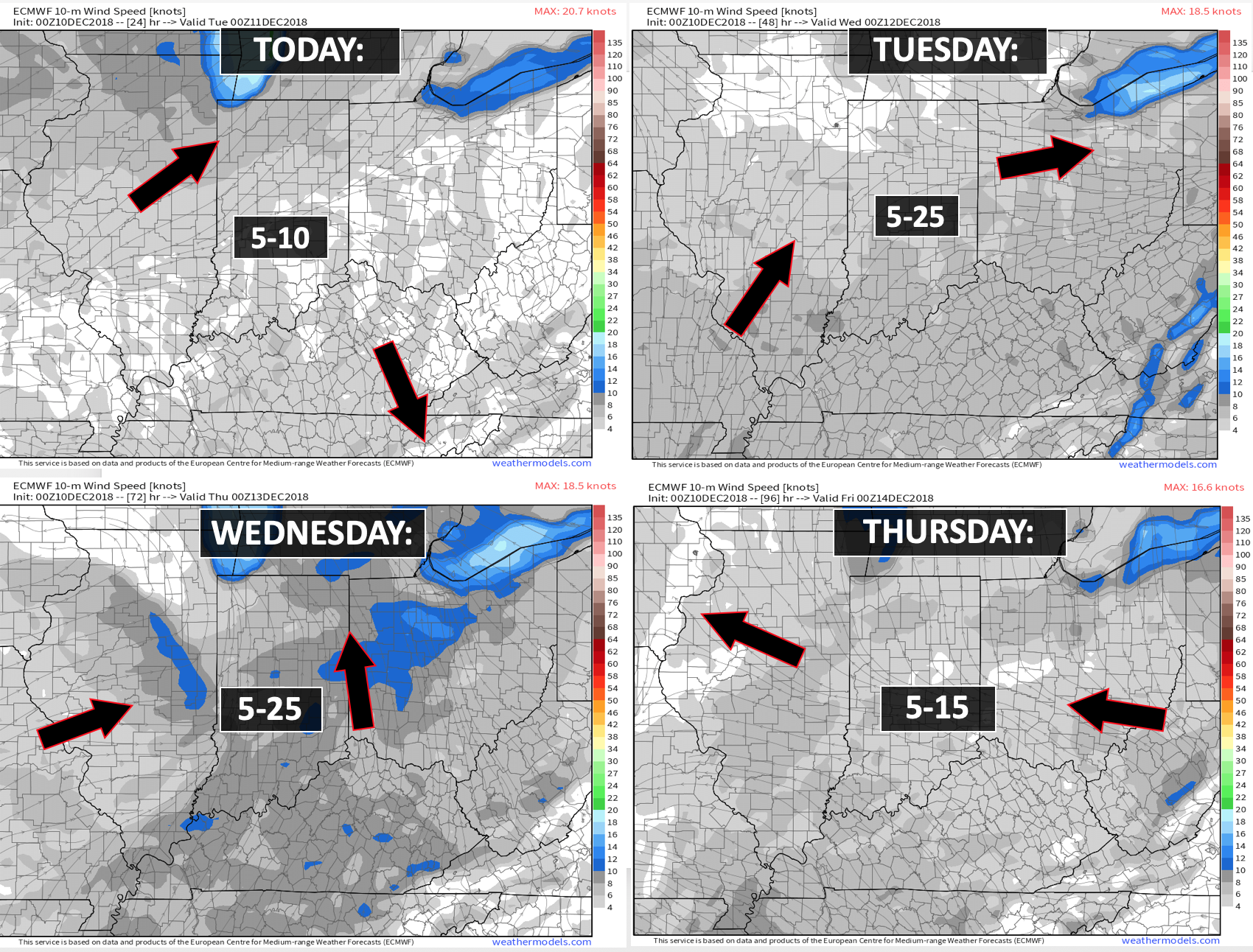

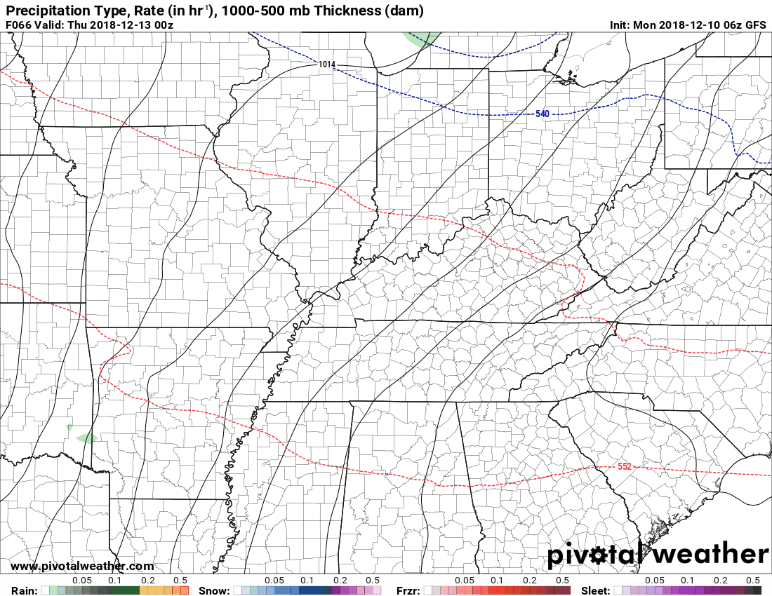
Today through Friday afternoon: A rain and rain/snow mix will be possible today. Temperatures will fall to or below freezing during the evening hours. If moisture remains on roadways then some icy spots are possible.
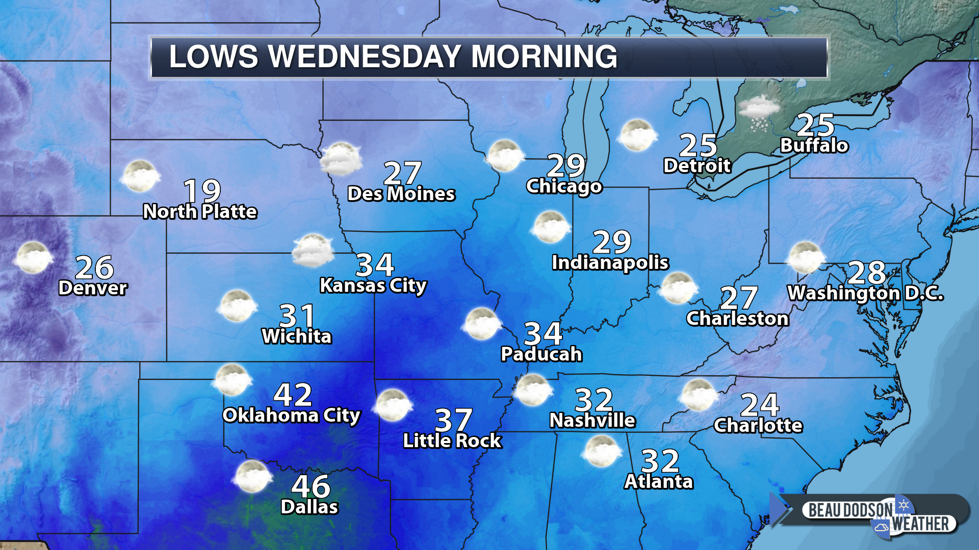
Temperatures will fall into the upper teens to middle 20’s across much of the region Thursday night.
The region should remain precipitation-free late Thursday night into Friday afternoon.
I will be monitoring the winter storm as it approaches from the southwest Friday afternoon and night. At this time, it appears most of Friday may remain dry. Then, precipitation chances may increase Friday night.
See below.
Friday night into Monday: This appears to be a Saturday PM into Sunday event. The system has slowed.
A winter storm is likely to impact portions of the central and southern United States. Significant accumulations of freezing rain, sleet, and snow are possible along the track of the winter storm. The question will be the track.
It does appear some winter weather will impact portions of our region. The southern half of the region has a better chance than northern areas. Northern areas would mean Farmington, Missouri east and northeast towards Carmi, Illinois.
If the system does phase and track further north then all of our region would experience rain and a wintry mix. Needless to say, details are going to be sketchy this far out. I will continue to fine-tune the forecast over the next few days.
If you have travel plans this weekend then you will want to monitor updated forecasts.

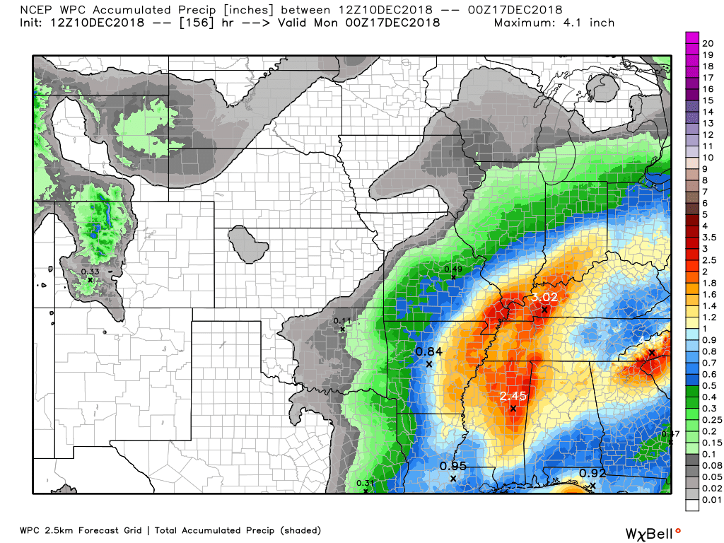
Here is the WPC/NOAA rainfall outlook
Click to enlarge.
Most of this will fall Thursday and Friday. There is some debate about the higher end totals. Certainly, an inch of rain will be likely. Pockets of one to two inches. Storm track will be a key factor in final totals. It appears most of this should be rain.
Did you know that you can find me on Twitter?

Subscribers, do you need a forecast for an outdoor event?


We offer interactive local city live radars and regional radars.
If a radar does not update then try another one. If a radar does not appear to be refreshing then hit Ctrl F5 on your keyboard.
You may also try restarting your browser. The local city view radars also have clickable warnings.
During the winter months, you can track snow and ice by clicking the winterize button on the local city view interactive radars.

Questions? Broken links? Other questions?
You may email me at beaudodson@usawx.com

The National Weather Service defines a severe thunderstorm as one that produces quarter size hail or larger, 58 mph winds or greater, and/or a tornado.
Today through Wednesday: No severe weather.
Thursday through Saturday: Monitor updates. Some thunderstorms would be possible if an area of low pressure moves to our west and north. Low confidence.
Interactive live weather radar page. Choose the city nearest your location. If one of the cities does not work then try a nearby one. Click here.
National map of weather watches and warnings. Click here.
Storm Prediction Center. Click here.
Weather Prediction Center. Click here.

Live lightning data: Click here.

Interactive GOES R satellite. Track clouds. Click here.

Here are the latest local river stage forecast numbers Click Here.
Here are the latest lake stage forecast numbers for Kentucky Lake and Lake Barkley Click Here.

- Cold to cool week ahead.
- An odd storm system to monitor midweek into the end of the week
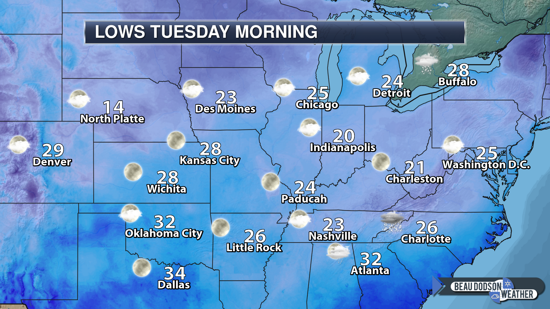
A chilly start to the week. Many areas dipped into the teens and lower twenties. A bit warmer towards the KY/TN border and parts of southeast Missouri.
8 AM temperatures
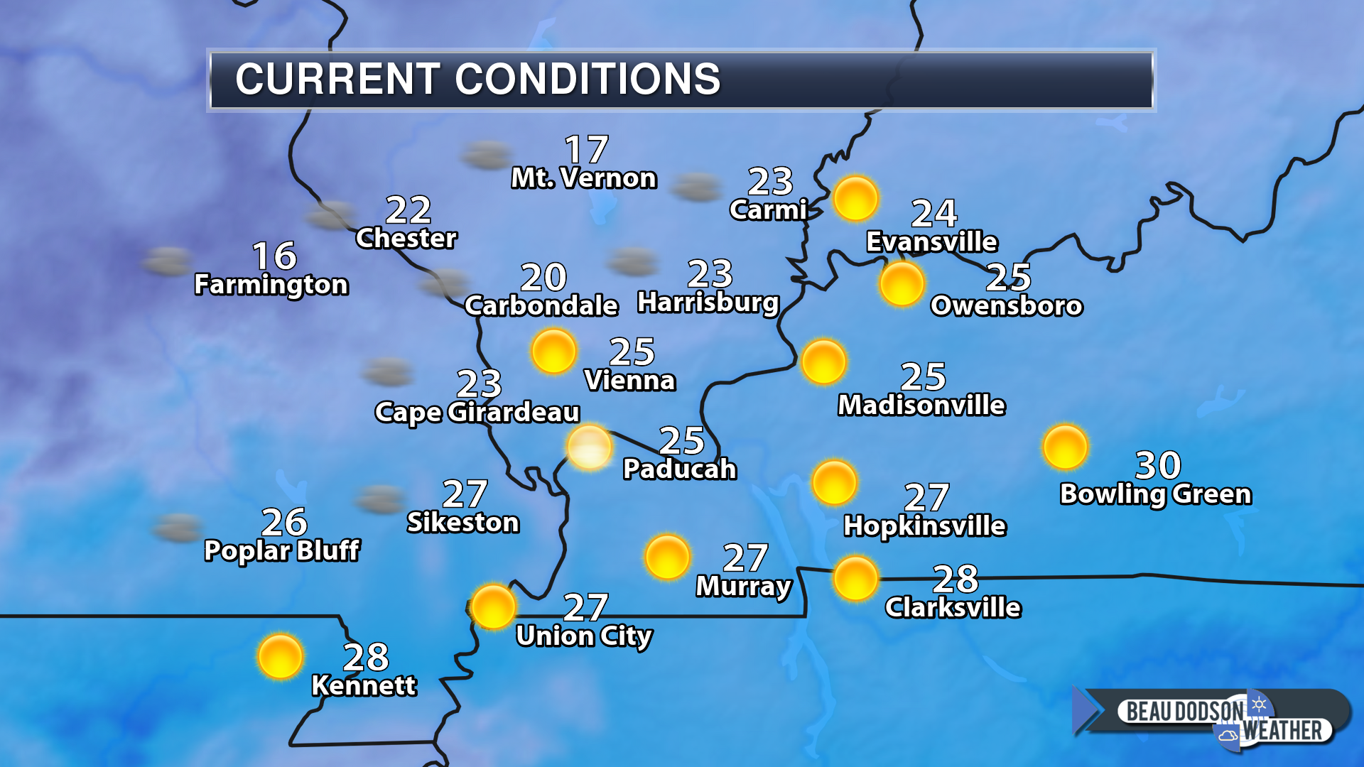
Some cool days ahead. A moderating trend is showing up Wednesday into Friday. Those milder temperatures will arrive with some rain.
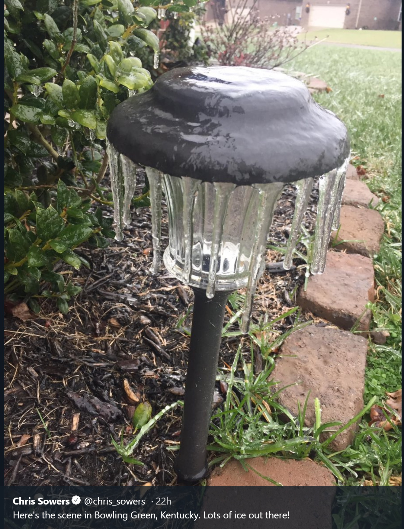
Our second winter storm of the season pushed through the MO/AR and KY/TN border area. Widespread freezing rain, sleet, and snow were reported. Freezing rain caused problems on decks, porches, stairs, and untreated roadways. Numerous accidents were reported.
Bowling Green, Kentucky ice (SUN).
That system is long gone.
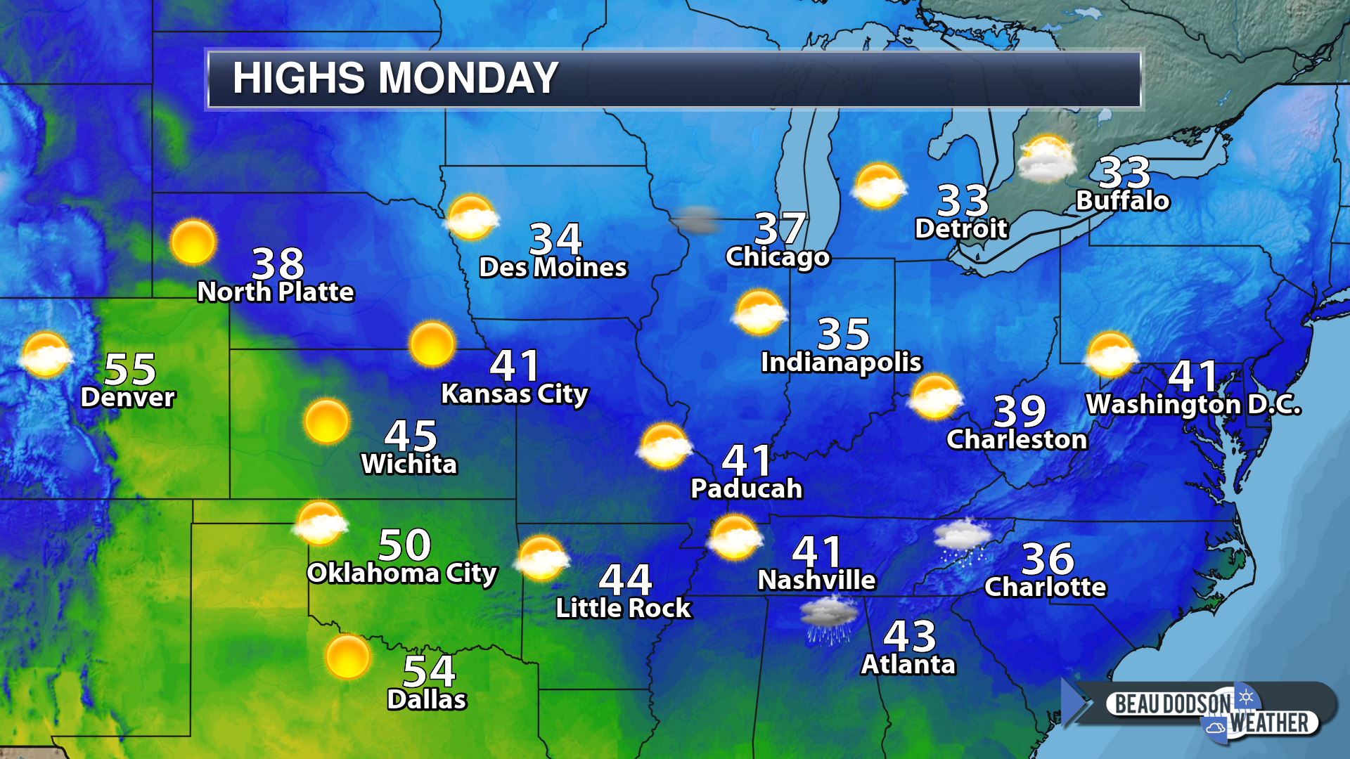
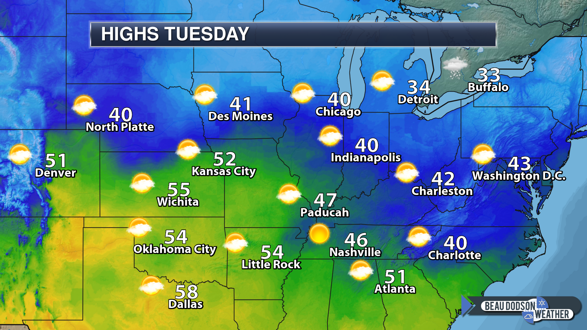
We are left with decent weather today with some sunshine. Cool temperatures. Below normal temperatures. Highs today will be in the upper 30’s to lower 40’s. Lows tonight will be in the 20’s.
Quiet weather Tuesday and Tuesday night. We will be a tad warmer on Tuesday with highs mostly in the 40’s.
Our next system winds up in the middle of the United States by Wednesday and Thursday.
A weak system passes through the area on Wednesday. This system could produce some light showers and even a snow/rain mix Wednesday night. No accumulation.
An area of low pressure will develop in Oklahoma and Texas. This low will push eastward with time and deepen.
The path of this system is a bit odd. The intensity in the model guidance is fairly strong, as well.
We will need to monitor the warm sector for thunderstorms. For now, it appears the warm sector will remain to our south and east. That would keep us out of the severe weather threat.
There is not a lot of cold air to tap into. There is, however, a chance that the system will be able to lower heights enough to produce it’s own cold air. That would mean snow on the backside. Gusty winds, as well.
For now, this looks like a rain event for our region. I will keep an eye on the snow potential.
Rain totals could top an inch with these next two systems. Total rainfall between Wednesday and Friday night will likely range in the one to two-inch rain. Heaviest rains in western Kentucky and western Tennessee.
Typically, during the winter months, this storm track would give us heavy snow.
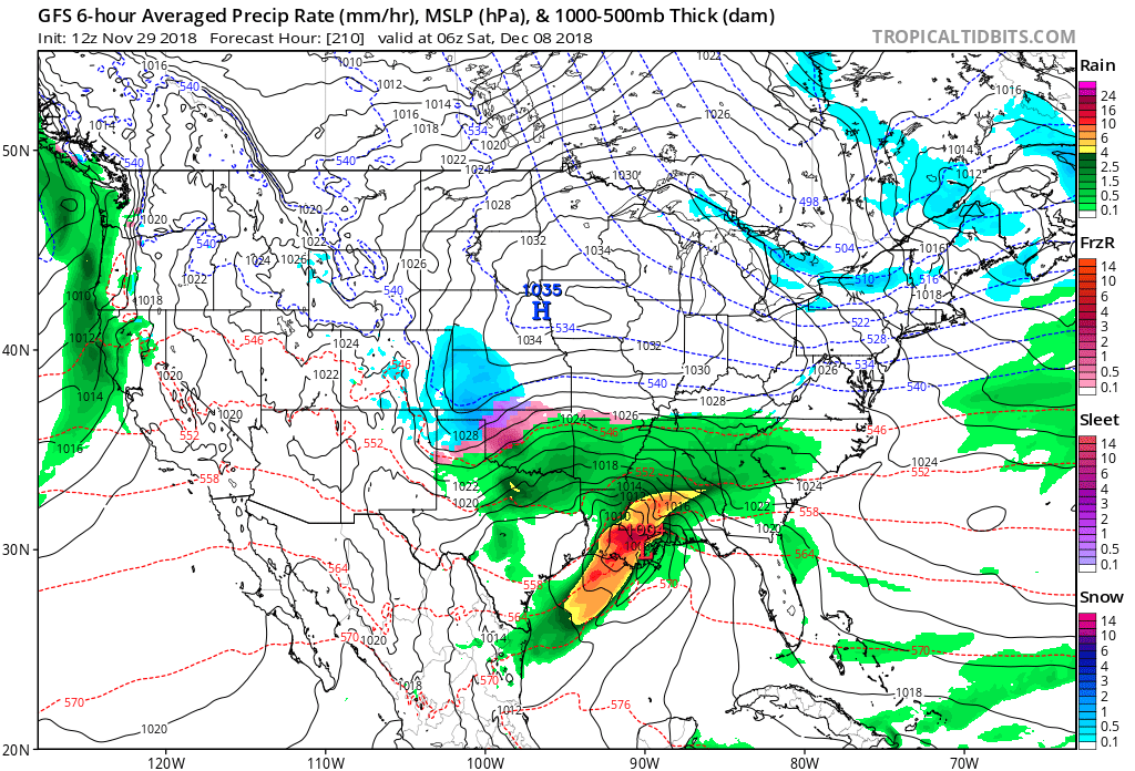
Let’s take a look at the GFS model future-cast weather radar.
Click to enlarge.
Time stamp upper-left is in Zulu time. That means 12z is 6 am, 18z is 12 pm, 0z 6 pm, 6z is 12 am.
Here are the GFS model rain totals.
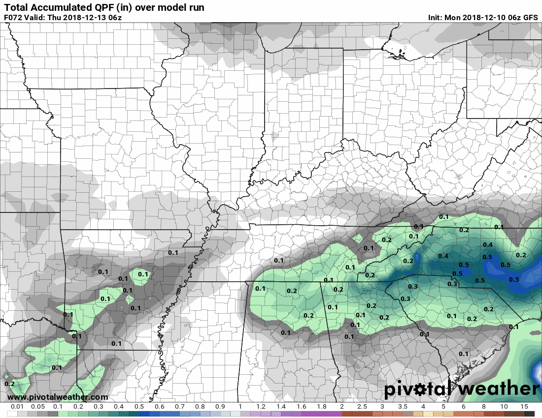
I am monitoring December 23rd through 26th for some precipitation. Way too early, of course, to know whether it would be rain or snow.
![]()

I bring these to you from the BAMwx team. They are excellent long-range forecasters.
Remember, long-range outlooks are a bit of skill, understanding weather patterns, and luck combined. It is not an exact science.

This product is for subscribers.
Subscribe at www.weathertalk.com
Subscriber graphics can be viewed on this page CLICK HERE

This product is for subscribers.

This product is for subscribers.
Subscribe at www.weathertalk.com
Subscriber graphics can be viewed on this page CLICK HERE
![]()
.
Fall Outlook!
These products are for subscribers.
November temperature and precipitation outlook
November temperature outlook
November precipitation outlook
.These products are for subscribers.
![]()

A new weather podcast is now available! Weather Geeks (which you might remember is on The Weather Channel each Sunday)
To learn more visit their website. Click here.
![]()

WeatherBrains Episode 670
Tonight’s Guest WeatherBrain is the former Meteorologist-in-charge of the National Weather Service in Mount Holly, New Jersey. Gary Szatkowski, welcome to WeatherBrains!
Other discussions in this weekly podcast include topics like:
- The difficulty of precipitation-type winter forecasting
- Snowmageddon-type event in New York similar to Atlanta/Birmingham event of 2014
- Figuring out social media as a meteorologist
- Astronomy Outlook with Tony Rice
- and more!
Link to their website https://weatherbrains.com/
Previous episodes can be viewed by clicking here.

We offer interactive local city live radars and regional radars. If a radar does not update then try another one. If a radar does not appear to be refreshing then hit Ctrl F5. You may also try restarting your browser.
The local city view radars also have clickable warnings.
During the winter months, you can track snow and ice by clicking the winterize button on the local city view interactive radars.
You may email me at beaudodson@usawx.com
Find me on Facebook!

Find me on Twitter!

Did you know that a portion of your monthly subscription helps support local charity projects?
You can learn more about those projects by visiting the Shadow Angel Foundation website and the Beau Dodson News website.

I encourage subscribers to use the app vs regular text messaging. We have found text messaging to be delayed during severe weather. The app typically will receive the messages instantly. I recommend people have three to four methods of receiving their severe weather information.
Remember, my app and text alerts are hand typed and not computer generated. You are being given personal attention during significant weather events.
