


Videos can be viewed at this link. Long Range Video Update
If you believe you missed a video then you can also click the LIVE FEED link on the Weather Talk website. That page holds links for several days.
I can text you the videos, as well. Make sure you have text option FOUR turned on. That would be the Weather Extra text option. Sign up for the text messages at www.beaudodsonweather.com
.

.
This forecast update covers southern Illinois, southeast Missouri, western Kentucky. and northwest Tennessee.
.
The following link is for Weather Text subscribers. This is the page where short and long range video outlooks have been posted. The videos are being produced by a team of meteorologists. Some of the best in the region.
https://weathertalk.com/app/beaucast
Thursday Forecast Details
Forecast: Warm and more humid. Quite a bit of sun with some scattered clouds. Isolated thunderstorms over western Tennessee and areas near the Kentucky/Tennessee State line.
Temperatures: MO ~ 82 to 86 IL ~ 82 to 86 KY ~ 82 to 86 TN ~ 82 to 86
Winds: East and northeast winds at 5 to 10 mph.
What impacts are anticipated from the weather? Isolated wet roadways and lightning.
My confidence in the forecast verifying: Medium. Some adjustments are possible
Is severe weather expected? No
The NWS defines severe weather as 58 mph winds or great, 1″ hail or larger, and/or tornadoes
What is the chance of precipitation? MO ~ 10% IL ~ 10% KY ~ 20% TN ~ 30%
Coverage of precipitation: Isolated.
Should I cancel my outdoor plans? Check radars and the latest forecast.
Thursday Night Forecast Details:
Forecast: Partly to mostly cloudy. Better chances of clouds over far southeast Missouri, Kentucky, and Tennessee. A few showers and thunderstorms possible, especially over our southern counties near the MO/AR and KY/TN border.
Temperatures: MO ~ 65 to 70 IL ~ 65 to 70 KY ~ 65 to 70 TN ~ 65 to 70
Winds: South and southwest winds at 5 to 10 mph. Winds variable at times.
What impacts are anticipated from the weather? Isolated wet roadways and lightning.
My confidence in the forecast verifying: Medium. Some adjustments are possible.
Is severe weather expected? No
The NWS defines severe weather as 58 mph winds or great, 1″ hail or larger, and/or tornadoes
What is the chance of precipitation? MO ~ 20% IL ~ 20% KY ~ 30% TN ~ 30%
Coverage of precipitation: Isolated to scattered.
Should I cancel my outdoor plans? No, but check radars.
.
August 11, 2017
Friday Forecast Details
Forecast: Partly sunny. Warm. Humid. Scattered showers and thunderstorms.
Temperatures: MO ~ 82 to 86 IL ~ 82 to 86 KY ~ 82 to 86 TN ~ 82 to 86
Winds: South and southwest winds at 5 to 10 mph with gusts to 12 mph.
What impacts are anticipated from the weather? Wet roadways and lightning.
My confidence in the forecast verifying: Medium. Some adjustments are possible.
Is severe weather expected? Small risk for damaging winds.
The NWS defines severe weather as 58 mph winds or great, 1″ hail or larger, and/or tornadoes
What is the chance of precipitation? MO ~ 40% IL ~ 40% KY ~ 40% TN ~ 50%
Coverage of precipitation: Scattered.
Should I cancel my outdoor plans? No, but check updates.
.
Friday Night Forecast Details:
Forecast: Quite a few clouds. Any remaining showers and thunderstorms will come to an end. Cooler north vs south. A boundary will divide the area.
Temperatures: MO ~ 62 to 68 (cooler northern counties vs south) IL ~ 60 to 70 (cooler northern counties vs southern) KY ~ 65 to 70 TN ~ 65 to 70
Winds: Variable winds at 5 to 10 mph. winds becoming west/southwest.
What impacts are anticipated from the weather? Scattered wet roadways and lightning.
My confidence in the forecast verifying: Medium. Some adjustments are possible.
Is severe weather expected? A few storms could produce strong winds. Low severe weather risk.
The NWS defines severe weather as 58 mph winds or great, 1″ hail or larger, and/or tornadoes
What is the chance of precipitation? MO ~ 30% IL ~ 30% KY ~ 30% TN ~ 40%
Coverage of precipitation: Scattered.
Should I cancel my outdoor plans? No, but I would check radars and updated numbers.
.
August 12, 2017
Saturday Forecast Details
Forecast: Partly to mostly sunny. A small chance for a thunderstorm. Most of the region should be dry.
Temperatures: MO ~ 82 to 86 IL ~ 82 to 86 KY ~ 82 to 86 TN ~ 82 to 86
Winds: Northerly winds at 5 to 10 mph with gusts to 14 mph.
What impacts are anticipated from the weather? Most likely none. Small chance for wet roadways and lightning along the KY/TN border southward.
My confidence in the forecast verifying: Medium. Some adjustments possible.
Is severe weather expected? No
The NWS defines severe weather as 58 mph winds or great, 1″ hail or larger, and/or tornadoes
What is the chance of precipitation? MO ~ 20% IL ~ 10% KY ~ 20% TN ~ 30%
Coverage of precipitation: Isolated to none.
Should I cancel my outdoor plans? No, but check updates.
.
Saturday Night Forecast Details:
Forecast: Partly to mostly cloudy. Isolated shows and thunderstorms possible.
Temperatures: MO ~ 65 to 70 IL ~ 65 to 70 KY ~ 65 to 70 TN ~ 65 to 70
Winds: Variable winds at 5 to 10 mph. Winds mostly northerly.
What impacts are anticipated from the weather? Most likely none. Isolated wet roadways and lightning.
My confidence in the forecast verifying: Low. Significant adjustments possible
Is severe weather expected? No
The NWS defines severe weather as 58 mph winds or great, 1″ hail or larger, and/or tornadoes
What is the chance of precipitation? MO ~ 20% IL ~ 20% KY ~ 30% TN ~ 30%
Coverage of precipitation: Isolated
Should I cancel my outdoor plans? No, but check updates.
.
August 13, 2017
Sunday Forecast Details
Forecast: Quite a few clouds with a chance for showers and thunderstorms.
Temperatures: MO ~ 80 to 85 IL ~ 80 to 85 KY ~ 80 to 85 TN ~ 80 to 85
Winds: Variable winds at 5 to 10 mph with gusts to 14 mph.
What impacts are anticipated from the weather? Wet roadways. Lightning.
My confidence in the forecast verifying: Medium. Some adjustments possible.
Is severe weather expected? Monitor updates.
The NWS defines severe weather as 58 mph winds or great, 1″ hail or larger, and/or tornadoes
What is the chance of precipitation? MO ~ 50% IL ~ 50% KY ~ 50% TN ~ 50%
Coverage of precipitation: Scattered.
Should I cancel my outdoor plans? No, but check updates. There will be a cold front near our region. Rain is possible.
.
Sunday Night Forecast Details:
Forecast: Partly cloudy. Scattered showers and thunderstorms possible.
Temperatures: MO ~ 64 to 68 IL ~ 64 to 68 KY ~ 64 to 68 TN ~ 64 to 68
Winds: North and northeast winds at 4 to 8 mph
What impacts are anticipated from the weather? Scattered wet roadways and lightning.
My confidence in the forecast verifying: Low. Significant adjustments possible.
Is severe weather expected? Unlikely, but monitor updates
The NWS defines severe weather as 58 mph winds or great, 1″ hail or larger, and/or tornadoes
What is the chance of precipitation? MO ~ 40% IL ~ 40% KY ~ 40% TN ~ 40%
Coverage of precipitation: Isolated to scattered.
Should I cancel my outdoor plans? No, but check updates
.
August 14, 2017
Monday Forecast Details
Forecast: Partly sunny. A chance for scattered thunderstorms.
Temperatures: MO ~ 76 to 84 IL ~ 76 to 84 KY ~ 76 to 84 TN ~ 76 to 84
Winds: East winds at 5 to 10 mph with gusts to 15 mph.
What impacts are anticipated from the weather? Wet roadways. Lightning.
My confidence in the forecast verifying: Low. Significant adjustments possible.
Is severe weather expected? Unlikely.
The NWS defines severe weather as 58 mph winds or great, 1″ hail or larger, and/or tornadoes
What is the chance of precipitation? MO ~ 40% IL ~ 40% KY ~ 40% TN ~ 40%
Coverage of precipitation: Scattered.
Should I cancel my outdoor plans? No, but check updates. There will be a cold front near our region. Rain is possible.
.
Monday Night Forecast Details:
Forecast: Partly cloudy. Isolated showers and thunderstorms possible.
Temperatures: MO ~ 65 to 70 IL ~ 65 to 70 KY ~ 65 to 70 TN ~ 65 to 70
Winds: Variable winds at 5 to 10 mph
What impacts are anticipated from the weather? Scattered wet roadways and lightning.
My confidence in the forecast verifying: Low. Significant adjustments possible
Is severe weather expected? No
The NWS defines severe weather as 58 mph winds or great, 1″ hail or larger, and/or tornadoes
What is the chance of precipitation? MO ~ 30% IL ~ 30% KY ~ 30% TN ~ 30%
Coverage of precipitation: Isolated
Should I cancel my outdoor plans? No
.
August 15, 2017
Tuesday Forecast Details
Forecast: Partly to mostly sunny.
Temperatures: MO ~ 75 to 80 IL ~ 75 to 80 KY ~ 75 to 80 TN ~ 75 to 80
Winds: North and northeast winds at 5 to 10 mph.
What impacts are anticipated from the weather? Most likely none.
My confidence in the forecast verifying: Low. Significant adjustments possible.
Is severe weather expected? No
The NWS defines severe weather as 58 mph winds or great, 1″ hail or larger, and/or tornadoes
What is the chance of precipitation? MO ~ 10% IL ~ 10% KY ~ 10% TN ~ 10%
Coverage of precipitation: Most likely none
Should I cancel my outdoor plans? No
.
Tuesday Night Forecast Details:
Forecast: Partly cloudy.
Temperatures: MO ~ 65 to 70 IL ~ 65 to 70 KY ~ 65 to 70 TN ~ 65 to 70
Winds: North and northeast winds at 5 to 10 mph
What impacts are anticipated from the weather?
My confidence in the forecast verifying: Medium. Some adjustments possible.
Is severe weather expected?
The NWS defines severe weather as 58 mph winds or great, 1″ hail or larger, and/or tornadoes
What is the chance of precipitation? MO ~ 20% IL ~ 20% KY ~ 20% TN ~ 20%
Coverage of precipitation:
Should I cancel my outdoor plans.
.
August 15, 2017
Wednesday Forecast Details
Forecast: Mostly sunny. Mild.
Temperatures: MO ~ 80 to 85 IL ~ 80 to 85 KY ~ 80 to 85 TN ~ 80 to 85
Winds: Light and variable
What impacts are anticipated from the weather? None
My confidence in the forecast verifying: Low. Significant adjustments possible.
Is severe weather expected? No
The NWS defines severe weather as 58 mph winds or great, 1″ hail or larger, and/or tornadoes
What is the chance of precipitation? MO ~ 0% IL ~ 0% KY ~ 0% TN ~ 0%
Coverage of precipitation: None
Should I cancel my outdoor plans? No
.
Wednesday Night Forecast Details:
Forecast: Partly cloudy.
Temperatures: MO ~ 65 to 70 IL ~ 65 to 70 KY ~ 65 to 70 TN ~ 65 to 70
Winds: Variable less than 10 mph
What impacts are anticipated from the weather? None
My confidence in the forecast verifying: Low. Significant adjustments are possible.
Is severe weather expected? No
The NWS defines severe weather as 58 mph winds or great, 1″ hail or larger, and/or tornadoes
What is the chance of precipitation? MO ~ 0% IL ~ 0% KY ~ 0% TN ~ 0%
Coverage of precipitation: None
Should I cancel my outdoor plans? No
.

Don’t forget to check out the Southern Illinois Weather Observatory web-site for weather maps, tower cams, scanner feeds, radars, and much more! Click here

A severe thunderstorm is defined as a storm that produces quarter size hail or larger, 58 mph winds or greater, and/or a tornado. That is the official National Weather Service definition of a severe thunderstorm.
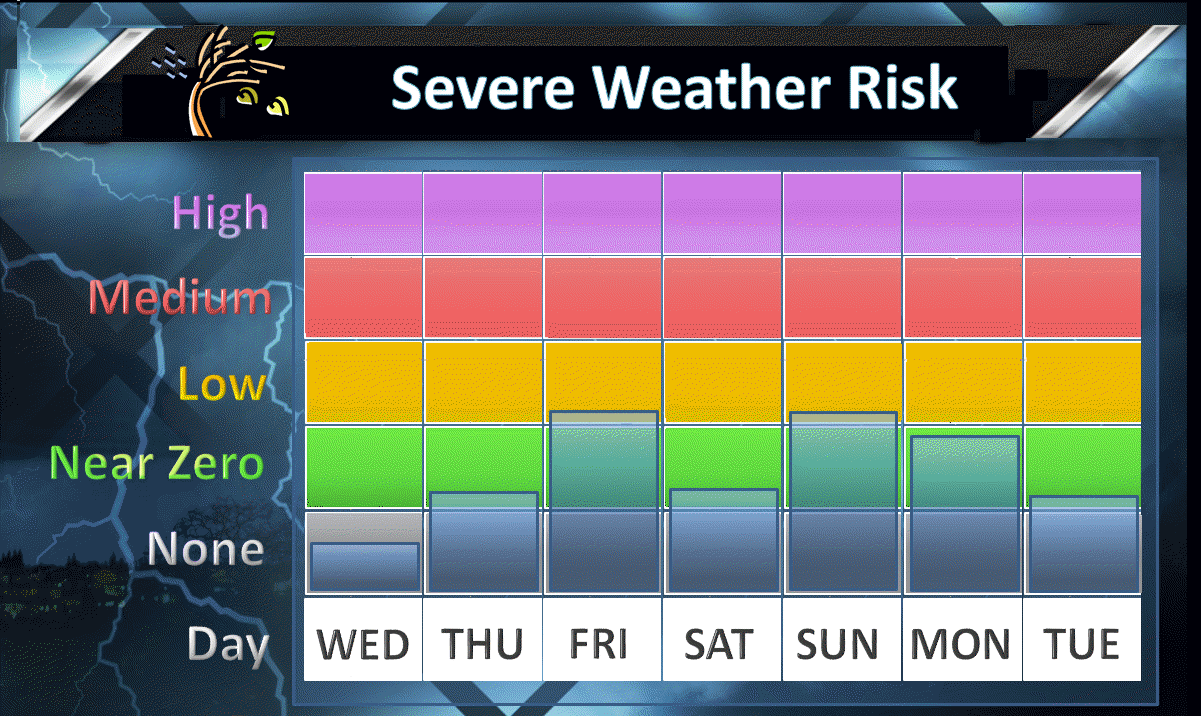
Wednesday night through Monday: Severe weather is not anticipated.
We will have thunderstorms in the forecast, but the severe weather risk is low. Lightning will be the main concern. A couple of storms could produce high winds, but the overall risk is low.

A semi-unsettled pattern over the coming days. Confidence in the details is rather low. I would recommend checking back for updates.
Wednesday night’s weather will be controlled by an area of high pressure to our north. This high will slowly edge eastward over the coming 48 hours. This will mean a return to easterly/southerly winds. Southerly winds will mean an increase in moisture. Dew points will be on the rise as we move further into the week and weekend.
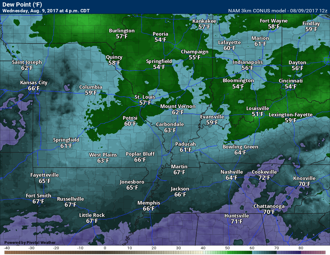
Wednesday dew points were mostly in the 60’s. There were some 50’s over our northeast counties. Dew points in the 50’s feel great.
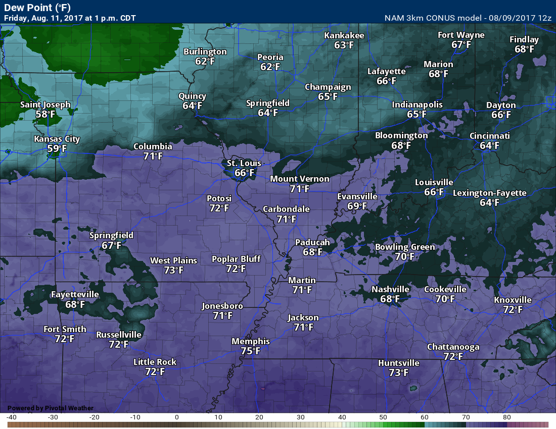
Friday dew points. Considerably higher. Uncomfortable levels. Thankfully, temperatures won’t be all that hot.
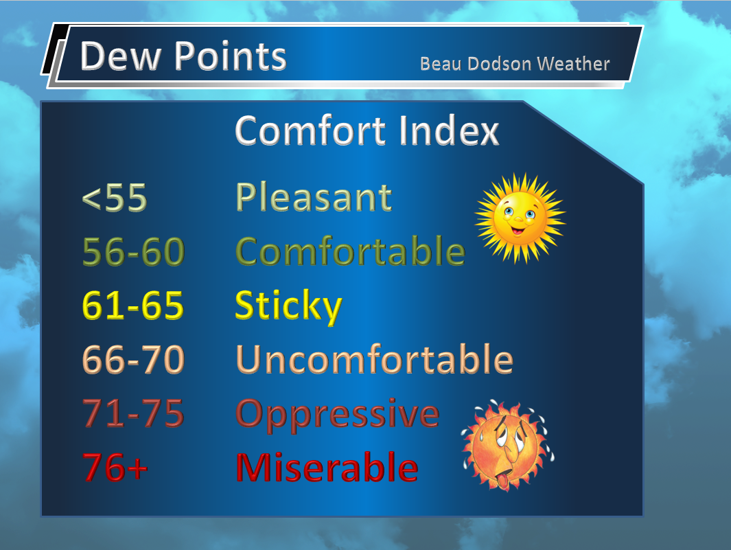
Your dew point scale
Keep in mind, dew points in the 70’s are uncomfortable, but without temperatures in the 90’s they are not nearly as bad. July had temperatures in the 90’s with dew points in the 70’s. Tropical.
A series of weak disturbances will push through the region between now and next Tuesday. Each disturbance could trigger a few showers and thunderstorms.
The real question is coverage.
A warm front is located to our south, here on Wednesday evening, and it is slowly inching northward.
You can see the front on the Thursday morning weather map. Perhaps a few showers will approach northeast Arkansas, the Bootheel of Missouri, and northwest Tennessee on Thursday.
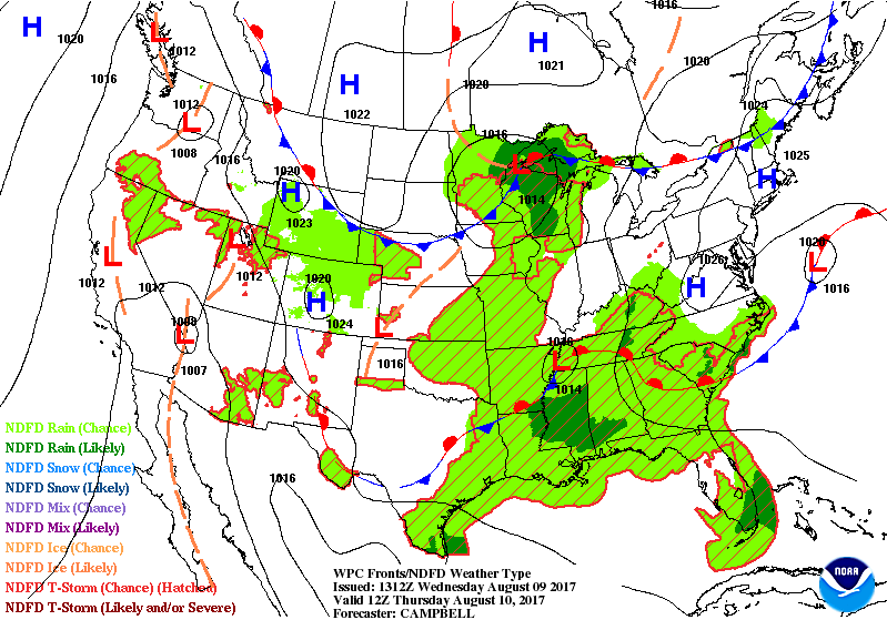
Meanwhile, a cold front will advance into the region from the north on Friday. This front will eventually stall over our region.
You can see the front here on the Friday weather map
The widespread green represents rain, but don’t get overly excited just yet. That color code means scattered precipitation.
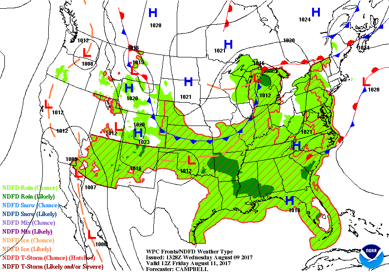
Where the front stalls will be key to our weather forecast. If the front sinks far enough south then we will shut down rain chances. If the front stalls over our region then we will have at least 30% to 40% rain chances on Friday, Saturday, Sunday, and perhaps Monday. There could also be time periods with high probabilities. We won’t know this until closer to the time period in question.
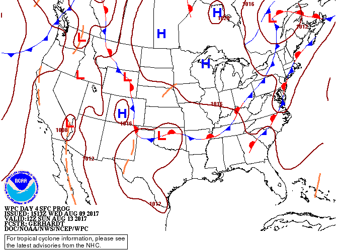
Here is the forecast map for Sunday and Monday
7 AM Sunday map. The front stalls near our region (southern half).
Monday map. The WPC has the front draped over our region.
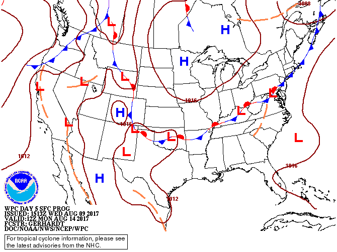
Confidence in the details is low. I do not have a good handle on where the front will stall.
What happens is disturbances move along the stationary front. Each disturbance can produce lift. Lift would mean scattered showers and thunderstorms.
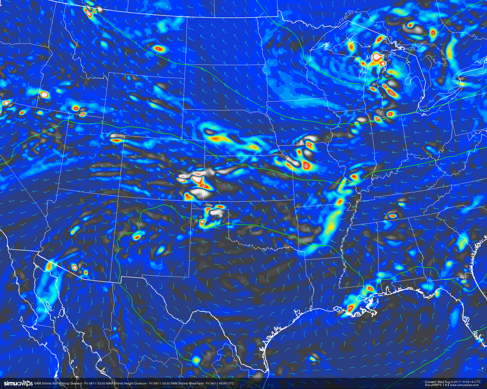
A little bit of meteorology for you. This is the 500 mb vorticity map. Those little pockets of bright colors are shortwaves or disturbances. Each one produces lift.
This first map is Thursday night. You can see a weak disturbance moving through our local area.
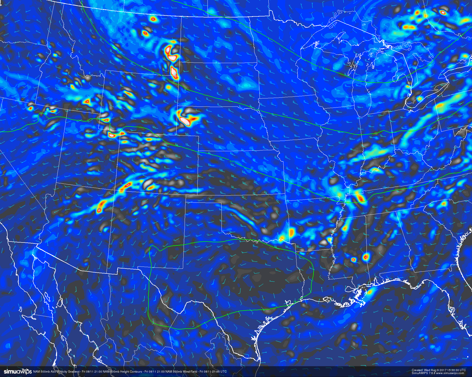
This next map is for Friday afternoon
This next map is for Saturday afternoon
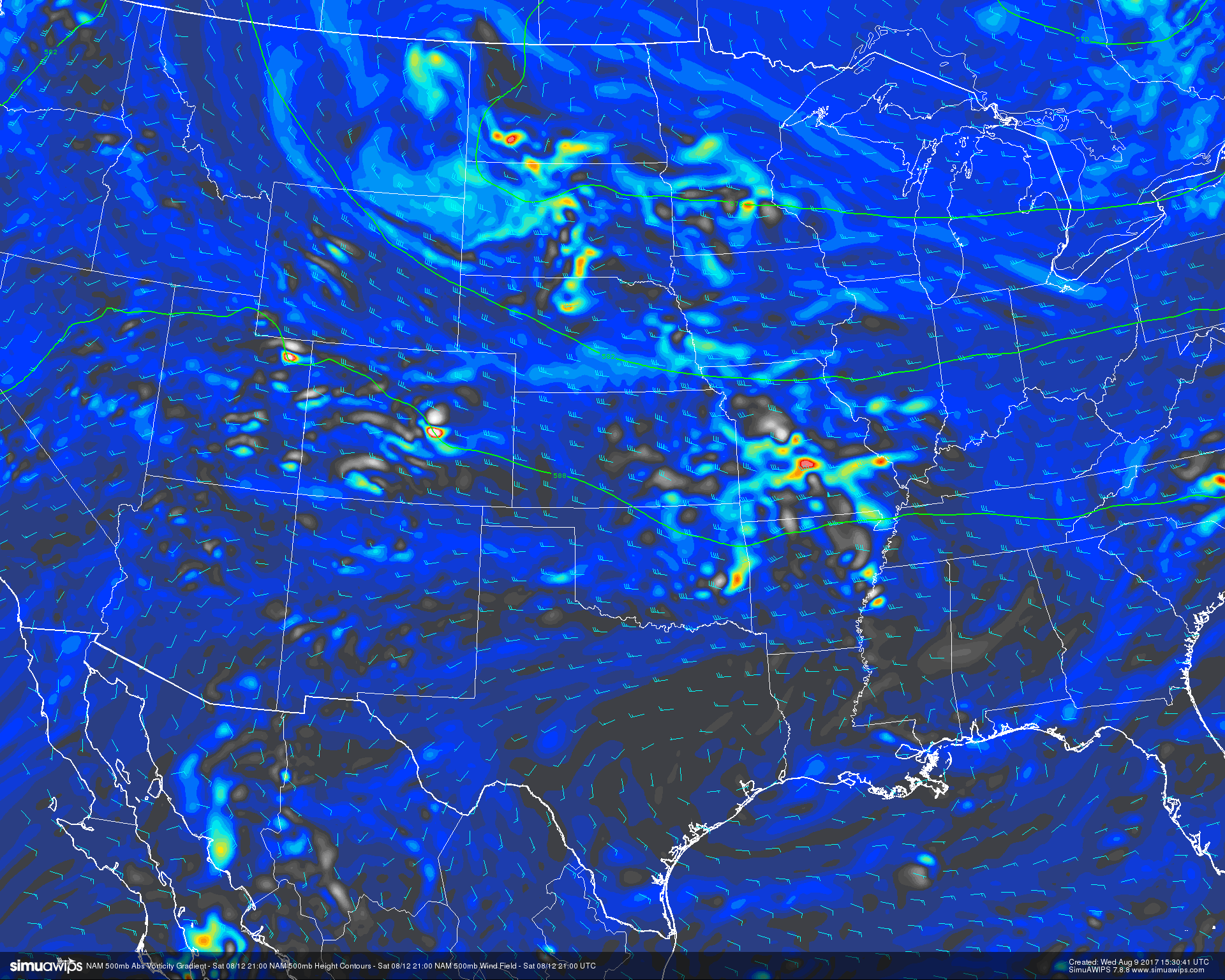
These type of disturbances are difficult to forecast.
I am not going to post future-cast radar maps. They are worthless. Each model is different. Models show anywhere from no rain at all over the coming days to several inches.
One thing seems likely, the best chance for rain should be over the southern half of the region. Draw a line from Poplar Bluff, Missouri, towards Vienna, Illinois, and then into western Kentucky. From there southward.
That does not mean it won’t rain north of that line. It just means the percentage odds are greater along and south of the line.
I have shower and thunderstorms in the forecast for Thursday, Friday, Saturday, Sunday, and Monday. Coverage is questionable. Probabilities are questionable. Sorry, that is the best I can do, for now. Keep checking back.
If you have weekend plans, then monitor updated forecast numbers. Check radars. I would not cancel any activities, yet. I would have a back up plan in mind. Better safe than sorry.
Eclipse Weather
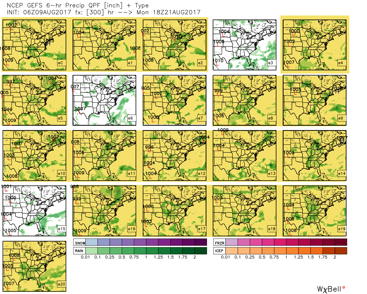
Ensembles are showing rain and clouds for the eclipse. It is still way too early for a real forecast, but I don’t like the ensembles. They would indicate poor viewing conditions. Let’s hope they are wrong.
This is the same model, but run with slightly different beginning parameters. The goal is to see how many of the panels agree. Large agreement raises confidence in the forecast. We are pushing the envelop for extended range. PLENTY of days to monitor. Plenty of days for adjustments. Confidence in the forecast probably won’t rise until next Thursday.
Right now, the yellow boxes indicate a run that shows clouds and rain. Obviously, this is not great news. The good news, however, is that we still have many days left for adjustments and changes.
Fingers crossed.
Are you subscribing to the Weather Talk texts and videos?
We now have premiere videos for the short and long range forecasts! Make sure you have text option four turned on (green).
Sign up at www.beaudodsonweather.com
We also have an Apple and Android app (scroll down to bottom of the page for more information)

Were you aware that I have hired some help for long range videos? Short range videos, as well. An amazing team of meteorologists.
Click the link below to read more
http://cms.weathertalk.com/meet-the-team/
Weather Talk subscribers now have some of the best short and long range weather videos produced across the eastern United States.
.

Find me on Twitter
.

We have regional radars and local city radars – if a radar does not update then try another one. Occasional browsers need their cache cleared. You may also try restarting your browser. That usually fixes the problem. Occasionally we do have a radar go down. That is why I have duplicates. Thus, if one fails then try another one.
During the winter you can track snow and ice by clicking the winterize button on the local city view interactive radars.
If you have any problems then please send me an email beaudodson@usawx.com
Interactive Weather Radar Page. Choose the city nearest your location: Click this link—
National interactive radar: Click this link.
Local interactive city radars include St Louis, Mt Vernon, Evansville, Poplar Bluff, Cape Girardeau, Marion, Paducah, Hopkinsville, Memphis, Nashville, Dyersburg, and all of eastern Kentucky. These are interactive radars. Local city radars – click here
The Beau Dodson Weather APP is ready for Apple and Android users. The purpose of this app is for me to deliver your text messages instantly. ATT and Verizon have not always been reliable when it comes to speed. The app allows instant delivery.
Some of you have asked if you can keep receiving the texts on your phone and the app. The answer to that is, yes. The Android app will automatically allow that to happen. On the Apple app, however, you will need to go into your app and click settings. Make sure the green tab is OFF. Off means you will still receive the texts to your phone and the app. If you have any questions, then email me at beaudodson@usawx.com
The app is for text subscribers.
The direct download, for the Apple app, can be viewed here
https://itunes.apple.com/us/app/id1190136514
If you have not signed up for the texting service then you may do so at www.beaudodsonweather.com

The Android app is also ready.
Remember, the app’s are for www.weathertalk.com subscribers. The app allows your to receive the text messages faster than ATT and Verizon.
Here is the download link for the Android version Click Here

——————————————————–
If you have not signed up for the texts messages, then please do. Link www.beaudodsonweather.com
Your support helps with the following:

and


Who do you trust for your weather information and who holds them accountable?
I have studied weather in our region since the late 1970’s. I have 39 years of experience in observing our regions weather patterns. My degree is in Broadcast Meteorology and a Bachelor’s of Science.
My resume includes:
Member of the American Meteorological Society.
NOAA Weather-Ready Nation Ambassador.
Meteorologist for McCracken County Emergency Management. I served from 2005 through 2015.
Meteorologist for McCracken County Rescue. 2015 through current
I own and operate the Southern Illinois Weather Observatory.
I am the chief meteorologist for Weather Talk LLC. I am the owner of Weather Talk LLC.
I am also a business owner in western Kentucky.
Recipient of the Mark Trail Award, WPSD Six Who Make A Difference Award, Kentucky Colonel, and the Caesar J. Fiamma” Award from the American Red Cross.
In 2005 I helped open the largest American Cross shelter in U.S. history in Houston, Texas. I was deployed to help after Hurricane Katrina and Hurricane Rita. I was a shelter manager of one of the Houston, Texas shelter divisions.
In 2009 I was presented with the Kentucky Office of Highway Safety Award.
Recognized by the Kentucky House of Representatives for my service to the State of Kentucky leading up to several winter storms and severe weather outbreaks.
If you click on the image below you can read the Kentucky House of Representatives Resolution.

I am also President of the Shadow Angel Foundation which serves portions of western Kentucky and southern Illinois.
There is a lot of noise on the internet. A lot of weather maps are posted without explanation. Over time you should learn who to trust for your weather information.
My forecast philosophy is simple and straight forward.
- Communicate in simple terms
- To be as accurate as possible within a reasonable time frame before an event
- Interact with you on Twitter, Facebook, email, texts, and this blog
- Minimize the “hype” that you might see on some television stations or through other weather sources
- Push you towards utilizing wall-to-wall LOCAL TV coverage during severe weather events
Many of the graphics on this page are from www.weatherbell.com
WeatherBell is a great resource for weather model guidance.


You can sign up for my AWARE email by clicking here I typically send out AWARE emails before severe weather, winter storms, or other active weather situations. I do not email watches or warnings. The emails are a basic “heads up” concerning incoming weather conditions