


Videos can be viewed at this link. Long Range Video Update
If you believe you missed a video then you can also click the LIVE FEED link on the Weather Talk website. That page holds links for several days.
I can text you the videos, as well. Make sure you have text option FOUR turned on. That would be the Weather Extra text option. Sign up for the text messages at www.beaudodsonweather.com
.
 .
..
This forecast update covers southern Illinois, southeast Missouri, western Kentucky. and northwest Tennessee.
.
The following link is for Weather Text subscribers. This is the page where short and long range video outlooks have been posted. The videos are being produced by a team of meteorologists. Some of the best in the region.
https://weathertalk.com/app/beaucast
.
Radars
Your local city view interactive radars
http://www.weatherobservatory.com/weather-radar.htm
.
August 3, 2017
Thursday Night Forecast Details:
Forecast: Becoming cloudy. A few evening storms possible. A band of late night showers and thunderstorms passing through the region from northwest to southeast. Some areas will likely receive no rainfall.
Temperatures: MO ~ 66 to 72 IL ~ 66 to 72 KY ~ 66 to 72 TN ~ 66 to 72
Winds: South winds at 7 to 14 mph with higher gusts likely late. Winds becoming southwest and then eventually west/northwest behind the cold front (late Thursday night).
What impacts are anticipated from the weather? Wet roadways. Lightning.
My confidence in the forecast verifying: Medium. Some adjustments are possible.
Is severe weather expected? Small risk for strong winds in thunderstorms
The NWS defines severe weather as 58 mph winds or great, 1″ hail or larger, and/or tornadoes
What is the chance of precipitation? MO ~ 50% IL ~ 50% KY ~ 50% TN ~ 50%
Coverage of precipitation: Scattered
Should I cancel my outdoor plans? Have a plan B, in case there are some rain showers/storms in the region. The greatest chance for showers and storms will arrive late Thursday night into Friday morning.
.
August 4, 2017
Friday Forecast Details
Forecast: Some morning clouds with scattered showers and thunderstorms. Low confidence on timing of frontal passage. If the front is slower, then rain chances linger until mid-morning. Becoming partly to mostly sunny as the day wears on. Dew points falling to comfortable levels as the day wears on.
Temperatures: MO ~ 76 to 82 IL ~ 76 to 82 KY ~ 76 to 82 TN ~ 76 to 82
Winds: West and northwest at 7 to 14 mph with perhaps some higher gusts.
What impacts are anticipated from the weather? Morning wet roadways and lightning (before 11 am)
My confidence in the forecast verifying: Medium. Some adjustments are possible.
Is severe weather expected? No
The NWS defines severe weather as 58 mph winds or great, 1″ hail or larger, and/or tornadoes
What is the chance of precipitation? MO ~ 30% IL ~ 30% KY ~ 40% TN ~ 40%
Coverage of precipitation: Rain will end from west to east. A band of showers and storms.
Should I cancel my outdoor plans? No, but monitor updates in case the front is slower than anticipated.
.
Friday Night Forecast Details:
Forecast: Clearing. Cooler. Less humid. Pleasant night. Great camping weather.
Temperatures: MO ~ 56 to 64 IL ~ 56 to 64 KY ~ 56 to 64 TN ~ 56 to 64
Winds: North/northwest winds at 6 to 12 mph early becoming north and northwest at 0 to 5 mph.
What impacts are anticipated from the weather? None
My confidence in the forecast verifying: High. This forecast should verify.
Is severe weather expected? No
The NWS defines severe weather as 58 mph winds or great, 1″ hail or larger, and/or tornadoes
What is the chance of precipitation? MO ~ 0% IL ~ 0% KY ~ 0% TN ~ 0%
Coverage of precipitation: None
Should I cancel my outdoor plans? No.
.
August 5, 2017
Saturday Forecast Details
Forecast: Mostly sunny before 1 pm. Increasing clouds late. A small chance for an afternoon shower over mainly southeast Missouri. Cooler. Less humid.
Temperatures: MO ~ 76 to 84 IL ~ 76 to 84 KY ~ 76 to 84 TN ~ 76 to 84
Winds: North winds at 6 to 12 mph. Winds becoming east/northeast at 5 to 10 mph.
What impacts are anticipated from the weather? Most likely none
My confidence in the forecast verifying: High. This forecast should verify.
Is severe weather expected? No
The NWS defines severe weather as 58 mph winds or great, 1″ hail or larger, and/or tornadoes
What is the chance of precipitation? MO ~ 20% IL ~ 10% KY ~ 10% TN ~ 0%
Coverage of precipitation: Mostly likely none. I will be watching rain move through Missouri Saturday afternoon. I can’t completely rule out it moving into some of my forecast counties late in the day (SE MO, mainly).
Should I cancel my outdoor plans? No
.
Saturday Night Forecast Details:
Forecast: Increasing clouds. Cool. An increasing chance for showers and thunderstorms as the night wears on.
Temperatures: MO ~ 58 to 64 IL ~ 56 to 62 KY ~ 58 to 64 TN ~ 58 to 64
Winds: North winds at 5 to 10 mph. Winds becoming east and southeast at 3 to 6 mph
What impacts are anticipated from the weather? Wet roadways and lightning.
My confidence in the forecast verifying: Medium. Some adjustments possible.
Is severe weather expected? No
The NWS defines severe weather as 58 mph winds or great, 1″ hail or larger, and/or tornadoes
What is the chance of precipitation? MO ~ 50% IL ~ 50% KY ~ 30% TN ~ 30%
Coverage of precipitation: Scattered to perhaps increasing coverage late
Should I cancel my outdoor plans? No.
.
August 6, 2017
Sunday Forecast Details
Forecast: Mostly cloudy. A bit warmer. Showers and thunderstorms likely. Locally heavy rain possible.
Temperatures: MO ~ 78 to 84 IL ~ 78 to 84 KY ~ 80 to 84 TN ~ 80 to 84
Winds: South and southeast winds at 5 to 10 mph with gusts to 14.
What impacts are anticipated from the weather? Wet roadways and lightning. Locally heavy rain possible.
My confidence in the forecast verifying: Medium. Some adjustments possible.
Is severe weather expected? Low risk for strong winds with some storms.
The NWS defines severe weather as 58 mph winds or great, 1″ hail or larger, and/or tornadoes
What is the chance of precipitation? MO ~ 60% IL ~ 60% KY ~ 60% TN ~ 60%
Coverage of precipitation: Numerous.
Should I cancel my outdoor plans? Have a plan B.
.
Sunday Night Forecast Details:
Forecast: Cloudy. Showers and thunderstorms possible. Mild.
Temperatures: MO ~ 62 to 66 IL ~ 62 to 66 KY ~ 62 to 66 TN ~ 62 to 66
Winds: Variable winds at 5 to 10 mph
What impacts are anticipated from the weather? Wet roadways. Lightning.
My confidence in the forecast verifying: Medium. Some adjustments possible
Is severe weather expected? Unlikely, but monitor updates
The NWS defines severe weather as 58 mph winds or great, 1″ hail or larger, and/or tornadoes
What is the chance of precipitation? MO ~ 60% IL ~ 60% KY ~ 60% TN ~ 60%
Coverage of precipitation: Scattered to perhaps numerous
Should I cancel my outdoor plans? Have a plan B.
.
August 7, 2017
Monday Forecast Details
Forecast: Partly cloudy. Warm. Isolated storms possible.
Temperatures: MO ~ 78 to 84 IL ~ 78 to 84 KY ~ 78 to 84 TN ~ 78 to 84
Winds: West and northwest winds at 5 to 10 mph.
What impacts are anticipated from the weather? Perhaps some scattered wet roadways and lightning.
My confidence in the forecast verifying: Low. Significant adjustments possible
Is severe weather expected? No
The NWS defines severe weather as 58 mph winds or great, 1″ hail or larger, and/or tornadoes
What is the chance of precipitation? MO ~ 30% IL ~ 30% KY ~ 30% TN ~ 30%
Coverage of precipitation: Isolated. Low confidence.
Should I cancel my outdoor plans? No, but monitor updated forecasts.
.
Monday Night Forecast Details:
Forecast: Partly cloudy.
Temperatures: MO ~ 60 to 65 IL ~ 60 to 65 KY ~ 60 to 65 TN ~ 60 to 65
Winds: North and northwest winds at 4 to 8 mph
What impacts are anticipated from the weather? Most likely none.
My confidence in the forecast verifying: Low. Significant adjustments possible
Is severe weather expected? No
The NWS defines severe weather as 58 mph winds or great, 1″ hail or larger, and/or tornadoes
What is the chance of precipitation? MO ~ 10% IL ~ 10% KY ~ 10% TN ~ 10%
Coverage of precipitation: Most likely none.
Should I cancel my outdoor plans? No
.
August 8, 2017
Tuesday Forecast Details
Forecast: Partly sunny.
Temperatures: MO ~ 78 to 84 IL ~ 78 to 84 KY ~ 78 to 84 TN ~ 78 to 84
Winds: Northeast winds at 5 to 10 mph with gusts to 15 mph.
What impacts are anticipated from the weather? Most likely none.
My confidence in the forecast verifying: Low. Significant adjustments possible
Is severe weather expected? No
The NWS defines severe weather as 58 mph winds or great, 1″ hail or larger, and/or tornadoes
What is the chance of precipitation? MO ~ 10% IL ~ 10% KY ~ 10% TN ~ 10%
Coverage of precipitation: Most likely none.
Should I cancel my outdoor plans? No
.
Tuesday Night Forecast Details:
Forecast: Partly cloudy.
Temperatures: MO ~ 62 to 66 IL ~ 62 to 66 KY ~ 62 to 66 TN ~ 62 to 66
Winds: East winds at 5 to 10 mph
What impacts are anticipated from the weather? Most likely none.
My confidence in the forecast verifying: Low. Significant adjustments possible
Is severe weather expected? No
The NWS defines severe weather as 58 mph winds or great, 1″ hail or larger, and/or tornadoes
What is the chance of precipitation? MO ~ 10% IL ~ 10% KY ~ 10% TN ~ 10%
Coverage of precipitation: Most likely none.
Should I cancel my outdoor plans? No.
.
August 9, 2017
Wednesday Forecast Details
Forecast: Partly sunny.
Temperatures: MO ~ 82 to 86 IL ~ 82 to 86 KY ~ 82 to 86 TN ~ 82 to 86
Winds: Southeast winds at 5 to 10 mph with gusts to 12 mph.
What impacts are anticipated from the weather? Most likely none.
My confidence in the forecast verifying: Low. Significant adjustments possible
Is severe weather expected? No
The NWS defines severe weather as 58 mph winds or great, 1″ hail or larger, and/or tornadoes
What is the chance of precipitation? MO ~ 10% IL ~ 10% KY ~ 10% TN ~ 10%
Coverage of precipitation: Most likely none.
Should I cancel my outdoor plans? No
.
Wednesday Night Forecast Details:
Forecast: Partly cloudy. A slight chance for showers late.
Temperatures: MO ~ 62 to 66 IL ~ 62 to 66 KY ~ 62 to 66 TN ~ 62 to 66
Winds: Variable winds at 5 to 10 mph
What impacts are anticipated from the weather? Wet roadways late.
My confidence in the forecast verifying: Low. Significant adjustments possible
Is severe weather expected? No
The NWS defines severe weather as 58 mph winds or great, 1″ hail or larger, and/or tornadoes
What is the chance of precipitation? MO ~ 20% IL ~ 20% KY ~ 20% TN ~ 20%
Coverage of precipitation: Scattered late.
Should I cancel my outdoor plans? No.
.

Don’t forget to check out the Southern Illinois Weather Observatory web-site for weather maps, tower cams, scanner feeds, radars, and much more! Click here

A severe thunderstorm is defined as a storm that produces quarter size hail or larger, 58 mph winds or greater, and/or a tornado. That is the official National Weather Service definition of a severe thunderstorm.
Thursday night and Friday morning: Thunderstorms are possible along an incoming cold front. Some areas will remain dry. A few of the storms could be intense. Locally heavy rain and lighting will be the main concern. Small risk for damaging winds.
Friday afternoon into Saturday evening: Severe weather is not anticipated. Small chance of thunderstorms, mainly over southeast Missouri, late Saturday afternoon but more likely as we move into Saturday night.
Saturday night into Monday: Thunderstorms are possible late Saturday night into Sunday night. A few storms could produce locally heavy rain, gusty winds, and lightning. Small risk for damaging winds.
We will have lightning to deal with as we move into tonight, early tomorrow, and again Saturday night/Sunday.
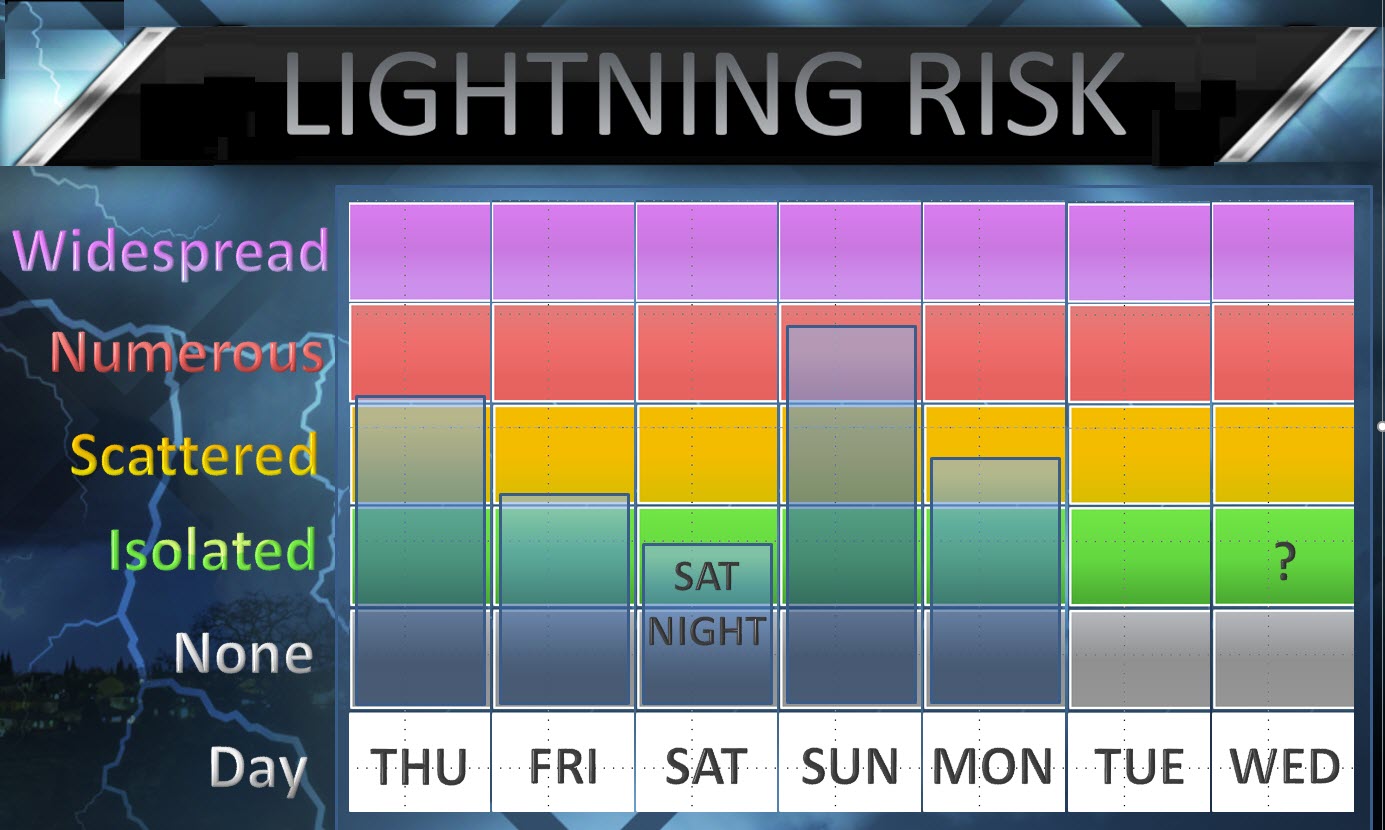
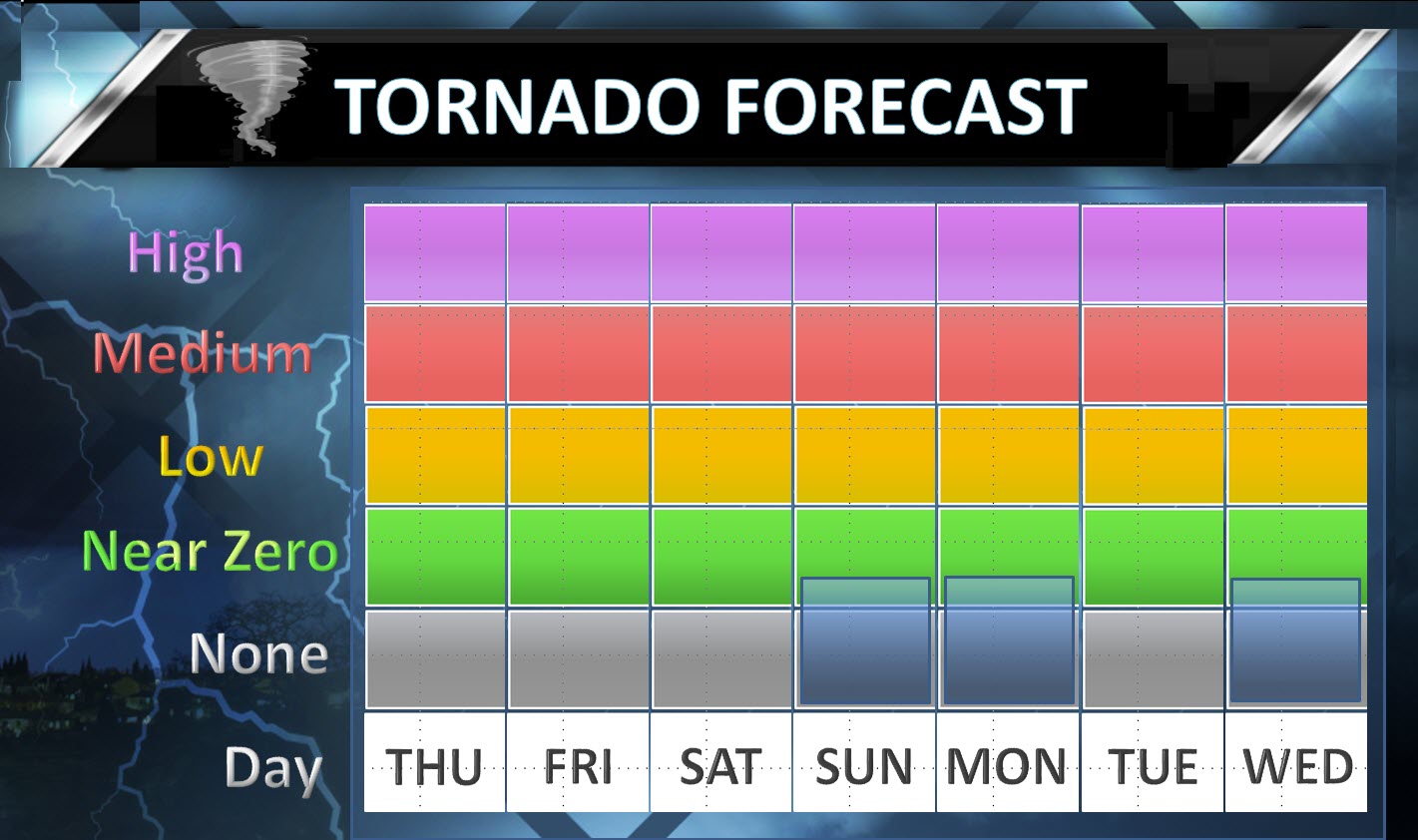
Near zero tornado risk over the coming days.
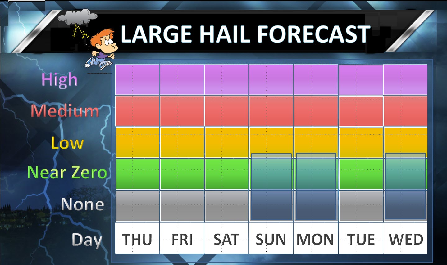
None to almost a low risk for large hail. Not anticipating large hail.

August 3rd and 4th
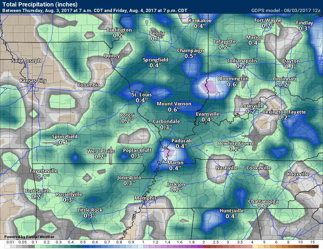
A cold front will push through the region on Thursday night and Friday morning. A broken band of showers and thunderstorms will accompany the front.
Some areas will receive no measurable rainfall. Unfortunately, that seems to be the theme over the past thirty days. Other areas will pick up 0.25″ to 0.50″. Thunderstorms can always produce locally higher totals.
The front should exit the region by the mid or late morning hours on Friday. This will shut down the rain chances. We may still have lingering showers and thunderstorms, especially over our eastern counties, on Friday morning.
By Friday afternoon the area will see sunshine and cooler temperatures. Dew points will also fall to comfortable levels.
Friday night and Saturday will be nice. Cool at night. Mild during the day. The current thinking is that it should be dry through Saturday morning and most likely afternoon. There are some guidance packages that show rain moving into southeast Missouri and southwest Illinois late Saturday afternoon. This will need to be monitored.
Another system will approach from the west on Saturday night. Showers and storms should continue to develop and move eastward through the night.
Shower and thunderstorm chances will increase on Sunday and Sunday night. A few of the storms could produce locally heavy downpours. Severe weather is unlikely.
Rainfall totals from late Saturday into Sunday night will range from 0.30″ to 0.60″. A few areas could top an inch of rain.
Rain chances should dwindle on Monday and Monday night. I did include isolated to perhaps scattered storms on Monday. That would mainly be over our southern counties (near KY/TN border). Elsewhere, small chances for precipitation.
Tuesday and Tuesday night should be dry. I am monitoring another system around next Wednesday/Thursday. Low confidence since it is in the long range.
Temperatures over the coming 10 to 15 days will likely average normal to below normal.
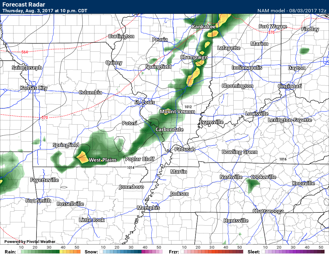
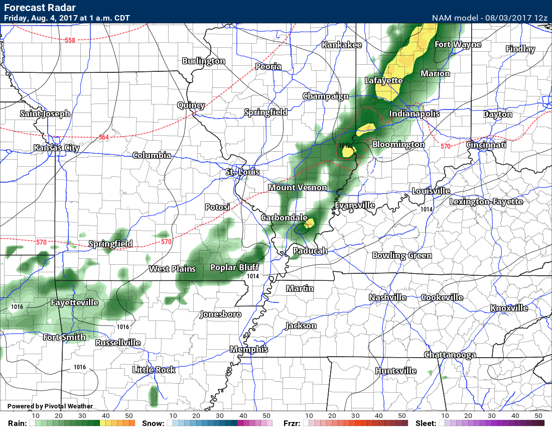
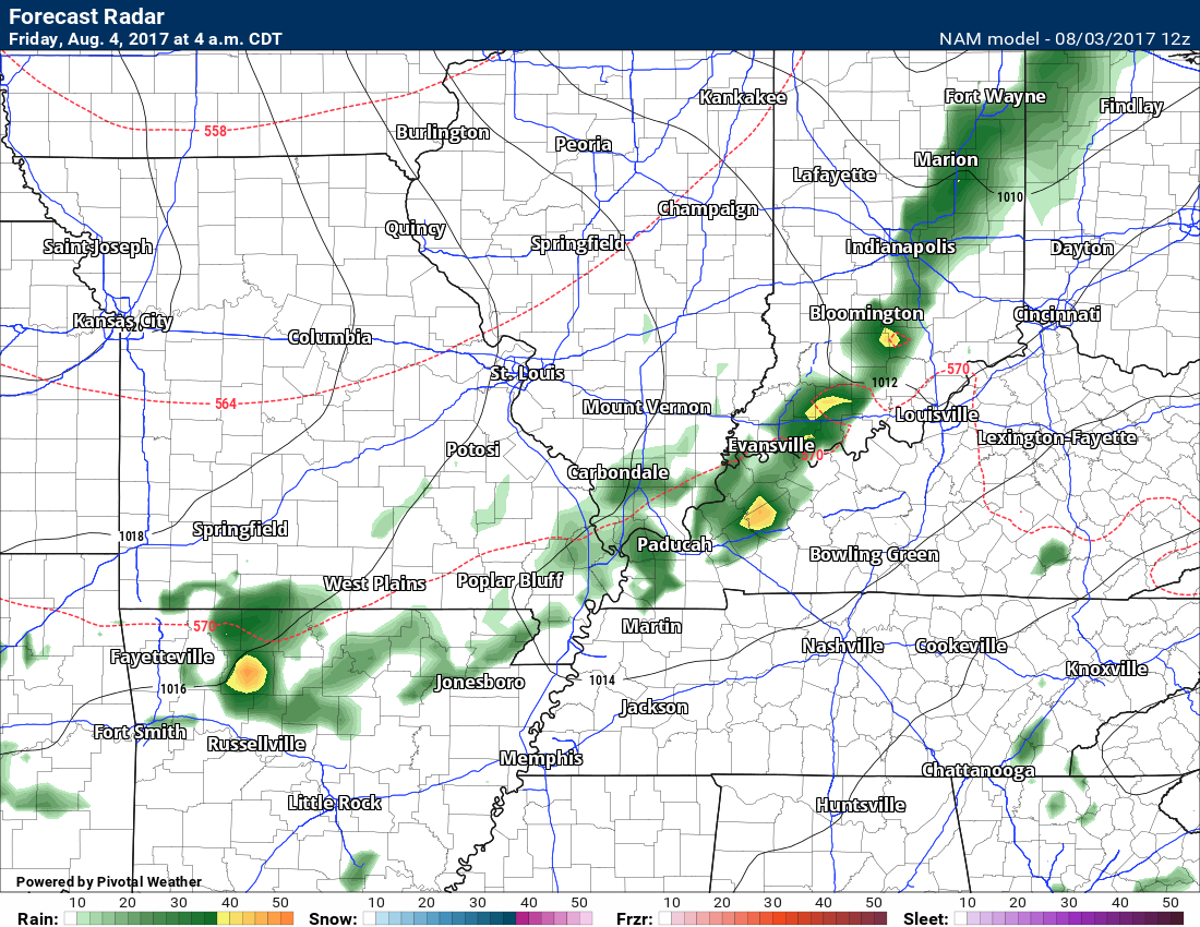
Let’s take a look at future-cast radar
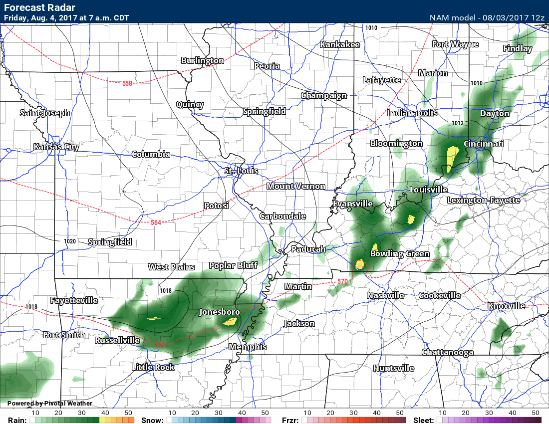
This first image shows the cold front moving through the area late tonight. A band of broken showers along the front. Thunderstorms, as well. Some areas will receive no measurable rainfall.
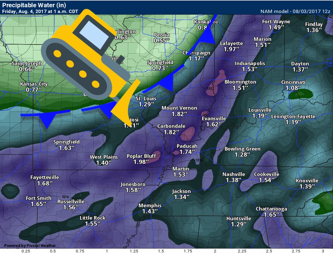
PWAT values tonight will be medium to high. That could mean locally heavy downpours. PWAT is a measure of moisture in the entire atmosphere. Higher numbers mean higher chances for locally heavy rain.
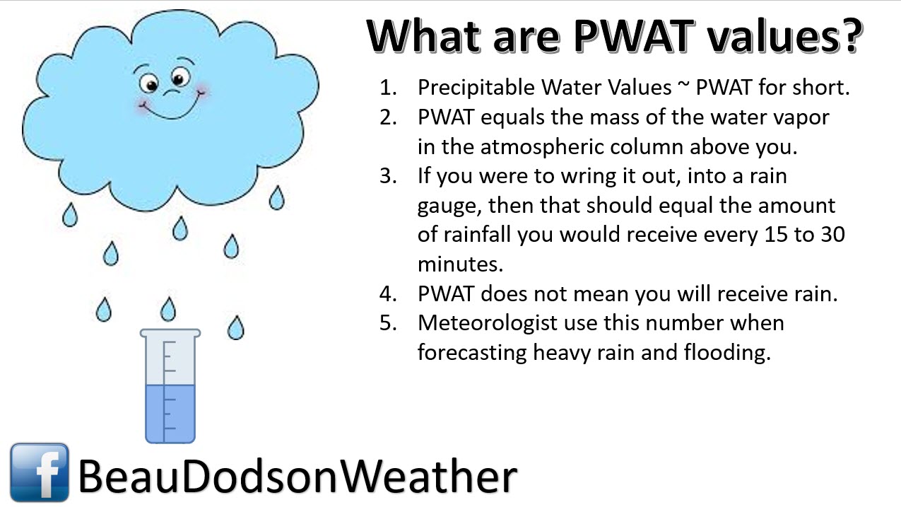
Notice how the PWAT/moisture pools along the incoming cold front? The front acts as a bulldozer pushing the warm and moist air ahead of it.
10 PM
1 AM Friday
4 AM Friday
7 AM Friday
10 AM Friday
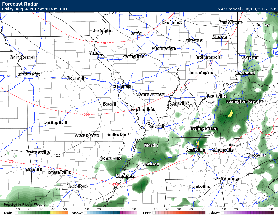
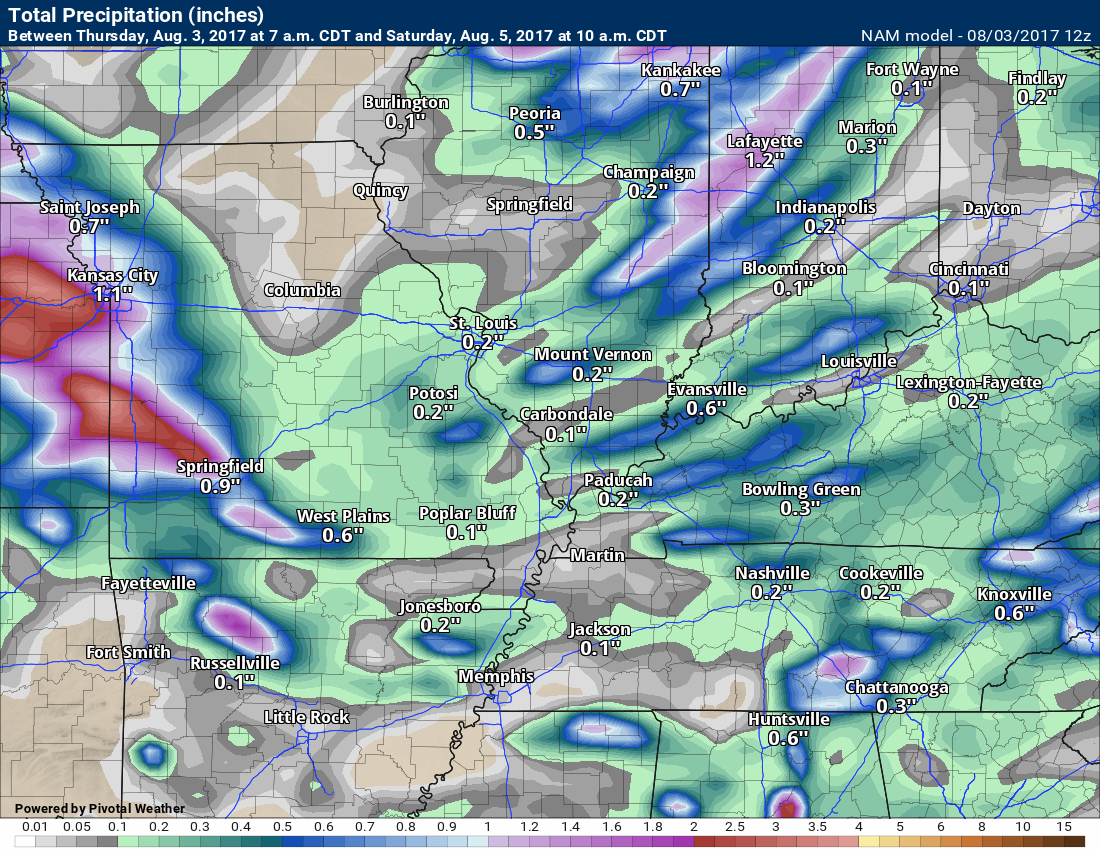
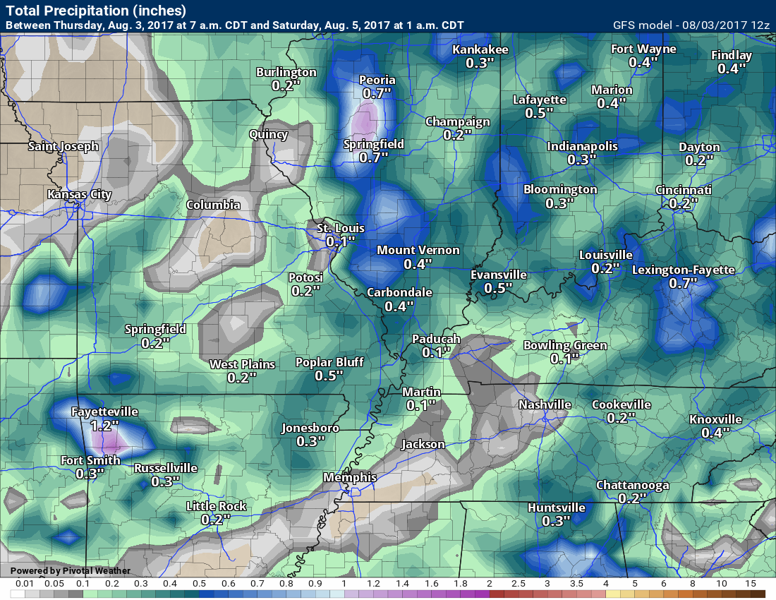
Rainfall totals will range from 0.00 to 0.50″. Thunderstorms can always produce locally higher totals.
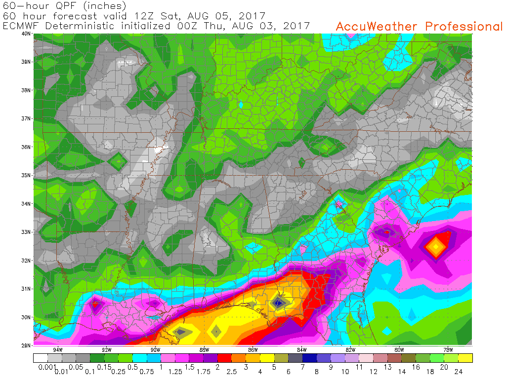
Four models and four rainfall projections. This is only for Thursday night into Friday morning. Again, notice how some areas remain dry.
NAM guidance
GFS guidance
Canadian guidance
EC guidance
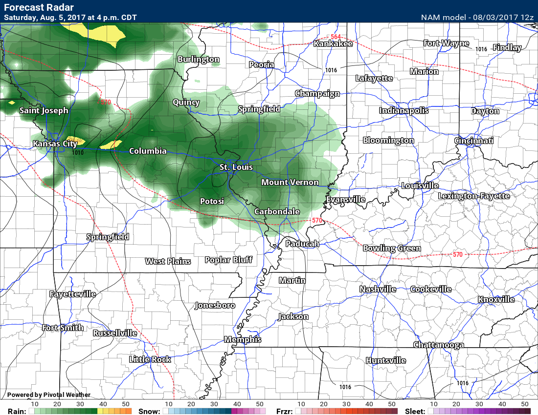
The NAM guidance starts to spread rain back into the area by Saturday evening. Some debate on this. More likely Saturday night into Sunday night.
This is the 4 PM image for Saturday. Obviously the NAM goes hog wild with precipitation returning fast.
For now, I am skeptical about it arriving so soon. Monitor updates.
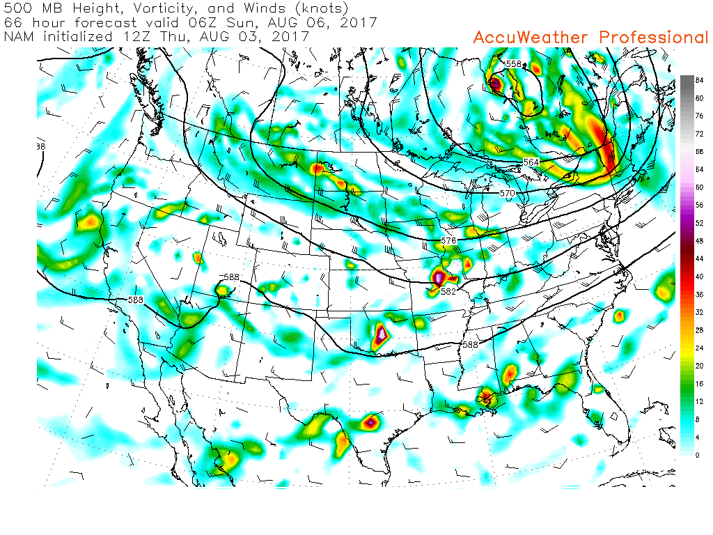
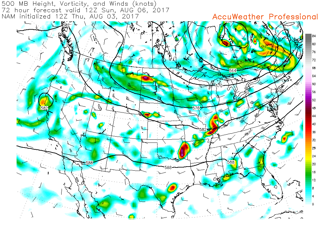
Let’s look at the 500 MB vorticity map. The bright colors represent disturbances moving along the flow of the jet stream. Each one can produce lift and that would mean precipitation.
This is the 1 am map for Sunday. You can see one disturbance in our local area. See it there over eastern Missouri
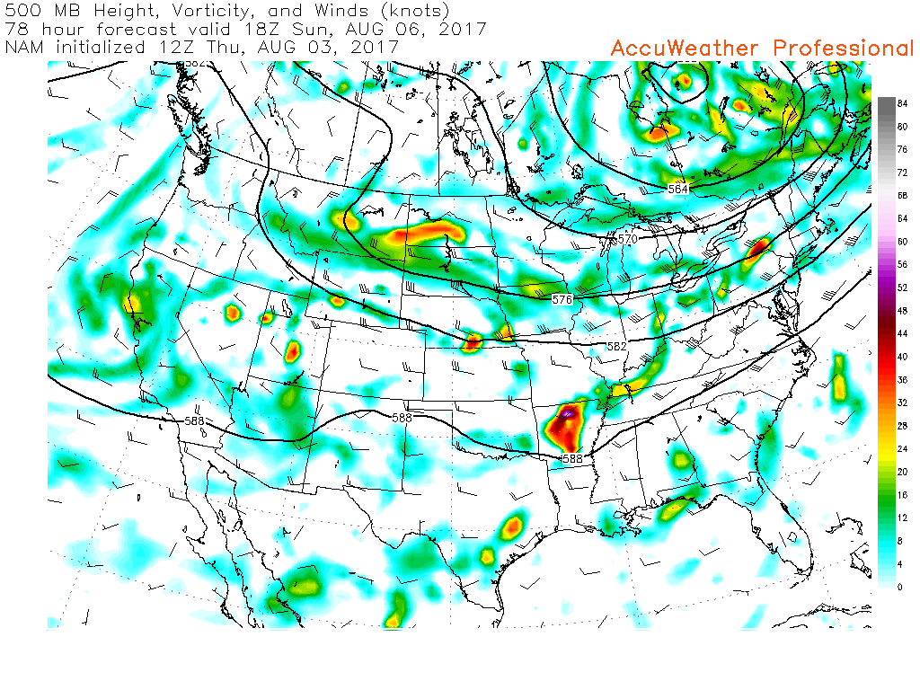
This next map is for 7 am on Sunday
You can see the disturbance moving across our area. Decent shot at rain.
This next map is for 1 pm on Sunday
Notice the wave over Arkansas. That could mean precipitation chances continuing through the day.
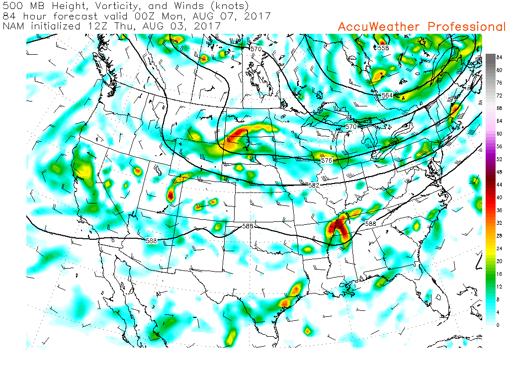
This last map is for 7 pm on Sunday
It shows the vorticity max moving over northeast Arkansas into western Tennessee.
Again, this would mean precipitation chances in our local area.
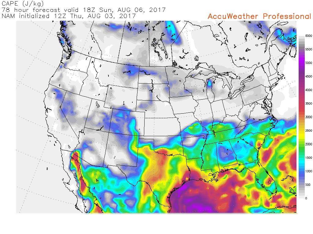
The NAM guidance does show some CAPE on Sunday. CAPE is basically energy for thunderstorms. The higher the CAPE the greater the risk for severe or strong storms. CAPE is not all that great on Sunday, but sufficient for lightning and perhaps gusty winds.
Are you subscribing to the Weather Talk texts and videos?
We now have premiere videos for the short and long range forecasts! Make sure you have text option four turned on (green).
Sign up at www.beaudodsonweather.com
We also have an Apple and Android app (scroll down to bottom of the page for more information)

Were you aware that I have hired some help for long range videos? Short range videos, as well. An amazing team of meteorologists.
Click the link below to read more
http://cms.weathertalk.com/meet-the-team/
Weather Talk subscribers now have some of the best short and long range weather videos produced across the eastern United States.
.

Find me on Twitter
.

We have regional radars and local city radars – if a radar does not update then try another one. Occasional browsers need their cache cleared. You may also try restarting your browser. That usually fixes the problem. Occasionally we do have a radar go down. That is why I have duplicates. Thus, if one fails then try another one.
During the winter you can track snow and ice by clicking the winterize button on the local city view interactive radars.
If you have any problems then please send me an email beaudodson@usawx.com
Interactive Weather Radar Page. Choose the city nearest your location: Click this link—
National interactive radar: Click this link.
Local interactive city radars include St Louis, Mt Vernon, Evansville, Poplar Bluff, Cape Girardeau, Marion, Paducah, Hopkinsville, Memphis, Nashville, Dyersburg, and all of eastern Kentucky. These are interactive radars. Local city radars – click here
The Beau Dodson Weather APP is ready for Apple and Android users. The purpose of this app is for me to deliver your text messages instantly. ATT and Verizon have not always been reliable when it comes to speed. The app allows instant delivery.
Some of you have asked if you can keep receiving the texts on your phone and the app. The answer to that is, yes. The Android app will automatically allow that to happen. On the Apple app, however, you will need to go into your app and click settings. Make sure the green tab is OFF. Off means you will still receive the texts to your phone and the app. If you have any questions, then email me at beaudodson@usawx.com
The app is for text subscribers.
The direct download, for the Apple app, can be viewed here
https://itunes.apple.com/us/app/id1190136514
If you have not signed up for the texting service then you may do so at www.beaudodsonweather.com

The Android app is also ready.
Remember, the app’s are for www.weathertalk.com subscribers. The app allows your to receive the text messages faster than ATT and Verizon.
Here is the download link for the Android version Click Here

——————————————————–
If you have not signed up for the texts messages, then please do. Link www.beaudodsonweather.com
Your support helps with the following:

and


Who do you trust for your weather information and who holds them accountable?
I have studied weather in our region since the late 1970’s. I have 39 years of experience in observing our regions weather patterns. My degree is in Broadcast Meteorology and a Bachelor’s of Science.
My resume includes:
Member of the American Meteorological Society.
NOAA Weather-Ready Nation Ambassador.
Meteorologist for McCracken County Emergency Management. I served from 2005 through 2015.
Meteorologist for McCracken County Rescue. 2015 through current
I own and operate the Southern Illinois Weather Observatory.
I am the chief meteorologist for Weather Talk LLC. I am the owner of Weather Talk LLC.
I am also a business owner in western Kentucky.
Recipient of the Mark Trail Award, WPSD Six Who Make A Difference Award, Kentucky Colonel, and the Caesar J. Fiamma” Award from the American Red Cross.
In 2005 I helped open the largest American Cross shelter in U.S. history in Houston, Texas. I was deployed to help after Hurricane Katrina and Hurricane Rita. I was a shelter manager of one of the Houston, Texas shelter divisions.
In 2009 I was presented with the Kentucky Office of Highway Safety Award.
Recognized by the Kentucky House of Representatives for my service to the State of Kentucky leading up to several winter storms and severe weather outbreaks.
If you click on the image below you can read the Kentucky House of Representatives Resolution.

I am also President of the Shadow Angel Foundation which serves portions of western Kentucky and southern Illinois.
There is a lot of noise on the internet. A lot of weather maps are posted without explanation. Over time you should learn who to trust for your weather information.
My forecast philosophy is simple and straight forward.
- Communicate in simple terms
- To be as accurate as possible within a reasonable time frame before an event
- Interact with you on Twitter, Facebook, email, texts, and this blog
- Minimize the “hype” that you might see on some television stations or through other weather sources
- Push you towards utilizing wall-to-wall LOCAL TV coverage during severe weather events
Many of the graphics on this page are from www.weatherbell.com
WeatherBell is a great resource for weather model guidance.


You can sign up for my AWARE email by clicking here I typically send out AWARE emails before severe weather, winter storms, or other active weather situations. I do not email watches or warnings. The emails are a basic “heads up” concerning incoming weather conditions