October 4, 2017
SUBSCRIBERS: The October and November outlooks have been posted on the subscription site. You can find those under the severe weather tab or live feed on the www.weatherobservatory.com website.
If you have not signed up for the $3 a month (help support all of this) subscription, then visit www.beaudodsonweather.com.
Highlights
1. Yawn weather
2. Above normal temps and below normal precipitation through the weekend
3. Watching a developing tropical system in the Caribbean
4. Two cold fronts will move through our region between Saturday and Tuesday.
A rather benign weather day for the region.
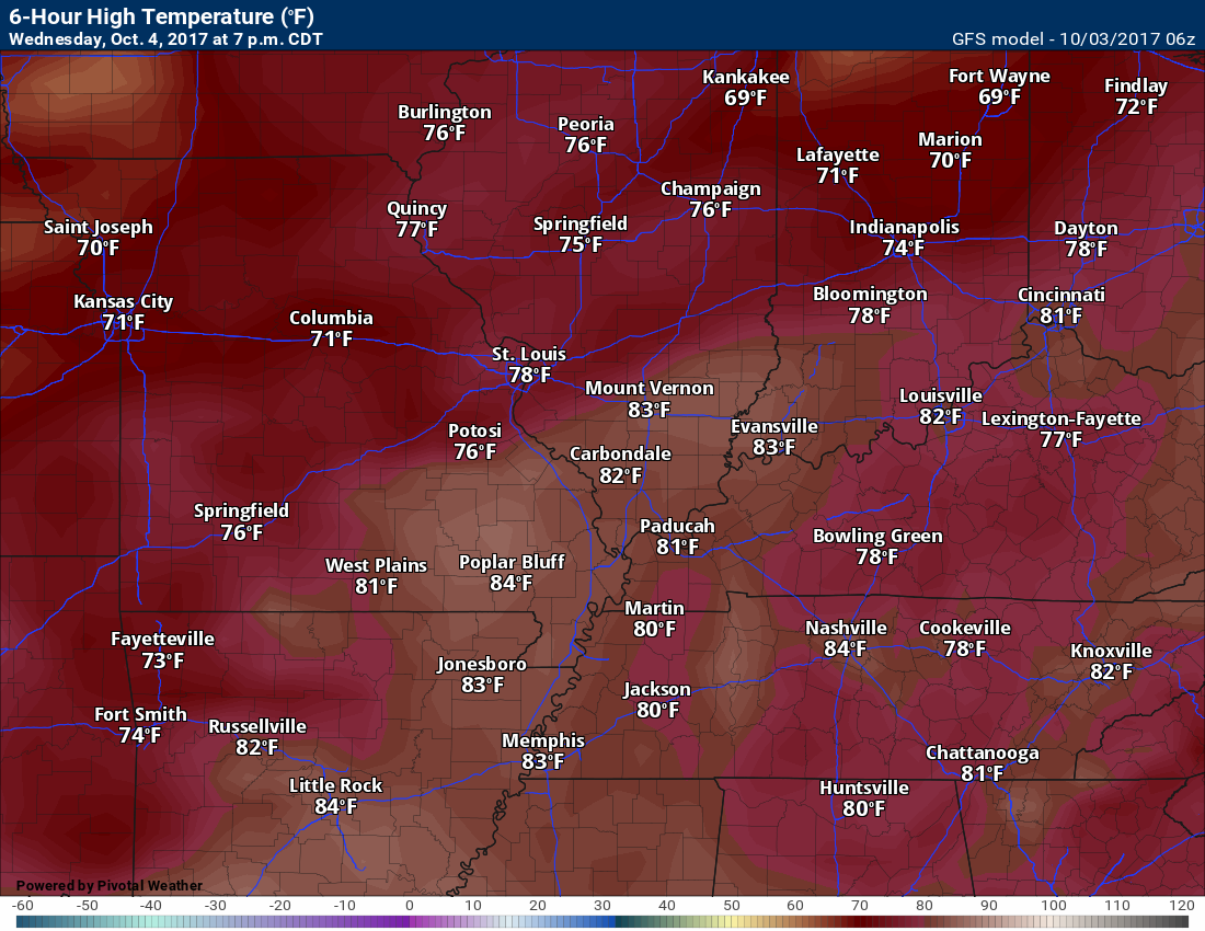
Above normal temperatures today with highs mostly in the lower to middle 80’s.
We do have a band of clouds over portions of southeast Missouri and southern Illinois. A few clouds border that area, as well.
Sun prevails elsewhere. Plenty of sun today (outside of the above mentioned area).
Temperatures will remain above normal on Thursday, Friday, Saturday, Sunday, and Monday.
You can expect daily highs in the 80’s. I am leaning mostly 83 to 86 daily through Sunday. Again, WELL above the normal high temperature of 76 degrees.
Below normal precipitation will be the general rule for the region through Sunday night.
A few showers and thunderstorms can’t be ruled out from Poplar Bluff, MO towards Mt Vernon, IL today and tonight.
Elsewhere, only tiny rain chances for the rest of southeast Missouri and southern Illinois.
I am anticipating dry weather for Kentucky/Tennessee through Sunday.
A weak cold front will push through the area on Saturday. Some clouds, but not much chance for rain.
The Monday night and Tuesday cold front will be somewhat stronger, but questions remain on how much precipitation might fall with it.
If it does not interact with the tropical system (see below), then rain could be spotty. I am monitoring trends.
I am monitoring a tropical system that could spread at least clouds into our region later this weekend into early next week.
At this time, the system should track far enough south and east to keep rain out of the forecast.
With that said, some guidance brings it further west into our region. This is a subject topic that I will have to monitor. Watch for updates over the coming days.


.
A Weather Talk subscription ($3 a month) is required to view the videos.
Videos are posted on the www.weathertalk.com website. Once there, click the Beau Video-Cast tab. Long Range Video Update
If you believe you missed a video then you may check the LIVE FEED link on the Weather Talk website. You will find an archive of videos on that page.
You can also receive the videos via your Weather Talk app/text messages. Have text option FOUR activated. The Weather Extra text option. Sign up for the app/text messages, videos, and more at www.beaudodsonweather.com
.
This forecast covers the counties in red. The counties in orange are covered by the forecast discussion further down in the blog.


.
October 3, 2017
Tuesday Night Forecast Details:
Forecast: Partly cloudy and mild. Isolated shower chance over southeast Missouri and southern Illinois. Most areas will remain dry.
Temperatures: MO ~ 60 to 65 IL ~ 60 to 65 KY ~ 60 to 65 TN ~60 to 65
Winds: South at 6 to 12 mph. Winds may gust above 15 mph.
What impacts are anticipated from the weather? Isolated shower chances for southeast Missouri and southern Illinois. Most areas will remain dry.
My confidence in the forecast verifying: Medium
Is severe weather expected? No
The NWS defines severe weather as 58 mph winds or great, 1″ hail or larger, and/or tornadoes
What is the chance of precipitation? MO ~ 20% IL ~ 30% KY ~ 10% TN ~ 10%
Coverage of precipitation: None to isolated.
Should I cancel my outdoor plans? No
.
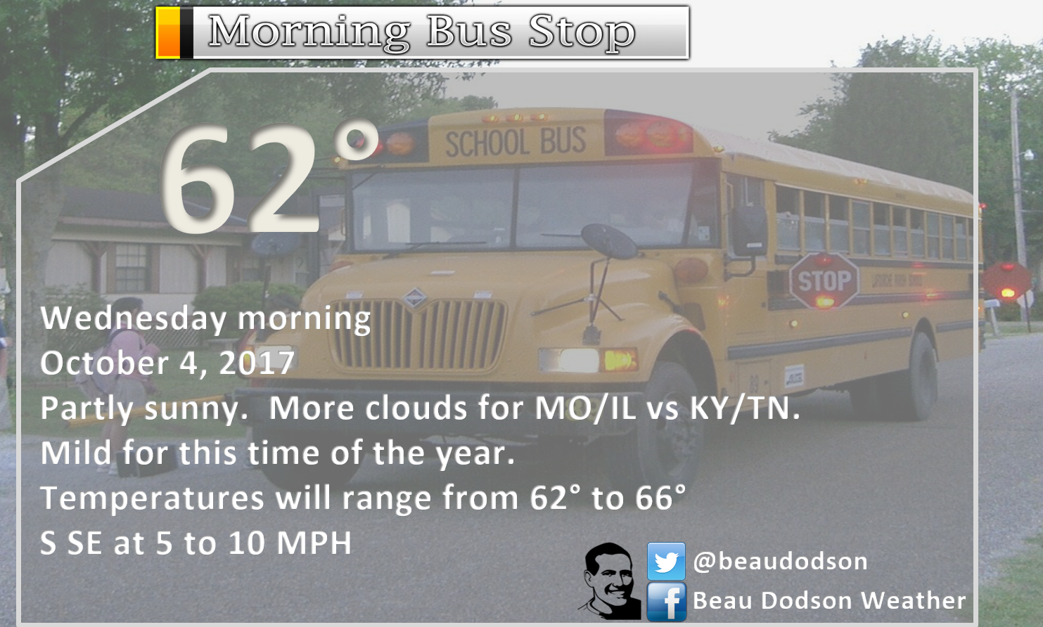
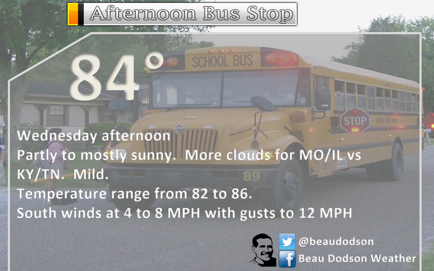
October 4, 2017
Wednesday Forecast Details
Forecast: A few clouds. warm. An isolated shower or thunderstorm for southeast Missouri and southern Illinois. Most areas will remain dry.
Temperatures: MO ~ 82 to 86 IL ~82 to 86 KY ~ 82 to 86 TN ~ 82 to 86
Winds: South and southwest at 5 to 10 mph with gusts to 14 mph
What impacts are anticipated from the weather? Most likely none. I will be monitoring southeast Missouri and southern Illinois for shower chances. For now, I kept them at 20% or less.
My confidence in the forecast verifying: Medium
Is severe weather expected? No
The NWS defines severe weather as 58 mph winds or great, 1″ hail or larger, and/or tornadoes
What is the chance of precipitation? MO ~ 20% IL ~ 20% KY ~ 0% TN ~ 0%
Coverage of precipitation: None to isolated
Should I cancel my outdoor plans? No
.
Wednesday Night Forecast Details:
Forecast: Partly cloudy. Mild. Well above normal temperatures.
Temperatures: MO ~62 to 66 IL ~ 62 to 66 KY ~ 62 to 66
Winds: South and southwest at 0 to 6 mph
What impacts are anticipated from the weather? Most likely none.
My confidence in the forecast verifying: High
Is severe weather expected? No
The NWS defines severe weather as 58 mph winds or great, 1″ hail or larger, and/or tornadoes
What is the chance of precipitation? MO ~ 10% IL ~ 10% KY ~ 0%
Coverage of precipitation: Most likely none.
Should I cancel my outdoor plans? No
.
SUBSCRIBERS: The October and November outlooks have been posted on the subscription site. You can find those under the severe weather tab or live feed on the www.weatherobservatory.com website.
If you have not signed up for the $3 a month (help support all of this) subscription, then visit www.beaudodsonweather.com. Normal operating costs, for all of this data, is more than $2000 a month.
.
October 5, 2017
Thursday Forecast Details
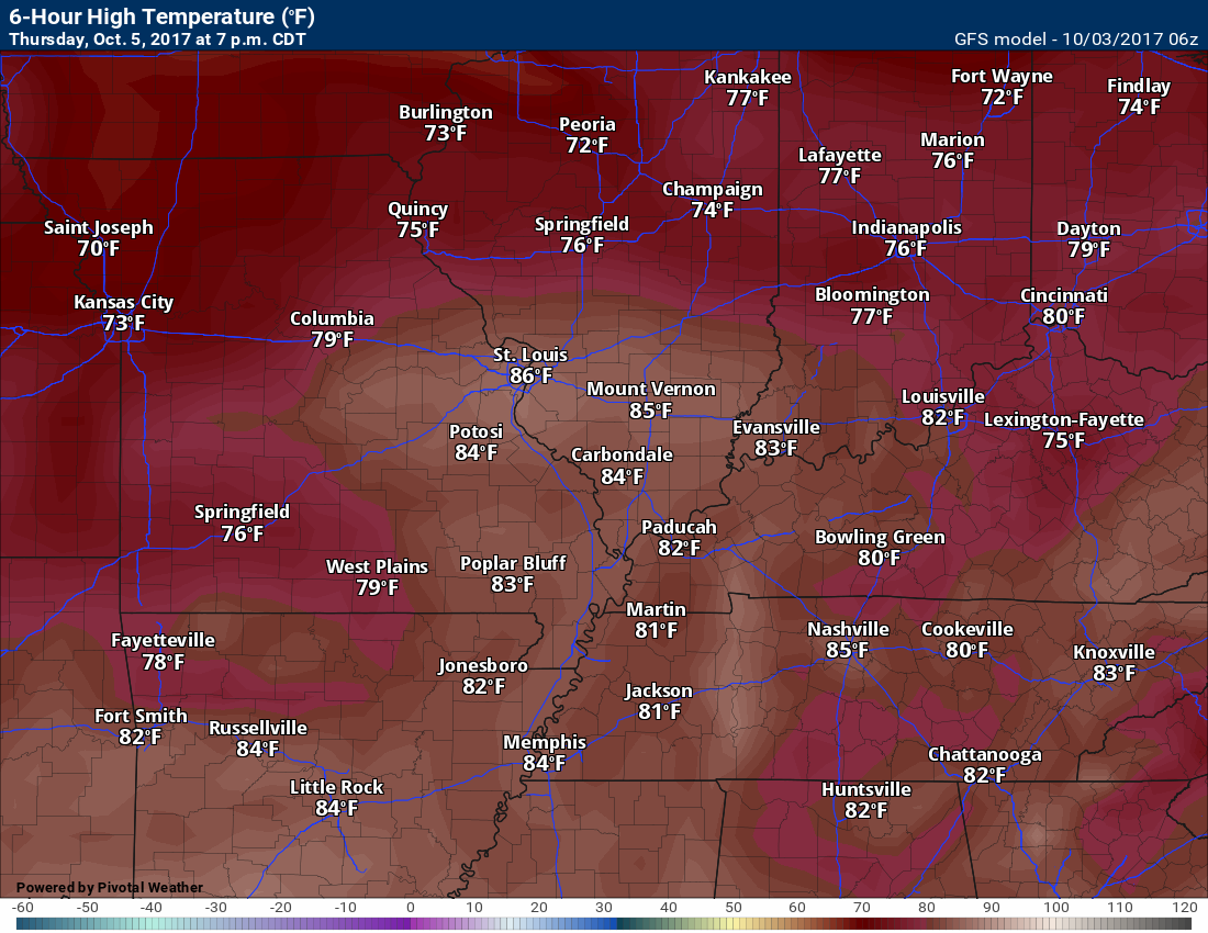
Forecast: A mix of sun and clouds. Very warm for October. Well above normal temperatures.
Temperatures: MO ~ 83 to 86 IL ~83 to 86 KY ~ 83 to 86
Winds: South and southwest at 5 to 10 mph
What impacts are anticipated from the weather? Most likely none.
My confidence in the forecast verifying: High
Is severe weather expected? No
The NWS defines severe weather as 58 mph winds or great, 1″ hail or larger, and/or tornadoes
What is the chance of precipitation? MO ~ 10% IL ~ 10% KY ~ 0%
Coverage of precipitation: Most likely none.
Should I cancel my outdoor plans? No
.
Thursday Night Forecast Details:
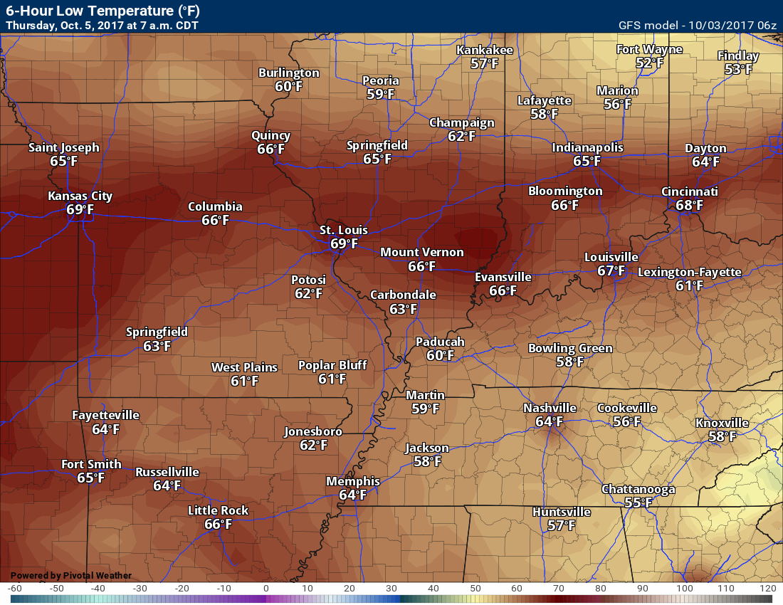
Forecast: Partly cloudy. Mild for October. Well above normal temperatures.
Temperatures: MO ~ 60 to 64 IL ~ 60 to 64 KY ~ 60 to 64
Winds: South at 4 to 8 mph
What impacts are anticipated from the weather? Most likely none
My confidence in the forecast verifying: Medium
Is severe weather expected? No
The NWS defines severe weather as 58 mph winds or great, 1″ hail or larger, and/or tornadoes
What is the chance of precipitation? MO ~ 10% IL ~ 10% KY ~ 5%
Coverage of precipitation: Most likely none.
Should I cancel my outdoor plans? No
.
October 6, 2017
Friday Forecast Details
Forecast: Partly sunny. Very warm for October. Well above normal temperatures.
Temperatures: MO ~ 84 to 88 IL ~84 to 88 KY ~ 84 to 88
Winds: South and southwest at 5 to 10 mph with gusts to 15 mph
What impacts are anticipated from the weather? Most likely none.
My confidence in the forecast verifying: Medium
Is severe weather expected? No
The NWS defines severe weather as 58 mph winds or great, 1″ hail or larger, and/or tornadoes
What is the chance of precipitation? MO ~ 10% IL ~ 10% KY ~ 10%
Coverage of precipitation: Most likely none
Should I cancel my outdoor plans? No
.
Friday Night Forecast Details:
Forecast: Increasing clouds. Well above normal temperatures. For now, I will keep Friday night dry in my forecast counties. Monitor updates.
Temperatures: MO ~ 62 to 66 IL ~ 62 to 66 KY ~ 62 to 66
Winds: South at 5 to 10 mph with gusts to 20 mph. Gusty winds possible.
What impacts are anticipated from the weather? Late at night there could be a few showers/storms approaching from the northwest.
My confidence in the forecast verifying: Medium
Is severe weather expected? No
The NWS defines severe weather as 58 mph winds or great, 1″ hail or larger, and/or tornadoes
What is the chance of precipitation? MO ~ 20% IL ~ 20% KY ~ 10%
Coverage of precipitation: Most likely none. I will be monitoring my Missouri and Illinois forecast counties.
Should I cancel my outdoor plans? Check updates and radars
.
October 7, 2017
Saturday Forecast Details
Forecast: A mix of sun and clouds. A 20% to 30% for showers and thunderstorms. Very warm for October. Well above normal temperatures.
Temperatures: MO ~ 83 to 86 IL ~83 to 86 KY ~ 83 to 86
Winds: South and southwest winds becoming variable at 15 to 25 mph. Gusty winds possible.
What impacts are anticipated from the weather? Wet roadways. Perhaps lightning.
My confidence in the forecast verifying: Low
Is severe weather expected? No
The NWS defines severe weather as 58 mph winds or great, 1″ hail or larger, and/or tornadoes
What is the chance of precipitation? MO ~ 30% IL ~ 30% KY ~ 20%
Coverage of precipitation: Widely scattered
Should I cancel my outdoor plans? Monitor updates.
.
Saturday Night Forecast Details:
Forecast: Partly cloudy with a slight chance for a shower or thunderstorm. A little cooler, but still above normal temperatures.
Temperatures: MO ~ 58 to 62 IL ~ 58 to 62 KY ~ 58 to 62
Winds: Variable at 5 to 10 mph with gusts to 14 mph.
What impacts are anticipated from the weather? Wet roadways and perhaps lightning.
My confidence in the forecast verifying: Low
Is severe weather expected? No
The NWS defines severe weather as 58 mph winds or great, 1″ hail or larger, and/or tornadoes
What is the chance of precipitation? MO ~ 10% IL ~ 20% KY ~ 20%
Coverage of precipitation: Isolated.
Should I cancel my outdoor plans? Check radars. Check updates.
.
October 8, 2017
Sunday Forecast Details
Forecast: Partly sunny and warm. Isolated thunderstorms possible. This will need to be monitored. Tropical moisture moving northward from the Gulf of Mexico could mean a few showers/storms. Low confidence. Well above normal temperatures.
Temperatures: MO ~ 84 to 86 IL ~83 to 86 KY ~ 84 to 86
Winds: Variable winds at 6 to 12 mph with gusts to 15 mph
What impacts are anticipated from the weather? Perhaps some wet roadways and lightning.
My confidence in the forecast verifying: Medium
Is severe weather expected? Not at this time
The NWS defines severe weather as 58 mph winds or great, 1″ hail or larger, and/or tornadoes
What is the chance of precipitation? MO ~ 10% IL ~ 10% KY ~ 20%
Coverage of precipitation: Isolated
Should I cancel my outdoor plans? Check radars and updates.
.
Sunday Night Forecast Details:
Forecast: Partly cloudy. Mild. Isolated thunderstorms possible. Well above normal temperatures.
Temperatures: MO ~ 60 to 65 IL ~ 60 to 65 KY ~ 60 to 65
Winds: South and southeast winds at 5 to 10 mph with gusts to 14 mph.
What impacts are anticipated from the weather? Perhaps some wet roadways and lightning.
My confidence in the forecast verifying: Low
Is severe weather expected? No
The NWS defines severe weather as 58 mph winds or great, 1″ hail or larger, and/or tornadoes
What is the chance of precipitation? MO ~ 10% IL ~ 10% KY ~ 20%
Coverage of precipitation: Isolated, but monitor updates
Should I cancel my outdoor plans? No, but check back for updated forecasts.
.
October 9, 2017
Monday Forecast Details
Forecast: Partly sunny and warm. I will be monitoring the tropical system to our south and east. Well above normal temperatures will continue.
Temperatures: MO ~ 82 to 86 IL ~82 to 86 KY ~ 82 to 86
Winds: Southerly winds at 6 to 12 mph
What impacts are anticipated from the weather? Monitor updates.
My confidence in the forecast verifying: Medium
Is severe weather expected? Not at this time
The NWS defines severe weather as 58 mph winds or great, 1″ hail or larger, and/or tornadoes
What is the chance of precipitation? MO ~ 10% IL ~ 10% KY ~ 20%
Coverage of precipitation: None to isolated. Low confidence. Check back for updates.
Should I cancel my outdoor plans? Check updates.
.
Monday Night Forecast Details:
Forecast: Increasing clouds. A chance for showers and thunderstorms. A cold front approaches from the northwest. Well above normal temperatures.
Temperatures: MO ~ 60 to 64 IL ~ 60 to 64 KY ~ 60 to 64
Winds: South winds becoming southwest and west at 5 to 10 mph with higher gusts possible.
What impacts are anticipated from the weather? Lightning. Wet roadways possible.
My confidence in the forecast verifying: Low
Is severe weather expected? No
The NWS defines severe weather as 58 mph winds or great, 1″ hail or larger, and/or tornadoes
What is the chance of precipitation? MO ~ 40% IL ~ 40% KY ~ 30%
Coverage of precipitation: Perhaps increasing coverage from the northwest
Should I cancel my outdoor plans? Monitor updates and radars
.
.
.

The National Weather Service definition of a severe thunderstorm is one that produces quarter size hail or larger, 58 mph winds or greater, and/or a tornado.
Tuesday night through Saturday: Severe weather is not anticipated.
A few thunderstorms can’t be ruled out for southeast Missouri and southern Illinois over the coming days. Perhaps the best chance will be Friday night or Saturday as a weak cold front passes through the area.
I am monitoring a stronger cold front on Monday. Too early to know if severe weather is a concern.

Overview
Highlights of the forecast.
- More warm weather
- Drought conditions
- Use care with burning brush and fields
Short range comments
Subscribers, sign into your WeatherTalk account and see the latest October forecast. Click here for that information.
(See the long range discussion further down in this post)
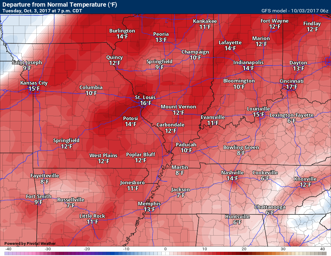
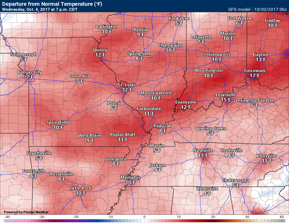
The main weather story, over the coming days, will be the above normal temperatures. What an amazing few weeks it has been. Day after day of above normal temperatures. Some days have been WELL above normal.
Normal high temperatures, for this time of the year, are around 76 degrees.
A weak cold front arrives on Saturday (see the long range discussion further down in this update)
Here was Tuesday’s anomalies
Wednesday forecast anomalies
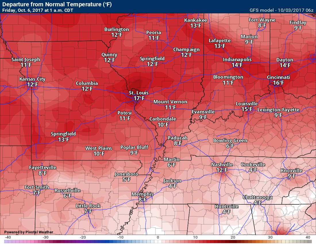
Thursday and Friday forecast anomalies
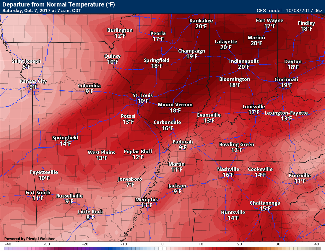
Saturday forecast anomalies.
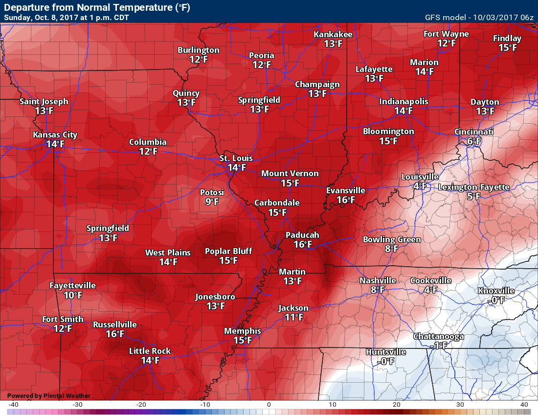
Sunday temperature anomalies
Sunday and Monday will also deliver above normal temperatures. As a matter of fact, some of the guidance shows upper 80’s on Monday.
That general pattern will continue into the weekend.
We will have a mix of sun and clouds through Friday. Small shower and thunderstorm chances. The best chance (30% or less) will be over southeast Missouri and southern Illinois. Less than 20% chance for Kentucky/Tennessee.
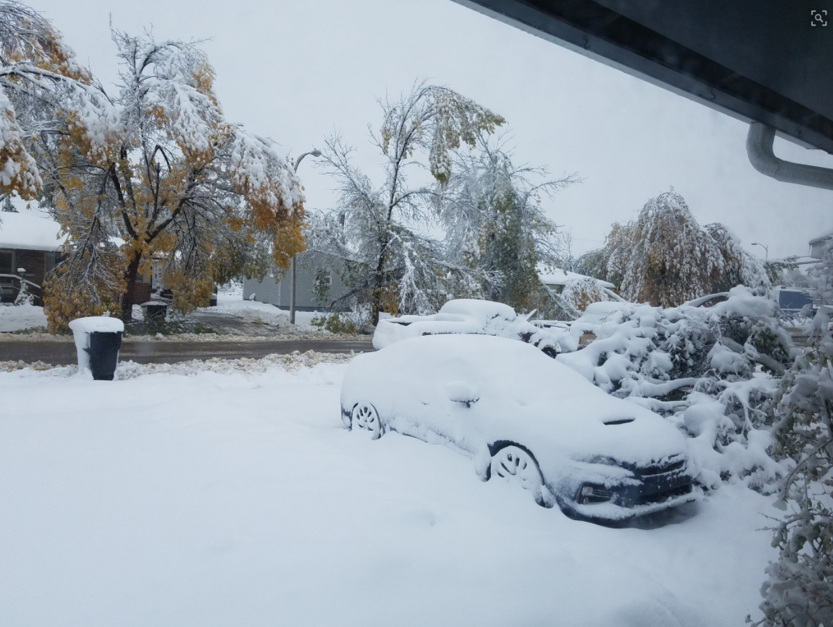
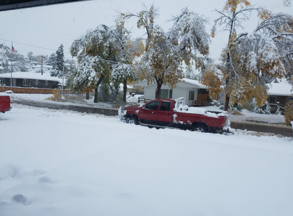
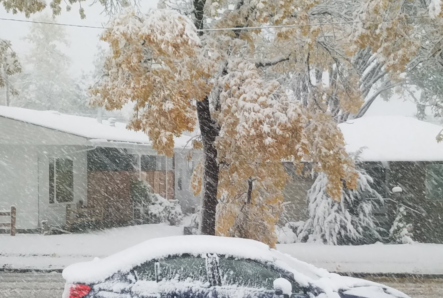
Check out these photographs from Havre, Montana. These photographs were taken by Jasmine, Millier (Twitter feed – click here)
Click image to enlarge
Early season snow event. Leaves are still on the trees.
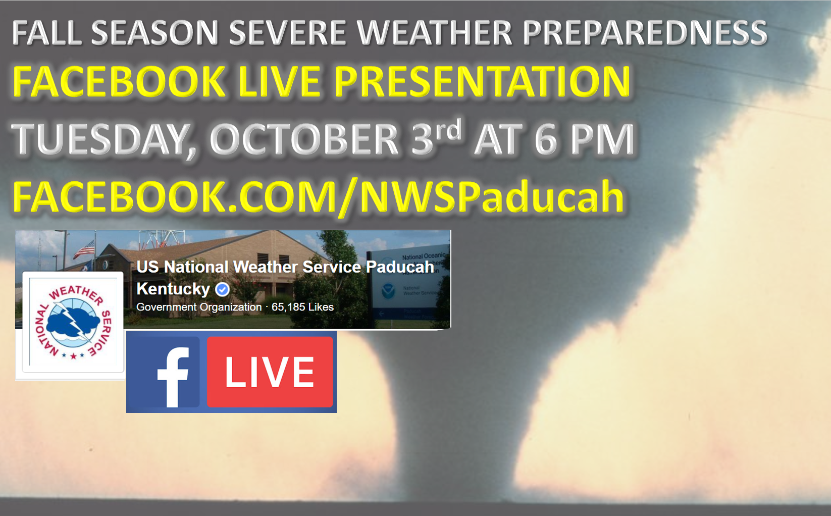
You might want to listen in on this presentation
.
See long range discussion below
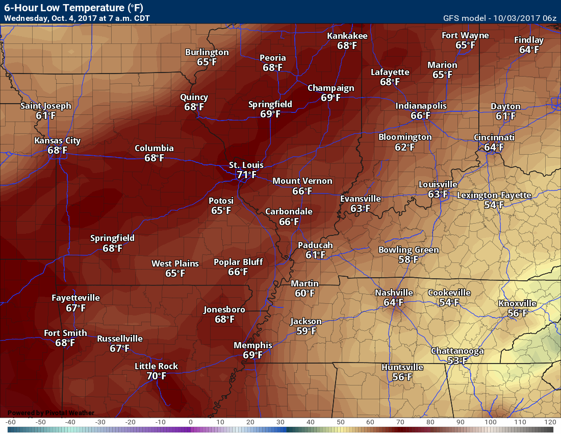
Temperature Forecast
Tuesday night low temperatures
Wednesday high temperatures
Wednesday night low temperatures
Thursday high temperatures
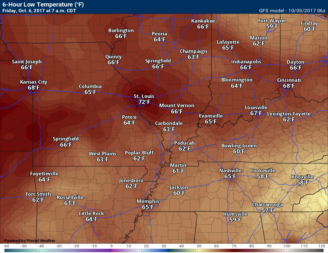
Thursday night low temperatures
Friday high temperatures
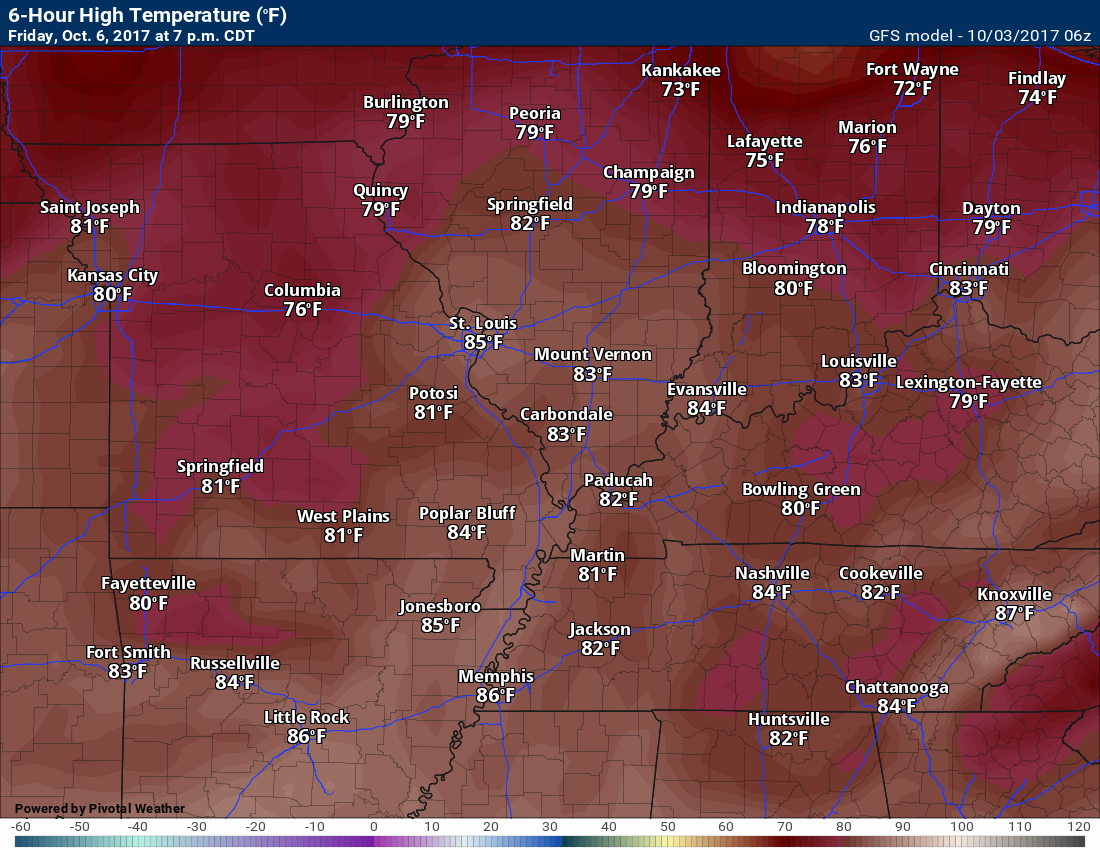
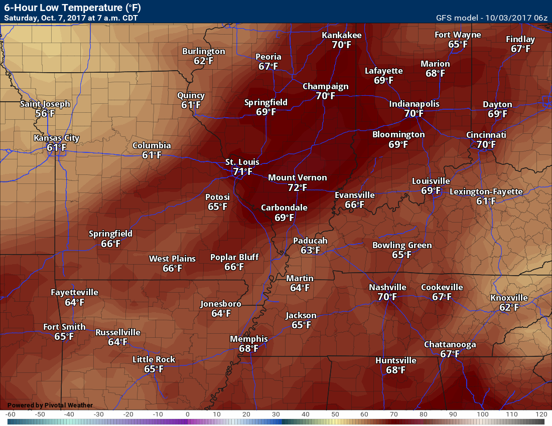
Friday low temperatures
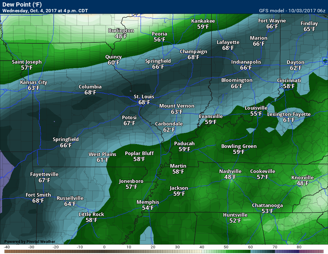
Dew point scale
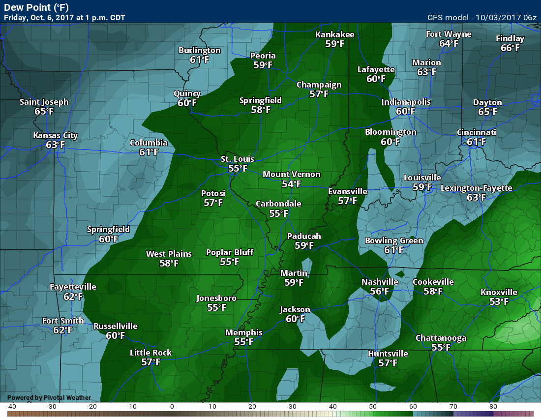
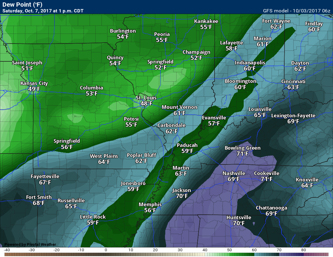
Dew points are what control how you feel outside.

Wednesday dew points
Thursday dew points
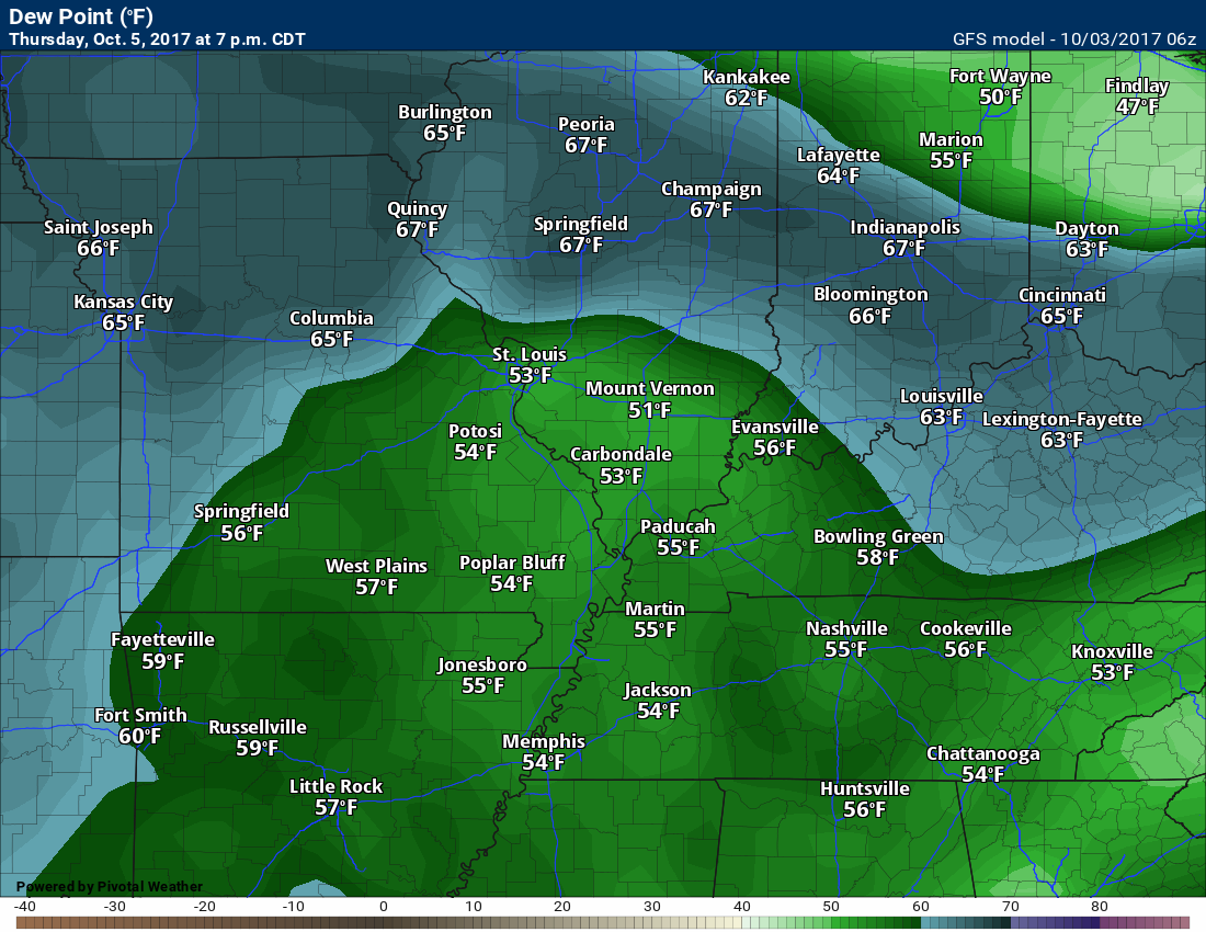
Friday dew points
Saturday dew points
Notice the spike right ahead of the cold front.
Long range forecast discussion
Friday through Tuesday
The main weather story, in the long range, will be the warm temperatures and two cold fronts.
A weakening cold front will push through the region on Saturday. At this time, it appears that a band of showers and thunderstorms will push through Missouri and then weaken as it moves into our local area.
If that is the case, then many areas may end up with little or perhaps no rainfall. Drought conditions will certainly worsen.
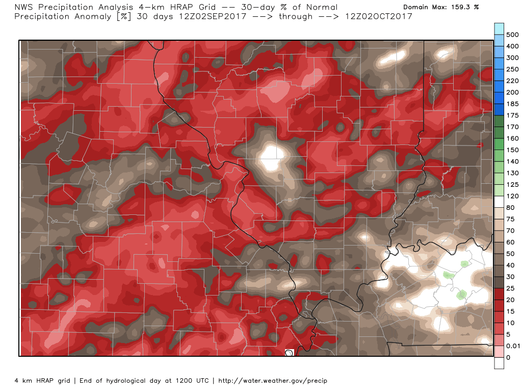
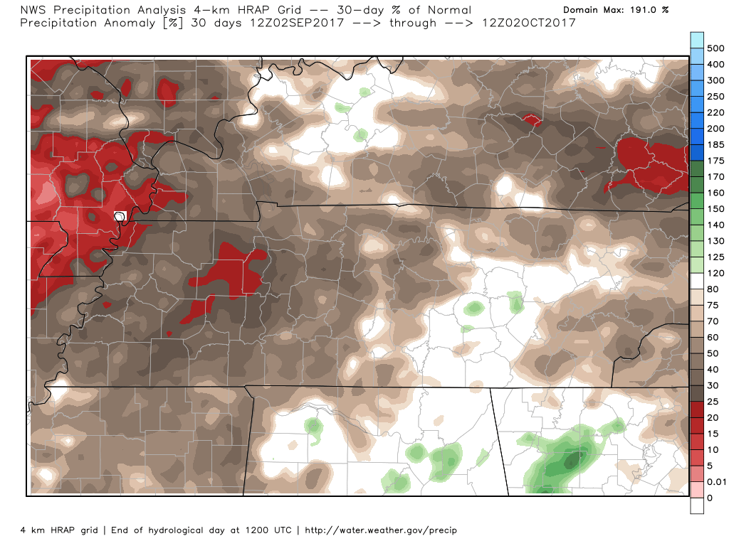
Here is the 30 day percent of normal rainfall. I zoomed in on Missouri and Illinois/Kentucky.
Look at these incredible numbers. Portions of our region of only experienced 10% or less of their normal rainfall totals.
For example: If your normal rainfall, for the thirty day period, is one inch and you received ten percent of your normal rainfall, then you would have received 0.10″ of rain.
Zoomed in on Tennessee
Here is the sixty day deviation from normal rainfall. Portions of our region are negative five inches.
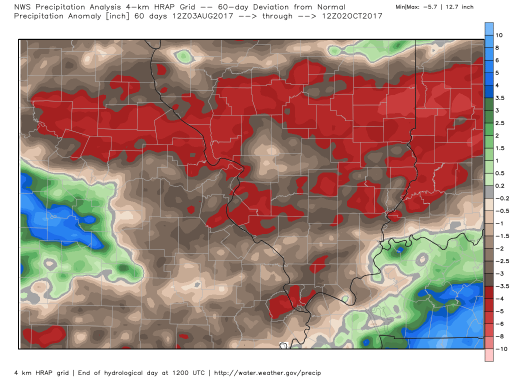
There will be a chance for showers and thunderstorms on Saturday, but don’t get your hopes up. The front will be weakening and precipitation may dry up.
A stronger cold front is anticipated for Monday/Tuesday. The problem with this front is that it is in the long range. I don’t trust model guidance, this time of the year, for days five and six. I will monitor trends.
Models do not handle transition seasons. That means October and November.
The EC guidance is more bullish with this front compared to the GFS model. It shows enough instability for some stronger thunderstorms. The GFS guidance shows the front, but weaker.
This would be our best hope for rainfall. Low confidence this far out.
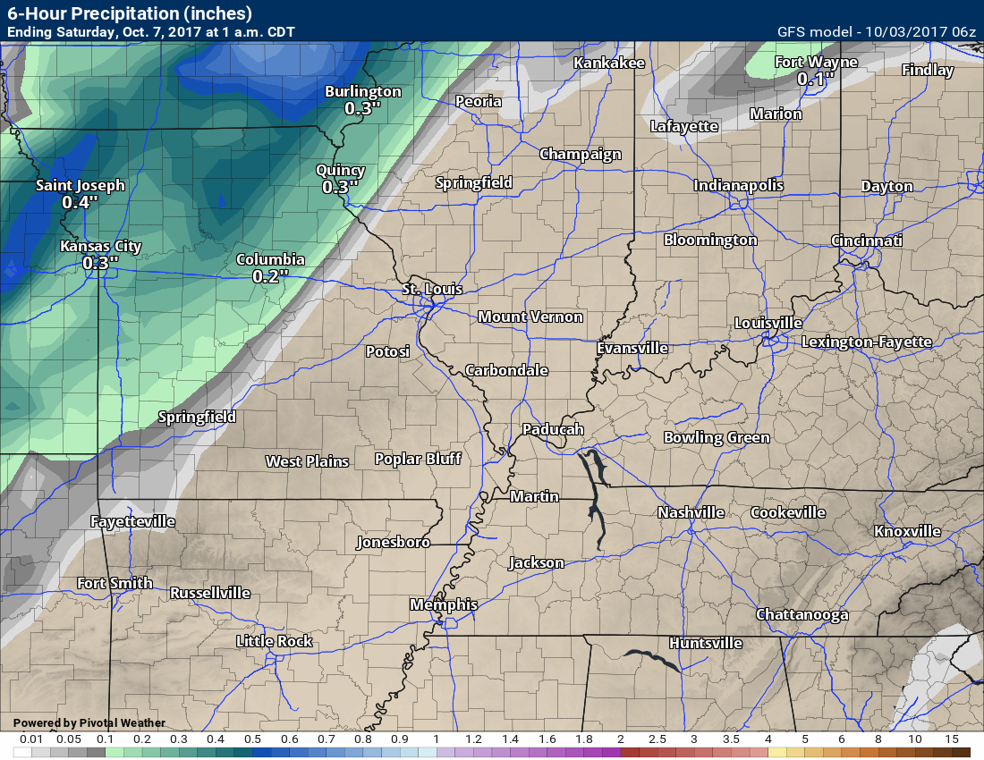
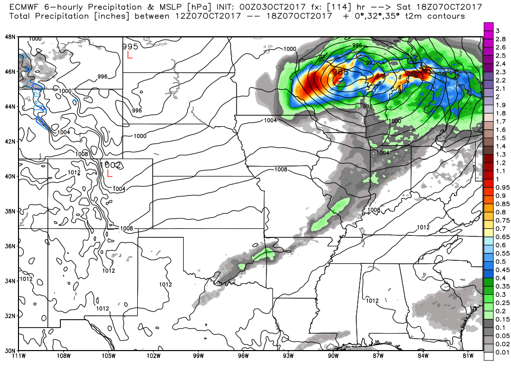
Let me show you a couple of maps.
This first set of maps is for the weakening cold front on Saturday.
This is the GFS model. The colors represent six hour rainfall totals. Watch what happens as it approaches our region.
This first map is for 7 PM Friday through 1 AM on Saturday.
Notice the heavier band of rain to our west/northwest.
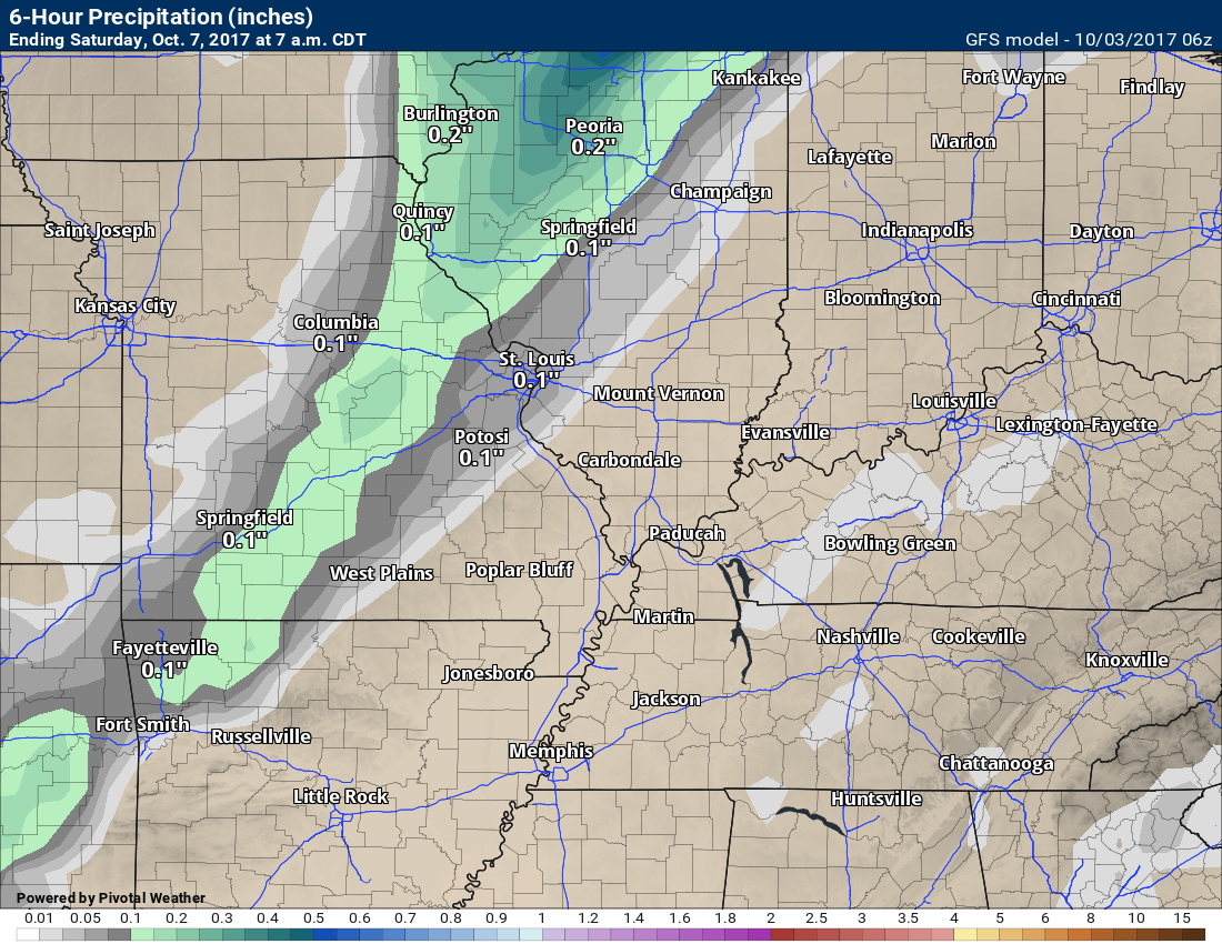
This graphic is from 1 AM Saturday through 7 AM Saturday
Notice what is happening? The rainfall totals are growing small.
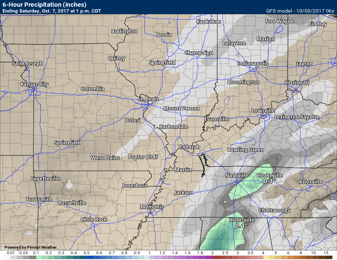
This next map is for 7 AM Saturday through 1 PM on Saturday.
POOF. Most of it is gone. If this holds, then we see little or no rainfall from the front.
Here is the EC guidance. You can see the colors through our region. Those colors represent light rain totals for Saturday morning and early afternoon. The EC guidance also indicates little in the way of measurable rainfall for our region.
Are you subscribing to Weather Talk app/text messages and videos? This is what helps support all of the data you see each day.
We now offer premium videos for the short and long range forecasts! These videos are produced by a team of long range forecast experts. They are brought to you as bonus information. Activate text option four in order to receive these on your app or via text.
Subscribe at www.beaudodsonweather.com
We offer an Apple and Android app (scroll to the bottom of this page for more information).

Were you aware that I hired a team of meteorologists for long range videos?
To learn more, click this link
http://cms.weathertalk.com/meet-the-team/
.


We offer regional radars and local city radars – if a radar does not update then try another one. Occasional browsers need their cache cleared. You may also try restarting your browser. This will usually fix any problems.
During the winter you can track snow and ice by clicking the winterize button on the local city view interactive radars.
You may email me at beaudodson@usawx.com
Interactive Weather Radar Page. Choose the city nearest your location: Click this link
National interactive radar: Click this link.
The Beau Dodson Weather APP is ready for Apple and Android users. The app provides a faster way for you to receive my text messages. ATT and Verizon are not always reliable when it comes to speed.
Some of you have asked if you can receive the texts on your phone and the app. The answer to that is, yes. The Android app will automatically allow that to happen. On the Apple app, however, you will need to open your app and click the settings button. Make sure the green tab is OFF. Off means you will still receive the texts to your phone and the app. If you have any questions, then email me at beaudodson@usawx.com
The app is for text subscribers.
The direct download, for the Apple app, can be viewed here
https://itunes.apple.com/us/app/id1190136514
Here is the download link for the Android version Click Here
If you have not signed up for the texting service then you may do so at www.beaudodsonweather.com


——————————————————–
Your support helps with the following:

and

.

Whom do you trust for your weather information?
I have studied weather, in our region, since the late 1970’s. I have 40 years of experience in observing our regions weather patterns. My degree is in Broadcast Meteorology and a Bachelor’s of Science.
My resume includes:
Member of the American Meteorological Society.
NOAA Weather-Ready Nation Ambassador.
Meteorologist for McCracken County Emergency Management. I served from 2005 through 2015.
Meteorologist for McCracken County Rescue. 2015 through current
I own and operate the Southern Illinois Weather Observatory.
I am the chief meteorologist for Weather Talk LLC.
I am also a business owner in western Kentucky.
Recipient of the Mark Trail Award, WPSD Six Who Make A Difference Award, Kentucky Colonel, and the Caesar J. Fiamma” Award from the American Red Cross.
In 2005, I helped open the largest American Cross shelter in U.S. history. This was in Houston, Texas. I was deployed to help with the aftermath of Hurricane Katrina and Hurricane Rita. I was a shelter manager of one of the Houston, Texas shelter divisions.
In 2009 I was presented with the Kentucky Office of Highway Safety Award.
Recognized by the Kentucky House of Representatives for my service to the State of Kentucky leading up to several winter storms and severe weather outbreaks.
If you click on the image below you can read the Kentucky House of Representatives Resolution.

I am President of the Shadow Angel Foundation which serves portions of western Kentucky and southern Illinois.
There is a lot of noise on the internet. A lot of weather maps are posted without explanation. You need a trusted source for information.
My forecast philosophy is simple and straight forward.
- Communicate in simple terms
- To be as accurate as possible within a reasonable time frame before an event
- Interact with you on Twitter, Facebook, email, texts, and this blog
- Minimize the “hype” that you might see through other weather sources
- Push you towards utilizing wall-to-wall LOCAL TV coverage during severe weather events

Sign up for my AWARE email by clicking here.
I typically send AWARE emails before severe weather, winter storms, or other active weather situations. I do not email watches or warnings. The emails are a basic “heads up” concerning incoming weather conditions