The heaviest rains can be to the north and northeast of the center.
One of Paducah’s worst flash floods was caused by a dying tropical system.
We don’t want to let our guard down no matter what the eventual track of the lows center.


Videos can be viewed at this link. Long Range Video Update
If you believe you missed a video then you can also click the LIVE FEED link on the Weather Talk website. That page holds links for several days.
I can text you the videos, as well. Make sure you have text option FOUR turned on. That would be the Weather Extra text option. Sign up for the text messages at www.beaudodsonweather.com
.

.
This forecast update covers southern Illinois, southeast Missouri, western Kentucky. and northwest Tennessee.
.
The following link is for Weather Text subscribers. This is the page where short and long range video outlooks have been posted. The videos are being produced by a team of meteorologists. Some of the best in the region.
https://weathertalk.com/app/beaucast
.
August 29, 2017
Tuesday Night Forecast Details:
Forecast: Partly cloudy. An isolated shower or thunderstorm possible.
Temperatures: MO ~ 60 to 65 IL ~ 60 to 65 KY ~ 62 to 66 TN ~ 62 to 66
Winds: Variable at 5 mph. Winds becoming north at 0 to 5 mph.
What impacts are anticipated from the weather? Most likely none.
My confidence in the forecast verifying: Medium. Some adjustments are possible.
Is severe weather expected? No
The NWS defines severe weather as 58 mph winds or great, 1″ hail or larger, and/or tornadoes
What is the chance of precipitation? MO ~ 10% IL ~ 10% KY ~ 10% TN ~ 10%
Coverage of precipitation: Most likely none.
Should I cancel my outdoor plans? No
.
August 30, 2017
Wednesday Forecast Details
Forecast: A mix of sun and clouds. Isolated thunderstorm possible.
Temperatures: MO ~ 82 to 86 IL ~ 82 to 86 KY ~ 82 to 86 TN ~ 82 to 86
Winds: East at 5 to 10 mph. Winds variable in direction.
What impacts are anticipated from the weather? Isolated wet roadways and lightning.
My confidence in the forecast verifying: Medium. Some adjustments are possible
Is severe weather expected? No
The NWS defines severe weather as 58 mph winds or great, 1″ hail or larger, and/or tornadoes
What is the chance of precipitation? MO ~ 20% IL ~ 20% KY ~ 20% TN ~ 20%
Coverage of precipitation: Isolated.
Should I cancel my outdoor plans? No
.
Wednesday into the weekend is HIGHLY dependent on where Harvey tracks. This is an unknown wild card in the forecast.
Wednesday night:
Forecast: Increasing clouds. A chance for showers and thunderstorms (mainly after 11 pm)
Temperatures: MO ~ 62 to 66 IL ~ 62 to 66 KY ~ 62 to 66 TN ~ 62 to 66
Winds: East and northeast winds at 6 to 12 mph
What impacts are anticipated from the weather? Maybe wet roadways. Lightning.
My confidence in the forecast verifying: Medium. Some adjustments possible.
Is severe weather expected? No
The NWS defines severe weather as 58 mph winds or great, 1″ hail or larger, and/or tornadoes
What is the chance of precipitation? MO ~ 30% IL ~ 30% KY ~ 40% TN ~ 40%
Coverage of precipitation: Perhaps scattered
Should I cancel my outdoor plans? No
.
August 31, 2017
Thursday Forecast Details
Forecast: Cloudy. Showers and thunderstorms possible.
Temperatures: MO ~ 78 to 84 IL ~ 78 to 84 KY ~ 78 to 84 TN ~ 78 to 84
Winds: East and northeast winds at 8 to 14 mph
What impacts are anticipated from the weather? Wet roadways. Lightning.
My confidence in the forecast verifying: Low. Significant adjustments are possible.
Is severe weather expected? Monitor updates
The NWS defines severe weather as 58 mph winds or great, 1″ hail or larger, and/or tornadoes
What is the chance of precipitation? MO ~ 40% IL ~ 40% KY ~ 50% TN ~ 50%
Coverage of precipitation: Scattered to perhaps numerous.
Should I cancel my outdoor plans? Have a plan B in case rain moves into the region.
.
Thursday Night Forecast Details:
Forecast: Cloudy. Rain likely. Thunderstorms possible. Windy.
Temperatures: MO ~ 62 to 66 IL ~ 62 to 66 KY ~ 62 to 66 TN ~ 62 to 66
Winds: East and northeast at 10 to 20 mph becoming gusty
What impacts are anticipated from the weather? Wet roadways. Lightning.
My confidence in the forecast verifying: Low. Significant adjustments are possible.
Is severe weather expected? Monitor updates
The NWS defines severe weather as 58 mph winds or great, 1″ hail or larger, and/or tornadoes
What is the chance of precipitation? MO ~ 60% IL ~ 60% KY ~ 60% TN ~ 60%
Coverage of precipitation: Perhaps numerous.
Should I cancel my outdoor plans? Have a plan B
.
September 1, 2017
Friday Forecast Details
Forecast: Cloudy. Showers and thunderstorms likely. Windy.
Temperatures: MO ~ 76 to 82 IL ~ 76 to 82 KY ~ 76 to 82 TN ~ 76 to 82
Winds: South and southeast at 15 mph with gusts to 30 mph with higher gusts
What impacts are anticipated from the weather? Wet roadways. Lightning. Gusty winds.
My confidence in the forecast verifying: Low. Significant adjustments are possible.
Is severe weather expected? Monitor updates
The NWS defines severe weather as 58 mph winds or great, 1″ hail or larger, and/or tornadoes
What is the chance of precipitation? MO ~ 60% IL ~ 60% KY ~ 60% TN ~ 60%
Coverage of precipitation: Perhaps numerous
Should I cancel my outdoor plans? Have a plan B
.
Friday Night Forecast Details:
Forecast: Cloudy. Showers and thunderstorms possible. Windy.
Temperatures: MO ~ 62 to 66 IL ~ 62 to 66 KY ~ 62 to 66 TN ~ 62 to 66
Winds: East and southeast at 15 to 30 mph with gusty winds, at times. Winds will depend on where the remnants of Harvey track
What impacts are anticipated from the weather? Wet roadways. Lightning. Perhaps gusty winds.
My confidence in the forecast verifying: Low. Significant adjustments are possible.
Is severe weather expected? Unlikely, but monitor updates.
The NWS defines severe weather as 58 mph winds or great, 1″ hail or larger, and/or tornadoes
What is the chance of precipitation? MO ~ 60% IL ~ 60% KY ~ 60% TN ~ 60%
Coverage of precipitation: Perhaps numerous. The track of Harvey will be the key to this forecast.
Should I cancel my outdoor plans? Monitor
.
September 2, 2017
Saturday Forecast Details
Forecast: Partly cloudy. Showers and thunderstorms possible.
Temperatures: MO ~ 76 to 82 IL ~ 76 to 82 KY ~ 76 to 82 TN ~ 76 to 82
Winds: South and southeast at 10 mph with gusts to 20 mph. Winds may be gusty depending on the track of the remnants of Harvey.
What impacts are anticipated from the weather? Wet roadways. Lightning.
My confidence in the forecast verifying: Low. Significant adjustments are possible.
Is severe weather expected? Monitor updates
The NWS defines severe weather as 58 mph winds or great, 1″ hail or larger, and/or tornadoes
What is the chance of precipitation? MO ~ 40% IL ~ 40% KY ~ 40% TN ~ 40%
Coverage of precipitation: Scattered
Should I cancel my outdoor plans? Monitor updates.
.
Saturday Night Forecast Details:
Forecast: Cloudy. Scattered showers and storms possible.
Temperatures: MO ~ 62 to 66 IL ~ 62 to 66 KY ~ 62 to 66 TN ~ 62 to 66
Winds: Southeast at 7 to 14 mph
What impacts are anticipated from the weather? Wet roadways. Lightning.
My confidence in the forecast verifying: Low. Significant adjustments are possible.
Is severe weather expected? Unlikely, but monitor updates.
The NWS defines severe weather as 58 mph winds or great, 1″ hail or larger, and/or tornadoes
What is the chance of precipitation? MO ~ 30% IL ~ 30% KY ~ 30% TN ~ 30%
Coverage of precipitation: Scattered.
Should I cancel my outdoor plans? Monitor
.
September 3, 2017
Sunday Forecast Details
Forecast: Partly cloudy. A chance for scattered thunderstorms.
Temperatures: MO ~ 78 to 84 IL ~ 78 to 84 KY ~ 78 to 84 TN ~ 78 to 84
Winds: Becoming north at 6 to 12 mph
What impacts are anticipated from the weather? Wet roadways. Lightning.
My confidence in the forecast verifying: Low. Significant adjustments are possible.
Is severe weather expected? No
The NWS defines severe weather as 58 mph winds or great, 1″ hail or larger, and/or tornadoes
What is the chance of precipitation? MO ~ 20% IL ~ 20% KY ~ 20% TN ~ 20%
Coverage of precipitation: Scattered
Should I cancel my outdoor plans? Monitor updates.
.
Sunday Night Forecast Details:
Forecast: Partly cloudy. Isolated showers possible.
Temperatures: MO ~ 62 to 66 IL ~ 62 to 66 KY ~ 62 to 66 TN ~ 62 to 66
Winds: North at 6 to 12 mph
What impacts are anticipated from the weather? Wet roadways. Lightning.
My confidence in the forecast verifying: Low. Significant adjustments are possible.
Is severe weather expected? No.
The NWS defines severe weather as 58 mph winds or great, 1″ hail or larger, and/or tornadoes
What is the chance of precipitation? MO ~ 30% IL ~ 30% KY ~ 30% TN ~ 30%
Coverage of precipitation: Scattered.
Should I cancel my outdoor plans? Monitor
.
September 4, 2017
Monday Forecast Details
Forecast: Partly sunny. Isolated thunderstorm possible. Mild.
Temperatures: MO ~ 82 to 86 IL ~ 782 to 86 KY ~ 82 to 86 TN ~ 82 to 86
Winds: Variable at 5 to 10 mph
What impacts are anticipated from the weather? Isolated wet roads and lightning.
My confidence in the forecast verifying: Medium. Some adjustments are possible.
Is severe weather expected? No
The NWS defines severe weather as 58 mph winds or great, 1″ hail or larger, and/or tornadoes
What is the chance of precipitation? MO ~ 10% IL ~ 10% KY ~ 10% TN ~ 10%
Coverage of precipitation: Isolated
Should I cancel my outdoor plans? No.
.
Monday Night Forecast Details:
Forecast: Partly cloudy. A slight chance for a shower.
Temperatures: MO ~ 62 to 66 IL ~ 62 to 66 KY ~ 62 to 66 TN ~ 62 to 66
Winds: Variable at 5 to 10 mph
What impacts are anticipated from the weather?
My confidence in the forecast verifying:
Is severe weather expected? No
The NWS defines severe weather as 58 mph winds or great, 1″ hail or larger, and/or tornadoes
What is the chance of precipitation? MO ~ 20% IL ~ 20% KY ~ 20% TN ~ 20%
Coverage of precipitation: None anticipated
Should I cancel my outdoor plans? No
August 29, 2017
Afternoon update
I have updated some of the graphics. Previous update can be viewed below this one.
If you have not subscribed to all of this data, then please do so. Average monthly costs exceed $2000.00. That is what I pay to bring you this data.
You can subscribe for $3 a month and receive app texts, videos, blog updates, severe weather alerts, daily forecasts, daily texts to all the posts and videos, and more.
A new website and app will be rolled out soon.
Register at www.beaudodsonweather.com
Models continue to waver on the track of Harvey. It may not be until Wednesday night that certainty increases.
The trend, in most of the guidance, has been to shift the system further and further south and east. Not all data.
Let’s compare
This is the Canadian model
Rainfall totals
Click to enlarge
This is the EC model
Huge differences.
The Canadian model drops one to three inches of rain for some of our counties. The EC guidance drops 10″+ inches in western Kentucky.
Needless to say, we need to continue to monitor the track of this system.
Also, occasionally these systems can produce high winds and short lived tornadoes.
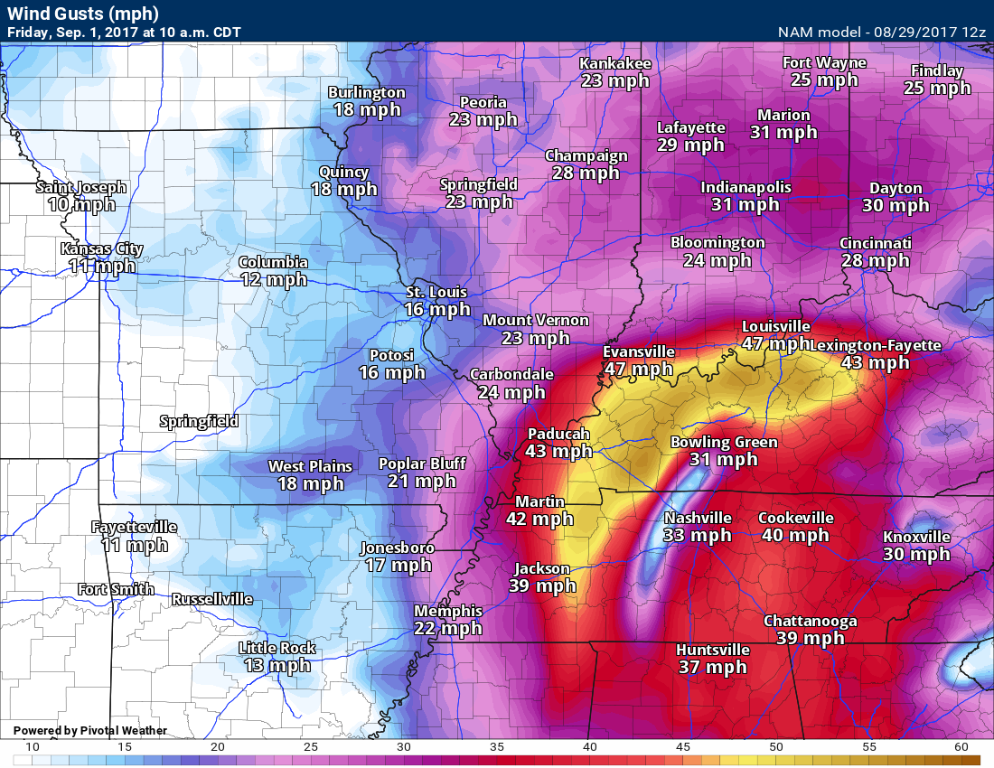
The NAM model shows strong winds on Friday. This is highly dependent on the track.
Someone along the track of this system could experience winds greater than 40 mph.
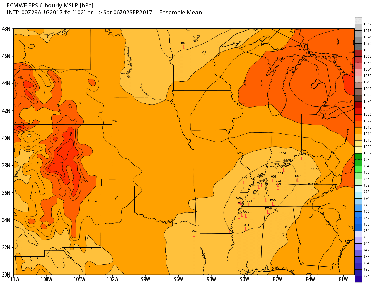
The GFS ensembles want to track the low into western Tennessee. The low represents the center of the remnants of Harvey.
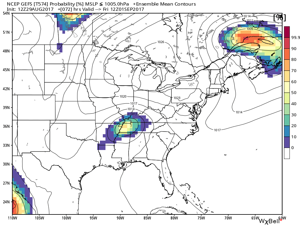
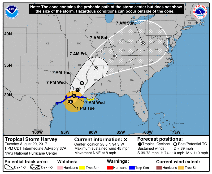
The National Hurricane Center has shifted further south and east with each update. Here was their last update.
The cone of uncertainty does capture portions of our region.
The center point is the most likely path. The surrounding cone is possible path. Keep that in mind.
.
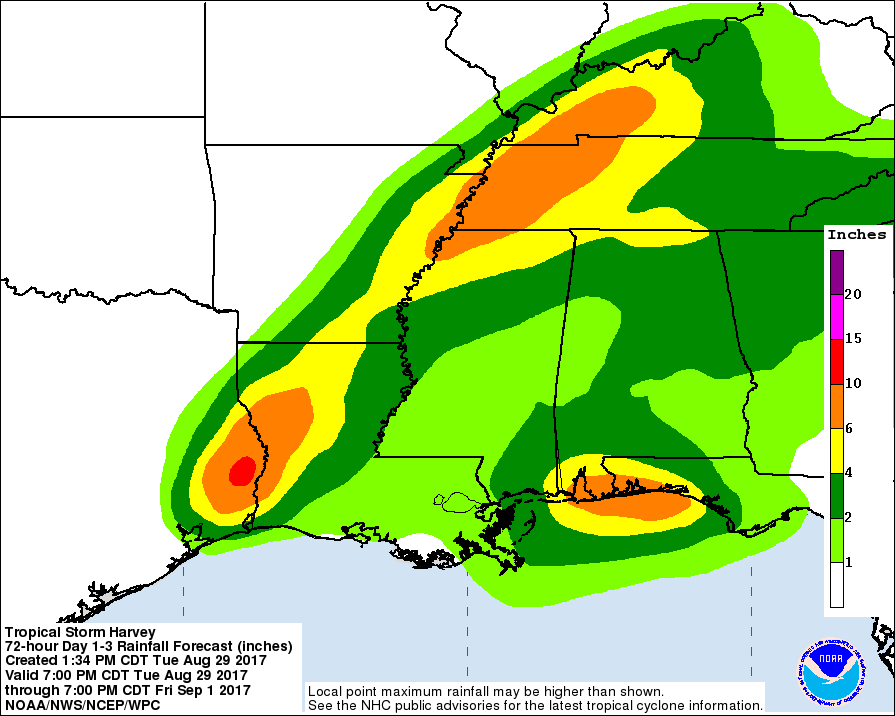
The National Hurricane Center’s forecast for rainfall total potential. This has also been shifted around. It is further south and east than earlier projections.
.
.
Questions remain on the eventual track of this tropical system. Monitor updates. Flash flood watches will likely be issued for portions of Arkansas and Tennessee over the coming days. How far north and west, however, remains a question mark.
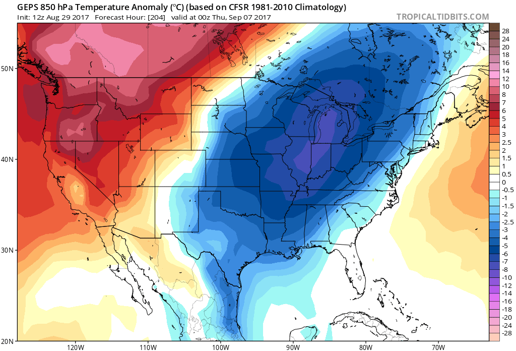
Cool down in early September?
On another note. A big shot of cool air is forecast to enter our region the first part of September. A deep trough digs into our region. This would dip the jet stream way south. WELL below normal temperatures are possible.
Lows into the 40’s would be possible IF the charts verify.
Let me show you some anomaly charts.
This is an ensemble forecast for 850 mb temperature anomaly’s. Well below normal.
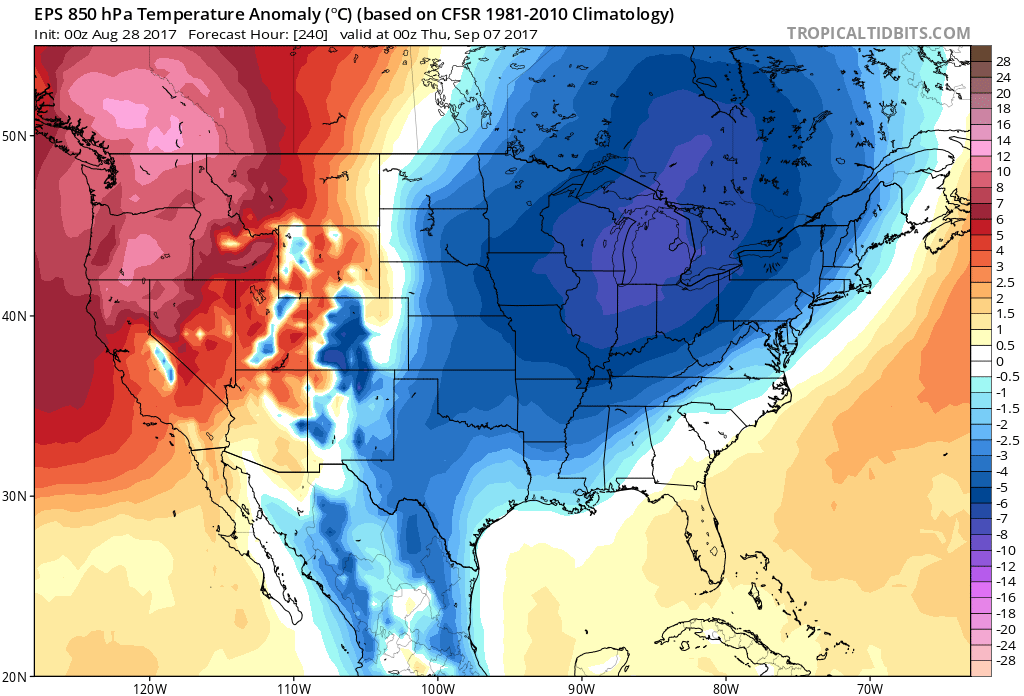
The GFS ensembles agree
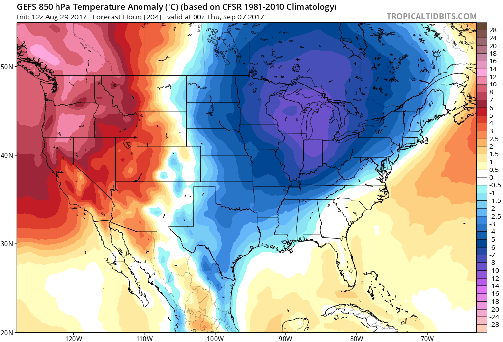
The Canadian also agrees.
August 29, 2017
Good morning, everyone.
If you have not subscribed to all of this data, then please do so. Average monthly costs exceed $2000.00. That is what I pay to bring you this data.
You can subscribe for $3 a month and receive app texts, videos, blog updates, severe weather alerts, daily forecasts, daily texts to all the posts and videos, and more.
A new website and app will be rolled out soon.
Register at www.beaudodsonweather.com
Thank you
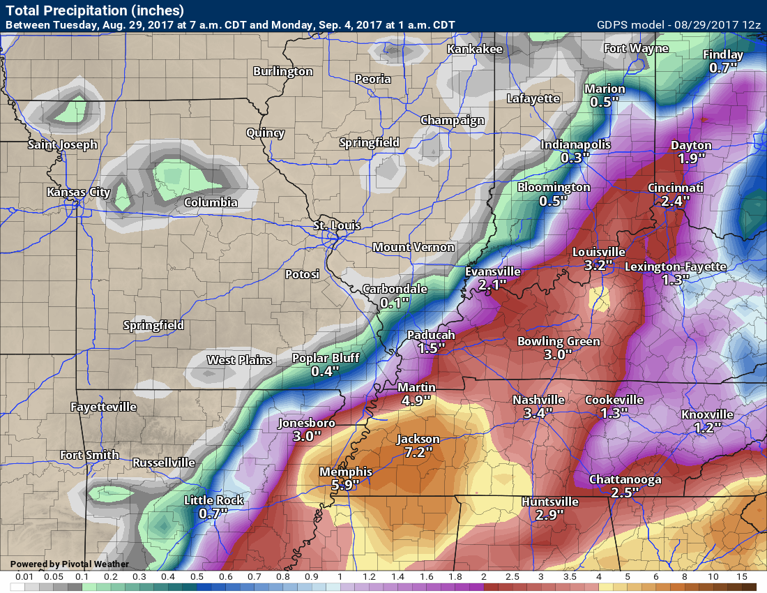
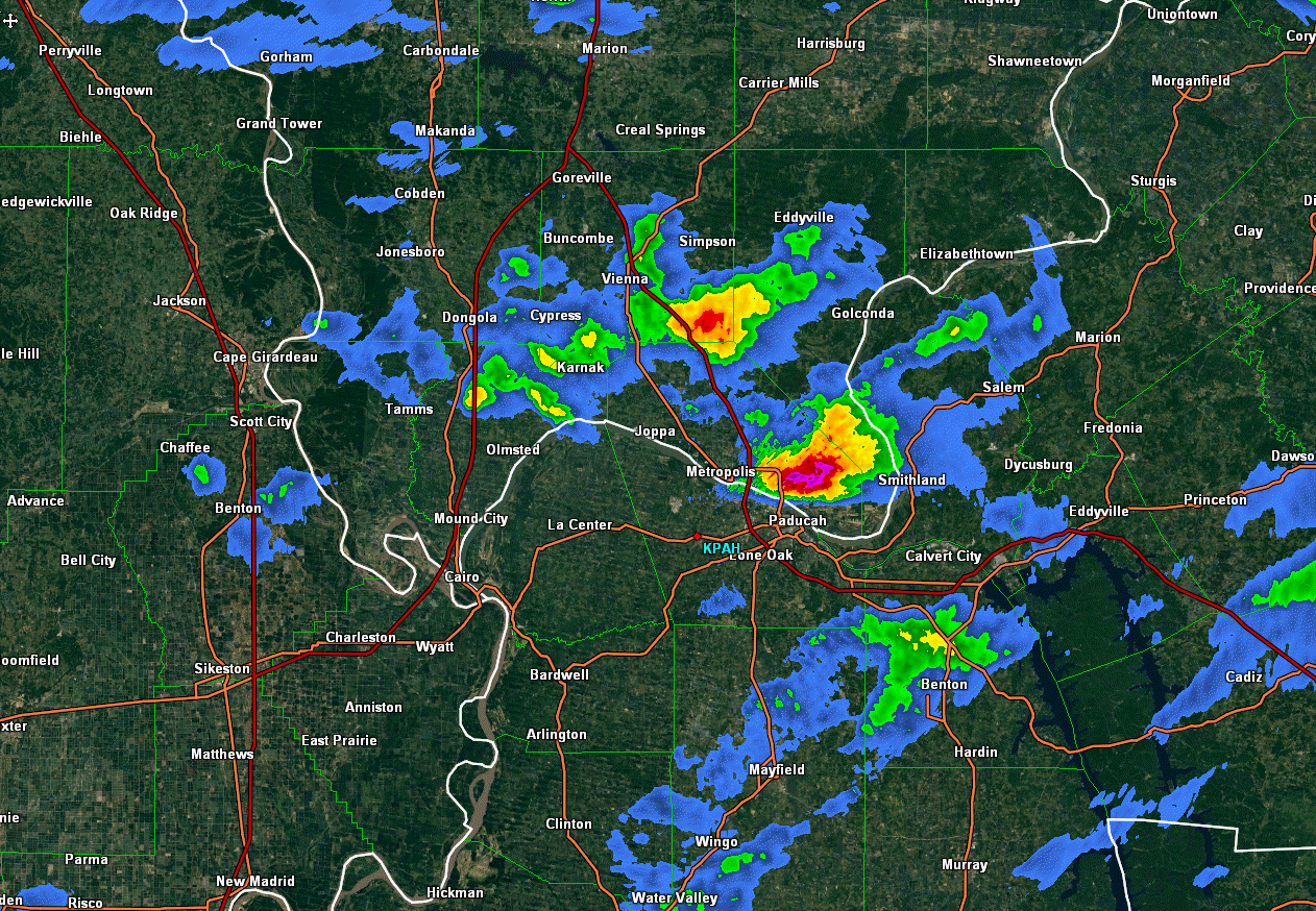
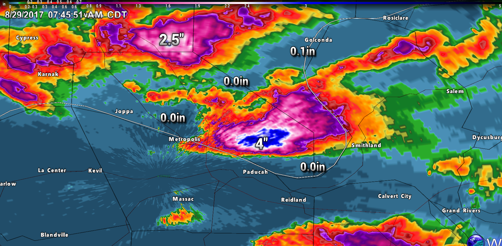
Some heavy rain fell in isolated areas last night. I usually mention slow moving thunderstorms can produce locally higher totals. This is typical for summer. Small areas can receive inches of rain. Areas outside of the slow moving storms often times remain completely dry.
Here are three radar images from Monday night/Tuesday morning. These images are radar rainfall estimates. Quite amazing.
Click images to enlarge.
Radar rainfall estimates. Notice the small areas of bright colors.
Radar estimated rainfall totals

One more image. Notice the areas around the heavy rain with no measurable rainfall. Amazing.
.
Update for Tuesday into the weekend.
The remnants of Harvey will be the main concern in this update. The eventual track of the remnants of Harvey are not certain.
A few things to remember
- I see a broad range of forecasts being placed on the internet. A range of very little rain to over ten inches of rain. It is a bit early to tell everyone how much rain will fall with whatever is left of the remnants of Harvey.
- Confidence on the eventual outcome of this forecast is low.
- Scattered thunderstorm can occur well before the remnants of Harvey arrive. These storms will have plenty of moisture to tap into. Locally heavy rain can occur with any storms that develop over the coming days.
- Strong winds are possible along the track of the remnants of Harvey. Gusts over 40 mph possible. Monitor updates.
- The track of the remnants of Harvey is not a slam dunk forecast. Trends are further south and east.
- I would be leary of rainfall forecasts this far out. Forecasters may not have a handle on this until Wednesday/Wednesday night.
- The bulk of the rain would probably arrive Thursday night into Friday night/Saturday morning. The heaviest totals may end up over Kentucky and Tennessee.
The problem is where the center of the system passes.
The general idea, for the coming days, is that Harvey will slowly move northeast into Louisiana and Arkansas. The system will produce a path of heavy rain and possibly some tornadoes. Gusty winds, as well.
The big questions, at least for our local area, is whether the remnants of Harvey makes a hard right turn before entering the Missouri Bootheel and western Kentucky. Guidance is not in agreement on this subject. The National Hurricane Center has shifted its path a bit to the south and east. This isn’t surprising, based on ensemble forecasting.
The trends over the past two days is to take this system further and further south and east.
Let me show you a few models.
Here is the EC guidance ensembles. The EC shows a further south and east track. It does not bring the area of low pressure (remnants of Harvey) into Missouri or Illinois. It tracks the low into Tennessee and Kentucky. The track is important because the heaviest rain will likely fall near the center.
Click to enlarge
Notice how far south and east the mid-point (black line) for the track is via the EC model guidance. That would spare portions of our region from the bigger rain totals.
One models opinion. These are EC guidance ensemble tracks. They are clustered near the black line.

It is HIGHLY questionable where Harvey makes a right turn and moves off to the east/northeast.
A lot of forecasters are banking on the area of low pressure moving into our region. I don’t believe this is a given and caution is urged when making assumptions based on some models.
Ensemble forecasting and mega-cluster forecasting would lean more towards this system shifting east somewhere in Kentucky and Tennessee. I don’t think the models are finished with their shifting.
This means a lower than normal confidence as to what the sensible impacts of the system will have on our local area. If the low shifts further east, then portions of our region may receive almost no rainfall.
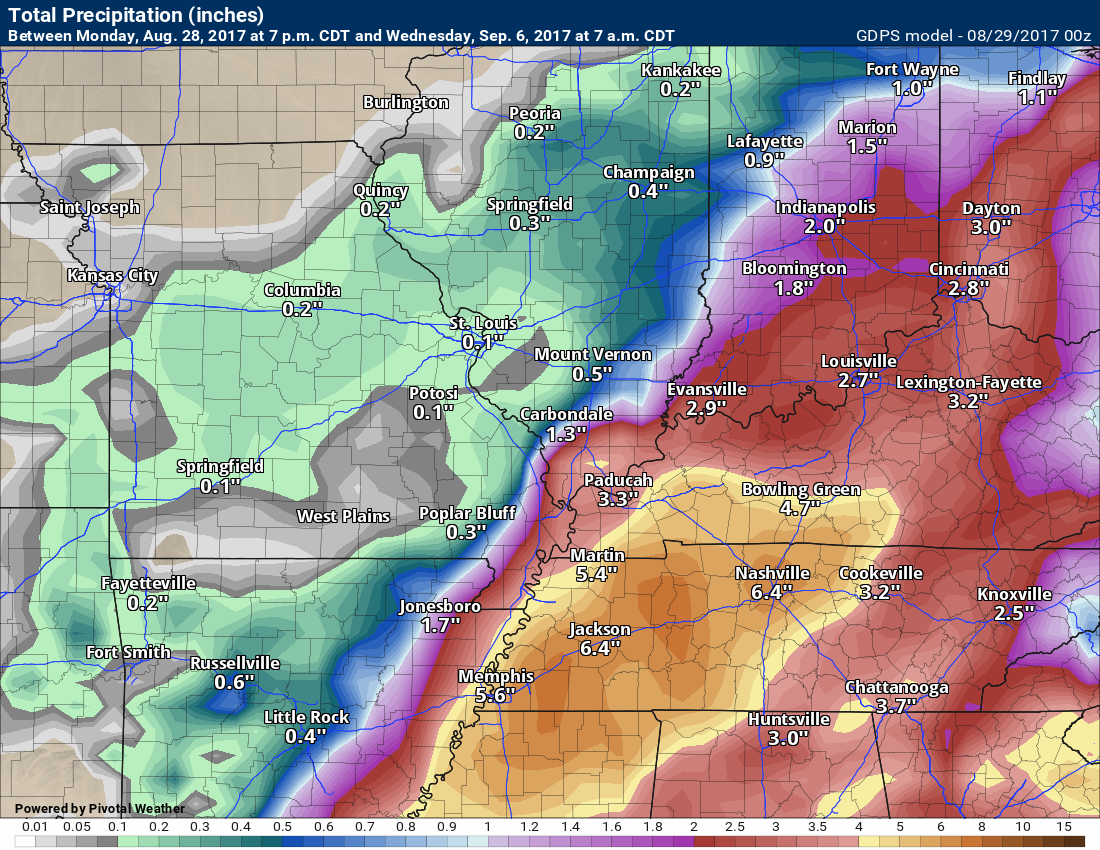
Highest rainfall totals along the track will likely exceed four inches.
Flash flood watches may need to be issues for northeast Arkansas and western Tennessee. We will have to monitor the Missouri Bootheel, southern Illinois, and western Kentucky.
Let’s look at some ensemble forecasts. Ensembles are the same model ran over and over again with slightly different starting parameters. The more ensembles that agree equals a higher confidence in the forecast.
These first graphics are from the SPC SREF ensembles.
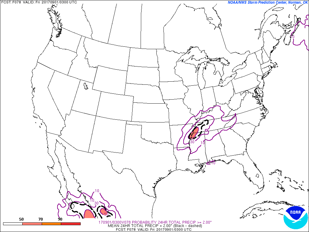
This graphic is showing you the probability of exceeding three inches of rain in 24 hours. Notice how the core of the SREF is over Tennessee.
Click image to enlarge
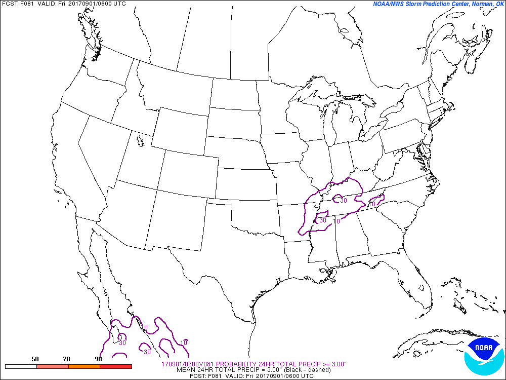
This next graphic is the probability of two inches of rain in 24 hours.
Again, the heaviest totals are skewed towards Tennessee.
This SREF ensemble model graphic shows you where the center of the low might track. Notice how it is skewed to our south and east.
Let’s look at some more guidance
These are EC ensembles. Ensembles are the same model run over and over again. They slightly tweak the beginning numbers. The more that agree, the higher the confidence in the eventual outcome.
These colors represent rainfall totals. The red would be the heaviest totals. Notice how the reds are skewed towards the south and east.
Click to enlarge


The vast majority of EC ensembles track the heaviest rain over Tennessee and Kentucky. The Missouri Bootheel, as well.
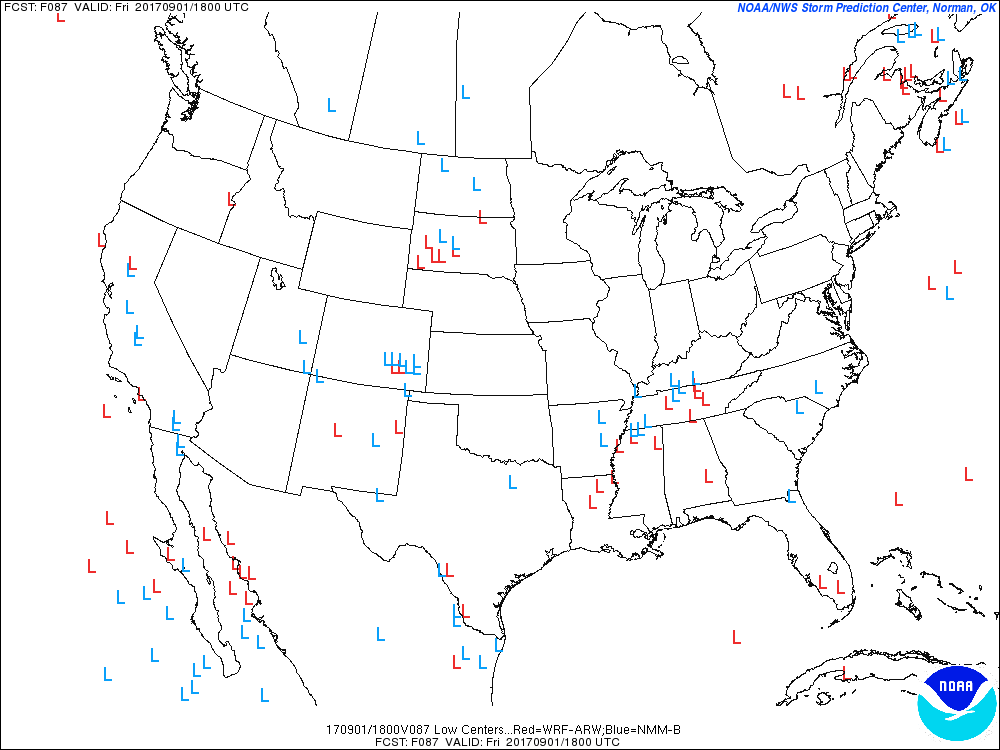
Here are some ensemble member center tracks. The little L’s are the center of the storm. There are so many L’s because these are multiple model runs. Each L represents one model run. If they cluster in one area then confidence rises as to the eventual outcome.
The EC guidance clusters around western Tennessee into parts of Kentucky. How far south and east will be key to our local forecast.
If it tracks over western Kentucky and western Tennessee, then heavy rain totals are likely over a good chunk of our local area.
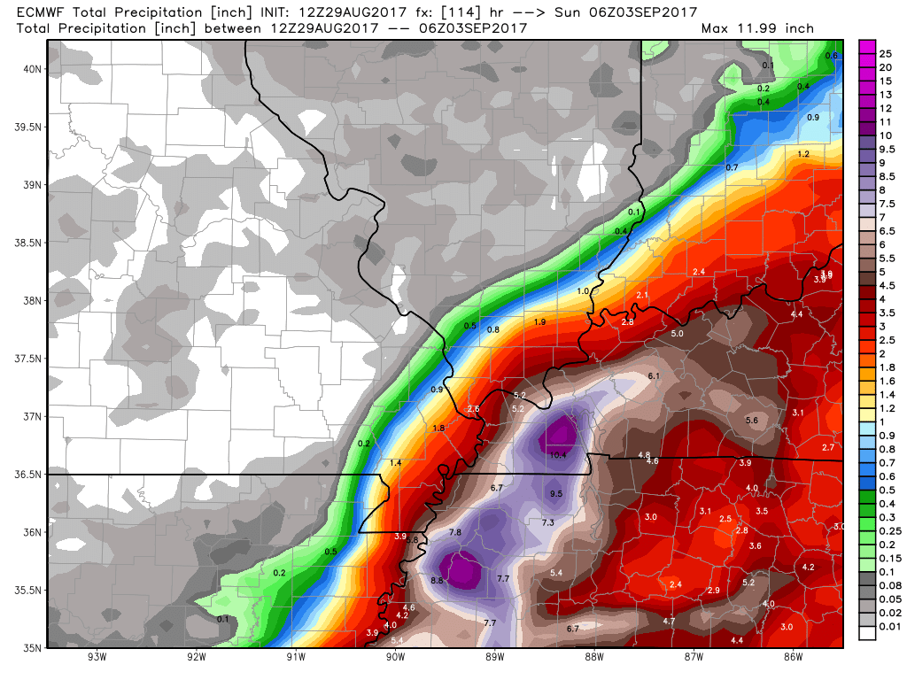
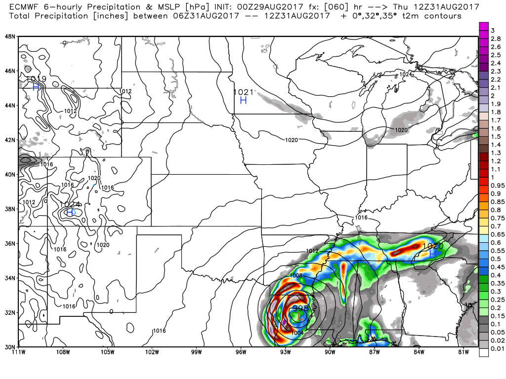
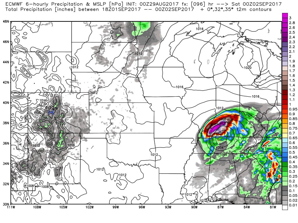
Let’s look at the main run of the EC guidance. This is the model that most forecasters will look at. It is called the operational.
This particular run brings the remnants of Harvey into our local area. Heaviest rain would fall over portions of extreme southern Illinois, portions of southeast Missouri, Kentucky, and Tennessee.
This first graphic is for Thursday at 7 am. You can see the rain just to our south. Creeping into the Missouri Bootheel and western Tennessee.
The colors represent six hour rainfall totals. That would mean 1 am through 7 am Thursday.
The black lines are isobars. Equal lines of pressure. The center of the low is in Louisiana on this first image.
Click image to enlarge
This next graphic shows you the six hour rainfall totals from 1 am Friday morning through 7 am Friday.

This next graphic shows you the six hour rainfall totals from 1 pm Friday through 7 pm Friday
This next graphic shows you the six hour rainfall totals from 7 pm Friday through 1 am Saturday

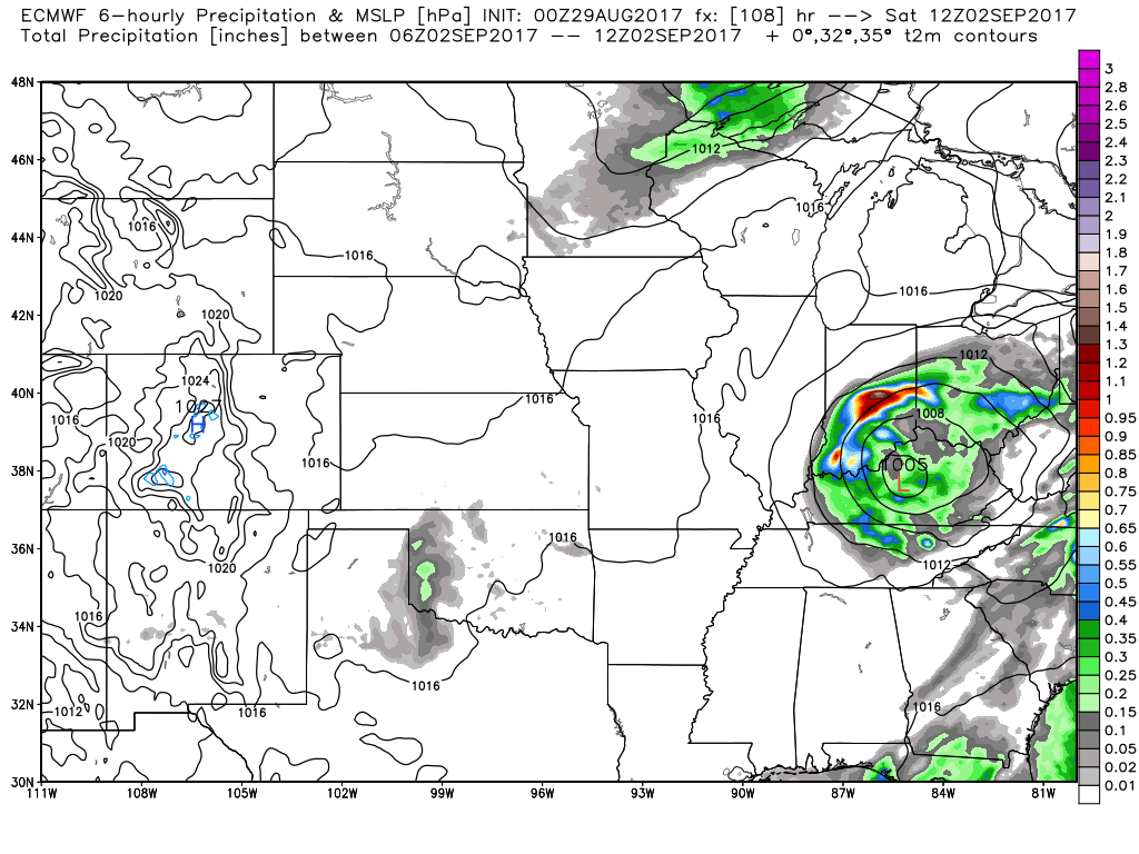
This last image is for 1 am on Saturday through 7 am on Saturday
The EC moves Harvey out of our area on Saturday morning/afternoon.
One model. One opinion.
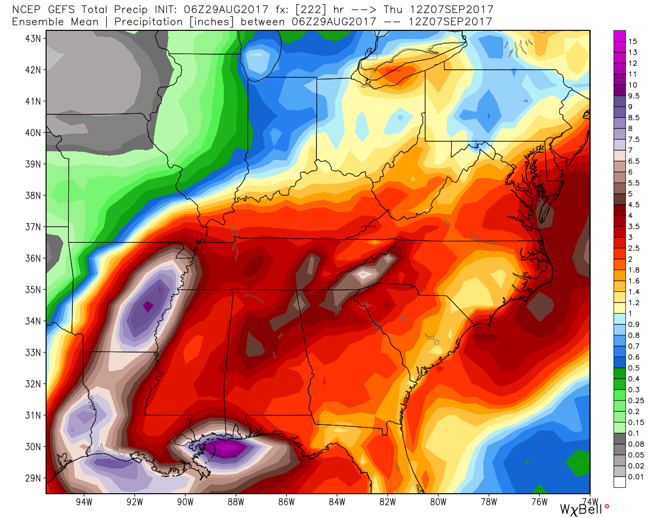
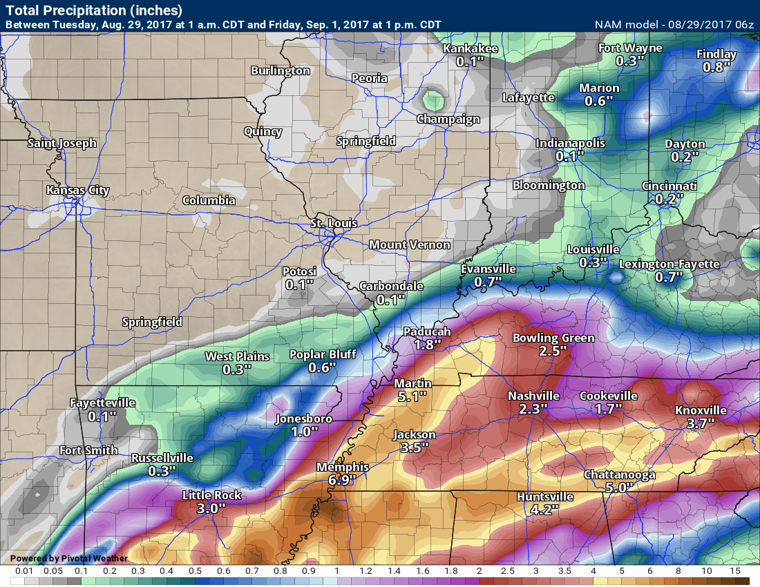
The GFS mean is a bit further north and west of EC guidance
These are rainfall totals based on multiple runs of the GFS model guidance. Notice the large totals in Arkansas. The GFS slows the system in Arkansas and almost stalls it for a period of time. That causes extreme rainfall totals along its path.
Let me show you the Canadian model guidance. It also takes the system more to the south and east. The Canadian is actually further south and east than the EC guidance.
The red L is the center of the remnants of Harvey.
Here are the rainfall totals from the Canadian model guidance.
Needless to say, confidence is not all that great as to the eventual track of Harvey. A great number of guidance packages takes the low further south and east of our area vs straight over our area.
It may be another 24 hours before a better handle on the forecast is achieved. Monitor updates.
The forecast will include showers and thunderstorms beginning as early as Wednesday night over the Missouri Bootheel and western Tennessee. Rain chances would then spread north and east on Thursday into Friday night.
The heaviest rain may arrive on Friday/Friday night.
The NAM rainfall totals are skewed south and east vs north and west. In other words, the NAM seems to agree that the remnants of Harvey would track somewhere into Kentucky and Tennessee.
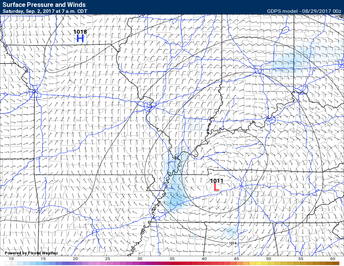
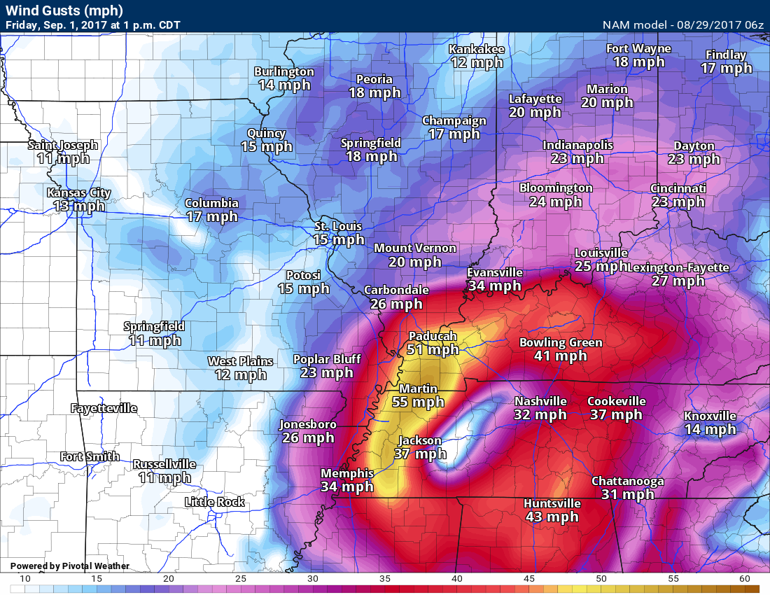
The NAM also shows strong and gusty winds as the center passes to our south and east. Here is the wind gust map for Friday at 1 pm. Notice there are some gusts near 50 mph. Low confidence on the wind forecast, but it is worth monitoring.
I would not bank on these high winds being exactly where the NAM is showing.
We need to see where the low tracks. Where the low tracks is KEY to where higher winds might occur.
I show you this graphic so you will be aware that gusty winds are possible along the path of the remnants of Harvey. Keep that in mind.
Monitor updates moving forward.