


Videos can be viewed at this link. Long Range Video Update
If you believe you missed a video then you can also click the LIVE FEED link on the Weather Talk website. That page holds links for several days.
I can text you the videos, as well. Make sure you have text option FOUR turned on. That would be the Weather Extra text option. Sign up for the text messages at www.beaudodsonweather.com
.

.
This forecast update covers southern Illinois, southeast Missouri, western Kentucky. and northwest Tennessee.
.
The following link is for Weather Text subscribers. This is the page where short and long range video outlooks have been posted. The videos are being produced by a team of meteorologists. Some of the best in the region.
https://weathertalk.com/app/beaucast
..
The September outlook has been posted for subscribers.
Click here to view that outlook
August 24, 2017
Thursday Night Forecast Details:
Forecast: Evening cirrus clouds. Becoming partly cloudy and then clear. Patchy fog. Cool.
Temperatures: MO ~ 52 to 56 IL ~ 52 to 56 KY ~ 56 to 62 TN ~ 56 o 62
Winds: Light from the north and northeast
What impacts are anticipated from the weather? Patchy fog could lower visibility in some areas.
My confidence in the forecast verifying: High. This forecast should verify.
Is severe weather expected? No
The NWS defines severe weather as 58 mph winds or great, 1″ hail or larger, and/or tornadoes
What is the chance of precipitation? MO ~ 0% IL ~ 0% KY ~ 0% TN ~ 0%
Coverage of precipitation: None
Should I cancel my outdoor plans? No
.
August 25, 2017
Friday Forecast Details
Forecast: Mostly sunny. A few passing clouds as a weak system passes through the area. High cirrus clouds again possible.
Temperatures: MO ~ 78 to 82 IL ~ 78 to 82 KY ~ 78 to 82 TN ~ 78 to 82
Winds: Northeast at 4 to 8 mph with gusts to 14 mph
What impacts are anticipated from the weather? None
My confidence in the forecast verifying: High. This forecast should verify.
Is severe weather expected? No
The NWS defines severe weather as 58 mph winds or great, 1″ hail or larger, and/or tornadoes
What is the chance of precipitation? MO ~ 0% IL ~ 0% KY ~ 0% TN ~ 0%
Coverage of precipitation: None
Should I cancel my outdoor plans? No
.
Friday Night Forecast Details:
Forecast: Some evening clouds, then mostly clear.
Temperatures: MO ~ 56 to 62 IL ~ 56 to 62 KY ~ 56 to 62 TN ~ 56 to 62
Winds: Light northeast winds at 5 mph
What impacts are anticipated from the weather? Patchy fog could lower visibility in some areas.
My confidence in the forecast verifying: High. This forecast should verify.
Is severe weather expected? No
The NWS defines severe weather as 58 mph winds or great, 1″ hail or larger, and/or tornadoes
What is the chance of precipitation? MO ~ 0% IL ~ 0% KY ~ 0% TN ~ 0%
Coverage of precipitation: None
Should I cancel my outdoor plans? No
.
August 26, 2017
Saturday Forecast Details
Forecast: Mostly sunny. Pleasant.
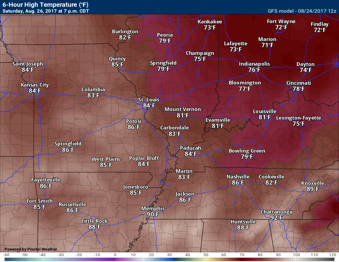
Temperatures: MO ~ 78 to 84 IL ~ 78 to 84 KY ~78 to 84 TN ~ 78 to 84
Winds: Northeast and east at 4 to 8 mph with gusts to 12 mph
What impacts are anticipated from the weather? None
My confidence in the forecast verifying: High. This forecast should verify.
Is severe weather expected? No
The NWS defines severe weather as 58 mph winds or great, 1″ hail or larger, and/or tornadoes
What is the chance of precipitation? MO ~ 0% IL ~ 0% KY ~ 0% TN ~ 0%
Coverage of precipitation: None
Should I cancel my outdoor plans? No
.
Saturday night Forecast Details:
Forecast: Mostly clear.
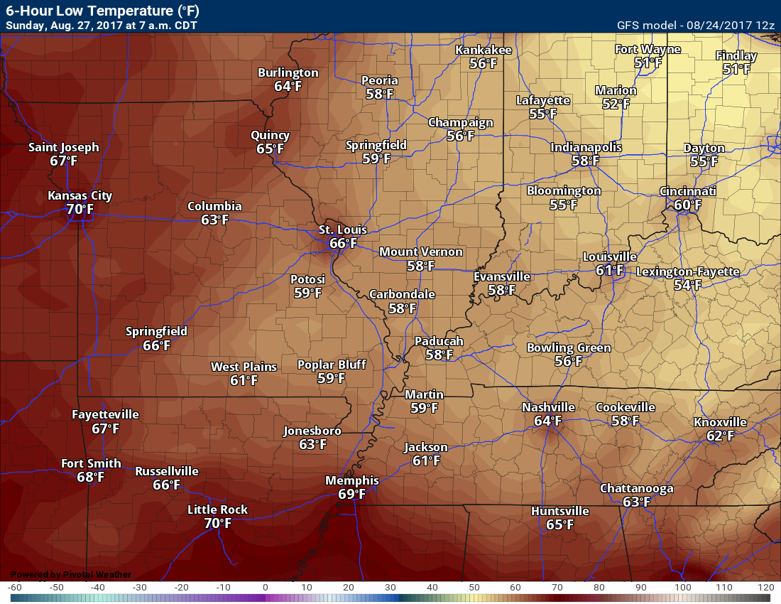
Temperatures: MO ~ 56 to 64 IL ~ 56 to 64 KY ~ 56 to 64 TN ~ 56 to 64
Winds: Northeast and east at 5 mph
What impacts are anticipated from the weather? Patchy fog could lower visibility in some areas.
My confidence in the forecast verifying: High. This forecast should verify.
Is severe weather expected? No
The NWS defines severe weather as 58 mph winds or great, 1″ hail or larger, and/or tornadoes
What is the chance of precipitation? MO ~ 0% IL ~ 0% KY ~ 0% TN ~ 0%
Coverage of precipitation: None
Should I cancel my outdoor plans? No
.
August 27, 2017
Sunday Forecast Details
Forecast: Partly to mostly sunny. Mild. Some increase in clouds late in the day.
Temperatures: MO ~ 84 to 86 IL ~ 84 to 86 KY ~ 84 to 86 TN ~ 84 to 86
Winds: East and southeast winds at 5 to 10 mph
What impacts are anticipated from the weather? None
My confidence in the forecast verifying: High
Is severe weather expected? No
The NWS defines severe weather as 58 mph winds or great, 1″ hail or larger, and/or tornadoes
What is the chance of precipitation? MO ~ 10% IL ~ 10% KY ~ 0% TN ~ 0%
Coverage of precipitation: None
Should I cancel my outdoor plans? No
.
Sunday Night Forecast Details:
Forecast: Increasing clouds. A chance for a few showers.
Temperatures: MO ~ 56 to 62 IL ~ 56 to 62 KY ~ 56 to 62 TN ~ 56 to 62
Winds: Light and variable
What impacts are anticipated from the weather? Wet roadways.
My confidence in the forecast verifying: Medium. Adjustments are possible.
Is severe weather expected? No
The NWS defines severe weather as 58 mph winds or great, 1″ hail or larger, and/or tornadoes
What is the chance of precipitation? MO ~ 40% IL ~ 40% KY ~ 30% TN ~ 30%
Coverage of precipitation: Scattered late at night
Should I cancel my outdoor plans? No
.
August 28, 2017
Monday Forecast Details
Forecast: Mostly cloudy. A chance for a shower or thunderstorm.
Temperatures: MO ~ 76 to 82 IL ~ 76 to 82 KY ~78 to 84 TN ~78 to 84
Winds: Southeast at 5 to 10 mph
What impacts are anticipated from the weather? Wet roadways. Isolated lightning.
My confidence in the forecast verifying: Medium. Adjustments are possible
Is severe weather expected? No
The NWS defines severe weather as 58 mph winds or great, 1″ hail or larger, and/or tornadoes
What is the chance of precipitation? MO ~ 40% IL ~ 40% KY ~ 40% TN ~ 40%
Coverage of precipitation: Scattered
Should I cancel my outdoor plans? Monitor radars
.
Monday Night Forecast Details:
Forecast: Cloudy. Scattered showers and thunderstorms possible.
Temperatures: MO ~ 62 to 66 IL ~ 62 to 66 KY ~ 62 to 66 TN ~ 62 to 66
Winds: Variable winds at 4 to 8 mph
What impacts are anticipated from the weather? Wet roadways. Perhaps lightning
My confidence in the forecast verifying: Low. Significant adjustments are possible.
Is severe weather expected? No
The NWS defines severe weather as 58 mph winds or great, 1″ hail or larger, and/or tornadoes
What is the chance of precipitation? MO ~ 40% IL ~ 40% KY ~ 40% TN ~ 40%
Coverage of precipitation: Scattered
Should I cancel my outdoor plans? Monitor radars
.
August 29, 2017
Tuesday Forecast Details
Forecast: Partly cloudy. Scattered showers possible. Rumble of thunder.
Temperatures: MO ~ 76 to 82 IL ~ 76 to 82 KY ~78 to 84 TN ~78 to 84
Winds: Southeast at 5 to 10 mph
What impacts are anticipated from the weather? Wet roadways. Isolated lightning.
My confidence in the forecast verifying: Low. Significant adjustments are possible.
Is severe weather expected? No
The NWS defines severe weather as 58 mph winds or great, 1″ hail or larger, and/or tornadoes
What is the chance of precipitation? MO ~ 20% IL ~ 20% KY ~ 20% TN ~ 30%
Coverage of precipitation: Scattered
Should I cancel my outdoor plans? Monitor radars
.
Tuesday Night Forecast Details:
Forecast: Partly cloudy. Isolated shower possible.
Temperatures: MO ~ 58 to 64 IL ~ 58 to 64 KY ~ 58 to 64 TN ~ 58 to 64
Winds: Variable at 5 mph
What impacts are anticipated from the weather? Wet roadways. Isolated lightning.
My confidence in the forecast verifying: Low. Significant adjustments are possible.
Is severe weather expected? No
The NWS defines severe weather as 58 mph winds or great, 1″ hail or larger, and/or tornadoes
What is the chance of precipitation? MO ~ 10% IL ~ 10% KY ~ 10% TN ~ 10%
Coverage of precipitation: Isolated.
Should I cancel my outdoor plans? Monitor updates
.
August 30, 2017
Wednesday Forecast Details
Forecast: Partly to mostly sunny.
Temperatures: MO ~ 76 to 82 IL ~ 76 to 82 KY ~78 to 84 TN ~78 to 84
Winds: Variable at 5 to 10 mph
What impacts are anticipated from the weather?
My confidence in the forecast verifying: Low. Significant adjustments are possible.
Is severe weather expected? No
The NWS defines severe weather as 58 mph winds or great, 1″ hail or larger, and/or tornadoes
What is the chance of precipitation? MO ~ 10% IL ~ 10% KY ~ 10% TN ~ 10%
Coverage of precipitation:
Should I cancel my outdoor plans?
.
Wednesday Night Forecast Details:
Forecast: Partly cloudy.
Temperatures: MO ~ 58 to 64 IL ~ 58 to 64 KY ~ 58 to 64 TN ~ 58 to 64
Winds: Variable at 5 mph
What impacts are anticipated from the weather?
My confidence in the forecast verifying: Low. Significant adjustments are possible.
Is severe weather expected?
The NWS defines severe weather as 58 mph winds or great, 1″ hail or larger, and/or tornadoes
What is the chance of precipitation? MO ~ 10% IL ~ 10% KY ~ 10% TN ~ 10%
Coverage of precipitation:
Should I cancel my outdoor plans?
.

Don’t forget to check out the Southern Illinois Weather Observatory web-site for weather maps, tower cams, scanner feeds, radars, and much more! Click here

A severe thunderstorm is defined as a storm that produces quarter size hail or larger, 58 mph winds or greater, and/or a tornado. That is the official National Weather Service definition of a severe thunderstorm
Thursday night through Sunday: Severe weather is not anticipated.
Monday through Wednesday of next week: A few thunderstorms are possible Sunday night into Monday. Tuesday may also have some spotty showers and storms, but confidence on Tuesday is rather low.
I continue to monitor the tropical system moving into Texas. Too early to know if it will impact our region with rain showers.

There are a lot of graphics today.
The weather has been nice over the last 24 hours. Low dew points and nice temperatures. Could not ask for better weather during the Month of August. I am loving it.
The weather will continue to be nice through Sunday. Dew points will increase a bit on Sunday and Monday, but not oppressive. Temperatures will remain below normal through Sunday.
High pressure, located to our east, will be in firm control of our weather. Sinking air is helping to squash most of the clouds. The high will continue to dominate into the weekend.
This has also helped to keep our dew points lower. Remember, dew points are what control how you feel outside (some consider humidity to be the main factor). Dew points are a better way of measuring moisture in the atmosphere.
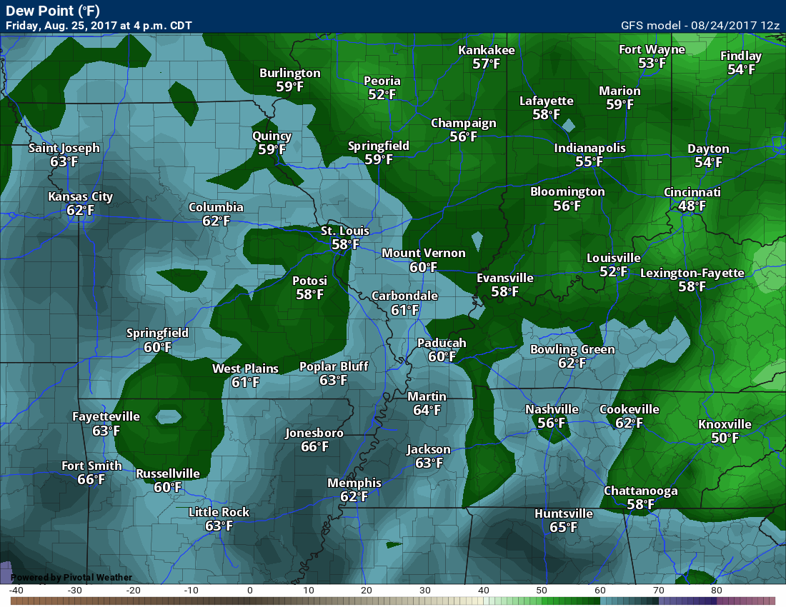
Friday dew points. Dew points in the 50’s are considered nice. Once you start talking about 65 to 70 it becomes humid.
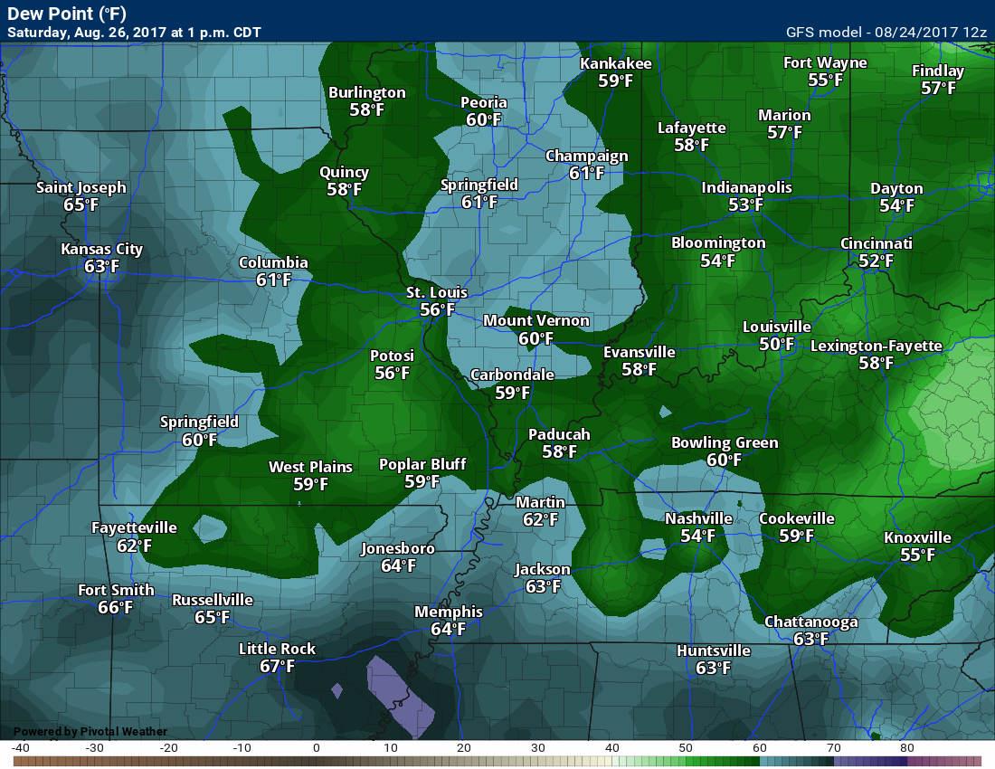
Saturday dew points
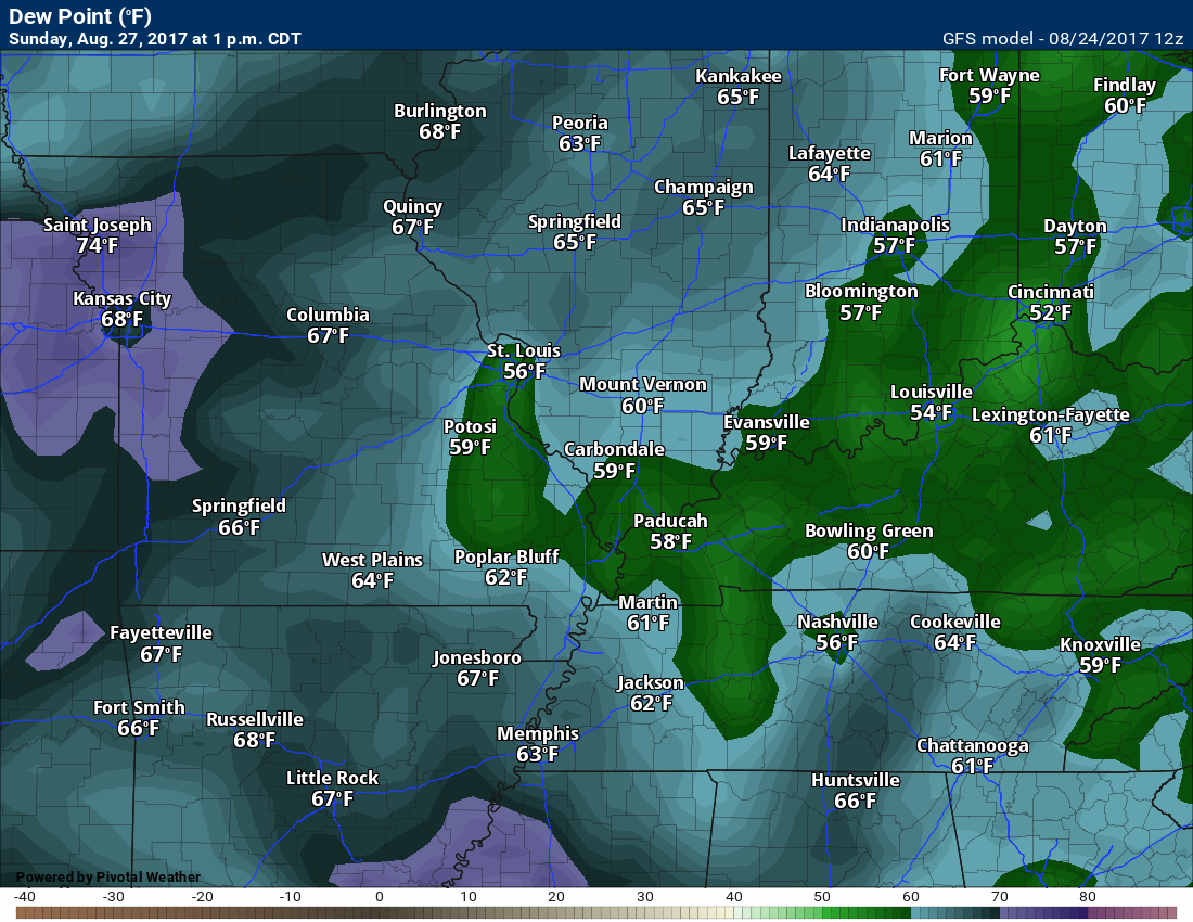
Sunday dew points
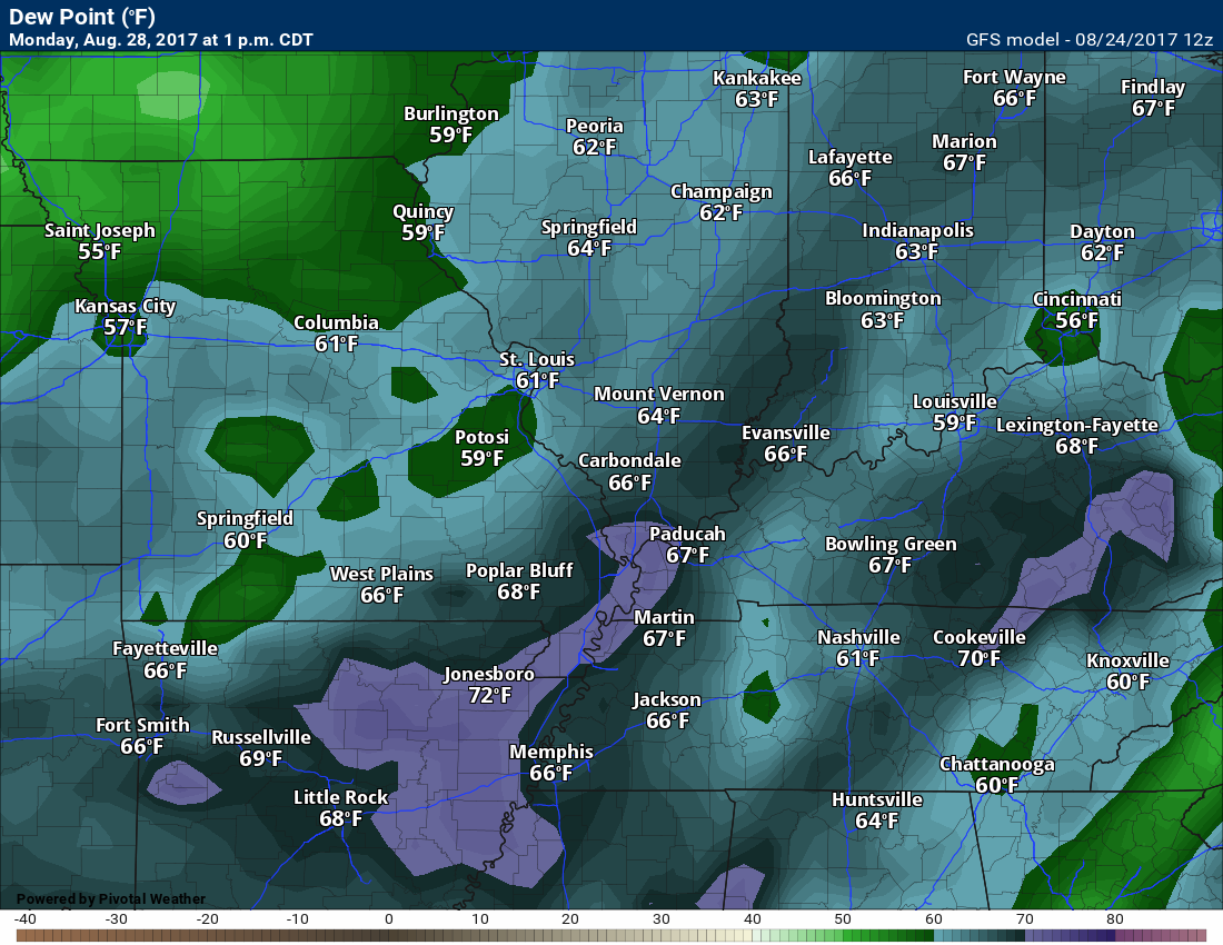
Monday dew points are a bit higher ahead of the shortwave/frontal boundary.
The GFS model is showing mid to upper 80’s on Sunday, but I think it is overdoing it. I will monitor trends. Either way, a slow warming trend is likely over the weekend.
A frontal system/shortwave will push into our region Sunday night and Monday. This front will have some moisture to work with. Expect a band of showers and thunderstorms along the front. This would be moving in from the north. The best chance of rain may hold off until late Sunday night and Monday.
Monday night and Tuesday have rain showers in the forecast, but confidence is lower.
The shortwave responsible for our rain chances should move along at a decent pace. I did note some models lingering rain chances into Tuesday and Wednesday. Other models are dry.
For now, I have smaller rain chances for Tuesday and Wednesday.
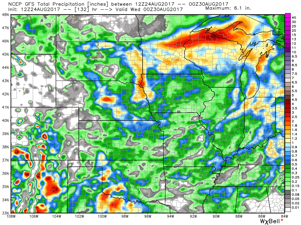
Here is what the GFS model is showing for rainfall totals Sunday night into Tuesday.
Confidence on totals is still rather low.
I continue to monitor Harvey. Model guidance is useless. The slow moving tropical storm will move into Texas over the coming 48 hours. This system will spread heavy rain into eastern Texas. Some locations will pick up ten to twenty inches of rain. Needless to say, this will cause life threatening flash flooding.
The system will then slowly meander around eastern Texas. Some of the guidance picks the system up and moves it east/northeast into Arkansas and Louisiana. A trough to our north could pull the system north and northeast. Confidence on this happening, however, is very low.
If the system were to impact our region, then we would see an increasing chance of rain later next week. The timing of the system is impossible to forecast this far out. We don’t even know if the system will be pulled into our region. Monitor updates.
Most guidance would not bring it into our local region until Thursday, Friday, Saturday, or Sunday. Again, no way of knowing this, yet.
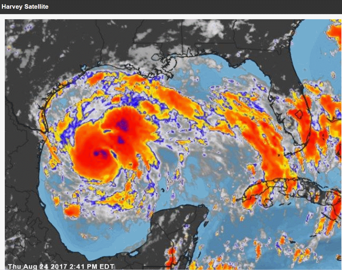
Here is the Thursday afternoon satellite view of Harvey. You can see the swirling bands.
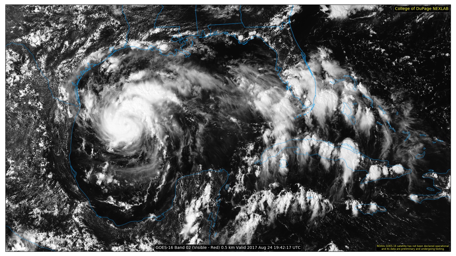
Here is a visible satellite image
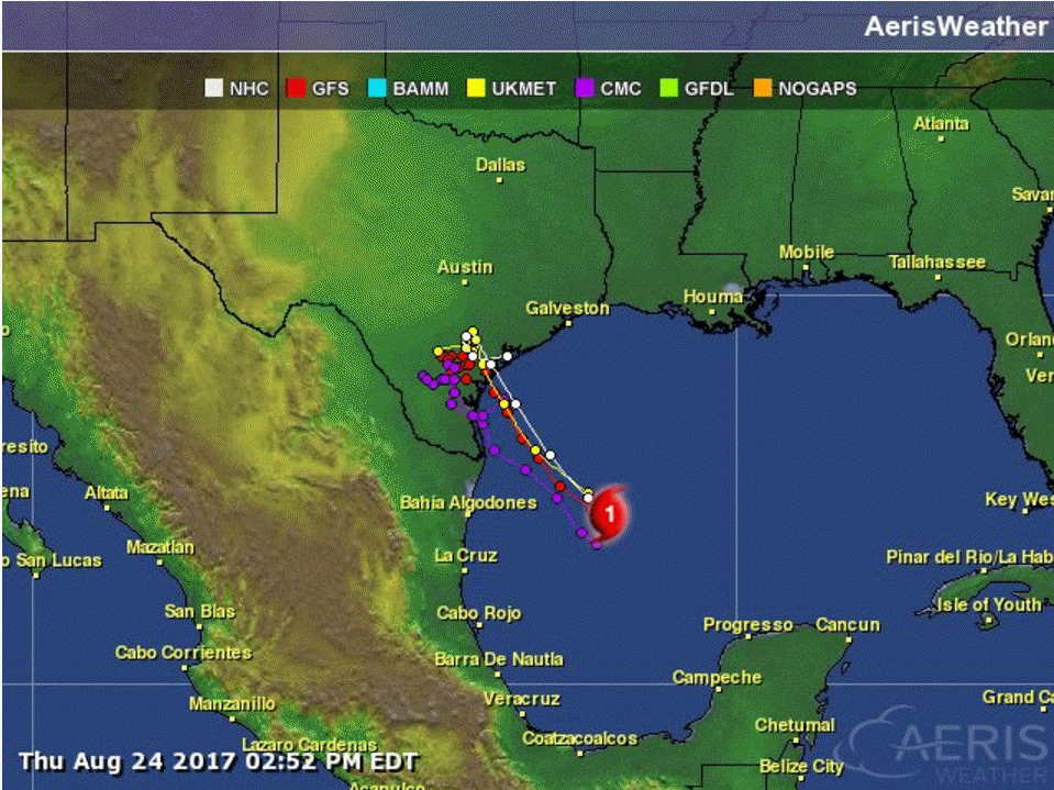
Here are the model tracks. They are clustered fairly close together. This would bring Harvey into the southeast coast of Texas.
The GFS model brings it ashore over the coming days.
The black lines are equal lines of pressure. The middle of those would be the center of the system. You can see it there in extreme southern Texas.
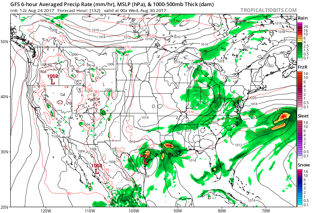
Notice the GFS then shifts it into Louisiana by next week (late according to the GFS)
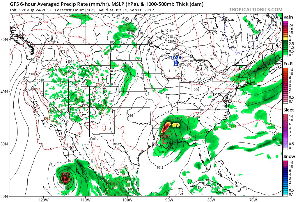
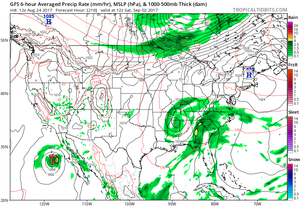
The GFS then pulls it northward around September 2nd. One models opinion.
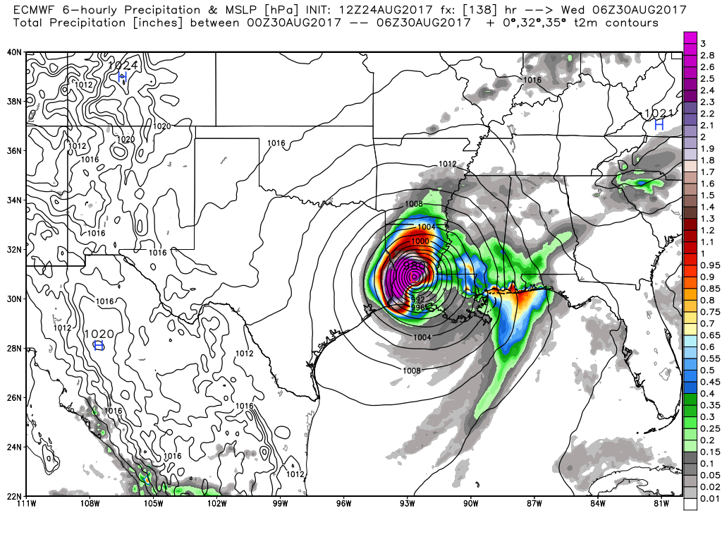
The EC guidance (another model) brings it into the southeast coast of Texas by Saturday and Sunday.
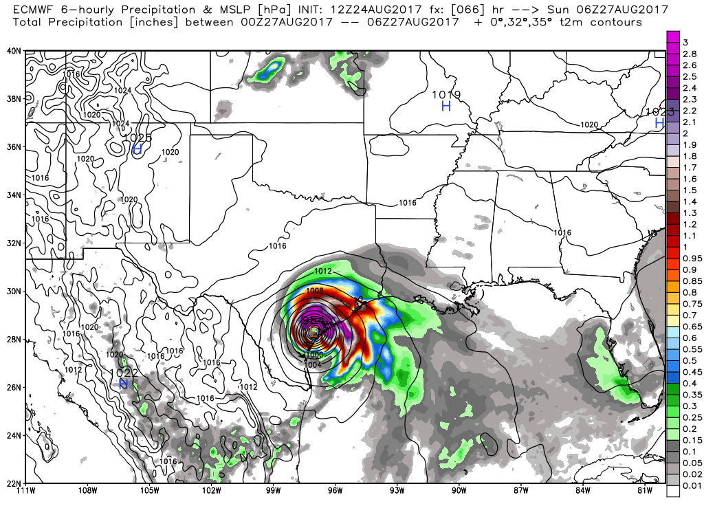
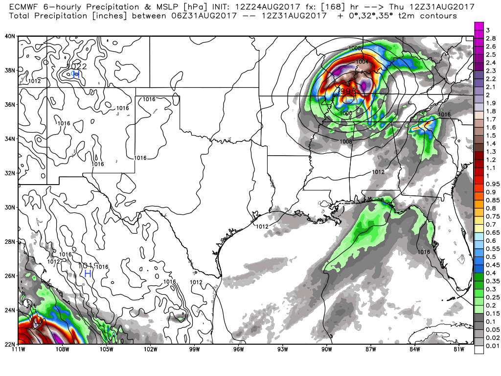
EC then brings it into Louisiana by Wednesday of next week. See the closely packed black lines? Those are isobars. Equal lines of pressure. Tightly packed pressure lines would mean strong and gusty winds. Heavy rain.
The EC then brings it into our region by next Thursday. Heavy rain would be the end result. One models opinion.
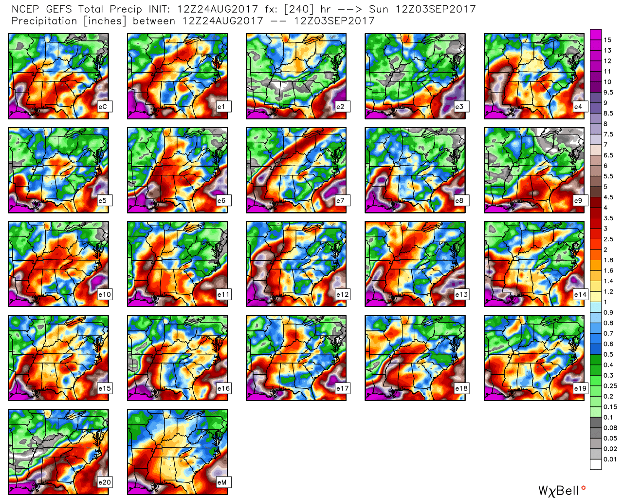
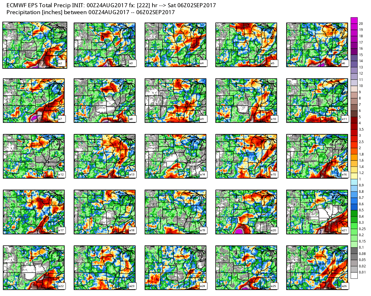
The GFS ensembles. These are the same model slides, but each run is slightly tweaked. The more squares that agree with each other, the more likely the scenario is to happen. Quite a few of them bringing the system into our region. Something worth monitoring.
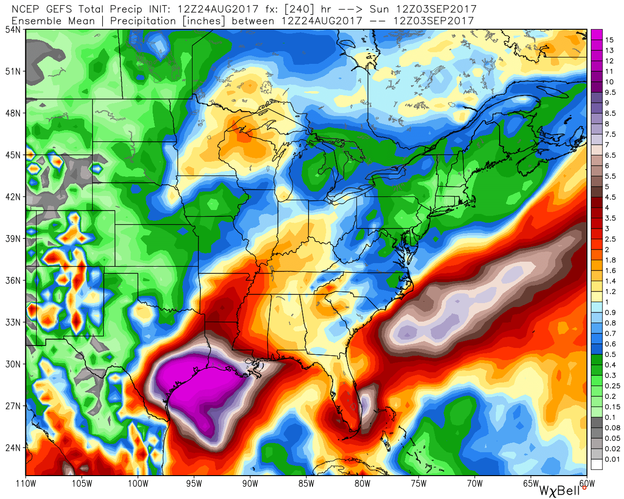
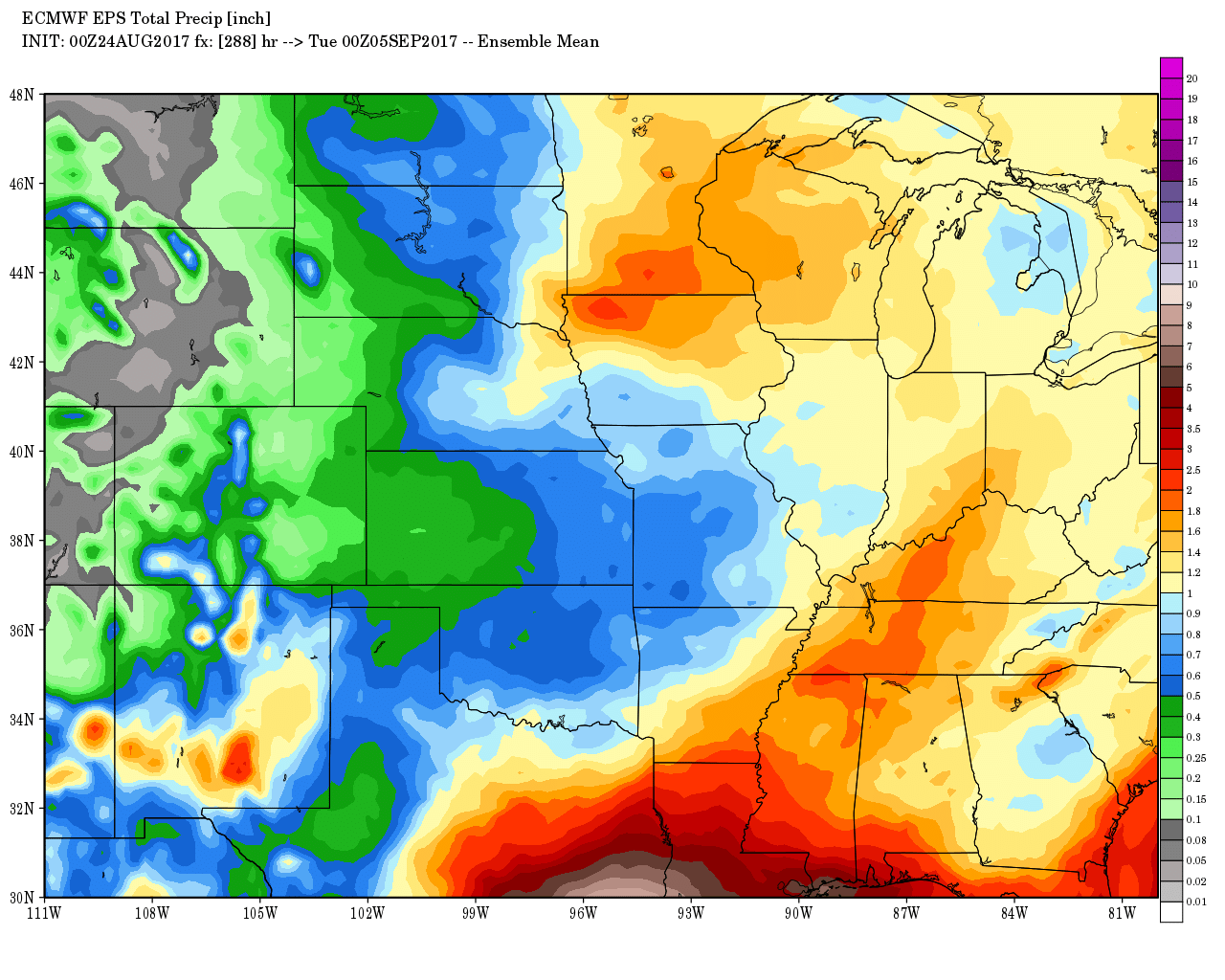
Is the GFS mean. All the ensembles brought together. It does bring the rain into our region.
The EC, on the other hand, keeps the system mostly to our south and southeast.
Here is the EC mean.
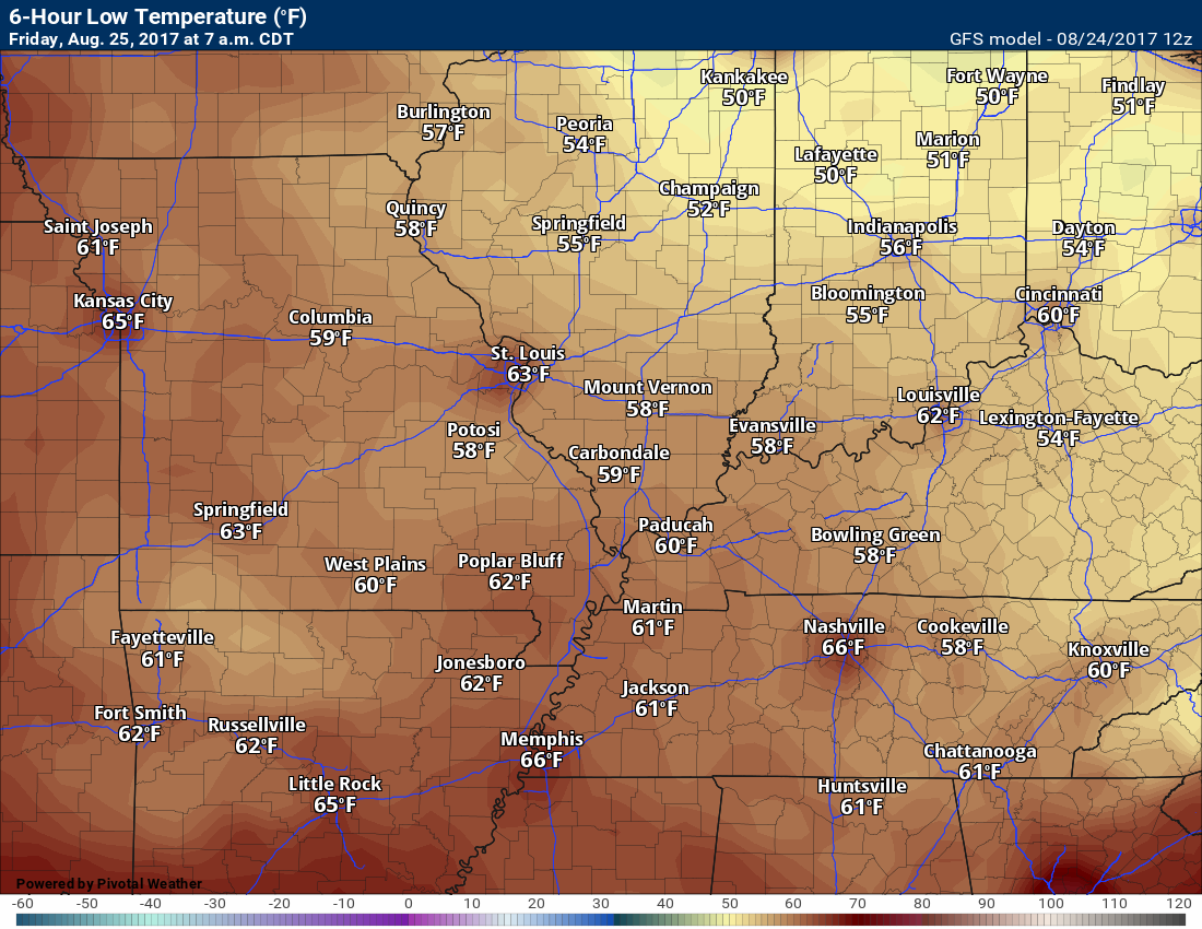
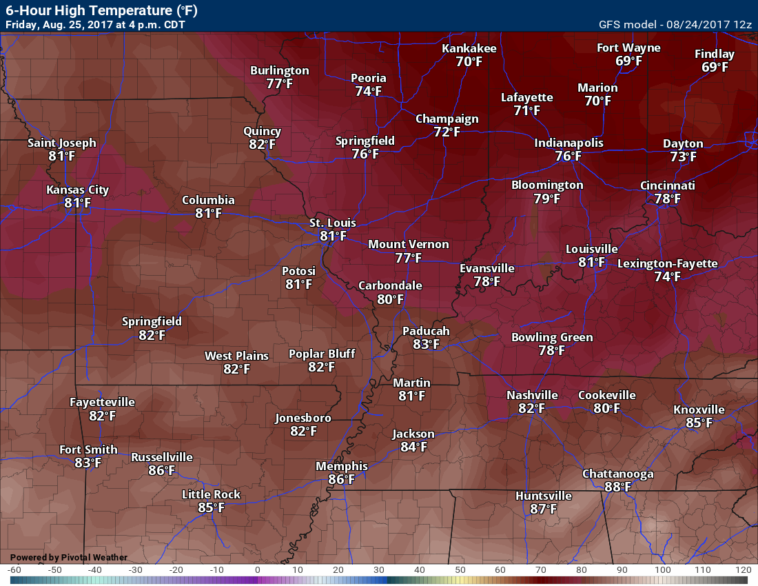
Temperature Forecast
Friday highs
Saturday lows
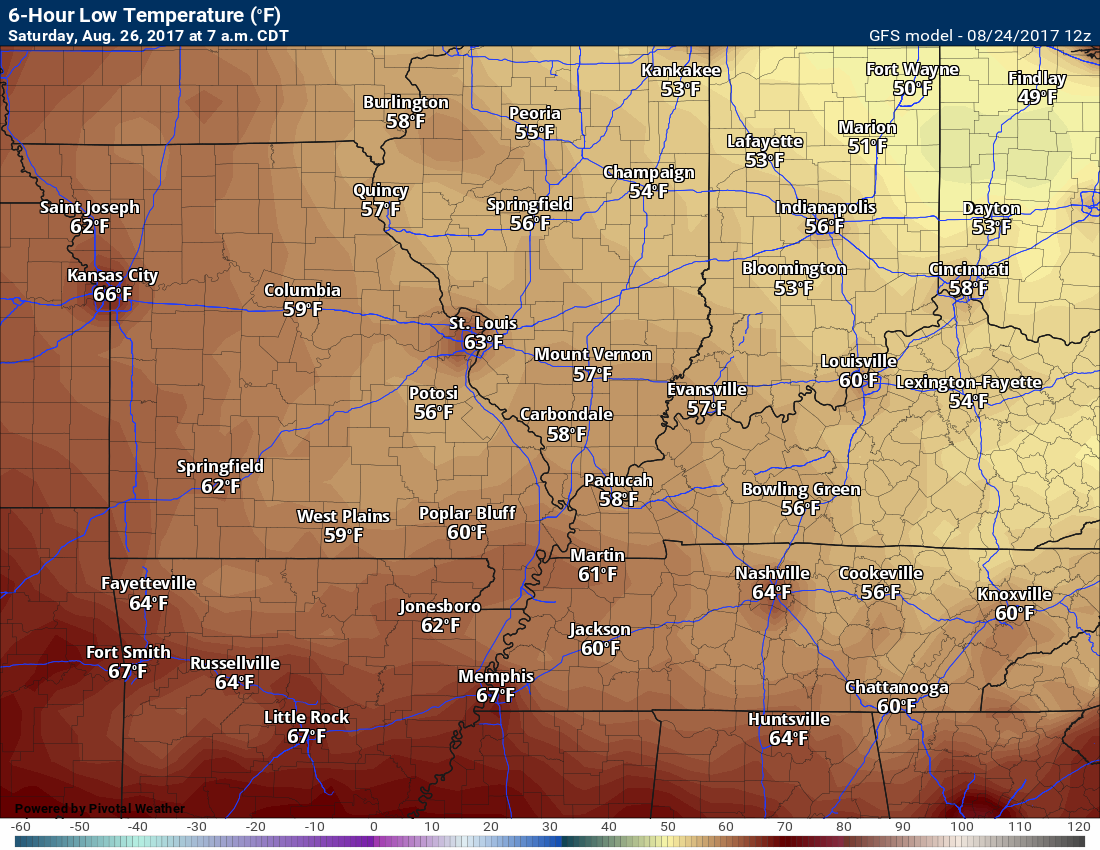
Saturday highs
Sunday lows
Sunday highs
GFS may be a bit too warm. This is what it is showing.
Are you subscribing to the Weather Talk texts and videos?
We now have premiere videos for the short and long range forecasts! Make sure you have text option four turned on (green).
Sign up at www.beaudodsonweather.com
We also have an Apple and Android app (scroll down to bottom of the page for more information)

Were you aware that I have hired some help for long range videos? Short range videos, as well. An amazing team of meteorologists.
Click the link below to read more
http://cms.weathertalk.com/meet-the-team/
Weather Talk subscribers now have some of the best short and long range weather videos produced across the eastern United States.
.

Find me on Twitter
.

We have regional radars and local city radars – if a radar does not update then try another one. Occasional browsers need their cache cleared. You may also try restarting your browser. That usually fixes the problem. Occasionally we do have a radar go down. That is why I have duplicates. Thus, if one fails then try another one.
During the winter you can track snow and ice by clicking the winterize button on the local city view interactive radars.
If you have any problems then please send me an email beaudodson@usawx.com
Interactive Weather Radar Page. Choose the city nearest your location: Click this link—
National interactive radar: Click this link.
Local interactive city radars include St Louis, Mt Vernon, Evansville, Poplar Bluff, Cape Girardeau, Marion, Paducah, Hopkinsville, Memphis, Nashville, Dyersburg, and all of eastern Kentucky. These are interactive radars. Local city radars – click here
The Beau Dodson Weather APP is ready for Apple and Android users. The purpose of this app is for me to deliver your text messages instantly. ATT and Verizon have not always been reliable when it comes to speed. The app allows instant delivery.
Some of you have asked if you can keep receiving the texts on your phone and the app. The answer to that is, yes. The Android app will automatically allow that to happen. On the Apple app, however, you will need to go into your app and click settings. Make sure the green tab is OFF. Off means you will still receive the texts to your phone and the app. If you have any questions, then email me at beaudodson@usawx.com
The app is for text subscribers.
The direct download, for the Apple app, can be viewed here
https://itunes.apple.com/us/app/id1190136514
If you have not signed up for the texting service then you may do so at www.beaudodsonweather.com

The Android app is also ready.
Remember, the app’s are for www.weathertalk.com subscribers. The app allows your to receive the text messages faster than ATT and Verizon.
Here is the download link for the Android version Click Here

——————————————————–
If you have not signed up for the texts messages, then please do. Link www.beaudodsonweather.com
Your support helps with the following:

and


Who do you trust for your weather information and who holds them accountable?
I have studied weather in our region since the late 1970’s. I have 39 years of experience in observing our regions weather patterns. My degree is in Broadcast Meteorology and a Bachelor’s of Science.
My resume includes:
Member of the American Meteorological Society.
NOAA Weather-Ready Nation Ambassador.
Meteorologist for McCracken County Emergency Management. I served from 2005 through 2015.
Meteorologist for McCracken County Rescue. 2015 through current
I own and operate the Southern Illinois Weather Observatory.
I am the chief meteorologist for Weather Talk LLC. I am the owner of Weather Talk LLC.
I am also a business owner in western Kentucky.
Recipient of the Mark Trail Award, WPSD Six Who Make A Difference Award, Kentucky Colonel, and the Caesar J. Fiamma” Award from the American Red Cross.
In 2005 I helped open the largest American Cross shelter in U.S. history in Houston, Texas. I was deployed to help after Hurricane Katrina and Hurricane Rita. I was a shelter manager of one of the Houston, Texas shelter divisions.
In 2009 I was presented with the Kentucky Office of Highway Safety Award.
Recognized by the Kentucky House of Representatives for my service to the State of Kentucky leading up to several winter storms and severe weather outbreaks.
If you click on the image below you can read the Kentucky House of Representatives Resolution.

I am also President of the Shadow Angel Foundation which serves portions of western Kentucky and southern Illinois.
There is a lot of noise on the internet. A lot of weather maps are posted without explanation. Over time you should learn who to trust for your weather information.
My forecast philosophy is simple and straight forward.
- Communicate in simple terms
- To be as accurate as possible within a reasonable time frame before an event
- Interact with you on Twitter, Facebook, email, texts, and this blog
- Minimize the “hype” that you might see on some television stations or through other weather sources
- Push you towards utilizing wall-to-wall LOCAL TV coverage during severe weather events
Many of the graphics on this page are from www.weatherbell.com
WeatherBell is a great resource for weather model guidance.


You can sign up for my AWARE email by clicking here I typically send out AWARE emails before severe weather, winter storms, or other active weather situations. I do not email watches or warnings. The emails are a basic “heads up” concerning incoming weather conditions