We have some great sponsors for the Weather Talk Blog. Please let our sponsors know that you appreciate their support for the Weather Talk Blog.
Milner and Orr Funeral Home and Cremation Services located in Paducah, Kentucky and three other western Kentucky towns – at Milner and Orr they believe in families helping families. You can find Milner and Orr on Facebook, as well.
![]()
.

Are you in need of new eye glasses? New contacts? Perhaps you need an eye exam. Then be sure and visit the Eye Care Associates of western Kentucky (the Paducah location).
For all of your families eye care needs. Visit their web-site here. Or, you can also visit their Facebook page.
.

Best at Enabling Body Shop Profitability since 1996. Located In Paducah Kentucky and Evansville Indiana; serving all customers in between. They provide Customer Service, along with all the tools necessary for body shops to remain educated and competitive. Click the logo above for their main web-site. You can find McClintock Preferred Finishes on Facebook, as well

Expressway Carwash and Express Lube are a locally owned and operated full service Carwash and Lube established in 1987. They have been proudly serving the community for 29 years now at their Park Avenue location and 20 years at their Southside location. They have been lucky enough to partner with Sidecar Deli in 2015, which allows them to provide their customers with not only quality service, but quality food as well. . If you haven’t already, be sure to make Expressway your one stop shop, with their carwash, lube and deli. For hours of operation and pricing visit www.expresswashlube.com or Expressway Carwash on Facebook.

TORNADO SHELTERS! Endrizzi’s Storm Shelters – For more information click here. Endrizzi Contracting and Landscaping can be found on Facebook, as well – click here
I have launched the new weather texting service! I could use your help. Be sure and sign up and fully support all of the weather data you see each day.
This is a monthly subscription service. Supporting this helps support everything else. The cost is $3 a month for one phone, $5 a month for three phones, and $10 a month for seven phones.
For more information visit BeauDodsonWeather.com
Or directly sign up at Weathertalk.com


This forecast update covers far southern Illinois, far southeast Missouri, and far western Kentucky. See the coverage map on the right side of the blog.
.
This forecast covers the counties in red.

This forecast covers the counties in red.
.
New! Video page on the main Weather Talk web-site.
I am posting videos each day on the WeatherTalk website.
The videos can be found under the BeauCast tab. Click here.
.
August 21, 2016
Sunset will be at 7:46 p.m.
Moonrise will be at 4:58 p.m. and moonset will be at 2:30 a.m. Waxing Gibbous
.
Sunday Night – Mostly clear. Cooler. Patchy fog possible.
What impact is expected? Perhaps low visibility in some fog
Temperatures: Lows in the 56-62 degree range
Winds: Winds northwest at 5-10 mph.
What is the chance for precipitation? 0%
Coverage of precipitation: None
Is severe weather expected? No
My confidence in this part of the forecast verifying: High. The forecast should verify.
Should I cancel my outdoor plans? No
.
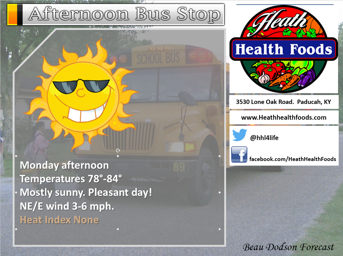
August 22, 2016
Monday – Sunny. Patchy morning fog possible. Cooler. Less humid.
What impact is expected? Patchy fog possible in the morning.
Temperatures: High temperatures in the 75-80 degree range.
Winds: North and northeast winds at 7-14 mph.
What is the chance for precipitation? 0%
Coverage of precipitation? None
Is severe weather expected? No
My confidence in this part of the forecast verifying: High. The forecast should verify.
Should I cancel my outdoor plans? No
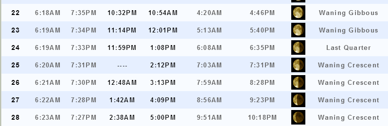
Sunrise will be at 6:18 a.m. and sunset will be at 7:35 p.m.
UV index will be 8-11. High.
Moonrise will be at 10:32 p.m. and moonset will be at 10:54 a.m. Waning Gibbous
.
Monday Night – Mostly clear. Patchy fog possible. Cooler.
What impact is expected? Most likely none.
Temperatures: Lows in the 54-60 degree range
Winds: Winds north and northeast at 3-6 mph.
What is the chance for precipitation? 0%
Coverage of precipitation: None
Is severe weather expected? No
My confidence in this part of the forecast verifying: High. The forecast should verify.
Should I cancel my outdoor plans? No
.
August 23, 2016
Tuesday – Sunny during the morning. Patchy morning fog possible. An overall decent day for most of the region. Some increase in clouds possible during the afternoon over our western counties in southeast Missouri and western Tennessee. There will be a chance for a couple of showers and thunderstorms over southeast Missouri and perhaps western Tennessee.
What impact is expected? Patchy fog possible in the morning. Small chance for lightning over southeast Missouri and perhaps western Tennessee.
Temperatures: High temperatures in the 75-80 degree range.
Winds: East and southeast winds becoming southwest winds at 4-8 mph.
What is the chance for precipitation? 30% for Missouri and Tennessee (further west you travel the better the chance for a shower or storm)
Coverage of precipitation? Perhaps a few showers or storms over southeast Missouri and western Tennessee.
Is severe weather expected? No
My confidence in this part of the forecast verifying: Medium. Some forecast adjustments might be required.
Should I cancel my outdoor plans? No
Sunrise will be at 6:13 a.m. and sunset will be at 7:34 p.m.
UV index will be 8-11. High.
Moonrise will be at 11:14 p.m. and moonset will be at 12:01 p.m. Waning Gibbous
.
Tuesday Night – Some increase in clouds. Slight chance for a shower or storms. Perhaps a little better chance in the Missouri Ozarks.
What impact is expected? Most likely none.
Temperatures: Lows in the 65-70 degree range
Winds: Winds southwest at 3-6 mph.
What is the chance for precipitation? 30% (mainly for southeast Missouri)
Coverage of precipitation: Perhaps an isolated shower or storm
Is severe weather expected? No
My confidence in this part of the forecast verifying: Medium. Some forecast adjustments might be required.
Should I cancel my outdoor plans? No
.
August 24, 2016
Wednesday – Partly sunny. A little bit warmer and more humid. A 20% for a shower or thunderstorm.
What impact is expected? Lightning and wet roadways
Temperatures: High temperatures in the 83-86 degree range.
Winds: Southwest winds at 7-14 mph.
What is the chance for precipitation? 20%
Coverage of precipitation? Isolated to Scattered
Is severe weather expected? No
My confidence in this part of the forecast verifying: Medium. Some forecast adjustments might be required.
Should I cancel my outdoor plans? No, but check radars.
Sunrise will be at 6:19 a.m. and sunset will be at 7:33 p.m.
UV index will be 8-11. High.
Moonrise will be at 11:59 p.m. and moonset will be at 1:08 p.m. Last quarter
.
Wednesday Night – Quite a few clouds. A shower or storm will be possible.
What impact is expected? Lightning and wet roadways.
Temperatures: Lows in the 70-75 degree range
Winds: Winds southwest at 3-6 mph.
What is the chance for precipitation? 30%
Coverage of precipitation: Scattered
Is severe weather expected? No, but check radars.
My confidence in this part of the forecast verifying: Medium. Some forecast adjustments might be required.
Should I cancel my outdoor plans? No
.
August 25, 2016
Thursday – Cloudy. A chance for showers and thunderstorms.
What impact is expected? Lightning and wet roadways.
Temperatures: High temperatures in the 84-86 degree range (locally higher)
Winds: Southwest winds at 5-10 mph.
What is the chance for precipitation? 30%-40%
Coverage of precipitation? Scattered to perhaps numerous.
Is severe weather expected? Unlikely, but monitor updates.
My confidence in this part of the forecast verifying: Medium. Some forecast adjustments might be required.
Should I cancel my outdoor plans? No, but check radars.
Sunrise will be at 6:20 a.m. and sunset will be at 7:31 p.m.
UV index will be 3-6. Low to perhaps moderate (depending on cloud cover).
Moonrise will be at — p.m. and moonset will be at 2:12 a.m. Waning crescent
.
Thursday Night – Cloudy. A chance for showers and thunderstorms.
What impact is expected? Lightning and wet roadways.
Temperatures: Lows in the 70-75 degree range
Winds: Winds southwest at 3-6 mph.
What is the chance for precipitation? 30%-40%
Coverage of precipitation: Scattered to perhaps numerous
Is severe weather expected? Unlikely, but monitor updates
My confidence in this part of the forecast verifying: Medium. Some forecast adjustments might be required.
Should I cancel my outdoor plans? No, but monitor radars.
.
Significant differences in the guidance packages for the weekend. Monitor updates.
August 26, 2016
Friday – Partly sunny. Warm. Humid. A chance for an isolated thunderstorm.
What impact is expected? Lightning and wet roadways.
Temperatures: High temperatures in the 84-88 degree range.
Winds: West and southwest winds at 5-10 mph.
What is the chance for precipitation? 20%-30%
Coverage of precipitation? Isolated to perhaps scattered
Is severe weather expected? No, but monitor updates.
My confidence in this part of the forecast verifying: Low. Significant adjustments are possible in the forecast.
Should I cancel my outdoor plans? No, but monitor radars.
Sunrise will be at 6:21 a.m. and sunset will be at 7:30 p.m.
UV index will be 3-6. Low to medium. This may need to be adjusted based on cloud cover.
Moonrise will be at 12:48 a.m. and moonset will be at 3:13 p.m. Waning crescent
.
Friday Night – Partly cloudy.
What impact is expected? Lightning and wet roadways.
Temperatures: Lows in the 66-72 degree range
Winds: Winds north and northwest at 3-6 mph.
What is the chance for precipitation? 20%
Coverage of precipitation:
Is severe weather expected? Unlikely
My confidence in this part of the forecast verifying: Low. Significant adjustments are possible in the forecast.
Should I cancel my outdoor plans?
.
August 27, 2016
Saturday – Partly cloudy.
What impact is expected? Lightning and wet roadways.
Temperatures: High temperatures in the 84-86 degree range.
Winds: Southwest winds at 7-14 mph.
What is the chance for precipitation? 20%
Coverage of precipitation?
Is severe weather expected? No
My confidence in this part of the forecast verifying: Low. Significant adjustments are possible in the forecast.
Should I cancel my outdoor plans?
Sunrise will be at 6:22 a.m. and sunset will be at 7:28 p.m.
UV index will be 4-8. Low to medium. We will need to monitor cloud cover.
Moonrise will be at 1:42 a.m. and moonset will be at 4:05 p.m. Waning crescent
.
Saturday Night – Partly cloudy.
What impact is expected? Lightning and wet roadways.
Temperatures: Lows in the 68-74 degree range
Winds: Winds southwest at 3-6 mph.
What is the chance for precipitation? 20%
Coverage of precipitation:
Is severe weather expected? No
My confidence in this part of the forecast verifying: Low. Significant adjustments are possible in the forecast.
Should I cancel my outdoor plans?
.
August 28, 2016
Sunday – Partly cloudy.
What impact is expected? Lightning and wet roadways.
Temperatures: High temperatures in the 82-86 degree range.
Winds: Southwest winds at 7-14 mph.
What is the chance for precipitation? 20%
Coverage of precipitation?
Is severe weather expected? No
My confidence in this part of the forecast verifying: Low. Significant adjustments are possible in the forecast.
Should I cancel my outdoor plans?
Sunrise will be at 6:23 a.m. and sunset will be at 7:27 p.m.
UV index will be 6-8. Moderate to perhaps high. Unsure about cloud cover.
Moonrise will be at 2:38 a.m. and moonset will be at 5:06 p.m. Waning crescent
.
Sunday Night – Partly cloudy.
What impact is expected? Lightning and wet roadways.
Temperatures: Lows in the 66-72 degree range
Winds: Winds west at 3-6 mph.
What is the chance for precipitation? 20%
Coverage of precipitation:
Is severe weather expected? No
My confidence in this part of the forecast verifying: Low. Significant adjustments are possible in the forecast.
Should I cancel my outdoor plans?
.More information on the UV index. Click here.
The School Bus Stop Forecast is sponsored by Heath Health and Wellness. Located next to Crowell Pools in Lone Oak, Kentucky.
Visit their web-site here. And. visit Heath Health Foods on Facebook!
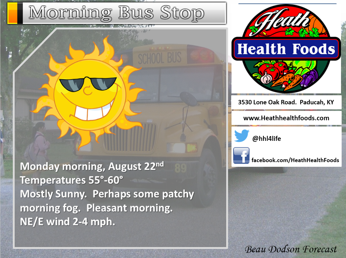

Heath Health Foods is a locally owned and operated retail health and wellness store. Since opening in February 2006; the store has continued to grow as a ministry with an expanding inventory which also offers wellness appointments and services along with educational opportunities. Visit their web-site here. And. visit Heath Health Foods on Facebook!
The weekend forecast is sponsored by Farmer and Company Real Estate.

Farmer & Company Real Estate is proud to represent buyers and sellers in both Southern Illinois and Western Kentucky. With 13 licensed brokers, we can provide years of experience to buyers & sellers of homes, land & farms and commercial & investment properties. We look forward to representing YOU! Follow us on Facebook, as well
The weekend forecast is sponsored by Farmer and Company Real Estate. Click here to visit their site.


Don’t forget to check out the Southern Illinois Weather Observatory web-site for weather maps, tower cams, scanner feeds, radars, and much more! Click here

An explanation of what is happening in the atmosphere over the coming days…
- Pleasant weather for Monday
- Isolated storm risk on Tuesday for mainly the Missouri Ozarks
- Monitoring rain chances for Wednesday into the weekend
- Some debate on the weekend forecast
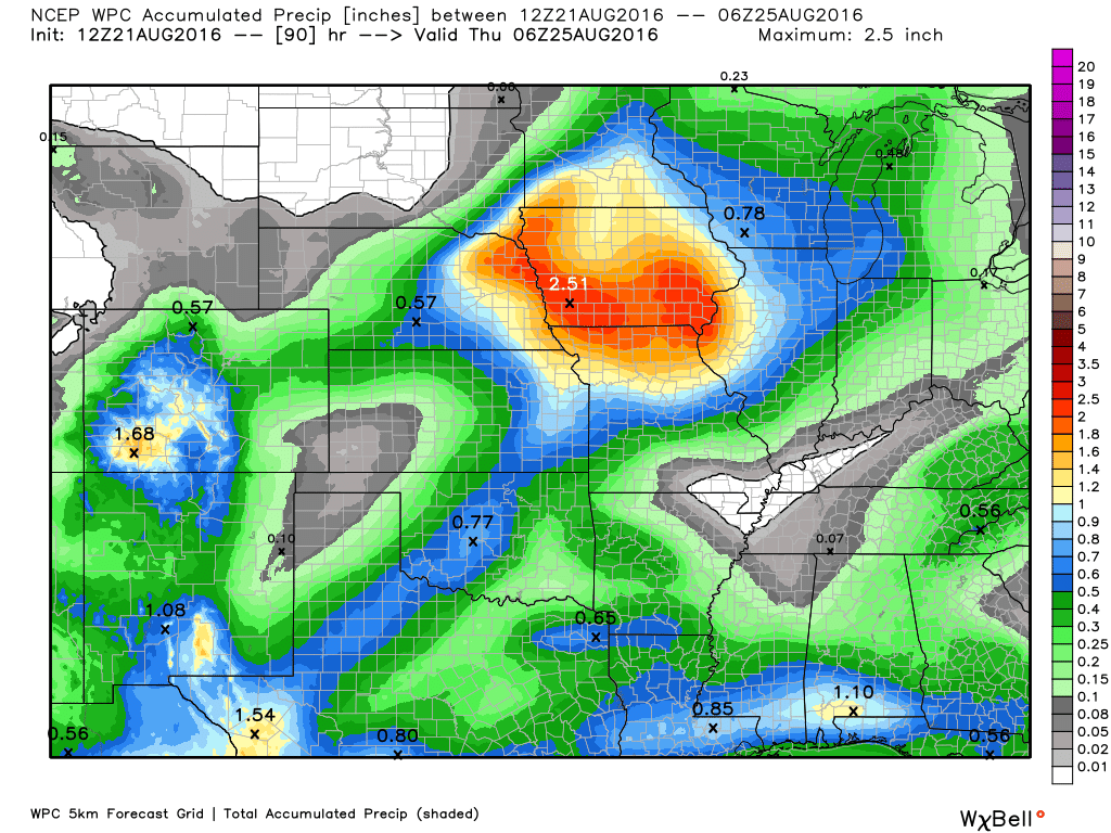
Well, the weekend was not too bad. At least Sunday! Saturday delivered showers and thunderstorms. There was some locally heavy rain, as well. The heaviest rain fell over portions of the Pennyrile area of western Kentucky. Some storms trained in that area on Saturday evening and night. A few spots picked up more than two inches of rain. Radar even showed a few patches of three and four inches of rain.
Here are the radar estimated rain totals. The scale is on the left side of the image. Click the image for a larger view.
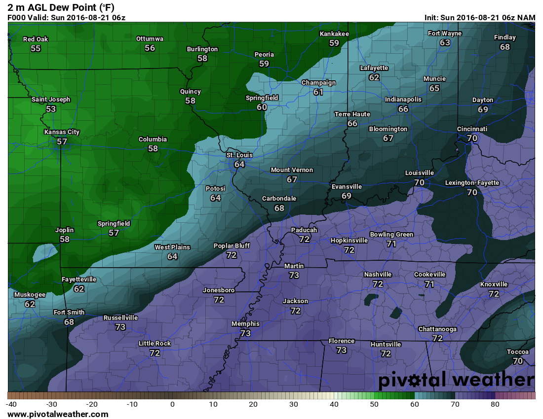
The cold front that delivered our rain has pushed off to the east. This has left a nice air-mass in its wake. I am sure everyone has enjoyed the lower dew points. Dew points have been in the 50’s and lower 60’s over the region since the front moved east.
This map shows you the higher dew point numbers on Sunday morning. Watch what happens by Monday afternoon.
This was before the front moved through the area (Sunday morning).
Click images to enlarge
And, Monday. See the difference?
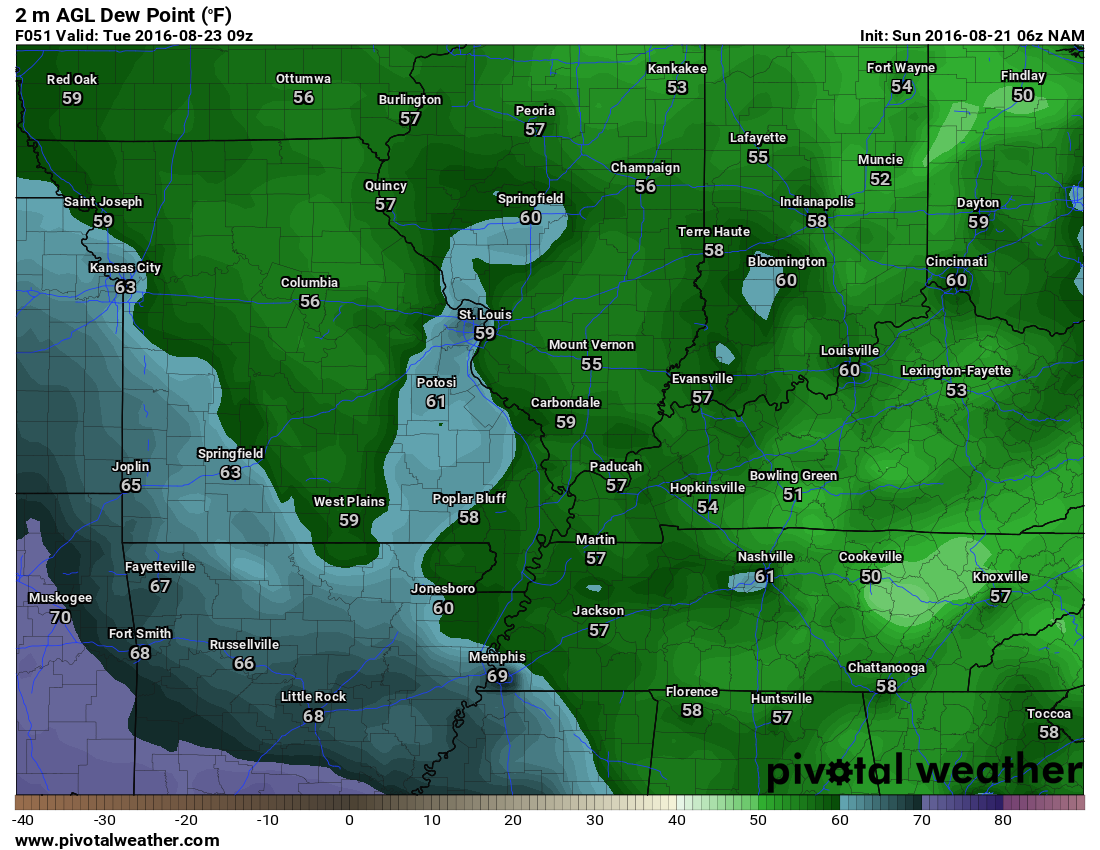
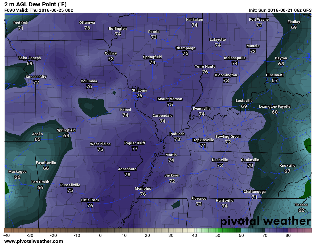
Watch what happens by Wednesday afternoon. Ick. Dew points are on the rise.
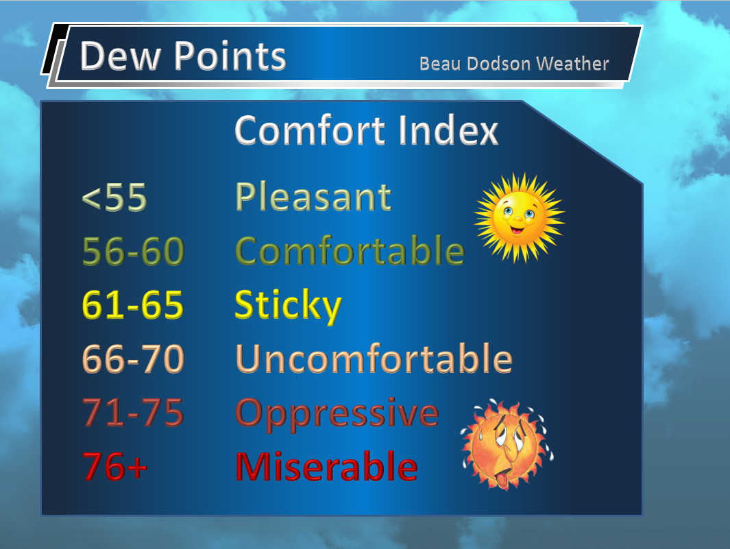
What are dew points?
What are dew points? Well, another great question. A lot of people confuse humidity and dew points. I like to use dew points to measure moisture in the air. This is the better way, actually. To learn more about dew points…click here
Click image to enlarge
We will see southerly and southwesterly winds return on Wednesday. That will mean rising dew points. The air will be moving northward from the Gulf of Mexico. A few scattered thunderstorms are possible as early as Tuesday over the Missouri Ozarks. Some guidance shows storms in the Missouri Bootheel and western Tennessee. This will need to be monitored. Lower confidence on that part of the forecast.
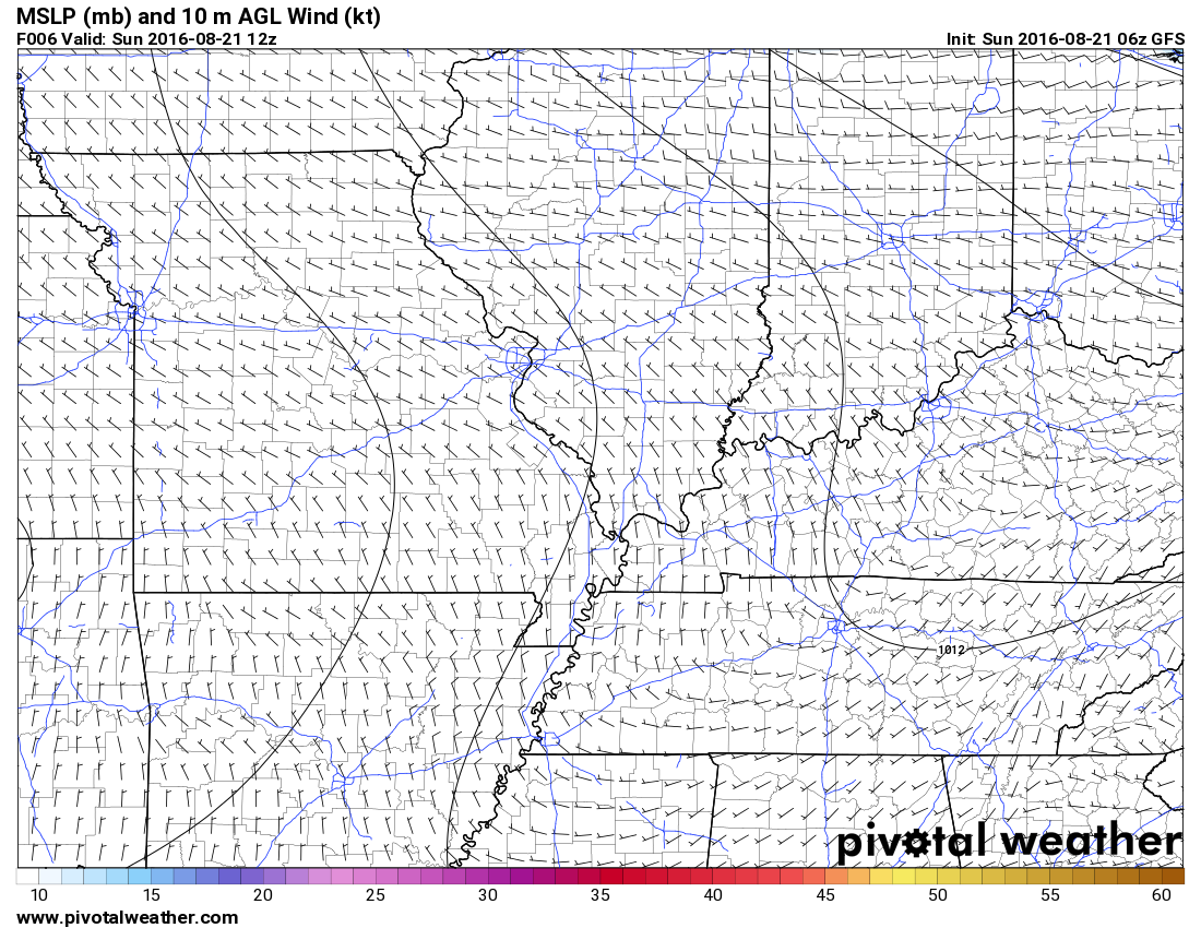
Here are the wind barbs from Sunday. Notice how they are from the north? The barb end of the arrow is the direction the air is moving in from. Mostly from the north and northwest.
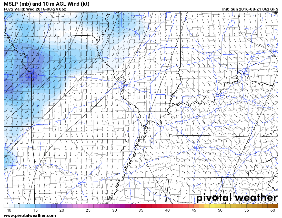
Now look at the map for Wednesday. The wind has turned and is now coming from the south. Air coming from the Gulf of Mexico and moving northward. Warmer and muggier air.
Dew points should return to the upper 60’s to middle 70’s on Wednesday into Friday. Scattered showers and thunderstorms will be possible in the region during this time frame. Perhaps the greatest probability for rain will arrive on Thursday. That leaves some question marks for Friday into Sunday. The GFS guidance and EC guidance does indicate at least some chance for storms Friday into Sunday. Let’s keep an eye on it. I am hoping that Saturday and Sunday will end up dry. No promises.
Let’s take a closer look at Tuesday into Wednesday.
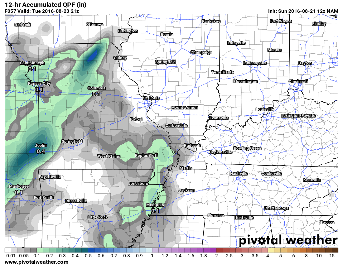
This graphic is from the NAM model guidance. The NAM is picking up on some scattered showers and thunderstorms on Tuesday. I do think there could be at least a few showers and storms over southeast Missouri on Tuesday and Tuesday night. I will keep an eye on it. There is some question about how far east the precipitation will drift.
Here are the NAM totals for Tuesday (morning and afternoon).
There is quite a bit of model disagreement about rain chances this week. For example, the Canadian GEM model is showing showers and storms in our region on Tuesday night and Wednesday morning. Here are the 12 hour rainfall totals from 6 PM Tuesday through 6 AM on Wednesday.
This seems a bit overdone considering the pattern.
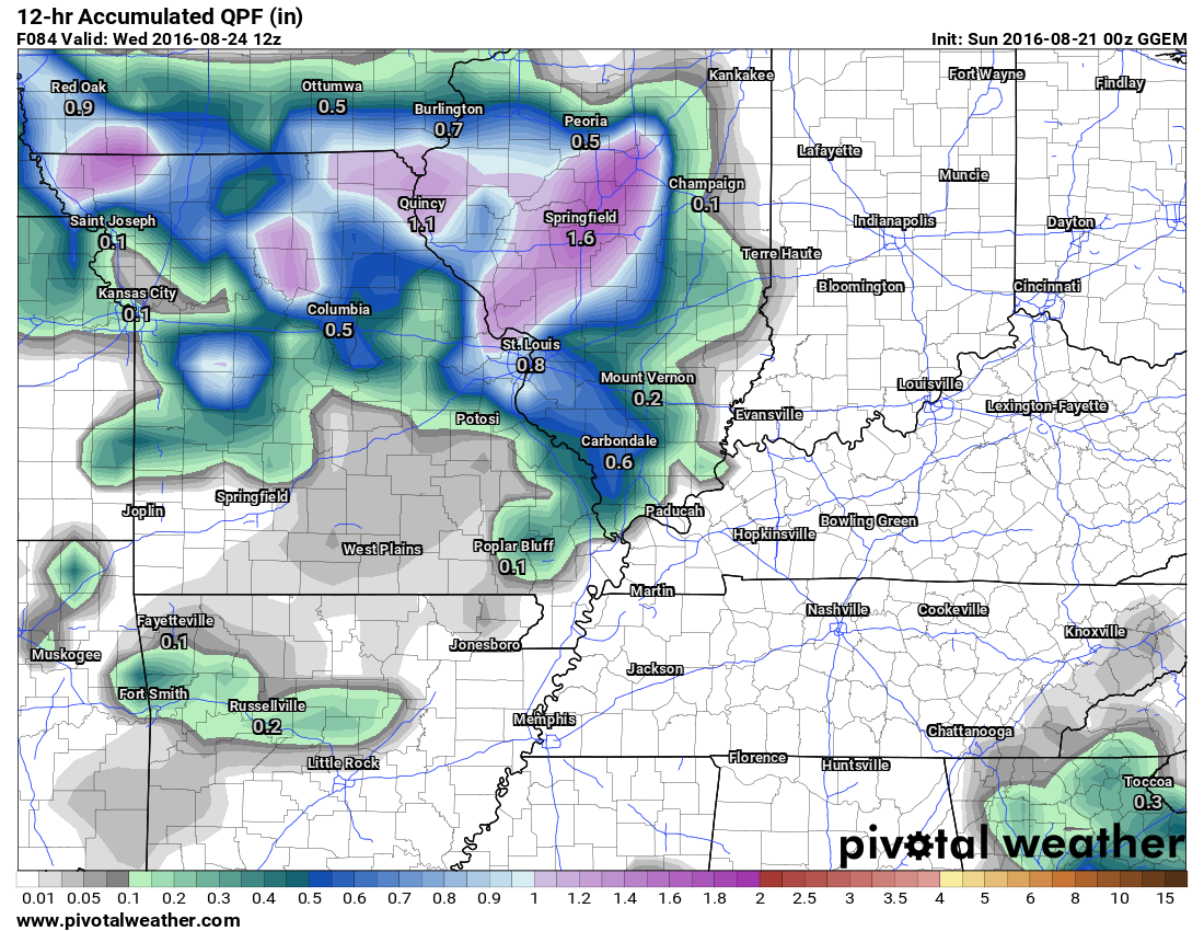
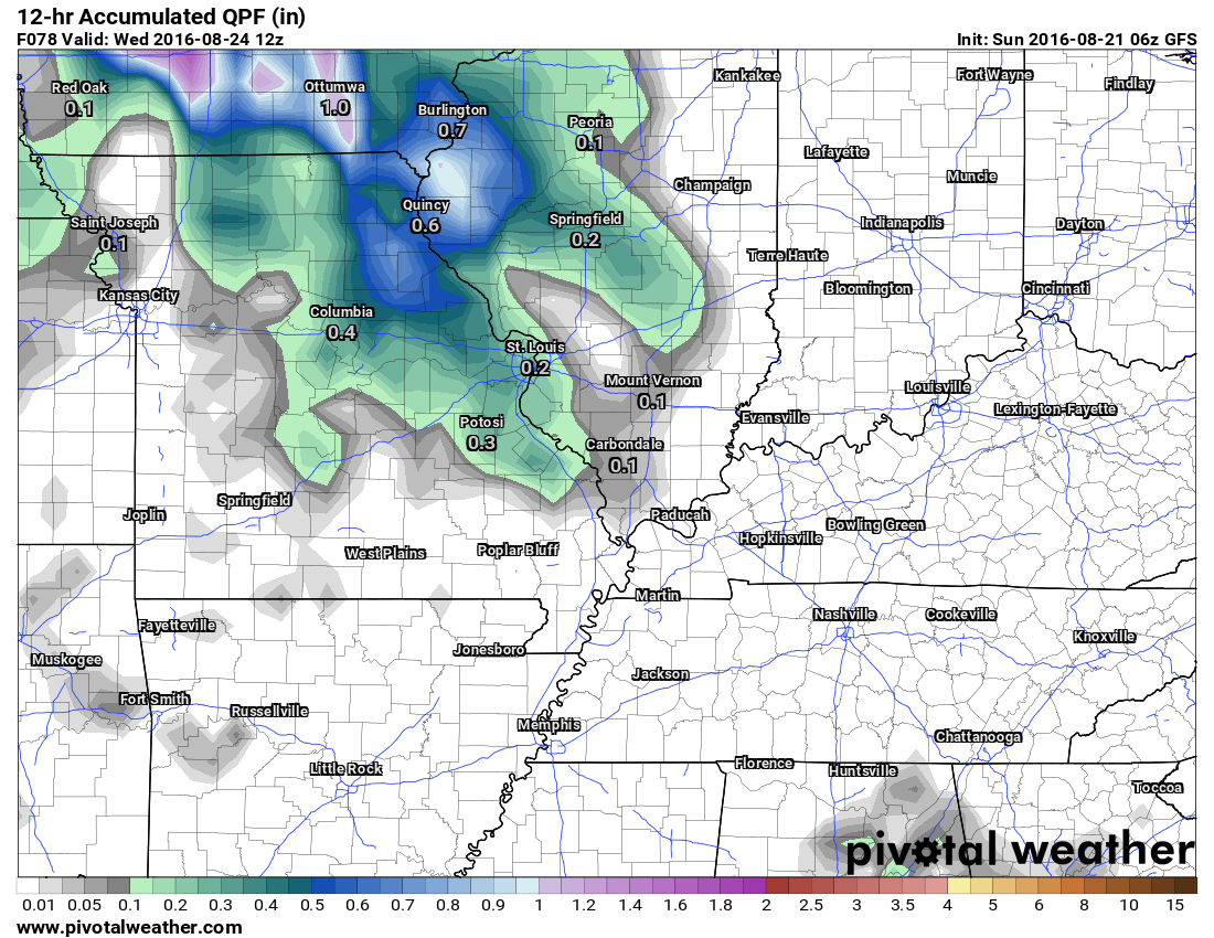
Let me show you the GFS American guidance for the same time period. The GFS is showing some precipitation in the region on Tuesday night and Wednesday morning. Perhaps centered over our western and northern counties. The totals are considerably less than what the GEM is showing.
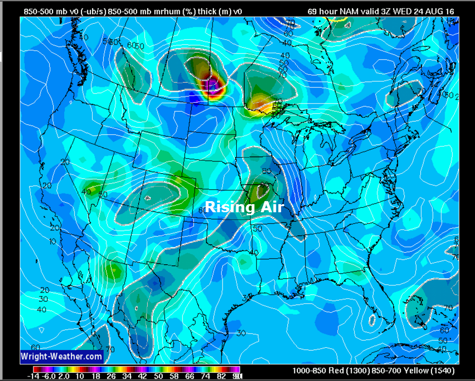
The NAM is showing rising air on Tuesday into Wednesday morning. The rising air is the hatched/shaded air. Rising air could mean shower and thunderstorm development.
Click image to enlarge
We will start the week with nice temperatures and low dew points. Temperatures will rise into the 80’s from Wednesday into the weekend. That combined with higher dew points will make it feel a bit warmer than the actual air temperatures. For now, I don’t see widespread 90’s in the upcoming short and medium range forecast. I can’t rule out some upper 80’s as we push deeper into the week and perhaps the weekend. This would especially be true if we don’t have a lot of cloud cover.
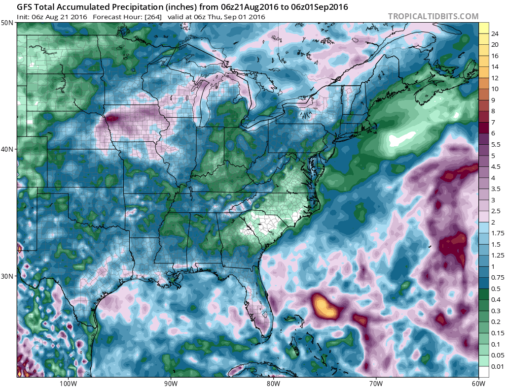
Let’s take a look at the GFS ten day rainfall map. You can see the heaviest precipitation is situated to our north and south. Notice the heavy rain off the East Coast? That is because of a possible tropical system being picked up by the GFS guidance. We will also need to monitor the Caribbean over the coming two week period. Might we see more tropical development in that part of the Atlantic? It is possible.
How much rain is forecast Monday into Wednesday?
This is broad-brushed. Totals will vary based on thunderstorm placement. Stronger storms can produce a quick one inch of rain.
We will have to watch Tuesday for a few showers/storms over mainly the Ozarks of southeast Missouri. Some guidance indicates a couple of showers or storms into the Missouri Bootheel and western Tennessee. Lower confidence on that part of the forecast.
A chance for a few scattered showers and storms in the region for Wednesday, as well.
Click image for a larger view.
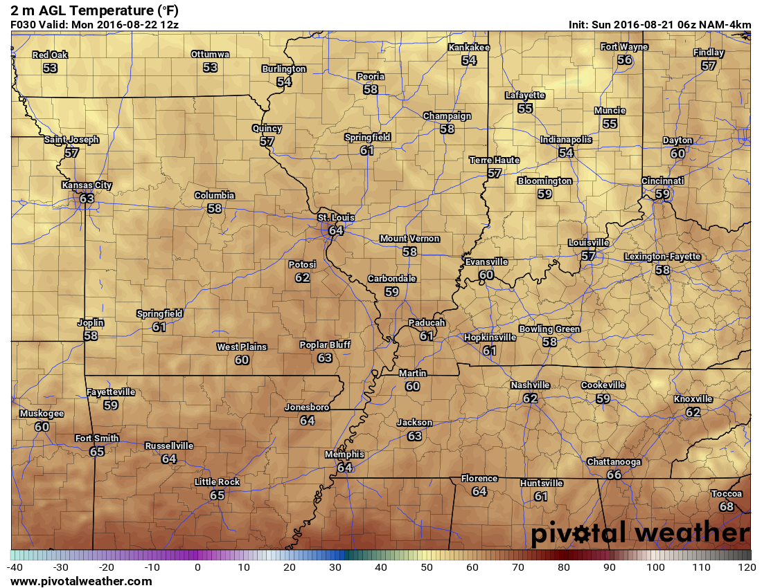
Monday morning low temperature map
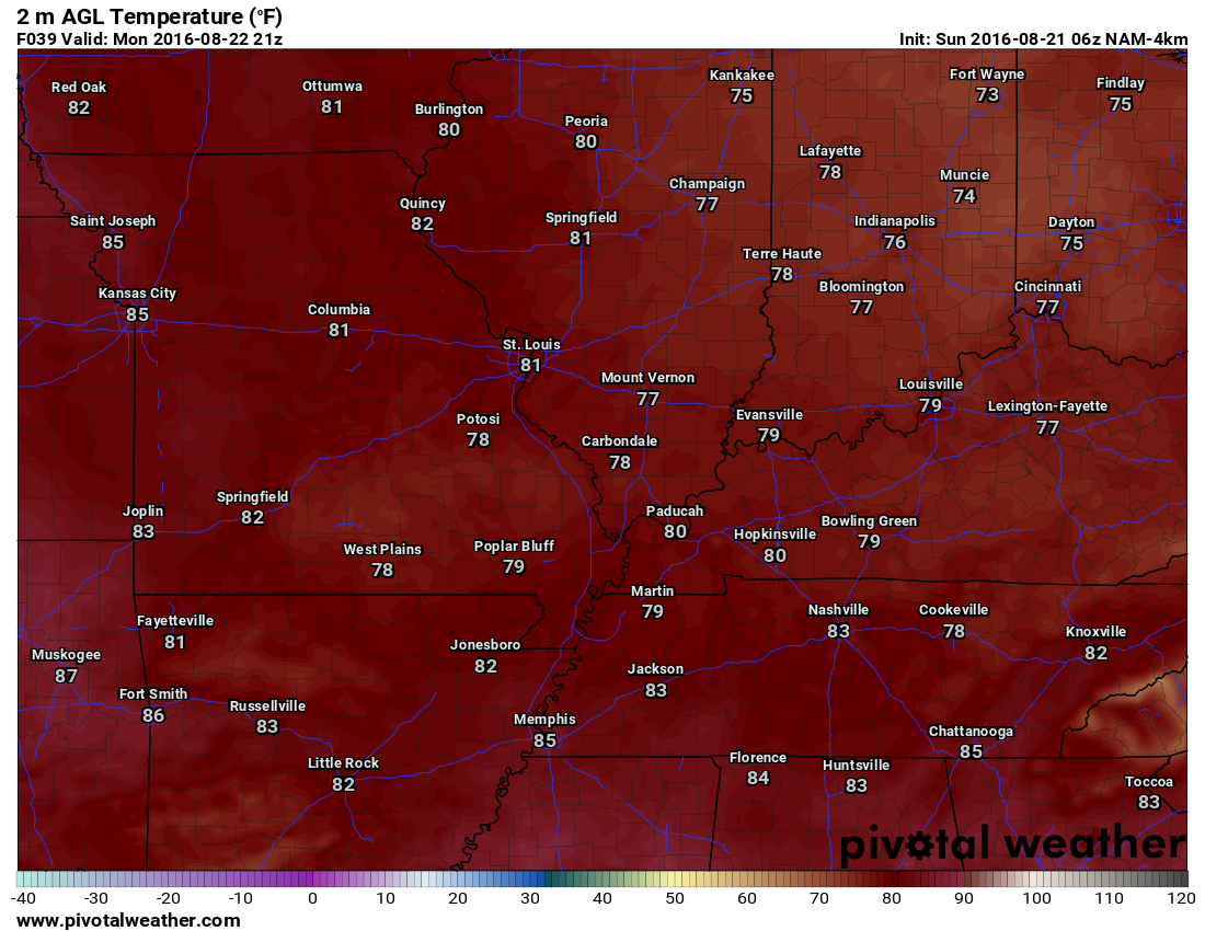
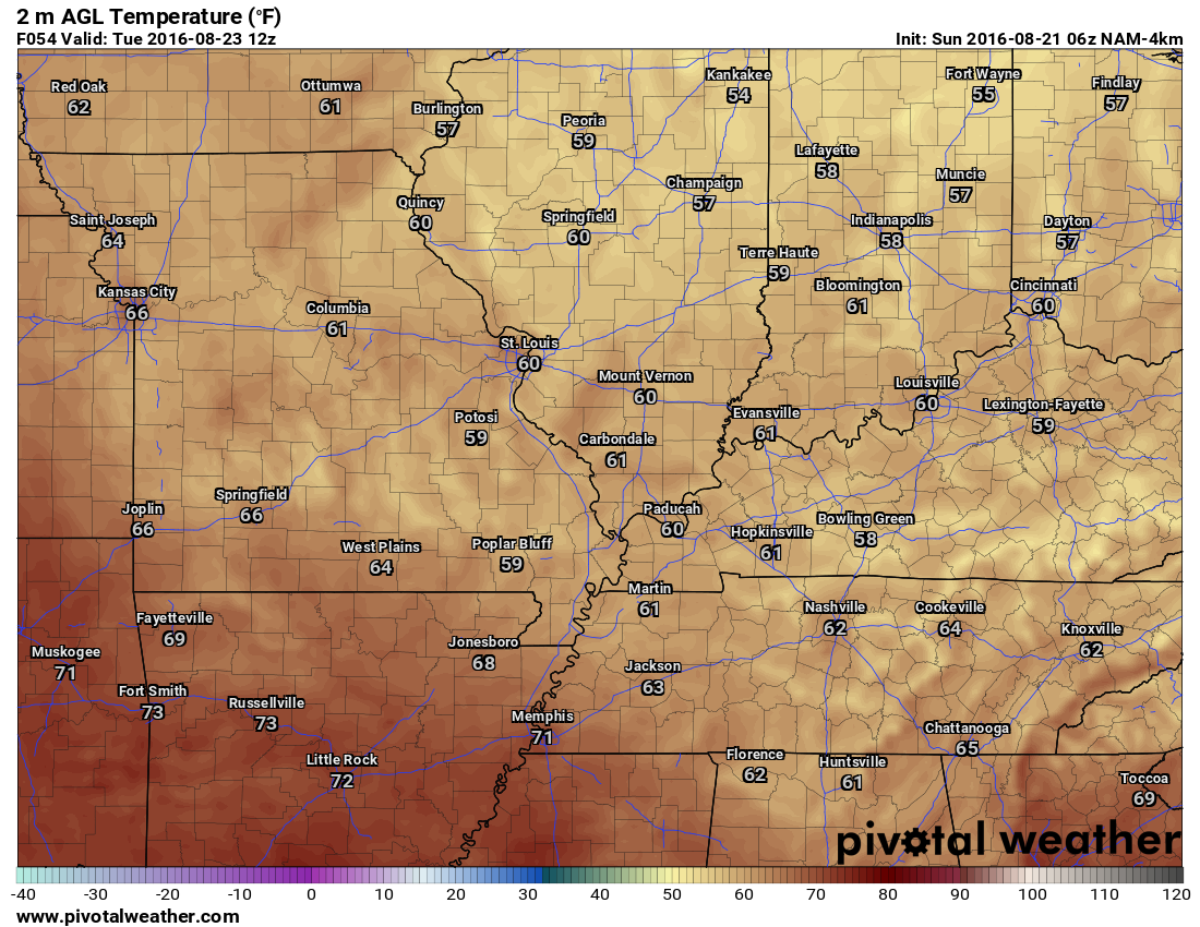
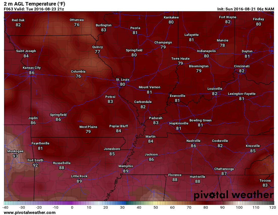
Click images to enlarge
Monday afternoon high temperatures
Tuesday morning low temperature map
Tuesday afternoon high temperature map
I will keep the Beau Dodson Weather Facebook page updated, Beau Dodson on Twitter, and the texts. Don’t forget if you want to receive links to the daily blog and Facebook updates to check box number four on the texting site. That is the one used for non-severe days.
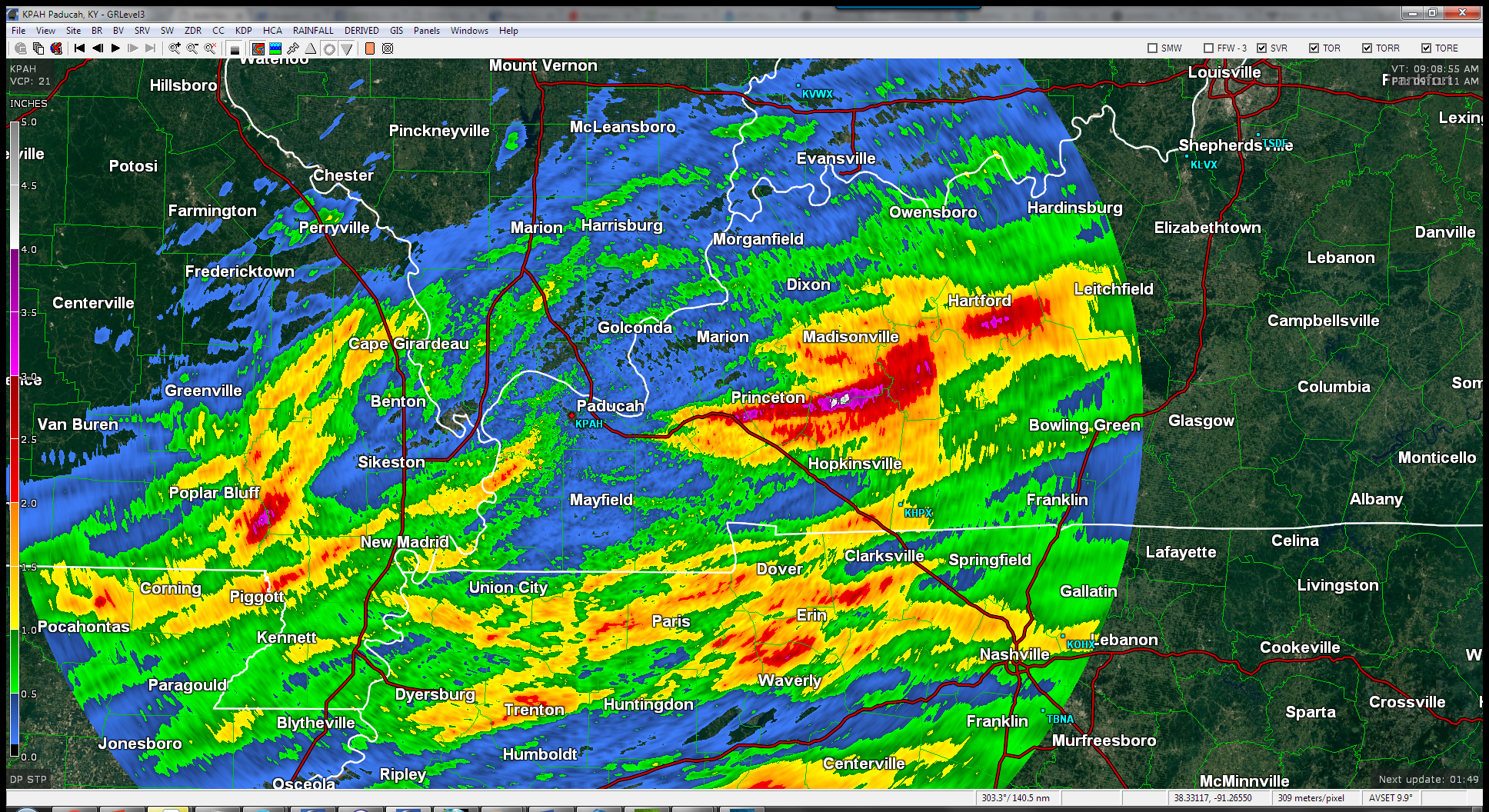
Storm Tracking Radar


We have regional radars and local city radars – if a radar does not seem to be updating then try another one. Occasional browsers need their cache cleared. You may also try restarting your browser. That usually fixes the problem. Occasionally we do have a radar go down. That is why I have duplicates. Thus, if one fails then try another one.
If you have any problems then please send me an email beaudodson@usawx.com
WEATHER RADAR PAGE – Click here —
We also have a new national interactive radar – you can view that radar by clicking here.
Local interactive city radars include St Louis, Mt Vernon, Evansville, Poplar Bluff, Cape Girardeau, Marion, Paducah, Hopkinsville, Memphis, Nashville, Dyersburg, and all of eastern Kentucky – these are interactive radars. Local city radars – click here

Live Lightning Data – zoom and pan: Click here
Live Lightning Data with sound (click the sound button on the left side of the page): Click here

Can we expect severe thunderstorms over the next 24 to 48 hours? Remember that a severe thunderstorm is defined as a thunderstorm that produces 58 mph winds or higher, quarter size hail or larger, and/or a tornado.
.
Sunday night into Tuesday: No severe weather anticipated. Isolated storms possible over southeast Missouri and perhaps western Tennessee.
Tuesday night: No severe weather anticipated. Isolated storms possible over southeast Missouri and perhaps western Tennessee.
Wednesday into Friday: I can’t rule out some thunderstorms. Severe weather is currently not anticipated. Monitor updated forecasts.
.

.
No major adjustments.
.

.
Rivers in some of our counties are flooding. Avoid flooded roadways.

.
No
.

Here are the current river stage forecasts. You can click your state and then the dot for your location. It will bring up the full forecast and hydrograph.
..

Here is the official 6-10 day and 8-14 day temperature and precipitation outlook. Check the date stamp at the top of each image (so you understand the time frame).
The forecast maps below are issued by the Weather Prediction Center (NOAA).


The latest 8-14 day temperature and precipitation outlook. Note the dates are at the top of the image. These maps DO NOT tell you how high or low temperatures or precipitation will be. They simply give you the probability as to whether temperatures or precipitation will be above or below normal.


Who do you trust for your weather information and who holds them accountable?
I have studied weather in our region since the late 1970’s. I have 37 years of experience in observing our regions weather patterns. My degree is in Broadcast Meteorology from Mississippi State University and an Associate of Science (AS). I am currently working on my Bachelor’s Degree in Geoscience.
My resume includes:
Member of the American Meteorological Society.
NOAA Weather-Ready Nation Ambassador.
Meteorologist for McCracken County Emergency Management. I served from 2005 through 2015.
I own and operate the Southern Illinois Weather Observatory.
Recipient of the Mark Trail Award, WPSD Six Who Make A Difference Award, Kentucky Colonel, and the Caesar J. Fiamma” Award from the American Red Cross.
In 2009 I was presented with the Kentucky Office of Highway Safety Award.
Recognized by the Kentucky House of Representatives for my service to the State of Kentucky leading up to several winter storms and severe weather outbreaks.
I am also President of the Shadow Angel Foundation which serves portions of western Kentucky and southern Illinois.
There is a lot of noise on the internet. A lot of weather maps are posted without explanation. Over time you should learn who to trust for your weather information.
My forecast philosophy is simple and straight forward.
- Communicate in simple terms
- To be as accurate as possible within a reasonable time frame before an event
- Interact with you on Twitter, Facebook, and the blog
- Minimize the “hype” that you might see on television or through other weather sources
- Push you towards utilizing wall-to-wall LOCAL TV coverage during severe weather events
I am a recipient of the Mark Trail Award, WPSD Six Who Make A Difference Award, Kentucky Colonel, and the Caesar J. Fiamma” Award from the American Red Cross. In 2009 I was presented with the Kentucky Office of Highway Safety Award. I was recognized by the Kentucky House of Representatives for my service to the State of Kentucky leading up to several winter storms and severe weather outbreaks.
If you click on the image below you can read the Kentucky House of Representatives Resolution.

Many of my graphics are from www.weatherbell.com – a great resource for weather data, model data, and more


You can sign up for my AWARE email by clicking here I typically send out AWARE emails before severe weather, winter storms, or other active weather situations. I do not email watches or warnings. The emails are a basic “heads up” concerning incoming weather conditions.