Sunday Facebook update https://wtalk.co/PFXAF29U
Severe Weather Outlook
Today through Monday night.
Isolated storms are possible. They are not anticipated to be severe. Lightning is the main concern. A few downpours. Gusty winds. Most areas will remain dry.
Tuesday and Tuesday night
A cold front enters our region with a chance for widespread showers and locally strong thunderstorms. Severe weather can’t be ruled out with the cold front. Monitor updates.
.
.
A few concerns remain.
First, let me say that it will be muggy through Monday night. Actual air temperatures today will range from 90 to 95. Isolated hotter areas possible.
Heat index values today of 98 to 106 degrees.
Heat index values on Monday of 96 to 104 degrees.
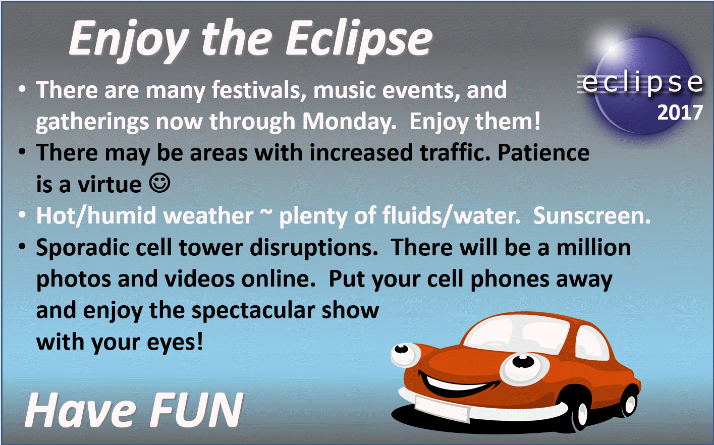
Obviously, heat related illnesses are a concern for outdoor gatherings. Especially true for tourists that have come into our region that may or may not be acclimated for these conditions.
Anyone in charge of outdoor events should have plenty of water on hand. Common sense heat safety rules.
A few thunderstorms are possible today into Monday. Many will remain dry.
Questions remain about cloud cover on Monday. The greatest cloud cover should be over portions of southeast Missouri and southern Illinois.
Two possible scenarios.
We have a thunderstorm complex over northern Missouri this morning. Satellite images indicate clouds moving northwest to southeast into our region. This will leave an outflow boundary later today (a boundary where old storms die off and new ones could form).
This boundary may ignite some storms later today/this afternoon. We already had a couple of showers/storms on radar over southeast Illinois/southwest Indiana.
Any showers and storms that do form today, mainly over southeast Missouri and southern Illinois, will weaken during the evening. That will leave some high clouds in the region.
Later tonight, another thunderstorm complex is likely to form over northeast Kansas, Iowa, and northern Missouri. The timing of that thunderstorm complex is key to our forecast. How far south it forms is also important.
Wind fields today are oriented such that clouds are moving northwest to southeast. On Monday, however, the wind fields aloft will be a bit more west to east.
Some of those clouds will likely impact at least portions of southeast Missouri and southern Illinois.
How fast we heat up on Monday morning will be key to new cumulus clouds forming. Typically, during the heat of the day, you see cumulus clouds bubble up as heat rises from the warming earth/ground temperatures. These air parcels rise and as they rise they expand and cool. Eventually the air parcels reach the condensation level and form clouds.
The forecast remains unchanged. A mix of sun and clouds, especially over Missouri and Illinois. Better chances for less clouds over Kentucky and Tennessee.
.
.


Videos can be viewed at this link. Long Range Video Update
If you believe you missed a video then you can also click the LIVE FEED link on the Weather Talk website. That page holds links for several days.
I can text you the videos, as well. Make sure you have text option FOUR turned on. That would be the Weather Extra text option. Sign up for the text messages at www.beaudodsonweather.com
.

.
This forecast update covers southern Illinois, southeast Missouri, western Kentucky. and northwest Tennessee.
.
The following link is for Weather Text subscribers. This is the page where short and long range video outlooks have been posted. The videos are being produced by a team of meteorologists. Some of the best in the region.
https://weathertalk.com/app/beaucast
.
August 19, 2017
Saturday Night Forecast Details:
Forecast: Partly cloudy during the evening, then clearing. An evening shower or thunderstorm possible. Patchy fog possible.
Temperatures: MO ~ 66 to 72 IL ~ 66 to 72 KY ~ 66 to 72 TN ~ 66 to 72
Winds: Variable at 0 to 6 mph
What impacts are anticipated from the weather? Patchy dense fog possible. Isolated evening wet roadways and lightning possible.
My confidence in the forecast verifying: High. This forecast should verify.
Is severe weather expected? No
The NWS defines severe weather as 58 mph winds or great, 1″ hail or larger, and/or tornadoes
What is the chance of precipitation? MO ~ 10% to 20% IL ~ 10% to 20% KY ~ 10% to 20% TN ~ 10% to 20%
Coverage of precipitation: Isolated
Should I cancel my outdoor plans? No, but check radars
.
August 20, 2017
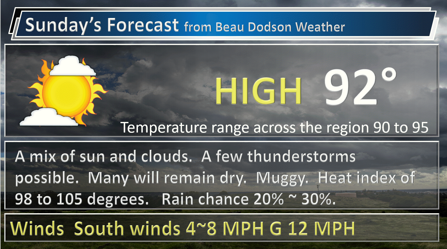
Sunday Forecast Details
Forecast: Mostly sunny. Hot. Muggy. Cumulus clouds developing. An isolated storm possible. Heat index values of 100 to 106 degrees.
Temperatures: MO ~ 90 to 95 IL ~ 90 to 95 KY ~ 90 to 95 TN ~ 90 to 95
Winds: Variable at 4 to 8 mph. Winds mostly from the south.
What impacts are anticipated from the weather? Isolated wet roadways and lightning.
My confidence in the forecast verifying: High. This forecast should verify.
Is severe weather expected? No
The NWS defines severe weather as 58 mph winds or great, 1″ hail or larger, and/or tornadoes
What is the chance of precipitation? MO ~ 10% to 20% IL ~ 10% to 20% KY ~ 10% to 20% TN ~ 10% to 20%
Coverage of precipitation: None to isolated.
Should I cancel my outdoor plans? No
.
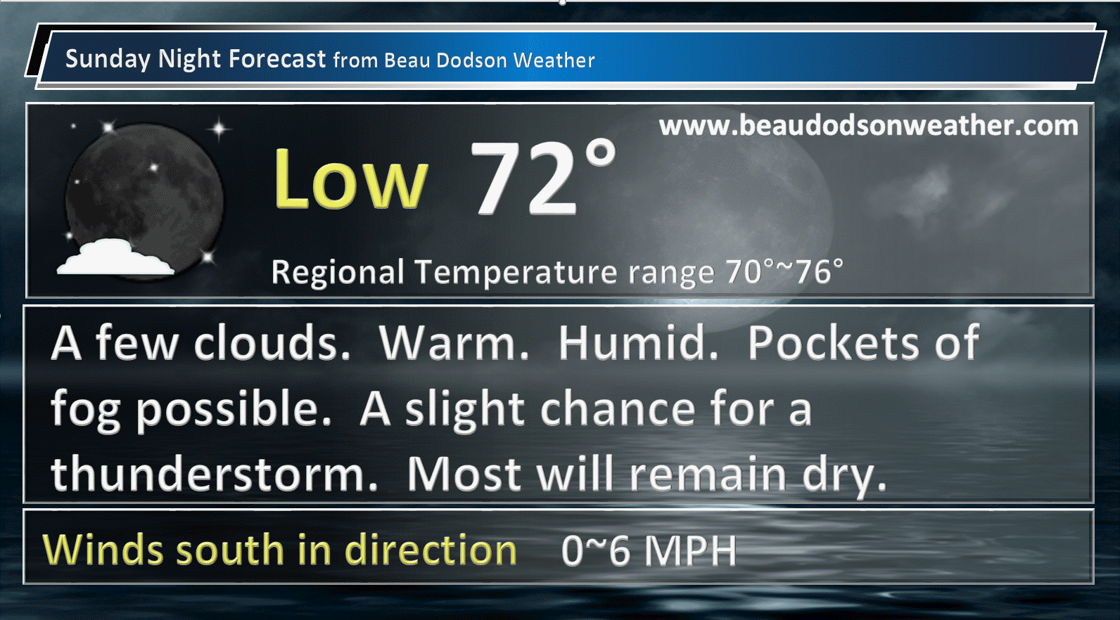
Sunday Night Forecast Details:
Forecast: Mostly clear. Mild. Patchy fog possible. Perhaps an isolated evening storm.
Temperatures: MO ~ 70 to 74 IL ~ 70 to 74 KY ~ 70 to 74 TN ~ 70 to 74
Winds: Light and variable <8 mph.
What impacts are anticipated from the weather? Most likely none. Perhaps patchy fog. Small chance for wet roadways and lightning.
My confidence in the forecast verifying: Medium. Some adjustments are possible
Is severe weather expected? No
The NWS defines severe weather as 58 mph winds or great, 1″ hail or larger, and/or tornadoes
What is the chance of precipitation? MO ~ 10% IL ~ 10% KY ~ 20% TN ~ 20%
Coverage of precipitation: None
Should I cancel my outdoor plans? No
.
August 21, 2017
Eclipse Day
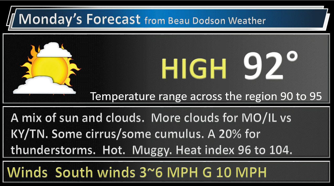
The main concern for Monday will be clouds. Confidence on cloud coverage remains rather low. Confidence in the overall forecast is medium.
Monday Forecast Details
Forecast: Southeast Missouri and southern Illinois will have a mix of sun and clouds. There are concerns about cloud cover. Scattered storms forming. Kentucky and northwest Tennessee will likely have more sun early on, but some cumulus clouds may develop as we heat up. It will be hot and muggy. Heat index values above 100 degrees. Use care.
Temperatures: MO ~ 88 to 94 IL ~ 88 to 94 KY ~ 88 to 94 TN ~ 88 to 94
Winds: South and southwest at less than 10 mph.
What impacts are anticipated from the weather? High heat index values. Perhaps isolated to scattered wet roadways and lightning.
My confidence in the forecast verifying: Medium. Some adjustments are possible
Is severe weather expected? No
The NWS defines severe weather as 58 mph winds or great, 1″ hail or larger, and/or tornadoes
What is the chance of precipitation? MO ~ 30% to perhaps 40% northern counties IL ~ 30% KY ~ 20% TN ~ 20%
Coverage of precipitation: Isolated to scattered. Greatest chance over southeast Missouri and southern Illinois.
Should I cancel my outdoor plans? No, but check radars and updated forecast numbers.
.
Monday Night Forecast Details:
Forecast: Partly cloudy. A slight chance for an evening thunderstorm.
Temperatures: MO ~ 68 to 74 IL ~ 68 to 74 KY ~ 68 to 74 TN ~ 68 to 74
Winds: South and southwest at 4 to 8 mph
What impacts are anticipated from the weather? Most likely none. Isolated wet roadways and lightning.
My confidence in the forecast verifying: Medium. Some adjustments possible.
Is severe weather expected? Not at this time
The NWS defines severe weather as 58 mph winds or great, 1″ hail or larger, and/or tornadoes
What is the chance of precipitation? MO ~ 30% IL ~ 30% KY ~ 30% TN ~ 20%
Coverage of precipitation: Scattered
Should I cancel my outdoor plans? No, but check radars
.
August 22, 2017
Tuesday Forecast Details
Forecast: Increasing clouds. Thunderstorms developing, especially during the afternoon. Warm. Humid.
Temperatures: MO ~ 86 to 90 IL ~ 86 to 90 KY ~ 86 to 90 TN ~ 86 to 90
Winds: South and southwest at 5 to 10 mph
What impacts are anticipated from the weather? Lightning. Gusty winds. Heavy downpours.
My confidence in the forecast verifying: Medium. Some adjustments are possible.
Is severe weather expected? Strong storms are possible. Monitor updated forecasts.
The NWS defines severe weather as 58 mph winds or great, 1″ hail or larger, and/or tornadoes
What is the chance of precipitation? MO ~ 60% IL ~ 60% KY ~ 60% TN ~ 60%
Coverage of precipitation: Scattered to perhaps numerous, depending on the timing of the cold front.
Should I cancel my outdoor plans? Check radars and updated forecast numbers.
.
Tuesday Night Forecast Details:
Forecast: Cloudy. Showers and thunderstorms likely. A few heavy storms possible.
Temperatures: MO ~ 68 to 74 IL ~ 68 to 74 KY ~ 68 to 74 TN ~ 68 to 74
Winds: South and southwest at 4 to 8 mph
What impacts are anticipated from the weather? Scattered wet roadways and lightning.
My confidence in the forecast verifying: Low. Significant adjustments possible.
Is severe weather expected? Strong storms are possible.
The NWS defines severe weather as 58 mph winds or great, 1″ hail or larger, and/or tornadoes
What is the chance of precipitation? MO ~ 60% IL ~ 60% KY ~ 60% TN ~ 60%
Coverage of precipitation: Scattered to perhaps numerous (depending on when the front arrives)
Should I cancel my outdoor plans? Monitor updates. Storms are possible.
.
.
August 23, 2017
Wednesday Forecast Details
Forecast: Some clouds. A chance for morning showers and thunderstorms. Cooler and less humid.
Temperatures: MO ~ 80 to 85 IL ~ 80 to 85 KY ~80 to 85 TN ~80 to 85
Winds: Northerly winds at 6 to 12 mph
What impacts are anticipated from the weather?
My confidence in the forecast verifying: Low. Significant adjustments are possible
Is severe weather expected?
The NWS defines severe weather as 58 mph winds or great, 1″ hail or larger, and/or tornadoes
What is the chance of precipitation? MO ~ 30% IL ~ 30% KY ~ 30% TN ~ 30%
Coverage of precipitation:
Should I cancel my outdoor plans?
.
Wednesday Night Forecast Details:
Forecast: Clearing and cooler. Less humid. Patchy fog possible.
Temperatures: MO ~ 58 to 64 IL ~ 58 to 64 KY ~ 58 to 64 TN ~ 58 to 64
Winds: Northerly winds 5 to 10 mph
What impacts are anticipated from the weather? Most likely none. Patchy fog perhaps.
My confidence in the forecast verifying: Low. Significant adjustments possible.
Is severe weather expected? No
The NWS defines severe weather as 58 mph winds or great, 1″ hail or larger, and/or tornadoes
What is the chance of precipitation? MO ~ 10% IL ~ 10% KY ~ 10% TN ~ 10%
Coverage of precipitation: Most likely none.
Should I cancel my outdoor plans? No
.

Don’t forget to check out the Southern Illinois Weather Observatory web-site for weather maps, tower cams, scanner feeds, radars, and much more! Click here

A severe thunderstorm is defined as a storm that produces quarter size hail or larger, 58 mph winds or greater, and/or a tornado. That is the official National Weather Service definition of a severe thunderstorm
Sunday: A 20% to 30% chances for showers and thunderstorms. That means there will likely be a few showers and storms on radar, but many will remain dry. Saturday morning storms could be intense.
Monday will be warm and humid. A few thunderstorms are possible. Severe weather is unlikely.
Tuesday will be warm with a cold front moving into the area. Strong storms are likely along the front, but timing of the front is still in question. It could arrive Tuesday night. Monitor updates concerning Tuesday.
Lightning will be the main concern over the coming days. Small risk for strong winds with the most intense thunderstorms. Locally heavy downpours.

Short update. Today is a travel day for me.
Heat is a concern for Sunday and Monday. Heat index values of 100 to 105 will likely occur during peak heating. Use care.

Are you subscribing to the Weather Talk texts and videos?
We now have premiere videos for the short and long range forecasts! Make sure you have text option four turned on (green).
Sign up at www.beaudodsonweather.com
We also have an Apple and Android app (scroll down to bottom of the page for more information)

Were you aware that I have hired some help for long range videos? Short range videos, as well. An amazing team of meteorologists.
Click the link below to read more
http://cms.weathertalk.com/meet-the-team/
Weather Talk subscribers now have some of the best short and long range weather videos produced across the eastern United States.
.

Find me on Twitter
.

We have regional radars and local city radars – if a radar does not update then try another one. Occasional browsers need their cache cleared. You may also try restarting your browser. That usually fixes the problem. Occasionally we do have a radar go down. That is why I have duplicates. Thus, if one fails then try another one.
During the winter you can track snow and ice by clicking the winterize button on the local city view interactive radars.
If you have any problems then please send me an email beaudodson@usawx.com
Interactive Weather Radar Page. Choose the city nearest your location: Click this link—
National interactive radar: Click this link.
Local interactive city radars include St Louis, Mt Vernon, Evansville, Poplar Bluff, Cape Girardeau, Marion, Paducah, Hopkinsville, Memphis, Nashville, Dyersburg, and all of eastern Kentucky. These are interactive radars. Local city radars – click here
The Beau Dodson Weather APP is ready for Apple and Android users. The purpose of this app is for me to deliver your text messages instantly. ATT and Verizon have not always been reliable when it comes to speed. The app allows instant delivery.
Some of you have asked if you can keep receiving the texts on your phone and the app. The answer to that is, yes. The Android app will automatically allow that to happen. On the Apple app, however, you will need to go into your app and click settings. Make sure the green tab is OFF. Off means you will still receive the texts to your phone and the app. If you have any questions, then email me at beaudodson@usawx.com
The app is for text subscribers.
The direct download, for the Apple app, can be viewed here
https://itunes.apple.com/us/app/id1190136514
If you have not signed up for the texting service then you may do so at www.beaudodsonweather.com

The Android app is also ready.
Remember, the app’s are for www.weathertalk.com subscribers. The app allows your to receive the text messages faster than ATT and Verizon.
Here is the download link for the Android version Click Here

——————————————————–
If you have not signed up for the texts messages, then please do. Link www.beaudodsonweather.com
Your support helps with the following:

and


Who do you trust for your weather information and who holds them accountable?
I have studied weather in our region since the late 1970’s. I have 39 years of experience in observing our regions weather patterns. My degree is in Broadcast Meteorology and a Bachelor’s of Science.
My resume includes:
Member of the American Meteorological Society.
NOAA Weather-Ready Nation Ambassador.
Meteorologist for McCracken County Emergency Management. I served from 2005 through 2015.
Meteorologist for McCracken County Rescue. 2015 through current
I own and operate the Southern Illinois Weather Observatory.
I am the chief meteorologist for Weather Talk LLC. I am the owner of Weather Talk LLC.
I am also a business owner in western Kentucky.
Recipient of the Mark Trail Award, WPSD Six Who Make A Difference Award, Kentucky Colonel, and the Caesar J. Fiamma” Award from the American Red Cross.
In 2005 I helped open the largest American Cross shelter in U.S. history in Houston, Texas. I was deployed to help after Hurricane Katrina and Hurricane Rita. I was a shelter manager of one of the Houston, Texas shelter divisions.
In 2009 I was presented with the Kentucky Office of Highway Safety Award.
Recognized by the Kentucky House of Representatives for my service to the State of Kentucky leading up to several winter storms and severe weather outbreaks.
If you click on the image below you can read the Kentucky House of Representatives Resolution.

I am also President of the Shadow Angel Foundation which serves portions of western Kentucky and southern Illinois.
There is a lot of noise on the internet. A lot of weather maps are posted without explanation. Over time you should learn who to trust for your weather information.
My forecast philosophy is simple and straight forward.
- Communicate in simple terms
- To be as accurate as possible within a reasonable time frame before an event
- Interact with you on Twitter, Facebook, email, texts, and this blog
- Minimize the “hype” that you might see on some television stations or through other weather sources
- Push you towards utilizing wall-to-wall LOCAL TV coverage during severe weather events
Many of the graphics on this page are from www.weatherbell.com
WeatherBell is a great resource for weather model guidance.


You can sign up for my AWARE email by clicking here I typically send out AWARE emails before severe weather, winter storms, or other active weather situations. I do not email watches or warnings. The emails are a basic “heads up” concerning incoming weather conditions