


Videos can be viewed at this link. Long Range Video Update
If you believe you missed a video then you can also click the LIVE FEED link on the Weather Talk website. That page holds links for several days.
I can text you the videos, as well. Make sure you have text option FOUR turned on. That would be the Weather Extra text option. Sign up for the text messages at www.beaudodsonweather.com
.

.
This forecast update covers southern Illinois, southeast Missouri, western Kentucky. and northwest Tennessee.
.
The following link is for Weather Text subscribers. This is the page where short and long range video outlooks have been posted. The videos are being produced by a team of meteorologists. Some of the best in the region.
https://weathertalk.com/app/beaucast
.
August 18, 2017
Friday Night Forecast Details:
Forecast: Mostly clear the first half of tonight. Some increase in clouds late. A chance for a few showers and thunderstorms over southeast Missouri and southwest Illinois. Most of the area should remain dry. It will be mild. Patchy fog possible.
Temperatures: MO ~ 64 to 68 IL ~ 64 to 68 KY ~ 64 to 68 TN ~ 64 to 68
Winds: South and southwest winds at 0 to 6 mph
What impacts are anticipated from the weather? Patchy fog possible. Perhaps some wet roadways and lightning (mainly over southeast MO and southwest IL).
My confidence in the forecast verifying: Medium. Some adjustments are possible
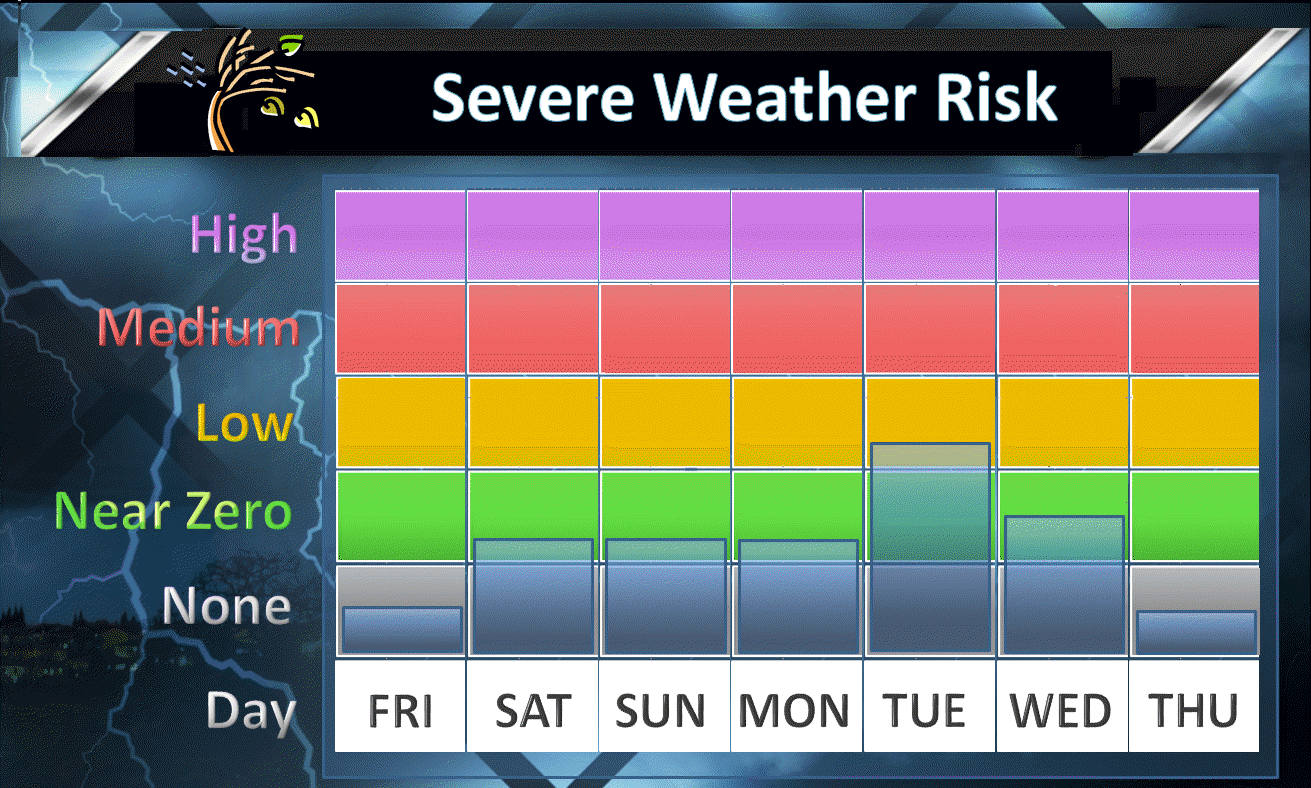
Is severe weather expected? Low end risk. Hail is the main concern and gusty winds.
The NWS defines severe weather as 58 mph winds or great, 1″ hail or larger, and/or tornadoes
What is the chance of precipitation? MO ~ 30% IL ~ 30% KY ~ 20% TN ~ 20%
Coverage of precipitation: Scattered possible late tonight.
Should I cancel my outdoor plans? No
.
August 19, 2017
Saturday Forecast Details
Forecast: Partly to mostly sunny. Isolated showers and thunderstorms possible. A bit warmer. A bit more humid.
Temperatures: MO ~ 85 to 90 IL ~ 85 to 90 KY ~ 85 to 90 TN ~ 85 to 90
Winds: Variable at 4 to 8 mph. Winds becoming west and perhaps northwest.
What impacts are anticipated from the weather? Scattered wet roads and lightning.
My confidence in the forecast verifying: Medium. Some adjustments are possible.
Is severe weather expected? Early morning storms could be intense.
The NWS defines severe weather as 58 mph winds or great, 1″ hail or larger, and/or tornadoes
What is the chance of precipitation? MO ~ 30% IL ~ 30% KY ~ 30% TN ~ 30%
Coverage of precipitation: Isolated to scattered
Should I cancel my outdoor plans? No, but check radars
.
Saturday Night Forecast Details:
Forecast: Partly cloudy during the evening, then clearing. An evening shower or thunderstorm possible. Patchy fog possible.
Temperatures: MO ~ 64 to 68 IL ~ 64 to 68 KY ~ 64 to 68 TN ~ 64 to 68
Winds: Variable at 0 to 6 mph
What impacts are anticipated from the weather? Patchy dense fog possible. Isolated evening wet roadways and lightning possible.
My confidence in the forecast verifying: Medium. Some adjustments are possible.
Is severe weather expected? No
The NWS defines severe weather as 58 mph winds or great, 1″ hail or larger, and/or tornadoes
What is the chance of precipitation? MO ~ 10% to 20% IL ~ 10% to 20% KY ~ 10% to 20% TN ~ 10% to 20%
Coverage of precipitation: Isolated early if any at all.
Should I cancel my outdoor plans? No, but check radars
.
August 20, 2017
Sunday Forecast Details
Forecast: A mix of sun and clouds. Isolated showers or thunderstorms possible. Warm and muggy. One guidance package has more clouds in the region on Sunday than another package. I will go with partly cloudy, for now.
Temperatures: MO ~ 85 to 90 IL ~ 85 to 90 KY ~ 85 to 90 TN ~ 85 to 90
Winds: Variable at 4 to 8 mph. Winds becoming east and southeast.
What impacts are anticipated from the weather? Isolated wet roadways and lightning.
My confidence in the forecast verifying: High. This forecast should verify.
Is severe weather expected? No
The NWS defines severe weather as 58 mph winds or great, 1″ hail or larger, and/or tornadoes
What is the chance of precipitation? MO ~ 20% IL ~ 20% KY ~ 20% TN ~ 20%
Coverage of precipitation: None to isolated.
Should I cancel my outdoor plans? No
.
Sunday Night Forecast Details:
Forecast: Mostly clear. Mild. Fog possible.
Temperatures: MO ~ 65 to 70 IL ~ 65 to 70 KY ~ 65 to 70 TN ~ 65 to 70
Winds: Light and variable <8 mph.
What impacts are anticipated from the weather? Most likely none.
My confidence in the forecast verifying: Medium. Some adjustments are possible
Is severe weather expected? No
The NWS defines severe weather as 58 mph winds or great, 1″ hail or larger, and/or tornadoes
What is the chance of precipitation? MO ~ 10% IL ~ 10% KY ~ 20% TN ~ 20%
Coverage of precipitation: None
Should I cancel my outdoor plans? No
.
August 21, 2017
Eclipse Day
The main concern for Monday will be clouds. Confidence on cloud coverage remains rather low. Confidence in the overall forecast is medium.
Monday Forecast Details
Forecast: Partly cloudy. Hot and humid. An isolated shower or thunderstorm possible. Cirrus clouds possible. Coverage of clouds remains uncertain. I have been saying 30% to 40% cloud cover. Hopefully less clouds. A thunderstorm complex over Iowa or the Missouri Valley will be key to some of our clouds.
Temperatures: MO ~ 86 to 92 IL ~ 86 to 92 KY ~ 86 to 92 TN ~ 86 to 92
Winds: South and southwest at 5 to 10 mph
What impacts are anticipated from the weather? Perhaps isolated to scattered wet roadways and lightning.
My confidence in the forecast verifying: Medium. Some adjustments are possible
Is severe weather expected? No
The NWS defines severe weather as 58 mph winds or great, 1″ hail or larger, and/or tornadoes
What is the chance of precipitation? MO ~ 20% IL ~ 20% KY ~ 20% TN ~ 20%
Coverage of precipitation: Isolated
Should I cancel my outdoor plans? No, but check radars and updated forecast numbers.
.
Monday Night Forecast Details:
Forecast: Partly cloudy. A slight chance for an evening thunderstorm.
Temperatures: MO ~ 68 to 74 IL ~ 68 to 74 KY ~ 68 to 74 TN ~ 68 to 74
Winds: South and southwest at 4 to 8 mph
What impacts are anticipated from the weather? Most likely none. Isolated wet roadways and lightning.
My confidence in the forecast verifying: Medium. Some adjustments possible.
Is severe weather expected? Not at this time
The NWS defines severe weather as 58 mph winds or great, 1″ hail or larger, and/or tornadoes
What is the chance of precipitation? MO ~ 10% IL ~ 10% KY ~ 10% TN ~ 10%
Coverage of precipitation: None to isolated
Should I cancel my outdoor plans? No
.
August 22, 2017
Tuesday Forecast Details
Forecast: Partly cloudy. Scattered thunderstorms possible. Warm. Humid.
Temperatures: MO ~ 86 to 90 IL ~ 86 to 90 KY ~ 86 to 90 TN ~ 86 to 90
Winds: South and southwest at 5 to 10 mph
What impacts are anticipated from the weather? Perhaps scattered wet roadways and lightning.
My confidence in the forecast verifying: Low. Significant adjustments are possible
Is severe weather expected? Strong storms are possible. Monitor updated forecasts.
The NWS defines severe weather as 58 mph winds or great, 1″ hail or larger, and/or tornadoes
What is the chance of precipitation? MO ~ 30% IL ~ 30% KY ~ 30% TN ~ 30%
Coverage of precipitation: Scattered
Should I cancel my outdoor plans? Check radars and updated forecast numbers.
.
Tuesday Night Forecast Details:
Forecast: Partly cloudy. Showers and thunderstorms possible.
Temperatures: MO ~ 68 to 74 IL ~ 68 to 74 KY ~ 68 to 74 TN ~ 68 to 74
Winds: South and southwest at 4 to 8 mph
What impacts are anticipated from the weather? Scattered wet roadways and lightning.
My confidence in the forecast verifying: Low. Significant adjustments possible.
Is severe weather expected? Strong storms are possible.
The NWS defines severe weather as 58 mph winds or great, 1″ hail or larger, and/or tornadoes
What is the chance of precipitation? MO ~ 40% IL ~ 40% KY ~ 40% TN ~ 40%
Coverage of precipitation: Scattered to perhaps numerous (depending on when the front arrives)
Should I cancel my outdoor plans? Monitor updates. Storms are possible.
.
.
August 23, 2017
Wednesday Forecast Details
Forecast: Some clouds. A chance for morning showers and thunderstorms. Cooler and less humid.
Temperatures: MO ~ 80 to 85 IL ~ 80 to 85 KY ~80 to 85 TN ~80 to 85
Winds: Northerly winds at 6 to 12 mph
What impacts are anticipated from the weather?
My confidence in the forecast verifying: Low. Significant adjustments are possible
Is severe weather expected?
The NWS defines severe weather as 58 mph winds or great, 1″ hail or larger, and/or tornadoes
What is the chance of precipitation? MO ~ 30% IL ~ 30% KY ~ 30% TN ~ 30%
Coverage of precipitation:
Should I cancel my outdoor plans?
.
Wednesday Night Forecast Details:
Forecast: Clearing and cooler. Less humid. Patchy fog possible.
Temperatures: MO ~ 58 to 64 IL ~ 58 to 64 KY ~ 58 to 64 TN ~ 58 to 64
Winds: Northerly winds 5 to 10 mph
What impacts are anticipated from the weather? Most likely none. Patchy fog perhaps.
My confidence in the forecast verifying: Low. Significant adjustments possible.
Is severe weather expected? No
The NWS defines severe weather as 58 mph winds or great, 1″ hail or larger, and/or tornadoes
What is the chance of precipitation? MO ~ 10% IL ~ 10% KY ~ 10% TN ~ 10%
Coverage of precipitation: Most likely none.
Should I cancel my outdoor plans? No
.

Don’t forget to check out the Southern Illinois Weather Observatory web-site for weather maps, tower cams, scanner feeds, radars, and much more! Click here

A severe thunderstorm is defined as a storm that produces quarter size hail or larger, 58 mph winds or greater, and/or a tornado. That is the official National Weather Service definition of a severe thunderstorm.
Friday night through next Wednesday: A few thunderstorms are possible late tonight (Friday night). A weak front will move into the area from the north. A few locations may receive a downpour and lightning. Small risk for hail and gusty winds with the most intense cells.
Saturday and Sunday will deliver 20% to 30% chances for showers and thunderstorms. That means there will likely be a few showers and storms on radar, but many will remain dry. Saturday morning storms could be intense.
Monday will be warm and humid. A few thunderstorms are possible. Severe weather is unlikely.
Tuesday will be warm with a cold front moving into the area. Strong storms are likely along the front, but timing of the front is still in question. It could arrive Tuesday night. Monitor updates concerning Tuesday.
Lightning will be the main concern over the coming days. Small risk for strong winds with the most intense thunderstorms. Locally heavy downpours.

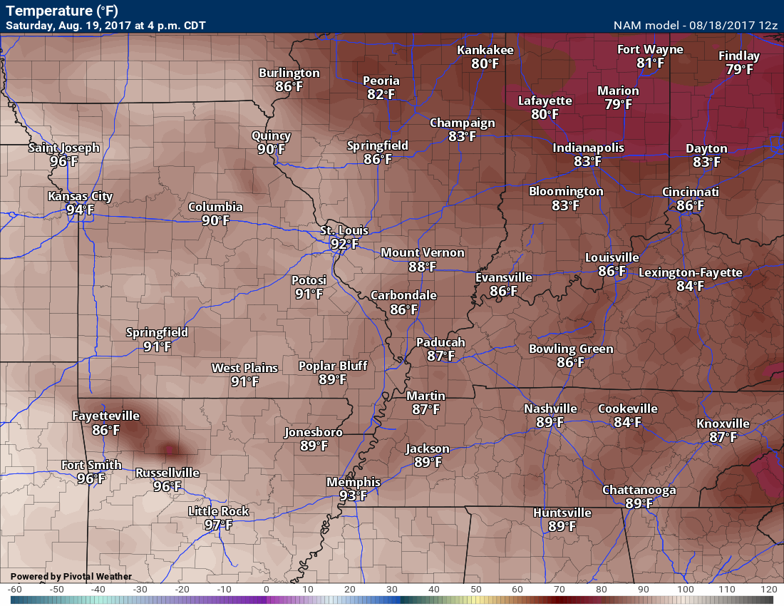
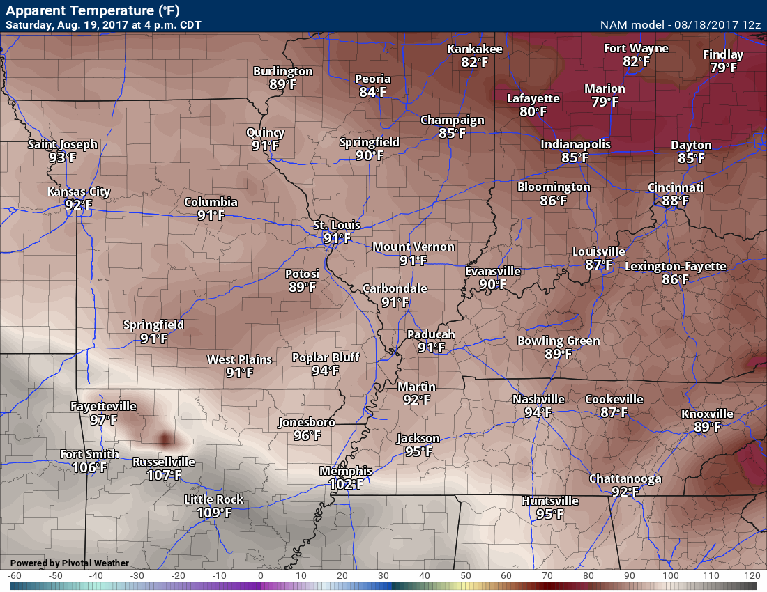
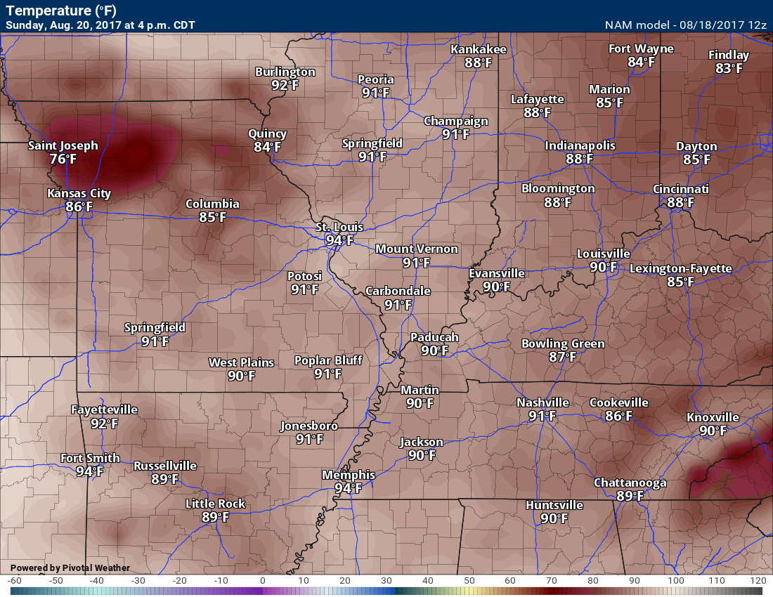
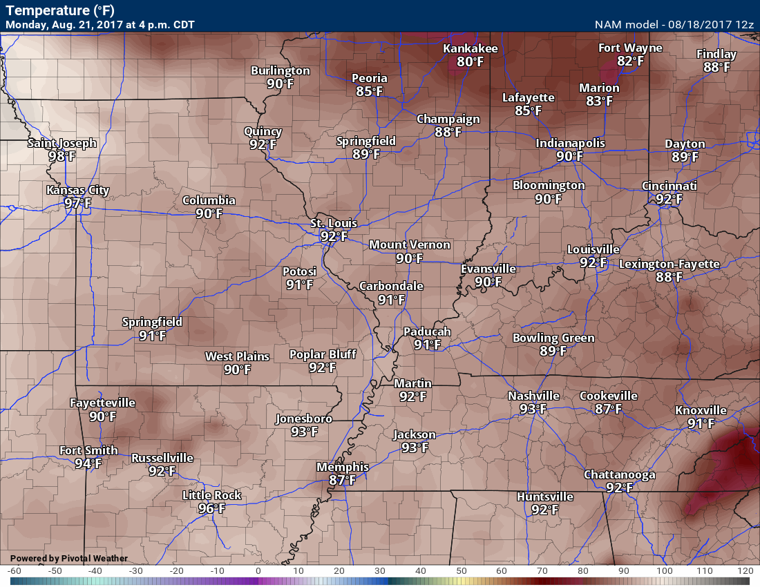
The weekend is upon us and it is going to be warm. You can expect highs in the upper 80’s on Saturday, Sunday, and Monday. It is possible we reach the lower 90’s on Sunday and Monday. Keep that in mind.
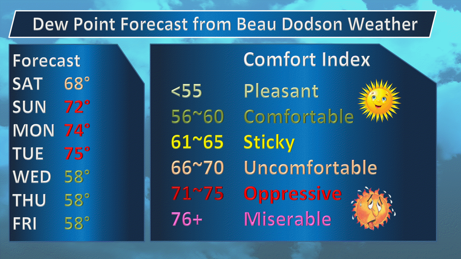
Muggy, as well. Click the dew point map to enlarge.
August has been kind to us. Yes, it has been warm the last few days, but let’s take a look at the whole month.
Each day marked in yellow was a below normal temperature day. Most of the month has been below normal. This semi-makes up for July!
Click images for a larger view.
Unfortunately, it has also been dry.
The latest short term dryness charts are showing it well.
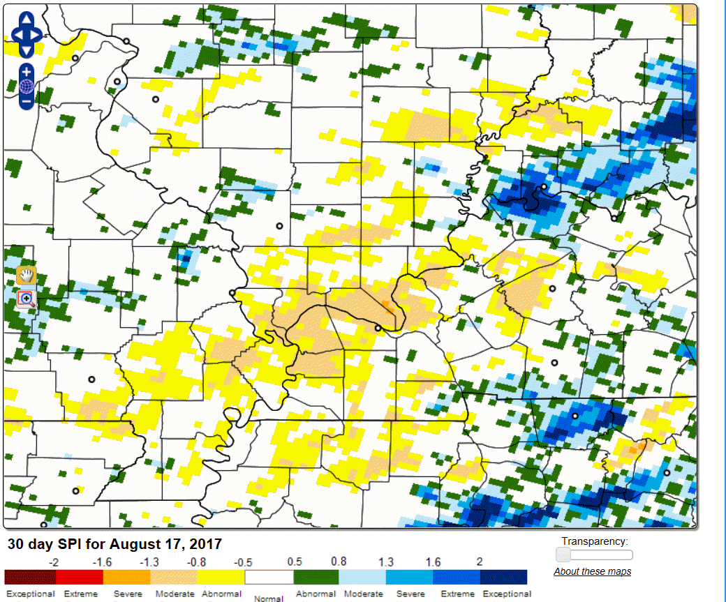
Extreme southern Illinois is quite dry. Luck of the draw, because some areas have received rain.
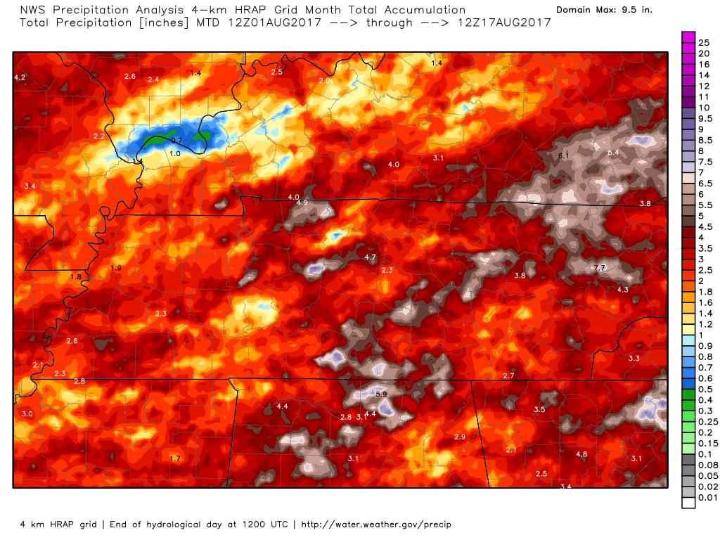
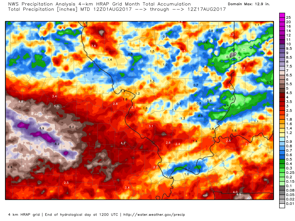
Let me show you month to date rainfall totals. I know it is difficult to find your location on this map. Look for the state lines.
Notice extreme southern Illinois has missed out on most of the rain since August 1st.
Southern Illinois is the top left part of this graphic.
Click to enlarge. Extreme southern Illinois in blue. Very little rainfall.
Here is a northern view of the month to date rainfall
Click images to enlarge
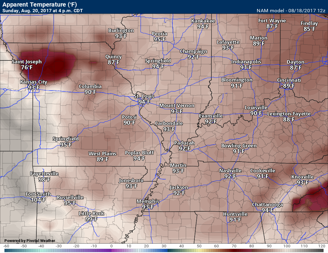
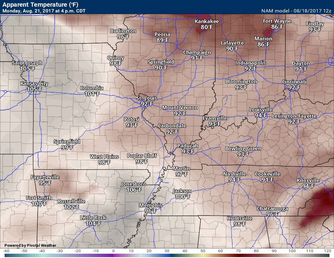
Dew points will be quite high. It will likely feel humid/muggy (most of the time).
Heat index values above 90 degrees are likely all three days.
Saturday afternoon temperatures
Saturday heat index values
Sunday afternoon temperatures
Sunday afternoon heat index values
Monday afternoon temperatures
Monday afternoon heat index
Precipitation forecast
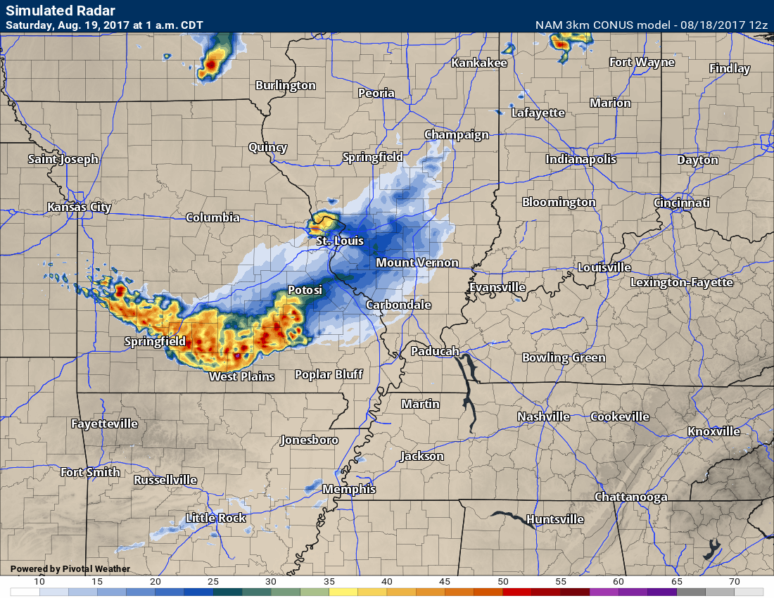
A weak cold front will sink into the region late Friday night and Saturday morning. A band of showers and thunderstorms may accompany the front. Many areas will remain dry, but a few locations may pick up a quick 0.10″ to 0.30″.
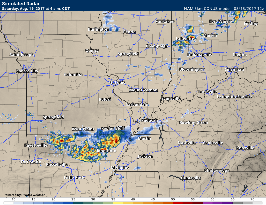
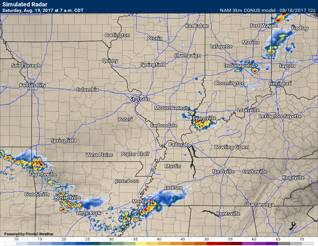
Here is the NAM future-cast radar guidance. The NAM guidance does show a band of precipitation pushing southward through the area late tonight.
1 AM future-cast radar for Saturday
4 AM future-cast radar for Saturday
7 AM Saturday future-cast radar
10 AM future-cast radar for Saturday.
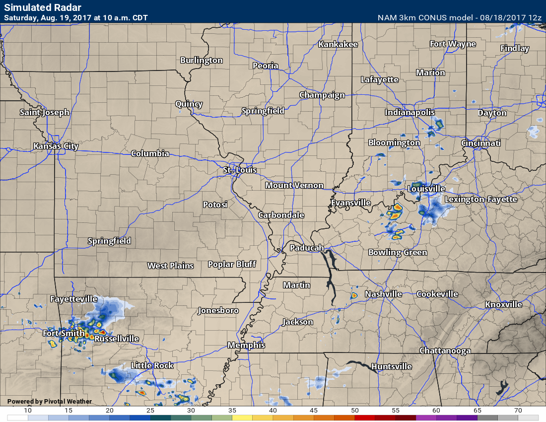
Isolated storms possible on Saturday
Sunday
The GFS shows mostly cloudy sky conditions on Sunday. Isolated showers and thunderstorms. Not sure GFS is on to something with the amount of clouds. NAM has less clouds. Plan on a mix of sun and clouds. Temperatures in the upper 80’s to lower 90’s. Dew points in the upper 60’s to lower 70’s.
Monday (eclipse)
I continue to paint some clouds in the area on Monday. I have been saying 30% to 40%. It is a complicated forecast. If we don’t have cirrus in the morning (high clouds) and we heat up too fast, then cumulus clouds will develop. On the other hand, if we have some clouds in the morning, then that would slow down heating. That would mean less cumulus clouds.
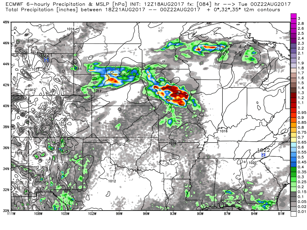
EC rainfall for late in the day Monday. Notice some scattered totals just to our west. These are rain totals from 1 pm to 7 pm. Light totals brushed over portions of Missouri and perhaps southwest Illinois. We will need to monitor the bigger storm complex over Iowa and northern Missouri.
The forecast is for a mix of sun and clouds. We will hope for the best. I continue with a 20% for showers and thunderstorms.
Highs will likely rise into the 85 to 88 degree range before total eclipse. Some lower 90’s can’t be ruled out. This will depend on sunshine.
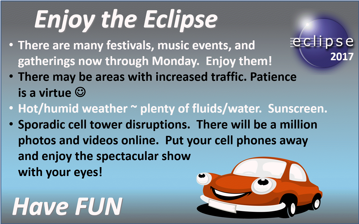
It is going to be a busy weekend (travel wise). Let’s all be patient with the new people in town! Cell phone towers also will likely have trouble. Too many people on them at once.
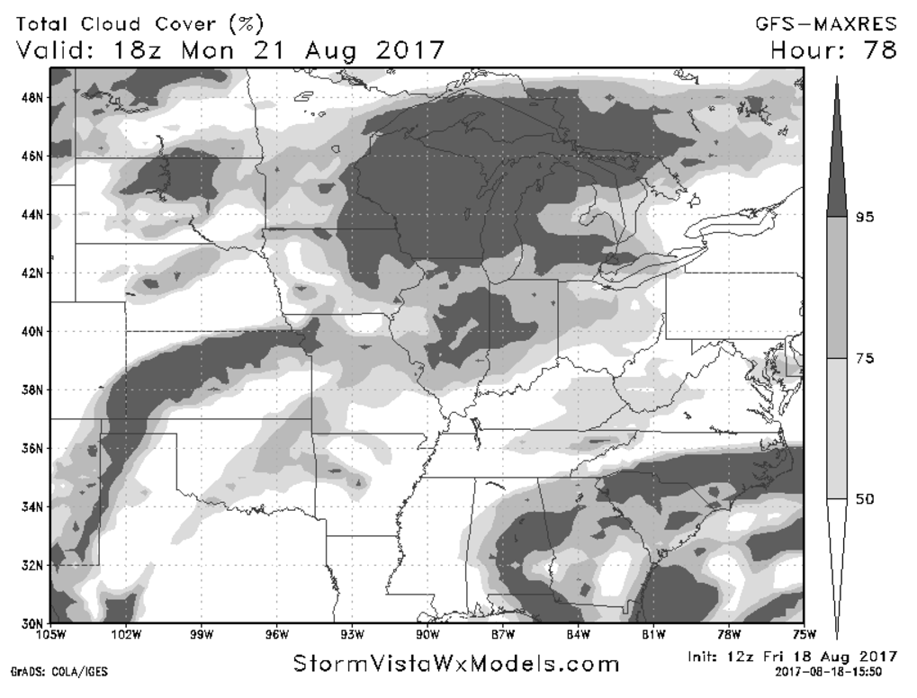
GFS cloud cover for Monday
GFS shows most of the clouds over our northern counties with plenty of sun locally.
Eclipse weekend is here!
Are you subscribing to the Weather Talk texts and videos?
We now have premiere videos for the short and long range forecasts! Make sure you have text option four turned on (green).
Sign up at www.beaudodsonweather.com
We also have an Apple and Android app (scroll down to bottom of the page for more information)

Were you aware that I have hired some help for long range videos? Short range videos, as well. An amazing team of meteorologists.
Click the link below to read more
http://cms.weathertalk.com/meet-the-team/
Weather Talk subscribers now have some of the best short and long range weather videos produced across the eastern United States.
.

Find me on Twitter
.

We have regional radars and local city radars – if a radar does not update then try another one. Occasional browsers need their cache cleared. You may also try restarting your browser. That usually fixes the problem. Occasionally we do have a radar go down. That is why I have duplicates. Thus, if one fails then try another one.
During the winter you can track snow and ice by clicking the winterize button on the local city view interactive radars.
If you have any problems then please send me an email beaudodson@usawx.com
Interactive Weather Radar Page. Choose the city nearest your location: Click this link—
National interactive radar: Click this link.
Local interactive city radars include St Louis, Mt Vernon, Evansville, Poplar Bluff, Cape Girardeau, Marion, Paducah, Hopkinsville, Memphis, Nashville, Dyersburg, and all of eastern Kentucky. These are interactive radars. Local city radars – click here
The Beau Dodson Weather APP is ready for Apple and Android users. The purpose of this app is for me to deliver your text messages instantly. ATT and Verizon have not always been reliable when it comes to speed. The app allows instant delivery.
Some of you have asked if you can keep receiving the texts on your phone and the app. The answer to that is, yes. The Android app will automatically allow that to happen. On the Apple app, however, you will need to go into your app and click settings. Make sure the green tab is OFF. Off means you will still receive the texts to your phone and the app. If you have any questions, then email me at beaudodson@usawx.com
The app is for text subscribers.
The direct download, for the Apple app, can be viewed here
https://itunes.apple.com/us/app/id1190136514
If you have not signed up for the texting service then you may do so at www.beaudodsonweather.com

The Android app is also ready.
Remember, the app’s are for www.weathertalk.com subscribers. The app allows your to receive the text messages faster than ATT and Verizon.
Here is the download link for the Android version Click Here

——————————————————–
If you have not signed up for the texts messages, then please do. Link www.beaudodsonweather.com
Your support helps with the following:

and


Who do you trust for your weather information and who holds them accountable?
I have studied weather in our region since the late 1970’s. I have 39 years of experience in observing our regions weather patterns. My degree is in Broadcast Meteorology and a Bachelor’s of Science.
My resume includes:
Member of the American Meteorological Society.
NOAA Weather-Ready Nation Ambassador.
Meteorologist for McCracken County Emergency Management. I served from 2005 through 2015.
Meteorologist for McCracken County Rescue. 2015 through current
I own and operate the Southern Illinois Weather Observatory.
I am the chief meteorologist for Weather Talk LLC. I am the owner of Weather Talk LLC.
I am also a business owner in western Kentucky.
Recipient of the Mark Trail Award, WPSD Six Who Make A Difference Award, Kentucky Colonel, and the Caesar J. Fiamma” Award from the American Red Cross.
In 2005 I helped open the largest American Cross shelter in U.S. history in Houston, Texas. I was deployed to help after Hurricane Katrina and Hurricane Rita. I was a shelter manager of one of the Houston, Texas shelter divisions.
In 2009 I was presented with the Kentucky Office of Highway Safety Award.
Recognized by the Kentucky House of Representatives for my service to the State of Kentucky leading up to several winter storms and severe weather outbreaks.
If you click on the image below you can read the Kentucky House of Representatives Resolution.

I am also President of the Shadow Angel Foundation which serves portions of western Kentucky and southern Illinois.
There is a lot of noise on the internet. A lot of weather maps are posted without explanation. Over time you should learn who to trust for your weather information.
My forecast philosophy is simple and straight forward.
- Communicate in simple terms
- To be as accurate as possible within a reasonable time frame before an event
- Interact with you on Twitter, Facebook, email, texts, and this blog
- Minimize the “hype” that you might see on some television stations or through other weather sources
- Push you towards utilizing wall-to-wall LOCAL TV coverage during severe weather events
Many of the graphics on this page are from www.weatherbell.com
WeatherBell is a great resource for weather model guidance.


You can sign up for my AWARE email by clicking here I typically send out AWARE emails before severe weather, winter storms, or other active weather situations. I do not email watches or warnings. The emails are a basic “heads up” concerning incoming weather conditions