


Videos can be viewed at this link. Long Range Video Update
If you believe you missed a video then you can also click the LIVE FEED link on the Weather Talk website. That page holds links for several days.
I can text you the videos, as well. Make sure you have text option FOUR turned on. That would be the Weather Extra text option. Sign up for the text messages at www.beaudodsonweather.com
.

.
This forecast update covers southern Illinois, southeast Missouri, western Kentucky. and northwest Tennessee.
.
The following link is for Weather Text subscribers. This is the page where short and long range video outlooks have been posted. The videos are being produced by a team of meteorologists. Some of the best in the region.
https://weathertalk.com/app/beaucast
.
August 15, 2017
Tuesday Night Forecast Details:
Forecast: Partly cloudy. A chance for showers and thunderstorms. There might be an uptick in activity late tonight into the early morning hours. Patchy fog possible.
Temperatures: MO ~ 70 to 74 IL ~ 70 to 74 KY ~ 70 to 74 TN ~ 70 to 74
Winds: South winds at 5 to 10 mph
What impacts are anticipated from the weather? A few wet roadways and lightning.
My confidence in the forecast verifying: Medium. Some adjustments are possible.
Is severe weather expected? Unlikely
The NWS defines severe weather as 58 mph winds or great, 1″ hail or larger, and/or tornadoes
What is the chance of precipitation? MO ~ 40% (a bit higher for the Bootheel) IL ~ 40% KY ~ 40% TN ~ 40%
Coverage of precipitation: Perhaps scattered.
Should I cancel my outdoor plans. No, but check radars.
.
August 16, 2017
Wednesday Forecast Details
Forecast: Partly sunny. Scattered thunderstorms possible. Hot. Humid/muggy.
Temperatures: MO ~ 86 to 90 IL ~ 86 to 90 KY ~ 86 to 90 TN ~ 86 to 90
Winds: South and southwest at 5 to 10 mph
What impacts are anticipated from the weather? Scattered wet roadways and lightning.
My confidence in the forecast verifying: Medium. Some adjustments are possible.
Is severe weather expected? Unlikely, but monitor updates
The NWS defines severe weather as 58 mph winds or great, 1″ hail or larger, and/or tornadoes
What is the chance of precipitation? MO ~ 40% IL ~ 40% KY ~ 40% TN ~ 40%
Coverage of precipitation: Scattered
Should I cancel my outdoor plans? No, but check radars
.
Wednesday Night Forecast Details:
Forecast: Partly cloudy. Gusty winds. Isolated to scattered thunderstorms. Warm and humid.
Temperatures: MO ~ 74 to 78 IL ~ 74 to 78 KY ~ 74 to 78 TN ~ 74 to 78
Winds: South and southwest at 10 to 20 mph. Gusty winds possible Wednesday night.
What impacts are anticipated from the weather? Scattered wet roadways and lightning.
My confidence in the forecast verifying: Medium. Some adjustments are possible.
Is severe weather expected? Unlikely, but monitor updates.
The NWS defines severe weather as 58 mph winds or great, 1″ hail or larger, and/or tornadoes
What is the chance of precipitation? MO ~ 30% IL ~ 30% KY ~ 30% TN ~ 30%
Coverage of precipitation: Isolated to scattered
Should I cancel my outdoor plans? No, but check radars
.
August 17, 2017
Thursday Forecast Details
Forecast: Quite a few clouds. Warm. Muggy. A few scattered thunderstorms. Some areas may remain dry.
Temperatures: MO ~ 86 to 90 IL ~ 86 to 90 KY ~ 86 to 90 TN ~ 86 to 90
Winds: South and southwest at 10 to 20 mph. Gusty, at times.
What impacts are anticipated from the weather? Wet roadways. Lightning.
My confidence in the forecast verifying: Medium. Some adjustments are possible.
Is severe weather expected? Some storms could produce strong winds
The NWS defines severe weather as 58 mph winds or great, 1″ hail or larger, and/or tornadoes
What is the chance of precipitation? MO ~ ~ 40% IL ~ 40% KY ~ 40% TN ~ 40%
Coverage of precipitation: Scattered
Should I cancel my outdoor plans? Check radars and plan on some rain in the region. Have a plan B.
.
Thursday Night Forecast Details:
Forecast: Quite a few clouds. Showers and thunderstorms ending.
Temperatures: MO ~ 63 to 68 IL ~ 63 to 68 KY ~ 63 to 68 TN ~ 63 to 68
Winds: South and southwest at 6 to 12 mph. Winds becoming west and northwest overnight at speeds of 5 to 10 mph
What impacts are anticipated from the weather? Wet roadways. Lightning.
My confidence in the forecast verifying: Medium. Some adjustments are possible.
Is severe weather expected? Monitor updates
The NWS defines severe weather as 58 mph winds or great, 1″ hail or larger, and/or tornadoes
What is the chance of precipitation? MO ~ 30% IL ~ 30% KY ~ 30% TN ~ 30%
Coverage of precipitation: Scattered early, but ending as the night wears on.
Should I cancel my outdoor plans? No, but check radars.
.
August 18, 2017
Friday Forecast Details
Forecast: Partly to mostly sunny.
Temperatures: MO ~ 85 to 88 IL ~ 85 to 88 KY ~ 85 to 88 TN ~ 85 to 88
Winds: West and northwest at 6 to 12 mph
What impacts are anticipated from the weather? None to perhaps isolated wet roadways and lightning early in the day
My confidence in the forecast verifying: Medium. Some adjustments are possible.
Is severe weather expected? No
The NWS defines severe weather as 58 mph winds or great, 1″ hail or larger, and/or tornadoes
What is the chance of precipitation? MO ~ 10% IL ~ 10% KY ~ 10% TN ~ 10%
Coverage of precipitation: None to isolated.
Should I cancel my outdoor plans? No
.
Friday Night Forecast Details:
Forecast: Some clouds. Partly cloudy. A slight chance for storms after 2 am. Patchy fog possible.
Temperatures: MO ~ 64 to 68 IL ~ 64 to 68 KY ~ 64 to 68 TN ~ 64 to 68
Winds: Variable winds to southwest winds at 5 to 10 mph
What impacts are anticipated from the weather? Most likely none. Some fog can’t be ruled out.
My confidence in the forecast verifying: Medium. Some adjustments are possible
Is severe weather expected? No
The NWS defines severe weather as 58 mph winds or great, 1″ hail or larger, and/or tornadoes
What is the chance of precipitation? MO ~ 20% IL ~ 20% KY ~ 20% TN ~ 10%
Coverage of precipitation: None for most of the night. Perhaps scattered after 2 am.
Should I cancel my outdoor plans? No
.
August 19, 2017
Saturday Forecast Details
Forecast: Partly sunny. Scattered showers and thunderstorms possible.
Temperatures: MO ~ 84 to 88 IL ~ 84 to 88 KY ~ 84 to 88 TN ~ 84 to 88
Winds: Variable at 4 to 8 mph
What impacts are anticipated from the weather? Scattered wet roads and lightning.
My confidence in the forecast verifying: Medium. Some adjustments are possible.
Is severe weather expected? No
The NWS defines severe weather as 58 mph winds or great, 1″ hail or larger, and/or tornadoes
What is the chance of precipitation? MO ~ 30% IL ~ 30% KY ~ 30% TN ~ 30%
Coverage of precipitation: Isolated to scattered
Should I cancel my outdoor plans? No, but check radars
.
Saturday Night Forecast Details:
Forecast: Partly cloudy. An evening shower or thunderstorm possible. Patchy fog possible.
Temperatures: MO ~ 65 to 70 IL ~ 65 to 70 KY ~ 65 to 70 TN ~ 65 to 70
Winds: Variable at 4 to 8 mph
What impacts are anticipated from the weather? Wet roadways and lightning.
My confidence in the forecast verifying: Medium. Some adjustments are possible.
Is severe weather expected? No
The NWS defines severe weather as 58 mph winds or great, 1″ hail or larger, and/or tornadoes
What is the chance of precipitation? MO ~ 20% IL ~ 30% KY ~ 30% TN ~ 20%
Coverage of precipitation: Isolated early
Should I cancel my outdoor plans? No, but check radars
.
August 20, 2017
Sunday Forecast Details
Forecast: Mostly sunny and mild. An isolated thunderstorm possible.
Temperatures: MO ~ 84 to 88 IL ~ 84 to 88 KY ~ 84 to 88 TN ~ 84 to 88
Winds: Variable at 4 to 8 mph. Winds mostly southeast and south.
What impacts are anticipated from the weather? Isolated wet roadways and lightning.
My confidence in the forecast verifying: Medium. Some adjustments are possible
Is severe weather expected? No
The NWS defines severe weather as 58 mph winds or great, 1″ hail or larger, and/or tornadoes
What is the chance of precipitation? MO ~ 20% IL ~ 20% KY ~ 20% TN ~ 20%
Coverage of precipitation: None to isolated.
Should I cancel my outdoor plans? No
.
Sunday Night Forecast Details:
Forecast: Mostly clear. Mild. Fog possible. A slight chance for a thunderstorm.
Temperatures: MO ~ 65 to 70 IL ~ 65 to 70 KY ~ 65 to 70 TN ~ 65 to 70
Winds: Light and variable <10 mph.
What impacts are anticipated from the weather? Most likely none.
My confidence in the forecast verifying: Medium. Some adjustments are possible
Is severe weather expected? No
The NWS defines severe weather as 58 mph winds or great, 1″ hail or larger, and/or tornadoes
What is the chance of precipitation? MO ~ 10% IL ~ 10% KY ~ 10% TN ~ 10%
Coverage of precipitation: None to isolated.
Should I cancel my outdoor plans? No
.
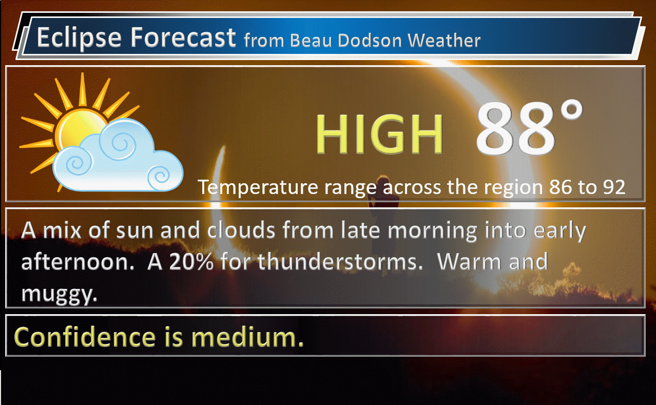
August 21, 2017
Eclipse Day
Monday Forecast Details
Forecast: Partly cloudy. Isolated thunderstorms possible. Hot. Humid. Cirrus clouds possible. Not sure on how much coverage.
Temperatures: MO ~ 86 to 92 IL ~ 86 to 92 KY ~ 86 to 92 TN ~ 86 to 92
Winds: South and southwest at 5 to 10 mph
What impacts are anticipated from the weather? Perhaps isolated wet roadways and lightning.
My confidence in the forecast verifying: Medium. Some adjustments are possible
Is severe weather expected? Not at this time
The NWS defines severe weather as 58 mph winds or great, 1″ hail or larger, and/or tornadoes
What is the chance of precipitation? MO ~ 20% IL ~ 20% KY ~ 20% TN ~ 20%
Coverage of precipitation: Isolated
Should I cancel my outdoor plans? No, but check radars and updated forecast numbers.
.
Monday Night Forecast Details:
Forecast: Partly cloudy. A slight chance for an evening thunderstorm.
Temperatures: MO ~ 68 to 74 IL ~ 68 to 74 KY ~ 68 to 74 TN ~ 68 to 74
Winds: South and southwest at 4 to 8 mph
What impacts are anticipated from the weather? Most likely none. Isolated wet roadways and lightning.
My confidence in the forecast verifying: Low. Significant adjustments possible.
Is severe weather expected? Not at this time
The NWS defines severe weather as 58 mph winds or great, 1″ hail or larger, and/or tornadoes
What is the chance of precipitation? MO ~ 20% IL ~ 20% KY ~ 20% TN ~ 20%
Coverage of precipitation: Isolated
Should I cancel my outdoor plans? No
.
August 22, 2017
Tuesday Forecast Details
Forecast: Partly cloudy. Isolated thunderstorms possible. Hot. Humid. Cirrus clouds possible. Not sure on how much coverage.
Temperatures: MO ~ 86 to 90 IL ~ 86 to 90 KY ~ 86 to 90 TN ~ 86 to 90
Winds: South and southwest at 5 to 10 mph
What impacts are anticipated from the weather? Perhaps isolated wet roadways and lightning.
My confidence in the forecast verifying: Low. Significant adjustments are possible
Is severe weather expected? Not at this time
The NWS defines severe weather as 58 mph winds or great, 1″ hail or larger, and/or tornadoes
What is the chance of precipitation? MO ~ 20% IL ~ 20% KY ~ 20% TN ~ 20%
Coverage of precipitation: Isolated
Should I cancel my outdoor plans? No, but check radars and updated forecast numbers.
.
Tuesday Night Forecast Details:
Forecast: Partly cloudy. A slight chance for an evening thunderstorm.
Temperatures: MO ~ 68 to 74 IL ~ 68 to 74 KY ~ 68 to 74 TN ~ 68 to 74
Winds: South and southwest at 4 to 8 mph
What impacts are anticipated from the weather? Most likely none. Isolated wet roadways and lightning.
My confidence in the forecast verifying: Low. Significant adjustments possible.
Is severe weather expected? Not at this time
The NWS defines severe weather as 58 mph winds or great, 1″ hail or larger, and/or tornadoes
What is the chance of precipitation? MO ~ 20% IL ~ 20% KY ~ 20% TN ~ 20%
Coverage of precipitation: Isolated
Should I cancel my outdoor plans? No
.

Don’t forget to check out the Southern Illinois Weather Observatory web-site for weather maps, tower cams, scanner feeds, radars, and much more! Click here

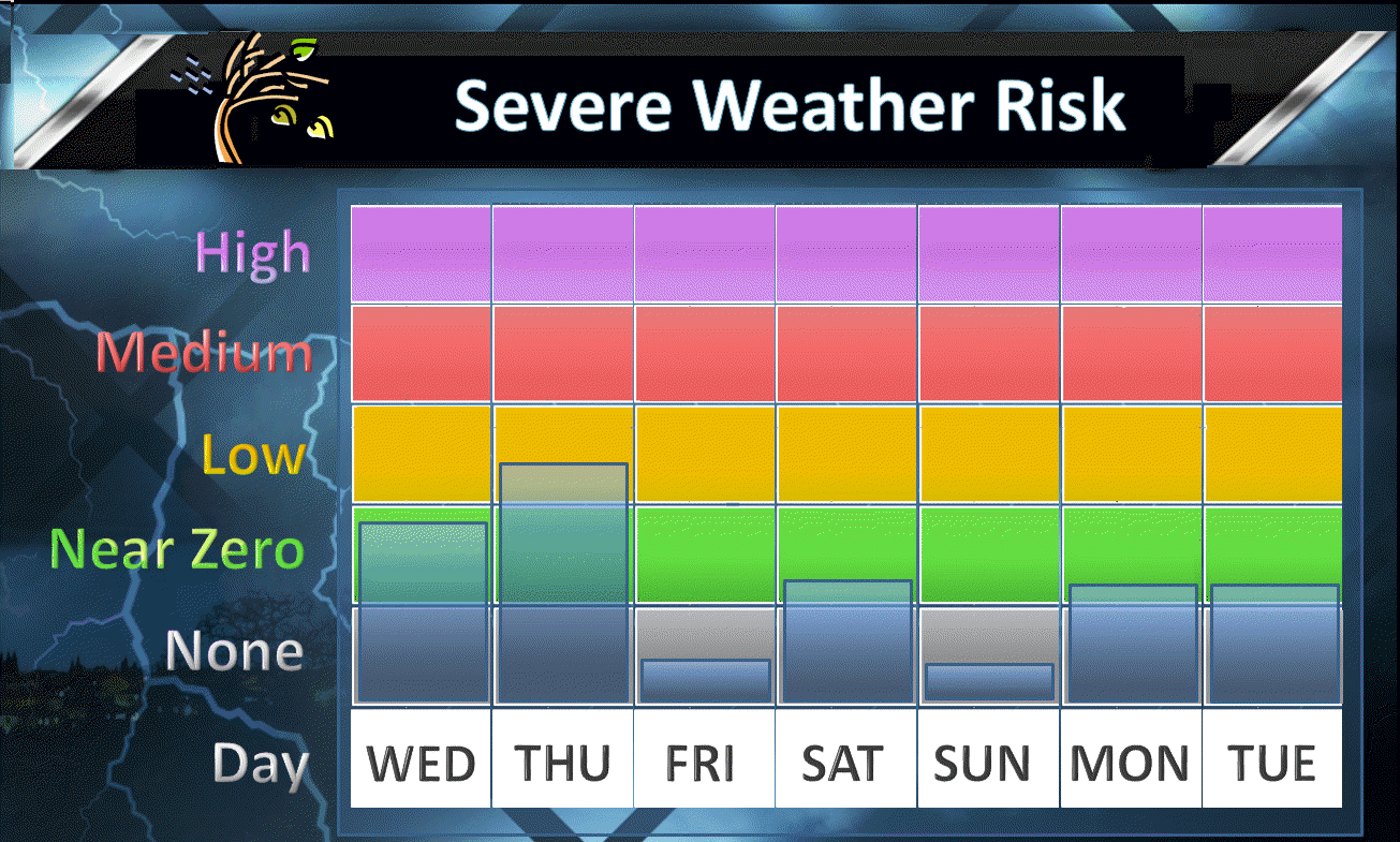
A severe thunderstorm is defined as a storm that produces quarter size hail or larger, 58 mph winds or greater, and/or a tornado. That is the official National Weather Service definition of a severe thunderstorm.
Tuesday night through Thursday: Thunderstorms are possible, but most likely will remain below severe levels. Gusty winds and lightning will be possible.
The best chance for stronger storms would be on Thursday. That would occur along an incoming cold front.

Hot and muggy conditions over the next 48 hours. It will feel like summer. We had a nice run of below normal temperatures and to be fair the coming days won’t actually bring temperatures more than a degree or two above average.
Generally near normal to slightly above normal temperatures through Thursday.
Wednesday high temperatures
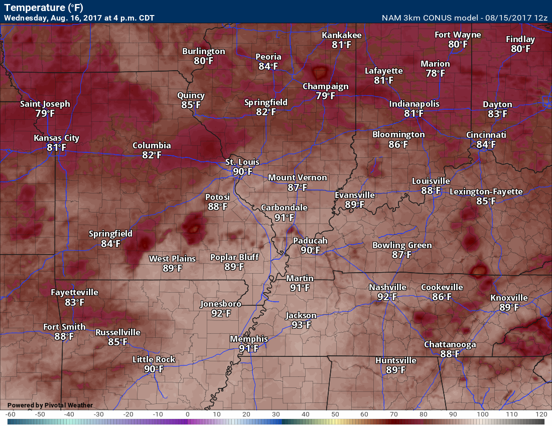
Temperatures will vary greatly based on clouds and rain
Wednesday heat index map
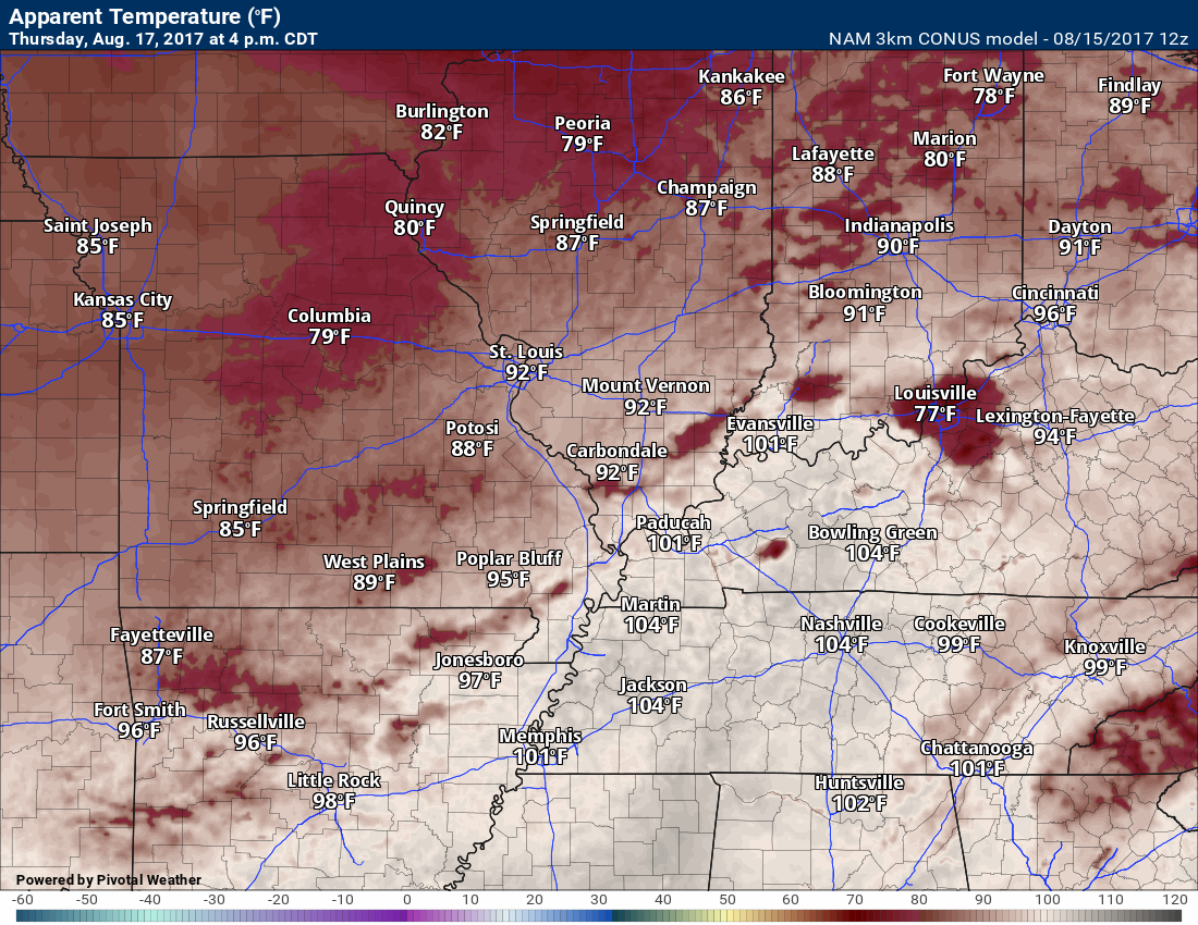
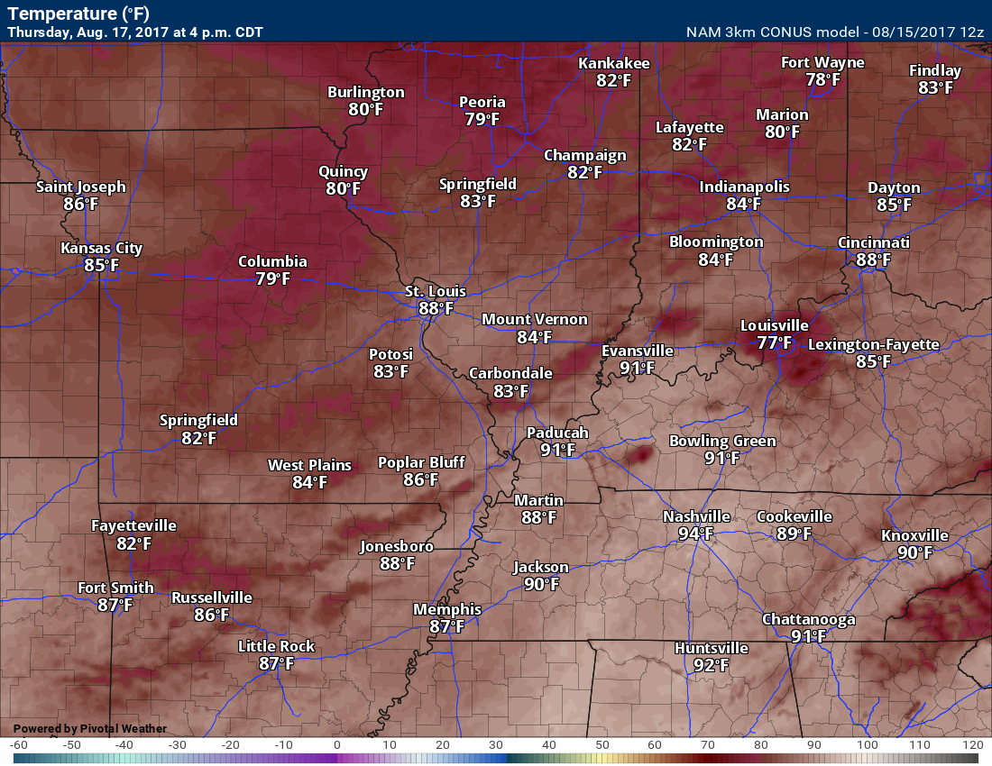
Thursday high temperatures
Temperatures will vary greatly based on clouds and rain
Thursday heat index map
Normal high temperatures are in the upper 80’s. You can expect both Wednesday and Thursday to deliver 85 to 88 degree readings. Isolated higher numbers. Dew points will be high. That means heat index values above 95 degrees on both Wednesday and Thursday, as well.
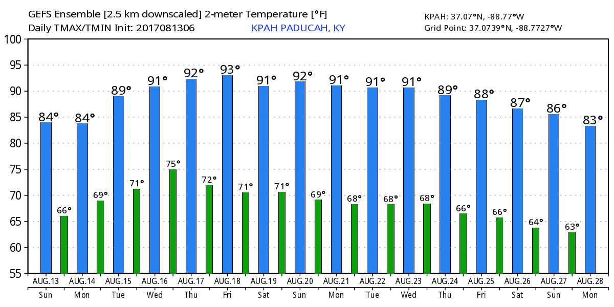
Here is the long range temperature outlook from the GEFS ensembles. Nothing too extreme, but several hot days embedded in the outlook.
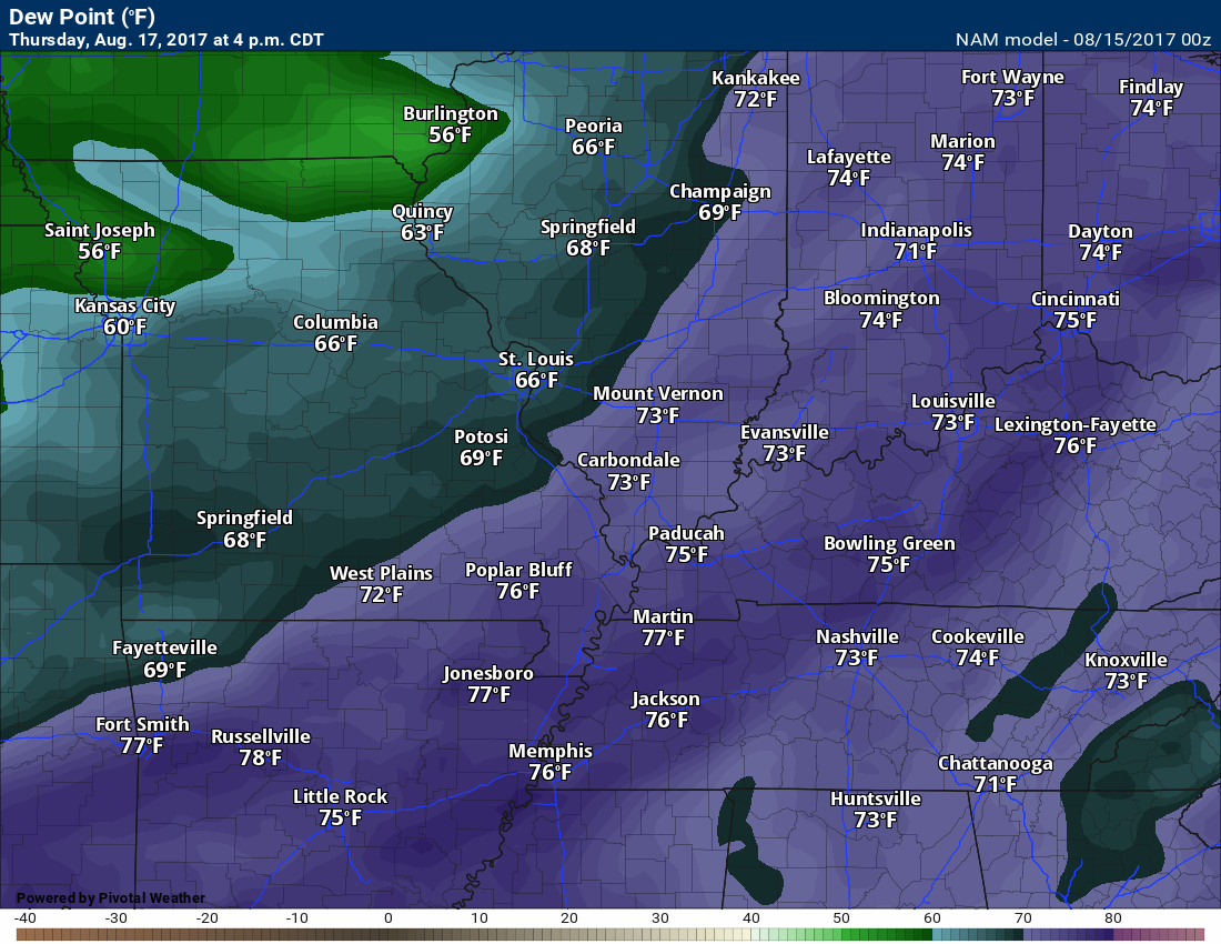
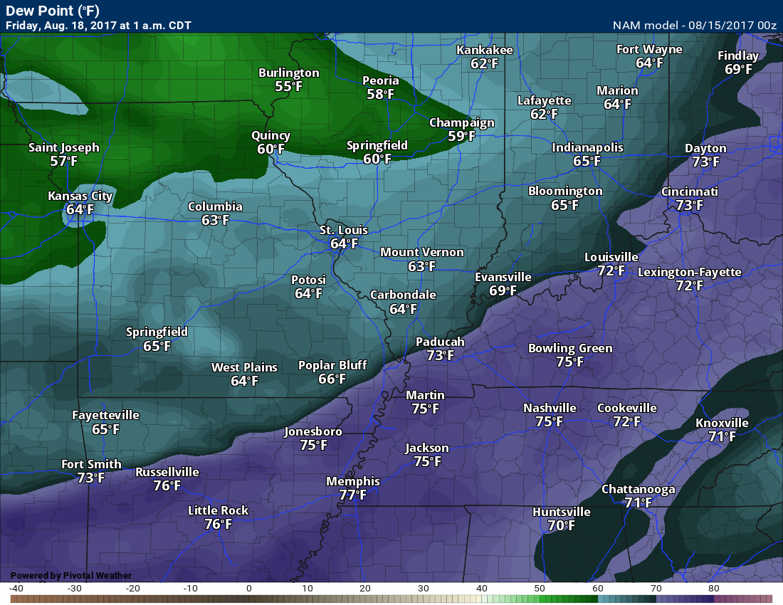
A cold front will be moving into the region late Thursday into Thursday evening. This front will be the focus for additional shower and thunderstorm chances. A few strong storms are possible, but organized severe weather appears unlikely. Typically, August is a slow month for severe weather in our region.
You can see the frontal passage on the NAM model dew point map. High dew points pool ahead of the front. Lower dew points behind the front.
Thursday dew points at 4 pm. See the drop off behind the front?
Friday 1 am dew point map
Rainfall totals from now through Thursday evening will range from less than 0.25″ to over an inch. As always, thunderstorms can produce heavier totals.
Some areas may completely miss out on the rain, again. Same song and dance from recent weeks. Typical for summer.
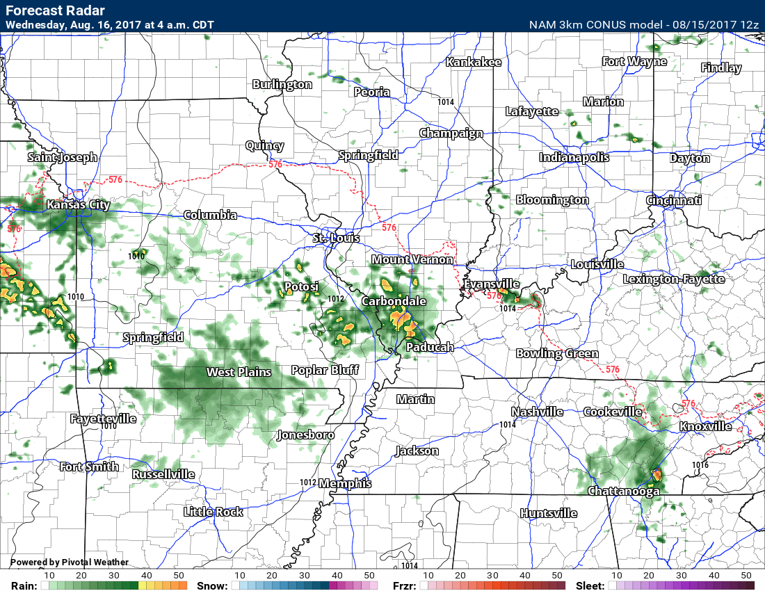
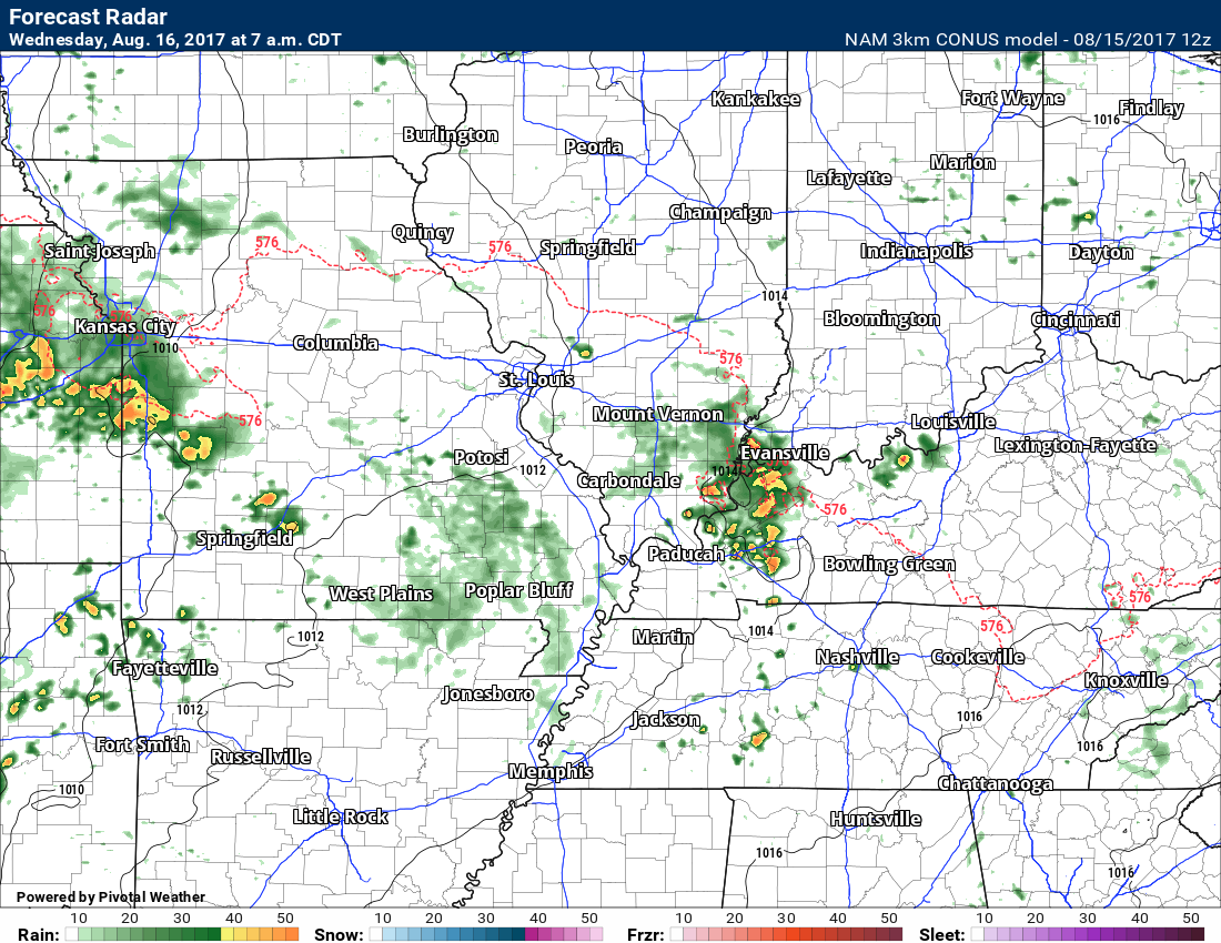
Here is the NAM high resolution guidance future-cast radar. Keep in mind, models handle thunderstorms poorly.
4 AM, Wednesday, August 16th
NAM believes there will be showers and thunderstorms in the region later tonight into the wee morning hours of Wednesday.
and then 7 AM, Wednesday morning
We will see if this actually occurs. Models handle our current pattern poorly when it comes to precipitation.
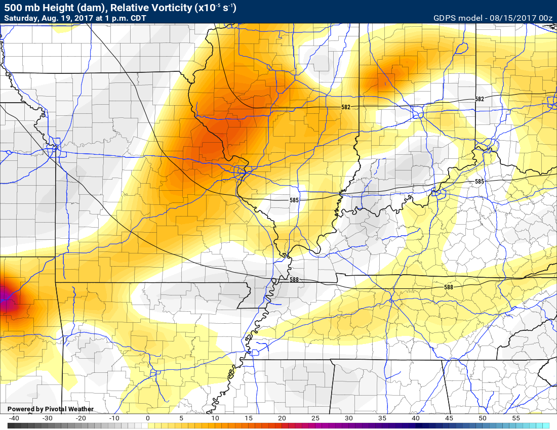
Another system will pass through our region on Saturday. It appears a few showers and thunderstorms are possible. The greatest chance for rain may remain a bit to our north, but the system is far enough south to warrant at least a chance for precipitation.
The Canadian model guidance shows the 500 mb vorticity. The highest values are too our north. Rain probabilities will be higher over central Illinois. Lesser chances into our region, but at least scattered showers/storms possible.
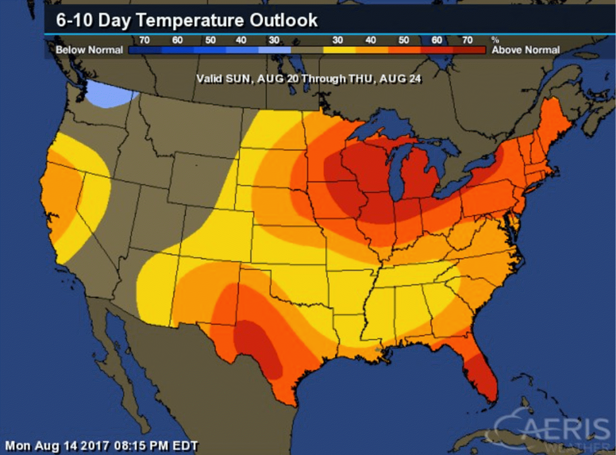
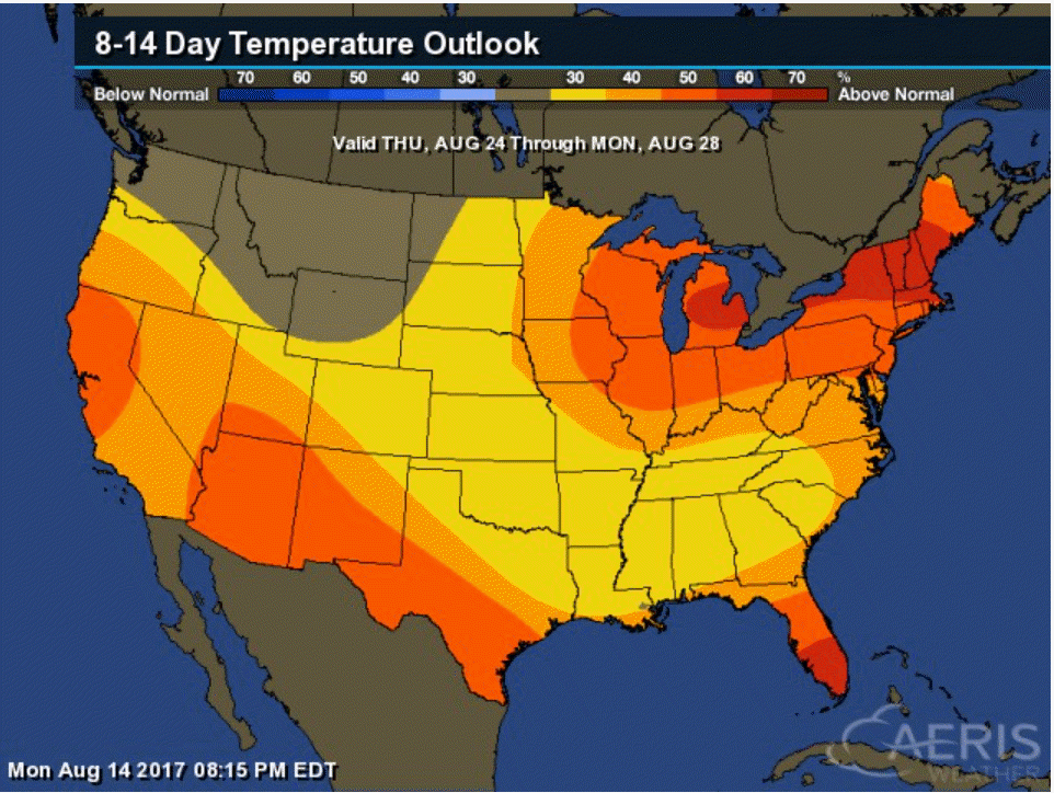
The latest 6 to 10 and 8 to 14 day temperature outlooks are leaning warmer than normal. A 30% to 40% chance for normal to above normal readings.
Sunday, August 20th through Thursday, August 24th
Click images to enlarge
Then Thursday, August 24th through Monday, August 28th
I continue to monitor the potential for clouds on August 21st. For now, I have kept the forecast as partly cloudy, warm, and humid. A slight chance for a thunderstorm. Cumulus clouds are possible.
Cirrus clouds from dying thunderstorms will also be possible. Thick Cirrus clouds would ruin the eclipse.
For now, it does not look like widespread rain will occur on Monday.
Are you subscribing to the Weather Talk texts and videos?
We now have premiere videos for the short and long range forecasts! Make sure you have text option four turned on (green).
Sign up at www.beaudodsonweather.com
We also have an Apple and Android app (scroll down to bottom of the page for more information)

Were you aware that I have hired some help for long range videos? Short range videos, as well. An amazing team of meteorologists.
Click the link below to read more
http://cms.weathertalk.com/meet-the-team/
Weather Talk subscribers now have some of the best short and long range weather videos produced across the eastern United States.
.

Find me on Twitter
.

We have regional radars and local city radars – if a radar does not update then try another one. Occasional browsers need their cache cleared. You may also try restarting your browser. That usually fixes the problem. Occasionally we do have a radar go down. That is why I have duplicates. Thus, if one fails then try another one.
During the winter you can track snow and ice by clicking the winterize button on the local city view interactive radars.
If you have any problems then please send me an email beaudodson@usawx.com
Interactive Weather Radar Page. Choose the city nearest your location: Click this link—
National interactive radar: Click this link.
Local interactive city radars include St Louis, Mt Vernon, Evansville, Poplar Bluff, Cape Girardeau, Marion, Paducah, Hopkinsville, Memphis, Nashville, Dyersburg, and all of eastern Kentucky. These are interactive radars. Local city radars – click here
The Beau Dodson Weather APP is ready for Apple and Android users. The purpose of this app is for me to deliver your text messages instantly. ATT and Verizon have not always been reliable when it comes to speed. The app allows instant delivery.
Some of you have asked if you can keep receiving the texts on your phone and the app. The answer to that is, yes. The Android app will automatically allow that to happen. On the Apple app, however, you will need to go into your app and click settings. Make sure the green tab is OFF. Off means you will still receive the texts to your phone and the app. If you have any questions, then email me at beaudodson@usawx.com
The app is for text subscribers.
The direct download, for the Apple app, can be viewed here
https://itunes.apple.com/us/app/id1190136514
If you have not signed up for the texting service then you may do so at www.beaudodsonweather.com

The Android app is also ready.
Remember, the app’s are for www.weathertalk.com subscribers. The app allows your to receive the text messages faster than ATT and Verizon.
Here is the download link for the Android version Click Here

——————————————————–
If you have not signed up for the texts messages, then please do. Link www.beaudodsonweather.com
Your support helps with the following:

and


Who do you trust for your weather information and who holds them accountable?
I have studied weather in our region since the late 1970’s. I have 39 years of experience in observing our regions weather patterns. My degree is in Broadcast Meteorology and a Bachelor’s of Science.
My resume includes:
Member of the American Meteorological Society.
NOAA Weather-Ready Nation Ambassador.
Meteorologist for McCracken County Emergency Management. I served from 2005 through 2015.
Meteorologist for McCracken County Rescue. 2015 through current
I own and operate the Southern Illinois Weather Observatory.
I am the chief meteorologist for Weather Talk LLC. I am the owner of Weather Talk LLC.
I am also a business owner in western Kentucky.
Recipient of the Mark Trail Award, WPSD Six Who Make A Difference Award, Kentucky Colonel, and the Caesar J. Fiamma” Award from the American Red Cross.
In 2005 I helped open the largest American Cross shelter in U.S. history in Houston, Texas. I was deployed to help after Hurricane Katrina and Hurricane Rita. I was a shelter manager of one of the Houston, Texas shelter divisions.
In 2009 I was presented with the Kentucky Office of Highway Safety Award.
Recognized by the Kentucky House of Representatives for my service to the State of Kentucky leading up to several winter storms and severe weather outbreaks.
If you click on the image below you can read the Kentucky House of Representatives Resolution.

I am also President of the Shadow Angel Foundation which serves portions of western Kentucky and southern Illinois.
There is a lot of noise on the internet. A lot of weather maps are posted without explanation. Over time you should learn who to trust for your weather information.
My forecast philosophy is simple and straight forward.
- Communicate in simple terms
- To be as accurate as possible within a reasonable time frame before an event
- Interact with you on Twitter, Facebook, email, texts, and this blog
- Minimize the “hype” that you might see on some television stations or through other weather sources
- Push you towards utilizing wall-to-wall LOCAL TV coverage during severe weather events
Many of the graphics on this page are from www.weatherbell.com
WeatherBell is a great resource for weather model guidance.


You can sign up for my AWARE email by clicking here I typically send out AWARE emails before severe weather, winter storms, or other active weather situations. I do not email watches or warnings. The emails are a basic “heads up” concerning incoming weather conditions