Friday morning update
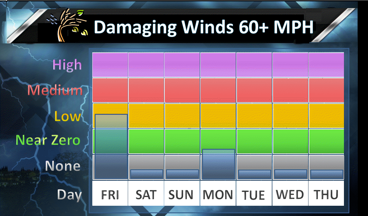
Thunderstorms are likely today. A few of storms could be intense with high winds. Most storms will remain below severe levels. Low end risk for damaging winds.
Locally heavy rain will occur under the thunderstorms. Some areas could pick up 1/2 to 1″ of rain per 30 minutes.
It now appears both Saturday and Sunday will remain dry. This is a change from previous forecasts. Thunderstorm chances may increase Sunday night and Monday as a warm front moves northward from Tennessee.
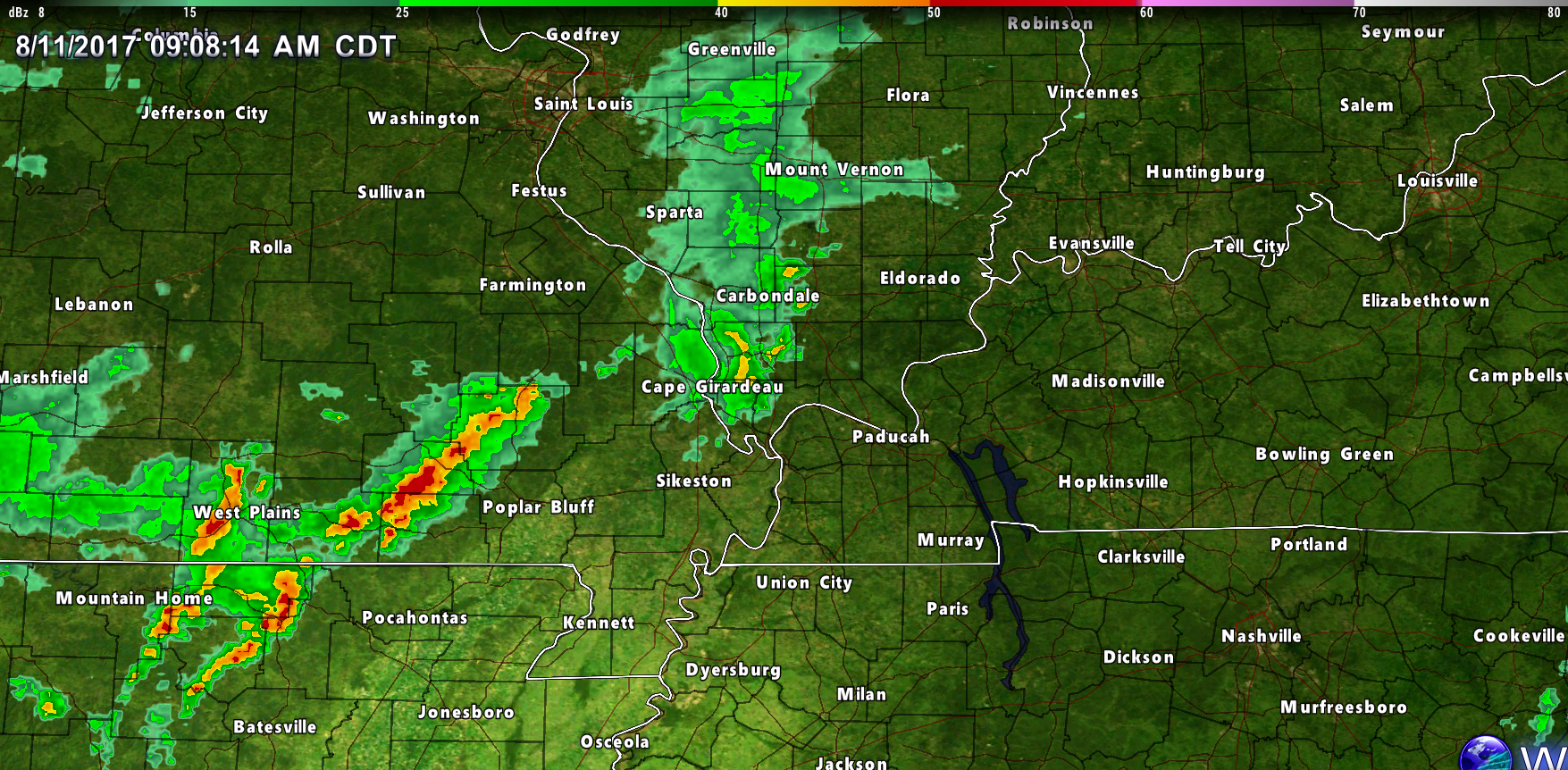
9:15 AM Radar

Storm tracking links
Interaction national radar
http://weather.weatherobservatory.com/interactive/
Your live local city view interactive radars
http://www.weatherobservatory.com/weather-radar.htm
Your Live Paducah City Interactive City View Radar
http://www.weatherobservatory.com/radar_paducah.htm
Your Live Poplar Bluff Interactive City View Radar
http://weatherobservatory.com/radar_pbluff.htm
Your Live Mt Vernon Interactive City View Radar
http://weatherobservatory.com/radar_mtver.htm
Your Live Northeast Arkansas and Missouri Bootheel City View Interactive Radar
http://weatherobservatory.com/radar_memphis.htm
Live Bootheel Interactive City View Radar
http://weatherobservatory.com/radar_dyers.htm
Your Live Purchase Area Interactive Radar
http://weatherobservatory.com/radar_hoptown.htm
Live Northwest Kentucky and Southeast Illinois City View Interactive Radar
http://weatherobservatory.com/radar_evans.htm
Visible satellite (only to be used during the day)
http://weather.weatherobservatory.com/maps/sats/vis/latest/uslowerohvalley.html
Live lightning tracker with zoom and pan features. You can see each bolt and adjust your viewing area. Lightning tracking website


Videos can be viewed at this link. Long Range Video Update
If you believe you missed a video then you can also click the LIVE FEED link on the Weather Talk website. That page holds links for several days.
I can text you the videos, as well. Make sure you have text option FOUR turned on. That would be the Weather Extra text option. Sign up for the text messages at www.beaudodsonweather.com
.

.
This forecast update covers southern Illinois, southeast Missouri, western Kentucky. and northwest Tennessee.
.
The following link is for Weather Text subscribers. This is the page where short and long range video outlooks have been posted. The videos are being produced by a team of meteorologists. Some of the best in the region.
https://weathertalk.com/app/beaucast
.
August 10, 2017
Thursday Night Forecast Details:
Forecast: Partly to mostly cloudy. Scattered evening showers and thunderstorms over mostly southeast Missouri. Smaller chances elsewhere. Mild.
Temperatures: MO ~ 65 to 70 IL ~ 65 to 70 KY ~ 65 to 70 TN ~ 65 to 70
Winds: South and southwest winds at 5 to 10 mph. Winds variable at times.
What impacts are anticipated from the weather? Isolated wet roadways and lightning.
My confidence in the forecast verifying: Medium. Some adjustments are possible.
Is severe weather expected? No
The NWS defines severe weather as 58 mph winds or great, 1″ hail or larger, and/or tornadoes
What is the chance of precipitation? MO ~ 30% IL ~ 20% KY ~ 20% TN ~ 30%
Coverage of precipitation: Isolated to scattered.
Should I cancel my outdoor plans? No, but check radars.
.
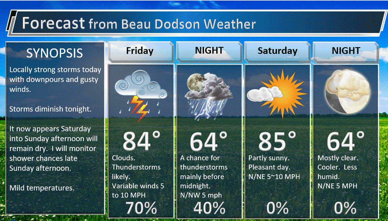
August 11, 2017
Friday Forecast Details
Forecast: Partly to mostly cloudy. Warm. Humid. Showers and thunderstorms.
Temperatures: MO ~ 82 to 86 IL ~ 82 to 86 KY ~ 82 to 86 TN ~ 82 to 86
Winds: South and southwest winds at 5 to 10 mph with gusts to 12 mph.
What impacts are anticipated from the weather? Wet roadways and lightning.
My confidence in the forecast verifying: Medium. Some adjustments are possible.
Is severe weather expected? Small risk for damaging winds.
The NWS defines severe weather as 58 mph winds or great, 1″ hail or larger, and/or tornadoes
What is the chance of precipitation? MO ~ 70% IL ~ 70% KY ~ 70% TN ~ 70%
Coverage of precipitation: Scattered to numerous.
Should I cancel my outdoor plans? No, but check updates.
.
Friday Night Forecast Details:
Forecast: Quite a few clouds. Any remaining showers and thunderstorms will come to an end. Cooler north vs south. A boundary will divide the area.
Temperatures: MO ~ 62 to 68 (cooler northern counties vs south) IL ~ 60 to 70 (cooler northern counties vs southern) KY ~ 65 to 70 TN ~ 65 to 70
Winds: Variable winds at 5 to 10 mph. winds becoming west/southwest.
What impacts are anticipated from the weather? Scattered wet roadways and lightning.
My confidence in the forecast verifying: Medium. Some adjustments are possible.
Is severe weather expected? A few storms could produce strong winds. Low severe weather risk.
The NWS defines severe weather as 58 mph winds or great, 1″ hail or larger, and/or tornadoes
What is the chance of precipitation? MO ~ 40% IL ~ 40% KY ~ 40% TN ~ 40%
Coverage of precipitation: Scattered.
Should I cancel my outdoor plans? No, but I would check radars and updated numbers.
.
August 12, 2017
Saturday Forecast Details
Forecast: Partly to mostly sunny. A small chance for a thunderstorm. Most of the region should be dry.
Temperatures: MO ~ 82 to 86 IL ~ 82 to 86 KY ~ 82 to 86 TN ~ 82 to 86
Winds: Northerly winds at 5 to 10 mph with gusts to 14 mph.
What impacts are anticipated from the weather? Most likely none. Small chance for wet roadways and lightning along the KY/TN border southward.
My confidence in the forecast verifying: Medium. Some adjustments possible.
Is severe weather expected? No
The NWS defines severe weather as 58 mph winds or great, 1″ hail or larger, and/or tornadoes
What is the chance of precipitation? MO ~ 20% IL ~ 10% KY ~ 20% TN ~ 30%
Coverage of precipitation: Isolated to none.
Should I cancel my outdoor plans? No, but check updates.
.
Saturday Night Forecast Details:
Forecast: Partly to mostly cloudy. Isolated shows and thunderstorms possible.
Temperatures: MO ~ 65 to 70 IL ~ 65 to 70 KY ~ 65 to 70 TN ~ 65 to 70
Winds: Variable winds at 5 to 10 mph. Winds mostly northerly.
What impacts are anticipated from the weather? Most likely none. Isolated wet roadways and lightning.
My confidence in the forecast verifying: Low. Significant adjustments possible
Is severe weather expected? No
The NWS defines severe weather as 58 mph winds or great, 1″ hail or larger, and/or tornadoes
What is the chance of precipitation? MO ~ 20% IL ~ 20% KY ~ 30% TN ~ 30%
Coverage of precipitation: Isolated
Should I cancel my outdoor plans? No, but check updates.
.
August 13, 2017
Sunday Forecast Details
Forecast: Partly sunny.
Temperatures: MO ~ 80 to 85 IL ~ 80 to 85 KY ~ 80 to 85 TN ~ 80 to 85
Winds: Variable winds at 5 to 10 mph with gusts to 14 mph.
What impacts are anticipated from the weather? Most likely none.
My confidence in the forecast verifying: Medium. Some adjustments possible.
Is severe weather expected? No.
The NWS defines severe weather as 58 mph winds or great, 1″ hail or larger, and/or tornadoes
What is the chance of precipitation? MO ~ 10% IL ~ 10% KY ~ 10% TN ~ 10%
Coverage of precipitation: Most likely none.
Should I cancel my outdoor plans? No
.
Sunday Night Forecast Details:
Forecast: Partly cloudy. Scattered showers and thunderstorms possible late.
Temperatures: MO ~ 64 to 68 IL ~ 64 to 68 KY ~ 64 to 68 TN ~ 64 to 68
Winds: North and northeast winds at 4 to 8 mph
What impacts are anticipated from the weather? Scattered wet roadways and lightning.
My confidence in the forecast verifying: Low. Significant adjustments possible.
Is severe weather expected? Unlikely, but monitor updates
The NWS defines severe weather as 58 mph winds or great, 1″ hail or larger, and/or tornadoes
What is the chance of precipitation? MO ~ 40% IL ~ 40% KY ~ 40% TN ~ 40%
Coverage of precipitation: Isolated to scattered.
Should I cancel my outdoor plans? No, but check updates
.
August 14, 2017
Monday Forecast Details
Forecast: Partly sunny. A chance for scattered thunderstorms.
Temperatures: MO ~ 76 to 84 IL ~ 76 to 84 KY ~ 76 to 84 TN ~ 76 to 84
Winds: East winds at 5 to 10 mph with gusts to 15 mph.
What impacts are anticipated from the weather? Wet roadways. Lightning.
My confidence in the forecast verifying: Low. Significant adjustments possible.
Is severe weather expected? Unlikely.
The NWS defines severe weather as 58 mph winds or great, 1″ hail or larger, and/or tornadoes
What is the chance of precipitation? MO ~ 40% IL ~ 40% KY ~ 40% TN ~ 40%
Coverage of precipitation: Scattered.
Should I cancel my outdoor plans? No, but check updates. There will be a cold front near our region. Rain is possible.
.
Monday Night Forecast Details:
Forecast: Partly cloudy. Isolated showers and thunderstorms possible.
Temperatures: MO ~ 65 to 70 IL ~ 65 to 70 KY ~ 65 to 70 TN ~ 65 to 70
Winds: Variable winds at 5 to 10 mph
What impacts are anticipated from the weather? Scattered wet roadways and lightning.
My confidence in the forecast verifying: Low. Significant adjustments possible
Is severe weather expected? No
The NWS defines severe weather as 58 mph winds or great, 1″ hail or larger, and/or tornadoes
What is the chance of precipitation? MO ~ 30% IL ~ 30% KY ~ 30% TN ~ 30%
Coverage of precipitation: Isolated
Should I cancel my outdoor plans? No
.
August 15, 2017
Tuesday Forecast Details
Forecast: Partly to mostly sunny.
Temperatures: MO ~ 75 to 80 IL ~ 75 to 80 KY ~ 75 to 80 TN ~ 75 to 80
Winds: North and northeast winds at 5 to 10 mph.
What impacts are anticipated from the weather? Most likely none.
My confidence in the forecast verifying: Low. Significant adjustments possible.
Is severe weather expected? No
The NWS defines severe weather as 58 mph winds or great, 1″ hail or larger, and/or tornadoes
What is the chance of precipitation? MO ~ 10% IL ~ 10% KY ~ 10% TN ~ 10%
Coverage of precipitation: Most likely none
Should I cancel my outdoor plans? No
.
Tuesday Night Forecast Details:
Forecast: Partly cloudy.
Temperatures: MO ~ 65 to 70 IL ~ 65 to 70 KY ~ 65 to 70 TN ~ 65 to 70
Winds: North and northeast winds at 5 to 10 mph
What impacts are anticipated from the weather?
My confidence in the forecast verifying: Medium. Some adjustments possible.
Is severe weather expected?
The NWS defines severe weather as 58 mph winds or great, 1″ hail or larger, and/or tornadoes
What is the chance of precipitation? MO ~ 20% IL ~ 20% KY ~ 20% TN ~ 20%
Coverage of precipitation:
Should I cancel my outdoor plans.
.
August 15, 2017
Wednesday Forecast Details
Forecast: Mostly sunny. Mild.
Temperatures: MO ~ 80 to 85 IL ~ 80 to 85 KY ~ 80 to 85 TN ~ 80 to 85
Winds: Light and variable
What impacts are anticipated from the weather? None
My confidence in the forecast verifying: Low. Significant adjustments possible.
Is severe weather expected? No
The NWS defines severe weather as 58 mph winds or great, 1″ hail or larger, and/or tornadoes
What is the chance of precipitation? MO ~ 0% IL ~ 0% KY ~ 0% TN ~ 0%
Coverage of precipitation: None
Should I cancel my outdoor plans? No
.
Wednesday Night Forecast Details:
Forecast: Partly cloudy.
Temperatures: MO ~ 65 to 70 IL ~ 65 to 70 KY ~ 65 to 70 TN ~ 65 to 70
Winds: Variable less than 10 mph
What impacts are anticipated from the weather? None
My confidence in the forecast verifying: Low. Significant adjustments are possible.
Is severe weather expected? No
The NWS defines severe weather as 58 mph winds or great, 1″ hail or larger, and/or tornadoes
What is the chance of precipitation? MO ~ 0% IL ~ 0% KY ~ 0% TN ~ 0%
Coverage of precipitation: None
Should I cancel my outdoor plans? No
.

Don’t forget to check out the Southern Illinois Weather Observatory web-site for weather maps, tower cams, scanner feeds, radars, and much more! Click here

A severe thunderstorm is defined as a storm that produces quarter size hail or larger, 58 mph winds or greater, and/or a tornado. That is the official National Weather Service definition of a severe thunderstorm.
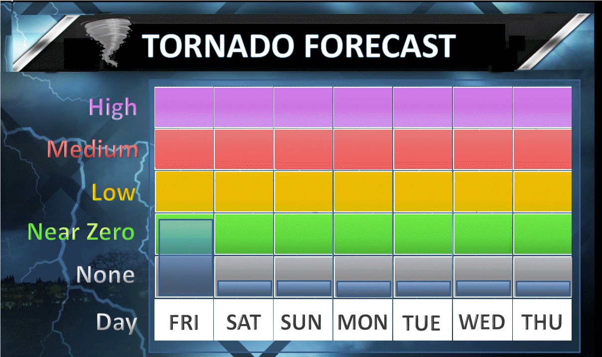
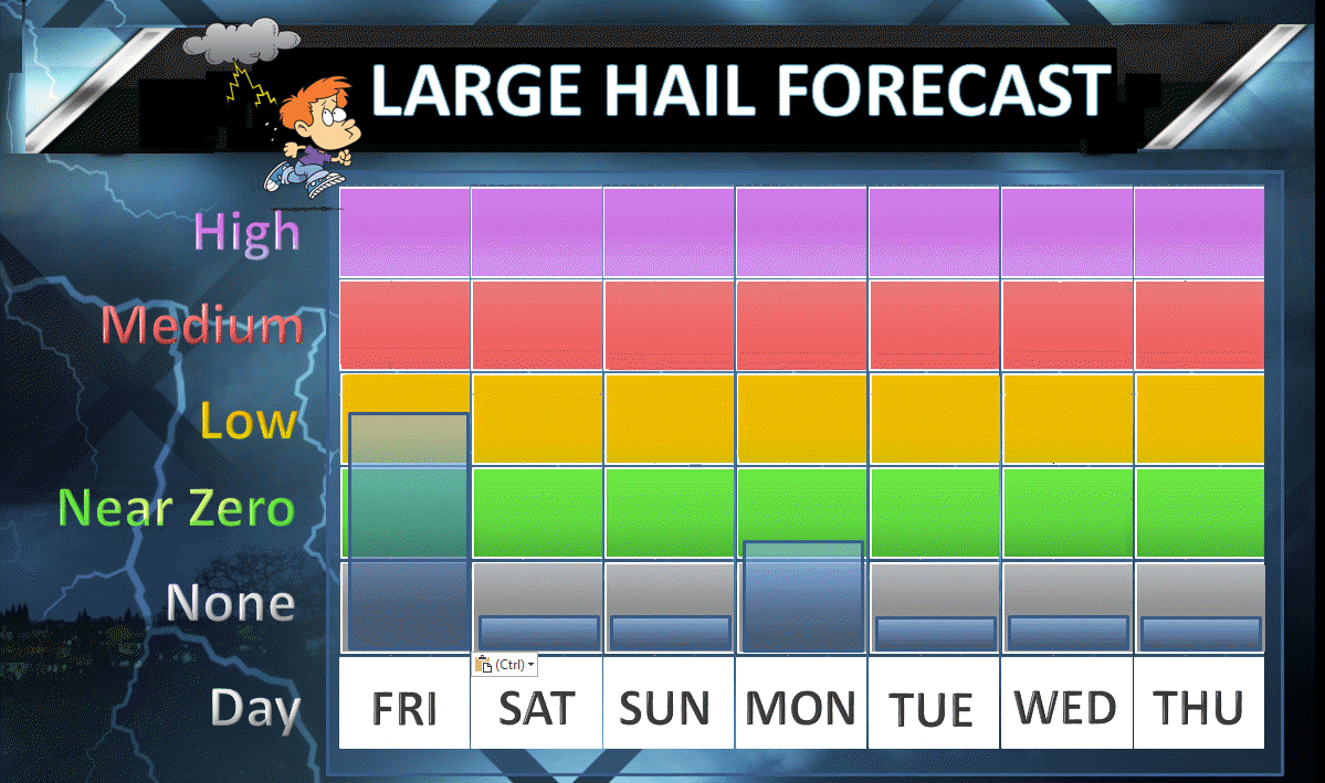
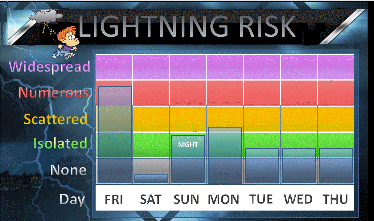
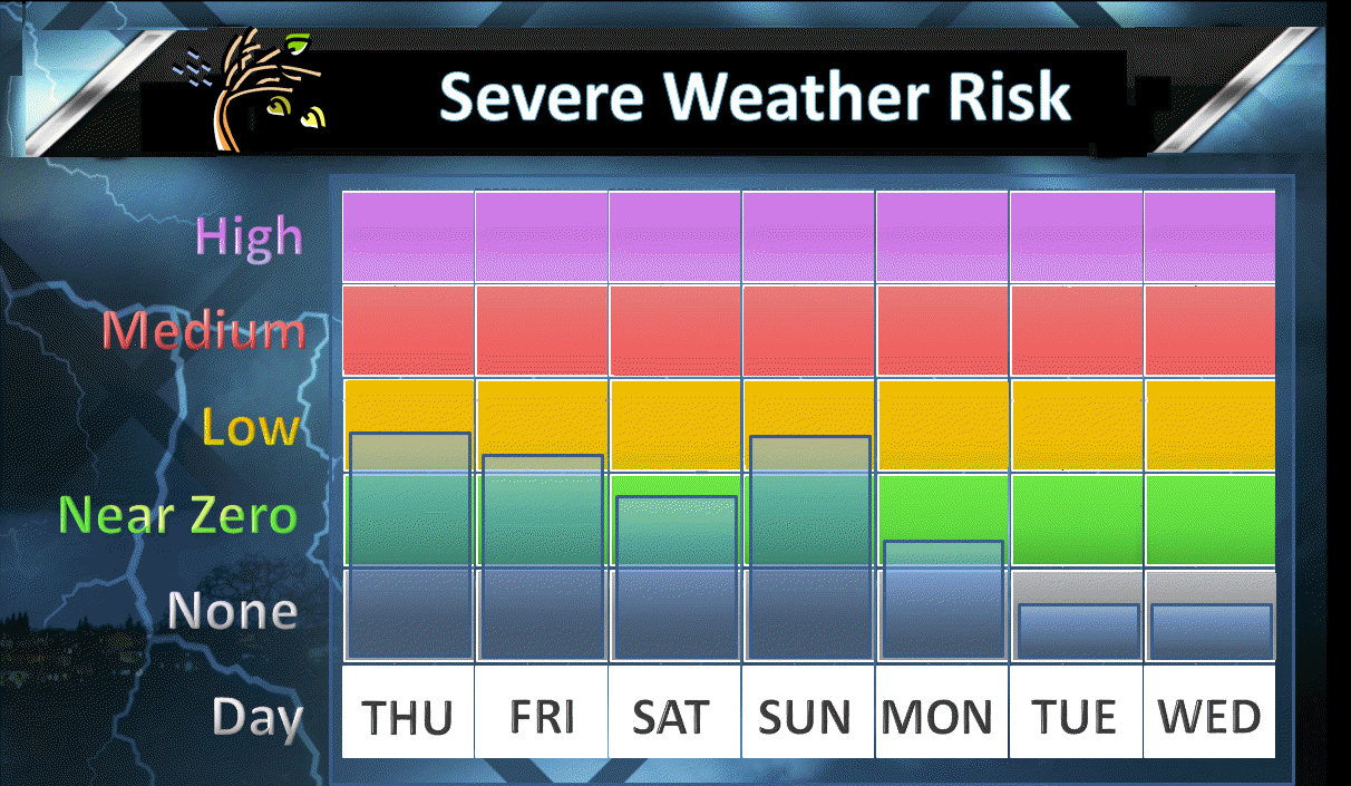
Thursday night through Monday: Severe weather is not anticipated.
We will have thunderstorms in the forecast, but the severe weather risk is low. Lightning will be the main concern. A couple of storms could produce high winds, but the overall risk is low.
If stronger storms were to occur they would most likely be on Friday and again on Sunday.

A fairly active weather pattern over the coming days. Plenty to monitor.
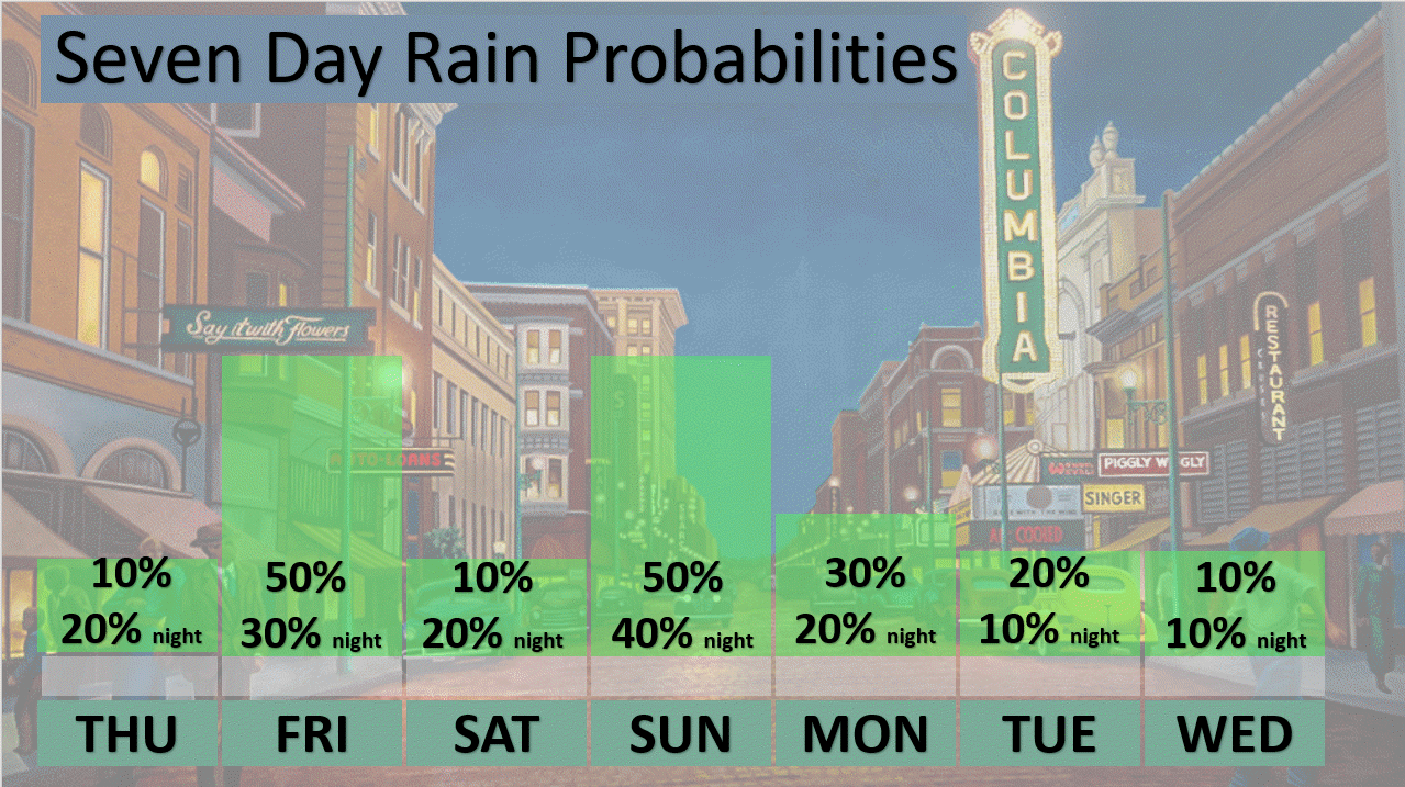
A few showers and thunderstorms will be possible this evening and tonight. The best chance would be over northern parts of southeast Missouri and a sliver of southwest Illinois. Majority of the region will have lower rain chances and should remain dry.
See local radars to check on precipitation
Looking ahead
We have a few weak disturbances to monitor over the coming days. Each will deliver rain and thunderstorm chances. The problem is timing and coverage.
I have two peak time periods for showers and thunderstorms. One of those will be Friday and the other will be Sunday.
This has not been an easy forecast. At one time Saturday appeared to be a widespread rain event. Now, guidance is showing sunshine. This is one reason I have been telling everyone to check back frequently for updates.
Confidence is lower than normal in the overall forecast. Timing these weak disturbances is tricky. Even trickier is how much rain coverage to paint on the weather map.
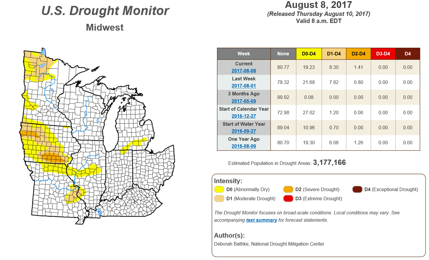
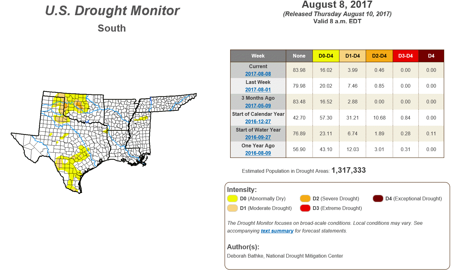
We do need rain. Much of the region is and has been drier than normal for the past four to six weeks. Yes, some of you have experienced decent rain, but many have not.
Here is the updated drought monitor map (click to enlarge)
and
I did make some adjustments this morning (esp for Saturday). I was thinking today is when confidence would grow (as far as the details).
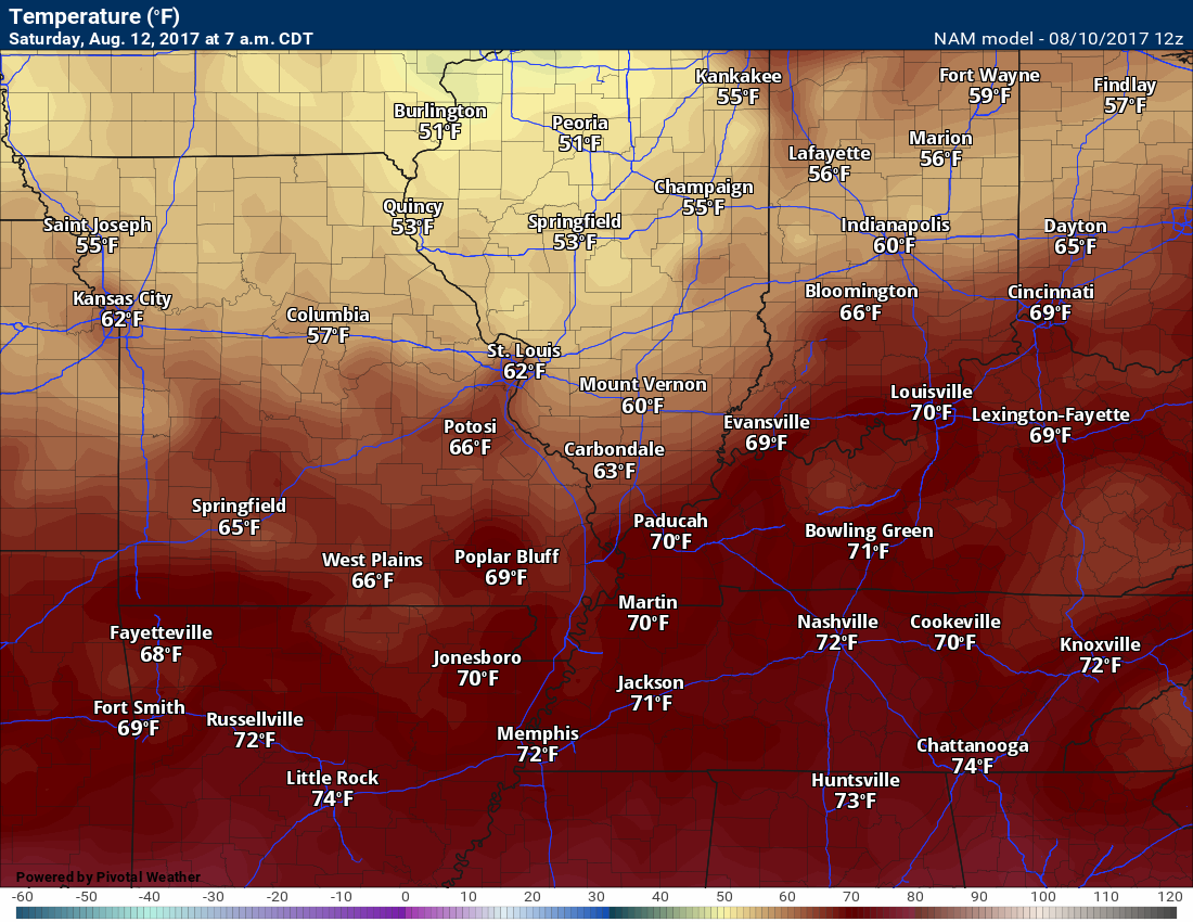
There might be a bit of a temperature range Saturday. This will depend on the placement of the frontal boundary.
Forecast lows for Saturday morning.
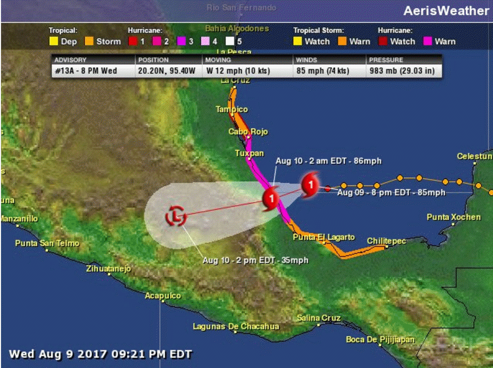
Hurricane Franklin will continue to push into Mexico over the coming days. It appears that the moisture for Franklin will remain to our south and southwest. Occasionally, systems like this will push moisture into our region. It appears that is unlikely with Franklin.
Franklin
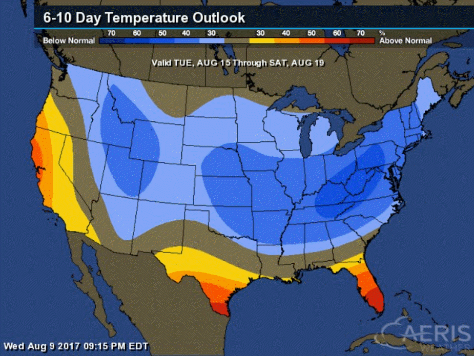
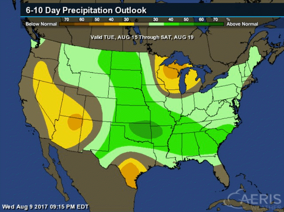
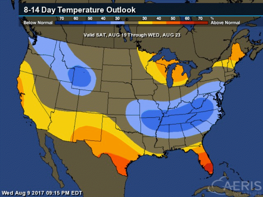
Here are the updated six to ten day temperature and precipitation probability maps.
What is the percentage chance of them averaging normal, below normal, or above normal.
Six to ten day temperature outlook for Tuesday, August 15th through Saturday, August 19th
As you can see, probabilities favor below normal temperatures and above normal precipitation.
Six to ten day precipitation outlook for Tuesday, August 15th through Saturday, August 19th
Eight to fourteen day temperature outlook for Saturday, August 19th through Wednesday, August 23rd
Eight to fourteen day precipitation outlook for Saturday, August 19th through Wednesday, August 23rd

Eclipse Weather
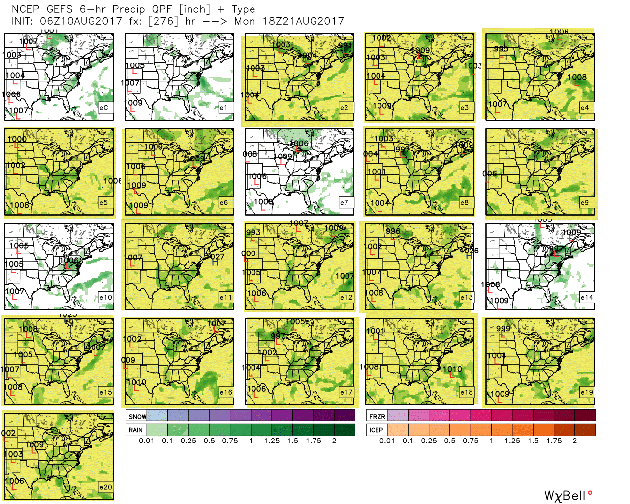
Ensembles are showing rain and clouds for the eclipse. It is still way too early for a real forecast, but I don’t like the ensembles. They would indicate poor viewing conditions. Let’s hope they are wrong.
This is the same model, but run with slightly different beginning parameters. The goal is to see how many of the panels agree. Large agreement raises confidence in the forecast. We are pushing the envelop for extended range. PLENTY of days to monitor. Plenty of days for adjustments. Confidence in the forecast probably won’t rise until next Thursday.
The EC guidance is drier than the GFS guidance. Battle of the models. Long way off, still.
Right now, the yellow boxes indicate a model run that shows clouds and rain. Obviously, this is not great news. The good news, however, is that we still have many days left for adjustments and changes.
Fingers crossed.
Are you subscribing to the Weather Talk texts and videos?
We now have premiere videos for the short and long range forecasts! Make sure you have text option four turned on (green).
Sign up at www.beaudodsonweather.com
We also have an Apple and Android app (scroll down to bottom of the page for more information)

Were you aware that I have hired some help for long range videos? Short range videos, as well. An amazing team of meteorologists.
Click the link below to read more
http://cms.weathertalk.com/meet-the-team/
Weather Talk subscribers now have some of the best short and long range weather videos produced across the eastern United States.
.

Find me on Twitter
.

We have regional radars and local city radars – if a radar does not update then try another one. Occasional browsers need their cache cleared. You may also try restarting your browser. That usually fixes the problem. Occasionally we do have a radar go down. That is why I have duplicates. Thus, if one fails then try another one.
During the winter you can track snow and ice by clicking the winterize button on the local city view interactive radars.
If you have any problems then please send me an email beaudodson@usawx.com
Interactive Weather Radar Page. Choose the city nearest your location: Click this link—
National interactive radar: Click this link.
Local interactive city radars include St Louis, Mt Vernon, Evansville, Poplar Bluff, Cape Girardeau, Marion, Paducah, Hopkinsville, Memphis, Nashville, Dyersburg, and all of eastern Kentucky. These are interactive radars. Local city radars – click here
The Beau Dodson Weather APP is ready for Apple and Android users. The purpose of this app is for me to deliver your text messages instantly. ATT and Verizon have not always been reliable when it comes to speed. The app allows instant delivery.
Some of you have asked if you can keep receiving the texts on your phone and the app. The answer to that is, yes. The Android app will automatically allow that to happen. On the Apple app, however, you will need to go into your app and click settings. Make sure the green tab is OFF. Off means you will still receive the texts to your phone and the app. If you have any questions, then email me at beaudodson@usawx.com
The app is for text subscribers.
The direct download, for the Apple app, can be viewed here
https://itunes.apple.com/us/app/id1190136514
If you have not signed up for the texting service then you may do so at www.beaudodsonweather.com

The Android app is also ready.
Remember, the app’s are for www.weathertalk.com subscribers. The app allows your to receive the text messages faster than ATT and Verizon.
Here is the download link for the Android version Click Here

——————————————————–
If you have not signed up for the texts messages, then please do. Link www.beaudodsonweather.com
Your support helps with the following:

and


Who do you trust for your weather information and who holds them accountable?
I have studied weather in our region since the late 1970’s. I have 39 years of experience in observing our regions weather patterns. My degree is in Broadcast Meteorology and a Bachelor’s of Science.
My resume includes:
Member of the American Meteorological Society.
NOAA Weather-Ready Nation Ambassador.
Meteorologist for McCracken County Emergency Management. I served from 2005 through 2015.
Meteorologist for McCracken County Rescue. 2015 through current
I own and operate the Southern Illinois Weather Observatory.
I am the chief meteorologist for Weather Talk LLC. I am the owner of Weather Talk LLC.
I am also a business owner in western Kentucky.
Recipient of the Mark Trail Award, WPSD Six Who Make A Difference Award, Kentucky Colonel, and the Caesar J. Fiamma” Award from the American Red Cross.
In 2005 I helped open the largest American Cross shelter in U.S. history in Houston, Texas. I was deployed to help after Hurricane Katrina and Hurricane Rita. I was a shelter manager of one of the Houston, Texas shelter divisions.
In 2009 I was presented with the Kentucky Office of Highway Safety Award.
Recognized by the Kentucky House of Representatives for my service to the State of Kentucky leading up to several winter storms and severe weather outbreaks.
If you click on the image below you can read the Kentucky House of Representatives Resolution.

I am also President of the Shadow Angel Foundation which serves portions of western Kentucky and southern Illinois.
There is a lot of noise on the internet. A lot of weather maps are posted without explanation. Over time you should learn who to trust for your weather information.
My forecast philosophy is simple and straight forward.
- Communicate in simple terms
- To be as accurate as possible within a reasonable time frame before an event
- Interact with you on Twitter, Facebook, email, texts, and this blog
- Minimize the “hype” that you might see on some television stations or through other weather sources
- Push you towards utilizing wall-to-wall LOCAL TV coverage during severe weather events
Many of the graphics on this page are from www.weatherbell.com
WeatherBell is a great resource for weather model guidance.


You can sign up for my AWARE email by clicking here I typically send out AWARE emails before severe weather, winter storms, or other active weather situations. I do not email watches or warnings. The emails are a basic “heads up” concerning incoming weather conditions