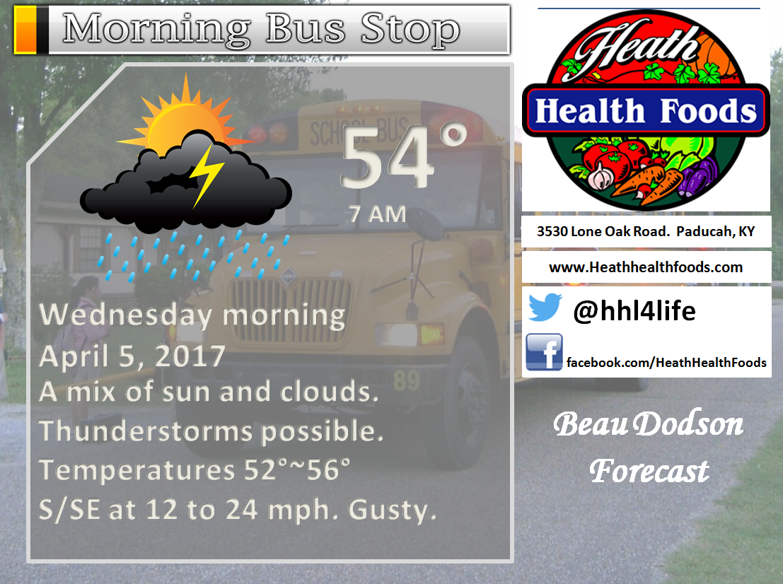
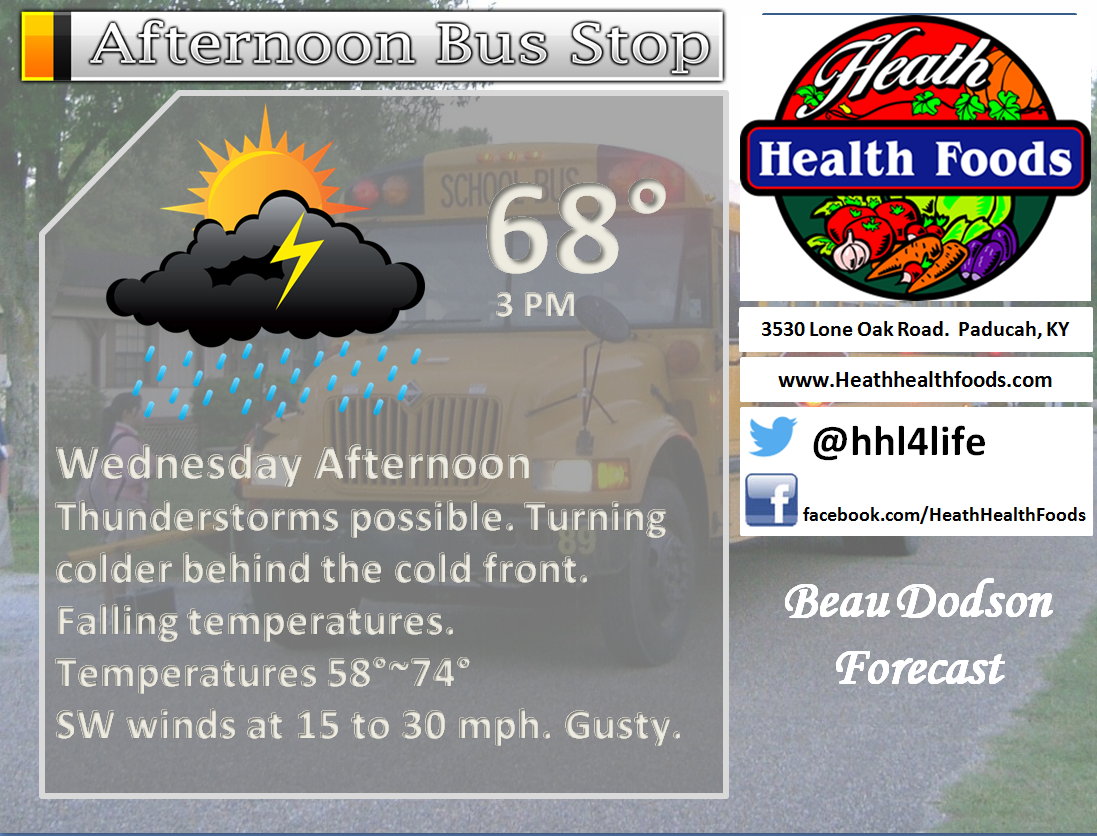
April 5, 2017
8 AM update
April 5, 2017: Severe weather update thread for 8 AM through 12 PM
Main concern for severe thunderstorms will be areas from southeast Illinois into the Pennyrile area of western Kentucky and then south and east from there.
This would include cities such as Owensboro, Madisonville, Central City, Crofton, and Hopkinsville. Those cities eastward have the greatest risk.
Areas west of there will have some risk, but perhaps not as great. That would include portions of southern Illinois and western Kentucky. Less risk for Missouri and northwest Tennessee.
The zone could shift slightly to the west or east in future updates.
Time frame of concern will be 12 pm through 4 pm.
A significant severe weather event is possible over portions of southern Indiana into central Kentucky and then southward from there to the Gulf of Mexico.
This event may clip our region, but questions remain on placement of a few severe thunderstorms later today.
An area of low pressure is currently located in central Missouri. This low will move east and northeast over the coming hours. A strong cold front extends from the low southward into Arkansas.
The cold front will sweep across our region today. Temperatures will rise into the upper 60’s to middle 70’s ahead of the front. Temperatures will fall into the 50’s behind the front. Temperatures may actually fall this afternoon as the front moves east.
Supercells are likely to develop in the warm sector of this system. The warm sector is to the east and south of the area of low pressure.
Morning cloud cover, showers, and thunderstorms have helped stabilize the atmosphere. This is good news.
There are, however, some breaks in the clouds. Any heating today will increase CAPE numbers over southern Illinois and western Kentucky (perhaps NW Tennessee, as well).
The atmosphere will become increasingly unstable later this morning and afternoon. This will result in new thunderstorms firing along and ahead of the cold front.
The current thinking (medium confidence) is that storms will reform along or east of the Mississippi River. That would mean southern Illinois into western Kentucky and Tennessee.
There is a small window of time where severe weather could occur today. That time window is 12 pm through 3 pm. The further east you travel the greater the risk for severe thunderstorms.
Golf ball to baseball size hail, 70+ mph winds, and tornadoes (some strong) are possible near our eastern counties this afternoon. Perhaps just to the east of my forecast area, but too close to call..
A have greater concerns for southern Indiana into central Kentucky and then southward.
A tornado watch will likely be issued after 11 am for portions of our region. Monitor watches and warnings.
A watch means to monitor updates. A warning means to take action and seek shelter.
Storms will move at speeds of 55 to 70+ mph. Fast movers.
Storms end this evening. Clouds linger into Thursday. Light rain showers possible before noon on Thursday.
Dry Thursday night through Sunday afternoon. Frost not out of the question Thursday night. Killing frost unlikely. Monitor updates if you have concerns.
Focus today will be on today.
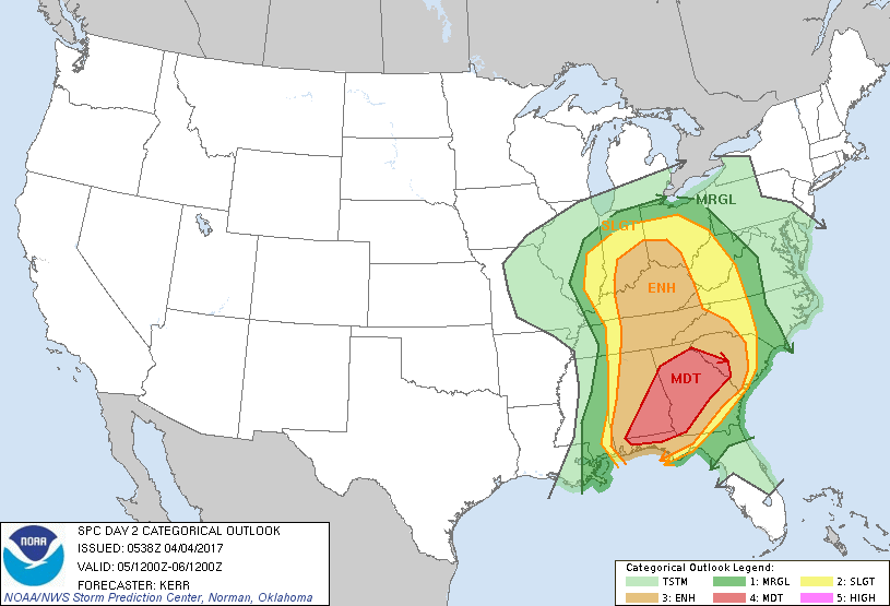
A few graphics
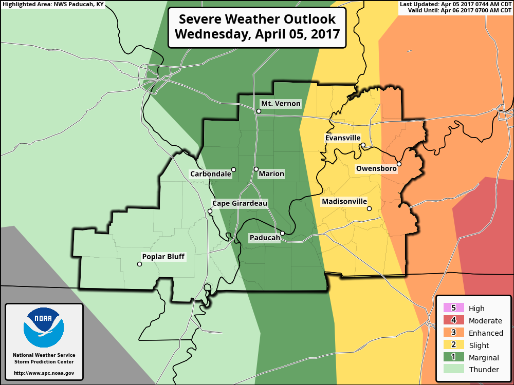
Here is the latest severe weather outlook. Yellow, orange, and red are the highest risk zones.
Our eastern counties are under the greatest risk for severe storms later today.
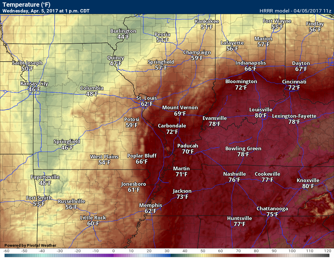
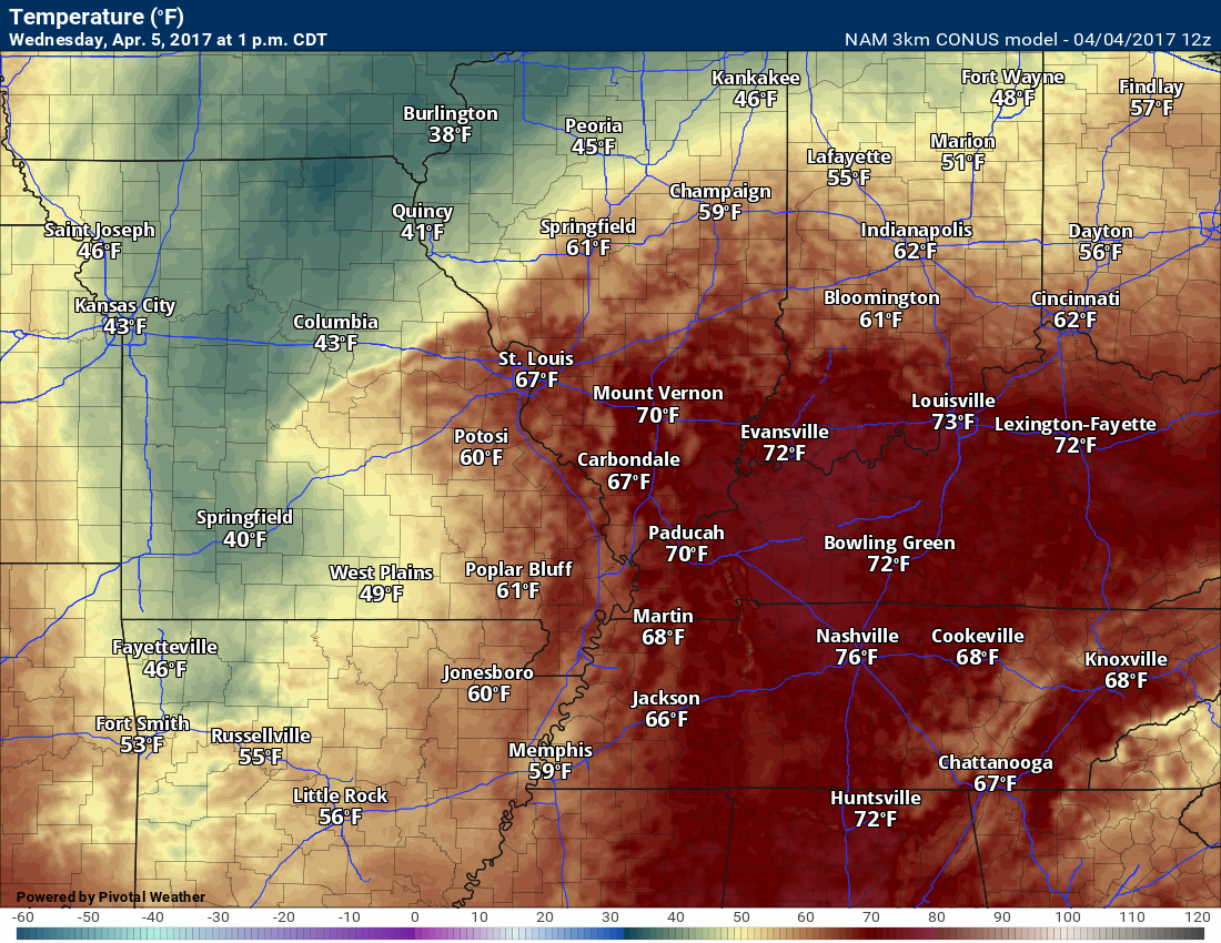
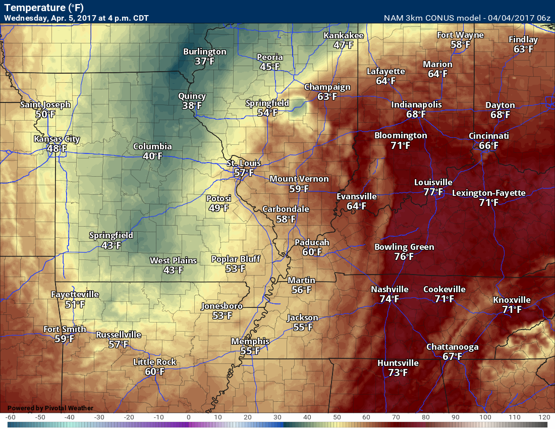
Check out the temperature spread later today! You can tell a cold front is moving through the area.
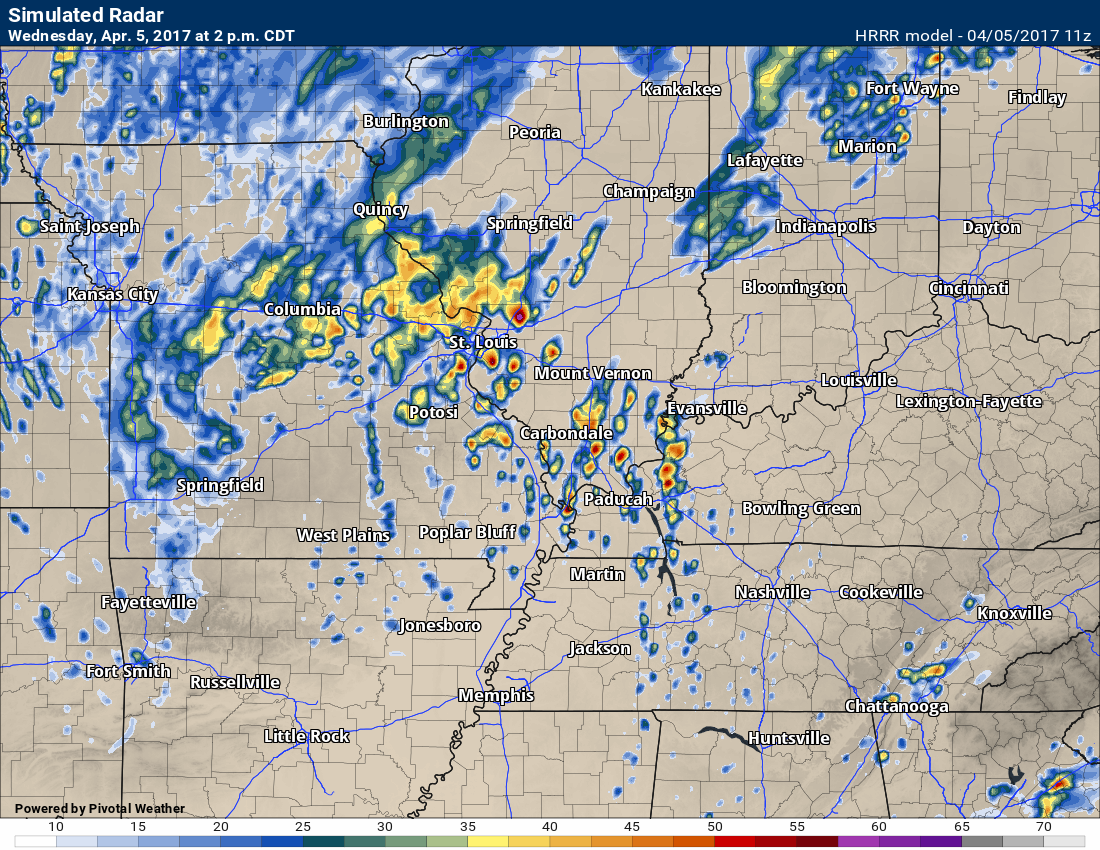
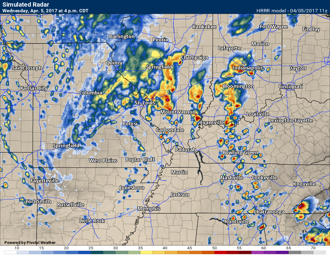
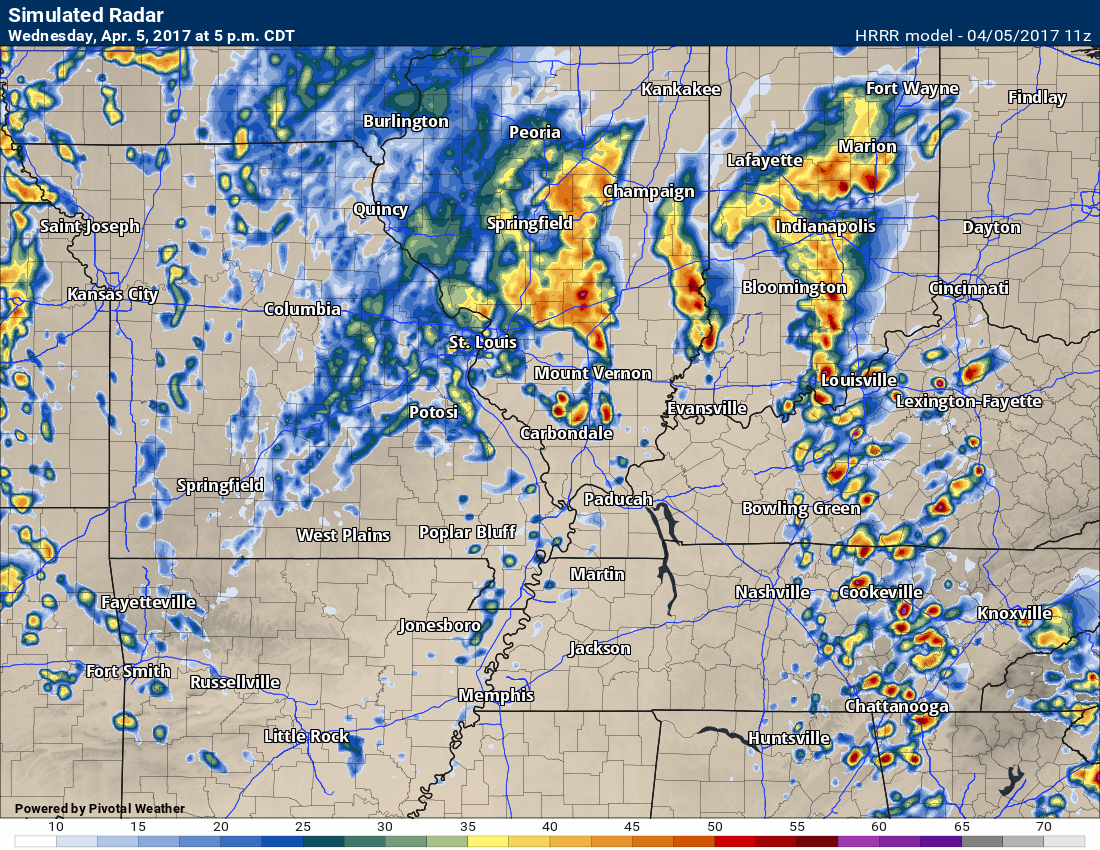
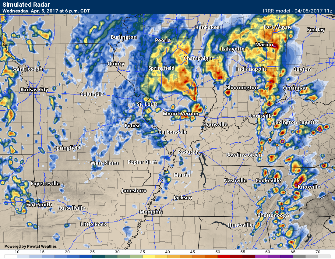
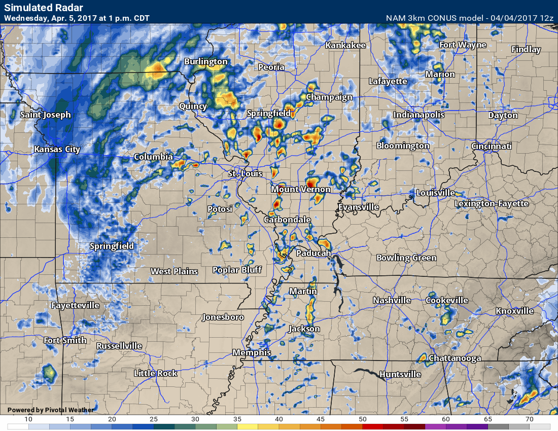
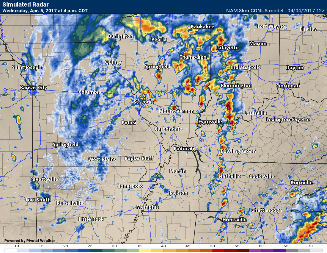
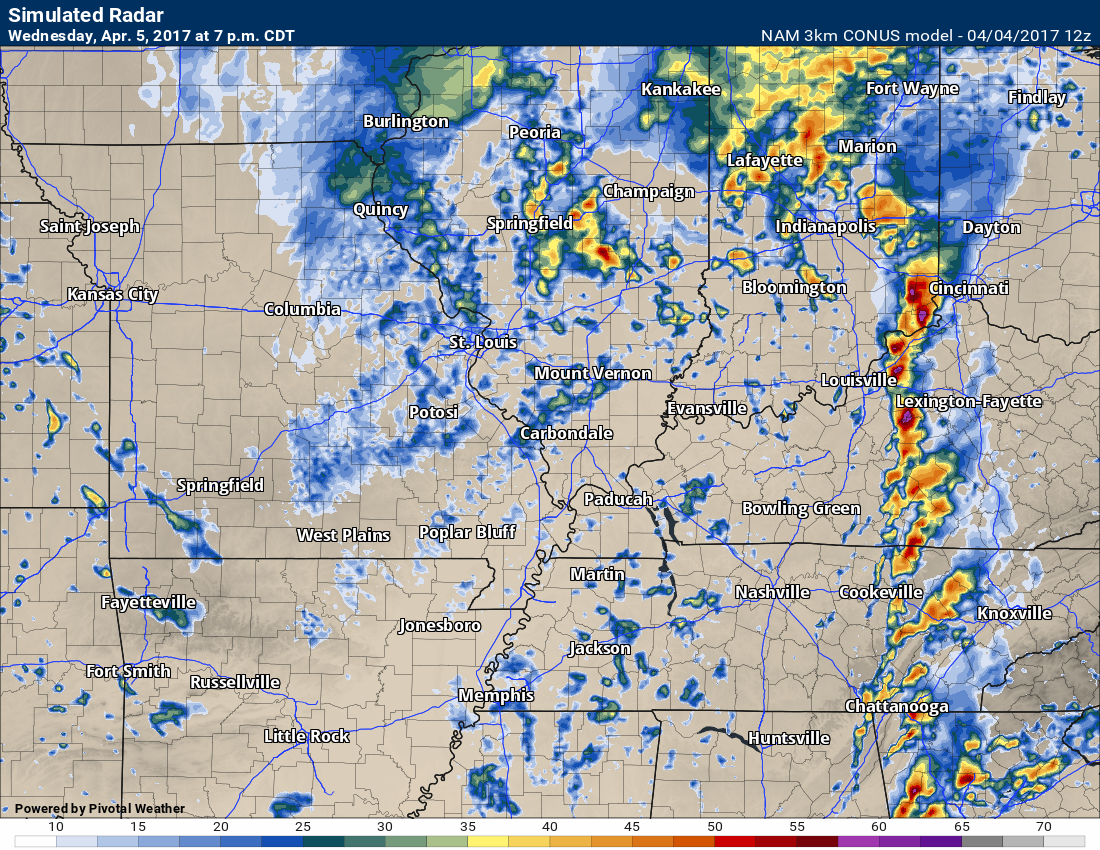
Future-cast radar.
What radar MIGHT look like later today. This won’t be exact. Take generalities from it.
2 PM HRRR future-cast radar
Brighter colors equal heavier storms.
4 PM future-cast radar
5 PM future-cast radar
6 PM future-cast radar

This forecast update covers far southern Illinois, far southeast Missouri, and far western Kentucky. See the coverage map on the right side of the blog
.
Interactive Weather Radar Page. Choose the city nearest your location: Click this link
.
April 4, 2017
Tuesday Night Forecast Details:
Forecast: Becoming cloudy. A 20% for a shower or storms before 10 pm. A 60% for showers and thunderstorms over southeast Missouri after 10 pm. A 30% to 40% for showers and storms over the rest of the area after midnight. Winds becoming strong and gusty late tonight.
Temperatures: MO ~ 55 to 60 IL ~ 55 to 60 KY ~ 56 to 62 TN ~ 56 to 62
Winds: Winds becoming southeast at 7 to 14 before midnight and then 12 to 24 mph with gusts to 35 mph late tonight.
My confidence in the forecast verifying: Medium. Some adjustments are possible.
What impacts are anticipated from the weather? Wet roadways. Lightning. Strong and gusty winds.
Is severe weather expected? Unlikely, but I will be monitoring southeast Missouri as a line of storms advances into the region late tonight.
The NWS defines severe weather as 58 mph winds or great, 1″ hail or larger, and/or tornadoes
What is the chance of precipitation? MO ~ 60% IL ~ 40% KY ~ 30% TN ~ 30%
Coverage of precipitation: Scattered showers before midnight. Numerous showers and storms late tonight. Highest coverage will be over southeast Missouri.
Should I cancel my outdoor plans? No
.
Interactive Weather Radar Page. Choose the city nearest your location: Click this link—
.
April 5, 2017
Wednesday Forecast Details
Monitor late morning into the afternoon for some strong to severe storms (esp southeast Illinois into the Pennyrile area of western Kentucky and then east from there)
Forecast: A mix of sun and clouds. Warm. Windy. One round of morning storms and then a second round during the late morning/afternoon hours. Some of the storms over southern Illinois and western Kentucky could be intense. Falling temperatures behind the main band of afternoon storms. Some areas should fall into the 50’s after frontal passage.
Temperatures: MO ~ 68 to 74 IL ~ 66 to 74 KY ~ 70 to 76 TN ~ 70 to 76 Falling temperatures behind the front.
Winds: South and southwest winds at 12 to 24 mph with gusts above 35 mph. Winds may turn more west/southwest after the cold front passes your location.
What impacts are anticipated from the weather? Wet roadways. Lightning. Monitoring the severe weather potential. Strong and gusty winds.
My confidence in the forecast verifying: High. This forecast should verify.
Is severe weather expected? Monitor updates. Some storms, especially over southern Illinois and western Kentucky, could produce hail and high winds. Tornado risk will need to be monitored.
The NWS defines severe weather as 58 mph winds or great, 1″ hail or larger, and/or tornadoes
What is the chance of precipitation? MO ~ 40% IL ~ 60% KY ~ 60% Northwest TN ~ 50%
Coverage of precipitation: Scattered to numerous showers and storms possible.
Should I cancel my outdoor plans? I would monitor updates and have a plan B. On and off shower/storm chances.
Sunrise will be at 6:32 a.m. and sunset will be at 7:21 p.m.
Wednesday Night Forecast Details:
Forecast: Windy. Cloudy with evening showers and storms. Showers becoming more scattered as we move deeper into the night. Colder. Some clearing late.
Temperatures: MO ~ 36 to 44 IL ~ 36 to 44 KY ~ 36 to 44 TN ~ 36 to 44
Winds: West and northwest at 10 to 20 mph with gusts above 40 mph possible.
My confidence in the forecast verifying: Medium. Some adjustments are possible.
What impacts are anticipated from the weather? Strong winds. Wet roadways. Lightning.
Is severe weather expected? Monitor updates for the early evening hours.
The NWS defines severe weather as 58 mph winds or great, 1″ hail or larger, and/or tornadoes
What is the chance of precipitation? MO ~ 40% IL ~ 50% KY ~ 50% TN ~ 50%
Coverage of precipitation: Precipitation should be ending from west to east on Wednesday evening. Scattered showers possible late.
Should I cancel my outdoor plans? Strong winds could interfere with outdoor activities. Rain should be on the way out by Wednesday evening.
.
Thursday Forecast Details
Forecast: Partly to mostly cloudy. Windy. Much cooler. A few light showers possible.
Temperatures: MO ~ 48 to 54 IL ~ 48 to 54 KY ~ 50 to 55 TN ~ 50 to 55
Winds: Northwest. Strong and gusty. Winds of 10 to 20 mph with gusts above 30 mph before noon.
What impacts are anticipated from the weather? Windy.
My confidence in the forecast verifying: Medium. Some adjustments are possible.
Is severe weather expected? No
The NWS defines severe weather as 58 mph winds or great, 1″ hail or larger, and/or tornadoes
What is the chance of precipitation? MO ~ 20% IL ~ 30% KY ~ 30% TN ~ 30%
Coverage of precipitation: Scattered showers possible (mainly morning).
Should I cancel my outdoor plans? Much cooler with strong and gusty winds. Spotty shower. Not the best day outside.
Sunrise will be at 6:32 a.m. and sunset will be at 7:21 p.m.
Thursday Night Forecast Details:
Forecast: Mostly clear and cold.
Temperatures: MO ~ 36 to 44 IL ~ 36 to 44 KY ~ 36 to 44 TN ~ 36 to 44
Winds: Northwest winds at 6 to 12 mph.
My confidence in the forecast verifying: Medium. Some adjustments are possible.
What impacts are anticipated from the weather? Most likely none. I am monitoring the frost potential.
Is severe weather expected? No.
The NWS defines severe weather as 58 mph winds or great, 1″ hail or larger, and/or tornadoes
What is the chance of precipitation? MO ~ 0% IL ~ 0% KY ~ 0% TN ~ 0%
Coverage of precipitation: None.
Should I cancel my outdoor plans? No
Dry weather Friday into Sunday. Highs in the 50’s on Friday, 60’s on Saturday, and perhaps 70’s on Sunday.
The next chance for rain arrives on Monday.
.
School bus stop forecast
—

Don’t forget to check out the Southern Illinois Weather Observatory web-site for weather maps, tower cams, scanner feeds, radars, and much more! Click here

An explanation of what is happening in the atmosphere over the coming day

Severe thunderstorm outlook.
Remember that a severe thunderstorm is defined as a thunderstorm that produces 60 mph winds or higher, quarter size hail or larger, and/or a tornado.
Tuesday and Tuesday night: Late Tuesday night a band of storms will approach southeast Missouri. A few of the storms could produce strong and gusty winds and nickel size hail. The overall severe weather threat, on Tuesday night, is low. I can’t rule out a few warnings for areas such as Poplar Bluff, MO into the Farmington, MO area. Monitor evening updates.
Wednesday and Wednesday night: Thunderstorms are possible on Wednesday. Lightning will occur. There is some risk for severe weather on Wednesday. A cold front will enter the region from Missouri. There will likely be thunderstorm redevelopment over southern Illinois and western Kentucky by late morning into the afternoon hours. Some of these storms could become severe. Monitor updated forecasts. Hail and high winds would be the primary concern. The tornado risk is not zero.
———————————-
Your day by day analysis
Tuesday night:
Shower and thunderstorm chances will increase ahead of a cold front late Tuesday night into Wednesday morning. The band of storms will push from west to east across southeast Missouri late tonight (after 11 pm). The band of storms should weaken as it approaches the Mississippi River. I can’t completely rule out severe weather over southeast Missouri, but for the most part this will just be a gusty line of storms with heavy downpours and lightning. Monitor updates.
The band of storms will weaken as it moves into southern Illinois and western Kentucky. Rain chances will be highest over southeast Missouri tonight and then decreasing as you move further and further east.
Strong and gusty winds will develop tonight (Tuesday night). Southerly winds at 10 to 20 mph with gusts above 30 mph will occur after midnight. This will be in response to a tight barometric pressure gradient.
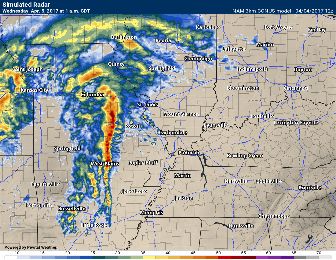
Let’s take a look at the future-cast radar for late tonight into Wednesday morning. Keep in mind, this is one models idea and forecast of what radar might look like.
This first future-cast radar map is for 1 am on Wednesday.
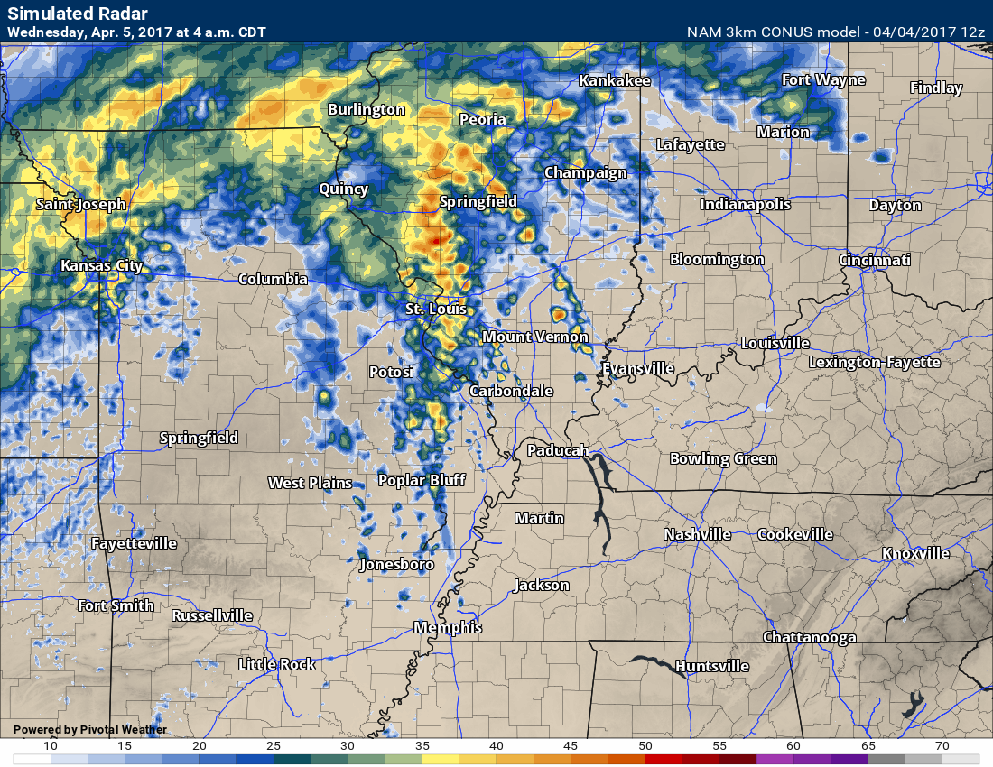
This next map is for 4 am on Wednesday
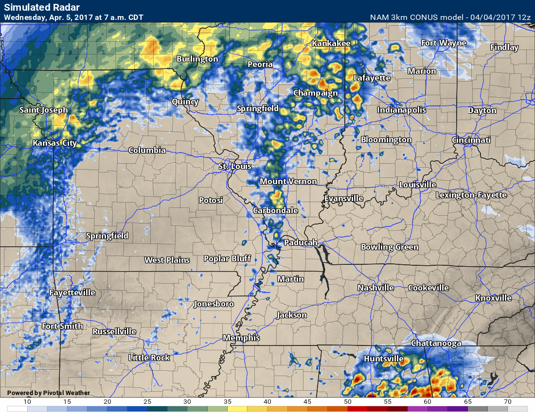
This next map is for 7 am on Wednesday
Wednesday:
A strong cold front will sweep across the region on Wednesday. The front will be accompanied by showers and thunderstorms, strong winds, and falling temperatures. Highs should top out in the upper 60’s over much of the region. Temperatures into the 70’s are not out of the question ahead of the front. This is especially true for Kentucky and Tennessee. A dying band of showers and storms will likely be ongoing at sunrise. This would most likely be over portions of southern Illinois and western Kentucky/Tennessee.
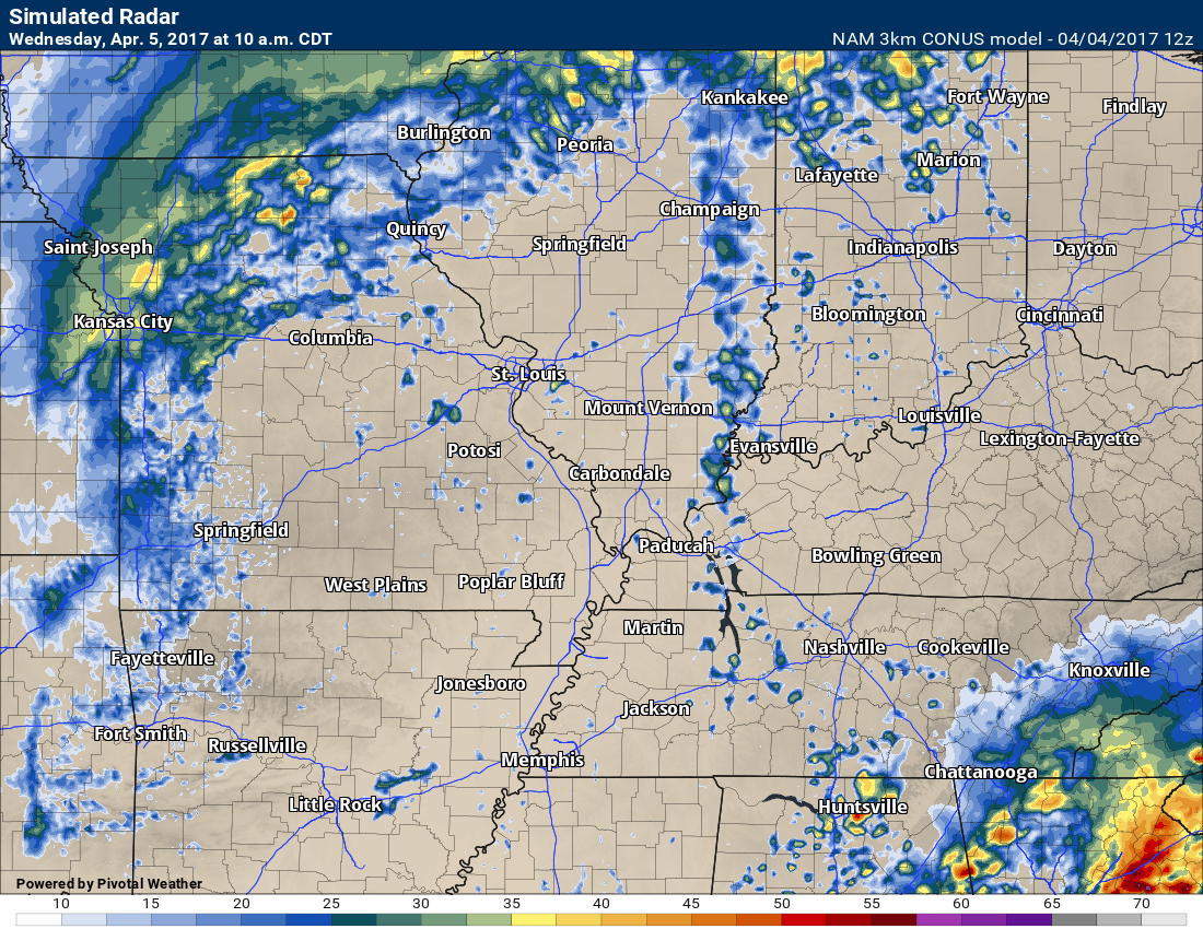
There should a be a lull in the activity during the mid to late morning hours. We might even see some breaks in the cloud cover. If we do have some sun, then this would help the atmosphere to become increasingly unstable. This will need to be monitored
Storms will redevelop ahead of the strong cold front by the late morning into the afternoon hours. The most likely area for thunderstorm redevelopment will be over southern Illinois and western Kentucky. Some of these storms could become severe with hail and high winds. Isolated tornado risk, as well.
The risk will be greater as you travel east in the region. That means that southern Indiana into the Pennyrile area of western Kentucky will have a greater risk than say Cairo or Carbondale.
Let’s look at some more future-cast radars.
This first image is for 10 am on Wednesday. You can see a lull in the activity.
This next image is for 1 pm on Wednesday
This next image is 4 pm
This next image is for 7 pm.
The Storm Prediction Center has shifted their severe weather outlook around. This was their outlook map on Monday.
If you want to view the latest severe weather outlooks then click here.
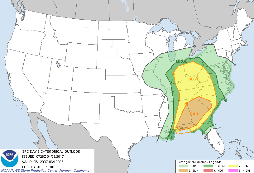
This is their new outlook (below). As expected, they have shifted westward with the threat zone.
There will likely be additional adjustments on the Wednesday morning update.
Don’t get too hung up on exactly where the colors begin and end. The bottom line is that some of the storms on Wednesday could become severe. The greatest risk zone will likely be southeast Illinois into Indiana and Kentucky. Again, the further east you drive the greater the risk.
If you want to view the latest severe weather outlooks then click here.
Falling temperatures are expected behind the sharp cold front.
Here is the 11 am Wednesday temperature map. Compare that to the 4 pm temperature map. You can easily find the cold front on this temperature forecast map.
The speed of the front will determine how fast temperatures fall. It is likely that mild air will remain into the afternoon hours and then falling temperatures as we move later in the afternoon and evening hours.
4 pm Wednesday temperature map

Find me on Twitter

We have regional radars and local city radars – if a radar does not update then try another one. Occasional browsers need their cache cleared. You may also try restarting your browser. That usually fixes the problem. Occasionally we do have a radar go down. That is why I have duplicates. Thus, if one fails then try another one.
During the winter you can track snow and ice by clicking the winterize button on the local city view interactive radars.
If you have any problems then please send me an email beaudodson@usawx.com
Interactive Weather Radar Page. Choose the city nearest your location: Click this link—
National interactive radar: Click this link.
Local interactive city radars include St Louis, Mt Vernon, Evansville, Poplar Bluff, Cape Girardeau, Marion, Paducah, Hopkinsville, Memphis, Nashville, Dyersburg, and all of eastern Kentucky. These are interactive radars. Local city radars – click here
Regional Radar


The official 6-10 day and 8-14 day temperature and precipitation outlook. Check the date stamp at the top of each image (so you understand the time frame).
The forecast maps below are issued by the Weather Prediction Center (NOAA)


The latest 8-14 day temperature and precipitation outlook. Note the dates are at the top of the image. These maps DO NOT tell you how high or low temperatures or precipitation will be. They simply give you the probability as to whether temperatures or precipitation will be above or below normal.


The Beau Dodson Weather APP is ready for Apple and Android users. The purpose of this app is for me to deliver your text messages instantly. ATT and Verizon have not always been reliable when it comes to speed. The app allows instant delivery.
Some of you have asked if you can keep receiving the texts on your phone and the app. The answer to that is, yes. The Android app will automatically allow that to happen. On the Apple app, however, you will need to go into your app and click settings. Make sure the green tab is OFF. Off means you will still receive the texts to your phone and the app. If you have any questions, then email me at beaudodson@usawx.com
The app is for text subscribers.
The direct download, for the Apple app, can be viewed here
https://itunes.apple.com/us/app/id1190136514
If you have not signed up for the texting service then you may do so at www.beaudodsonweather.com

The Android app is also ready.
Remember, the app’s are for www.weathertalk.com subscribers. The app allows your to receive the text messages faster than ATT and Verizon.
Here is the download link for the Android version Click Here

——————————————————–
If you have not signed up for the texts messages, then please do. Link www.beaudodsonweather.com
Your support helps with the following:

and


Who do you trust for your weather information and who holds them accountable?
I have studied weather in our region since the late 1970’s. I have 39 years of experience in observing our regions weather patterns. My degree is in Broadcast Meteorology and a Bachelor’s of Science.
My resume includes:
Member of the American Meteorological Society.
NOAA Weather-Ready Nation Ambassador.
Meteorologist for McCracken County Emergency Management. I served from 2005 through 2015.
Meteorologist for McCracken County Rescue. 2015 through current
I own and operate the Southern Illinois Weather Observatory.
I am the chief meteorologist for Weather Talk LLC. I am the owner of Weather Talk LLC.
I am also a business owner in western Kentucky.
Recipient of the Mark Trail Award, WPSD Six Who Make A Difference Award, Kentucky Colonel, and the Caesar J. Fiamma” Award from the American Red Cross.
In 2005 I helped open the largest American Cross shelter in U.S. history in Houston, Texas. I was deployed to help after Hurricane Katrina and Hurricane Rita. I was a shelter manager of one of the Houston, Texas shelter divisions.
In 2009 I was presented with the Kentucky Office of Highway Safety Award.
Recognized by the Kentucky House of Representatives for my service to the State of Kentucky leading up to several winter storms and severe weather outbreaks.
If you click on the image below you can read the Kentucky House of Representatives Resolution.

I am also President of the Shadow Angel Foundation which serves portions of western Kentucky and southern Illinois.
There is a lot of noise on the internet. A lot of weather maps are posted without explanation. Over time you should learn who to trust for your weather information.
My forecast philosophy is simple and straight forward.
- Communicate in simple terms
- To be as accurate as possible within a reasonable time frame before an event
- Interact with you on Twitter, Facebook, email, texts, and this blog
- Minimize the “hype” that you might see on some television stations or through other weather sources
- Push you towards utilizing wall-to-wall LOCAL TV coverage during severe weather events
Many of the graphics on this page are from www.weatherbell.com
WeatherBell is a great resource for weather model guidance.


You can sign up for my AWARE email by clicking here I typically send out AWARE emails before severe weather, winter storms, or other active weather situations. I do not email watches or warnings. The emails are a basic “heads up” concerning incoming weather conditions